
Abstract
Records of century-scale climate variability in the Upper Midwest generally agree that moisture availability increased between 4000 and 3000 cal. yr BP (calendar years before present = 1950 CE), and that there were large, frequent droughts 1000–700 cal. yr BP followed by wetter/cooler conditions. Variability among regional sites, however, remains problematic. In this study we reconstruct climate on the Northwest Wisconsin Sand Plain (NWSP), USA, to identify potential climatic drivers of previously documented changes in vegetation and fire regimes. Oak pollen was replaced by pollen from xeric pine taxa at several sites on the NWSP ~1425 cal. yr BP, accompanied by a change to larger, less frequent charcoal peaks. Another major vegetation change occurred ~700 cal. yr BP, when pollen of the more mesic
Keywords
Introduction
The general patterns of late-Holocene climate and vegetation change in the Upper Midwest region of the United States are well documented from a variety of climate and vegetation proxies, which show dry conditions during the middle Holocene with increasing moisture between 4000 and 3000 cal. yr BP (calendar years before present = CE 1950) (Bartlein and Whitlock, 1993; Brugam et al., 2004; Calcote 2003; Delcourt et al., 2002; Grimm, 1983; Jackson and Booth, 2002; Keen and Shane, 1990; Nelson and Hu, 2008; Umbanhowar, 2004). In the late Holocene, much of the Upper Midwest experienced frequent droughts during the Medieval Climate Anomaly (MCA, ~1000–700 cal. yr BP and cooler and/or wetter conditions during the Little Ice Age (LIA, ~550–250 cal. yr BP) (Bernabo, 1981; Dean, 2002; Grimm, 1983; Hotchkiss et al., 2007; Laird et al., 1996a, 1996b; Lynch et al., 2006, 2014; Swain, 1978; Tweiten et al., 2009). Dates given here are global estimates of the timing of MCA and LIA (Mann et al., 2009).
On scales of centuries and 10s–100s of km, however, studies within the Upper Midwest region do not always agree on the type or direction of climate change (Fritz et al., 2000; Laird et al., 2003; Shuman et al., 2009; St. Jacques et al., 2008). Many studies use pollen- or diatom-based climate inferences which are influenced by non-climate factors that differ among sites, including soil chemistry and texture, landscape position, disturbance history, species interactions, and cultural practices (Brubaker, 1975; Clark, 1993; Copenhaver-Parry et al., 2017; Curtis, 1959; Davis et al., 1998; Fastie, 1995; Fritz, 2008; Grimm, 1983; Lynch et al., 2014; Pederson, et al., 2014; Sayer et al., 2010; Turner and Romme, 1994; Whitmore et al., 2015). Pollen and charcoal data can be used to identify past changes in vegetation and fire regimes, and they contribute to inferences about climate changes, but they do not provide direct evidence of climate (Shuman et al., 2009). Climate records that are independent of vegetation and disturbance are required to test hypotheses about how vegetation responds to climate change.
Previous results from sites on the sandy soils of the Northwest Wisconsin Sand Plain (NWSP, Figure 1) demonstrate that there was a sudden vegetation change at Ferry Lake (Jensen et al., 2007; Lynch et al., 2006, 2014) ~1425 cal. yr BP (between 1450-1400 cal. yr BP). Pollen data suggest a rapid switch from oak (
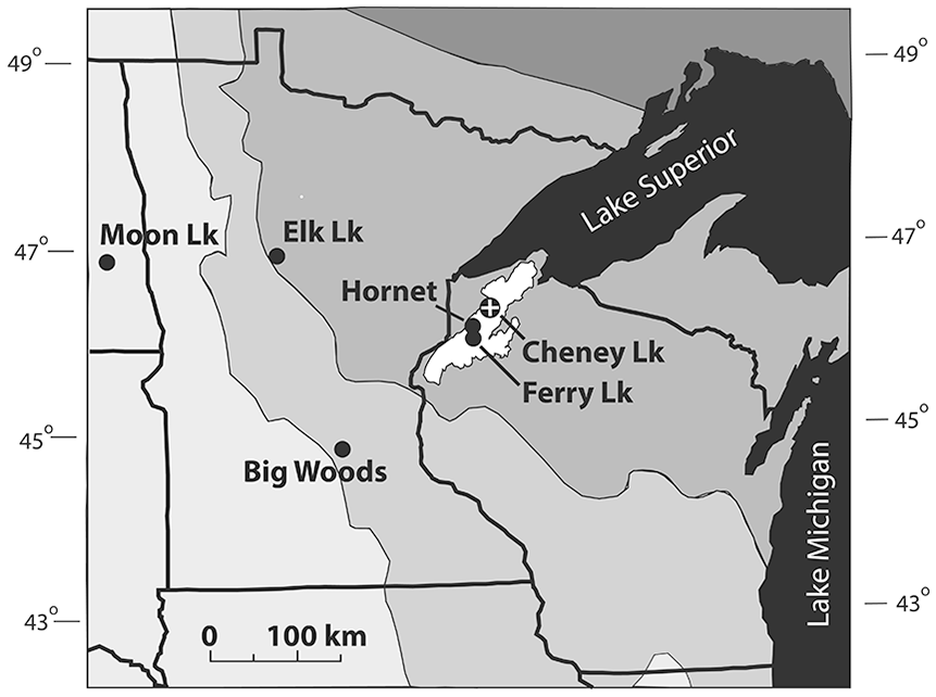
Minnesota and Wisconsin, Upper Midwest, USA. White area near center is the Northwest Wisconsin Sand Plain with Cheney Lake and other sites shown in Figure 6. Ferry Lake (Lynch et al., 2006, 2014), Hornet Bog (Tweiten et al., 2009), Big Woods (Grimm 1983; Shuman et al., 2009; Umbanhowar, 2004), Moon Lake (Laird et al., 1996a, 1996b, 2003), Elk Lake (Dean, 2002). Shaded regions indicate gradient of ecoregions from west to east; mixed prairie (light grey), deciduous forest, mixed conifer/hardwoods, boreal forest in NE (dark grey) (modified from Bailey, 1996).
It is unclear what caused the observed transition in vegetation and fire regimes at 1425 cal. yr BP. Little archaeological evidence of past Native American land use practices is available in northwestern Wisconsin, although some late-Holocene vegetation changes on the NWSP coincide with cultural events in the region (Hotchkiss et al., 2007). A sharp climatic change 1425 cal. yr BP is not documented in the Upper Midwest.
Another shift in charcoal and pollen assemblages occurred on the NWSP ~700 BP when jack and/or red pine decreased at several sites and white pine (
In southeastern Minnesota, about 200 km southwest of Cheney Lake, the increase in pollen of mesic taxa is represented by
The goal of this study is to improve our understanding of late-Holocene climatic changes on the NWSP in order to test our previous interpretation of observed changes in vegetation. We analyzed a transect of shallow-water sediment cores from Cheney Lake to reconstruct Holocene changes in lake level as a proxy for long-term average moisture availability at a multi-decadal to century scale. The climate record developed here provides independent evidence to interpret possible climatic drivers of the vegetation and fire changes on the NWSP. We use this lake-level record to test the hypotheses that a sudden increase in aridity caused the rapid vegetation changes 1425 cal. yr BP at Ferry Lake (located 50 km southwest of Cheney Lake) and that high moisture availability after 700 cal. yr BP allowed the increase in more mesic pine species on the NWSP.
Site description
Cheney Lak small seepage lake in Douglas County, Wisconsin (Figures 1 and 2a) with 8 ha surface area and a maximum depth of 5.5 m (Wisconsin Department of Natural Resources [DNR], 2009). The area currently receives ~785 mm of precipitation annually (Solon Springs, 10 km SW of Cheney Lake), with average January low and high temperatures of −17° and −6° C, respectively. Average low and high temperatures in July are 14 and 27°C (1981–2010 normals, Wisconsin State Climatology Office, 2020). Vegetation in the catchment is dominated by jack pine and Hill’s oak (
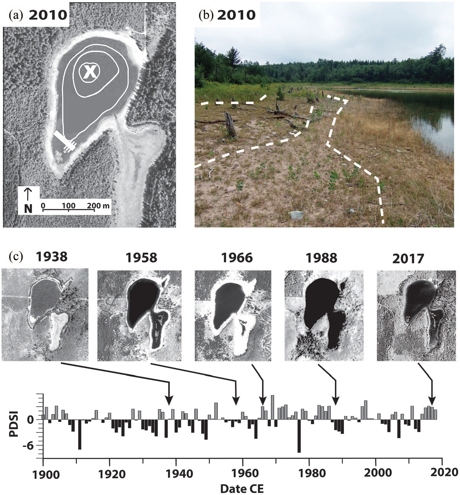
(a) September 2010 aerial photo showing bathymetry (1.5 m increments). X marks location of DW core. Diagonal line in SW indicates location of GPR transect. (b) 2010 photo of southeastern shoreline. Dotted white lines mark slope breaks and ridges interpreted as past shorelines. (c) Aerial photos showing water level in 1938, 1958, 1966, 1988, and 2017 CE. Graph shows monthly PDSI for northwestern Wisconsin (WI Climate Div. 1) from 1900–2019 (National Climate Data Center, 2018).
Methods
Sensitivity of Cheney Lake to climate of the last century
Cheney Lake has several features that suggest its sensitivity to recent changes in precipitation-evaporation balance, including former beach ridges above the modern (2010 CE) lake level and a wide terrace with stumps of dead pines (~20 cm diameter, Figure 2b). These features suggest that for several decades the lake level was low enough for trees to grow on the shoreline before the lake level rose high enough to kill the trees. Subsequently, the lake level declined again, exposing the stumps that were observed on the shore in 2010 CE.
We used current conditions around Cheney Lake, including shoreline vegetation and a series of aerial photographs taken approximately every decade from 1938 to 2017 (WI DNR photos available at the Robinson Map Library, UW Madison), to track changes in lake level over the past 80 years. Times of extreme high or low lake levels identified in the photos were plotted next to the Palmer Drought Severity Index (PDSI) time series for NW Wisconsin (National Climate Data Center, 2018) for visual comparison.
Ground-penetrating radar and sediment coring
We used ground-penetrating radar (GPR) to detect changes in sediment stratigraphy using an SIR-3000 GPR system (Geophysical Survey Systems, Salem, New Hampshire) with a 200-MHz antenna. We collected reflectance data along transects parallel to water-depth gradients to identify locations with radar reflectors that indicate changes in sediment composition. We collected sediment cores along a transect at the southern end of the lake where the slope was most gradual (Figure 2a).
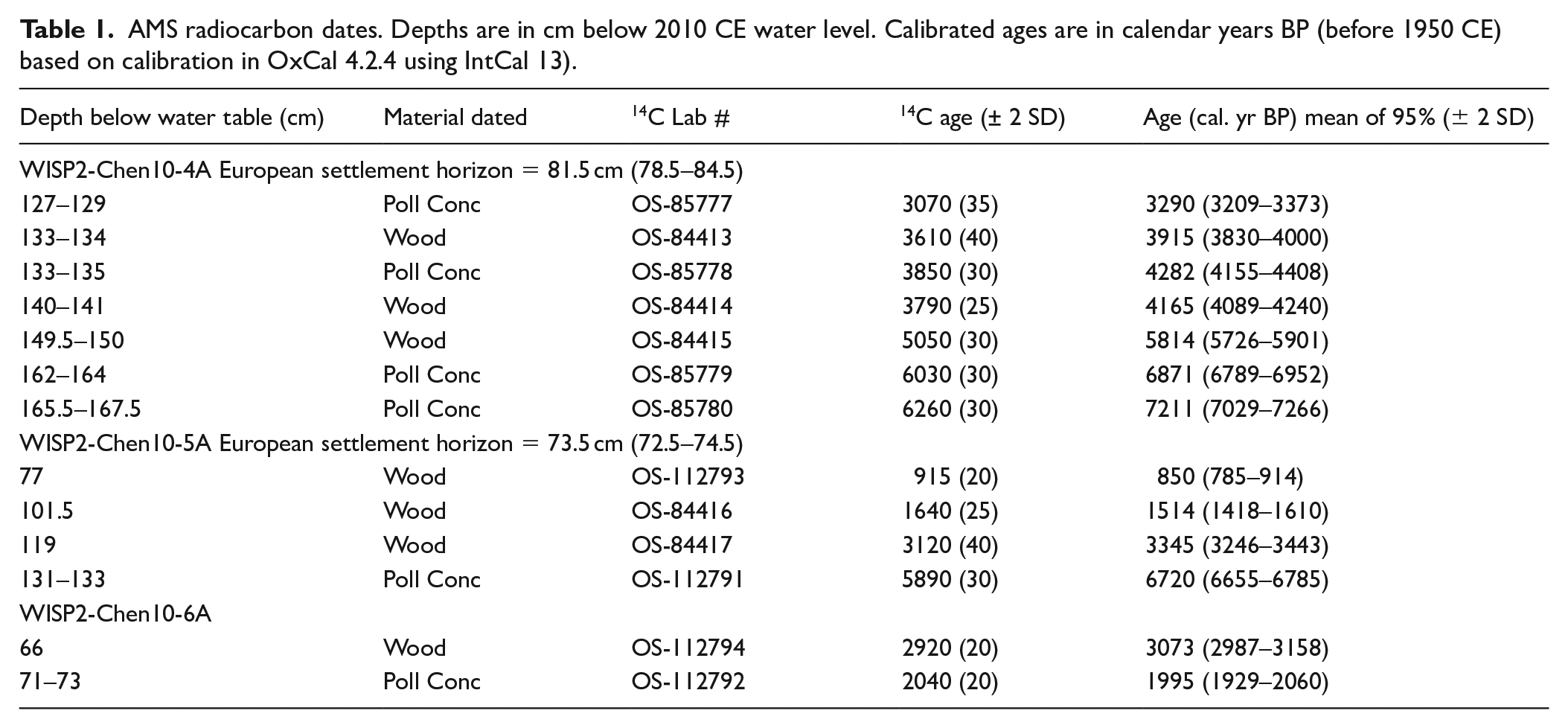
We collected six sediment cores where subsurface radar reflectors were visible along the GPR transect across the southern end of the lake in August 2010. Cores were collected using a tennis-ball piston in 7.5-cm diameter polycarbonate tubes and were split longitudinally at the LacCore Facility at the University of Minnesota. Each core was digitally photographed using a Geotek Geoscan III and scanned for magnetic susceptibility using a Geotek MSCL-XYZ (LacCore ICD procedures: http://lrc.geo.umn.edu/laccore/icd.html). Cores are archived at the National Lacustrine Core Repository, University of Minnesota. The three cores at the shallow end of the transect reached sand below the lake sediments and have been analyzed (Figure 3a). Repository core names are given in Table 1; we refer to them as cores 4, 5, and 6 in the text. Core 4 was collected in 65 cm water depth, 13 m from shore, core 5 in 55 cm water and 10.3 m from shore, and core 6 in 50 cm of water 6.7 m from shore. In this paper we refer to sediment depths in cores 4, 5, and 6 in terms of the depth below the 2010 CE water level (~340 ± 0.3 masl). We also use pollen and charcoal data from a 2.7-m long sediment core collected in 2005 CE from the central, deepest part of the lake (Figure 2a), which we refer to as the deep water core (DW, 5.2 m water depth at the time of coring) (WISP2-Chen05-1A, Lynch et al., 2014; Tweiten et al., 2015). Pollen, charcoal, and LOI data are available through the NEOTOMA database (neotomadb.org).
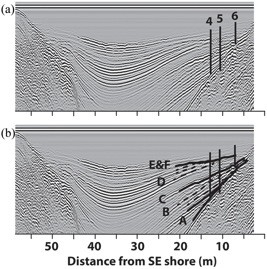
(a) GPR transect showing approximate locations of cores 4, 5, and 6. (b) Same as above, with heavy black lines indicating reflectors that occur between sediment zones A-E. Dotted lines indicate weaker reflectors.
AMS radiocarbon dates. Depths are in cm below 2010 CE water level. Calibrated ages are in calendar years BP (before 1950 CE) based on calibration in OxCal 4.2.4 using IntCal 13).
Sediment analysis and chronology
We used visible sand layers and changes in percent organic matter measured by loss on ignition (LOI) in cores 4, 5, and 6 as the primary proxies for changes in lake level. The lake level of a seepage lake on sandy soils is primarily climatically regulated through groundwater input (Almendinger, 1990; Shuman et al., 2001). The lack of inlet and outlet streams limits the probability that non-climatic drainage factors, including changes in vegetation, beaver activity, or erosion, affect the lake level.
Sand layers represent sustained periods of shallow water. In the modern lake sandy sediments occur at water depths shallower than 50 cm. At these depths, fine organic sediment is resuspended and removed by wave action, then re-deposited, resulting in greater net accumulation in parts of the lake with deeper water (Digerfeldt, 1986; Shuman, 2003; Shuman et al., 2001). The sand layers visible in the cores contained < 1% organic content (Figure 4). Changes in organic content of sediment cores determined by LOI are used to infer past changes in water level at deeper depths (Digerfeldt, 1986; Winkler et al., 1986; Shuman, 2003; Shuman et al., 2001). Organic content in the surface sediments of our shallow-water cores is positively correlated with current water depth: 20%–22% LOI in the top 3 cm of core 6 (50 cm water depth), 55%–56% in core 5 (55 cm water), and 54%–58% in core 4 (65 cm water).
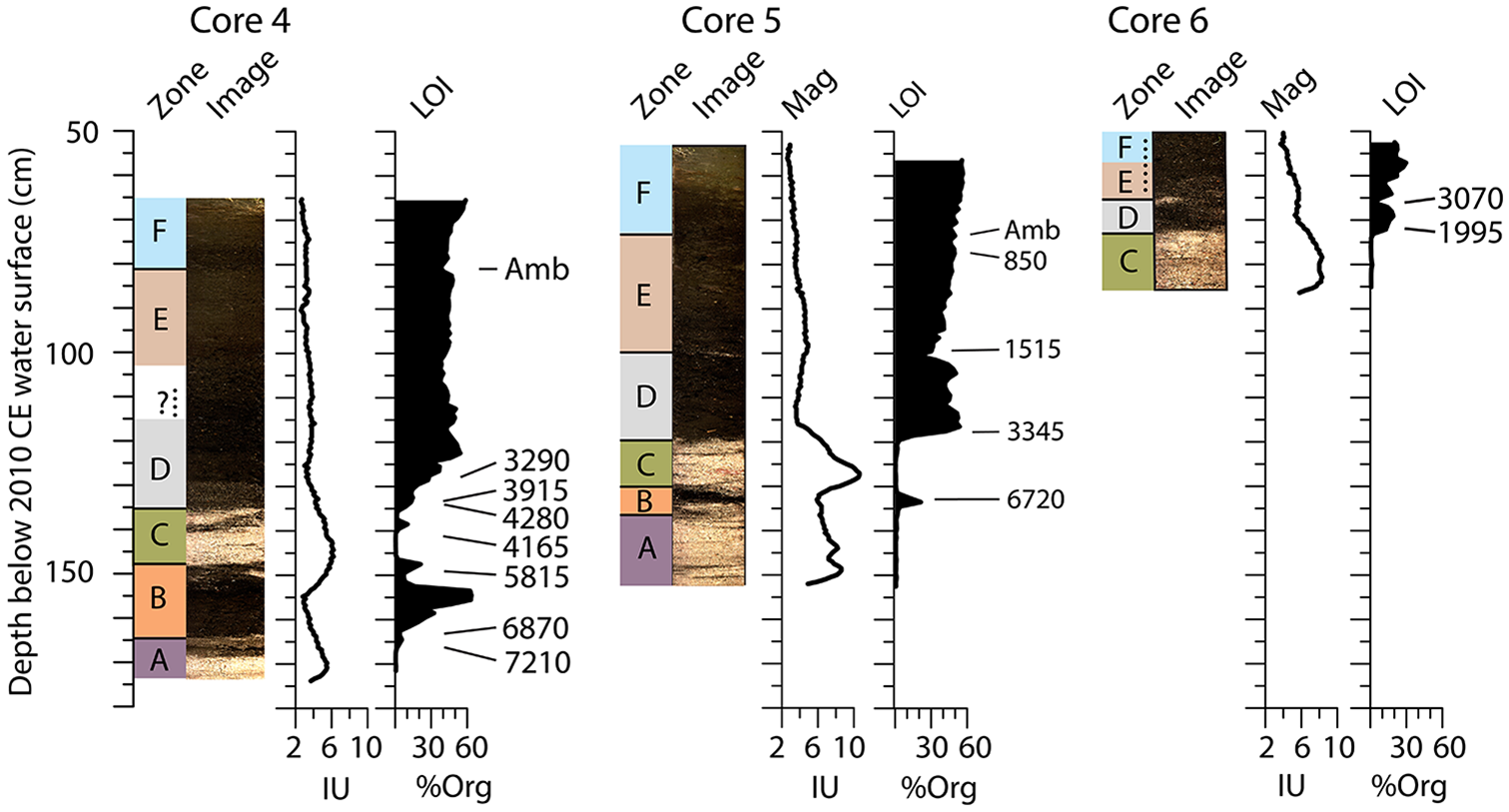
Core images, magnetic susceptibility, and LOI results for cores 4, 5, and 6 plotted as depth below the 2010 CE lake surface. AMS 14C dates (corrected to cal. yr BP) and the rise in Ambrosia pollen indicating European settlement ~70 cal. yr BP (Amb) are marked beside the LOI plots. Zones A-E are defined by sediment stratigraphy; Zone F is identified from pollen analysis.
For this study, we measured sediment organic matter content in contiguous 1-ml samples at 1-cm depth resolution. Samples were dried overnight at 100°C and LOI was determined by burning the samples at 550°C for 5 hours (Dean, 1974). LOI was performed at the LacCore facility at the University of Minnesota and at Luther College. The percentage of dry mass lost by LOI was used as a measurement of sediment organic matter content.
We collected samples for Accelerator Mass Spectrometry (AMS) 14C dating from just above and/or below sand layers. AMS dates were from macrofossils of wood or terrestrial seeds when available. Additional dates were obtained from pollen concentrates (modified from Brown et al., 1989; Regnell, 1992; Richardson, 1994). Radiocarbon dates were converted from 14C yr to calendar years using the INTCAL13 atmospheric calibration data set (Reimer et al., 2013) with OxCal 4.2.4 (Bronk Ramsey, 2001, 2013) (Table 1). Ages reported in the text and figures are rounded to the nearest 5 years; those in Table 1 are not rounded. We used the rise in the percentage of
A new Bayesian chronology for the DW core is used here, based on Bacon v 2.2 software (Blaauw and Christen, 2011) running R (v 3.4.3, R Foundation for Statistical Computing) in RStudio (v 1.1.383 RStudio Inc). Age estimates back to 2200 cal. yr BP vary by less than a decade from the previously published chronology (Lynch et al., 2014), which was based on a P_sequence Bayesian model in OxCal 4.2.4 (Bronk Ramsey, 2013) using the same dates listed in Table 1 corrected using INTCAL 13 (Reimer et al. 2013). The basal age estimate is about a century younger in the new chronology.
We compared 14C dates and organic content among the short cores to estimate the elevation of the lake surface relative to the lake level when the cores were taken (2010 CE) and to reconstruct the lake level history for the last 7200 years. For instance, a 14C date at a depth where organic matter content (LOI) is 1%–22% indicates that the water depth was at least 50 cm at the core site at the time it was deposited. If organic content is 55%–58%, we infer that water depth was at least 55–65 cm at the core site when the sediment was deposited. Intermediate LOI values indicate water depths between these limits. The limited number of 14C dates and their uncertainties, as well as the limited number of cores and sand layers, constrain the temporal resolution of our interpretation. Confidence in our lake level reconstruction is high at depths and times when a date constrains a change in sediment organic content and less certain between dates or when there is no change in the sediment.
Pollen and charcoal analysis
Pollen samples were prepared from organic sections of cores 4 and 5 at the LacCore facility using standard procedures, slightly modified from Faegri et al. (1989); see LacCore pollen processing at http://lrc.geo.umn.edu/laccore/pollenprep.html). Pollen was counted on one or two slides per sample for upland pollen sums of 197–733 grains (average = 385). Pine pollen grains were counted as either
We used the previously published pollen and charcoal record from the DW core of Cheney Lake (LacCore name WISP-Chen05-1A-1P-1). That analysis focused on upland vegetation (Lynch et al., 2014; Tweiten et al., 2015). In the current analysis we use the new chronology described above and include aquatic pollen as evidence for lake-level change, focusing especially on increases in pollen from aquatic taxa, which indicate shallow-water plants growing closer to the deep part of the lake (Digerfeldt, 1986). We use previously published charcoal data from the DW core (Lynch et al., 2014) to interpret fire history.
The DW core should preserve stratigraphy better than the shallow-water cores in which sediments could have been disturbed by wave action. For this reason, we based our vegetation interpretations for the last 2700 years on the high-resolution pollen analysis from the DW core (Lynch et al., 2014). Older sediment was not collected in the DW core, and so our interpretation of pollen/vegetation changes from 7200 to 2700 cal. yr BP is based on pollen from cores 4 and 5.
Results
Sensitivity of Cheney Lake to climate of the last century
The most extreme lake levels in the aerial photos are consistent with decadal-scale precipitation variability (Figure 2c). Small and shorter-term fluctuations of the lake level are difficult to detect because the air photos are not annual, and they were taken at different times during the growing season in different years. The aerial photo from 1938 CE (Figure 2c) has the lowest lake level of the series, with no standing water in the basin southeast of the lake. Although 1938 was a year of average moisture, it followed a period when northwestern Wisconsin had drier than average conditions in six of the previous eight and 11 of the previous 17 years (Figure 2c). A ring of trees surrounded the shoreline in 1938 (Figure 2c); most of those trees were gone by 1966 when the lake was low again (Figure 2c). We conclude that the lake level must have risen high enough during this interval to drown the ring of shoreline trees, leaving the decaying stumps that we observed on the shoreline in 2010 CE (Figure 2b).
The aerial photograph showing the highest lake level is from June 1988. Although 1987 and 1988 were dry years in NW Wisconsin, the decade from 1976 to 1986 was unusually wet, with 16 of the previous 22 years having above-average moisture (Figure 2c). The lake level was slightly higher in 2010, when the transect of short cores was collected (Figure 2a and c), than it had been in 1938, and it had begun to rise by 2017 after several years of above-average moisture (Figure 2c). The lake-level was ~1 m higher in May 2019 than the 2010 CE level (personal observation Calcote) following 5 years of above-average moisture (Figure 2c).
These results are consistent with the interpretation that the water level of the lake represents the groundwater level and integrates a decade or more of net precipitation minus evapotranspiration. Organic sediments in shallow lakes do not typically preserve annual-decadal lake level patterns. Therefore, we interpret the variations in sediment composition as indicative of long-term changes in average lake level, on the scale of several decades to centuries (Almendinger, 1990; Shuman et al., 2001).
Ground-penetrating radar
GPR scans reveal changes in the density of lake sediment that appear as dark lines in Figure 3a. The GPR transects show similar patterns of radar reflectors near the shore in all parts of the lake, indicating similar changes in sediment composition that were not caused by slumps or other localized features.
One of the GPR profiles and the locations of cores are shown in Figure 3a. Four major reflectors are marked by heavy black lines (Figure 3b), with minor reflectors indicated by dotted lines. Sediment zones are named based on changes in percent organic matter and visible changes in sediment cores (Figure 4) and are labeled in Figure 3b. Minor reflectors in zone B generally pinch out along the edge of the basin defined by late-glacial sediments, suggesting new sediments accumulated higher on the shore as lake levels rose. Minor reflectors in zone D, on the other hand, are often truncated by the edge of zone E, suggesting that previous layers may have lapped higher on the shore and were eroded away during a low lake stand that deposited the base of zone E.
Sediment analysis and chronology
The results from LOI confirm that there are essentially no organic materials (<1%) in the sandiest sections of the cores and a maximum of ~60% organic content in sediments between the sand layers (Figure 4). Radiocarbon dates (Table 1) provide a chronological interpretation of the LOI data. Magnetic susceptibility is relatively low throughout these cores, never exceeding 10 IU (Figure 4). Changes in magnetic susceptibility are consistent with those of LOI, with higher magnetic susceptibility when mineral content of sediment is high.
The deepest parts of cores 4 and 5 are composed of sand (zone A). This zone ends with the first accumulation of organic sediment in these cores. An AMS 14C date 166.5–168.5 cm below the 2010 water level of 7210 (7265–7030) cal. yr BP marks the beginning of zone B. Organic deposition peaks about 6700 cal. yr BP with 60% LOI in core 4. A small organic peak in core 5 is dated at 6720 (6785–6655) cal. yr BP (137–135 cm, Figure 4).
Sand deposition (zone C) begins again at 150 cm below 2010 CE water level (~5815 cal. yr BP) in core 4, and 135 cm in core 5. Core 6 begins with this zone (Figure 4). A small organic layer near the top of zone C in core 4 was dated at 4165 (4240–4090) cal. yr BP and probably corresponds to a smaller dark layer in core 5. A shift from sand to organic matter marks the beginning of zone D at 138 cm in core 4. Duplicate 14C dates at this depth disagree by several hundred years. A piece of wood from 134 to 135 cm was dated to 3915 (4000–3830 cal. yr BP), and a date on pollen concentrate from 134 to 136 cm was 4280 (4410–4155 cal. yr BP). A wood sample from 118–119 cm in core 5 dated to 3345 cal. yr BP. Organic content reached 40% in both cores ~3300 cal. yr BP. Zone D begins at 71 cm below the 2010 CE lake level in core 6 but dating of core 6 is problematic due to the reversal of dates in this core (Figure 4, Table 1).
Organic content remains at 40%–50% in core 5 until it drops dramatically at 100 cm below the 2010 CE lake level where a narrow light band marks the beginning of zone E. Organic content drops to a low of 19% at 101 cm (Figure 4), with an AMS 14C date of 1514 (1610–1420) cal. yr BP. The decrease in inorganic content ~1500 cal. yr BP is not as clear in the other cores. There is a slight drop in organic content in core 4 from 109 to 103 cm, but it is undated, and no visible change occurs in the core. Core 6 does have a visible light-colored band and a drop in organic content from 13% to 3%, indicating inorganic deposition at 65 cm below the 2010 CE water level, but the reversal in 14C dates makes correlation with core 5 uncertain (Table 1). Organic content in core 5 gradually increases above 101 cm until it again reaches 40% at 95 cm, and it fluctuates between 45 and 50% from 82 cm below the 2010 CE water level to the Ambrosia rise at 73 cm (Figure 4).
Pollen and charcoal analysis
Pollen data are shown in Figure 5 and charcoal data for the DW core are included in Figure 5c. The stratigraphically constrained CONISS cluster diagrams are shown to the right of the pollen diagrams, although zone boundaries shown for cores 4 and 5 (Figure 5a and b) are based on sediment stratigraphy shown in Figure 4a and b. Zones for the DW core (Figure 5c) are based on CONISS of pollen data.

Common upland and aquatic pollen types from three Cheney Lake cores reported as percentage of upland pollen. Shaded area shows 10× exaggeration of less abundant types. Core images and LOI from Figure 4 are to the left of cores 4 and 5. (a) Core 4 from the shallow water transect. (b) Core 5 from the shallow water transect. (c) Deep water core collected in 2005 plotted with new chronology includes charcoal accumulation rate (CHAR); plus symbols indicate local fire events (Lynch et al., 2014).
Zone B (~7200–5800 cal. yr BP)
The earliest pollen samples analyzed are from the base of zone B in core 4, where organic sediment first accumulated (Figures 4a and 5a). The lowest two samples in this zone contain high jack and/or red pine pollen percentages (50%–60%). This zone also has relatively high percentages of prairie forb pollen (~10%), consistent with dry conditions and a fairly open canopy.
Zone D (~3900–1500 cal. yr BP)
Analysis of pollen and charcoal in the DW core begins in zone D with a better chronology and higher temporal resolution than in the other cores. All cores have low percentages of pollen of prairie forbs (<5%) and increasing percentages of birch pollen to 10%–15% (Figure 5 a and b). White pine pollen is slightly higher in zone D of core 4 (10%–21%, avg = 17.4%) than in zone B (8%–19%, avg = 13%) but remains fairly constant throughout zone D in core 5 at ~20%. Charcoal influx rates in the DW core suggest frequent, small fires during this zone, especially between 2300 and 1900 cal. yr BP (Figure 5c).
Zone E (1500–70 cal. yr BP)
The beginning of zone E, defined by the light band and drop in LOI in core 5, has a slight increase in pollen or spores of several wetland and aquatic taxa in the DW core Figure 5c).
Zone E is broken into subzones E-1 and E-2 based on a change in the upland pollen assemblage clearly visible in the constrained cluster analysis on the pollen data from the DW core (Figure 5c). These subzones are not differentiated in the pollen or LOI of the shallow-water cores (Figure 5 a and b). Although the average total pollen percentage of pine remains 69% (sd = 4, n = 24) throughout zone E, jack and/or red pine decreases slightly between subzones, with a range of 37% to 59% (avg = 49%) in zone E-1 and 33% to 51% (avg = 41%) in E-2. White pine pollen abundance increases a similar amount, from 14% to 30% (avg = 20%) to 22% to 31% (avg = 28%) in E-2. Hemlock pollen (
A large charcoal peak occurs at the transition to zone E-1, with no charcoal peaks large enough to indicate local fires for the next several hundred years (Figure 5c, and Lynch et al., 2014). The period 1250–750 cal. yr BP, however, is characterized by frequent charcoal peaks, with the largest peak in the record occurring ~900 cal. yr BP.
The major features of subzone E-2 are a decrease in the frequency and magnitude of charcoal peaks, with only two charcoal peaks large enough to be interpreted as representing local fires in zone E-2 (Figure 5c and Lynch et al., 2014), and the rise in white pine relative to jack and/or red pine, visible in the ratio WP/R&JP pollen, which rises from an average of 0.4 in subzone E-1 to 0.7 in E-2 (Figure 5c). Aspen pollen (
Zone F (after 70 cal. yr BP)
The most recent zone is defined by changes in pollen assemblages rather than sediment composition and provides a chronological marker to identify the beginning of European logging and farming in the region (70–50 cal. yr BP). The combination of the decline of white pine pollen due to logging (avg 28% in E-2 to 12% in zone F), and the increase in pollen of
Discussion
Our analysis of sediment changes in a transect of cores collected from the south end of Cheney Lake demonstrates that the long-term average water level in Cheney Lake fluctuated by at least 1 m over the past 7200 years. The timing of these changes provides independent evidence that will help us understand how forests and fire regimes responded to past climatic changes. The overall pattern of lake level change is plotted against an approximate age scale shown in Figure 6 and interpreted in the sections below.

Middle Holocene (7200–3000 cal. yr BP) and transition to late Holocene
Our record begins 7200 cal. yr BP, when the lake level rose high enough to deposit organic sediment in core 4 (zones A and B, Figures 4 and 6). The large peak in organic sediment in core 4 is bracketed by 14C dates of 6870 and 5815 cal. yr BP, suggesting a period of high moisture in the mid-Holocene. A date of 6720 cal. yr BP on a thin layer of organic sediment in core 5 indicates that the lake level peaked at about that time. The lake level was no more than 85 cm below the 2010 CE lake level. This high stand ended about 5800 cal. yr BP when organic sediment ceased to be deposited in cores 4 and 5. At this time the lake level was more than 100 cm below 2010 CE lake level and the water depth at the location of core 4 would have been in less than 50 cm. During a subsequent period of low moisture the water level retreated below the location of our shallow-water core transect, resulting in sand deposition recorded in all cores (zone C). Thin layers of sand and organic sediment exist in zones A, B, and C, indicating that shorter-term fluctuations occurred.
The lake level rose again sharply between 4000 and 3000 cal. yr BP and organic sediment was again deposited (zone D), first at the site of core 4 (~4000 cal. yr BP), and then at the location of core 5 (~3300 cal. yr BP). This increase in moisture after 4000 cal. yr BP is consistent with other non-pollen based evidence from the Upper Midwest (Brugam et al., 1998; Dean et al., 1996; Delcourt et al., 2002; Dorale et al., 1992; Keen and Shane, 1990; Nelson and Hu, 2008; Valero-Garces et al., 1997), as well as with pollen-based climate interpretations (Almendinger, 1992; Baker et al., 2002; Bartlein and Whitlock, 1993; Calcote, 2003; Davis et al., 1998; Grimm, 1983; Wright et al., 2004).
A recent diatom-based lake level reconstruction from core 5 in Cheney Lake suggests that the lake level may have been 4–6 m higher than the 2010 CE level in zone D, 3300–1500 cal. yr BP (Woods, 2018). Our results are consistent with a dramatic increase in moisture availability between ~5000 and 3000 cal. yr BP, but there is no evidence in our LOI data that core 6 was collecting organic sediment at a rate consistent with 5–6 m of increased lake depth for 1800 years (Figure 4). It is possible that organic-rich sediments were deposited during a deeper phase of the lake and later removed by decomposition and/or erosion during a later low stand. However, with sufficient moisture it is possible for a more mesic forest to grow on sandy soils in this region, including hemlock and sugar maple (Acer saccharum Marshall) (Lytle, 2005), and it is likely that a 5–6 m rise in the lake for such an extended period would be accompanied by a large change in the vegetation. The pollen data from Cheney Lake do not suggest a large shift to more mesic taxa at 3300 cal. yr BP (Figure 5 a and b), although several sites on the NWSP have an increase in white pine pollen percentages ~2500 cal. yr BP (unpublished data) consistent with a moderate increase in moisture. The charcoal record does not show the low frequency of fires that would be expected during an extended period of extremely high moisture (Figure 5c).
Aridity and vegetation change 1500 cal. yr BP
The presence of the thin layer of sand ~1500 cal. yr BP in core 5, and possibly in core 6, suggests a period of sustained aridity, with water levels lower than 50 cm below 2010 CE lake level allowing sand deposition at 100 cm depth in core 5 (Figures 4 and 6). The slight decrease in LOI but lack of a sand layer in core 4 constrain the lake level drop to no more than about 60 cm below the 2010 CE lake level. Our LOI data are consistent with the hypothesis that there was a rapid shift from wet to dry conditions ~1500 cal. yr BP (Figures 4 and 6). Vegetation at Ferry Lake and several other sites in the southern half of the NWSP where oak pollen percentages had been >20% (Lynch et al., 2014, and unpublished data), shifted from oak to jack-red pine dominance (Figure 7 a and b) at about this time. Our estimate of the timing of the decrease in LOI at Cheney Lake is based on a single AMS 14C date on a piece of wood from core 5 (1610–1418 cal. yr BP, Table 1). The midpoint of the corrected calendar year age of this date is 1514 cal. yr BP (for 2 sd, and the range of ages using 1 sd has a 97% probability of falling in the range of 1568–1517 cal. yr BP. This is approximately 100 years earlier than our estimate of the better-dated vegetation change at Ferry Lake (1450–1400 cal. yr BP; Jensen et al., 2007; Lynch et al., 2006, 2014), and current evidence suggests that the climate change and vegetation response occurred sometime between ~1550 and 1400 cal. yr BP).
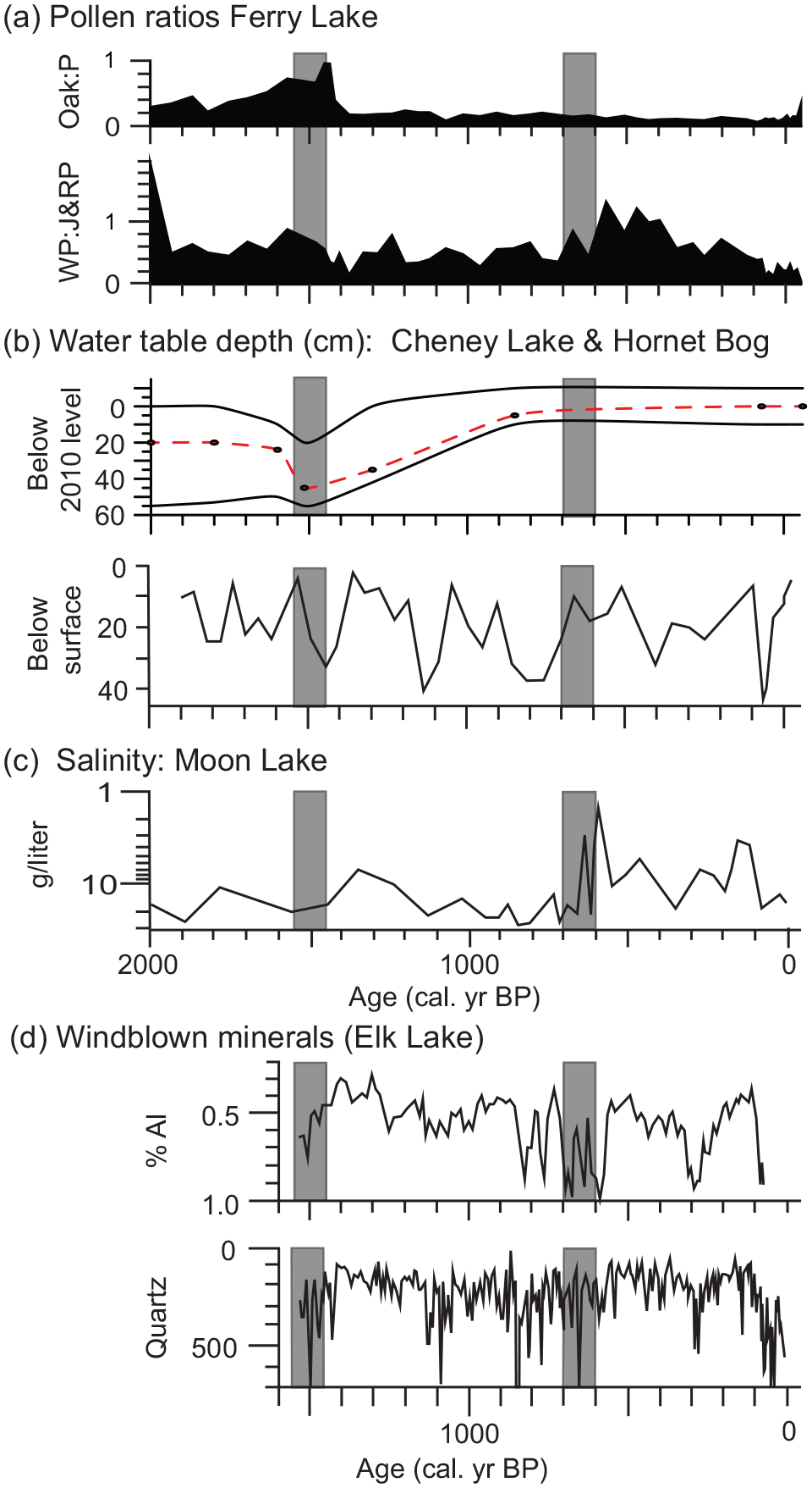
Comparison of regional climate reconstructions for the past 2000 years. All graphs are arranged with moisture levels increasing on the y-axis. Shaded vertical areas mark 1500–1400 BP and 700–600 BP. (a) Ratios of pollen types from Ferry Lake (NWSP), oak:pine, and white pine:red & jack pine. Lynch et al., 2006). (b) Moisture reconstructions from NWSP, this study, and testate amoebae derived water-level from Hornet Bog (Tweiten et al., 2009). (c) Diatom-inferred salinity for Moon Lake, ND (Laird et al., 1996b). (d) Windblown minerals in varved sediment from Elk Lake, MN, % aluminum and concentration of quartz based on x-ray diffraction (counts/sec) (Dean, 2002).
The shift from oak to jack-red pine pollen does not occur in the pollen data from Cheney Lake, even though the drop in LOI demonstrates a decrease in moisture availability. We hypothesize that the relatively high abundance of oak (~20% of upland pollen) found at Ferry Lake and Little Round Lake between 4000 and 1500 cal. yr BP (Jensen et al., 2007; Lynch et al., 2006, and unpublished data) developed in response to the abundance of fire breaks near those sites (Lynch et al., 2014). Sites with fewer fire breaks, and perhaps slightly coarser soils (Cheney Lake and Metzger Lake), on the other hand, had lower pollen percentages of oak (<10%) and were more strongly pine dominated, with 40%–50% jack and/or red pine pollen (unpublished data) and fire-vegetation feedbacks that made them resilient to the change in climatic conditions at ~1500 cal yr BP (Lynch et al., 2014).
It is not clear how widespread or long-lasting the drought was. It appears to have been severe on the NWSP, beginning rapidly ~1500 cal. yr BP and leading to major vegetation changes at Ferry Lake (Lynch et al., 2006, 2014). Evidence of a slightly drier period between 1500 and1400 cal. yr BP also occurs in the testate amoebae record from Hornet Bog (Figure 7b), 40 km southwest of Cheney Lake (Tweiten et al., 2009). A few sites across the Upper Midwest suggest slightly drier conditions ~1500 cal. yr BP. High aluminum content in sediments from Elk Lake, Minnesota suggests dry conditions 1516–1416 cal. yr BP (Dean, 2002, and Figure 7d). There is also evidence for a small decrease in relative moisture at Minden Bog, Michigan (Booth and Jackson, 2003), but most testate amoebae records from the region do not indicate a drought 1500–1400 cal. yr BP (Booth and Jackson, 2003; Booth et al., 2006).
Our interpretation of moisture availability at Cheney Lake in the centuries after 1400 cal. yr BP is less certain. The LOI data suggest a gradual increase in lake level, occurring over the course of several hundred years (Figure 4, core 5). The slow recovery of the lake level may be due to the periodic droughts of the next 700 years, documented at Hornet Bog, where there is evidence of a slightly drier period followed by more severe droughts 1190–1090 BP and 900–725 BP (Tweiten et al., 2009) (Figure 7b). Several studies have documented frequent and severe droughts after ~1200 cal. yr BP (Dean, 2002; Laird et al., 1996a; Ma et al., 2013; Tian et al., 2006) (Figure 7c).
The diatom-inferred lake level record from core 5 has been interpreted as a continuous drop in lake level, from 1500 to 500 cal. yr BP, based on a Bayesian Markov-chain Monte Carlo age model that eliminated the radiocarbon date at 850 cal. yr BP, believed to be an outlier (Woods, 2018). Although the 850 cal. yr BP date is problematic, with so few age estimates, we don’t feel we can rely on a Bayesian chronology that assumes the sedimentation rate was approximately constant for the last 3000 years. The sedimentation rate in such shallow water is likely to vary considerably with fluctuations of the water level in the lake, especially during shifts between organic and inorganic sediments.
We prefer a more conservative approach and acknowledge that the chronology between 1500 cal. yr and the European settlement horizon ~70 cal. yr BP is uncertain. We tested several age models (not shown), including deleting the 850 BP date as an outlier (Table 1). Our major conclusions are robust to differences in methods of interpolation, affecting only the rate of lake-level increase after 1500 cal. yr BP. We plot our interpretation in Figures 6 and 7b with a time scale that is based on linear interpolation between midpoints of 95% confidence intervals of all AMS 14C dates and the Ambrosia rise. The increase in aquatic pollen in the DW core and decline after several hundred years (Figure 5c) suggest that the decrease in moisture was rapid at ~1500 cal. yr BP and that the water level increased gradually, over at least several hundred years (Figures 6 and 7b).
As the lake-level of Cheney Lake eventually recovered, it is interesting to note that oak pollen percentages at Ferry Lake did not recover (Lynch et al., 2006). Oak and grass pollen percentages and grass charcoal influx decreased at about 1425 cal. yr BP at Ferry Lake, suggesting replacement of an open oak woodland with pine forests. High jack and/or red pine pollen percentages and charcoal morphology (glassy charcoal and bordered pits) verify the dominance of conifers from 1425 to 700 BP (Jensen et al., 2007). The replacement of oak by jack and/or red pine-dominated vegetation at Ferry Lake may have been catalyzed by a multidecadal drought, but the maintenance of pines as moisture increased again may have been due to sporadic droughts in the region between 1500 and 800 BP (Booth and Jackson, 2003; Booth et al., 2006; Daniels and Knox, 2005; Tweiten et al., 2009) (Figure 7b). Alternatively, once fire-dependent pines became dominant, the change in fire regime may have provided positive feedbacks for periodic crown fires and a pine forest (Figure 5c, CHAR) that remains resilient to minor climatic fluctuations (Minckley et al., 2012; Lynch et al. 2014).
Little Ice Age
Our LOI results confirm that long-term average moisture availability was high at Cheney Lake over the last 600–800 years (Figures 4 and 7b). Poor resolution of dates in the shallow-water transect of cores makes it difficult to precisely define the timing of changes, but there is no evidence from the organic content of the sediment that there was any prolonged period of low lake level during the last ~700 years (Figure 4). The high lake level at this time is consistent with the hypothesis that the increase in the more mesic white pine relative to jack and/or red pine at Ferry Lake ~700 cal. yr BP (Lynch et al., 2006) was driven by high moisture availability (Figure 7a and b).
Pollen data from the DW core in Cheney Lake also show a slight shift from jack and/or red pine to the more mesic white pine 500 cal. yr BP (Figure 5c). This feature does not occur in the shallow-water cores, (Figure 5 a and b), perhaps due to greater rates of redeposition and degradation of pine pollen grains in shallow water (Davis, 1973; Davis and Brubaker, 1973). The slight rise in the abundance of hemlock pollen in the DW core (Figure 5c) is also consistent with cooler/wetter conditions in the region during the last ~500 years (Parshall, 2002).
The decrease in the frequency of charcoal peaks that begins ~700 cal. yr BP (zone E-2) in the DW core (Figure 5c) is also consistent with wetter/cooler conditions during the last ~700 years. Decreases in charcoal occurred at several sites on the NWSP between 700 and 500 cal. yr BP along with the increase in white pine pollen, consistent with high moisture availability during this period (Hotchkiss et al., 2007; Lynch et al., 2006, 2011; Tweiten et al., 2015, and unpublished data). The difference in timing of these changes varies among sites, perhaps due to dating uncertainties, but also probably due to different responses of sites with different soil textures and abundance of local fire breaks (Almendinger, 1992; Lynch et al., 2014; Umbanhowar, 2004). Around both Ferry and Cheney Lakes, fire decreased before the increase in white pine, suggesting that a wetter/cooler climate lowered the probability of ignition and/or spread of fires, which allowed the establishment of more mesic pine taxa (Lynch et al., 2006, and Figure 5c).
Several studies record fewer, less-severe droughts, or increased moisture, after ~800–600 cal. yr BP. Diatom-inferred salinity changes at Moon Lake, North Dakota indicate that there was an increase in effective moisture (Figure 7c) after ~800 BP (Laird et al., 1996a). The record from Elk Lake, Minnesota (Dean, 2002; Dean et al., 1996), has fewer peaks in aluminum and quartz (Figure 7d) attributed to windblown dust, after 600 VY (varve years = 566 cal. yr BP). Many studies agree that the last 600–800 years were generally wetter than the previous period, but the Little Ice Age was not uniformly wet. Several high-resolution studies report widespread droughts 300–200 cal. yr BP (Dean, 2002 in Figure 7d; Nelson and Hu, 2008; St. George and Nelson, 2002; Woodhouse and Overpeck, 1998). Our Cheney Lake LOI record does not preserve any evidence of these late-Holocene droughts (Figure 4), perhaps due to sediment mixing or redeposition in shallow water that eliminates fine-scale stratigraphy (Davis, 1973; Davis and Brubaker, 1973).
Our lake-level record from Cheney Lake supports the general conclusion that the long-term mean climate of the upper Midwest during the last ~600–800 years was, on average, wet and/or cool relative to the previous 500 years (Dean, 2002; Laird et al., 1996). Although questions remain about the type of climate changes that allowed the expansion of mesic “Big Woods” forest in Minnesota (Shuman et al., 2009), our results show that mesic taxa expanded on the NWSP during the last 700 years, a period when moisture availability was high and fire frequency was low.
Conclusion
The lake-level record from Cheney Lake is consistent with regional trends, including a major increase in moisture between 4000 and 3000 cal. yr BP, drier conditions during the Medieval Climate Anomaly, and high moisture availability during the Little Ice Age. Our results confirm that an extreme, sustained drought occurred sometime between 1500 and 1400 cal. yr BP. The geographic coverage and duration of this drought remain uncertain, but a rapid and substantial lake-level drop on the NWSP coincided with a dramatic and sustained change in forest composition and disturbance regimes at several sites (Lynch et al., 2006, 2014). Our results are also consistent with the hypothesis that long-term average moisture availability was high during the Little Ice Age (~700–100 cal. yr BP), leading to decreased fire frequency and a rise in white pine relative to jack-red pine at several sites on the NWSP.
Footnotes
Acknowledgements
We thank Phil Woods, Mark Edlund, Holly Ewing, Eric Grimm, David Mladenoff, and Mark Shapley for many conversations that helped with this analysis and two anonymous reviewers whose comments greatly improved the manuscript. Field and lab assistance were provided by Jake Siewert, Phil Woods, Christa Drake, and Oliver H. Tikoff. The LacCore facility at the University of Minnesota provided equipment, facilities, and core archiving.
Funding
The author(s) disclosed receipt of the following financial support for the research, authorship, and/or publication of this article: This work was supported by NSF grants DEB-6760756, DEB-0816762, and DEB-0816557, a Pittman-Robertson grant through the Wisconsin Department of Natural Resources, and a grant from the University of Wisconsin-Madison graduate school.