
Abstract
The Yellow River floodplain represents a fertile landmass that contributes significantly to human welfare and thus has been colloquially known as the birthplace of Chinese civilization. The sediment-laden nature of the Yellow River gave rise to a super-elevated channel belt, which is prone to failure particularly in the summer months when excessive precipitation occurs, resulting in cataclysmic floods traditionally regarded as “China’s Sorrow.” Therefore, a deeper understanding of levee breach frequency in this area is especially important for the assessment of socio-economic risk of levee breaches associated with future climate changes. To better understand the nature, evolution, and driving mechanisms of levee breaches on the lower Yellow River, it is necessary to place the instrumental data within a longer time framework. Here, we retrieve past information about levee breaches on the lower Yellow River since AD 11 from various documentary sources such as official histories of China. We evaluated each line of descriptions and narratives about the location, timing, and nature of each event in these documents, ending up with a detailed timeline of levee breaches on the lower Yellow River during the last 2000 years on an annual time scale. Our results reveal remarkable variations in the frequency of levee breaches superimposed on a long-term increasing trend. In addition to climate changes, the iterative embankment-siltation-breaching process caused a feedback: more breaches result in much more channel siltation, which in turn leads to even more breaches. The enhanced farming in the Loess Plateau played a pivotal role in the formation and operation of this positive feedback. Our findings may not only help improve the assessment of socio-economic risk of levee breaches associated with future climate changes, but also provide consulting information for hydraulic engineering and infrastructural designs in the lower Yellow river area.
Introduction
Large rivers are a key component of the fluvial-marine sediment source-to-sink systems and they represent an active morphodynamic agent that has been playing an important role in shaping the landscape of the Earth (Latrubesse, 2015; Lawton, 2014; Leithold et al., 2016). As global sea level rose and approached the present-day position by about 7000 years ago (Lambeck et al., 2014; Siddall et al., 2003), these exoreic fluvial systems turned from incision to aggradation, making them prone to flooding and thus giving rise to large floodplains and deltas (Stanley and Warne, 1994). These fluvial systems are also extremely sensitive to climate changes. The 20th century has seen a number of catastrophic floods in many large rivers of the world (Arnell and Gosling, 2014). Both observations and modeling have showed that the frequency of large floods (floods with discharges exceeding 100-year levels from basins larger than 200,000 km2) increased substantially and the trend in risk of large floods may continue under the ongoing global warming (Alfieri et al., 2017; Hirabayashi et al., 2013; Milly et al., 2002). Existing palaeoflood records showed that, regulated by climate changes, many large fluvial systems have experienced hydrological variability during the recent geological past (Benito et al., 2008; Ely et al., 1992; Knox, 2000; Munoz et al., 2018; Wilhelm et al., 2013, 2016; Yu et al., 2020; Zielhofer et al., 2010). Therefore, to better understand the nature, evolution, and driving mechanisms of morphodynamic and hydrological changes of the fluvial systems, it is imperative to place the instrumental data within a longer time framework of firm chronological constraints.
In addition to climate changes, human activities have begun to exert remarkable impacts on the fluvial systems during the late-Holocene (Best, 2019; Macklin and Lewin, 2015). The sediment-laden Yellow River represents an exceptional example in this regard (Chen et al., 2012; Kidder and Zhuang, 2015; Mostern, 2016; Zhuang and Kidder, 2014). With a total length of 5464 km, the Yellow River is the second largest river in China and the sixth longest river in the world. The river originates in the northeastern Tibetan Plateau and descends into the semi-arid grasslands of the Chinese Loess Plateau (Figure 1), which characterizes its middle course. Although this region accounts for only 45.7% of the total catchment area, it contributes 92% of the sediment load to the river (Xu, 1998). East of Zhengzhou, the river flows northeastward and releases its massive sediment load, thereby giving rise to a vast floodplain that has been densely populated from the Neolithic onward. Therefore, the Yellow River has long been regarded as the cradle of Chinese civilization. Also, with a mean annual sediment load of 1.5 billion tons, the Yellow River represents the most sediment-laden river in the world. This sediment-bearing nature makes the river inclination to flooding and course shift (Chen et al., 2012).
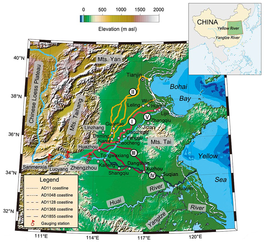
Map showing the topographical feature of the middle and lower Yellow River areas and changes in the main river channel during the last 2000 years. Major river channel stages: I = AD 11–1048, II = AD 1048–1128, III = AD 1128–1368, IV = AD 1368–1855, and V = AD 1855–present. Circled dots indicate place names mentioned in the text and gauging stations from west to east are Shanxian, Xiaolangdi, and Huayuankou.
The Yellow River has been increasingly managed by humans through dam constructions during the last century (e.g., the Sanmenxia Dam constructed during 1957–1960 and the Xiaolangdi Dam constructed during 1994–2000), whist large-scale embankment, canal construction, and channelization for flood control can be traced back to as early as the Western Han Dynasty (206 BC–AD 9) (Kidder et al., 2012a, 2012b). It has long been known that river engineering may enhance flood frequency. For example, embankment may increase in-channel sedimentation rates and reduce the drainage capacity of the channel, which in turn may amplify the frequency and magnitude of flood hazards (Criss and Shock, 2001; Munoz et al., 2018; Pinter, 2005). The continuing heightening of the levees during subsequent dynasties eventually gave rise to a ca. 800 km-long super-elevated channel belt that perches above the surrounding floodplain by as much as around 10 m, thereby leading to frequency levee breaches and river avulsions. Although numerical modeling and statistical analyses were conducted (Chen et al., 2015, 2019), the operational mechanisms and variability of this embankment-siltation-breaching feedback are still not well understood.
Given the disastrous nature, levee breaching is one of the most hazardous natural events to human livelihood in the Yellow River floodplain during the last 2000 years (Kidder and Liu, 2014; Wu et al., 2019). It is also the trigger event for river avulsion, which played a pivotal role in sediment dispersal and the evolutions of the floodplain landscape (Chen et al., 2019; Nienhuis et al., 2018). A deeper understanding of levee breach frequency and their relationship with climate changes, human activities, and the fluvial landscape evolution requires precise timing on these events. Spillage deposits, such as crevasse splays, in the fluvial setting are sedimentary archives that may provide a long-term perspective on the variability of levee breaches (Lewin et al., 2017). However, dating the floodplain sediments is challenging. For example, optical dating of fluvial deposit is subject to large uncertainties because of the insufficient exposure of the quartz grains while traveling with the floods for a short distance (Hu et al., 2010; Zhao et al., 2019). Plant remains found in fluvial sediments are usually reworked, thereby yielding radiocarbon ages much older than the actual ages of the flood events (Tao et al., 2015; Yu et al., 2018).
The Yellow River floodplain is a cultural landscape that has a long-documented history of human settlement. Meticulous narratives and descriptions of historical breach events can be found in many official and local archives, providing reliable sources that can be used to reconstruct the timeline of levee breaches on the lower Yellow River with an extremely high temporal resolution. Although previous attempt has ever been made to compile the history of levee breaches in this area (Shen et al., 1935; Yellow River Conservancy Commission, 2001), this work is often contradictory due to the variety of sources used. Also, no distinction was made between artificial and natural breaches, as well as those occurring in different seasons. Therefore, a systematic collation is needed to provide an accurate, complete, and consistent dataset, based on which previous analyses of levee breaches and their relationship with climate changes and external forcing may be reevaluated (Wang and Su, 2013; Xu and Li, 2019). Here we present an up-to-date dataset of levee breaches on the lower Yellow River that covers a time period of the last 2000 years. Our analyses on this dataset may not only deepen our insight into the relationship of level breaches with regional climate changes and human activities, but also inform policy regarding flood prevention and regulation of water resources.
Study area
The lower Yellow River floodplain (32°N–42°N, 112°E–122°E) is a low-relief landmass bounded by Mts. Taihang to the west, Mts. Yan to the north, the Bohai and Yellow Seas to the east, and the Huai River to the south (Figure 1). It is essentially a complex of numerous crevasses splays and fluvial fans built up by the overflow water of the Yellow River and several other proximal rivers originating in Mts. Taihang and Tai within a Cenozoic saucer-shaped, rifted intraplate basin (Zhao, 1986). The elevation of this area is approximately 50–100 m asl, which decreases gradually to around 5–10 m asl on the deltaic plain. The primitive vegetation in this area is temperate broad-leaved deciduous forests, most of which were cleared and turned to croplands by about 6500 cal yr BP (Ren, 2007; Yi et al., 2003).
Regulated by the East Asian monsoon system, climate in this area exhibits a marked seasonality in both precipitation and temperature. Cold and dry winds derived from the Siberian High prevail during the winter (December–February). Conversely, warm and humid air masses emanated from the Pacific High dominate the regional wind pattern and hydrological cycle during the summer (June–August). Both mean annual temperature and annual precipitation in this area shows a strong spatial variability, following a nearly SE-NW gradient: the mean annual temperature decreases from 17°C to 12°C and the annual precipitation decrease from 900 mm to 500 mm from the southeastern coast to the inland area. Most importantly, lying in a seasonal frontal zone that separates the air masses with large contrasts in temperature and humidity, this area is prone to flooding during summer, especially when the slow-drifting cold fronts collide with the moist and unstable subtropical-derived air masses, whereas extreme drought may occur when it is occupied by the subtropical High for a prolonged period.
The Yellow River is known for the extremely high concentration of suspended sediments (Xu, 1998). According to the instrumental data at the Shanxian gauging station (Figure 1) from 1919 to 1949, average water discharge is 1840 m3/s, and sediment concentration varies between 35 and 40 kg/m3 with an average of 37.8 kg/m3. Annual sediment load is 1.6 Gt, 88% of which originated in the intensively exploited Chinese Loess Plateau. Discharge during the flood season (July–October) accounts for around 57% of the total annual discharge, with sediment load during this time accounts for ca. 82% of the total annual sediment load. The deposition of excessive volume of sediments in the channel resulted in a super-elevated river bed. Levee construction keeping pace with rapid channel aggradation has raised the river bed up to 5–15 m above the surrounding ground level, making the river prone to siltation, breaching, and avulsion. However, construction of several large dams in the upper and middle reaches of the river, as well as the implementation of a soil conservation program in the Chinese Loess Plateau, has resulted in a substantial reduction of the sediment yield from the river to the ocean (Wang et al., 2016). Low-flow and no-flow events occurred in recent years due to this and changes in the climate.
The formation and evolution of the floodplain is closely related to the channel avulsion of the Yellow River during the last 4000 years (Chen et al., 2012; Kidder and Zhuang, 2015). The course had even captured the Haihe River to the upmost north and the Huai River to the upmost south and shifted back and forth across Shanxi, Hebei, Henan, Shandong, Jiangsu, and Anhui Provinces, affecting a vast area over 310,000 km2. Given the highly conducive condition to agriculture, the Yellow River is considered the cradle of Chinese civilization (Zhuang and Kidder, 2014). It is also known as “China’s Sorrow” as catastrophic levee failure has occurred 1593 times and there have been 26 major channel shifts during the past 3000 years (Chen et al., 2012), with an average of two levee breaches every 3 years and one avulsion per century, causing millions of deaths, loss of infrastructure and properties, and social upheavals. Due to lack of effective long-term maintenance and triggered by a large flood, a devastating levee failure at Tongwaxiang in Henan Province in AD 1855 caused an avulsion, thereby giving rise to the present-day course that drains to the Bohai Bay.
Data sources and methods
Compilation of breach event timeline
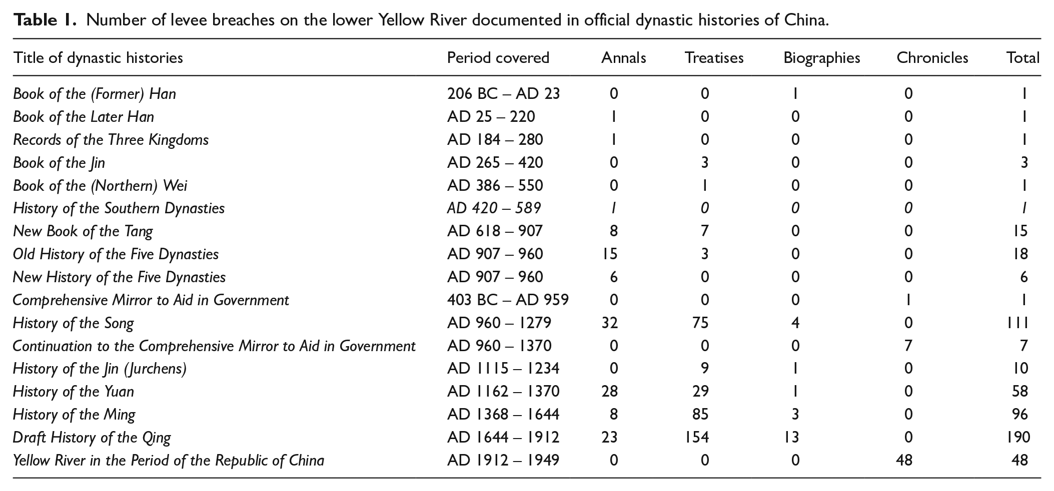
The Yellow River floodplain is one of the most densely populated regions of China. A wealth of historical records about levee breaches, repairs, constructions, and maintenance spanning the last 2000 years can be found in a large variety of documents held by the central Government. For example, in the biography of Yang Fangxing in Draft History of the Qing, it was noted that: “In August 1650, the Yellow River breached through its levee on both side at Jinglongkou, bursting into tons of water at the village of Shanjiazhai along the south bank and at the village of Zhuyuanzhai along the north bank. As the breach on the south bank was closed first, the outburst was diverted to the north, which resulted in extensive levee breaches and widespread inundation in the Zhangqiu area”. Therefore, an accurate and complete history of levee breaches can be reconstructed from these historical observations. This has been undertaken previously, for example, Shen et al. (1935) collated historical events related to the Yellow River regarding levee breaches and repairs, overspills, course displacements, and river regulations events and listed them in seven tables. This work was subsequently used by the Yellow River Conservancy Commission (1984, 2001), and the events were rearranged according to the chronological order of Chinese dynasties. In a recent study (Li et al., 2020), the Yellow River flooding frequency during the last two millennia was reconstructed based on the reanalysis of this dataset. In that study, the breach and overspill events were combined and simply interpreted in terms of flooding, and the frequency of which was calculated by counting the total number of event years over a 10-year period.
Our compilation and analyses of the breach events differs from previous work in several aspects. Firstly, only official dynastic histories of China were used (Table 1). These documents are literally orthodox and represent the paradigmatic style of writing in traditional Chinese bibliography. Breaching events were usually documented meticulously in the subcategories of imperial annals of emperors and empresses, treatises on various topics of statecraft such as administrative geography, the five processes, hydraulic works, and natural anomalies, individual biographies of distinguished officials and scholars as well as event chronicles. Given the authority of these documents, the levee breaches and overspills reported to the central government should be accurate and complete. Secondly, the man-made breaches were excluded from our compilation to show only the frequency of natural breaches. The Yellow River has been militarized occasionally, particularly during times of warfare. For example, during the Five Dynasties and Ten Kingdoms (AD 907–979), the Central China Plain was in the midst of war. The dyke of the Yellow River was often breached artificially to limit the mobility of the enemies. The most recent artificial breaching was made at Huayuankou in June 1938 by the Chinese military command as a strategic interdiction to halt the invasion of the Japanese army further west. A cataclysmic flood swept through the breach, killing half a million people and turning millions of others into refugees. Thirdly, only breaches occurring in the summer months were included in our compilation. Breaches and overspills may occur sometimes in the spring (March–May), particularly when the river flowed northeastward and discharged into the Bohai Bay (Zhao, 2007). An enlarged temperature gradient along the lower Yellow river course may have existed during these periods, which caused the river ice to melt earlier in the middle reaches than that in the lower reaches and thus made the river prone to ice-jam floods during the spring. Unlike those occurring in the summer, these breaches have a different climate implication (Jiang et al., 2008).
Number of levee breaches on the lower Yellow River documented in official dynastic histories of China.
The geographical coordinates of the closest village to the site at which a breach occurred were used to represent the spatial location of the breaching events. For the place names no longer in use, the spatial information was determined using their present names cross-referred in the Encyclopedic Dictionary of Ancient and Modern Chinese Geographical Names (Dai, 2005). To visualize the spatial distribution of the breaches, the coordinates were plotted on the historical map of channel displacement that has been previously published. These maps were created based on historical documents as well as geophysical investigations on palaeochannels and archaeological excavations (Tan, 1982).
Calculation of breach frequency
For a longer time scale, examining the variability in breach frequency or intensity may help better understand the driving mechanism of hydrological changes of a river system (Faulkner et al., 2020). In this study, an event time series in terms of breach year (years characterized by one or more breaches), denoted as F, was first developed by using a binary expression with 1 denoting the presence and 0 the absence of breach(es) for a year. Note that there might have more than one levee breaches at several different locations at the same time. For this case, they were still counted as one event year. A breach frequency time series, say P, was then constructed using the following equation

where K is the total number of breach years over a time period of N years, which was calculated from
This operation is a convolution of the breach event time series, F, with a discrete rectangular window function, W, which was defined as an array with N entries of 1. Here N was assigned with 31. We used this size of the window function because this interval represents a climate norm that has been widely used to compile and compare multiple palaeo-records (Cobb et al., 2013; Munoz et al., 2018). The computation was implemented using the MATLAB® built-in function conv.
Modeling the probabilistic response of breach to flood magnitude
We model the probabilistic response of levee breach, p, to peak discharge, Q, using a sigmoid function of the form
Detection of the long-term trend of breaches
The trend of levee breaches was detected using the locally weighted scatterplot smoothing (LOESS) method (Cleveland, 1979). It is a nonparametric method that uses the local weighted regression to fit a smooth curve through data points to reveal the trend in the data that might be difficult to model using a parametric curve. The smoothing process includes four steps: (1) specifying a smoothing parameter that represents the proportion of data to be used for local regression at a data point, (2) finding the number of nearest neighbors to a data point, (3) calculating the weight of each point in the nearest neighbors to a data point, and (4) conducting local weighted regression using the points in the local neighborhood of a data point. These steps were implemented collectively using the MATLAB® built-in function smooth.
Results
Timeline and frequency of breaches
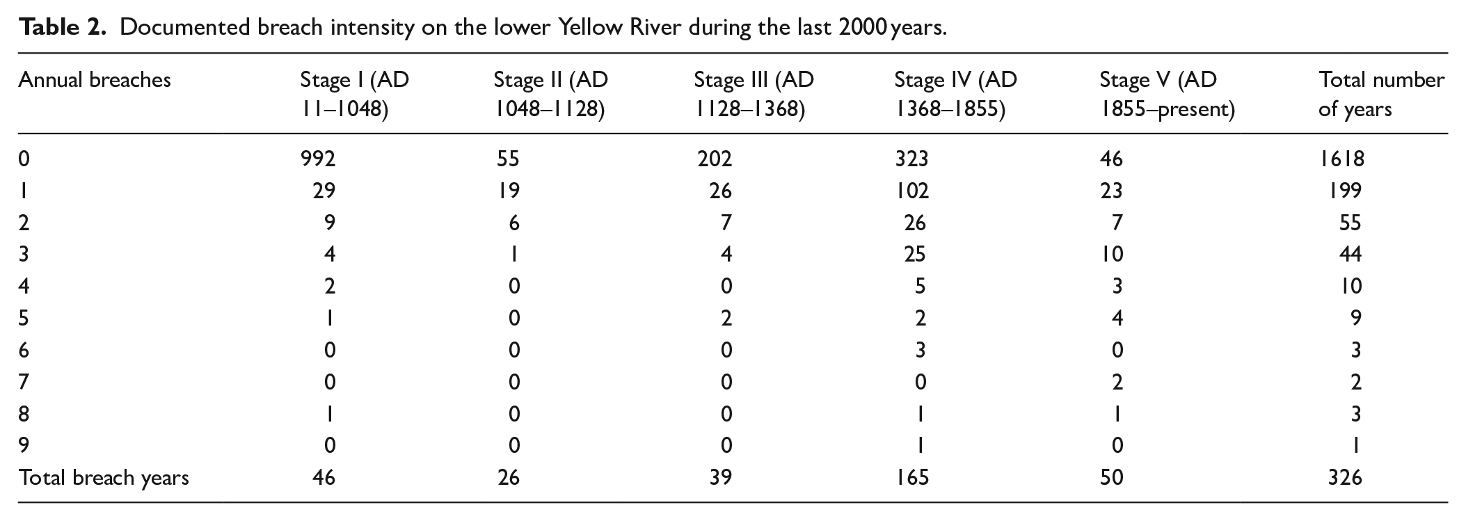
Although the lower Yellow River has shifted its course frequently (Chen et al., 2012), significant channel displacement can be divided into five major stages during the last 2000 years (Wang and Su, 2011): Stage I (AD 11–1048, Stage II (AD 1048–1128), Stage III (AD 1128–1368), Stage IV (AD 1368–1855), and Stage V (AD 1855–present). Therefore, we arranged the breaching events according to these stages and presented them in five supplemental tables (Tables S1–5 in Supplemental Material). A summary of these information was provided in Table 2. A total of 588 natural breaches during the summer months were retrieved from the official dynastic histories of China covering the period from AD 11 to 1949 (Figure 2a). There are 326 event years (a year in which one or multiple breaches occurred) during this period (Table 2), most of which occurred after AD 893 (Figure 2a). There are 1618 years that no breaches occurred. Extremely extensive breaches are very rare and there is only once occurring in AD 1448, during which nine breaches occurred along the river.
Documented breach intensity on the lower Yellow River during the last 2000 years.
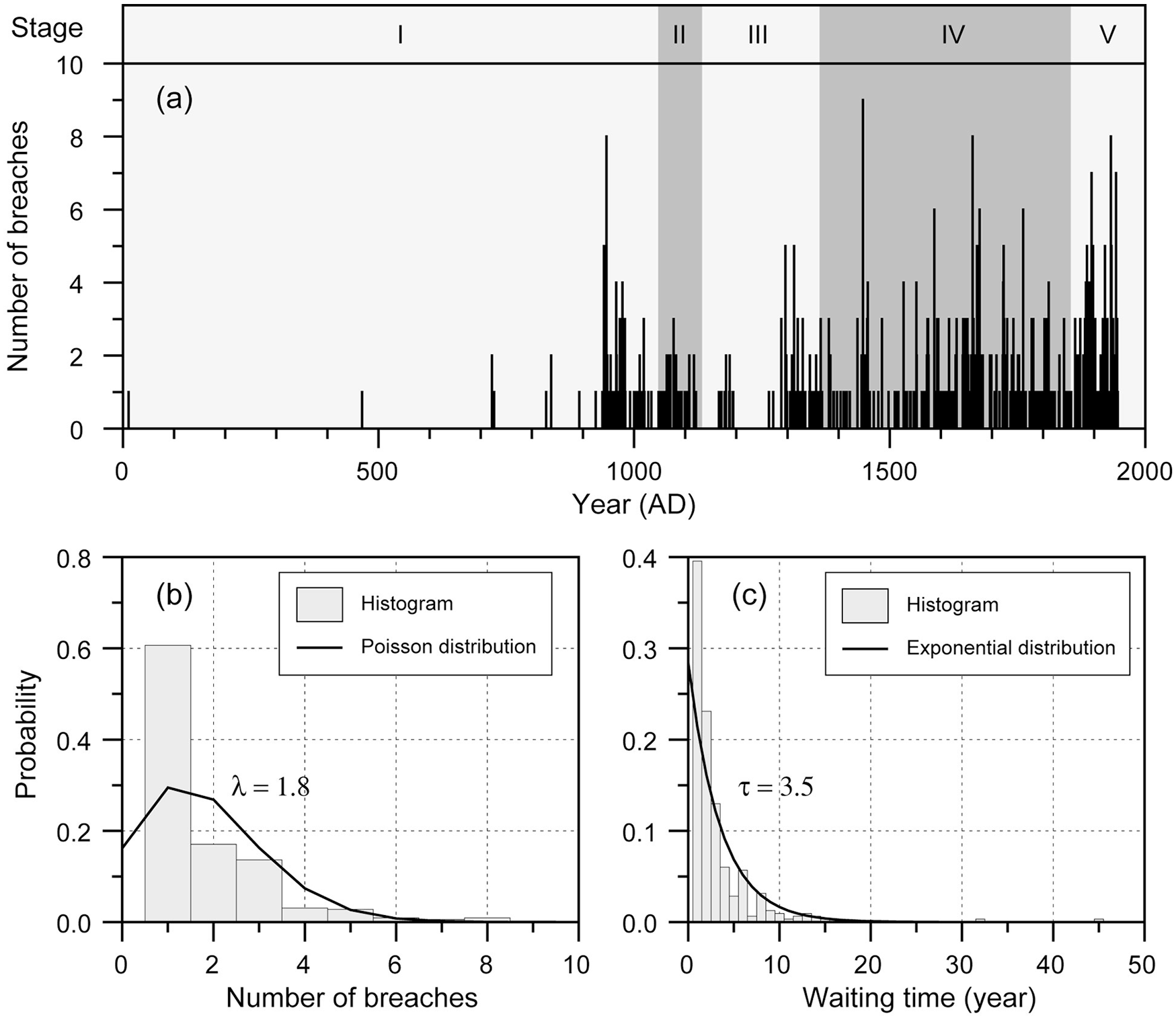
Timeline of levee breaches on the lower Yellow River during the last 2000 years and frequency distributions. (a) Number of breaches in each breaching year, shaded vertical bands highlight the major channel stages: I = AD 11–1048, II = AD 1048–1128, III = AD 1128–1368, IV = AD 1368–1855, and V = AD 1855–present. (b) Probability distribution of breach number in the event years. (c) Probability distribution of waiting time for next breach.
It appears that the number of breaches varies in each breach year and usually there was only one breach in most of the breach years, but multiple breaches occurred occasionally in some breach years. For example, there were eight breaches occurring in AD 946, 1662, and 1933 and nine breaches occurring in AD 1448 (Figure 2a). If the number of breaches in an event year can be regarded as a random variable, empirically, it follows the Poisson distribution. Fitting the data to the Poisson distribution yields a mean breaches of around two (λ = 1.8) for the event years (Figure 2b). Also, the time interval (waiting time) between each two consecutive breach years can be regarded as a random variable. As a corollary, it follows the exponential distribution. Fitting the data to the exponential distribution yields a mean waiting time of 3.5 years for next breach (Figure 2c). The calculated frequency of breaches during the last 2000 years was presented in Figure 3. Remarkable variability in the breach frequency occurred after AD 893 with an average of 0.17. Note that the breach frequency decreased substantially since the foundation of the People’s Republic of China (AD 1949) due to the intensive river managements including levee construction, maintenance, and dam constructions as well as climate changes (Piao et al., 2010).
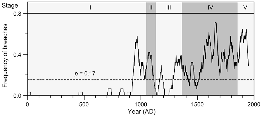
Frequency of breaches in a 31-year moving window. Horizontal dashed line indicates the average frequency of levee breaches and shaded vertical bands highlight the major channel stages: I = AD 11–1048, II = AD 1048–1128, III = AD 1128–1368, IV = AD 1368–1855, and V = AD 1855–present.
Temporal and spatial variability of breaches
The location of breaches on the main channel and its flood ways during the five major stages was plotted in Figure 4. Note that there were often multiple breaches occurring at different locations within a single year (classified as a breach year) and more than one breaches occurring at the same location during each stage. The temporal variations were highlighted using different size of symbols, while the spatial variations were unable to highlight on the maps. The reader is referred to Tables S1–5 for detailed spatial information about the breaches within each stage.
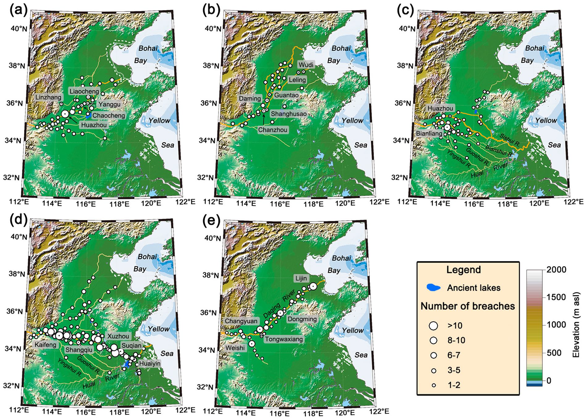
Map showing historical channel changes of the lower Yellow River. Filled circles indicate the location of levee breaches and orange and yellow lines denote the main river channel and flood ways, respectively. (a) Stage I (AD 11–1048), dashed and dotted lines denote the AD 11 and AD 1048 coastlines respectively. (b) Stage II (AD 1048–1128), dashed line denotes the AD 1128 coastline. (c) Stage III (AD 1128–1368), dashed line denotes the AD 1368 coastline. (d) Stage IV (AD 1368–1855), dashed line denotes the AD 1855 coastline. (e) Stage V (AD 1855–1949). Detailed information about breaches during these stages was given in supplementary Tables S1–5 .
Stage I (AD 11–1048)
This period is marked by the initiation of a distributive river system including the main channel and its floodways (Figure 4a, Table S1). The channel of the lower Yellow River became unstable following the vertical aggradation of the river bed and embankment since 206 BC (Kidder et al., 2012a). Nevertheless, the breach frequency was extremely low and there were only a few breaches occurring during the first half of this stage. For example, there were no breaches documented during the period of AD 304–439, while the lower Yellow River area was occupied by the nomadic people (Li et al., 2020). A breach occurred in the west of Weijun, what is now Linzhang County, Hebei Province, in AD 11. The breach led to an avulsion and the Yellow River shifted its course eastward. It passed through Chaocheng, Yanggu, Liaocheng, and discharged into the Bohai Bay. A total of 46 event years of breaches occurred during this stage (Table 2), including some that occurred on the flood ways. Note that some locations appear to be prone to breaching. For example, there were as many as 13 breaches occurring at Huazhou within this stage (Table S1). In addition, extensive breaches occurred occasionally. For example, five and eight breaches along the river occurred in AD 941 and 946, respectively (Figure 2a).
Stage II (AD 1048–1128)
This period is marked by the development of a braided river system (Figure 4b, Table S2). A breach occurred at the village of Shanghusao in AD 1048 (Storozum et al., 2018). The outburst flood not only impacted on a million people, but also turned parts of the once fertile floodplain into a silted-up agricultural wasteland, thereby leading to the collapse of the Northern Song Dynasty. The Yellow River shifted its course again, heading north toward Daming and discharged into the Bohai Bay; this course was called the “North Stream.” In 12 years, the Yellow River breached through the levee down Shanghusao and diverted through Guantao, Leling, and Wudi into the Bohai Bay; this course was called the “East Stream.” A total of 26 event years of breaches occurred on the main channels and the flood ways during this stage (Table 2). One or two breaches occurred in each of the breaching years mostly during this stage except for AD 1077, in which three breaches occurred along the river (Figure 2a). Frequent breaches occurred at some locations. For example, the levee breached for three times at Daming and five times at Chanzhou (now Puyang) within this stage (Table S2).
Stage III (AD 1128–1368)
This period is marked by the initiation of a distributive rive system when the Yellow River was diverted southwards to the Huai River watershed for the first time during the historical period (Figure 4c, Table S3). To resist the advancing Jurchens army, the Song troops broke a levee at Huazhou on the southern bank of the lower Yellow River in the winter of AD 1128. This man-made breach resulted in a major avulsion, which diverted the Yellow River southeastwards and it discharged into the Yellow Sea through either the Sishui River or the Huai River after capturing its tributaries such as Bianshui, Guoshui, and Yingshui Rivers. The river channel was less managed due to frequent warfare during this stage, leaving the river nearly unembanked (Li et al., 2020). Therefore, only 39 event years of breaches occurred during this period (Table 2). There were five beaches occurring along the river at AD 1296 and 1313, respectively (Figure 2a). Bianliang is a site extremely prone to breaching, at which a total of six breaches occurred during this stage (Table S3).
Stage IV (AD 1368–1855)
This period is marked by the development of a well levee-lined river channel (Figure 4d, Table S4). The mainstream of the Yellow River down to Zhengzhou shifted frequently for the first 200 years, draining into the Huai River through the Bianshui, Guoshui, and Yingshui Rivers, sequentially or simultaneously. It was not until the late Ming Dynasty (AD 1546–1855) that the river was stabilized and the channel was fixed in Kaifeng, Shangqiu, Xuzhou, Suqian, and Huaiyin. The continuing embankment gave rise to a super-elevated channel, which made the river extremely prone to breaching, and a total of 165 event years of breaches occurred for the last 300 years of this stage (Table 2). This stage is characterized by both extensive and frequent breaches (Figures 2a and 3). For example, frequent breaches (>10 times) occurred at multiple locations such as Kaifeng, Shangqiu, Xuzhou, and Suqian. Also, there were nine and eight breaches occurring along the river in AD 1448 and AD 1662, respectively (Figure 2a). The Yellow River experienced four major outbursts in AD 1841, 1842, 1843, and 1851 associated with catastrophic floods (the 1843 flood was considered the largest flood in history).
Stage V (AD 1855–1949)
The Yellow River breached through the levee at Tongwaxiang on the north bank of Lanyang (now Lankao), Henan Province on August 1, 1855. The river first flowed to the northwest, then turned to the northeast, captured the Daqing River in Shandong Province, and discharged into the Bohai Bay again (Figure 4e, Table S5). This was the last natural avulsion. The Yellow River channel, which is hundreds of miles east of Tongwaxiang, has been abandoned and become a relic since then. Due to the gradual siltation in the estuary, the river bed became higher and higher and the overall situation was getting worse. Since the middle of the Qing Dynasty (AD 1636–1912), levee breaches on the lower Yellow River have become increasingly frequent until AD 1949 (Figure 2a). There were 50 breach years during this period with a frequency of nearly every 2 years (Table 2). This stage is also characterized by extensive and frequent breaches (Figures 2a and 3). For example, there were seven and eight breaches occurring in AD 1895 and AD 1933, respectively. Frequent breaches (6–7 times) occurred at several locations such as Weishi, Changyuan, Dongming, and Lijin.
Probabilistic response of breach to large floods
The Shanxian gauging station, operated during 1919–1957 and then relocated to Xiaolangdi (Figure 1), yielded the earliest hydrological data in China. These data offer a unique opportunity for understanding the relationship between the magnitude of floods and the likelihood of levee breaches (Figure 5a). Our logistic regression analysis reveals a positive relationship between breach probability and peak discharge (Figure 5b). Specifically, the breach probability increases as the peak discharge increases. For an peak discharge of ca. 7000 m3/s, the odds in favor of or against a breach is 1 (i.e., p = 0.5). This is a critical value defining the threshold of magnitude of flood for levee breaching. If the magnitude of a flood falls below this threshold, the levee is less likely to breach; but if the peak discharge exceeds this threshold, a breach would most likely occur (p > 0.5).
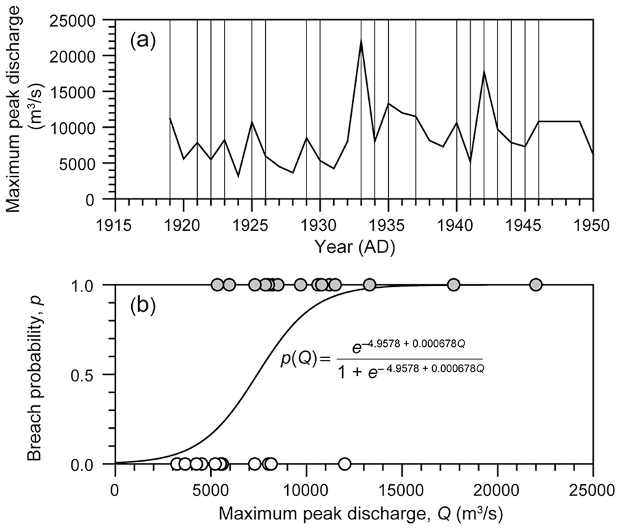
Probabilistic response of levee failure to peak discharge prior to the era of large dam construction on the Yellow River. (a) Annual maximum peak discharge at the Shanxian gauging station. Vertical lines denote the timeline of levee breaches. (b) Logistic regression model. Filled and open circles denote the presence and absence of breaches, respectively.
Long-term trend in the frequency of levee breaches
Our compiled documentary record of levee breaches on the lower Yellow River exhibits remarkable variability not only in the intensity (Figure 2a), but also in the frequency (Figure 3) during the last 2000 years, which can be divided into five stages, corresponding to the major avulsion cycle of the river channel. Smoothing this record using the LOESS method with a span parameter of 0.8 reveals a trend of increasing frequency of levee breaches during this period (Figure 6a). Specifically, the breach frequency remained extremely low during the first half of Stage I and it began to increase slightly from ca. AD 500. An accelerated rise in the breach frequency occurred from AD 893.
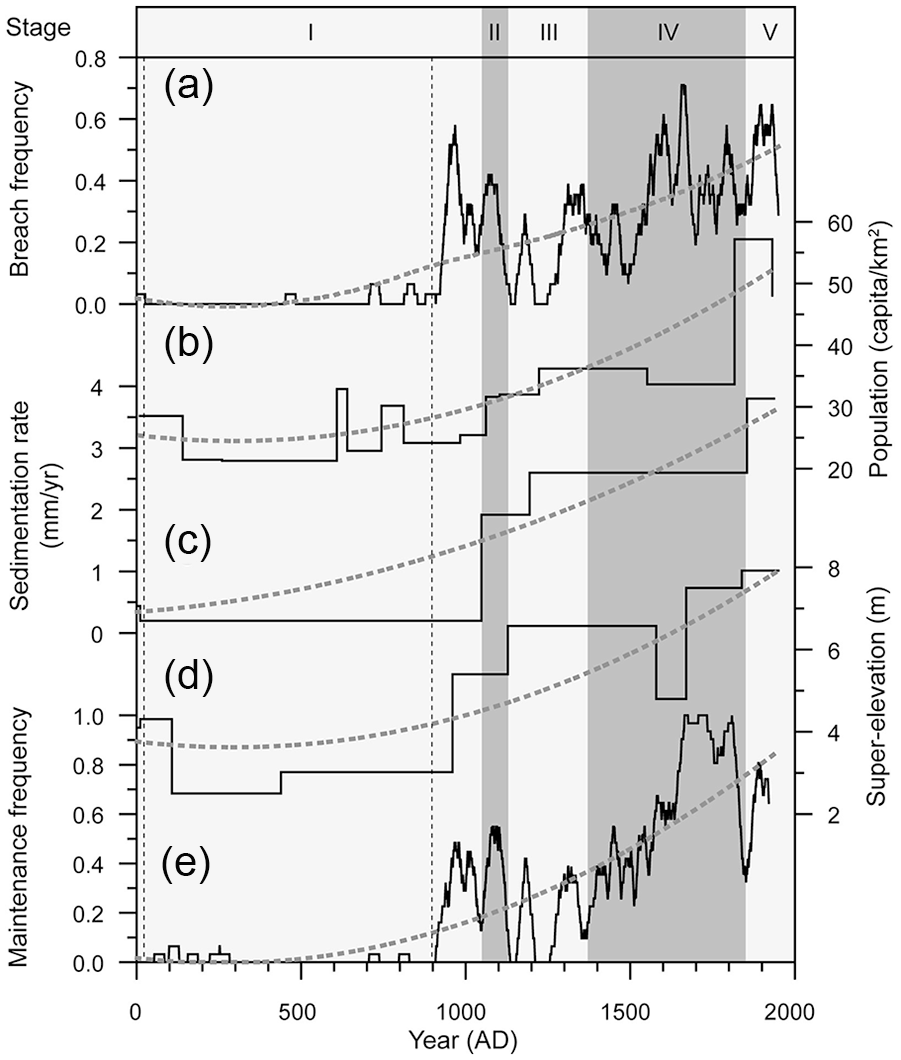
Comparison of levee breaches on the lower Yellow River with human activities and channel parameters during the last 2000 years. (a) Breach frequency. (b) Population density over the Chinese Loess Plateau (Yang, 1993). (c) Channel aggradation rate (Xu, 2003). (d) Modeled super-elevation of channel bed (Chen et al., 2015). (e) Levee maintenance (Shen et al., 1935). Heavy dotted lines are the LOESS curve that highlights the trend, light vertical dashed lines denote the prolonged slack in breaching between AD 11 and AD 893, and shaded vertical bands indicate the major channel stages: I = AD 11–1048, II = AD 1048–1128, III = AD 1128–1368, IV = AD 1368–1855, and V = AD 1855–present.
Discussion
Driving forces of the increasing trend of levee breaches
Our analyses reveal that breaches on the levee of the lower Yellow River became more and more frequent during the last 2000 years (Figure 6a). This trend can be attributed two factors: (1) the increasing population load on the highly erodible Chinese Loess Plateau and (2) the inappropriate management of the river channel. The Chinese Loess Plateau in the middle reaches of the Yellow River covers an area of ca. 0.28×10⁶ km2, accounting for nearly 50% of the total watershed of the Yellow River. The loess has a loose structure and thus highly erodible. Although annual precipitation on the Chinese Loess Plateau is only 400–500 mm, the rainfall is concentrated in the summer months. In the rainy season, heavy rainstorm often occurs. Therefore, it is the largest source of sediments and flood runoff of the Yellow River. A compilation of historical population size in the middle river basin based on household registration data shows a progressive population growth during the last 2000 years (Figure 6b), suggesting that human activities may have played a dominant role in the trend of increasing frequency of breaches through altering the forest cover and land-use pattern over the Chinese Loess Plateau (Xu, 1998). The Eastern Han Dynasty (AD 25–220) and the subsequent Northern and Southern Dynasties (AD 420–589) as well as the Five Dynasties and Ten Kingdoms (AD 907–979) are the three relatively long periods of high political and social turmoil; the population density on the Chinese Loess Plateau was relative low and the economic mode is mainly based on animal husbandry, which had less impacts on forest cover and soil erosion over the Chinese Loess Plateau. Therefore, the in-channel sedimentation rate was extremely low (Figure 6c). Although embankment may have started as early as in the Western Han Dynasty (202 BC– AD 9) (Kidder et al., 2012a, 2012b), the super-elevated channel belt was not formed yet and it is only ca. 2.5 m above its adjacent floodplain (Figure 6d). Breaches occurred occasionally and not so many levee repairs were conducted (Figure 6e).
The prolonged slack in breaching terminated at AD 893 as a result of increasing population density over the Chinese Loess Plateau (Yang, 1993). The increasing population pressure resulted in extensive land reclamation for agriculture in North China (Zhu, 1991). Farming expanded to the steeper slopes of the Chinese Loess Plateau and the northern boundary of the farming-pastoralism transitional zone shifted toward the Great Wall during the North Song Dynasty (AD 960–1128). The upstream erosion and downstream siltation resulted in a rapid aggradation of the river channel from ca. AD 1050 (Figure 6c). The super-elevation exceeded the 5 m threshold of avulsion for the first time (Chen et al., 2015), leading to frequent breaches and levee repairs (Figure 6e). Historical documents show that many forests and grasslands on the Chinese Loess Plateau were cleared and converted to croplands during the Ming and Qing Dynasties (AD 1368–1911) (Zhu, 1991). The anthropogenic deforestation and agricultural expansion enhanced soil erosion and increased sedimentation rate in the channel (Figure 6c), then the channel continued to aggrade (Figure 6d), making the levee prone to breaching (Figure 6e). After the breach, the levee was repaired and heightened to keep up with the rising channel belt, causing further increase in the frequency of breaches. This interactive embankment-siltation-breach process forms a positive feedback.
It appears that human activities have played a pivotal role in the initiation and operation of this feedback. Analyzing historical documents revealed that the intensity of the interactions among embankment, channel siltation, and levee breach may change with time, depending on the strategy and ability of humans to control the sediment loads of the river (Chen et al., 2011). If the focus of river management is only limited to closing the breaches, human activities can enhance the positive feedback. However, if the management also serves to improve the drainage capacity of the river through measures such as upstream soil and water conservation and regular channel dredging, the positive feedback may be weakened. For example, during the reign of Kangxi Emperor of the Qing Dynasty (AD 1661–1722), there were major advances in river management and annual levee maintenance was effectively implemented (Figure 6e). Meanwhile, various hydraulics measures such as dredging, reduction dikes, spillway, desilting, and warping were taken to improve the drainage capacity of the channel (Shen et al., 1935). Although soil erosion over the Chinese Loess Plateau and the in-channel sedimentation rate remained relatively high (Figure 6b and c), the average frequency of levee breaches decreased to 0.3 (Figure 6a), suggesting that proactive and effective river managements do can reduce the risk of breaches.
In addition to breach frequency, the breach intensity was also closely related to human activities and channel parameters. We calculated breach intensity by counting the total number of years in each of which more than two breaches occurred during the five channel stages while the river flowed northwards and southwards relative to the present-day channel location. Similarly, levee maintenance intensity was defined by the total number of years that more than two repairs were made annually. Our correlation analyses reveal a positive relationship of breach intensity with human activities, channel parameters, and river management (Figure 7). For example, breach intensity is positively correlated with population load on the Chinese Loess Plateau (Figure 7a), in-channel sedimentation rate (Figure 7b), channel super-elevation (Figure 7c), and levee maintenance intensity (Figure 7d). Large rivers and their catchment appear to be a coupled system (Hurst et al., 2019), which is sensitive to anthropogenic disturbance (Best, 2019; Lugeri et al., 2019). The Yellow River represents an exceptional example for understanding the interactions of humans and the fluvial system (Chen et al., 2012). Our results suggest that humans played a pivotal role in driving the variations of this system during the last 2000 years through a complicated feedback as described above.
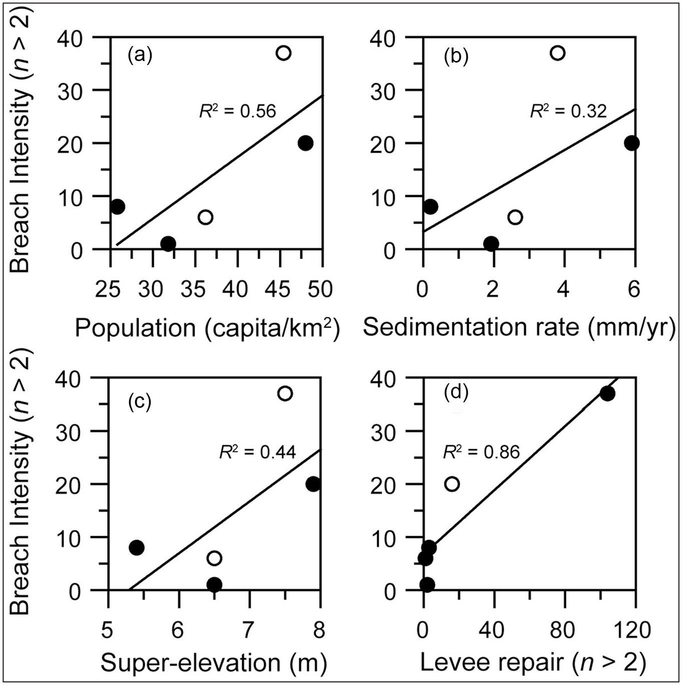
Correlation of breach intensity with human activities and river parameters. (a) breach intensity versus population. (b) Breach intensity versus sedimentation rate. (c) Breach intensity versus channel elevation. (d) Breach intensity versus river management. Filled and open circles denote channel stages of northward and southward flowing relative to the present-day channel position, respectively.
Role of climate changes and river management in the centennial-scale variability of levee breaches
Our record demonstrates variations of the breach frequency on centennial time scales superimposed on a long-term trend (Figure 8a); the timescale of this variability may be determined by patterns of climate (Li et al., 2020). Previous studies also demonstrated that climate changes have played an important role in levee breaches on the lower Yellow River at shorter time scales. For example, a high-resolution dated speleothem δ18O proxy record from the Wuya cave on the southwestern margin of the Chinese Loess Plateau (around 400 km southwest of the Yellow River) revealed a significant quasi-50 year periodicity of precipitation variation in the middle reaches of the Yellow River during the last 370 years (Tan et al., 2014). This cyclic pattern of changes in regional precipitation is highly coherent with the tree-ring based annual rainfall reconstruction of the middle Yellow River area (Liu et al., 2013). Particularly, the three major natural breaches on the lower Yellow River during the last 200 years (i.e., AD 1841 and 1843 at Xiangfu, 1855 at Tongwaxiang, and 1887 at Zhengzhou) correspond with the highest recorded rainfall in the speleothem record. The high runoff of the Yellow River during this period was a prerequisite for these events, revealing the importance of rainfall changes over the Chinese Loess Plateau on the Yellow River channel security.
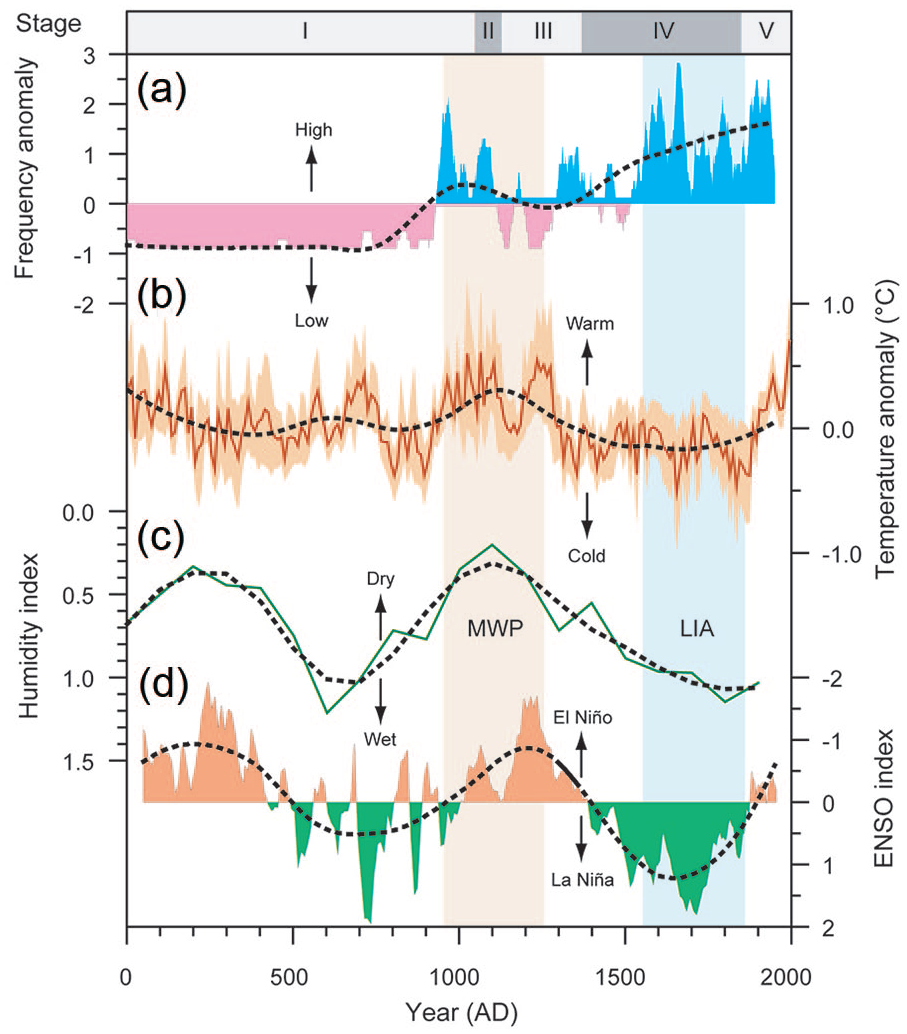
Comparison of levee breaches on the lower Yellow River with climatic factors. (a) Frequency anomaly of breaches. (b) Temperature anomaly over China (Ge et al., 2013). (c) Humidity index in the middle Yellow River basin (Xu, 2003). (d) Reconstructed El Niño-South Oscillation (ENSO) index (Yan et al., 2011). Vertical bands highlight persistent climate anomalies corresponding to the Medieval Warm Period (MWP) and the Little Ice Age (LIA) and heavy dotted lines indicate centennial-scale fluctuations detected using the LOESS smoothing method with a span parameter of 0.4. Major channel stages: I = AD 11–1048, II = AD 1048–1128, III = AD 1128–1368, IV = AD 1368–1855, and V = AD 1855–present.
To better understand the impact of climate changes on levee breaches at a longer time scale, we first calculated the frequency anomaly of breaches by normalizing our record and then compared the record with the reconstructed temperature anomaly in China relative to the 1851–1950 climatology (Figure 8b), humidity index in the Chinese Loess Plateau (Figure 8c), and ENSO index (Figure 8d). The temperature record is based on partial least squares regression of proxy temperature data at a decadal resolution from five regions across China as well as instrumental data covering the period from AD 1871 to 2000 (Ge et al., 2013). While precipitation record covering the last 2000 years in this region is lacking, we used the humidity index, which is based on the number of historical flood and drought disasters in the middle Yellow River area (Xu, 1957). Our record shows that the frequency of breaches was extremely low prior to ca. AD 950 (Figure 8a). The low breach frequency is partly due to lack of data particularly during AD 304–439 when this area was occupied by the nomadic people. However, the low breach frequency during ca. AD 450–950 corresponds well to a relatively cold (Figure 8b) and wet period (Figure 8c). Such a climate condition may have reduced evaporation and increased soil moisture of the Chinese Loess Plateau, thereby making the catchment resistant to erosion. Frequent breaches prevailed during most part of the Medieval Warm Period (AD 950–1250). The relatively warm and dry climate may have preconditioned the Chinese Loess Plateau to be vulnerable to erosion, which in turn enhanced channel siltation and elevated the risk of breaches.
Comparing our record with the reconstructed climate records reveals centennial-scale variability of breach frequency in phase with climate changes prior to ca. AD 1250. This coherence was probably modulated by the irregular periodical variation in the wind and sea surface temperature patterns over the tropical eastern Pacific Ocean, known as El Niño/Southern Oscillation (ENSO), which is closely linked to hydrological changes in the large river systems of the world (Ward et al., 2014a, 2014b). For example, the warm phase of ENSO (i.e., the El Niño state) can increase the flood risk of the lower Mississippi River by generating a positive precipitation anomaly that increases surface water storage and reduces soil infiltration capacity (Munoz and Dee, 2017). In the Yellow River basin, instrumental data showed that the inter-annual variability of the Yellow River discharge also tends to align with the ENSO cycle (Wang et al., 2006). Specifically, during warm ENSO phases, the East Asian summer monsoon is weakened and the western Pacific Subtropical High moves southward, which leads to a decrease in rainfall in the Chinese Loess Plateau. Conversely, during an ENSO cold phase (i.e., the La Niña state), the East Asian summer monsoon strengthens and the western Pacific Subtropical High s pushes northward, causing the rain belt to persist for longer in the Chinese Loess Plateau and thus an increase in rainfall. Fitting our data with the exponential distribution yields a mean time interval of 3.5 years between each two consecutive breaches (Figure 2c). This is a typical frequency band of ENSO (Kestin et al., 1998), implying the impact of ENSO on levee breaches at a shorter time scale. Recent studies also showed that the lower Yellow River bank breaching is closely related to La Niña events (R2 = 0.5 and p = 0.046) during the last 1000 years (Xu and Li, 2019). The synchronous variations of breach frequency with the reconstructed ENSO index (Figure 8d) suggest that ENSO played a pivotal role in centennial-scale variability of breach frequency through regulating soil moisture and erodibility in the Chinese Loess Plateau.
In contrast to the in-phase variations between breach frequency and climate prior to ca. AD 1250, our record shows an increasing frequency of breaches out of phase with climate changes after the termination of the Medieval Warm Period (Figure 8a). Specifically, the frequency of breaches began to increase from AD 1250 in the face of a relatively cold (Figure 8b) and wet (Figure 8c) climate during the Little Ice Age when an ENSO cold phase prevailed (Figure 8d). This aberrant phase relationship suggests that humans began to play a dominant role over climate in the hydromorphological changes of the lower Yellow River during the last 1000 years while the main river channel shifted southwards and discharged to the Yellow Sea (Figure 4c and d). The human impacts on breaches are two folds: (1) Enhancing soil erosion over the Chinese Loess Plateau. Reconstructed sediment discharge shows a substantial increase from ca. AD 1000 (Wu et al., 2020), corresponding to the increasing population load in the Chinese Loess Plateau (Figure 6b). In order to keep up with the aggravating channel siltation (Figure 6c), the levee was heightened progressively and a super-elevated channel belt was formed eventually (Chen et al., 2011); (2) Improper river management. The super-elevated channel belt preconditioned the levee to be prone to breaching particularly during times of large floods (Figure 5b). Once a breach occurred, closing the breach is a routine strategy followed by the local authority. The frequent levee repairs (Figure 6e) kept more and more sediments within the channel, which in turned increased the super elevation and enhanced the positive feedback as discussed above. Our study provides an additional example from a large river in Asia and confirmed the studies elsewhere, suggesting that river engineering can amplify the climate-controlled flood frequency (Criss and Shock, 2001; Pinter, 2005; Munoz et al., 2018).
Relationship between levee failure and large floods
Levee failure is a transient process typically involving four key elements (Chen et al., 2011): (1) an elevated channel bed compared to the surrounding floodplain. This setting would facilitate channel aggradation as the sediment-carrying capacity of the channel becomes smaller than the sediment inflow; (2) a low channel capacity. This setup would reduce the bankfull discharge and increase the extent of overspill; (3) a peak discharge event that lasts for several days. The sudden rise of water level in the channel would yield enough lateral stress along the levee to trigger a breach; and (4) a weakened river bank. The bank tends to destabilize during a peak discharge event and it is likely to fail particularly in weak sections. However, the relative importance of these factors varies, depending on the time scale. Multivariate regression analysis revealed that channel capacity is an important factor in levee failure at the decadal time scale (Chen et al., 2011), however, our modeling shows that large flood appears to be a dominant factor at the annual time scale (Figure 5).
Although a positive relationship between breach probability and peak discharge exists (Figure 5), quantifying the magnitude of peak discharge for a historical levee breach event is impossible, because the breach depends on not only the magnitude of the flood, but also other factors in the drainage basin (Xu, 2001), particularly when the river was subject to extensive management and regulation. For example, instrumental data showed that there has been a total of eight breach years when flash floods with a peak discharge exceeding 10000 m3/s occurred during the period of AD 1911–1946 (Figure 5a). However, due to the extensive channel dredging, levee maintenance, and dam constructions since AD 1949, no levee breaches occurred even though as many as 12 floods with a peak discharge >10000 m3/s occurred since then. For example, a large flood broke out on August 2, 1982 with a peak discharge of 15300 m3/s measured at the Huayuankou gauging station (Figure 1), but no levee breaches occurred on the lower Yellow River. Therefore, large floods appear to be a prerequisite for breaches. Our results suggest that historical data of levee breaches can be used as a valid proxy of large floods (with a peak discharge of at least 7000 m3/s) in the past (Li et al., 2020).
Implications and conclusions
We present a unique long-term documentary record of levee breach events on the lower Yellow River during the last 2000 years. Our results show that the frequency of levee breaches varied remarkably at different time scales, which can be subdivided into five stages generally corresponding to the avulsion cycle of the river. There is a long-term trend of increasing breach frequencies, which is essentially induced by the embankment-siltation-breach feedback. The intensity of human activities and the level of river regulation played a vital role in the formation and operation of this loop. Superimposed on a long-term increasing trend, the frequency of breaches also exhibits centennial-scale variability. Comparing our record with the reconstructed temperature and humidity records reveals a high coherence of levee failure with climate changes prior to AD 1250, most likely modulated by the ENSO cycle at this time scale. Humans began to play a dominant role in the breach frequency over climate changes since then.
Our study demonstrates how humans and climate changes modulated the variations of breach frequency on one of the world’s large rivers, which have several implications for river management: (1) Effective soil conservation and vegetation restoration on the Chinese Loess Plateau is essential for reducing the upstream erosion, which in turn may attenuate the embankment-siltation-breach feedback; (2) Embankment is an improper river engineering that may amplify breach frequency. Future work of river management should focus on channel dredging, which represents an appropriate measure to break the positive feedback of embankment, channel siltation, and levee breach; (3) Lowering the super elevated channel belt is the ultimate and most practical need to increase channel security. More attention should be paid on the channel section near Zhengzhou, in which the largest topographical gradient exists and thus the most frequent breaches occurred during the historical period; (4) Breach is a stochastic process with an average waiting time for the next occurrence very close to the ENSO frequency band. Therefore, monitoring ENSO variations may improve the predictive ability to short-term forecasts of breach risk.
Supplemental Material
sj-pdf-3-hol-10.1177_0959683620972764 – Supplemental material for A 2000-year documentary record of levee breaches on the lower Yellow River and their relationship with climate changes and human activities
Supplemental material, sj-pdf-3-hol-10.1177_0959683620972764 for A 2000-year documentary record of levee breaches on the lower Yellow River and their relationship with climate changes and human activities by Wen-Jia Li, Shi-Yong Yu, Jianrong Pan, Xianyong Cao, Yingying Chen and Yi Wang in The Holocene
Research Data
sj-xlsx-1-hol-10.1177_0959683620972764 – A 2000-year documentary record of levee breaches on the lower Yellow River and their relationship with climate changes and human activities
sj-xlsx-1-hol-10.1177_0959683620972764 for A 2000-year documentary record of levee breaches on the lower Yellow River and their relationship with climate changes and human activities by Wen-Jia Li, Shi-Yong Yu, Jianrong Pan, Xianyong Cao, Yingying Chen and Yi Wang in The Holocene
Research Data
sj-xlsx-2-hol-10.1177_0959683620972764 – A 2000-year documentary record of levee breaches on the lower Yellow River and their relationship with climate changes and human activities
sj-xlsx-2-hol-10.1177_0959683620972764 for A 2000-year documentary record of levee breaches on the lower Yellow River and their relationship with climate changes and human activities by Wen-Jia Li, Shi-Yong Yu, Jianrong Pan, Xianyong Cao, Yingying Chen and Yi Wang in The Holocene
Footnotes
Acknowledgements
We thank Dr. Lucy Clarke for her constructive comments and suggestions that greatly improved the manuscript. Our gratitude is also extended to Prof. Quansheng Ge for providing us with the data of reconstructed temperature anomaly in China over the past 2000 years.
Funding
The author(s) disclosed receipt of the following financial support for the research, authorship, and/or publication of this article: Yu’s work was supported by the National Science Foundation of China (Grant no.: 41971102) and the Priority Academic Program Development of Jiangsu Higher Education Institutions while Chen’s work was supported by the National Science Foundation of China (Grant no.: 41701101).
Supplemental material
Supplemental material for this article is available online.