
Abstract
Palynological data from three radiocarbon dated peat profiles at Rishworth Moor in the Pennine hills of northern England provide a record of vegetation change and human impacts in the Late Mesolithic, Neolithic and Bronze Age periods. All three cultures have archaeological sites present in the vicinity, with Late Mesolithic sites by far the most abundant, comprising mainly very late assemblages dominated by ‘rod’-shaped microliths. Pollen evidence of vegetation disturbance occurs during all three archaeological periods, and is attributed to the results of human activity. Microscopic charcoal and non-pollen palynomorph analyses support the pollen evidence. Sites at Cat Stones 2 and Cat Stones 3 record evidence of Neolithic and Bronze Age date only. Cat Stones 1 extends into the Late Mesolithic period, and fine-resolution pollen analyses have been applied in this profile to the Mesolithic–Neolithic transition leading up to the mid-Holocene Elm (Ulmus) Decline, which starts here at c. 4940 14C BP (5670 cal. BP), a typical date for it in the central Pennines. Bayesian age-depth modelling provides precise ages for the vegetation changes and their spatial correlation. The plateau was dominated by scrub and grassy Calluna heath from the Late Mesolithic onwards. Elevated microscopic charcoal levels and ruderal herb pollen record phases of fire disturbance below the Elm Decline, including a grain of Hordeum cereal-type. Whether this grain represents early cultivation requires further research. Bronze Age impacts are of greater intensity, but disturbances of all three cultural periods are low scale, agreeing with the results of previous research in the Pennines.
Keywords
Introduction
In Britain the later mid-Holocene, between about 5500 and 3700 radiocarbon years ago (c. 6300 to c. 4000 cal. BP), contained important environmental and cultural transitions. Deciduous woodland was the natural vegetation, its composition varying with environmental factors (Bradshaw and Hannon, 2004). In the central Pennines hills of northern England the mid-Holocene woodland’s upper limit was at c. 500 m above sea level, based on macrofossil tree remains (Tallis and Switsur, 1983, 1990), above which was scrub, bog and moorland, the ‘hyper-forest zone’ of Simmons (1975). As well as naturally open areas (Brown, 1997; Fyfe, 2007), mainly wetlands, millennia of disturbance by Mesolithic hunter-gatherers’ use of fire might have affected woodland density and composition, encouraging heliophyte trees and shrubs and creating an open woodland with temporary clearings (Caseldine and Hatton, 1993; Jacobi et al., 1976; Simmons and Innes, 1987). Long-term burning by foragers might have changed the woodland’s nature and sometimes even converted it to grassland, heathland or bog (Moore, 1975; Moore et al., 1984; Simmons 1996; Simmons and Innes, 1985, 1987). Climate fluctuations during this time were important, with dry conditions before 6000 cal. BP, then wet phases at c. 5900, c. 5300 and after 4400 cal. BP, with intervening dry periods (Hughes et al., 2000; Stolze et al., 2012; Tipping, 1995, 2010). Climatic fluctuations were influential in regulating vegetation patterns and affecting human responses (Bonsall et al., 2002; Schulting, 2010; Tipping, 1996, 2010; Tipping and Tisdall, 2004). Burning during dry phases could have had a natural cause, and not all woodland disturbances need have had an anthropogenic origin (Grant et al., 2014).
During this period major cultural transitions took place. One was the change from foraging (Mesolithic) to farming (Neolithic) economies and culture, occurring in the centuries leading up to and including the major decline in Ulmus (Elm) pollen frequencies that forms a key biostratigraphic marker dated to broadly 5100 radiocarbon years ago (c. 5800 cal. BP, Parker et al., 2002) in pollen diagrams. The range of radiocarbon dates for the Elm Decline in northern England is considerable (Griffiths, 2014a), from 5468±80 BP (6410-6004 cal. BP) at Neasham Fen in southeast Durham (Bartley et al., 1976) to 4644±43 BP at Bonfield Gill on the North York Moors (Innes and Blackford, 2017; Innes et al., 2013). It was multi-causal (Parker et al., 2002), with disease, Neolithic farming and climate change all contributory factors. It coincided with an early stage in the Neolithic, with significant elements of Neolithic culture and economy present. However, with a dating variability of several centuries over short distances, it is unlikely that it can be interpreted as marking the first introduction of the Neolithic to a particular location. While the ‘full’ post-Elm Decline Neolithic was established by immigrant farmers (Sheridan, 2010), there might have been an ‘initial Neolithic’ before the Elm Decline, with Neolithic elements added to the Mesolithic culture. When that occurred would have varied from place to place (Noble, 2010). The second major cultural transition was the change from Neolithic to Bronze Age, taking place around 4000 radiocarbon years ago (c. 4500 cal. BP), and marking the introduction of a more technologically advanced farming society. The replacement of Neolithic populations by immigrating groups accompanied this change (Olalde et al., 2018), after which Bronze Age agriculture and land use expanded under a congenial climate (Tipping, 2005). While the Mesolithic-Neolithic and Neolithic-Early Bronze Age transitions are clearly visible in material culture changes, transformations that occurred in human relations with the land and environment are less so.
We present palynological evidence for land-use and environmental changes through the later Mesolithic, Neolithic and Bronze Age on the high-altitude watershed of the Central Pennine hills, probably marginal for early agriculture in terms of climate, soils and vegetation in the mid- to late Holocene (Tipping, 2002; Young, 2000; Young and Simmonds, 1995). The research aims are (a) to investigate the mid- to later Holocene vegetation of this upland, and to establish whether and to what degree its natural vegetation successions were disturbed, and (b) were any disturbances caused by human land use and if so, was early agriculture involved. Three pollen profiles are analysed, providing spatially comparable data for a better understanding of the transitions into and out of the Neolithic. Fine-resolution palynology is used through the pre-Elm Decline levels to study the Mesolithic–Neolithic transition in detail.
Materials and methods
The study area
Rishworth Moor is a flat plateau over 400 m above sea level on the watershed of the Central Pennines to the northeast of Manchester (Figure 1). The plateau is covered by shallow blanket peat, with deeper peat in depressions and in channels at spring heads, where older sediments are preserved. Rishworth Moor has been the subject of previous palynological research (Bartley, 1964, 1975). Current vegetation comprises heath plants Calluna vulgaris and other Ericaceae, with Eriophorum vaginatum, Molinia caerulea and Sphagnum spp. in wetter areas. Rarely, wood fragments are present at the base of the peat. The Central Pennines (Figure 1, Section B) contains many archaeological sites (Manby, 1986; Manby et al., 2003; Petch, 1924) and was well exploited by prehistoric communities. Neolithic and Bronze Age sites are mainly located (Figure 1, Section B) on the lower moors although some occur on the southern edge of Rishworth Moor. Neolithic remains are mainly isolated finds of polished stone axes or leaf-shaped arrowheads (Barnes, 1982). Bronze Age sites are more diverse, including burial monuments, metalwork, pottery, circular enclosures and rock art, indicating a significant occupation of the landscape. Late Mesolithic sites (Barnes, 1982; Wymer, 1977) are abundant at altitude (Figure 1, Section B), and Rishworth Moor lies within the main Pennine distribution area for Late Mesolithic flint microliths (Keighley, 1981; Preston, 2013a, 2013b; Preston and Kador, 2018; Radley et al., 1974; Spikins, 1999; Stonehouse, 1987; Switsur and Jacobi, 1975; Wymer, 1977). These flint scatters were temporary hunting camps within a larger hunter-gatherer territory (Preston, 2013a, 2013b). Mesolithic flint sites occur on and around Rishworth Moor itself (Wymer, 1977), including near Cat Stones (Figure 1, Section C). Some are dominated by ‘rod’ shaped microliths. Although rods occurred throughout the late Mesolithic, rod-dominated flint sites are a late variant assemblage (Griffiths, 2014b) representing occupation near the very end of the Mesolithic (Spikins, 2002). Near Rishworth Moor, rod sites have radiocarbon dates on hearth charcoal as late as 5190 ± 30 BP (5993–5910 cal. BP), 5255 ± 30 BP (6178–5929 cal. BP) and 5270 ± 45 BP (6183–5934 cal. BP) at March Hill Top (Spikins, 2002) and 5380 ± 80 BP (6306–5948 cal. BP) at Dunford Bridge (Switsur and Jacobi, 1975). These two sites, and other sites mentioned in this paper, are located on Figure 2. Griffiths (2014b) calculates that rod microlith use ended in the Pennines between 5900 and 5490 cal. BP, and the Neolithic started between 5870 and 5670 cal. BP. The earliest Neolithic dates in the area are 5185 ± 60 BP (6180–5750 cal. BP) at Fox Hole Cave (Hellewell and Milner, 2011) and 5380 ± 90 BP (6313–5938 cal. BP) at Whitwell Long Cairn (Hedges et al., 1994). Some rod sites were therefore contemporaneous with the earliest Neolithic sites, suggesting temporal overlap and cultural coexistence (Griffiths, 2014a, 2014b; Keighley, 1981), probably utilising different parts of the landscape. The environmental context of rod sites is of great interest regarding the palaeoecology of the Mesolithic–Neolithic transition (Albert and Innes, 2015). The transition from Neolithic to Bronze Age in the area occurred around 4450 cal. BP, confirmed by a late Neolithic date of 4060 ± 130 BP (4858–4159 cal. BP) at Castle Hill and an early Bronze Age date of 3865 ± 40 (4420–4150 cal. BP) at Lindley Moor (Manby et al., 2003). Both sites are only 10 km to the east of Rishworth Moor.
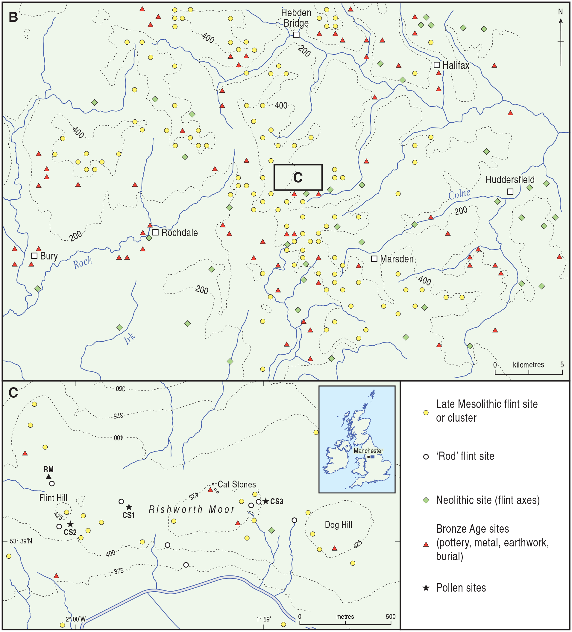
Map showing the location of Rishworth Moor (Section C) within the Central Pennine Hills (Section B). The distributions of archaeological sites are derived from Wymer (1977) and Barnes (1982) and are not comprehensive, showing main sites only. Site symbols are shown as open circles (Late Mesolithic sites dominated by rod microliths in Section C), yellow circles (other Late Mesolithic sites), green diamonds (Neolithic) and red triangles (Bronze Age). In Section C the three Cat Stones pollen diagrams are shown as black stars and labelled CS1–CS3. The previously published pollen site of Bartley (1975) is shown as a black triangle and is labelled RM. Contours are in metres above mean sea level.
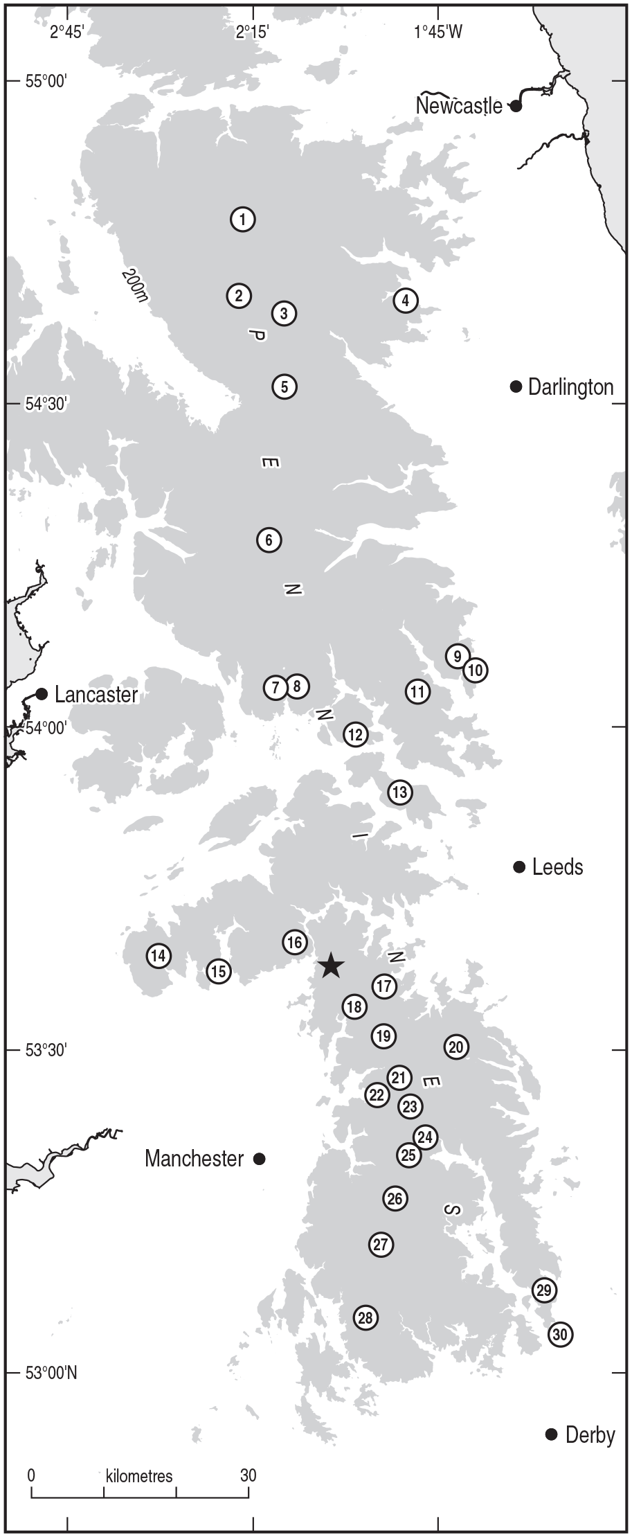
Locations of the Pennine sites mentioned in this paper, sources are cited in the text. 1. Quick Moss 2. Mire Holes 3. Valley Bog 4. Pawlaw Mire 5. Gate Gutter 6. Fleet Moss 7. Malham Tarn Moss 8. Great Close Pasture 9. Fountains Earth 10. Skell Moor 11. Stump Cross 12. Eshton Tarn 13. Lanshaw 14. Black Brook 15. Deep Clough 16. Soyland Moor 17. Black Heath 18. March Hill Top 19. Rocher Moss 20. Dunford Bridge 21. Robinson’s Moss 22. Tintwistle 23. Bleaklow 24. Alport Moor 25. Lady Clough Moor 26. Featherbed Moss 27. Kinder 28. Lismore Fields 29. Totley Moss 30. Leash Fen. The black star is the location of Rishworth Moor.
The research sites
The peat on Rishworth Moor is mostly shallow, but some deeper areas are present and three of these were selected for analysis, at Cat Stones (CS) 1 (SD994172), 2 (SD990172) and 3 (SD999173). All three sites lie between 410 and 420 m above sea level. Their locations are shown on Figure 1, Section C, as is the site of Bartley (1975) near Flint Hill. These sites were in sub-peat depressions, and were chosen to be near to rod sites. Site CS1 contained 2 m of peat, but CS2 and CS3 both contained less than a metre. The three cores were collected using a Russian peat borer.
Laboratory methods
The basal parts of the profiles were analysed with varying degrees of fine-resolution sampling. Most of the CS2 sediment was sampled at 1 cm intervals, increasing to 2 cm near the top of the sampled core. The base of the CS1 sediment, which covers the terminal Mesolithic to early Bronze Age, comprised very well humified amorphous peat and was sampled at 5 mm intervals, as was the base of the CS3 profile. The peat from the base of CS1 up to just before the Elm Decline represents the Mesolithic–Neolithic transition and was sampled at contiguous 1 mm slices. Laboratory preparation followed standard procedures (Moore et al., 1991) using KOH and acetolysis, with HCL and HF in samples with a mineral content. Silicone fluid was used to mount the pollen residue on microscope slides. Pollen identifications and nomenclature follow Moore et al. (1991), except that Poaceae is used rather than Gramineae. At least 800 pollen grains were counted at each level. Poaceae grain frequencies are expressed as different long diameter size-class curves to assist differentiation of grass taxa (Albert and Innes, 2015; Andersen, 1979; Joly et al., 2007), such as Glyceria, which can be differentiated from Hordeum (Albert and Innes, 2020). Poaceae between 22 and 24 µm include the wetland taxa Phragmites, Deschampsia and Molinia, those between 25 and 27 µm represent Nardus (Andersen, 1979), those between 28 and 30 µm represent Glyceria maxima, and those greater than 30 µm that are not of Hordeum type represent Glyceria fluitans. Most Poaceae grains recorded were less than 30 µm. Pollen frequencies have been calculated as percentages of a total land pollen sum which comprises trees, shrubs and herbs.
NPPs (non-pollen palynomorphs) were identified using the catalogue developed at the Hugo de Vries Laboratory, University of Amsterdam (van Hoeve and Hendrikse, 1998) and published illustrations and descriptions (e.g. Miola, 2012; van Geel, 1978, 1986, 2001). A wide range of types was identified in very low values, but only important indicator NPPs are shown on the text diagrams, such as Gelasinospora (HdV-1) as an indicator of burning, and Cercophora (HdV-112) and Sporormiella (HdV-113) as indicators of animal dung (van Geel, 1986). NPPs are expressed as percentages of total land pollen, although not included in the pollen sum. Full NPP diagrams are shown in Supplemental Material, available online. NPPs are shown with the conventional ‘Type’ numbering system (Miola, 2012) as well as their taxonomic identification where possible. Microscopic charcoal particles, which passed through the 180 µm sieve during laboratory preparation, were counted on pollen slides (Robinson, 1984) and expressed as percentages of the total land pollen sum. They are divided into size-classes to assist interpretation regarding their likely distance from fire sources (Blackford, 2000). Seven 5 mm thick samples were AMS 14C dated, comprising bulk peat as levels selected for dating had no terrestrial macrofossils.
Results and interpretation
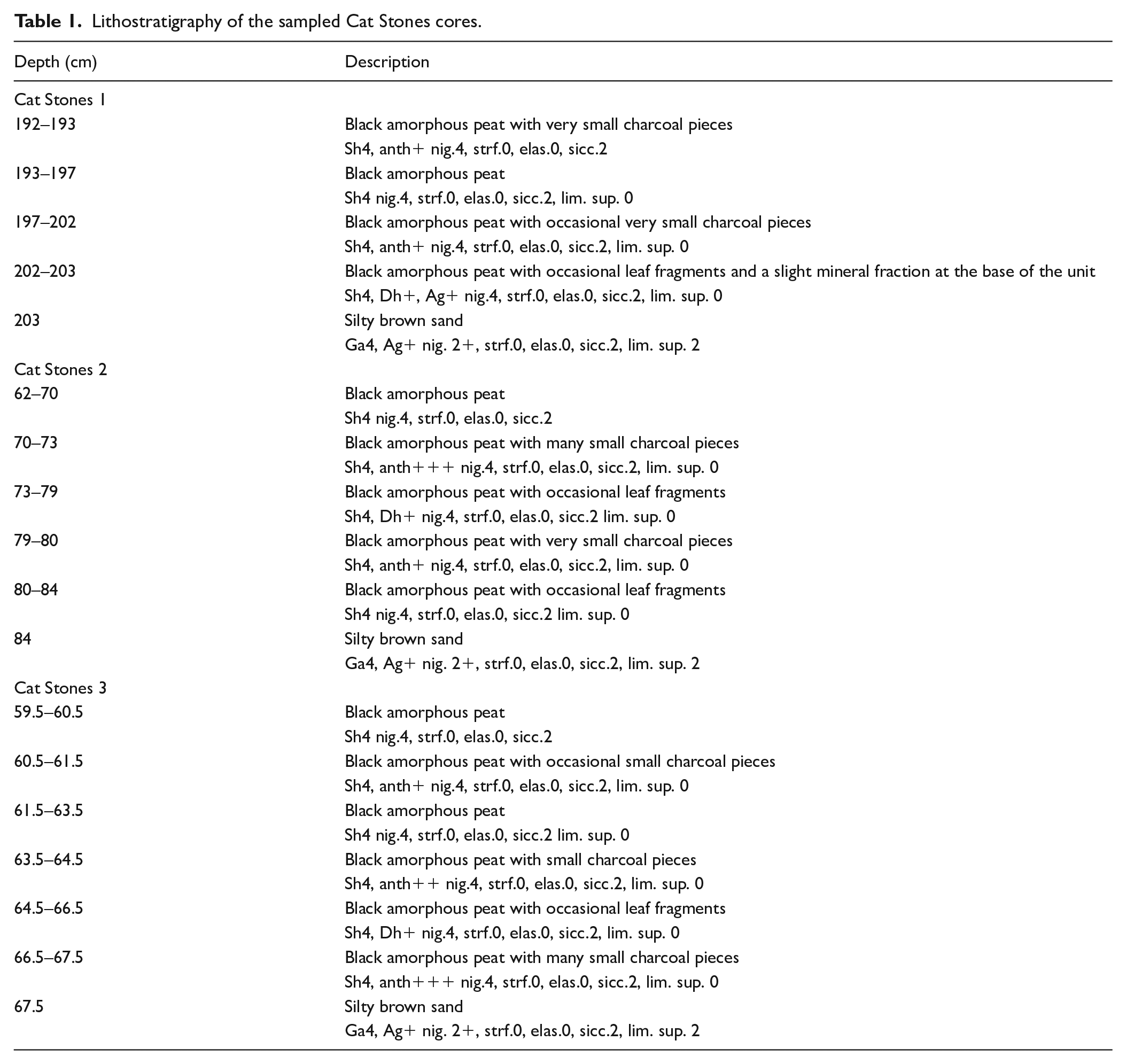
Lithostratigraphy
The lithostratigraphies of the sampled parts of the three cores are similar, comprising completely humified black amorphous peat which overlies brown, inorganic sandy mineral soil. Stratigraphic components of the sampled core sections according to Troels-Smith (1955) are shown as Table 1 and as lithostratigraphic columns on the pollen diagrams. They vary in the presence of small macroscopic charcoal pieces in the peat in each core. The peat is described as Substantia humosa (Sh) as its environment of deposition is uncertain, but the presence of leaf fragments and aquatic pollen and NPPs (Supplemental Material, available online) suggests a partly detrital origin.
Lithostratigraphy of the sampled Cat Stones cores.
Radiocarbon dating
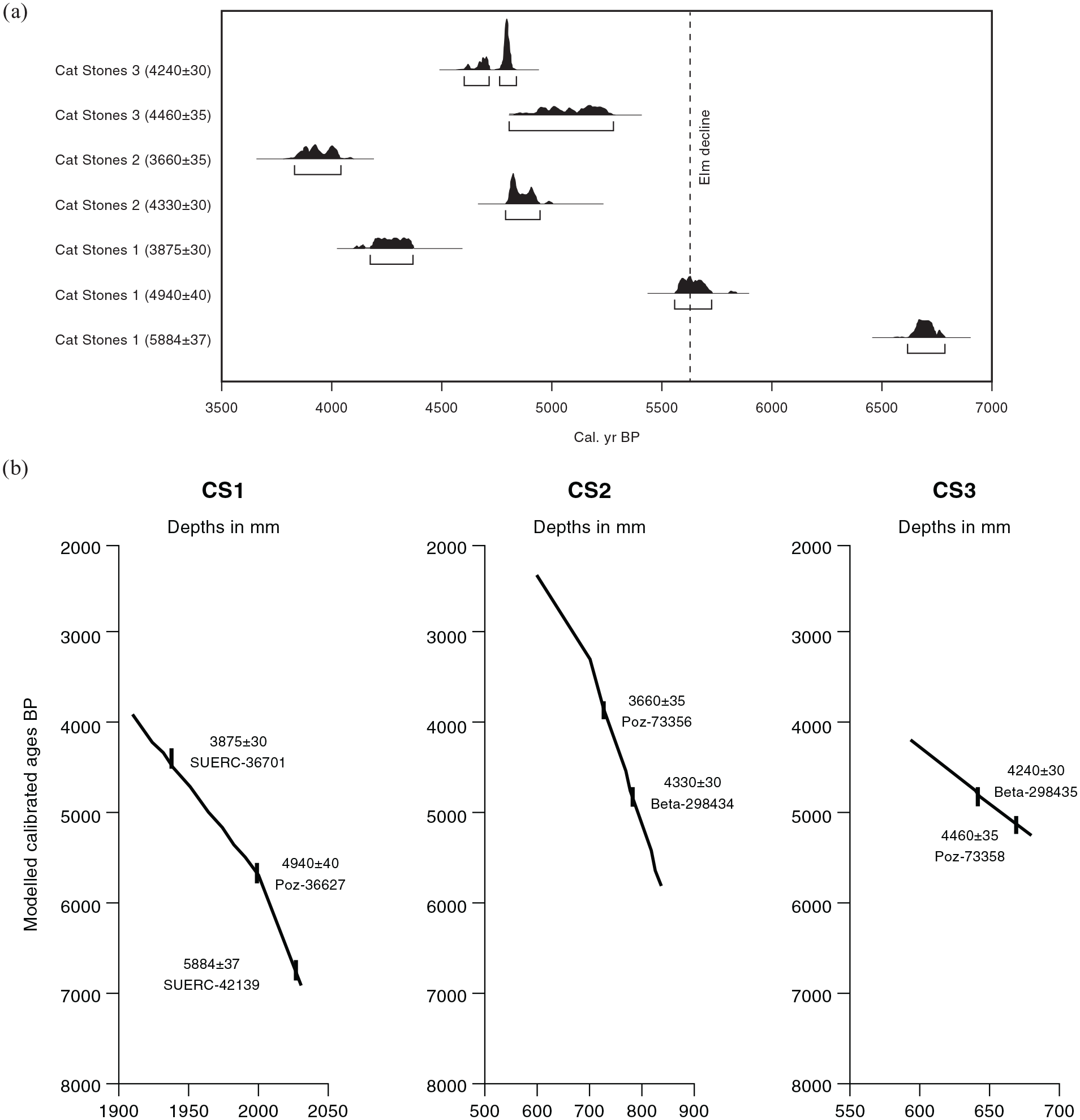
Dating information from the three Cat Stones sites, using Oxcal 4.2 and IntCal13 (Reimer et al., 2013), is presented in Table 2, and the calibrated age range probabilities at the 2δ level are shown in Table 2 and Figure 3a. Three dates are available from Cat Stones 1, and two dates each from Cat Stones 2 and 3. This study covers the basal parts of the profiles, and their mean age-depth model curves are shown as Figure 3b, calculated using Bayesian statistical modelling. A Poisson Sequence was chosen (model parameters: P_Sequence (0.1, 0.4, U(-2,2)) as the most appropriate deposition model as it assumes random deposition, and gives approximate proportionality to depth (Bronk Ramsey, 2008). Age-depth modelled data are shown in Supplemental File S1, available online. The three dates at CS1 appear to be broadly linear (Figure 3a) but the age-depth model (Figure 3b) shows an inflexion in the curve that indicates a doubling in sedimentation rate from c. 400 years per cm below 200 cm depth, to c. 200 years per cm above that point (Supplemental File S1, available online). Nevertheless, the overall rate of peat accumulation at CS1 was very slow for three millennia. Peat accumulation rate at CS2 was c. 225 years per cm, and at CS3 c. 125 years per cm, comparable to the later part of CS1. In all three diagrams the spacing and ages of the available dates suggest no hiatus in peat deposition.
Results of AMS 14C dating at Cat Stones, Rishworth Moor.
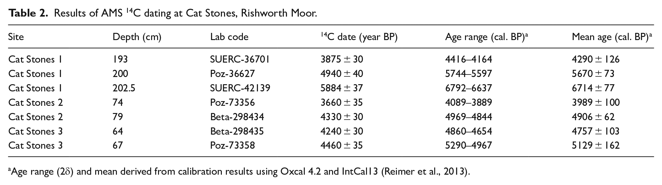
Age range (2δ) and mean derived from calibration results using Oxcal 4.2 and IntCal13 (Reimer et al., 2013).
(a
Palaeogeography
Peat formation began on Rishworth Moor in different places at different times, with a delay of 1 to 2000 radiocarbon years between initial accumulation at Cat Stones 1 and the basal peat at the other two Cat Stones sites. The bases of CS2 and CS3 are not directly radiocarbon dated, but have modelled ages of 5823 and 5253 cal. BP respectively, suggesting a date around the Elm Decline for CS2 and a clearly post Elm Decline age for CS3. Both sites’ pollen assemblages indicate a post-Elm Decline age. The Elm Decline is dated at Cat Stones 1 at 4940 ± 40 BP (modelled 5670 cal. BP). The base of Cat Stones 1 has a modelled age of 6923 cal. BP. The peat profile near Flint Hill on Rishworth Moor (Figure 1) investigated by Bartley (1975) also began to form before the Elm Decline, although probably later than at CS1, as the reliability of Bartley’s very early radiocarbon date of 5490 ± 140 BP for that feature is highly questionable (Griffiths and Gearey, 2017). There was much spatial variability in marsh and peat formation across the plateau, presumably because of topography, peat forming earlier in basins, often around spring heads (Edwards and Hirons, 1982; Tallis, 1973), whether or not the trigger for peat initiation was climatic (Tipping, 1996) or due to post-disturbance paludification (Moore, 1975; Moore et al., 1984). Highly contrasting dates for peat initiation, very slow early growth, and great variability in peat depth, have been noted over short distances elsewhere in the Pennines, as in the Bleaklow and Kinder areas (Conway, 1954) and at Featherbed Moss in Derbyshire (Tallis, 1973). It is likely to be a common feature of the palaeogeography of the Pennine plateaux (Garton, 2017; Tallis, 1991), as in other British uplands (Cundill, 1977; Tallis, 1991; Tipping, 2008). The extremely amorphous and decomposed nature of the lower peat at all the Cat Stones sites indicates very slow organic accumulation. The sites with pre-Elm Decline peat are in shallow depressions between small knolls, whereas post-Elm Decline peat formation took place on more elevated areas. The basin areas were wetlands in pre-Elm Decline times, marshy or holding shallow open water, and might have been attractive locations for human activity (Albert and Innes, 2015). High frequencies of sedge pollen and Typha pollen at the base of Cat Stones 1 support this. Peat accumulation in these basins began very slowly: at Cat Stones 1 several hundred years’ accumulation is present in only a few centimetres of basal peat, and it might well have been the late Neolithic or Bronze Age before the area was fully peat-covered. Records for aquatic pollen of Nymphaea and Typha in most of the three profiles suggest that bog pools and ponds remained present on the Rishworth Moor plateau well into the Bronze Age. Records of diatoms and other freshwater algae such as Zygnema (HdV-58), Mougeotia (HdV-313) and Pediastrum (HdV-760) in the sediment support this (Supplemental Figures S2, S3, S4 and S5, available online).
Palynology
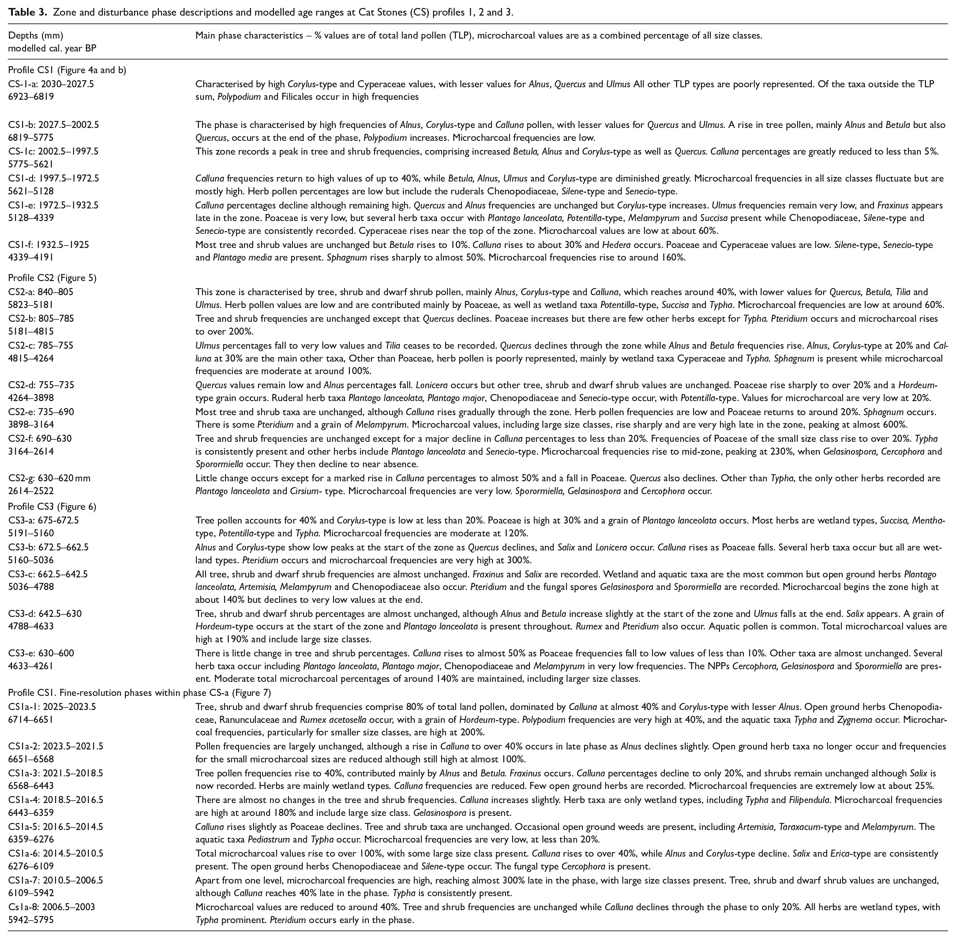
Palynological results at the three Cat Stones profiles are shown in Figures 4–7. For profile CS1, tree and shrub frequencies are shown in Figure 4a, and herb, spore, microcharcoal and selected NPP frequencies are shown in Figure 4b. For profile CS2 pollen and selected NPPs are shown in Figure 5, and those for profile CS3 in Figure 6. The fine-resolution palynology of the pre-Elm Decline phases at CS1 is shown in Figure 7. The diagrams are zoned as disturbance phases in Figure 7 and as pollen assemblage zones in the other diagrams, identified subjectively based on major changes. Descriptions of the zones and phases are given in Table 3, which includes modelled ages derived from Supplemental File S1, available online. Full NPP diagrams are shown as Supplemental Files S2 (for CS1), S3 (for CS2), S4 (for CS3) and S5 (for CS1 fine resolution), available online.
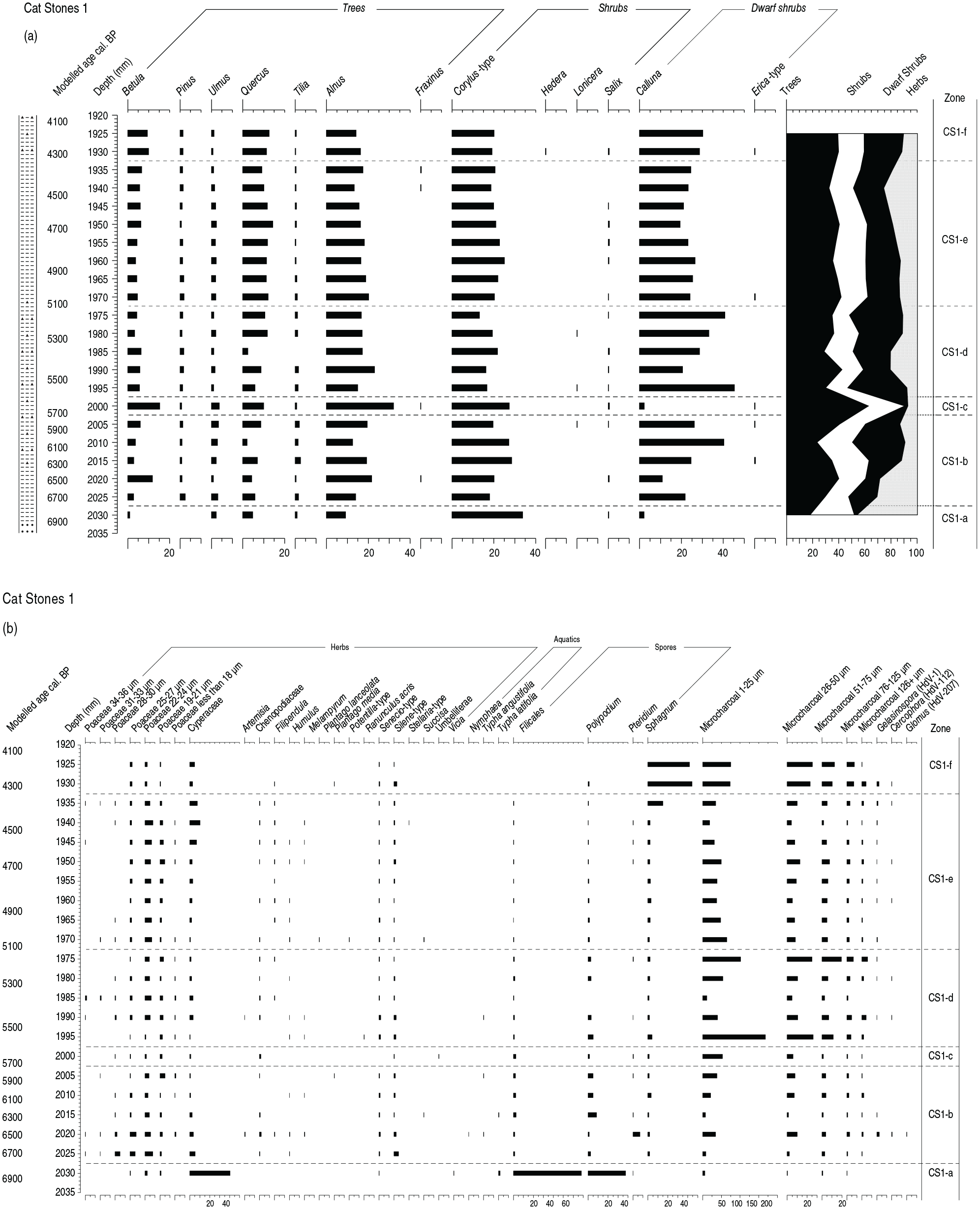
Pollen diagram from the base of Cat Stones 1, sampled at 5 mm intervals. Tree and shrub percentages are shown on (a), and herbs, spores, microcharcoal and selected NPPs on (b). Frequencies are shown as percentages of a total land pollen sum which includes trees, shrubs and herbs, but excludes spores and NPPs. Taxa represented in the various Poaceae size classes in this and other diagrams are listed in the laboratory methods section. A modelled calibrated ages BP scale is shown. Details of AMS date calibrations are shown on Table 2. Lithology symbols are: dots (sand), horizontal dashes (amorphous peat) and black triangles (small charcoal pieces). See Table 1.
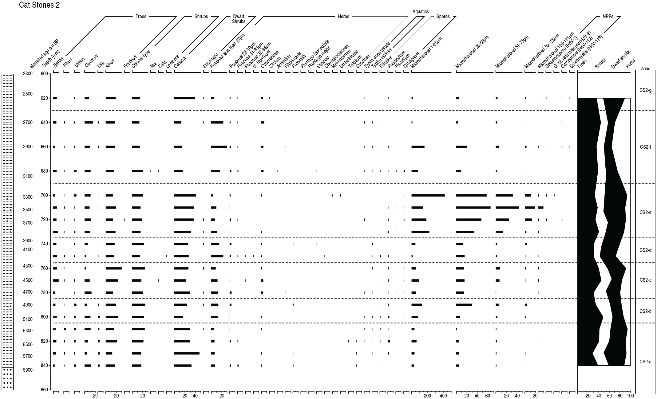
Pollen, spores, microcharcoal and selected NPPs diagram from the base of Cat Stones 2, sampled at 5 mm intervals. Frequencies are shown as percentages of a total land pollen (TLP) sum which includes trees, shrubs and herbs, but excludes spores and NPPs. A modelled calibrated ages BP scale is shown. Details of AMS date calibrations are shown on Table 2. Lithology symbols are: dots (sand), horizontal dashes (amorphous peat) and black triangles (small charcoal pieces). See Table 1.
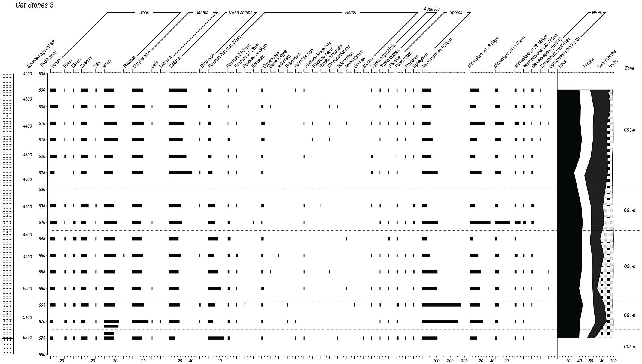
Pollen, spores, microcharcoal and selected NPPs diagram from the base of Cat Stones 3, sampled at 5 mm intervals. Frequencies are shown as percentages of a total land pollen sum which includes trees, shrubs and herbs, but excludes spores and NPPs. A modelled calibrated ages BP scale is shown. Details of AMS date calibrations are shown on Table 2. Lithology symbols are: dots (sand), horizontal dashes (amorphous peat) and black triangles (small charcoal pieces). See Table 1.
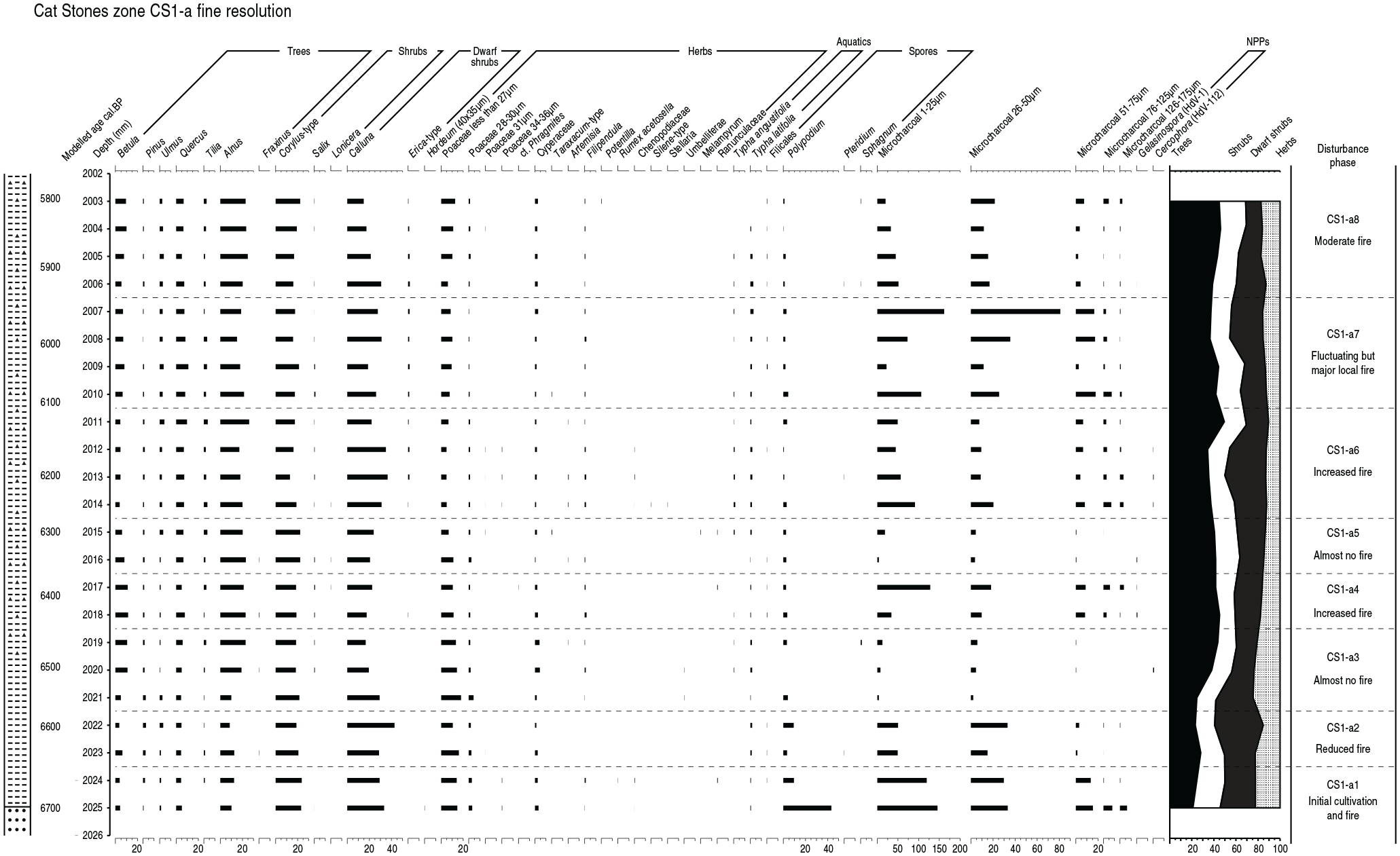
Fine resolution pollen, spores, microcharcoal and selected NPPs diagram between 2003 and 2025 mm from zone CS1 at Cat Stones 1, sampled at contiguous 1 mm intervals. Frequencies are shown as percentages of a total land pollen sum which includes trees, shrubs and herbs, but excludes spores and NPPs. A modelled calibrated ages BP scale is shown. Details of AMS date calibrations are shown on Table 2. The start of the Elm Decline occurs at 2000 mm (Figure 3), and is dated to 4940 ± 40 BP (modelled age of 5670 cal. BP). Lithology symbols are: dots (sand), horizontal dashes (amorphous peat) and black triangles (small charcoal pieces). See Table 1.
Zone and disturbance phase descriptions and modelled age ranges at Cat Stones (CS) profiles 1, 2 and 3.
Vegetation history
The combined Cat Stones pollen profiles provide a vegetation history extending from c. 6900 cal. BP at Cat Stones 1 to c. 2400 cal. BP at Cat Stones 2 (Figure 8). The pollen records overlap chronologically, so that the period from c. 5300–4200 cal. BP is represented at all three profiles, the periods from c. 4200–3900 and c. 5800–5300 cal. BP only in CS1 and 2, the period from c. 6900–5800 cal. BP only in CS1 and the period after c. 3900 only in CS2. The earliest pollen data, from the base of the CS1 profile, indicate paludification and the establishment of a sedge marsh at the site. The surrounding vegetation was dominantly Corylus and Alnus scrub, perhaps thicker in stream valleys. Hydroseral development saw the sedge marsh replaced by marsh grasses and fen herbs, with a few aquatic taxa, and local increase of Calluna. Alnus became more common than Corylus as local wetness increased. The frequencies of Ulmus, Quercus and Tilia are low and their pollen will have been transported from source areas further away on the plateau-edge slopes, as noted by Tallis and Switsur (1990). When pollen records from CS2 and CS3 become available, covering post-Elm Decline Neolithic and Bronze Age times, they are very similar to that recorded at CS1, with the same Calluna, Alnus and Corylus-type dominance. Quercus does increase slightly from pre-Elm Decline levels, but only to consistently between 10% and 15%, emphasising its non-local origin. Peaks in individual diagrams of some non-tree taxa, such as Poaceae and Sphagnum, do occur but will have been very local changes and not of wider significance, the Poaceae comprising mainly wetland grasses.
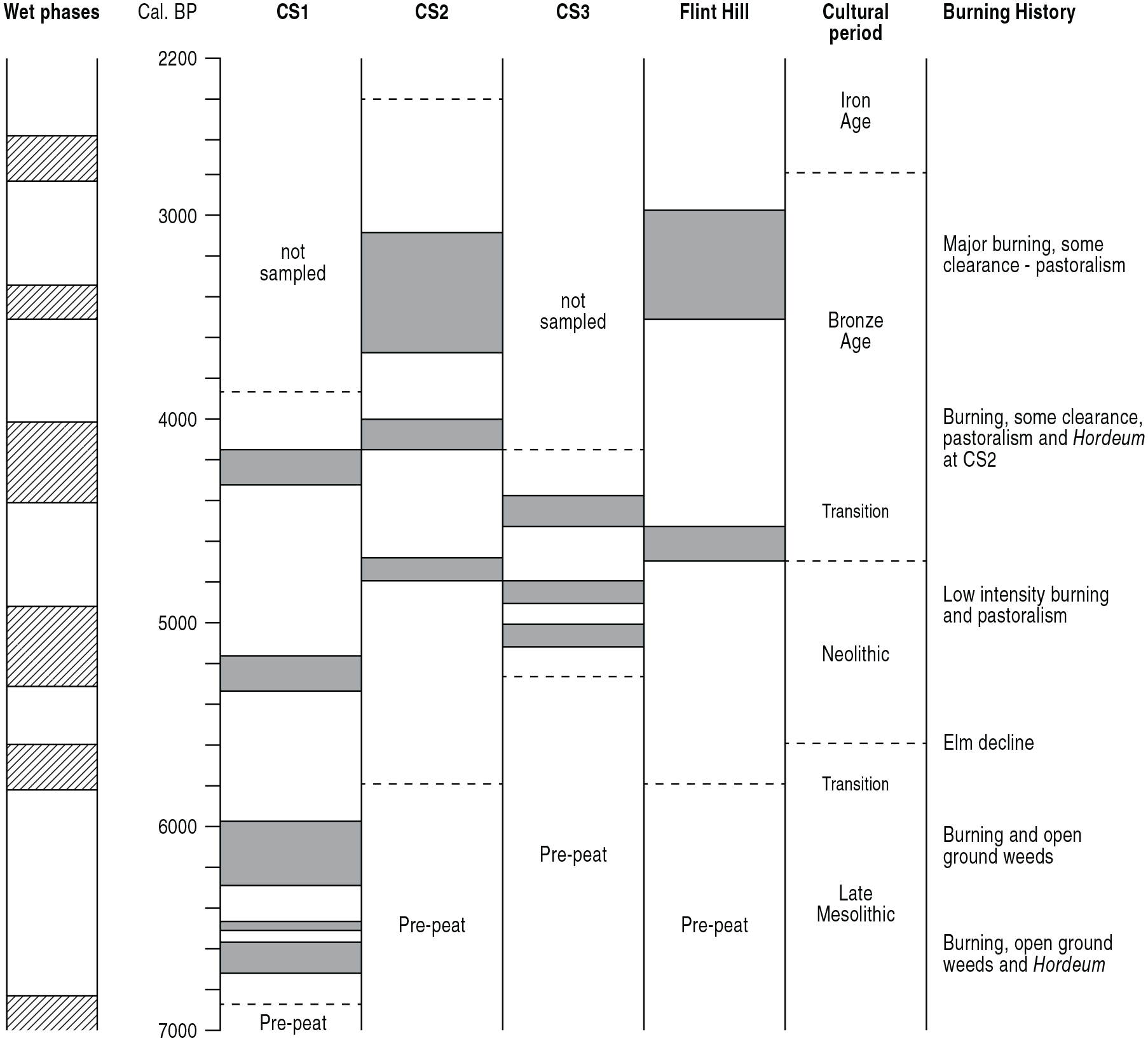
Correlation of burning history and disturbance phases at Rishworth Moor from the three sites in this paper (CS1–CS3) and the site of Bartley (1975) at Flint Hill. CS1 to CS3 use modelled ages, while the ages of disturbances at Flint Hill are interpolated from Bartley’s radiocarbon dated pollen diagram. Disturbance phases are shaded. Wetter and drier climate phases are also shown, following Hughes et al. (2000), with wetter phases shaded diagonally.
The stability of the vegetation within the pollen source areas of all three cores is notable, as the relative proportions of trees, shrubs, dwarf shrubs and herbs as percentages of total pollen are consistent, at about 40% for trees, 20% for shrubs, 25% for dwarf shrubs and 15% for herbs, with very little fluctuation throughout the combined Cat Stones vegetation history. After the Elm Decline, Ulmus percentages remain low in all three profiles. Although disturbances change their percentages slightly, Alnus, Corylus-type and Quercus remain consistent suggesting that little significant change in their distribution occurred. The only exception is just before the Elm Decline when a major expansion of deciduous woodland occurred at site CS1, with heather moorland greatly reduced, although it cannot be assumed that this change applied to the whole plateau area.
Vegetation disturbance
Disturbance is registered by increased microcharcoal levels and ruderal taxa, including Pteridium, Melampyrum, Artemisia, Chenopodiaceae, Senecio-type and Silene-type. The NPP Glomus occurs, usually indicating destabilisation and erosion of soil after vegetation disturbance (van Geel, 1986). In all cores the highest microcharcoal frequencies are in the smaller size classes, indicating that either burning was very light, or it occurred at some distance from the coring site, with the smaller size particles better transported. Although microcharcoal fluctuates throughout CS1, three disturbance phases of Late Mesolithic age occur, at c. 6672–6714, at c. 6500 and the third around c. 6088 cal. BP, shown on the high-resolution diagram, Figure 7. The oak-alder-hazel scrub was unaffected by it, although Fraxinus was encouraged. Fire perhaps took place within grassy Calluna heath, rejuvenating it (Davies, 2009; Whittaker and Gimingham, 1962) but not changing overall vegetation distributions. Disturbance occurs at the Elm Decline, but the highest percentages of tree pollen on the diagram occur just before it as woodland spread, perhaps onto the plateau from surrounding slopes, greatly reducing heather representation as disturbance pressure was relaxed. The period following the Elm Decline has renewed expansion of Calluna after burning, with phases of increased disturbance occurring in the Neolithic period at about 5177–5276 cal. BP at CS1, at c. 4900 cal. BP at CS2, and at c. 5005–5129 and c. 4800 cal. BP at CS3. Occurring for only a few centuries, these Neolithic phases do not correspond exactly, and are probably discrete local episodes of increased burning, although the c. 4800 cal. BP phase at CS2 and CS3 may well record a single larger scale disturbance. Macroscopic charcoal occurs at the level of the earlier phase at CS3, indicating local fire. Disturbances were not plateau-wide but localised events, with low-intensity fire always present somewhere in the catchment. Bartley (1975) noted a big increase in Calluna due to disturbance towards the end of the Neolithic at his Flint Hill site, but it is not registered at the CS profiles, showing that Neolithic disturbances were spatially restricted.
All three CS pollen profiles show a phase of disturbance that can be assigned to the early Bronze Age. It is possible that the c. 4800 cal. BP phase at CS2 and CS3 might represent the early Bronze Age Tilia decline (Turner, 1962), with Ulmus also falling, although this would be an early date for it. Although of similar scale, the Cat Stones later Bronze Age disturbances are not contemporaneous and do not represent a single large disturbance, with ranges of 4191–4290 cal. BP at CS1, a slight phase at c. 4172 cal. BP at CS2 and 4385–4571 cal. BP at CS3. Macroscopic charcoal occurs in the peat at this level at CS1, indicating local fire. An agricultural phase with Hordeum-type occurs at CS2 at c. 4200 cal. BP, followed by a prolonged period of burning. A more intensive and longer phase of disturbance occurs in the mid-Bronze Age from 3300–3800 cal. BP at CS2, and macroscopic charcoal occurs at this level, indicating local fire. The CS1 and CS3 profiles do not extend this late, so the extent of this disturbance is unknown and a single large disturbance across Rishworth Moor cannot be assumed. Bartley (1975) did record disturbance of around this date at Flint Hill, so perhaps this phase was of greater extent than the earlier examples. In summary, although several phases of disturbance can be recognised in the Cat Stones pollen record, none are of great intensity or spatial extent, and are probably confined to within the pollen source area of individual cores rather than being plateau-wide. The disturbances are compared chronologically on Figure 8, correlated with phases of wetter and drier climate (Hughes et al., 2000).
Discussion
As suggested by Bartley (1975) the pre-peat dryland vegetation at Cat Stones was probably similar to that proposed for the Pennine summits in general (Tallis, 1964), open, patchy scrubby woodland with considerable Calluna heath and grassy areas. Few wood remains were noticed on Rishworth Moor by Bartley (1975) or in the present study, although they could be concealed below the peat blanket. The Cat Stones pollen data, however, do indicate that open grassy heathland occurred on the flat plateau within alder, birch, and hazel scrub which would have been denser along the drainage channels, and extensive (Brayshay, 1999) on the plateau edge and on the hillslope immediately below the plateau during Late Mesolithic, Mesolithic–Neolithic transition times, and later. To what extent this mix of plateau heathland and open woodland around its edges would have been the ‘natural’ vegetation, or whether a result of a long period of earlier Mesolithic activity (Jacobi et al., 1976; Simmons and Innes, 1985), remains uncertain. The presence of oak and other tree stumps at much higher altitudes in the Pennines than that of Rishworth Moor (Tallis and Switsur, 1983, 1990) suggests that there was no climatic or other reason why closed woodland would not have covered the central Pennines plateaux in the mid-Holocene (Birks, 1988), and so other factors causing depression of the tree line at this time need to be sought. Extensive burning during Late Mesolithic times may have prevented the colonisation of moorland summits by trees in other northern English uplands (Simmons and Innes, 1981, 1988), as well as in the Pennines (Tallis, 1975). The presence of microcharcoal throughout the peat at Cat Stones suggests that fire was responsible. Macroscopic charcoal in the peat, and the presence of Gelasinospora, indicates that some of the burning was near the coring sites (van Geel, 1978), although smaller charcoal pieces might have been wind-transported. That the oak, alder and hazel frequencies do not show very major changes indicates that the burning may have been mainly on the heath and scrub vegetation of the plateau summit, and the Calluna curve does appear to be the pollen type most responsive to fluctuations in microcharcoal abundance, indicating a direct relationship between burning and heather moor in the mid-Holocene on Rishworth Moor. This close relationship between burning and Calluna has been commonly noted elsewhere (Edwards et al., 1995; Odgaard, 1992). At times, as in zone CS2-c where Poaceae values increase and Calluna frequencies are depressed, burning of heather may have been too intense and promoted the expansion of grassland at the expense of heathland, although heather eventually recovered. The effects of such disturbance in causing rapid transition from heather to grass dominance in historic times have been observed in palaeoecological studies of South Pennine peats (Davies, 2016).
Human activity
The pollen profiles from Cat Stones provide data enabling reconstruction of vegetation history and human land use. Allied to the previous work of Bartley (1975) at Flint Hill, an understanding of human-vegetation relations on this central Pennines summit plateau is possible.
The pre-Elm Decline period
The pre-Elm Decline period will equate with the Late Mesolithic occupation of the area, given the near-basal radiocarbon date of 5884±37 BP at Cat Stones 1 and the modelled age of 6923 cal. BP for peat formation. The presence of Late Mesolithic flint sites close by, including terminal Mesolithic ‘rod’-dominated sites which have been dated well into the Mesolithic–Neolithic transition in this region (Chatterton, 2007; Griffiths, 2014a; Spikins, 2002), supports the probable Mesolithic agency for any activity before the Elm Decline, unless pure rod sites have an association with the earliest Neolithic. Only Cat Stones 1 records pre-Elm Decline vegetation history, but the fine-resolution diagram provides detailed evidence. The Flint Hill profile of Bartley (1975) preserves little pre-Elm Decline peat but records dominance of the woodland of the Rishworth Moor area by Quercus and Alnus, with substantial Ulmus frequencies of almost 10% of tree pollen, and little non-arboreal pollen, with grass and Corylus–type the only significant taxa. Other trees, mainly Tilia and Betula, were present nearby. This agrees with the regional picture of the higher hillslopes of the Pennines, with open oak-alder woodland with moderate levels of hazel understory or scrub and some open, grassy heath areas (Birks, 1988; Tallis, 1991; Tallis and Switsur, 1990). Although Bartley’s pre-Elm Decline record does not contain much Ericaceae pollen, the Cat Stones 1 profile has significant frequencies of Calluna except in the period immediately before the Elm Decline (zone CS1-c on Figure 4a). It is probable that the pre-Elm Decline wooded phase at Bartley’s Flint Hill core corresponds to this brief wooded phase in core CS1. Flint Hill is also near the edge of the plateau and close to a stream channel that would be more likely to have supported trees. The high percentages of woodland in both the Flint Hill core and immediately before the Elm Decline at CS-1, completely replacing Calluna, require explanation. Although this was a wetter phase (Tipping, 2010), climate fluctuation alone seems an unlikely cause of such a transformation. More probable is a temporary withdrawal of human impact from Rishworth Moor for about a century, perhaps a brief temporal hiatus between Mesolithic and Neolithic activities there. Although there was a chronological overlap between the cultures in the wider region, there may well have been a spatial mosaic of culture change with some areas abandoned before later reoccupation.
Differences between Flint Hill and CS-1 could be accounted for by differing pollen source areas, Cat Stones 1 being more central to the plateau, while Flint Hill is near the plateau edge. Pollen studies on contemporary heather vegetation (Bunting, 2003; Evans and Moore, 1985) have shown that modern Calluna pollen frequencies correlate closely to the actual very local land coverage by heather, so that fossil Calluna frequencies can be assumed to be an accurate representation of past local heather abundance and distribution. In the case of the Cat Stones sites this would equate to about 25% local ground cover, with the rest grass and nearby scrub. During this pre-Elm Decline period the vegetation was probably a fluctuating mix of open scrub with clearings, in which heather and grasses grew. The proportions of Calluna and grasses at Cat Stones are high for its relatively modest altitude, and resemble the records from much higher altitude sites of over 500 m at sites in the southern Pennines (Tallis and Switsur, 1990).
The natural mid-Holocene climax vegetation on the Pennine plateaux should have been forest of some type (Birks, 1988), so a mechanism whereby scrub and grassy heather moorland came to dominate Rishworth Moor at this time must be found. Periods of cooler and wetter climate in the mid-Holocene (Langdon et al., 2003; Stolze et al., 2012; Tipping, 2010) may have played a part, and Hughes et al. (2000) in northern England record a wet phase around 7000 cal. BP which might have inhibited tree growth and prompted paludification in the centuries before peat formation on Rishworth Moor. Many workers, however, have called attention to pollen and charcoal evidence of woodland disturbance, often involving fire, at many pre-Elm Decline peat sites in the Pennines and in other British uplands. As at Rishworth Moor, sometimes this burning of Mesolithic age took place within Calluna-dominated upland scrubby heath (Caseldine and Hatton, 1993; Simmons, 2001; Smith and Cloutman, 1988; Squires, 1978), where Mesolithic hunters maintained open areas that had been created by previous woodland burning, preventing recolonisation by trees and rejuvenating the grassy heathland for grazing purposes. The alder-hazel scrub present during peat formation at CS1 may itself have been the result of earlier burning on the plateau. Repeated burning of the same site occurred in the late Mesolithic (Simmons and Innes, 1981, 1988). The regional pollen data for the central Pennines include many phases of woodland opening when Late Mesolithic hunter-gatherers were clearly present, judging from their many microlithic flint sites, interpreted as hunting camps in these uplands where there were high populations of deer and other game animals. It has been suggested that Late Mesolithic hunters may well have been responsible for creating or maintaining many of these upland woodland openings (Jacobi et al., 1976; Simmons, 1996) and it is a model of Late Mesolithic land use that seems persuasive, perhaps as part of postulated hunter-gatherer subsistence and mobility strategies (Donahue and Lovis, 2006; Preston, 2013b).
The pollen and microcharcoal fluctuations in the Cat Stones 1 pollen diagrams, Figures 4 and 7, suggest that in the millennium before the Elm Decline there was limited and localised disturbance of the vegetation three times, with fire as the main agency. The age-depth model suggests pre-Elm Decline disturbance dated to about 6672–6714, around 6500 and 5962–6254 cal. BP. While these fires occurred (Figure 8) during a generally drier climatic phase (Hughes et al., 2000; Tipping, 2010), which may have been permissive, it is likely that Mesolithic people might have been deliberately responsible (Brown, 1997) for fire-disturbance such as this in the central Pennine uplands, presumably for economic purposes although social reasons should not be discounted (Davies et al., 2005). The possibility of accidental escape of fire from hunting camp hearths, which have been found on these high altitude plateaux (Spikins, 2002), must also be considered (Bennett et al., 1990). There is evidence that such disturbances were common and modified the mid-Holocene vegetation in this region, as well as elsewhere in the British uplands (e.g. Blackford et al., 2006; Innes and Simmons, 2000; Innes et al., 2010, 2013; Simmons, 1996; Simmons and Innes, 1985, 1987). In the Pennines, Late Mesolithic flints have been found in stratigraphic association with layers of charcoal and pollen evidence of woodland opening, as at Stump Cross (Walker, 1956) and Dunford Bridge (Radley et al., 1974), which strengthens the link between disturbance and hunters. Microscopic and larger charcoal remains have been recorded at several Pennine sites in association with pollen evidence of woodland recession, and Fountains Earth (Tinsley, 1975), Valley Bog (Chambers, 1978), Pawlaw Mire (Sturludottir and Turner, 1985), Malham Tarn Moss (Pigott and Pigott, 1963), Quick Moss (Rowell and Turner, 1985), Gate Gutter (Gear and Turner, 2001), Eshton Tarn (Bartley et al., 1990), Fleet Moss (Honeyman, 1985), Lanshaw on Rombalds Moor (Bannister (1985) and Great Close Pasture (Smith, 1986) are regional examples. Often at higher altitudes the charcoal occurs at the base of the peat and in the soil beneath, as at Mire Holes in the north Pennines (Squires, 1978), and Late Mesolithic burning of wet, acidic woodland might have led to water surpluses and organic accumulation within the created clearings (Moore, 1975; Simmons, 1996; Simmons and Innes, 1985, 1987) so that, instead of regeneration of tree cover, the spread of marsh, heath and blanket bog was initiated, a long-term process of landscape change that became important in the uplands from this time onwards (Garton, 2017; Tallis, 1991). This process might have occurred at CS1. The work of Tallis in the Pennines to the south of Rishworth Moor provides examples at Lady Clough Moor (Tallis, 1975) and at Robinson’s Moss and Alport Moor (Tallis and Switsur, 1990). Closest to Rishworth Moor, the high-resolution work of Ryan and Blackford (2010) at Black Heath and Williams (1985) at Soyland Moor record significant woodland opening in what, given their respective radiocarbon dates of 5777 ± 37 BP and 5820 ± 95 BP, seem to be close temporal correlatives of the earliest Cat Stones disturbance phase at 5884 ± 37 BP. Also, a disturbance phase at nearby Lanshaw (Bannister, 1985) is dated to 5840 ± 80 BP, and Brown (1982) recorded an expansion of heath vegetation at a rod site at Rocher Moss dated to 5830 ± 100 BP. There were several fire disturbances of Late Mesolithic age in the central Pennines area around c. 5800 14C BP (c. 6600 cal. BP), although their similar dating is probably coincidental (Baillie, 1991). Climate was dry at this time in northern England (Hughes et al., 2000), perhaps increasing the natural incidence of fires. Notably, the disturbances at Black Heath, Soyland Moor and Cat Stones 1 contain large cereal-type grass grains, the Cat Stones example being Hordeum-type. Wiltshire and Edwards (1993) also recorded cereal-type pollen at nearby Lismore Fields, interpolated to around 5800 14C BP. It is speculative to interpret this grain at Cat Stones as indicating cereal cultivation (Griffiths, 2018; O’Connell, 1987), and we only record its presence. More research is needed on this topic.
The Elm Decline and the Neolithic
Bartley (1975) recorded very little indication of human activity or other disturbance in the Neolithic part of his Flint Hill core, with only a single Plantago lanceolata grain occurring immediately after the fall of elm. The Elm Decline itself, at around 5100 14C BP (c. 5800 cal. BP., Parker et al., 2002), is considered to lie within the early Neolithic period, and often pollen evidence of woodland opening and even cultivation coincides with it (Innes, 2002). Bartley found almost no such evidence and his fall in elm frequencies itself is not clear. Its date of 5490 ± 140 BP is very early and it might not be the true Elm Decline, as Tallis and Switsur (1990) suspected, which is probably higher in Bartley’s core. The date for the start of the Elm Decline at Cat Stones 1, at 4940 ± 40 BP, is much later than that at Flint Hill but is much closer to the usual date for the feature in the Pennine uplands, as at 4855 ± 50 BP (5710–5470 cal. BP) at Alport Moor and 4875 ± 60 BP (5740–5470 cal. BP) at Robinson’s Moss (Tallis and Switsur, 1990), at 4990 ± 140 (6008–5449 cal. BP) at Totley Moss (Hicks, 1971), at 4740 ± 70 (5593–5319 cal. BP) at Black Brook, Anglezarke Moor (Bain, 1991; Walker et al., 1987) and at 4865 ± 50 (5716–5476 cal. BP) at Soyland Moor (Williams, 1985), not far from Rishworth Moor. Although the present study employs a much finer sampling interval than Bartley did, the Elm Decline at Cat Stones 1 also has little evidence of Neolithic activity or interference with the local vegetation, with only a few grains of Plantago lanceolata and Chenopodiaceae present in the levels just above the elm pollen fall. This suggests that Bartley was correct in describing Neolithic impacts as slight. Microscopic charcoal frequencies of all size classes rise at the Cat Stones 1 Elm Decline, but the smallest size class most distinctly, and this may best be interpreted as transport from a distance (Blackford, 2000), perhaps from the higher slopes on the edge of the plateau. That the increase in woodland pollen at the expense of Calluna heath that occurs just before the Elm Decline (zone CS1-c and at Flint Hill) is reversed as Calluna expands again just after it, suggests some human impact on the plateau and at its margins associated with the Elm Decline event.
For the Elm Decline and for the Neolithic period as a whole, this record of low levels of impact on Rishworth Moor seems typical of the higher Pennines. The three Cat Stones profiles all cover the Neolithic and so allow a spatial investigation of environmental history, but there is little spatial variation recorded. The summary curves on the pollen diagrams show that tree and tall shrub frequencies at all three profiles are consistently around 60% of total pollen throughout the Neolithic levels, with the majority of the remaining pollen contributed by Calluna, with some wetland herbs like grass and sedge. All of the central Pennine Neolithic pollen assemblages between c. 5000 (c.5750 cal. BP) and c. 4000 14C BP (c.4450 cal. BP) (Hicks, 1971; Tallis and McGuire, 1972; Tinsley, 1975) are similar to Rishworth Moor in this respect. The high altitude pollen records closest to Rishworth Moor, at Soyland Moor (Williams, 1985) and Black Heath (Ryan and Blackford, 2010) do not extend far into Neolithic age peat. Only in the higher altitude limestone areas with better soils, as above Wensleydale (Honeyman, 1985) or in Craven (Bartley et al., 1990; Smith, 1986) is there evidence of significant forest clearance in the Neolithic. It is likely that Neolithic farming in the Pennines followed a ‘forest farming’ strategy rather than a more intensive one with ‘landnam’ style forest clearance (Edwards, 1993). A lower-scale ‘within woodland’ type of farming would be less visible in the pollen record and would account for the ephemeral signature of Neolithic farmers in this upland. There is a Neolithic-age episode of burning at all three Cat Stones profiles, however, so some Neolithic activity did occur on and around the Rishworth plateau. The identification of Cercophora and Sporormiella in CS3-e, for example, suggests the presence of animals, perhaps indicating low intensity stock herding. Similarly, Garton (2017) recorded charcoal layers of Neolithic age at altitude above Tintwistle 20 km south of Rishworth Moor, and it is clear that some fire-disturbance of the upland vegetation did take place in the millennium following the Elm Decline in parts of the central and southern Pennines.
The Bronze Age
The consensus of previous palaeoecological research in the central Pennines, and in all of the uplands of northern England, is that the early to mid-Bronze Age was the period when the first substantial clearances of woodland took place, causing long-lasting changes in upland vegetation communities (Barnes, 1982; Birks, 1988; Tallis and McGuire, 1972). This agrees with the Pennine archaeological record (Figure 1b), as Bronze Age sites are common (Barnes, 1982; Burgess, 1995; Manby, 1986; Manby et al., 2003) and occur on Rishworth Moor and its environs (Figure 1c), mainly as stray finds. They prove presence if not settlement. At CS2 the phase of disturbance which includes Hordeum-type pollen and ruderal weeds at about 4200 cal. BP probably relates to the early Bronze Age as it is contemporary with the Bronze Age archaeological site of Lindley Moor only a few kilometres to the east (Manby et al., 2003). As frequencies for Alnus, Quercus and Corylus-type decline, this disturbance probably took place within the scrub and woodland around the plateau edge although there were areas of alder and hazel scrub on the plateau. As microcharcoal increases only moderately, this might be an agricultural episode that did not involve major burning. The new Cat Stones data confirm the evidence presented by Bartley (1975) from his site at Flint Hill that some woodland opening, with oak being replaced by heather, took place on Rishworth Moor in the early Bronze Age, although it was not very intensive. The presence of cereal-type pollen, with the possible arable weed Chenopodiaceae, suggests a mixed cultivation and pastoral land use, although of limited intensity. As cereal-type pollen grains are not well dispersed (Hall et al., 1993; Vuorela, 1973), the activity was probably not far from the site, as is supported by the presence of small macroscopic charcoal.
The rises in microcharcoal and disturbance taxa around 3875 ± 30 BP (4416–4164 cal. BP) at Cat Stones 1 and after 3660 ± 35 BP (between 3900 and 3300 cal. BP) at Cat Stones 2 suggest major burning. This might have included opening of woodland, although the tree and shrub curves are little affected. Cereal-type pollen is absent during this phase at CS2 and most burning was within the plateau’s grassy heather moorland, which was rejuvenated. This might have been its purpose, to improve grazing. The already open nature of the Rishworth Moor vegetation meant that renewed burning, occurring within open communities, had little effect on arboreal/non-arboreal ratios. The Cat Stones modelled dates give a more accurate age context for that phase of activity and are well within the age range for previously recorded Bronze Age agricultural impacts in the Pennines. The Flint Hill and Cat Stones 2 Bronze Age disturbances are both near the western edge of the Rishworth Moor plateau, so the activity might have been concentrated in that area. The pollen records at CS1 and CS3, in the central and eastern areas, do not extend to the Bronze Age however, so it may be that Bronze Age disturbance affected the whole of the plateau. The introduction of the Bronze Age at Rishworth Moor can be characterised as increased impacts on the vegetation and the introduction of cereal cultivation as a small part of a mixed, but mainly pastoral, economy. As noted by Bartley (1975), these Bronze Age impacts were of low intensity and the very low values for dung fungi spores Cercophora and Sporormiella, as in CS2-f, suggest low concentrations of animals.
The Cat Stones Bronze Age disturbance phases join a large number of regional examples where the spread of open grassland, heath and bog vegetation at the expense of light woodland (Birks, 1988) took place after Bronze Age clearance phases. The first significant woodland clearances took place well after 4000 14C BP (c.4400 cal. BP) at the pollen sites of Leash Fen (Hicks, 1971, 1972), Deep Clough (Tallis and McGuire, 1972) and Fountains Earth (Tinsley, 1975, 1976), and therefore in the early and middle Bronze Age. At Leash Fen the clearances are dated to between 3740 ± 100 (4412–3859 cal. BP) and 3450 ± 110 BP (4057–3446 cal. BP). At Skell Moor Tinsley noted major clearance at 3880 ± 100 BP (4568–3984 cal. BP). At Deep Clough the clearance is dated to 3540 ± 120 BP (4151–3485 cal. BP). Similar evidence occurs throughout the central Pennines (Tallis and Switsur, 1973). To the north, Honeyman (1985) recorded major woodland clearance in Wensleydale at 3850 ± 50 (4416–4099 cal. BP) and 3930 ± 50 BP (4520–4184 cal. BP), while the first major clearance event occurred at Eshton Tarn in Craven (Bartley et al., 1990) at 3600 ± 100 BP (4224–3638 cal. BP). At lower altitude than Rishworth Moor, Eshton Tarn is on the flanks of the Pennines and its significant levels of cereal-type pollen indicate the different distribution of early Bronze Age settlement and agriculture, with more established and extensive arable cultivation at lower altitudes and much lower scale cultivation on the Pennine high plateaux. Cereal-type pollen occurs at most higher altitude sites in this period, and so a mixed economy with some cultivation was carried out even at high altitudes, which supports the Hordeum records at Cat Stones. While a warmer, drier climate in the Bronze Age (Burgess, 1985; Tipping, 2002) will have encouraged the spread of agriculture up the Pennine hillslopes, animal husbandry and pastoralism was the main agricultural pursuit on Rishworth Moor at this time, as at most summit plateau sites in the central Pennines and in other English uplands (Bradley, 1972; Fleming, 1971; Manby et al., 2003).
Conclusion
The research at Cat Stones has demonstrated that fine-temporal and fine-spatial analyses greatly enhance the detail and the intelligibility of palynological data. Taking more than one core in even a small area will provide a fuller understanding of vegetation change than a single core. Using a fine sampling interval gives a much clearer picture of short-term environmental change, revealing evidence that might well be missed at coarser sampling. Methodologically, separation of the microcharcoal data into size classes has enhanced understanding of the particles’ taphonomy and of the spatial location of the burning relative to the pollen sampling sites, and its use in palaeofire studies is recommended. The division of Poaceae grains into size classes has also been useful, as it showed the relative proportions of various wetland wild grasses in the assemblages, with the low percentages of very large grass grains other than those identified as of cereal type reducing scope for confusion at that end of the size scale. The addition of NPP counts to the pollen data has proved useful and, although in low percentages, they have enhanced the interpretation of local environments.
Cat Stones supports previous study in showing that human impacts in this upland area were low scale and mainly pastoral, although the finding of Hordeum-type pollen shows that limited cultivation probably extended to high altitude during the Neolithic and Bronze Age, unless these pollen grains were carried to this altitude from elsewhere, which seems unlikely. Pastoralism (Fleming, 1971) was the main land-use method, even though grazing indicators are few. Perhaps livestock were released onto the plateau and dispersed rather than herded. There is no clear relationship between disturbances and climate fluctuation, so they are most likely to record human activities. Disturbance before the Elm Decline, and the presence of Hordeum-type pollen, adds Cat Stones to a local group of sites, including Soyland Moor (Williams, 1985), Black Heath (Ryan and Blackford, 2009) and Lismore Fields (Wiltshire and Edwards, 1993), where cereal-type pollen might record a phase of cultivation very early in the Pennine Mesolithic-Neolithic Transition. The Cat Stones record of these Hordeum-type grains adjacent to rod flint sites, as recorded in the North York Moors (Albert and Innes, 2015), suggests that the cultural affinities of rod flint sites during the transition require further investigation. If these grains were not cereals, but wild grasses, the fire disturbance still places Cat Stones with the larger group of pre-Elm Decline disturbances attributable to Late Mesolithic activity (e.g. Simmons, 1996; Simmons and Innes, 1987). Rishworth Moor requires more high-resolution palaeoecological scrutiny of the Mesolithic-Neolithic Transition.
Supplemental Material
sj-docx-6-10.1177_0959683620972768 – Supplemental material for Multi-profile fine-resolution palynology of Late Mesolithic to Bronze Age peat at Cat Stones, Rishworth Moor, Central Pennines, UK
Supplemental material, sj-docx-6-10.1177_0959683620972768 for Multi-profile fine-resolution palynology of Late Mesolithic to Bronze Age peat at Cat Stones, Rishworth Moor, Central Pennines, UK by Bruce M Albert, James B Innes and Jeff J Blackford in The Holocene
Supplemental Material
sj-eps-2-hol-10.1177_0959683620972768 – Supplemental material for Multi-profile fine-resolution palynology of Late Mesolithic to Bronze Age peat at Cat Stones, Rishworth Moor, Central Pennines, UK
Supplemental material, sj-eps-2-hol-10.1177_0959683620972768 for Multi-profile fine-resolution palynology of Late Mesolithic to Bronze Age peat at Cat Stones, Rishworth Moor, Central Pennines, UK by Bruce M Albert, James B Innes and Jeff J Blackford in The Holocene
Supplemental Material
sj-eps-3-hol-10.1177_0959683620972768 – Supplemental material for Multi-profile fine-resolution palynology of Late Mesolithic to Bronze Age peat at Cat Stones, Rishworth Moor, Central Pennines, UK
Supplemental material, sj-eps-3-hol-10.1177_0959683620972768 for Multi-profile fine-resolution palynology of Late Mesolithic to Bronze Age peat at Cat Stones, Rishworth Moor, Central Pennines, UK by Bruce M Albert, James B Innes and Jeff J Blackford in The Holocene
Supplemental Material
sj-eps-4-hol-10.1177_0959683620972768 – Supplemental material for Multi-profile fine-resolution palynology of Late Mesolithic to Bronze Age peat at Cat Stones, Rishworth Moor, Central Pennines, UK
Supplemental material, sj-eps-4-hol-10.1177_0959683620972768 for Multi-profile fine-resolution palynology of Late Mesolithic to Bronze Age peat at Cat Stones, Rishworth Moor, Central Pennines, UK by Bruce M Albert, James B Innes and Jeff J Blackford in The Holocene
Supplemental Material
sj-eps-5-hol-10.1177_0959683620972768 – Supplemental material for Multi-profile fine-resolution palynology of Late Mesolithic to Bronze Age peat at Cat Stones, Rishworth Moor, Central Pennines, UK
Supplemental material, sj-eps-5-hol-10.1177_0959683620972768 for Multi-profile fine-resolution palynology of Late Mesolithic to Bronze Age peat at Cat Stones, Rishworth Moor, Central Pennines, UK by Bruce M Albert, James B Innes and Jeff J Blackford in The Holocene
Supplemental Material
sj-xlsx-1-hol-10.1177_0959683620972768 – Supplemental material for Multi-profile fine-resolution palynology of Late Mesolithic to Bronze Age peat at Cat Stones, Rishworth Moor, Central Pennines, UK
Supplemental material, sj-xlsx-1-hol-10.1177_0959683620972768 for Multi-profile fine-resolution palynology of Late Mesolithic to Bronze Age peat at Cat Stones, Rishworth Moor, Central Pennines, UK by Bruce M Albert, James B Innes and Jeff J Blackford in The Holocene
Footnotes
Acknowledgements
We are very grateful to Chris Orton of the Design and Imaging Unit, Geography Department, Durham University for the figures and to the landowner for access to the site. Radiocarbon dating was carried out at Poznan Radiocarbon Laboratory, Poland, at SUERC Radiocarbon Dating Laboratory, Glasgow, UK and at Beta Analytic, Florida, USA. We are grateful to the Principal Investigator, Professor Peter Rowley-Conwy, for managing the project.
Funding
The author(s) disclosed receipt of the following financial support for the research, authorship, and/or publication of this article: This work was supported by the Leverhulme Trust under project F/00128/BD.
Supplemental material
Supplemental material for this article is available online.
References
Supplementary Material
Please find the following supplemental material available below.
For Open Access articles published under a Creative Commons License, all supplemental material carries the same license as the article it is associated with.
For non-Open Access articles published, all supplemental material carries a non-exclusive license, and permission requests for re-use of supplemental material or any part of supplemental material shall be sent directly to the copyright owner as specified in the copyright notice associated with the article.