



Abstract
This paper presents new multi-proxy records of the Holocene environmental and climatic changes in the Western Caucasus revealed from a continuous sediment sequence from mountainous Lake Khuko (Caucasus State Natural Biospheric Reserve, 1744 m a.s.l.). Palaeoecological analyses of a sediment core for grain size, magnetic susceptibility, loss on ignition, and pollen allowed us to determine five principal climatic phases with several subphases since 10.5 ka BP. The age model is based on seven accelerator mass spectrometry 14C dates, supplemented by 210Pb data for the uppermost part of the sediment core. Warm periods (10.5–6.7, 6.7–5.5, 3.5–2.4, 0.8–0.5 ka BP) were characterized by high biological productivity in the lake as indicated by high organic matter content and expansion of forests, typical of modern low and middle mountain zones, as indicated by the increase in abundance of Quercus, Ulmus, Corylus, and Tilia in the pollen assemblages. Cold periods (5.5–3.5, 2.4–0.8, and 0.5 ka BP–present) are marked by a consistent decrease in organic matter content in lake deposits and possibly higher intensity of the catchment erosion. The changes in pollen assemblages (for instance peaks of Abies, Picea, and Pinus) suggested a potential elevational decline in the boundaries of vegetation belts and expansion of high-altitude woodlands. Abrupt changes in the lake ecosystem were identified between 4.2 and 3.5 ka cal BP marked by a short-term variation in sediment regime shown by variation in organic matter content, magnetic susceptibility values, and sediment grain size. This was probably caused by climatic fluctuations in the Western Caucasus region as a result of complex shifts in the ocean-atmosphere system during the 4.2 ka event. Overall, the first Holocene multi-proxy continuous lake sediment record provides new insights into the climate history in the Western Caucasus.
Introduction
Mountainous regions are currently undergoing rapid environmental change (Pepin et al., 2015) that is most clearly manifested in accelerated loss of glaciers (Hock et al., 2019; Solomina et al., 2008). These regions will be significantly influenced by rapid climatic change projected for the 21st century (Gobiet et al., 2014; Hock et al., 2019). The Holocene climate in mountainous regions and elsewhere was characterized by high temporal and spatial variability (Christiansen and Ljungqvist, 2017; Maslin et al., 2019; PAGES 2k Consortium, 2017), therefore paleoclimatic records may be useful in unraveling the regional imprints of ongoing climatic change. In addition, the proxy records retrieved from mountainous lakes enable anthropogenic versus natural components of change to be assessed (Fischer et al., 2018; Moser et al., 2019). The Caucasus holds a great potential for paleoenvironmental studies.
Located at the convergence of Europe and Asia between the Black and Caspian Seas, the Caucasus is the world’s eighth highest mountain range with Mt. Elbrus (5642 m) situated in its northern part. This region is characterized by an exceptionally high diversity of landscapes, a wide range of hydroclimatic conditions, and high biodiversity, which places it in one of Earth’s 25 biodiversity hotspots (Myers, 2000). The region experienced a dramatic decline in glacier cover over the last decades (Shahgedanova et al., 2014; Solomina et al., 2015, 2016a, 2016b; Tielidze et al., 2020; Toropov et al., 2019). The high-altitude zone of the Caucasus is largely free of direct human impact and therefore it is well suited to study present and past natural environmental changes.
Long continuous paleoenvironmental records from lacustrine sediments are scarce in the Caucasus, however, there are thousands of mountainous lakes in the region. While there are some important publications available for the broad region (e.g. Connor and Kvavadze, 2009; Joannin et al., 2014; Leroyer et al., 2016; Ryabogina et al., 2019), the Western Caucasus still largely remains unstudied. A recent review of publications devoted to the Caucasus presented in Solomina et al. (2016a) demonstrates that available paleoenvironmental data represent the general trend of climate variability or are focused on local phenomena, while the chronological boundaries of even the most prominent climatic shifts within the Holocene remain unclear for Western Caucasus (Bliedtner et al., 2018; Efremov, 1991; Kvavadze and Efremov, 1996; Margalitadze, 1995; Messager et al., 2013, 2017; Moiseenko et al., 2012; Ryabogina et al., 2019, 2020; Serebryaniy et al., 1984). Most previous paleoclimate data (e.g. Knyazev et al., 1992; Kvavadze and Efremov, 1996; Serebryaniy et al., 1984) are constrained by bulk conventional (not accelerator mass spectrometry, AMS) 14C dates and these dates are reported as uncalibrated years BP. Moreover, as a rule, sediment accumulation rate estimates are based on a single date determination and therefore the chronological resolution of these reconstructions is very poor. While the recent papers by Ryabogina et al. (2019, 2020) provide very detailed and comprehensive paleoenvironmental reconstruction, their study site is in the Dagestan Republic, where the climate significantly differs from the Western Caucasus.
The Russian Academy of Science’s Institute of Geography began studying mountain lakes in the Western Caucasus (Karachevo-Cherkessiya and Kabardino-Balkaria Republics of the Russian Federation) around 10 years ago when sediment cores were obtained from Lake Karakel and Lake Donguz-Orun (Chepurnaya, 2014; Solomina et al., 2013, 2014). While the sediment sequence from Lake Karakel comprises the entire Holocene it has a hiatus of ca. 2000 years in the middle Holocene. Annually laminated sediments in Lake Donguz-Orun near Terskol village, Kabardino-Balkaria cover <1000 years (Alexandrin et al., 2018). Despite the large amount of data previously obtained, large portions of the Holocene environmental history remained unknown.
This paper presents a new reconstruction of climate and vegetation for the Holocene in the Western Caucasus. The reconstructions were derived from analysis of grain size, magnetic susceptibility, loss on ignition, and pollen using a sediment core collected from Lake Khuko located in the K. G. Shaposhnikov Caucasus State Biospheric Reserve. The sediment sequences of this lake accumulated throughout the entire Holocene without any distinct hiatus. Current and additional future analyses of high-resolution multiproxy data from Lake Khuko will shed new light on Holocene climate and vegetation changes in this region and allow us to examine the role of climate in the lake paleoenvironment.
Study area
Lake Khuko (43°56′N, 39°48′E; Figure 1), presumably of tectonic origin (Efremov, 1991), is situated in the Western Caucasus on the border of the Republic of Adygea and the Krasnodar Territory. It is located at an altitude of 1744 m a.s.l. in the K. G. Shaposhnikov Caucasus State Natural Biospheriс Reserve protected area within the southern macro-slope of the Main Caucasus Range in its western part, 10 km northwest of Mt. Fisht (Efremov, 1991). The lake is ~260 m long and ~150 m wide, with an area of ~27,500 m2. No rivers flow in or out of the lake, except for one small creek draining the lake from the west side.
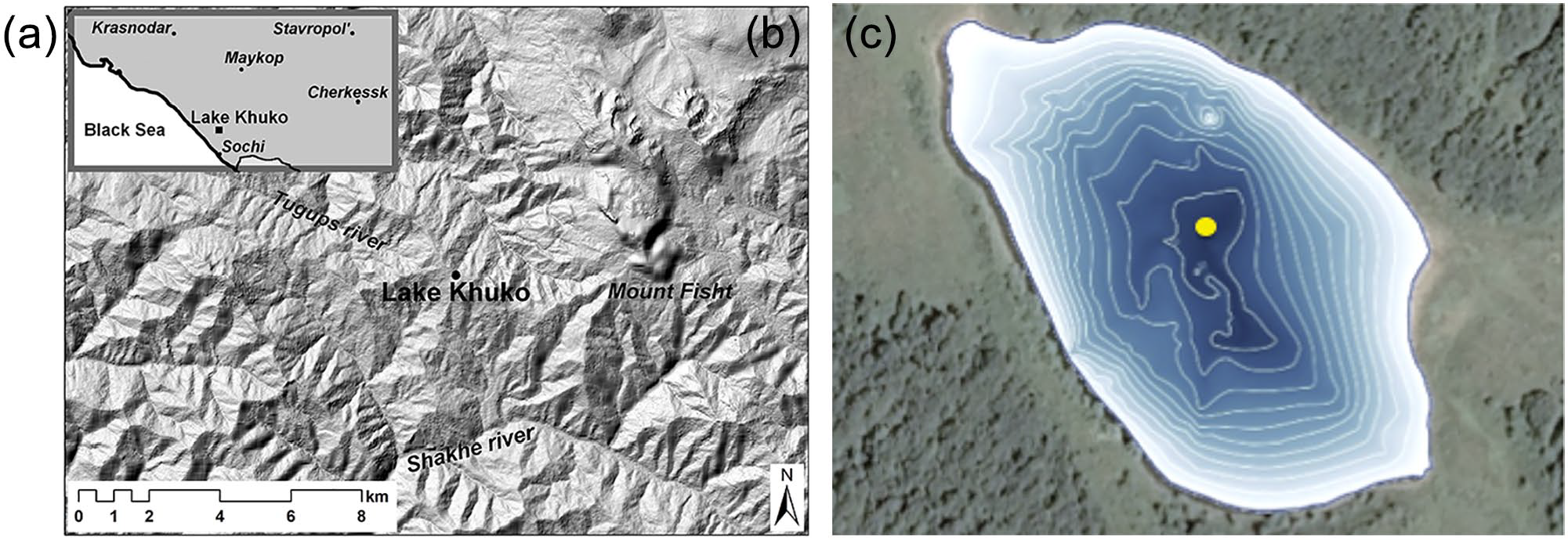
Geographical setting. (a) Southwestern Russia. (b) Lake Khuko location. (c) Lake Khuko.
The region is characterized by rugged topography with abundant screes and rocky outcrops. The part of the Main Caucasus Range in the vicinity of Lake Khuko is composed of Precambrian and lower Paleozoic gneiss, crystalline shales, and granites of Chegem formation (Efremov, 1991). Glacier moraines are typical in the Quaternary deposits. The study area is located at the boundary between temperate and subtropical climatic belts. Dominant south-westerly winds make the climate relatively warm and humid, with high precipitation at the altitude of Lake Khuko. Currently the mean annual temperature is around 5°C, the mean July and January temperatures are 15°C and −4°C, respectively, and annual precipitation reaches 2000 mm. The lake remains snow and ice-covered for 9–10 months of the year.
The vegetation of the study area is influenced by topography and altitudinal zonality (Ermolaeva, 2007; Golgofskaya, 1967). The low mountain belt between 600 and 900 m a.s.l. is composed primarily of beech (Fagus orientalis) and oak (Quercus robur, Q. petraea, Q. iberica) forests with an admixture of Carpinus betulus, Ulmus glabra, Acer laetum, A. pseudoplatanus, A. platanoides, and Fraxinus excelsior (Golgofskaya, 1967). Sambucus nigra, Corylus avellana, Rhododendron ponticum, Cornus alba, C. mas, and Euonymus europaeus are common in a shrub layer. South slopes below 800 m a.s.l. are covered by woodlands of Castanea sativa. Alnus glutinosa and A. incana grow on wet soil in river valleys. The middle altitude mountain forests (900–1600 m a.s.l.) are formed mainly by Fagus orientalis and Abies nordmanniana with participation of Carpinus betulus, Tilia caucasica, and several species of Quercus. Pyrus and Malus are abundant in former settlements. Abies nordmanniana and Acer trautvetteri are characteristic as an admixture in Fagus forests in the high-altitude forest belt (1600–2000 (2300) m a.s.l.) and its uppermost part is often formed by Pinus sylvestris, P. hamata, Abies nordmanniana, and Picea orientalis. Prunus laurocerasus, Rhododendron caucasicum, and Vaccinium myrtillis are abundant in brushwood and crooked forests (Komarova, 2017). Sub-alpine mountain meadows and alpine vegetation occupy areas above the upper timberline (Ermolaeva, 2007). Lake Khuko is located in the high-altitude forest zone and surrounded by beech forest.
Materials and methods
Bathymetry and coring
Fieldwork and coring were carried out in 2016. Before coring, a detailed bathymetric survey with a portable instrument was conducted, which revealed the deepest part of the lake with depths around 10 m (Figure 1). Coring was performed at this part of the lake using a Nesje-type corer (Nesje, 1992). The obtained core (Figure 2) was 196 cm long. The sampling interval for all types of analysis was 1 cm except pollen that was performed at 10-cm increments.
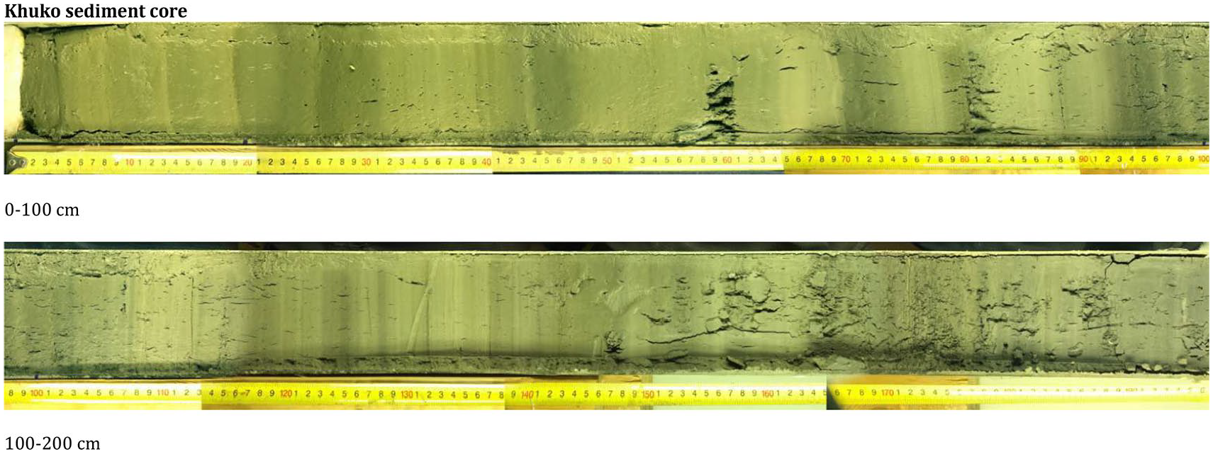
Lake Khuko sediment core.
Gamma spectrometry, AMS dating, the age-depth model
The uppermost part of the sediment core from Lake Khuko was radiometrically dated using 210Pb and 137Cs (see the details in Kuzmenkova et al., 2020). Dating using 210Pb was validated by independent measurements of 137Cs activity allowing identification of the layer corresponding to 137Cs fallout after the Chernobyl accident in 1986. Ten 0.5 cm sections of the core (in the depth interval 0–5 cm) were analyzed for total 210Pb activity and the corresponding data points for the inferred ages that were previously published in Kuzmenkova et al. (2020) appear in Figure 3.

The age model.
Seven radiocarbon dates were obtained for the sediment core from the lake (Table 1). Sample preparation for subsequent 14C analysis using accelerator mass spectrometry (AMS) for age determination of the sediment was performed at the Common Use Center “Radiocarbon Dating and Electron Microscopy Laboratory” of the Institute of Geography RAS. A AGE-3 graphitization system (Ionplus, Switzerland) was employed. Measurements to determine the radiocarbon age were performed using standard protocol through the cooperation agreement with the University of Georgia (USA). The age-depth model for Lake Khuko (Figure 3) is based on a combination of radiocarbon dating and 210Pb results published in Kuzmenkova et al. (2020). The model was created with the Bacon algorithm using Bayesian probability (Blaauw and Christen, 2011) and R statistical software (R Core Team, 2014). The IntCal13 calibration curve was used to determine the calendar age (Reimer et al., 2013). Throughout when the notion “ka BP” is used, calibrated age is implied.
Results of radiocarbon dating of the samples from Lake Khuko sediment core.
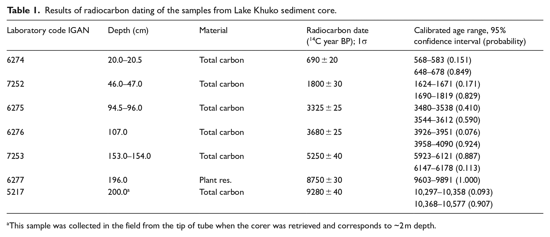
This sample was collected in the field from the tip of tube when the corer was retrieved and corresponds to ~2 m depth.
Magnetic susceptibility, loss-on-ignition, and grain size measurements
The magnetic susceptibility parameter (Dearing, 1999; Nowaczyk, 2001) is widely employed in paleoclimatological studies as magnetic properties of lacustrine sediments vary with the concentration and shape of the magnetic particles within the sediment (Bolshakov, 1996; Khramov et al., 1982), which in turn depend on the composition, the concentration of the magnetic fraction in the source rocks, and the size of the magnetic particles. The magnetic susceptibility parameter in the core from Lake Khuko was measured using ZH Instruments SM-30 handheld meter with a sensitivity of 1 × 10⁻⁷ (SI).
Percentage loss on ignition (LOI) is a widely used method to estimate the organic content (LOI at 550°C, hereafter LOI550°C) and the carbonate CO2 content (LOI950°C) of sediments (Heiri et al., 2001). Samples were heated at 105°C for 12 h, then at 550°C for 4 h, and finally at 950°C for 2 h. The results were calculated according to Heiri et al. (2001).
The grain size analysis was carried out by first sieving particle sizes greater than 1 mm and then assessing smaller particle sizes with laser diffractometry using a Malvern Mastersizer 3000 instrument. The precision of the laser diffractometry method, in general, has been discussed in Miller and Schaetzl (2012). Only the silicate portion of the sediment, as the most resistant to diagenesis, was analyzed. The process of sample preparation included treatments with a 20% hydrogen peroxide solution (to remove organic matter) and then with 10% hydrochloric acid solution (to remove carbonates), and finally with 4% sodium pyrophosphate solution (to disperse clay aggregates). Particle size distribution was calculated using the Fraunhofer approximation. The diatom silica was not specifically checked for.
Pollen analysis
Samples were prepared for pollen analysis following a gravity separation method developed by Grichuk and Zaklinskaya (1948) and subsequently improved at the Institute of Geography RAS. The sample preparation included: treatment with 10% pre-heated HCl solution to remove carbonate, heating for 10 min in 10% KOH to remove humic material, separation by heavy liquid (cadmium iodide) with a density of 2.2 g cm−3. The sample treatment was finalized by the acetolysis step to remove cellulosic material such as small debris and cell walls (Bennett and Willis, 2002). Lycopodium spores in tablets were added to each sample to determine the pollen concentration (Stockmarr, 1971). Pollen was identified using a Motic BA310 binocular microscope at 400 magnification following Reille (1992) and the reference collection in the Institute of Geography RAS. A minimum of 500 pollen grains per sample were counted. Calculation of pollen percentages was based on the terrestrial pollen sum that included arboreal pollen (AP) and non-arboreal pollen (NAP). The proportion of Alnus, aquatic plants, spores, and algae were calculated relative to this sum. Pollen diagram was plotted using the Tilia and TGView software (Grimm, 1990).
Results
Core chronology and accumulation rate
According to an age-model based on the radionuclides 210Pb and 137Cs the uppermost 6.5 cm of the sediment sequences was formed between 220 and 30 years ago with the accumulation rate of about 0.3 mm/year. There was an elevated content of 137Cs in the upper horizon (0–0.5 cm), that likely resulted from the Chernobyl accident. According to the position of the peak in the upper 0.5 cm, the maximum period of formation of this layer can be estimated at 30 years (year of sampling: 2016). Thus, the maximum accumulation rate for the uppermost layer is 0.0017 mm/year (see the details in Kuzmenkova et al., 2020).
Radiocarbon dating of the basal sample of the core showed that accumulation began in the early Holocene. Based on the age model (Figure 3), the mean accumulation rate in the period 10.5–7.0 ka BP was about 0.12 mm/year. For the period 7.0–6.0 ka BP the accumulation rate increased to 0.2 mm/year and remained quasi-stable at this level up to 2 ka BP. At ~1.5 ka BP the accumulation rate increased again and reached 0.3 mm/year.
Lithostratigraphic description and grain size analysis
Based on the lithostratigraphic description of the core, the sequence was divided into five sediment units (Table 2, Figure 4). The sediment core consisted of silt; the median grain size varied from 5.4 to 12.8 µm with most values in the range 6–8 µm. An increase of the share of fine sand was observed between 103 and 96 cm (3.8–3.6 ka BP) that was marked by a pronounced peak in the median grain size value up to 12.8 µm.
Lithostratigraphic description of the sediment sequence from Lake Khuko.
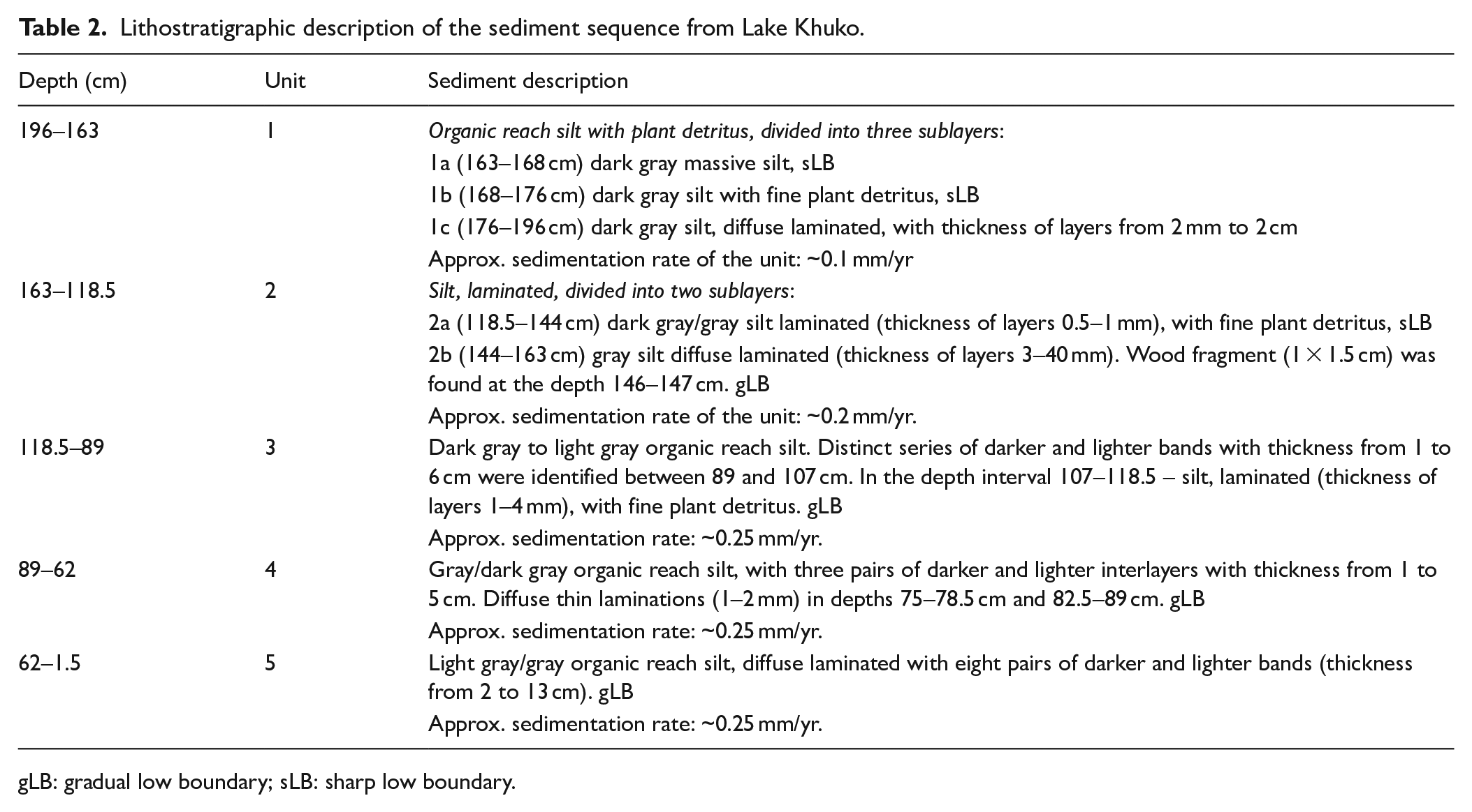
gLB: gradual low boundary; sLB: sharp low boundary.
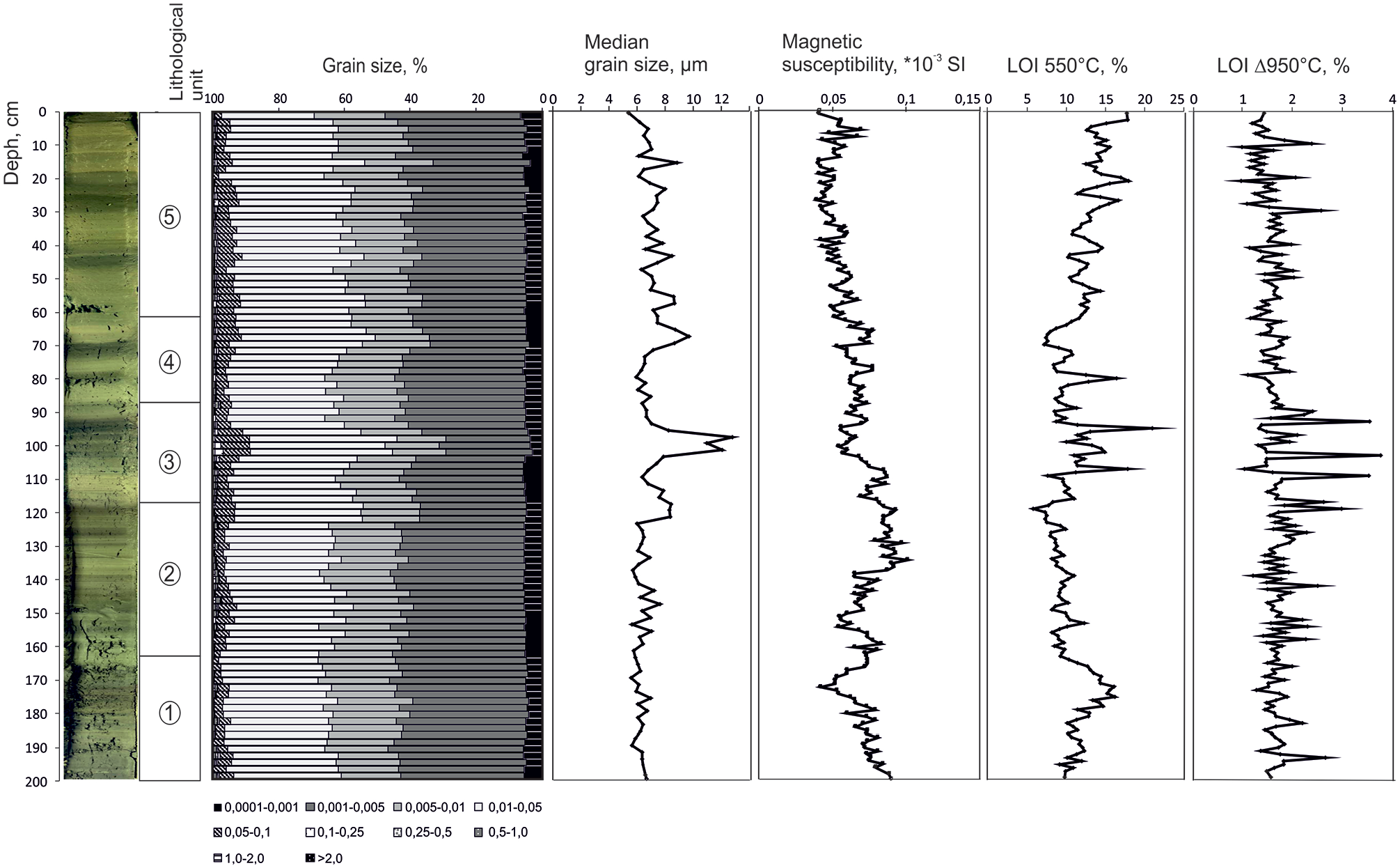
Measured parameters in the sediment core: grain size, magnetic susceptibility, LOI550°C LOI950°C.
The sediments showed alternating layers with light-colored and dark-colored, organic-rich bands, the thickness of the pairs of these layers varied from 5 to 15 cm (Figure 2). Thin horizontal laminations with the thickness of layers from 0.5 to 1 cm occurred in depths 75–78.5 cm, 82.5–89 cm, and 118.5–163 cm, bands with the thickness 1–4 mm were observed in depths 107–118.5 cm. The fine plant detritus was abundant in the lowermost part of the sediment sequences in depths 168–196 cm (10.5–7.1 ka BP). The lightest silt layers, apparently poor in organic matter content, were observed at depths around 110, 85, 77, and 67 cm, corresponding roughly to 4.1, 3.2, 2.9, and 2.5 ka BP (Figure 2).
Loss on ignition
The organic matter content of the sediments (LOI550°C) ranged between 6 and 21%. In the lower part of the core, LOI550°C was about 10%, then it increased to 16% at 170 cm, and subsequently declined to around 9% at 130 cm. Between 130 and 70 cm, the organic matter content varied from 9 to 15% except for pronounced peaks at 106 cm, 94 cm, 80 cm, and the highest value being 21% at 94.5 cm (~3.5 ka BP). Above 70 cm LOI550°C gradually increased toward the top of the core, where values reach about 16%. The carbonate content was low throughout whole sediment sequences. The minimum LOI950°C value was 0.98% at 20.5 cm, whereas the maximum value was 3.76% at 102.5 cm. Most of the values fell within the range of 1–2%, except for peaks that exceeded 2.5% at the depths 92 and 108 cm. It is important to note several peaks of LOI550°C and LOI950°C clustered in the interval ~110–90 cm and several peaks of LOI950°C in the upper part of the sequence (Figure 4).
Magnetic susceptibility
The values for the magnetic susceptibility ranged between 0.04 and 0.1 (volume magnetic susceptibility, dimensionless). Moving from the bottom of the core upwards the values initially decreased from ~0.08 to 0.04 at 172 cm, reached a maximum of 0.1 at 134 cm (~5.7 ka BP), and then decreased to 0.05. The minimum of magnetic susceptibility (0.042) occurred at about 172 cm. The values then rapidly increased and reached maximum (0.101) at ~134 cm. An interval when rather high values persisted was between 137 and 107 cm (~5.9 to ~4 ka).
Pollen and vegetation history
Pollen assemblages from the Lake Khuko sediment core were dominated by arboreal pollen (80–95%) which suggests forest vegetation in the area surrounding the lake throughout the Holocene. Changes in the ratio of the main pollen taxa in Lake Khuko diagram (Figure 5), allowed us to determine six local pollen assemblage zones (LPAZ; Table 3). Unfortunately, at present we cannot reliably calculate pollen concentration, because the Lycopodium marker was too low.

Pollen diagram of the sediment core from the lake Khuko (pollen sum: AP + NAP; Alnus excluded from the base sum; additional curves represent ×10 exaggeration of base curves).
Results of pollen analysis of the sediment core from Lake Khuko.
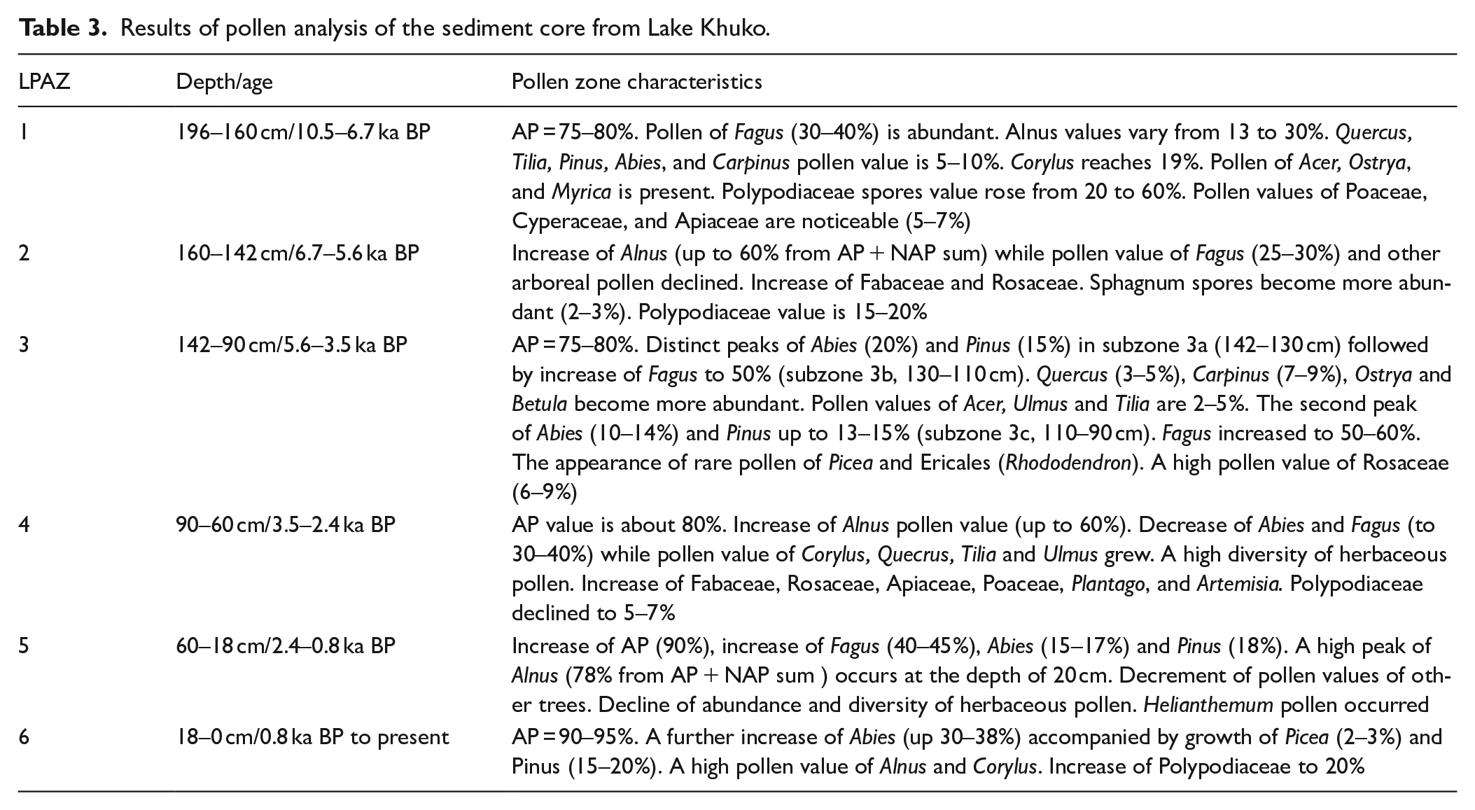
Pollen assemblages of the LPAZ 1 (196–160 cm/10.5–6.7 ka BP) are characterized by the abundance of Fagus (30–40%), relatively high participation of Quercus, Ulmus, and Tilia pollen and spores of Polypodiaceae with a small abundance of Abies and Pinus suggesting the wide distribution of forests, typical to the modern low and middle mountain zones. An increase in the proportion of Alnus pollen up to 60% from AP+NAP sum in LPAZ 2 (165–142 cm/6.7–5.6 ka BP) reflects an expansion of wet riverine forests of alder. Pollen value of Fagus declined to 25–30%, and other arboreal pollen became less abundant. Also, the growth of the proportion of Sphagnum mosses in the spectra may signify an increase in soil moisture.
The changes in the ratio of the components of the pollen assemblages in LPAZ 3 (142–90 cm/5.6–3.5 ka BP) suggest an increase in the abundance of Fagus and Abies in the forest stands. (Subzone 3a, 5.6–5.0 ka BP), indicating a possible expansion of high-altitude beech forests. Pollen assemblages are characterized by distinct peaks of Abies (20%) and Pinus (15%) in followed by increase of Fagus to 50%. Subsequently Carpinus, Quercus, Tilia, and Ostrya become more abundant in forests (Subzone 3b, 5.0–4.2 ka BP). In the upper part of the LPAZ (subzone 3c, 4.2–3.5 ka BP) the proportion of Fagus (50–60%) and Abies (10–14%) in pollen assemblages indicate the next expansion of the high-altitude forests. Pollen of Rosaceae family, which proportion also increases in this pollen zone (to 6–9%), probably belongs to Prunus laurocerasus. Currently, it is abundant in the lower part of high-altitude brushwood and crooked forests.
The Fagus pollen decreased significantly in LPAZ 4 (to about 30%) (90–60 cm/3.5–2.4 ka BP) and Abies disappeared. At the same time, there was an increase in Quercus, Ostrya, Betula, and Corylus pollen. Probably, plant formations characteristic of the mid-mountain and low-mountain zones occupied areas at a higher altitude than at present. Consequently, the pollen of their forest-forming species began to enter the lake in greater numbers. A relatively high peak of Alnus pollen value (up to 60%) suggested an expansion of riverine forests of alder.
The proportion of Fagus, Abies, and Pinus pollen grew in LPAZ 5 (60–18 cm/2.4–0.8 ka BP) indicating a shift of the lower boundary of alpine beech, beech-fir, and pine forests. Pollen values of Fagus reached 40–45%, proportions of Abies and Pinus increased to 15–18%. Pollen of Helianthemum, a typical plant of subalpine and alpine meadows, frequently occurred in this zone. At the same time, the participation of Quercus, Tilia and other species characteristic of the middle and lower vegetation belts of the mountains declined. An increase in Abies (up to 30–38%) and Pinus pollen frequencies (up to 20%) with a slight decrease in Fagus value in LPAZ 6 (18–0 cm/0.8 ka BP to present) indicates further development of fir and spruce forests, which are now characteristic of the upper zones of the mountains.
Overall, the pollen assemblages from the Lake Khuko sediment core are dominated by Fagus and Alnus pollen. Currently, beech largely dominates the forest in the vicinity of the lake, but is also regionally abundant at all altitudinal zones of vegetation and the same was presumably the case in the past. The modern pattern of vegetation in the area surrounding to Lake Khuko suggests that Fagus was a dominant taxon throughout the Holocene, alongside this the increase in Abies, Picea, Pinus, and Acer pollen may indicate climate cooling in this region. Currently, Abies nordmanniana typically occurs in beech forests in the upper mountain zones of the forest belt whereas the uppermost zones are often formed by Pinus sylvestris, P. hamata, Abies nordmanniana, and Picea orientalis woodlands. Therefore, an increase in Abies pollen frequencies and the appearance of Picea in assemblages while the proportion of other arboreal pollen declined may be interpreted as both a downshift of the boundary of this vegetation zone and an increase in the area of such formations. On the other hand, a rise of Qurcus, Ulmus, Tilia, and Carpinus percentages could indicate warmer conditions and expansion of forests typical to the lower and middle mountain forest zones. However, possible vertical movement of pollen between altitudinal vegetation belts needs to be taken into account and studies of recent pollen assemblages from mountain lakes in Georgia by Kvavadze and Efremov (1995) revealed that a high proportion of pollen derives from vegetation belts lying below.
The proportion of Alnus in the pollen assemblages from Lake Khuko sediment core varies 13–74% from the AP + NAP sum. Alder is currently widespread along floodplains in the mid-mountain and low-mountain forest zones (Komarova, 2017). However, since this species has high pollen productivity and the ability to be transported by the wind over long distances (Broström et al., 2008), the high abundance of its pollen in the assemblages is a pattern observed in many other high altitude lakes of Caucasus (Connor and Kvavadze, 2009; Messager et al., 2013, 2020). According to Kvavadze and Efremov (1995), in the medium-size lakes as Lake Khuko pollen of Alnus could partially originate from the atmospheric pollen rain coming from a large area. Therefore, we excluded Alnus from pollen sum to avoid it influencing the proportion of forest forming trees.
Discussion
The results of the study allow us to reconstruct the lake paleoenvironment and vegetation history in the adjacent area (Figure 6). Our results showed that the sediment accumulation rate in the Lake Khuko was relatively stable during most of the Holocene and that the sediment sequences revealed no hiatus or landslides caused by extreme or catastrophic (e.g. seismic) changes. The grain size analysis, magnetic susceptibility and loss on ignition records were measured sequentially every 1 cm segment of the core (every 1 cm), so the resolution of these data was roughly 50–100 years. Our palynological records had lower temporal resolution (about 500 years) due to a larger (10 cm) sampling interval. In the present study, we used pollen data to determine a general trend for vegetation and climate dynamics during the Holocene while the short-term fluctuations were identified by high-resolution data from other proxies. For discussion we subdivide the proxy records into five periods: 10.5–6.7 ka BP, 6.7–5.5 ka BP, 5.5–3.5 ka BP with subphases, 3.5–2.4 ka BP, and the last 2.4 ka BP subdivided into three subphases: 2.4–0.8 ka BP, 0.8–0.5 ka BP and 0.5 ka BP to present.
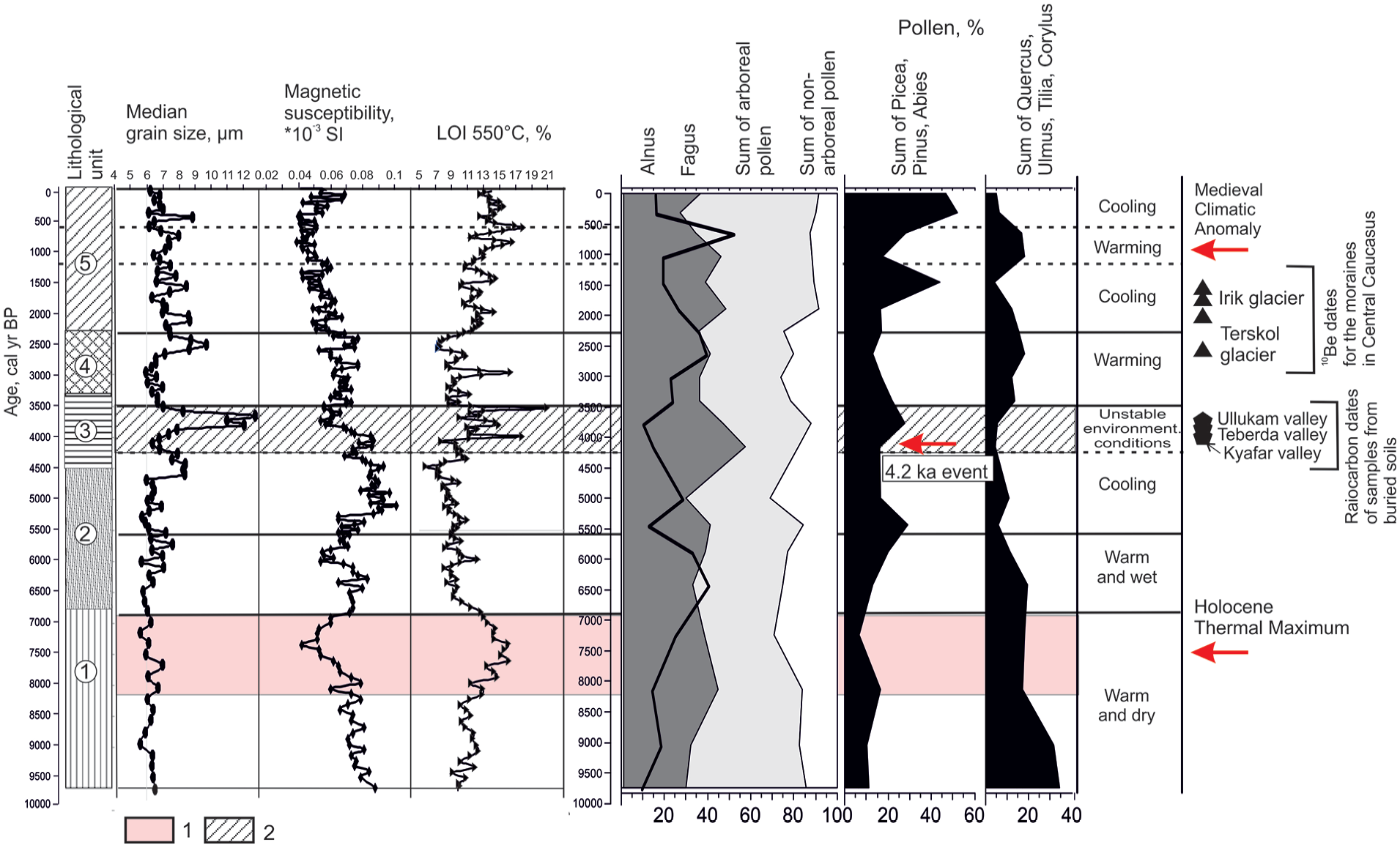
The main results of multi-proxy studies the sediment core from the lake Khuko including the median grain size, magnetic susceptibility, LOI550°C and characteristic pollen taxa, and the main phases of the Holocene climate changes.
The pollen record revealed a very forested and stable vegetation history throughout the Holocene suggesting a favorable climate and negligible human impact. The lake is sufficiently far from the edge of the tree line and was not part of the alpine zone during cool periods within the Holocene. Climate at this location generally stayed sufficiently warm and moist favoring forest vegetation since the early Holocene.
The Early\Middle Holocene (10.5–6.7 ka BP)
Similar to other high and mid-latitude regions of the Northern hemisphere (Davis et al., 2003; Lecavalier et al., 2017; Marcott et al., 2013; Mauri et al., 2015) this was the warmest period in the Western Caucasus. This period corresponds to the accumulation of the lithological unit 1, which is characterized by the lowest accumulation rate within the past 10.5 ka. This is probably the evidence of rather dry conditions in this location. Decrease in climate moisture and regressive phases of the lakes in this time were reported in several studies from different region of Caucasus (Connor and Kvavadze, 2009; Connor et al., 2018; Joannin et al., 2014; Messager et al., 2013, 2020).
From the curves of LOI550°C, LOI950°C and magnetic susceptibility revealed from Lake Khuko, we can clearly see two separate periods dating back to 10.5–8.0 and 8.0–6.7 ka within this interval. The two curves are opposite and agree very well with each other all over the records, but especially in this interval, showing a rate of high organic matter accumulation and apparently lower rate of accumulation of mineral fraction between ca. 8.0 and 6.7 ka. An abundance of fine plant detritus in the sediment unit together with high LOI550°C suggests an increase of biological productivity in the lake between 8.0 and 6.7 ka BP, possibly from climatic warming. Despite the low resolution of pollen records for the period 8.0–6.7 ka BP (only three samples), our results indicate warm climatic conditions during this time. A relatively high amount Quercus, Ulmus, Corylus, and Tilia pollen in the assemblages suggests wider areas of forests typical to the modern low and middle mountain zones than nowadays. During the Early Holocene broadleaved thermophilic tree species which survived in glacial forest refugia located in the Colchis lowland, spread eastwards and occupied mountains bordering the lowland (Connor and Kvavadze, 2009).
The evidence of warm climatic conditions in the study area between 8.0 and 6.7 ka BP broadly agrees with paleoclimatic reconstructions from other parts of the Caucasus. According to paleofloristic studies, the mean annual and July temperatures in Eastern and Southern Georgia during this period were estimated to be 6°C higher than today, with annual precipitation exceeding modern values by 200–400 mm (Kvavadze and Connor, 2005). Pollen based paleoclimatic reconstruction from the peatland Zarishat (the Lesser Caucasus, north-western Armenia) indicated the Mid-Late Holocene temperature of the coldest month was 6°C greater than today, whereas the annual precipitation was about 170 mm greater (Joannin et al., 2014). The Lake Van palaeoclimatic record (Wick et al., 2003) using oxygen isotope analyses suggested the warmest phase at the same time. Knyazev et al. (1992) suggested that the period 7.5–5.5 14C kyr BP (uncalibrated, corresponding to 8.4–6.3 ka BP) was warm based on palynological records from three sites in the Northern Caucasus. According to Ryabogina et al. (2019), the climate in Dagestan (the Northern Caucasus) was warm and dry between 9.2 and 7.3 ka BP. The synthesis of pollen data provided by Connor and Kvavadze (2009) for mountain areas in Georgia shows that modern subalpine zones were more forested by deciduous trees during the Mid Holocene. This assessment corresponded with the palynological results of Serebryaniy et al. (1980, 1984) who identified the maximum warming in the Caucasus during the Holocene Atlantic period, when, according to his estimates, the tree line was 300 m higher than at the end of 20th century.
The time period of 6.7–5.6 ka BP
After 6.7 ka BP the sediment accumulation rate in Lake Khuko increased two-fold which together with the increase of magnetic susceptibility values indicate more intensive sediment removal from the catchment area in comparison to the previous time due to the increase in climate wetness. A short peak of organic matter accumulation and a spike in magnetic susceptibility around 5.7–6 ka BP probably marks a warm period. According to obtained palynological results, the climate in Western Caucasus was still warm, but became wetter. An increase in the proportion of Alnus pollen during the period 6.7–5.6 ka BP (LPAZ 2, Figure 5), likely reflects an increase in climate humidity. At present, alder forms wet riverine forests in the low and mid-mountain zones. Also, an increase in the proportion of Sphagnum mosses in the spectra may serve as a sign of an increase in soil moisture. The suggestions of an increase of climate wetness in the area around Lake Khuko agree well with the finding of Leroyer et al. (2016) in the south-eastern shore of Lake Sevan, Armenia, who identified an increase in annual precipitation. An increase in humidity is also suggested by rapid afforestation in the Lesser Caucasus (Connor and Kvavadze, 2009; Joannin et al., 2014; Messager et al., 2013). Ryabogina et al. (2019) reported a warm and humid climate in Dagestan (Northern Caucasus) at 7.3–6.0 ka BP. On the contrary, Serebryaniy et al. (1984) suggested a cooling in Central Caucasus between 7.4 and 4.8 ka BP, but the low resolution and insufficient chronological control of this record does not allow a direct comparison with our results for this time interval.
The time period of 5.6–3.5 ka BP
Climatic reconstructions for Europe and Northern Eurasia indicated a progressive cooling from about 5.7–5.5 ka BP (Davis et al., 2003; Mauri et al., 2015), along with increases in humidity and glacial advances (Wanner et al., 2008). A consistent decrease in organic matter content in Lake Khuko with a significant rise of magnetic susceptibility values between 5.6 and 4.2 ka BP suggests low productivity of lake biota and, probably, high rates of erosion in the area adjacent to the lake. The changes in pollen assemblages (for instance peaks of Abies and Pinus) suggest a cooling of the climate and potential lowering of the boundaries of vegetation belts. In mountains surrounding the Colchis Lowlands, forests with Picea orientalis and Abies nordmanniana become widespread during this time (Connor and Kvavadze, 2009; Connor et al., 2018). Kvavadze and Efremov (1996) reported that at 4.3–4.2 14C kyr BP (around 4.7 ka BP) in the Arkhyz Valley of the Western Caucasus some radical climate changes begun, namely the alpine belt descended by several hundred meters due to intense and prolonged cooling interrupted by one warming episode. Pollen based climate reconstructions from the peatlands in Armenia (Lesser Caucasus) showed a significant shift in climate conditions at ca. 5.7 ka BP, specifically decreases in both winter temperature and annual precipitation (Joannin et al., 2014; Leroyer et al., 2016). A long-term cooling trend was also detected in paleoclimatic record from Lake Van in eastern Anatolia (Wick et al., 2003). In the Northern Caucasus, Ryabogina et al. (2019) identified a substantial increase in the proportion of the arboreal pollen and the beginning of conifer predominance in Dagestan between 6.0 and 3.8 ka BP, that they also interpreted as climate cooling and humidification.
Noticeable changes in the Lake Khuko ecosystem occurred in the period 4.2–3.5 ka BP. These changes were marked by a short-term (with duration of 100–200 years) and sharp variation in LOI550°C from 9% to the maximum rates the entire Holocene at about 20%, as well as changes in other indicators. This phase was terminated by the input of fine sand into the lake, which led to an increase of the median grain size value up to the maximum value of 12.8 µm. These significant changes in sediment accumulation rate could have resulted from vegetation and soil disturbances, such as fires or from short-term climatic fluctuations between dry phases and phases with raised precipitation and runoff into the lake. Detailed charcoal analysis (Kupriyanov and Novenko, 2019) is planned as the continuation of the present study to deduce the history of forest fires in the Lake Khuko region. There are no archeological findings in the vicinity of Lake Khuko and no direct palynological indicators of human impact in pollen assemblages, so we suggest natural reasons for these paleoenvironment changes. The beginning of this phase coincided with the so-called 4.2 ka event, lasting for two or three centuries that was identified as an arid phase in low- and mid-latitude regions, but in high northern latitudes the 4.2 ka event was characterized by colder conditions and glacial advances (Solomina et al., 2008; Wanner et al., 2008). We could not directly link the instability phase in Lake Khuko (4.2–3.5 ka BP) to the 4.2 ka event, but the changes were possibly caused by a complex shift of the ocean-atmosphere system during this event (Bradley and Bakke, 2019). Several uncalibrated 14C dates of buried soils reported from the high elevation localities in the Western Caucasus indicated warmer and probably drier conditions than nowadays (e.g. in Ullukam valley (Solomina et al., 2016a): 3580 ± 80 14C yr BP (calibrated 3.9 ka BP), in Kyafar (Kovaleva, 2009): 3720 ± 140 14C yr BP (4.1 ka BP), horizon B of modern soils in Teberda valley, Khatipara site (Pavlova and Opinchenko, 1992; Solomina et al., 2013): 3610 ± 80 14C and 3630 ± 60 14C yr BP (3.9 ka BP).
The mid/late Holocene, 3.5–2.4 5 ka BP
An increase in thermophilic plants, especially broadleaved trees, indicates warming in the Western Caucasus according to the Lake Khuko records. It is possible that this period, in fact, included several shorter warm and cold episodes that were not captured by our pollen data. The LOI550°C curve shows a peak at 3.0 ka BP, marking the abundance of organic material probably related to warmer conditions. A warm and dry phase with high fire activity was detected between 3.7 and 2.7 ka BP in the East European Plain (Novenko et al., 2019). Lake Luganskoye (B. Laba valley, Western Caucasus) was transformed into a peatland between 3.2 and 2.8 14C kyr BP (3.4–2.9 ka BP) potentially due to the warming of climate and decrease of humidity (Davydova, 1995).
The late Holocene, 2.4 ka BP to present
According to pollen data from Lake Khuko, climatic cooling began at ca. 2.4 ka BP in this region. This corresponded to the global temperature decline in Northern Eurasia, which was mainly due to the reduction of summer insolation from 2.7 to 2.6 ka BP (Mauri et al., 2015; Wanner et al., 2008). However, this general trend to colder climatic condition was interrupted by a warmer phase between 0.8 and 0.5 ka BP. In the Lake Khuko sediment sequences this period coincided with the accumulation of the upper lithological unit – gray organic rich silt, diffuse laminated with eight pairs of darker and lighter bands, which suggests changing conditions of sedimentation in the lake. The median grain size and organic matter content tended to increase during this period indicating more intensive sediment load into the lake from the adjacent area and higher productivity of the lake ecosystem in comparison to the previous phase. The increase in coniferous pollen and frequent occurrence of Helianthemum, a common species of subalpine and alpine meadows in Lake Khuko pollen records during the period 2.4–0.8 ka BP, suggest a downshift of the upper timberline in the study area and climate cooling. The first 10Be dates for the moraines of Central Caucasus obtained by Solomina et al. (2019) also point to several Neoglacial glacier advances at that time most probably forced by temperature decrease (Terskol glacier 2700 ± 400, 2100 ± 50 years BP; Irik glacier 1820 ± 200 years BP, 1670 ± 200 years BP). Progressive cooling in Lesser Caucasus was recorded in paleoclimatic reconstructions based on different proxies (Joannin et al., 2014). Kvavadze and Efremov (1996) identified four cold and four warm episodes over the past 1.6–1.8 ka BP, although they cautioned that time resolution of their reconstruction is not enough to specify the chronological boundaries of these periods.
The general trends of the last millennium are quite well understood and described in a number of publications (e.g. PAGES 2k Consortium, 2013 and reference therein). It consists of three distinct periods: Medieval Climatic Anomaly (MCA, ca. 900–1350 AD/1.05–0.60 ka BP), Little Ice Age (LIA, AD 1450–1850/0.5–0.1 ka BP), and the modern warming. The LOI550°C and magnetic susceptibility parameters roughly reproduce this pattern. The organic matter content increased between 0.8 and 0.5 ka BP and the abundance of Quercus, Tilia, and Corylus increased in pollen assemblages; however, pollen data are too rough to identify the warming of the MCA. Progressive cooling after 0.5 ka BP was indicated by the peak of Fagus followed by the rise of Abies, Pinus, and appearance of Picea. Probably, climatic cooling during the LIA encouraged the downward movement of beech-fir forests with the participation of Pinus sylvestris, P. hamata, and Picea orientalis, typical for modern high-altitude woodlands near the timberline. An increase of the magnetic susceptibility value in the sediment sequences of Lake Khuko during the last 500 years could be a sign of the higher intensity of runoff or erosion of mineral soils in comparison to the previous phase.
The high-resolution pollen data and chemical element composition (Br) of the sediment sequences from Lake Karakel show the warm period at AD 750–1200 corresponding with the MCA and three LIA cooling phases in AD 1250–1400, 1500–1630, and 1750–1880 (Chepurnaya, 2014; Solomina et al., 2014).
Conclusion
Our multi-proxy reconstruction based on grain size analysis, magnetic susceptibility, loss on ignition measurements, and pollen analysis of a sediment core from Lake Khuko provide new insights into the Holocene environment and climate history in the Western Caucasus. The results suggest that changes in the lake ecosystem and mountain vegetation dynamics in the area adjacent to the lake were mostly driven by variations in climate. As shown by pollen data, the lake was surrounded by forest throughout the Holocene and despite climatic fluctuations forest vegetation persisted in the area. No human impact was detected. According to the evidence from this study, the Holocene Thermal Maximum occurred in the Western Caucasus between 8.0 and 6.7 ka BP and was characterized by warm and dry conditions, the highest biological productivity of the lake during the entire Holocene, and expansion of forests, typical to the modern low and middle mountain zones. During the period 6.7–5.6 ka BP the climate became wetter, however, conditions remained warm. Progressive cooling and an increase in humidity occurred after 5.7–5.5 ka BP, consistent with decreases in organic matter content in the sediments and possibly higher intensity of sediment removal from the catchment area of the lake. The changes in pollen assemblages at about 5.6 ka BP (e.g. peaks of Abies, Picea, and Pinus that form high-altitude woodlands) suggest a potential lowering of the boundaries of vegetation belts. The analysis reveals a general cooling trend during the second half of the Holocene along with several warmer phases (at 3.5 and 0.8 ka BP) and colder phases (at 2.5 ka BP and 0.5 ka BP).
A phase of drastic changes in the lake ecosystems was identified between 4.2 and 3.5 ka BP that was marked by short-term (with duration of 100–200 years) and sharp variation in organic matter content, magnetic susceptibility values, and sediment grain size. Although the beginning of this phase coincided with the 4.2 ka event, there is not sufficient evidence for a direct link between the changes in Lake Khuko and this event. Nevertheless, we supposed these notable changes in sediment accumulation could have resulted from vegetation and soil disturbances, such as fires or short-term climatic fluctuations in the Western Caucasus, probably, caused by a complex shift of the atmospheric circulation during the 4.2 ka event.
Further study of the promising climatic archive from Lake Khuko, namely detailed pollen, diatom, and macro-charcoal analyses, will provide a valuable contribution to the understanding of natural processes in the region, including ecosystem response to current climatic changes.
Footnotes
Acknowledgements
This work was performed in the framework of the State Task No. 0127-2019-0008 “Markers of natural events in high-resolution sedimentation paleoarchives” (analytical work at the Institute of Geography RAS: magnetic susceptibility, loss on ignition, grain size measurements). We thank the Russian Foundation for Basic Research (Project No. 17-05-01170) and the Russian Science Foundation (Project No. 19-17-00181) for support. We are grateful to the Administration of the K.G. Shaposhnikov Caucasus State Natural Biospheriс Reserve for fieldwork assistance, logistical support, and participation. The authors thank Logan Berner (EcoSpatial Services L.L.C., USA), who kindly assisted with English language editing of the manuscript, which improved the clarity. We are greatly indebted to the two Anonymous Reviewers and Prof. Viv Jones, who supplied very important guidance for drastically improving the manuscript with their very helpful detailed comments.
Funding
The author(s) disclosed receipt of the following financial support for the research, authorship, and/or publication of this article: This work was supported by the Russian Foundation for Basic Research, Project No. 17-05-01170 (sample preparation, pollen analysis) and the Russian Science Foundation, Project No. 19-17-00181 (dating, age model preparation, writing the original manuscript, working on the revision of the manuscript).
