
Abstract
Peatlands store massive amounts of organic carbon, but the fate of this carbon remains unclear as global climate continues to warm. The age of peatland inception and the main drivers of peat initiation are one of the most important issues in Holocene paleoecology, especially for the numerous but under investigated peatlands in European Russia. This paper introduces new peatland initiation ages for 44 mires in three areas located in the central part of European Russia within the Polesie landscape belt. This region is characterised by waterlogged sandy plains and flat surface topography. Phases of peatland initiation were compared with Holocene fire regime derived from macro-charcoal data as well as with regional climatic reconstructions. We found that peat inception in the region started around 12,000 cal yr BP, but the most active phases of peatland initiation took place during the periods 8500–7500, 7000–6000, 5300–5800, 4000–3500 and 1700–1200 cal yr BP. Expect for rapid peat growth during the early Holocene, peatland initiation mostly coincided with warm climatic periods and increased fire frequency. Forest soil paludification in poorly drained Polesie landscapes was presumably enhanced by reduced evapotranspiration and changes in water balance due to disturbance of forest cover after wildfires. We expect that rising air temperature in the current century will cause higher fire frequencies and may encourage waterlogging of forests and ecosystem transformation.
Introduction
Peatland development and their possible responses to environmental changes and human impact during the Holocene are a key focus of palaeoecological studies due to the very important role of peatlands in the global carbon cycle (Charman et al., 2013, 2015; Feurdean et al., 2019; Lunt et al., 2019; Mauquoy and Yeloff, 2008; Payne et al., 2016; Turetsky et al., 2015; Yu, 2006, 2011). Boreal and arctic peatlands occupy large areas of the Earth and act as an especially important natural carbon sink as plants remove carbon dioxide from the atmosphere and incorporate the carbon into organic matter. Carbon sequestered in peatlands accounts for about 1/3 of total global soil carbon (Gorham, 1991; Loisel et al., 2014; Reichle, 2020; Yu, 2012). Water saturated soils and anaerobic conditions in peatlands also contribute to generation of methane, which is an important green-house gas affecting modern global climate changes. Total modern methane emissions from peatlands account for about 10% of global methane emissions from all natural and anthropogenic sources (Korhola et al., 2010; Schuldt et al., 2013).
During the last several decades numerous studies analysed carbon accumulation rates in peatlands during the Holocene in regions of Northern America and Eurasia; however, the main drivers of peat initiation as well as the age of peatland inception have not been thoroughly investigated and remain an important challenge (Camill et al., 2009; Charman et al., 2013, 2015; Kirpotin et al., 2007; Loisel et al., 2014; Lunt et al., 2019; Yu, 2012). Recently published basal radiocarbon dates from peatlands in the Northern Hemisphere indicate that most northern peatlands rapidly expanded between 12,000 and 8000 cal yr BP (Dendievel et al., 2020; Korhola et al., 2010; MacDonald et al., 2006; Morris at al., 2018; Yu, 2012; Zhao et al., 2014). Morris et al. (2018) analysed an extensive database of peatland basal ages and regional climatic conditions during peatland initiation using numerical experiments with general circulation models, and showed that the initiation of peatlands in the regions formerly covered by ice sheets was primarily driven by climatic warming. In landscapes that were in the periglacial zone during the last glacial period, peat initiation was also influenced by increased precipitation and more humid climate (Morris et al., 2018). Wildfires are mentioned as an important factor affecting peatland inception especially in the case of large-scale paludification of boreal forests (Turetsky et al., 2015; van Bellen et al., 2012).
Most studies conducted over the last decades focused on arctic and northern boreal regions, and particularly on the most extensive peatland areas such as Western Siberia and the Hudson Bay Lowlands (Borren et al., 2004; Kirpotin et al., 2007; Lafleur et al., 2015; ; Payette et al., 2013; Simard et al., 2007, 2009). On the other hand, the largest peatland areas situated in the southern part of the boreal forest zone remain very poorly investigated in both Europe and North America.
Our current study focuses on a belt of so-called Polesie landscapes, which extends as a wide band across the East European Plain from the Pripyat River basin to the Urals mountains. These landscapes formed on sandy fluvioglacial deposits and are characterised by flat topography and prevailing high ground water levels that promote active peatland development (Nikolayev, 2013). Waterlogged pine forests and mires occupy 30%–35% of the area (Zeidelman, 2013). Evidence of peatland inception is still based on fragmentary data about peat stratigraphy and chronology. Shallow mires with a very limited number of high temporal resolution records predominate in the area. The few available radiocarbon dates indicate that peatland basal age in the area ranges from 10,000 to 4500 cal yr BP (Abramova 1999, Bolikhovskaya, 1988; Dobrowolski et al., 2010, Novenko et al., 2016, 2018). In the present study we brought together radiocarbon dates from 44 paludified peatlands in three model areas located in the central part of European Russia within the Polesie landscape belt to identify the peatland inception time and to detect possible influences of various climatic factors and fire events on peatland initiation and forest soil paludification during the Holocene.
Study area
Three study areas representing landscapes of the Polesie type were investigated (Figure 1). The first two areas were in the Ryazan region (Klepikovsky district) within the Meshchera Lowlands. The study areas were located in the vicinity of the Lesunovo and Beloe Lake research stations, which are operated by the Department of Physical Geography and Landscape Science in the Faculty of Geography at Lomonosov Moscow State University. Landscapes properties, vegetation history and the structure of Quaternary deposits of the area are well summarised in previous studies (Abramova, 1999; Annenskaya et al., 1983; Ivanov, 1995; Novenko et al., 2016). The study areas were named according to the names of these research stations. The third study area was situated in the territory of the P.G. Smidovich Mordovian State Natural Reserve (Temnikovsky district of the Republic of Mordovia). It belongs to the Moksha Polesie, which is a south-eastern extension of the Meshchera Lowlands (Nikolayev, 2013). The vegetation, soils, peatland, environmental conditions and fire history in this area were intensively explored during the last decades (Grishutkin, 2012; Novenko et al., 2018; Vargot, 2016).
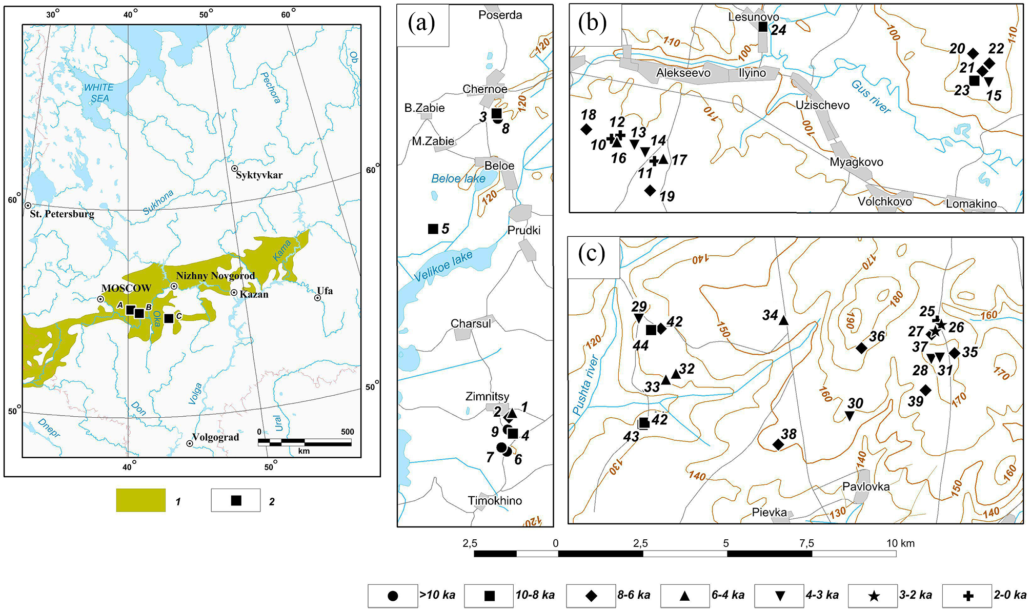
Location of the Polesie landscape belt and study areas. 1 – Polesie landscape belt (according to Nikolayev, 2013); 2 – location of study areas: (a) Beloe Lake, (b) Lesunovo and (c) Mordovian State Natural Reserve.
The radiocarbon dates of peatland basal layers in three study areas*.

Material for dating was bulk peat in all samples.
The Beloe Lake study area was situated in the central and most waterlogged part of the Meshchera Lowlands (Figure 1(a)). The topography of the region is represented by almost flat, poorly drained, fluvioglacial and lacustrine plains with average altitudes of about 120 m a.s.l. (above sea level). The area belongs to a large Middle Pleistocene basin of glacial melt water runoff, which inherited a pre-Quaternary erosion depression (Annenskaya et al., 1983). During the Late Pleistocene glacial epoch this basin was occupied by a large lake. A chain of modern relatively large (630–960 ha) and small (less100 ha) lakes, which are connected by the Pra river, are the remains of that former great lake. The Lesunovo study area was located 50 km south-east from Beloe Lake within the Gus’ River basin, which, similar to the Pra River, is a tributary of the Oka River (Figure 1(b)). The hilly landscape of the area is represented by Early-Middle Pleistocene moraine-fluvio-glacial plains and eolian-fluvio-glacial hilly plains with elevation 110–125 a.s.l. Gentle sandy ridges occupy the elevated sites of the area.
The third study area was situated in the south-western part of the Mordovian Natural Reserve (Figure 1(c)) within the floodplain of the Pushta River. The Pushta River is a tributary of the Moksha River in the middle Oka river basin. It is an undulating plain with elevation 120–190 a.s.l. that was formed from the moraine of the Don Glaciation and the Early and Middle Pleistocene fluvio-glacial deposits.
The study areas have a humid continental climate with warm summers (Dfb) according to the Koeppen – Geigen climate classification (Geiger, 1954). The mean annual air temperature in the Meshchera Lowlands is 4.9°C, while the mean temperatures of the coldest and warmest months are −8.0°C and 18.7°C respectively. The mean annual precipitation reaches 590 mm (Cherusti weather station; 1981–2010; https://meteoinfo.ru). Observations from the Temnikov weather station near the Mordovian Natural Reserve show that mean annual temperature is close to 5.1°C (period 1981–2010), which is slightly higher than in the central part of Meshchera Lowlands. The mean temperature in January is −8.6°C and the mean temperature in July is 19.6°C (https://meteoinfo.ru). Annual precipitation is around 540 mm.
Soils in the study areas are Albic Podzols according to the World Reference Base system (IUSS Working Group, 2014). Forests mainly consist of Scots pine (Pinus sylvestris L.) with an admixture of spruce (Picea abies L.), birch (Betula pendula Roth.) and aspen (Populus tremula L.). Alder (Alnus glutinosa (L.) Gaertn.) is common at wet locations along floodplains. Well-drained habitats with fertile soils in the Lesunovo area and in Mordovian Natural Reserve are occupied by mixed pine-deciduous forests with oak (Quercus robur L.), lime (Tilia cordata Mill.), elm (UImus glabra Huds.), maple (Acer platanoides L.) and ash (Fraxinus excelsior L.). Secondary forests of Betula pendula and Populus tremula are abundant in the Mordovian Natural Reserve, especially in places that were previously clear-cut (Tereshkin and Tereshkina, 2006).
Peatlands are common in the study areas due to moderately wet surface moisture conditions (Climate Moisture Index, CMI = 0.3–0.4) and the flat surface topography (Novenko et al., 2019; Olchev et al., 2020). Numerous peatlands are situated in former thermokarst depressions that appeared during the Last Glacial Maximum and in river floodplains (Ivanov, 1995). Large wetlands occupied lacustrine plains and the lake shore of the Beloe Lake. Peat bogs in deep sinkholes are typical in the Mordovian Natural Reserve (Grishutkin, 2012).
Materials and methods
We collected and analysed cores from 37 peatlands in three study areas. Additionally, we drew on radiocarbon dates from seven peat cores previously collected in the region (Novenko et al., 2016, 2018; Kupriyanov and Novenko, 2019). Thus, our analysis was based on paleoecological data from 44 peatlands within the study areas.
The peatlands were mainly small nutrient-poor fens or ombrotrophic bogs (from 0.5 to 12 ha) located in watershed areas and at river terraces. The thickness of peat deposits in the mires varies from 35 to 265 cm, but most peat sequences were about 100–120 cm in depth. Floodplain peatlands and mires in sinkholes, which are common in study regions, were excluded from analysis because they are strongly affected by local hydrological conditions and rivers that can suppress the climate signal in peat deposits.
Peat cores were extracted during field campaigns in 2016–2019 using a Russian peat corer (inner chamber length of 50 cm and diameter of 5 cm). The cores were described, photographed and sub-sampled for further analysis. Samples for radiocarbon dating of the peat initiation age were taken in peat cores from the deepest parts of mires. In the data set presented in this paper each radiocarbon date characterises a distinct peatland.
Radiocarbon dates for peat samples (Table 1) were obtained by liquid scintillation counting methods at the Radiocarbon Laboratory of the Institute of Nature Management of the National Academy of Science (Minsk, Belarus) and at the Center of Common Use Laboratory of Radiocarbon Dating and Electron Microscopy at the Institute of Geography of the Russian Academy of Science (Moscow, Russia). The 14C dates were calibrated using the program Calib 7.1. and the calibration dataset Intcal13 (Reimer et al., 2013). All calculations were done at 2σ level. The radiocarbon dates of peatland basal layers (n = 44) were pooled in a probability density analysis using the respective option in OxCal 4.3 in order to visualise the peat inception chronology on the Holocene timescale (Figure 2).
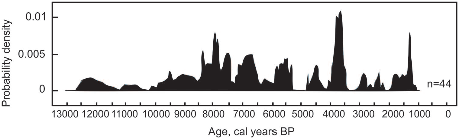
The cumulative probability density of calibrated 14C dates of the peatland initiation age in study areas.
Samples for plant macrofossil analysis (5–10 cm³ per sample) were disaggregated with water and washed through a 0.25 mm mesh sieve. The plant remains were identified using a binocular microscope at 200x magnification following standard techniques (e.g. Katz et al., 1977; Mauquoy and Van Geel, 2007). The results of plant macrofossil analysis were generalised into the following five peat types (Loisel et al., 2014): Sphagnum, herbaceous, woody, brown moss and humified peat.
In discussion of influence of fires on peatland initiation we used our previous reconstructions of fire free interval based on studies of charcoal layers in well dated peat cores from peatlands Novoaleksandrovskoe, Durnoe, Alexeevo, Bagul’nikovoe and Zhuravlinoe at Lesunovo study area (Novenko et al., 2016) and Klukvennoe-2 and Dolgij Most-2 in the Mordovian Natural Reserve (Novenko et al., 2018). The charcoal layers in these peat cores were described according to Pitkänen et al. (2001). The depth of each charcoal layer was measured immediately after sampling in order to detect the pattern of charcoal bands in the fresh, un-oxidised peat. The age of charcoal layers in each peatland were determined using age-depth models and fire free intervals were calculated based on the time interval between subsequent fires, as indicated by charcoal bands (Whitlock et al., 2010). Fire free intervals in the Beloe Lake study area were determined by macro-charcoal analysis (Higuera et al., 2007; Mooney and Tinner, 2011) of the peat core from the Studencheskoe mire (Kupriyanov and Novenko, 2019)
Results
Peatland initiation age
The age of basal peat layers in our study sites ranged from the pre-Holocene (calibrated weighted mean: 12,250 cal yr BP) to late-Holocene (1279 cal yr BP). The probability density plots of peatland initiation age (Figure 2) show that peaks of peat inception conspicuously occurred around 8500–7500, 7000–6000, 5300–5800, 4000–3500 and 1700–1200 cal yr BP. No peatlands formed during the periods 5300–4700 and 3500–3000 cal yr BP. The oldest peatlands with basal peat dates between 12,200 and 10,000 cal yr BP were situated in the Beloe Lake study area (Table 1). Four peatlands in this area formed before 10,000 cal yr BP, while the age of three peats ranged between 9000 and 8000 cal yr BP and the last two peatland started to grow during the period from 6500 to 5800 cal yr BP (Figure 3).
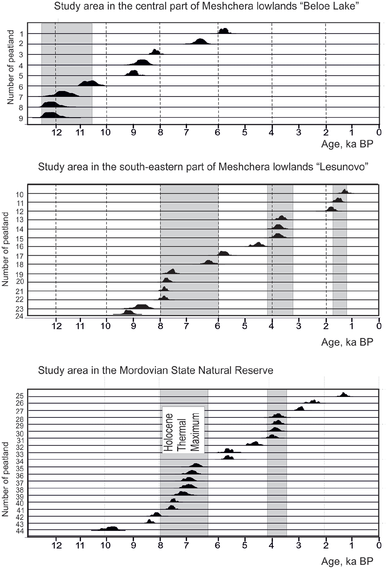
Distribution of the probability of calibrated 14C basal peat dates in study areas.
The peat inception age of the oldest mire in the Lesunovo study area was 9480 cal yr BP (Table 1). Peat formation of five peatlands began between 8000 and 6000 cal yr BP, three mires formed 4000–3500 cal yr BP and three formed 500 to 1200 cal yr BP (Figure 3).
The peatland initiation in the Mordovian Natural Reserve varied from 9779 to 1280 cal yr BP (Table 1). Basal peat dates from most of the peatlands in this area corresponded to the interval between 8000 and 6200 cal yr BP, while three corresponded to the period 4000–3500 cal yr BP (Figure 3).
Peat stratigraphy and charcoal layers
The mires were characterised by similar peat stratigraphy (Figures 4 and 5). The upper parts of the cores (15–30 cm) were formed by poorly humified Sphagnum peat. This part was separated from the underlying highly decomposed woody or woody-herbal peat by a distinct charcoal layer (0.5–1 cm thick). Radiocarbon dating of this boundary in twelve peatlands showed the age of charcoal bands in seven peatlands varied from 1700 to 30 cal yr BP. Samples from five peat bogs revealed high radiocarbon activity suggesting these layers originated after AD 1950 (Figures 4 and 5; detail of radiocarbon dating in Supplemental Appendix 1).
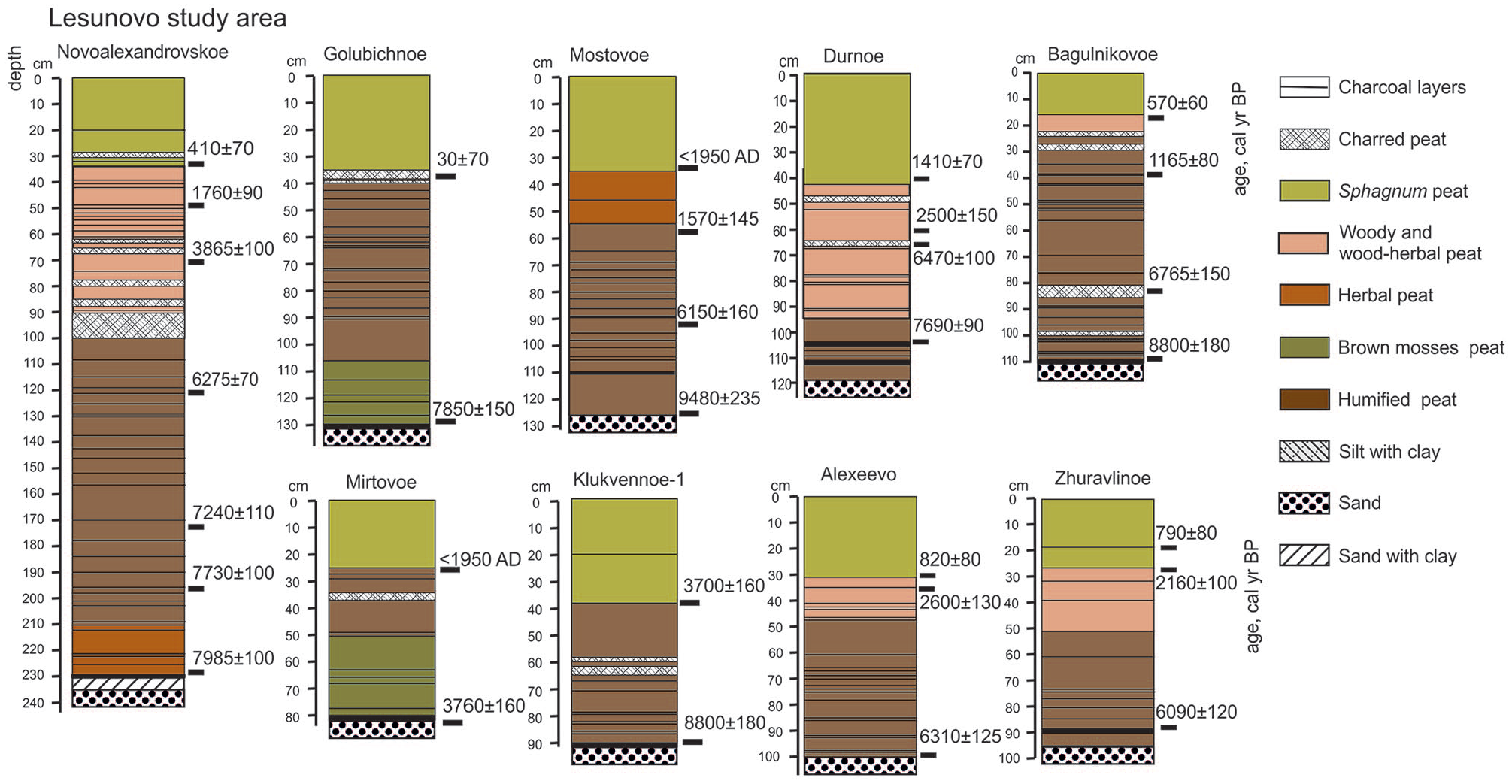
Stratigraphy of the peat deposits in the Lesunovo study area.
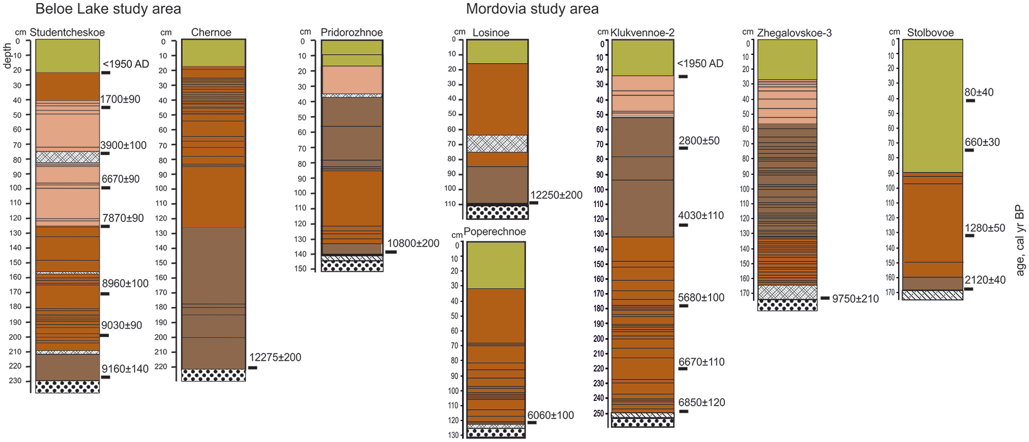
Stratigraphy of the peat deposits in the Beloe lake study area and in the Mordovian Natural Reserve.
The middle parts of the peat cores were represented by woody peat mainly formed from remains of Pinus sylvestris with minor portion of Betula and Salix, herbal peat contained Calamagrostis sp., Carex sp., Menyanthes trifoliata, Typha latifolia and Molinia caerulea and dark-brown humified amorphous peat. The thickness of layers ranged from 20 cm in shallow mires to 120 cm in the deepest ones. Brown mosses and herbal peat occurred in the low parts of the peat cores. In some peatlands the humified amorphous peat continued to the bottom.
Many charcoal layers (0.2–0.5 cm thick) were detected in each peatland, bands of charred peat with thickness 1–5 cm were commonly observed. The number of charcoal layers varies from 15–20 to 50–60 depending on the thickness of peat deposits. A distinct charcoal layer (1–2 cm thick) was evident at the base of the peat sequence in each sample plot with exception of peatlands Losinoe, Tichoe, Pridorozhnoe and Chernoe at the Beloe Lake study area and Mostovoe mire at the Lesunovo study area. Peat are underlain by fluvioglacial sands, sand with clay or silt with clay (Figures 4 and 5).
Discussion
Data on peat inception age from 44 mires located in three study areas within the Polesie landscape belt showed that peatland initiation in these regions took place throughout the Holocene (Figure 2). As was previously mentioned, the oldest peatlands with basal peat dates exceeding 11,000 cal yr BP were situated in the Beloe Lake study area (Figures 1(a) and 3), which is the most waterlogged central part of the Meshchera Lowlands. This stage of paludification is coincided with a rapid increase in global temperature and accelerated peat accumulation at the transition period from the Late Pleistocene glacial epoch to the Holocene (Morris et al., 2018). According to an available large data set of radiocarbon dates for basal peat layers in the northern parts of Eurasia and Canada (Korhola et al., 2010; MacDonald et al., 2006), the majority of peatlands formed between 11,000 and 9000 cal yr BP. This time interval includes peat inception ages of five peatlands in the Beloe Lake study area and two mires at the Lesunovo study area. However, most peatlands appeared between 8500 and 5800 cal yr BP during the Holocene Thermal Maximum. Evidence of active paludification during this period has been found in many regions of European Russia and Western Siberia (Borren et al., 2004; Kirpotin et al., 2007; Minayeva et al., 2006; Yelina, 1997). For example, in Karelia, about 40% of wetlands formed during this period (Inisheva et al., 2013). The beginning of peat accumulation also occurred from 8000 to 7300 cal yr BP in a large number of peatlands in southern Finland (Korhola, 1995). Although radiocarbon dates for basal peat layers from watershed peatlands in other Polesie regions in Europe are scarce, two existing dates fall within the interval between 8500 and 5800 cal yr BP. These data originated from the area of Orlovskoe Polesie National park in the Upper Oka River basin (Volkova et al., 2020): 7300 ± 40 cal yr BP (6380 ± 80 14C yr BP, IGAN 4666) and 8250 ± 75 cal yr BP (7390 ± 80 14C yr BP, IGAN 4668). Studies of deposits filling small closed depressions in the Western Polesie region in Poland and Ukraine have shown the beginning of peat accumulation widely ranged from 9000 to 5000 cal yr BP (Dobrowolski et al., 2010).
Climatic reconstructions closest to the study area were made in the Klukva peatland (Tula region) situated in the north-western part of Mid-Russian Uplands about 300 km to the South-West from our study area (Novenko et al., 2015, 2019). Mean annual air temperatures, annual precipitation, and CMI were inferred from pollen data and peatland surface wetness (expressed as water table depth) revealed from testate amoebae transfer function (Novenko et al., 2019). These regional climatic reconstructions indicated warm and relatively wet climatic conditions between 8500 and 7500 cal yr BP (Figure 6). Mean annual temperatures were 1.0–2.5°C higher than present, while precipitation exceeded modern values by about 200 mm and CMI was about 0.3 during the period around 7500 cal yr BP.

Comparison of periods with active peatland initiation with climatic reconstructions inferred from pollen and testate amoebae data from peatland Klukva (after Novenko et al., 2019) and fire frequencies at Lesunono study area (after Novenko et al., 2016) and in Mordovian Natural Reserve (after Novenko et al., 2018).
Warm and wet climate encouraged peat accumulation, as evident by eight peatlands from our data base forming between 8500 and 7500 cal yr BP. Previously estimates of vertical peat growth based on radiocarbon dates from seven peatlands demonstrated a high peat accumulation rate (1.0–1.5 mm/year) during that time (Novenko et al., 2016, 2018). However, the maximum number of peatlands in our study (n = 13) formed during the late phase of the Holocene Thermal Maximum between 7500 and 5800 cal yr BP, when climatic conditions became significantly drier as demonstrated by surface moisture indicators (Figure 6). CMI decreased to 0–0.1 (mildly wet conditions) during this period. Reconstructed water table depths in mires fell to 15 cm, probably due to reduced summer precipitation and/or greater evapotranspiration (Novenko et al., 2019).
The next distinct period of peat inception (detected for seven peatlands) was dated to the period between 4200 and 3200 cal yr BP, which according to climate reconstructions was the driest period for the entire Holocene. Mean annual precipitation decreased to modern levels while temperatures remained somewhat higher than at present (Figure 6). The lowest value of CMI = −0.1 (mildly dry condition) and the deepest water table level recovered from the Klukva peatland suggested much dryer climatic conditions than at present. The high degree of peat humification revealed from several peat cores from Polesie regions (Novenko et al, 2016) suggest summer moisture deficit in these peatlands during this period. The last interval of peatland initiation between 1700 and 1200 cal yr BP occurred during variable climatic conditions that tended towards cooling and increased precipitation.
It should be noted that few peatlands appeared in the region during periods of cooling and increased moisture – about 5700–4500, 3500–3000 and 2600–2000 cal yr BP. A similar tendency of decreased peat accumulation rate and low intensity of peat inception is evident for many regions of the Eastern European plain and Western Siberia (Borren et al., 2004; Inisheva et al., 2013; Yelina, 1997). However, opposite trends of peatland initiation and expansion are evident if we take into consideration data from 3146 circumarctic basal radiocarbon peat dates from 2212 sites compiled by Korhola et al. (2010). During the Holocene Thermal Maximum between 8800 and 5800 cal yr BP the intensity of peat inception significantly decreased. After 5800–5500 cal yr BP, climate conditions became progressively cooler and wetter (Davis et al., 2003; Mauri et al., 2015) which resulted in more active paludifiction processes. Similar trends were identified in several studies in the middle and south taiga areas within the East European Plain (Glushkov et al., 2016; Minayeva et al., 2006; Payne et al., 2016).
Comparison of basal peat dates with reconstructions of peatland fire frequency from charcoal layers in peat cores (Dyakonov et al., 2017, Novenko et al., 2018) shows that the peat inception of most localities in the study area partially coincided with periods of increased occurrence of fires (Figure 6). In the Lesunovo study area there were six periods with high fire frequency: 8500–8000, 7000–6400, 5500–4500, 3700–2300, 1550–1200 and 800–500 cal yr BP. The fire free interval (or fire rotation) ranged from 30 to 100 years (Novenko et al., 2016). In the Mordovian Natural Reserve, recurring fires were detected between 6850 and 5600 cal yr BP and about 1000 cal yr BP. The fire free interval did not exceed 100 years (Novenko et al., 2018). According to macro-charcoal analysis of the peat core from the Studentcheskoe mire in the Beloe Lake study area, there were 10 fire episodes in the period from 9200 to 6400 cal yr BP (Kupriyanov and Novenko, 2019). This suggests the fire free interval in the area reaches 250–300 years. A noticeable human impact was traced in study region since 1700–1500 cal yr BP (Dyakonov et al., 2017), and it is likely that the fires occurring during earlier periods were mainly caused by natural reasons.
Our previous studies revealed the frequent occurrence of charred plant macrofossils and high concentrations of macro- and micro-charcoal particles at the bottom of peat cores. A visible charcoal layer (1–2 cm thick) was recorded at the base of peat sequence in each peatland except for several of the oldest peatlands at the Beloe Lake study area and one mire at Lesunovo study area, indicating widespread peatland initiation after fire events. The water balance of the area after severe forest fires, accompanied by complete elimination of forest stands, is mainly governed by reduced evapotranpiration and increased surface runoff (Crawford, 2013; Pyavchenko, 1985; Simard et al., 2007). Moreover, high light availability during the post fire vegetation succession and higher soil wetness (accompanied by shallow ground water level) encourages expansion of Sphagnum mosses (Frelich, 2017). In well-drained habitats, waterlogging after clear cutting or fires is a temporary phenomenon (Pyavchenko, 1985), whereas enhanced soil moisture in areas with flat topography (such as Polesie) likely led to long-term paludification.
It is evident that high fire frequencies could facilitate paludification and reduce forest production (Crawford, 2013; Simard et al., 2007, 2009). Charcoal layers located directly above mineral soil were observed in several peat sequences in regions of Europe and North America (Camill et al., 2009; Caseldine and Hatton, 1993; Dendievel et al., 2020; Dyakonov et al., 2017; Pajula, 2000). Alternatively, in many cases peat inception coincided with periods that had long fire-free intervals (Lafleur et al. 2015; Schaffhauser et al., 2017) as fire increases the soil temperature and microbial activity, expands the aerated soil zone and suppresses Sphagnum growth (Payette et al., 2013). For example, wildfires in the Canadian boreal forests are the dominating factor preventing paludification (Frelich, 2017; van Bellen et al., 2012). At the same time, it is obvious that the effects of fire depend on many factors, including surface topography and drainage conditions.
It is also likely that peatlands in our study areas were burned repeatedly down to the mineral bottom, and then peat accumulation again continued. In this case, the initial peat inception in a lot of mires began earlier, and the basal peat dates show the time of peatland recovery after a fire. Recent observations in the Mordovian Natural Reserve show that a large number of shallow peatlands were completely burned by severe fires during the summer drought of 2010, when 1/3 of the reserve forests burned to varying degrees (Grishutkin, 2012). It is worth noting that the oldest peatlands in the Beloe Lake study area were located in the wettest part of the Meshchera lowland, which experienced less fire impact than the Lesunovo or Mordovian Natural Reserve study areas during the pre-anthropogenic period.
Conclusion
Compilation of 44 radiocarbon dates of basal peat layers from the central part of the East European Plain provided important new information on peatland initiation and forest soil paludification in the belt of Polesie during the Holocene. Our results show that peatland initiation in this region took place throughout the Holocene and was primarily driven by both climate and fire regime. In contrast to most regions in Northern Eurasia and Northern America the peatland initiation in Polesie landscapes was linked not only to warm and wet periods but also to warm and dry climatic conditions. With exception of the first peatland initiation at the Late Pleistocene-Holocene transition, periods of active peat inception and expansion (8500–7500, 7000–6000, 5300–5800, 4000–3500 and 1700–1200 cal yr BP) mostly coincided with increases in regional fire frequency. Increased forest paludification was obviously caused by changes in the water balance of monotonous and poorly drained plains after disturbance of woodland coverage.
Climate change during the current century (IPCC, 2013) will likely have significant impacts on peatlands within our study area. Based on our paleoecological data, the expected rise in air temperature will cause higher fire frequencies and may encourage waterlogging of forests and further ecosystem transformation. Strong fire protection together with other forest maintaining measures in the Polesie regions will be a good strategy to control paludification and to improve forest productivity.
Analysis of larger data sets of basal peat ages in the study area is an important challenge of further investigation. In the present study we focused only on paludified peatlands, however it is also important to study terrestrial peatlands to better understand climate and fire controls, as well as the unique how their unique pathways of expansion response to environmental change.
Supplemental Material
sj-pdf-1-hol-10.1177_0959683620981709 – Supplemental material for Peatland initiation in Central European Russia during the Holocene: Effect of climate conditions and fires
Supplemental material, sj-pdf-1-hol-10.1177_0959683620981709 for Peatland initiation in Central European Russia during the Holocene: Effect of climate conditions and fires by Elena Yu Novenko, Natalia G Mazei, Dmitry A Kupriyanov, Maria V Kusilman and Alexander V Olchev in The Holocene
Footnotes
Acknowledgements
We thank Logan Berner (EcoSpatial Services L.L.C., USA) for assistance with English language editing.
Funding
The author(s) disclosed receipt of the following financial support for the research, authorship, and/or publication of this article: This work was supported by the Russian Science Foundation, Project No. 19-14-00102 (field work and radiocarbon dating of basal peat dates from study areas in Meshchera Lowlands) and Russian Foundation for Basic Research, Project No. 20-05-00234 (field work and radiocarbon dating of basal peat dates from P.G. Smidovich Mordovian State Natural Reserve). Data analysis and paper preparation were performed in the framework of the State Task No. 0127-2019-0008 ‘Markers of natural events in high-resolution sedimentation paleoarchives’ (Institute of Geography RAS).
Supplemental material
Supplemental material for this article is available online.
References
Supplementary Material
Please find the following supplemental material available below.
For Open Access articles published under a Creative Commons License, all supplemental material carries the same license as the article it is associated with.
For non-Open Access articles published, all supplemental material carries a non-exclusive license, and permission requests for re-use of supplemental material or any part of supplemental material shall be sent directly to the copyright owner as specified in the copyright notice associated with the article.