



Abstract
The vast drylands of the Asian interior were an integral part of a transcontinental network connecting east to west, that acted periodically as corridors and routeways for human migration. However, our understanding of the prehistoric human occupation of and interaction with this inhospitable environment has been hindered by a lack of direct evidence from settlements. Here we present the results of the first systematic study of archaeological material and radiocarbon dates from newly-discovered Bronze Age settlements in the hyper-arid Lop Nur region, in the eastern Tarim Basin. The studied settlement (the North Loulan Settlement, NLS), apparently associated with the prehistoric Xiaohe Culture, which is known from the Xiaohe and Gumugou cemeteries, is especially significant for the study of the prehistoric desert-oasis civilization in the drylands of the Asian interior, because it is quite different from any of the contemporary cultures in the surrounding regions. Based on a synthesis of Bayesian-modeled radiocarbon dates, the age of the NLS falls within the range of ca. 2051–1774 BC. Our field investigations indicate that the inhabitants of the site occupied semi-subterranean/semi-cave dwellings on the upper part of high yardangs, suggesting that they were able to utilize island-like yardangs in order to adapt to lake or wetland terrains. The new chronological framework for the Xiaohe cultural sites indicates that the NLS was the first Xiaohe settlement in the Tarim Basin. The earliest settlers, who were influenced by oriental culture, may have migrated to the NLS along the eastern or northeastern corridors. Later, there was the migration of populations westward along rivers.
Introduction
Prehistoric cultural interactions in Eurasia are of great significance for the evolution of human society (Anthony, 2010; Frachetti et al., 2017; Jones et al., 2016). The vast mountainous and desert regions of Central Asia were an integral part of a transcontinental network connecting east to west (Frachetti et al., 2017; Yang et al., 2019). Although the regions acted more as “barriers” due to the harsh environment, they could act periodically as corridors and routeways for human migration (Li et al., 2019a; Tan et al., 2020). However, details of the occupation of and adaptation to these inhospitable lands by prehistoric tribes, and the specific migration routes, are still unclear, and they have become an important interdisciplinary issue (Leroy et al., 2019; Weiss, 2016; Yang et al., 2019).
The Tarim Basin is the largest closed basin in China and is bordered by the Tianshan Mountains, Pamir Plateau, and Kunlun Mountains, along its northern, western, and southern edges, respectively (Figure 1). The region is characterized by a typical desert-yardang-oasis landscape (Liu and Qin, 2005; Liu et al., 2014). The Tarim River flows eastward to merge with terminal Lake Lop Nur. The Kashgar, Yarkand, Khotan, Keriya, Niya, Aksu, Cherchen, and Kongque Rivers, which originate within the alpine zone around the basin, are the main sources of the Tarim River.
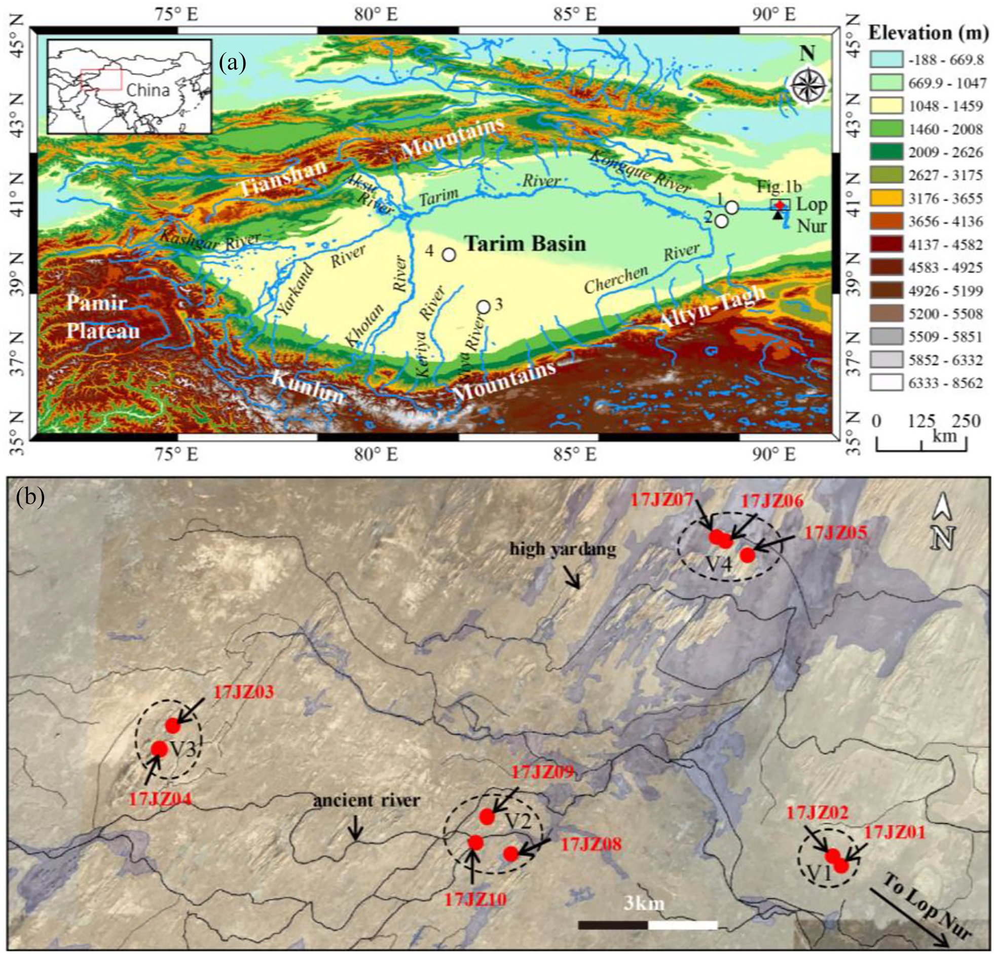
Location of the study area. (a) Map of the Tarim Basin. The red star indicates the NLS prehistoric settlements. (b) Blue lines are rivers (vector file downloaded from http://bbs.3s001.com); white circles are Xiaohe cultural sites; and the black triangle shows the location of the ancient city of Loulan (Li et al., 2019b). 1, Gumugou (Wang, 2014); 2, Xiaohe Cemetery (Xinjiang Institute of Archaeology, 2007); 3, North Niya (Tang et al., 2013; Yue and Yu, 1999); 4, Northern Cemetery (Mair and Cheng, 2013; Wang, 2017a); DEM map downloaded from http://srtm.csi.cgiar.org. (b) Distribution of prehistoric settlements in North Loulan. The red circles indicate residential sites (Figures 2–10), and V1-V4 indicate prehistoric villages. The black lines indicate former river channels, and the shaded area represents former wetland. The remote sensing map is from Google Earth.
The Lop Nur region (Figure 1), in the eastern Tarim Basin, was an important juncture between ancient China, Central Asia, and the Mongolian and Tibetan Plateaus. The region has a hyper-arid climate and associated yardang landforms, caused by its great distance from the ocean and the rain shadow effect of the surrounding high mountain ranges. Annual precipitation is approximately 20 mm, whereas potential evaporation exceeds 3000 mm; hence it is known as the core arid zone of Eurasia (Xia et al., 2007). The western bank of Lake Lop Nur has experienced an alternation of oasis and yardang-desert environments since the late Pleistocene, accompanied by varying levels of human activity (Li et al., 2018a, 2018b, 2019b). Landforms consisting of wind-eroded NE-SW-oriented yardang terrains, which vary greatly in morphology and chronology, are widespread on the western bank of Lake Lop Nur. The oldest yardangs are as high as 20 m or more in the northern part of the ancient city of Loulan, the sediments of which were deposited in the middle and late Pleistocene (Li et al., 2021; Wang et al., 2008). Smaller yardangs, with heights mainly below 2 m, are mainly composed of silty clay which was deposited in the Holocene (Lin et al., 2018; Qin et al., 2012).
The prehistoric Xiaohe Culture, in the extremely arid Lop Nur region, is known from the sites of Xiaohe Cemetery and Gumugou Cemetery (ca. 2nd millennium BC) (Wang, 2014; Xinjiang Institute of Archaeology, 2007; Yidilisi et al., 2019). The Gumugou Cemetery was excavated in 1979 and Xiaohe Cemetery was excavated in 2002 and 2003 (Wang, 2014; Xinjiang Institute of Archaeology, 2007). Radiocarbon assays of these cemeteries suggested that Gumugou was slightly older than Xiaohe (Xia et al., 2007). The characteristics of the subsistence strategy of the inhabitants were preliminarily revealed based on materials from Xiaohe burials. The stable isotopes of carbon and nitrogen in human bones and hair suggest that their diet included animal products (e.g. mutton and beef) and C3 plants (e.g. wheat), although there was an evolution of the diet over time (Qu et al., 2017; Zhang and Zhu, 2011), which is indicated by macroscopic-remains excavated from cemeteries (Yang et al., 2014a; Zhang et al., 2015). Organic residues (e.g. protein) suggest that milk products (cheese and sour milk) were popular in the region during the Bronze Age (Xie et al., 2016; Yang et al., 2014b).
The significance of the Xiaohe Culture for trans-continental cultural exchange from the early second millennium BC is indicated for example by stone mace heads and well-preserved wheat and common millet seeds in Xiaohe burials, which originate in the west and east (Flad et al., 2010; Xinjiang Institute of Archaeology, 2007; Yidilisi et al., 2019). In addition, the nature of the human-environment interactions of this desert-oasis civilization is evident from previous research (An, 1996; Betts et al., 2019). However, there is a long-running debate regarding the nature of the occupation and the demise of the Xiaohe Culture, since settlements were established in the region which have persisted for centuries and there are striking differences from cultures in the neighboring areas (Betts et al., 2019; Shao, 2018; Xiao, 2013). From this perspective, several specific questions need to be addressed: (1) what were the environmental conditions during the development of the Xiaohe Culture, and which were the most important for shaping the material culture? (Betts et al., 2019; Li et al., 2013; Yang, 2019; Zhang et al., 2015). (2) What was the cause of the demise of the Xiaohe population in the Lop Nur region? (Mair, 2014; Pavel et al., 2019; Tang et al., 2013). (3) Since a robust chronological framework is still unavailable, what was the temporal relationship between different Xiaohe cultural sites? (Flad et al., 2010; Mair, 2014; Yang, 2019; Yidilisi et al., 2019). At the heart of the debate is the lack of integrated evidence from the settlements of the Xiaohe Culture, which hinders our ability to address these questions.
The lack of relevant discoveries about the nature and pattern of human settlements of the Xiaohe Culture has hindered our understanding of the lives of the Bronze Age inhabitants of the Tarim Basin. In this study, we attempt to provide an improved understanding of the prehistoric Xiaohe Culture in the Tarim Basin and its interaction with geomorphic conditions, using comprehensive field investigations and chronological analyses based on the radiocarbon dating of the newly-discovered Xiaohe cultural sites (i.e. the North Loulan Settlement, NLS).
Description of the studied archaeological sites
Numerous distinctive Xiaohe dwelling places have been found within an area ca. 30 km north of the ancient city of Loulan (Figure 1) (NLS); several of the sites discussed here were discovered in 2009 (Li, 2014; Xinjiang Bureau of Relics, 2015; Yidilisi et al., 2019), and others are newly-discovered. The sites are described below.
Site 17JZ01: The site is located at the top of a high yardang (height: ~20 m, length: ~270 m) and is an easternmost site of North Loulan (Figure 2a). The top of the yardang contains a circular dwelling (Figure 2b), with a pit containing charcoal within the profile. Reed layers (Figure 2c), ~50-cm thick and buried by blocks of sediment on the slope of the yardang, may represent the remains of an ancient dwelling. Pieces of woven grass rope were also found in the mixed layers (Figure 2d). A former river channel is located 25 m to the west of the yardang, containing the remains of reeds and a thin salt crust.
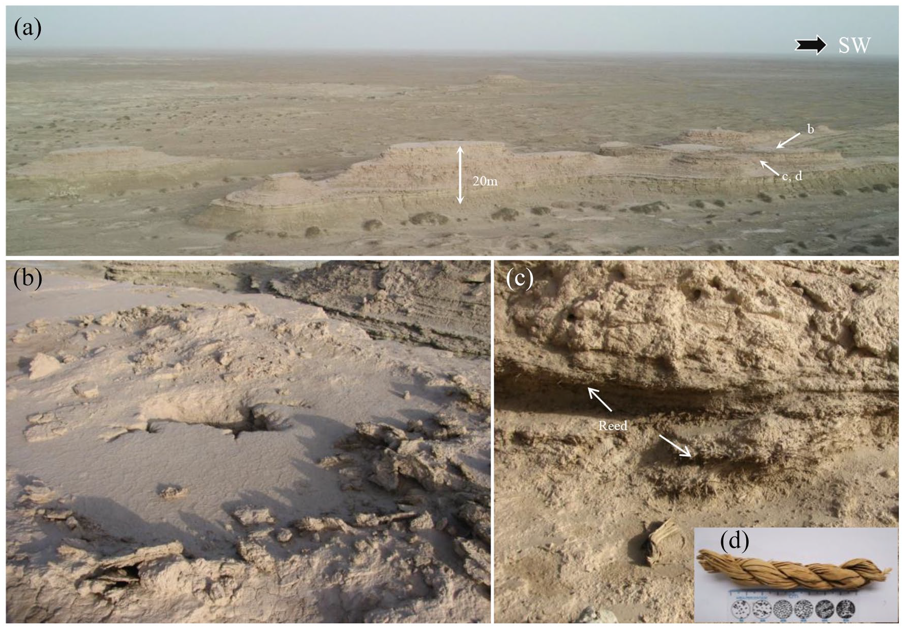
Photograph of site 17JZ01. The site has also been coded as 09LE49 (Xinjiang Bureau of Relics, 2015). (a) Geomorphic features. (b) Remains of a circular dwelling. (c) Buried reed layers corresponding to samples 17L34 and 17L35. (d) Woven grass rope (17L36).
Site 17JZ02: This residential site is located at the top of a yardang platform (height: ~20 m, length: ~80 m) (Figure 3a). Dwellings are represented by circular remains; no in situ relics were found on the surface (Figure 3b). A severely damaged cemetery (site 17JZ02-M01) was investigated at the top of the neighboring yardang. Mummified human remains (Figure 3f), a woven grass basket and rope (Figure 3c and e), coffins, and reeds were scattered on the surface, as well as red fabric and animal hairs. In front of a coffin there were notched columns (Figure 3d) which are similar to those of Xiaohe Cemetery (Xinjiang Bureau of Relics, 2015). Pieces of worked wood with an oblate-shaped end were also found at the site. The site is close to former river channels, located 30 m to the north and 25 m to the west, and there are well-developed salt crusts.

Photograph of site 17JZ02. The site has also been coded as 09LE50 (Xinjiang Bureau of Relics, 2015; Yidilisi et al., 2019). (a) Geomorphic features. (b) Remains of circular dwellings. (c) Woven grass basket. (d) Columns with cut-marks. (e) Woven grass rope corresponding to sample 17L31. (f) Mummified human remains.
Site 17JZ03: This site is located at the top of a yardang platform (height: 25 m, length: 120 m, width: 45 m) (Figure 4a) in the vicinity of several former river channels. Mixed layers of animal feces (e.g. sheep, cattle, and camel feces) and reeds occur on the west and east collapsed slopes of the yardang. On the south side, charred bones, stone spear heads, and a quartz core were collected from hearths (Figure 4a). On the north side, ash layers and a semi-subterranean dwelling with circular polished walls were present (Figure 4b, diameter: 3 m, depth: 60 cm). Charcoal fragments were found within a sandy layer within the yardang strata. Painted pottery shards (Figure 4c), sheep horns, a millstone, and arrowheads were collected from the site. Li (2014) concluded that the types of pottery shards collected from the site attest to the occurrence of a diverse culture.

Photograph of site 17JZ03. The site has also been coded as 09LE3 (Xinjiang Bureau of Relics, 2015). (a) Geomorphic features (the car is for scale). Sample 17L41 (sheep feces) is from the reed and feces layer. (b) A circular semi-subterranean dwelling. The charcoal within the dwelling corresponds to sample 17L42. (c) Painted pottery shard.
Site 17JZ04: This residential site is located at the top of a yardang (height: 20 m, length: 90 m, Figure 5a), ~900 m south of site 17JZ03. A salt crust and former river channels occur nearby. A row of collapsed and buried dwellings, which are indicated by reeds (Figure 5b), woven grass mats, and ropes (Figure 5d), together with Bovidae teeth excavated from an ash pit, were discovered on the east side of the yardang platform. This suggests that the excavation of semi-cave structures depended on the morphology of the yardang. Painted pottery shards and a jade axe were found on the surface of the site (Figure 5c).

Photograph of site 17JZ04. (a) Geomorphic features. The remote sensing map is from Google Earth. (b) Collapsed dwelling. Sample 17L46 (sheep feces) is from the reed and feces layers. (c) Pottery shards and a jade axe. (d) Woven grass rope corresponding to sample 17L45.
Site 17JZ05: This site is located on a high yardang (height: 30 m, length: 350 m, width: 50 m) (Figure 6a) to the southwest of Tuyin Site (Li et al., 2019b) and in the vicinity of a former wetland and river channels. Mounds consisting of blocks of the remnants of the yardang platform were found. A former dwelling (17JZ05-1) is indicated by two layers of reeds that were emplaced on top of thick mudstone platforms (thickness: ~1 m) on the yardang slope (Figure 6a and b). The reed layers may represent a mixture of roof and ground surface material, because the latter are often mixed with charcoal and camel/sheep feces. Worked animal horn and wood, fabric, and hair were collected from the upper reed layer (Figure 6c). The lower reed layer (~1 m) contains woven grass rope and tamarisk fragments. Fragments of stone artifacts (e.g. a spear head) (Figure 6a), and a copper needle, were discovered at the site. Another dwelling is located at the north end of the yardang, which is indicated by reed layers and animal excrement. Stone tools (e.g. a spear head) (Figure 6a), were discovered within. A tomb (17JZ05-M01), very badly damaged, is located at the south end of the yardang. Mummified human bodies and a woven grass basket were also discovered (Figure 6d). In front of a coffin, there were pillars, partly painted red, that are similar to those of Xiaohe Cemetery (Xinjiang Institute of Archaeology, 2007). The elevation of the terrain in the vicinity of the tomb is higher than the dwellings.
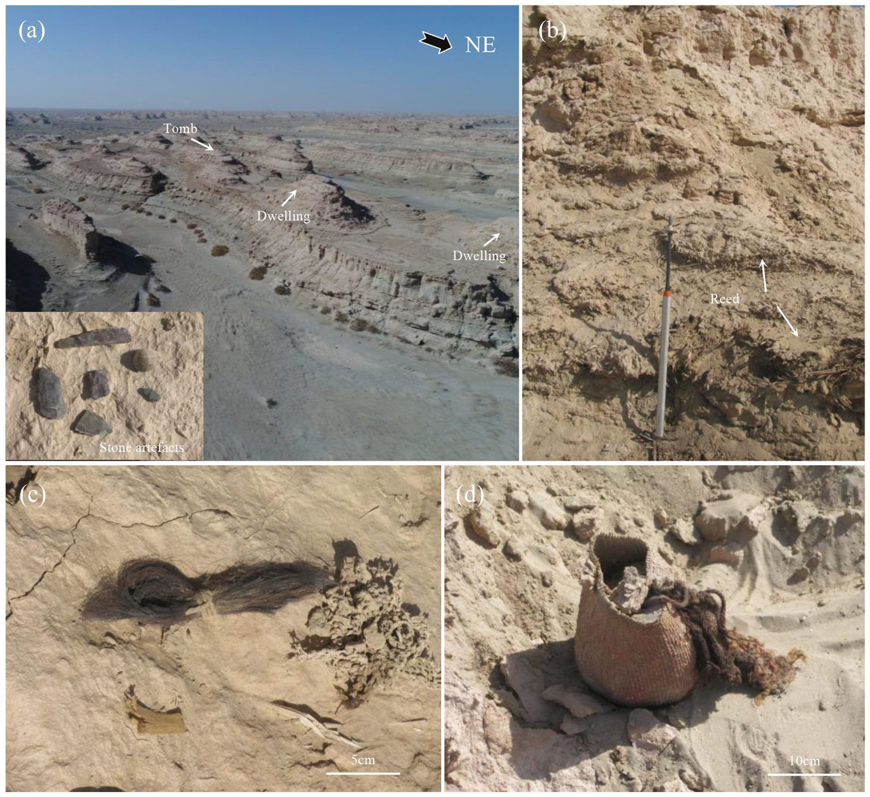
Photograph of site 17JZ05. (a) Geomorphic features and stone tools. (b) Collapsed ancient dwellings (reed sample: 17L71). (c) Hairs and textile fragments corresponding to samples 17L78 and 17L79, respectively. (d) Woven grass basket from site 17JZ05-M01 was found and a sheep feces sample was collected from the tomb for dating (17L80).
Sites 17JZ06 and 17JZ07: These sites are located at the top of yardangs located 440 and 620 m to the west of site 17JZ05, respectively (Figure 7), in the vicinity of large areas of former wetland and river channels. Ancient dwellings, now collapsed but indicated by reed layers, were built on the slope of the yardang. Tombs were discovered on the tops of neighboring yardangs.
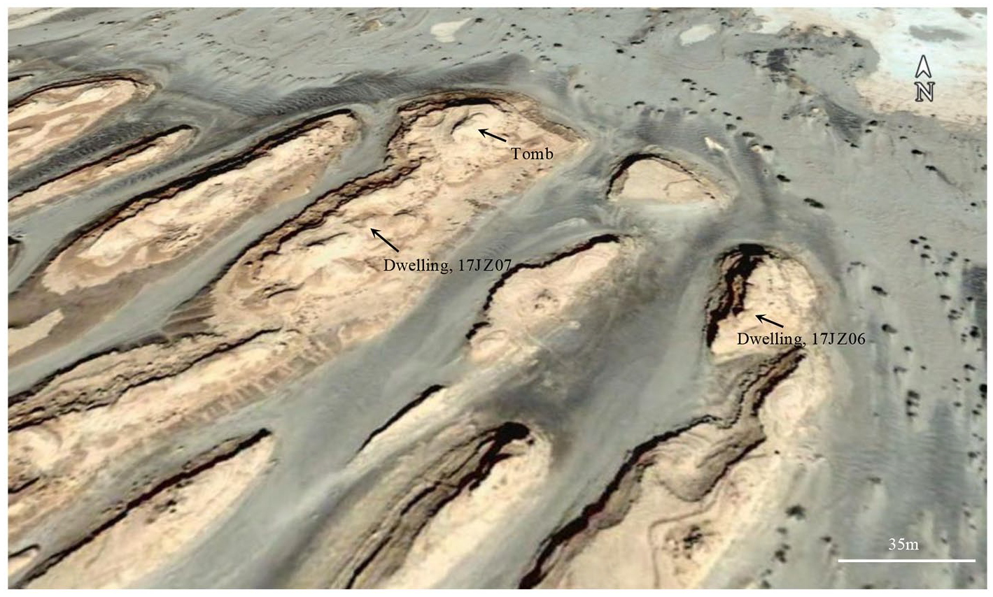
Geomorphic features of sites 17JZ06 and 17JZ07. Two reed samples were collected from the sites for dating (17L97 and17L98). Remote sensing map is from Google Earth.
Site 17JZ08: This residential site is located at the top of a yardang (height: 20 m, length: 70 m), 7.2 km to the west of site 17JZ02 (Figure 8a). Former river channels, flowing eastward, were discovered ca. 500 m north of the site. A salt crust is developed in the vicinity of the site. A collapsed dwelling, indicated by a 40-cm-thick mixed layer of reeds, ash, and animal feces (Figure 8c and d), is buried beneath yardang blocks. A stone pestle was discovered beneath the reed layer. The site contains a large area of ashes associated with red-colored burnt soil. Stone arrowheads and pottery shards with a black agglomeration were collected (Figure 8e). A 10-cm-thick layer of grass mixed with mud is present at the site. Animal horns and feces, fish bones (Figure 8b), and pottery were also discovered at the site.
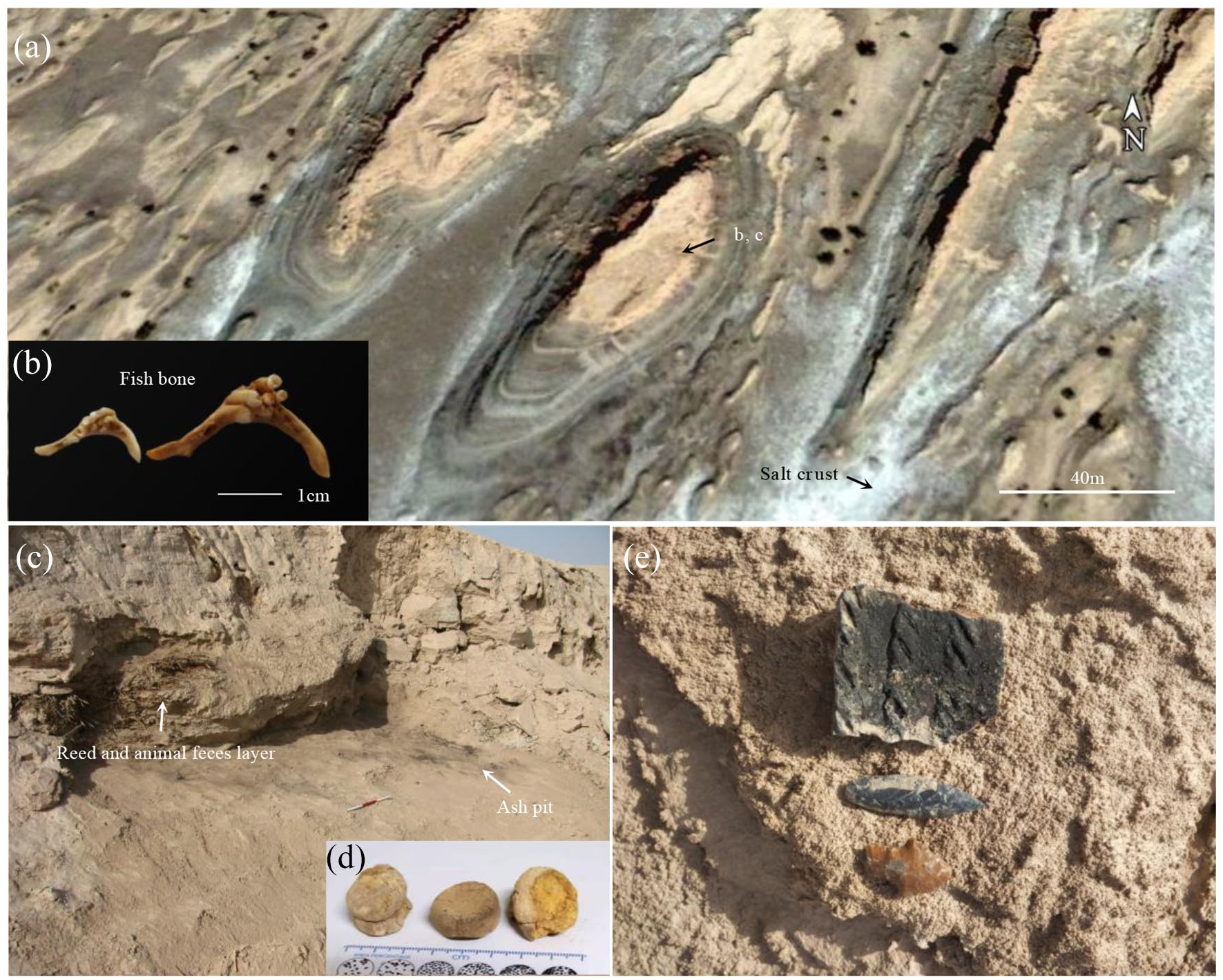
Photograph of site 17JZ08 (also coded 09LE2 (Xinjiang Bureau of Relics, 2015)). (a) Geomorphic features. Remote sensing map is from Google Earth. (b) Pharyngeal teeth of Cyprinidae. (c) Collapsed ancient dwelling. (d) Camel feces corresponding to sample 17L101. (e) Pottery shards and stone arrowheads.
Site 17JZ09: This residential site is located on a yardang platform (Figure 9a), 600 m to the west of site 17JZ02. The height of the yardang is ~26 m and the length is ~70 m. A former river channel is located 30 m west of the site. Ancient dwellings (Figure 9b), indicated by reeds, are buried by collapsed yardang blocks, from which woven grass ropes, ashes, fish and other animal bones, and animal feces have been investigated. Wooden tools and plant seeds were collected from a cave which was excavated within the loose sandy layer of the yardang (Figure 9c and d). In addition, a jade axe and three-edged stone artifacts with rounded ends and cut-marks were collected from the surface.
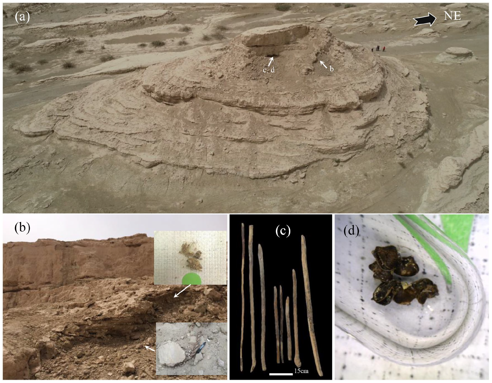
Photograph of site 17JZ09. (a) Geomorphic features (person for scale). (b) Ancient dwelling. The woven grass rope and sheep feces correspond to samples 17L84 and 17L87, respectively. (c) Wooden artifacts with cut-marks corresponding to samples 17L100-1 and 17L100-2. (d) Seeds of Scirpus corresponding to sample 17L105.
Site 17JZ10: This residential site is located at the top of a yardang (height: 15 m, length: 40 m, Figure 10a), 500 m to the south of site 17JZ09. A thin salt crust with the remains of tamarisk and other salt-tolerant plants is present. Former river channels, flowing eastwards and southwards, were found 130 m to the north and 50 m to the west of the site, respectively. The roof is completely collapsed due to strong wind erosion, and the ancient dwelling was subsequently buried beneath yardang blocks (Figure 10b). A thick ash layer mixed with animal excrement was identified beneath the reed layer (Figure 10b). In addition, we discovered a woven straw door curtain (Figure 10c) and reed arrow shafts.

Photograph of site 17JZ10. (a) Geomorphic features. (b) Site covered by collapsed yardang blocks. Camel feces and a woven grass rope corresponding to samples 17L103 and 17L104, respectively. (c) Fragment of a woven grass curtain.
Methods
In recent years, comprehensive field investigations have been conducted by geologists, palaeoecologists, archaeologists, and anthropologists in order to characterize in detail the prehistoric remains in the Lop Nur region. Because of the lack of roads and freshwater in the Lop Nur region, prior to field investigations we conducted a systematic interpretation of geomorphological characteristics and potential ancient sites using Google Earth.
A synthesis of reliable age determinations is crucial for providing a robust chronological framework for the evolution of the Xiaohe Culture. The dateable materials collected from the NLS site included herbaceous plant remains, animal feces and hair, and fabric, all of which are clearly indicative of human activities (Figures 2–10; Table 1). Twenty-two samples were selected for accelerator mass spectrum (AMS) radiocarbon dating, which was conducted by Beta Analytic Inc., USA. The pretreatment procedures for the various materials were similar and consisted of the following steps.
Radiocarbon dates for the NLS.
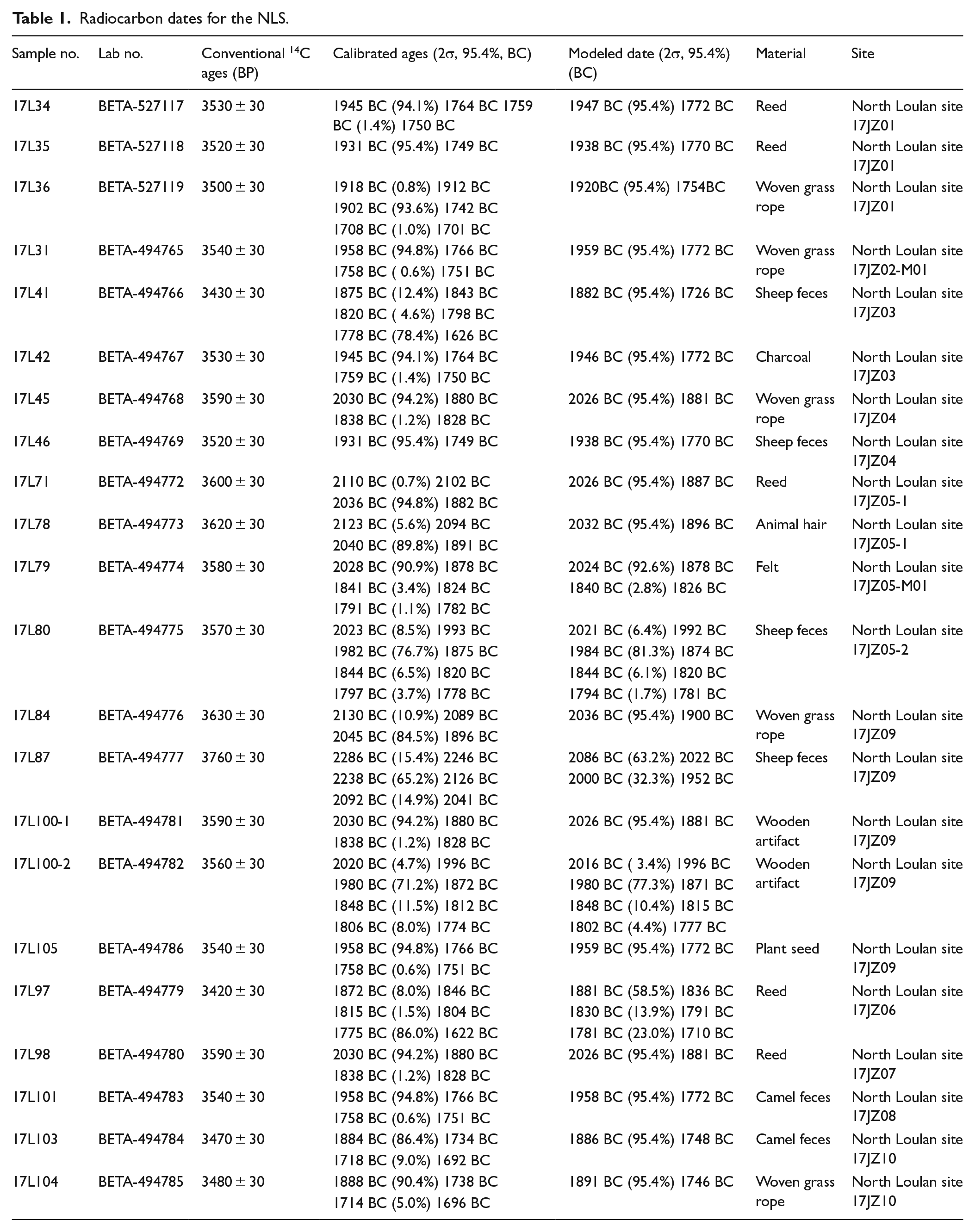
Each sample was reduced to 1–2 mm particles by dissection and crushing and was then rinsed in deionized water at 70°C. Samples were pretreated using the AAA (acid-alkali-acid) method, after which they were rinsed to neutral and oven-dried at 100°C for 24 h. Each sample was then placed in a combustion vessel to which 100% O2 was added and the sample was then combusted to produce CO2. The CO2 was then introduced into a reaction vessel containing an aliquot of a metal catalyst. H2 was introduced and the mixture was heated to 500°C to isolate the carbon as graphite, and the graphite was then pressed into a target for AMS measurements. Conventional radiocarbon ages were calculated using the Libby half-life (5568 yr) and corrected for isotopic fractionation. We screened the available conventional 14C dates of the Xiaohe Culture from previous publications, according to the following criteria: (1) The radiocarbon ages were based on the Libby half-life; (2) dates that were not accepted or deemed ambiguous in the original publication were rejected. Finally, the new and collected dates were calibrated and modeled within a Bayesian framework using the IntCal20 dataset (Reimer et al., 2020) with the OxCal v4.4.2 program (Bronk Ramsey, 2009, 2017). The calibrated and Bayesian-modeled 2σ ranges of the dates from the NLS are listed in Table 1 and illustrated in Figure 11 (for further details, see the Supplemental materials).
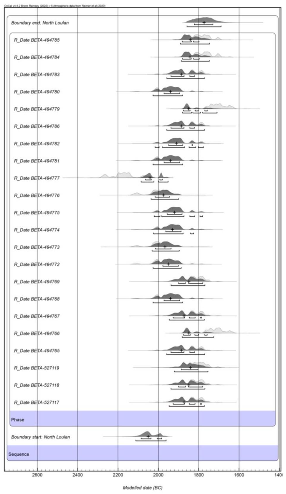
Probability distribution of dates from the NLS.
Results
The NLS is characterized by high, wind-eroded yardang landforms. The spatial distribution of settlements features four relatively concentrated zones (V1-V4), whose locations evidently depended on the high yardang landforms (Figure 1b). Thus it is clear that the high yardang platforms were important occupation and activity areas for the Xiaohe population, and a single yardang may correspond to an individual household. The distribution suggests four prehistoric villages (V1–V4) separated by distances of 7–14 km, with several former river channels in their vicinity. Beyond the areas with yardangs, there is evidence of a former wetland with salt-tolerant and drought-tolerant vegetation.
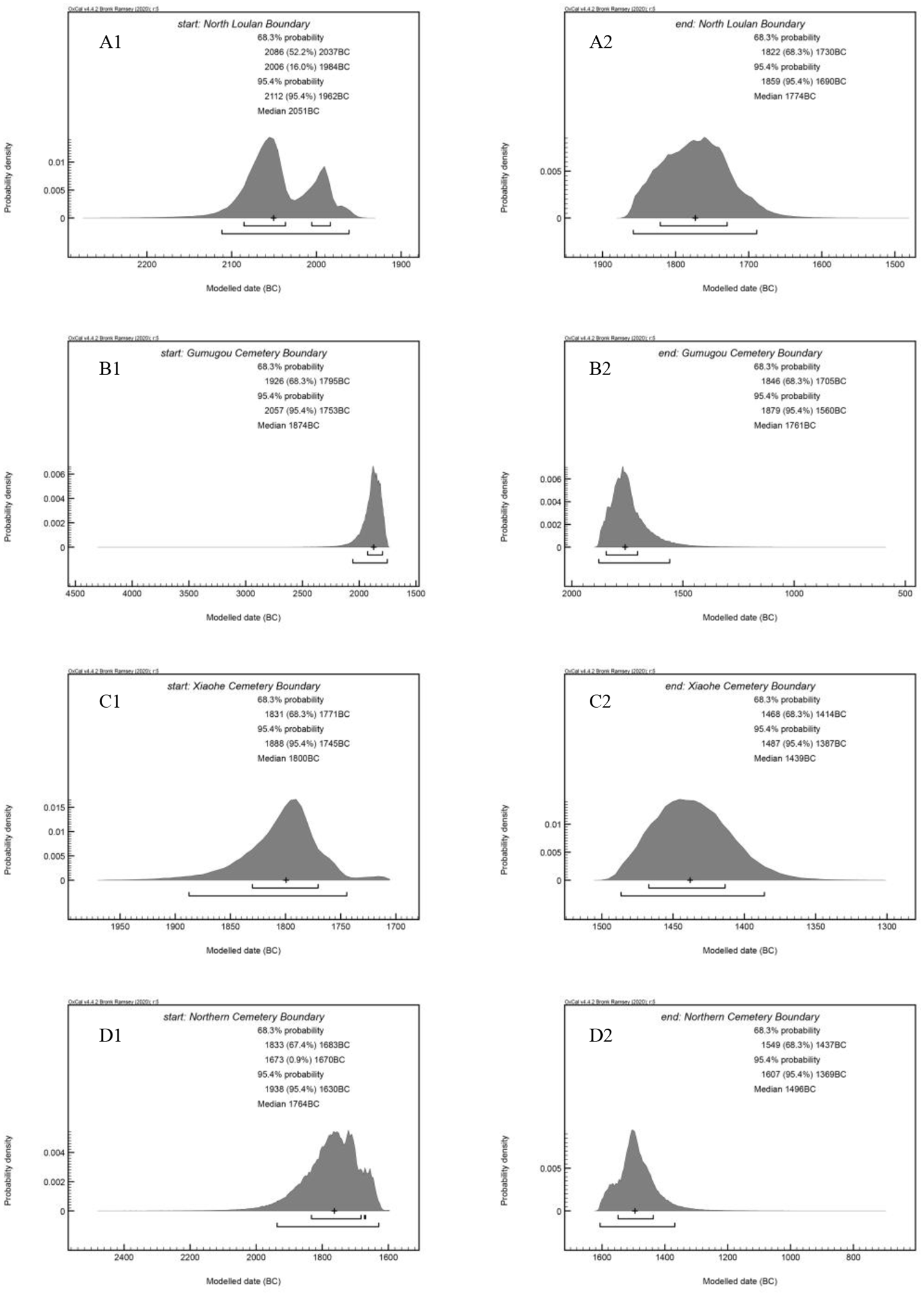
The modeled age for the start and end of human occupation of the NLS is ca. 2112–1962 BC (95.4% probability, median: 2051 BC) and ca. 1859–1690 BC (95.4% probability, median: 1774 BC) (Figure 11). Based on the 95% probability range, the durations of settlements V1–V4 have the respective ranges of 2036–1777 BC (median: 1881 BC) to 1896–1642 BC (median: 1788 BC); 2336–2031 BC (median: 2117 BC) to 1875–1606 BC (median: 1766 BC); 2255–1783 BC (median: 1955 BC) to 1884–1436 BC (median: 1751 BC); and 2147–1908 BC (median: 1998 BC) to 1886–1598 BC (median: 1829 BC). The age of residential sites from which we collected painted pottery shards was up to ca. 2000 BC.
Discussion
Palaeo-landscape around the settlement and sedentary subsistence strategy
Records of macrofossils (plant remains and seeds) and microfossils (pollen and phytoliths) from Gumugou Cemetery and Xiaohe Cemetery have recently been reported (Li et al., 2013; Pavel et al., 2019; Qiu et al., 2014; Xie et al., 2013; Zhang et al., 2015). The results suggest that the local vegetation consisted mainly of Populus, reeds, Gramineae, Chenopodiaceae, Artemisia, and Ephedra, which are typical of a desert oasis environment. In addition, the abundance of animal remains (e.g. cattle, sheep) in Xiaohe burials suggests that the vegetation and water resources were sufficient for a sustainable existence (Mair, 2012; Wang, 2014; Yidilisi et al., 2019). A sedimentary profile near Xiaohe Cemetery indicates that there was a water body in the vicinity, and hence a favorable hydrological environment existed during ca. 2800–1500 BC (Zhang et al., 2017).
The NLS site is located in the terminal area of the Kongque River (a tributary of the ancient Tarim River) and is characterized by ~20-m-high yardangs which developed in the middle to late Pleistocene (Li et al., 2021; Wang et al., 2008). The bones of Cyprinidae (Figure 8b) and seeds of Scirpus (Figure 9d), both of which have disappeared from the Lop Nur region (Xia et al., 2007), suggest the occurrence of freshwater bodies around the NLS which dates to the early Bronze Age. However, plant remains recovered at the NLS are mainly herbaceous plants (e.g. reed plants) and wood and timber are rare, except for coffins and tamarisk sticks. This implies that humans selectively utilized trees and shrubs at that time because of the lack of metal tools, or alternatively because of the scarcity of woody plants. Therefore, the landscape of NLS was dominated by extensive island-like yardangs within a lake or wetland fed by now-desiccated rivers.
The dwellings were built on the top or on the secondary platform of high yardangs (Figures 2–10). There are multiple platforms on yardangs and collapsed clay blocks imply that the living space at that time was much more extensive than is indicated by the platforms surviving today. The dwellings on the top platform of high yardangs have distinct semi-subterranean circular features (Figures 2–4) and charcoal layers are preserved within some of the circular dwellings. Another type of dwelling was built along the cliff on the secondary platform, composed of a wind-erosion-resisted clay formation (Figures 5 and 6). The latter type of dwelling corresponds to the sandy layers of yardang formations and is similar to a half cave, probably because the loose sand layer can be easily excavated. In the lower platform of high yardangs, thick mixed accumulation layers of reeds and camel and sheep dung are often found, suggesting that livestock were kept on the lower platform of the yardang. Therefore, the main mode of subsistence of the inhabitants was to raise livestock on the lower platform and to inhabit the upper platform of high yardangs. This type of settlement may have provided protection from floods and predators.
The NLS sites characterized by their careful placement and a close proximity to each other, suggest a high level of social interaction. The relationship between human interaction and the landscape helps us to better understand the lifestyles of the inhabitants and their adaptation of construction methods to the inhospitable terrain.
Population migration associated with the Xiaohe Culture
Based on their material culture, craniometrics, and genetic results it has been suggested that the Xiaohe people may originate in the Eurasian steppe (Han, 1998; Kuzmina, 1998; Li et al., 2010, 2015; Mallory and Mair, 2000; Nie et al., 2020; Shao, 2018; Yang, 2019). Others have argued that they originated in an oasis area in Central Asia, based on the environmental similarity (Barber, 1999; Chen and Hiebert, 1995; Hemphill and Mallory, 2004; Li et al., 2015), though the hypothesis is speculative; and Wang (2017b) suggested that the Xiaohe cultural remains may be related to those from the Caucasus region. However, the abovementioned hypothesizes lack robust material and chronological evidence and the potential routeways of migration are unknown.
The Xiaohe population in the Lop Nur region is represented by the NLS, Tiebanhe Cemetery (Xia et al., 2007), Gumugou Cemetery (Wang, 1983; Xia et al., 2007), and Xiaohe Cemetery (Flad et al., 2010; Pavel et al., 2019; Qiu et al., 2014; Yang et al., 2014a; Yidilisi et al., 2019). The North Bank of Lop Nur and Tiebanhe Cemetery are assigned to the NLS based on location descriptions in the original publications (Li, 2014; Xia et al., 2007; Yidilisi et al., 2019). The NLS and Gumugou Cemetery (100 km to the west of the NLS) are located on the terminal and middle-lower reaches of the Kongque River, which was a tributary of Tarim River. Bayesian modeling applied to a compilation of published and newly-obtained 14C dates directly derived from the abovementioned sites (see the Supplemental Table) suggests that the Xiaohe Culture falls within the age range of 2077–1403 BC, and that the NLS represents the earliest known occupation of the Xiaohe population in the Tarim Basin.
The earliest human occupation of the NLS and Gumugou Cemetery is dated to 2112–1962 BC (95.4% probability, median: 2051 BC) and 2057–1753 BC (95.4% probability, median: 1874 BC), respectively (Figure 12); thus, the beginning of human occupation of the former occurred several centuries earlier than that of the latter. However, the ending of human activity at NLS (median: 1774 BC) was roughly equivalent to that of Gumugou Cemetery (median: 1761 BC). Notably, the earliest occupation of Xiaohe Cemetery, located ~45 km southwest of Gumugou Cemetery, is dated to 1888–1745 BC (95.4% probability, median: 1800 BC), with abandonment dated to 1487–1387 BC (95.4% probability, median: 1439 BC) (Figure 12). The modeled dates clearly show a chronological sequence among these Xiaohe cultural sites in the Lop Nur region. In addition, there is a developing process of burial practices from Gumugou Cemetery to Xiaohe Cemetery (Yang, 2019). These evidences imply that the inhabitants of Xiaohe Cemetery migrated in groups to and from the site, most likely from Gumugou and the NLS area.
Modeled age ranges of Xiaohe cultural sites.
The modeled radiocarbon ages from the Northern Cemetery site, located ca. 580 km west of Xiaohe Cemetery and characterized by a typical Xiaohe Culture (Mair, 2014; Mair and Cheng, 2013; Wang, 2017a), suggest that the beginning of human occupation occurred within the range of 1938–1630 BC (95.4% probability, median: 1764 BC) (Figure 12), which is almost equivalent to the age of cessation of human activity at Gumugou Cemetery. The material culture in the Northern Cemetery was slightly more developed than that of other Xiaohe burials (Mair and Cheng, 2013; Wang, 2017a). The cessation of human activity at the Northern Cemetery occurred during 1607–1369 BC (95.4% probability, median: 1496 BC) which is slightly earlier than at Xiaohe Cemetery (Figure 12).
According to the modeled ages for these sites, it is possible to construct a chronological series (Figure 13), which clearly indicates that the easternmost NLS was the first settlement of the Xiaohe population in the Tarim Basin (Figure 13). It is also clear that there was westward migration within the Lop Nur region and on basin scale (i.e. from the eastern to the central Tarim Basin) (Figure 14).
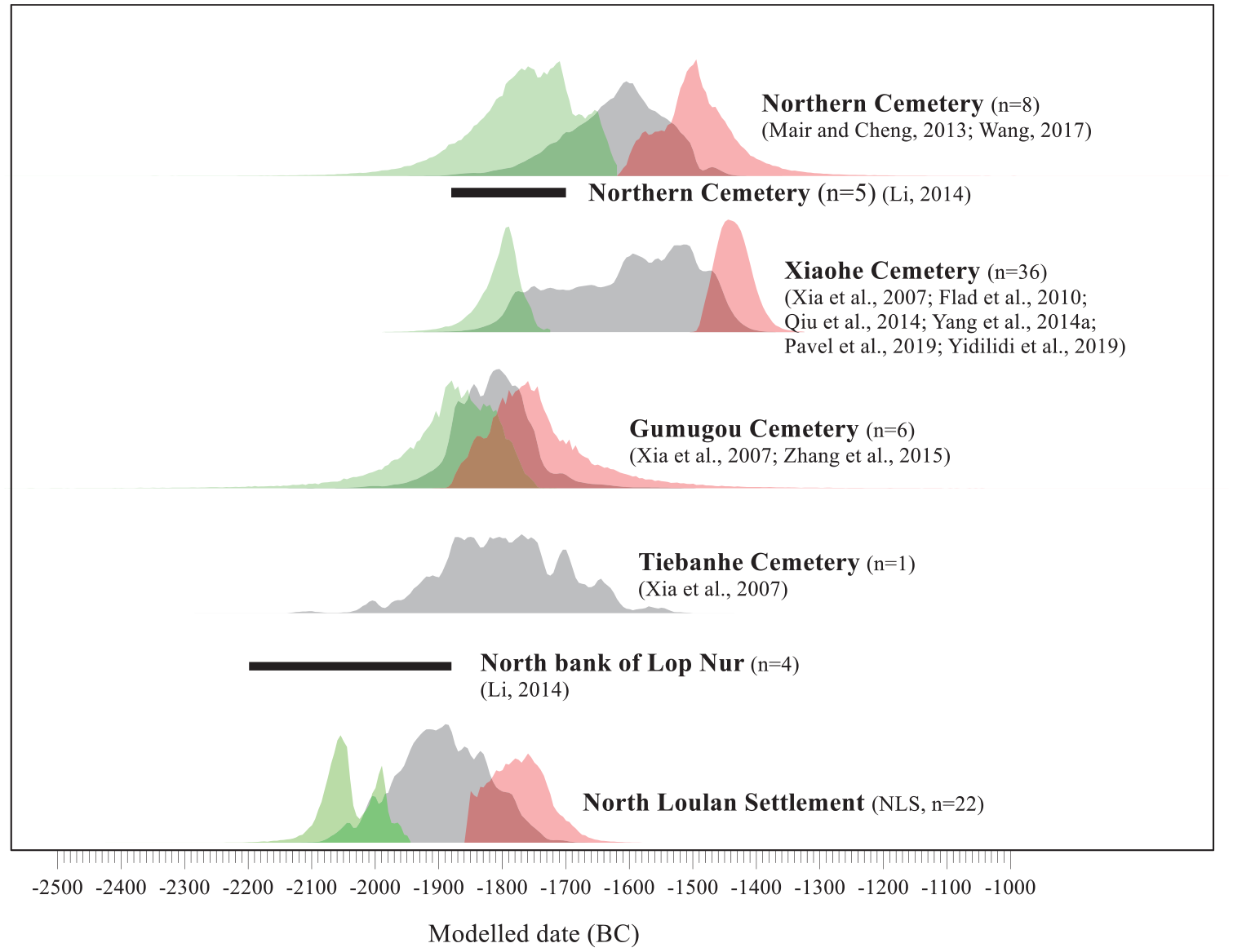
Modeled probability distribution (posterior) with a start (green) and end (red) boundary of Xiaohe cultural sites. The summed radiocarbon probability distribution (gray) was determined using OxCal v4.4.2 (Bronk Ramsey, 2009, 2017) and the IntCal20 dataset (Reimer et al., 2020). The data were then normalized. The black bars show the age of radiocarbon dating without any detailed information in original publication (Li, 2014). Further information about the ages is given in the Supplemental Table.
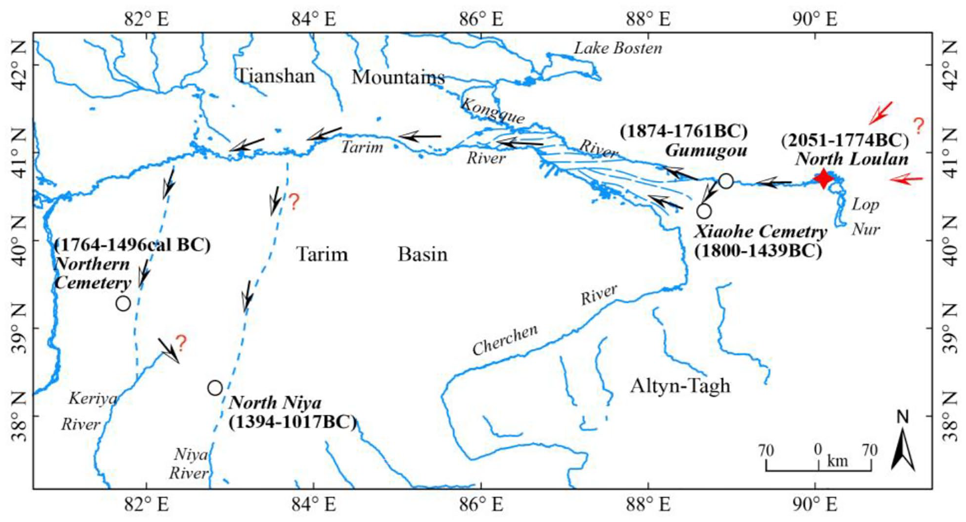
Potential westward migration route of the Xiaohe Culture.
This migration helps to clarify the intermittent nature of the development of the society that once occupied the west bank of Lake Lop Nur. The characteristics of human skulls from the ancient Loulan cemeteries in the Han-Jin period (202 BC–AD 420) differ from those of Xiaohe cultural burials (Han, 1986; Nie et al., 2020; Wei et al., 2020), indicating that the population during two cultural stages in the Lop Nur region did not have the same origin. However, it is unclear which factors were responsible for the long-distance migration of the Xiaohe people: that is, whether it was driven by environmental processes, such as a decrease in runoff leading to environmental degradation, which may have initially occurred at NLS, located at the terminus of the Kongque River, and subsequently occurred at Gumugou; or whether it was primarily caused by societal factors. This question can only be addressed by future multidisciplinary research, including in the fields of archaeology, palaeoecology, and palaeoclimatology.
Bronze Age cultural interactions in the central and eastern Tarim Basin
Eurasian immigrants encountered immigrants to Gansu at Hami, in the eastern Tianshan Mountains, as documented by research on the Tianshanbeilu Culture (Gao et al., 2015; Li et al., 2015; Wang et al., 2019; Wei, 2017). Thus it is almost inevitable that influences from Gansu were incorporated in the Xiaohe Culture in the Lop Nur region, as is already documented by the occurrence of millet and wheat grains at Xiaohe Cemetery (Yang et al., 2014a).
The Xiaohe Culture has been regarded as an aceramic culture (Betts et al., 2019), because Gumugou and Xiaohe Cemeteries are characterized by wooden and woven grass artifacts (Li, 2014; Wang, 2014; Xinjiang Institute of Archaeology, 2007). However, an increasing quantity and diversity of pottery shards have been reported (Huang, 1948; Li, 2014), indicating that elements of the Xiaohe Culture were more diverse than previously thought. Furthermore, although the timing and routeway of the westward spread of painted pottery have been previously discussed (Han, 2018; Lin, 2020; Shao, 2018), the Lop Nur region has been ignored because of the scarcity of material evidence and the lack of referenced absolute dating. The earliest age of the painted pottery shards found in the NLS (Figures 4 and 5) is ca. 2000 BC, which is constrained by radiocarbon dates from charcoal (17L42), woven grass rope (17L45), and sheep feces (17L46) surrounding the pottery on the yardangs, indicating that oriental cultural elements had spread to the Lop Nur region by that time. Based on the limited observations possible from the painted pottery shards of the NLS, some of it may be affiliated to those of eastern Xinjiang, such as Tianshanbeilu Cemetery which is broadly contemporary with the NLS (Tong et al., 2020; Wang et al., 2019). Furthermore, the settlers of the NLS were characterized by the populations from eastern Eurasia, based on the physical anthropological characteristics of skulls (e.g. brownish hair and a relatively high degree of facial flatness) (Figure 3f); these observations are similar to those made of skulls and genetic characteristics of the early stage of Xiaohe Cemetery (Li et al., 2015; Nie et al., 2020).
Thus, the currently available data strongly suggest that the earliest settlers of the Xiaohe Culture may have migrated into the eastern Tarim Basin along the eastern or northeastern corridors (Figure 14) and that they interacted with oriental culture. Later, during the centuries when the Xiaohe Culture thrived, the population constantly blended with other cultures, resulting in complex multi-ethic characteristics that were recorded by the diverse genetic components in the human remains from Xiaohe Cemetery (Li et al., 2010, 2015).
Conclusions
The prehistoric Xiaohe Culture in the Lop Nur region is quite different from any of the contemporary cultures within the surrounding region, which makes it especially important for the study of prehistoric civilization in the drylands of the Asian interior. This study presents the first systematic archaeological and radiocarbon dates from the newly-discovered settlements.
The radiocarbon dates for the NLS are within the range of ca. 2051–1774 BC and the Xiaohe Culture falls within the range of ca. 2077–1403 BC, based on a synthesis of all of the reliable dates using a Bayesian model. Our field investigations reveal that the Xiaohe Culture was characterized by semi-subterranean or semi-cave dwellings that were built on the upper part of high yardangs within a lake or wetland environment, demonstrating that they were able to successfully occupy this inhospitable terrain. The new chronological and archaeological evidence clearly indicates that the northwest bank of Lake Lop Nur was the first settlement of the Xiaohe population, which was influenced by oriental culture, and suggests that the earliest settlers arrived in the Tarim Basin along potential eastern or northeastern corridors rather than the western routeway. Later, there was the westward migration of peoples along the ancient Tarim River.
With regard to the cause of the migration of the Xiaohe populations, the available evidence suggests that their subsistence strategies depended on the environmental conditions; however, it is unclear whether the demise of their settlements was caused mainly by changes in available water resources. This question needs to be addressed by future multidisciplinary research, including the fields of palaeoecology, palaeoclimatology, and archaeology.
Supplemental Material
sj-docx-1-hol-10.1177_09596836211025968 – Supplemental material for New radiocarbon dating and archaeological evidence reveal the westward migration of prehistoric humans in the drylands of the Asian interior
Supplemental material, sj-docx-1-hol-10.1177_09596836211025968 for New radiocarbon dating and archaeological evidence reveal the westward migration of prehistoric humans in the drylands of the Asian interior by Kangkang Li, Xiaoguang Qin, Bing Xu, Yong Wu, Guijin Mu, Dong Wei, Xiaohong Tian, Huiqiu Shao, Chunxue Wang, Hongjuan Jia, Wen Li, Haoze Song, Jiaqi Liu and Yingxin Jiao in The Holocene
Supplemental Material
sj-xlsx-2-hol-10.1177_09596836211025968 – Supplemental material for New radiocarbon dating and archaeological evidence reveal the westward migration of prehistoric humans in the drylands of the Asian interior
Supplemental material, sj-xlsx-2-hol-10.1177_09596836211025968 for New radiocarbon dating and archaeological evidence reveal the westward migration of prehistoric humans in the drylands of the Asian interior by Kangkang Li, Xiaoguang Qin, Bing Xu, Yong Wu, Guijin Mu, Dong Wei, Xiaohong Tian, Huiqiu Shao, Chunxue Wang, Hongjuan Jia, Wen Li, Haoze Song, Jiaqi Liu and Yingxin Jiao in The Holocene
Footnotes
Acknowledgements
We thank the editor and reviewers for their helpful comments. Thanks are due to Prof. Gao Xing for discussion and advice on wooden artifacts, Prof. Li Zhipeng for identification of animal remains, and Dr. Wang Can for the calibration of the radiocarbon dates. We are also grateful to Prof. Wang Binghua and Dr. Gill Plunkett for suggestions and comments on earlier versions of the manuscript. We also thank Cui Yousheng, Ren Hui, and Zhang Ao for help during the field investigations and for providing photographs; Dr. Tang Zihua and Wang Xueye for providing references and editing the figure, respectively; Dr. Deng Zhenhua and Dr. Jan Bloemendal for the identification of plant seeds and for editing the English language, respectively.
Funding
The author(s) disclosed receipt of the following financial support for the research, authorship, and/or publication of this article: This work was financially supported by the Strategic Priority Research Program of the Chinese Academy of Sciences (XDB26020301), the National Natural Science Foundation of China (42072215, 41772182) and the Ministry of Science and Technology, China (2014FY210500).

Data and materials availability
All data generated or processed during this study are included in this published article (and its Supplemental material files).
Supplemental material
Supplemental material for this article is available online.
References
Supplementary Material
Please find the following supplemental material available below.
For Open Access articles published under a Creative Commons License, all supplemental material carries the same license as the article it is associated with.
For non-Open Access articles published, all supplemental material carries a non-exclusive license, and permission requests for re-use of supplemental material or any part of supplemental material shall be sent directly to the copyright owner as specified in the copyright notice associated with the article.
