
Abstract
NW Iberia is dominated by Atlantic climate areas that favour pollen preservation, useful for palaeoecological studies. However, the region also includes Mediterranean sectors in which preservation of such palaeoenvironmental evidence is more difficult. To overcome these constraints, archaeological plant macroremains can be used to help characterize flora and vegetation dynamics at a local and regional level. To fill the gap in knowledge in an understudied Mediterranean region, a large archaeobotanical study was conducted at the river Sabor valley, NE Portugal. With 13 archaeological sites sampled for charcoal, fruits and seeds, it allowed the study of vegetation throughout the Holocene, starting in the Mesolithic up to Modern times, with some chronological gaps. Tree taxa dominates the older period and an expansion of shrubby taxa since Bronze age was observed. Diversification of plants used during the Iron Age and Roman period suggests an intensification of resources exploitation and deforestation. These trends seem to be related with changes in human settlements and productive strategies. During Prehistory, agricultural fields were established in flat and wide areas, and, during Iron Age, fortified granaries were used to store large amounts of grains, particularly free-threshing wheat. Drastic changes in settlement during Roman times and the establishment of small farms producing wine and/or olive oil were testified by the occurrence of Olea and Vitis in both anthracological and carpological datasets. Data from more recent periods is scarce. Results highlight that the combination of several proxies and integration of archaeological evidence helps to understand ecological dynamics in areas without pollen data and contributes to the characterization of heterogeneous areas under diverse climatic conditions and with a variety of social trends.
Introduction
Palynological data and archaeological plant macroremains are complementary sources of palaeoecological data and when combined they allow multiscale approaches to environmental changes and human-nature relations. When conducted over several and diverse locations, palynological studies are known to provide precious information regarding past vegetation changes, which can be related with broader environmental and social trends (e.g. Edwards et al., 2015; Mercuri et al., 2011; Mighall et al., 2023). On the other hand, the study of plant macroremains from archaeological sites stands as an important source of information to characterize plant use and agriculture and, despite well-known limitations, infer past local ecological dynamics and how they relate with human activities (Asouti and Austin, 2005; Chabal et al., 1999). Thus, when suitable pollen sites are not available, archaeological wood, seeds and fruits can still be used to approach trends in landscape besides the exploitation of plant resources.
In NW Iberia – here understood as the NW quadrant of Iberia, from Galicia to the southern limit of the Douro watershed – palynological data is abundant allowing a good characterization of vegetation history throughout the Holocene, both in coastal areas (Gómez-Orellana et al., 2014; López-Merino et al., 2012) and mainland mountains (Mighall et al., 2023; Muñoz Sobrino et al., 2004). Studies carried out in this region range from broad chronological perspectives (Martínez-Cortizas et al., 2009; Muñoz Sobrino et al., 2004) to thematic or species-oriented approaches (López-Merino et al., 2012; Muñoz Sobrino et al., 2009). Connections between trends in vegetation, climate and human subsistence strategies in prehistoric times have also been established using palynological (Iriarte-Chiapusso et al., 2016; Martínez-Cortizas et al., 2009; Muñoz Sobrino et al., 2005), anthracological (e.g. Carrión et al., 2010, 2012; Figueiral, 1990, 1995a; Figueiral and Bettencourt, 2004; Martín-Seijo, 2013; Martín-Seijo et al., 2017) or carpological (Figueiral et al., 2017; Figueiral and Sanches, 2003; Teira-Brión, 2019; Tereso, 2012; Tereso et al., 2016b) records as the main datasets.
However, most palynological data obtained in NW Iberia come from bioclimatically Atlantic areas where suitable contexts for pollen preservation are frequent. These are not abundant in Mediterranean regions such as NE Portugal where pollen data is restricted to a single archaeological site (Monteiro-Rodrigues, 2012; Monteiro-Rodrigues et al., 2008) and two off-site sequences with assumed chronological problems (López-Sáez et al., 2017). The characterization of such areas is important to fully understand the regional diversity of ecological and human dynamics in the Holocene and relate them with the broader environmental trends identified throughout Iberia.
Until recently, it was challenging to use charcoal and carpological analyses to compensate for the scarcity of pollen data since sampling was seldom systematic in archaeological interventions in NE Portugal. Although studies were conducted (Figueiral et al., 2017; Figueiral and Jorge, 2008; Figueiral and Sanches, 1998-1999, 2003; Monteiro-Rodrigues et al., 2008), assemblages were usually small and recovery methods problematic, even if some exceptions are worth noting (Figueiral, 2008; Figueiral et al., 2017; Figueiral and Sanches, 2003).
However, the paradigm shifted with the opportunity to study a large assemblage of archaeobotanical remains from this region, in the lower course of the valley of river Sabor. Several site studies have already been published (Jesus et al., 2020; Martín-Seijo et al., 2017; Seabra et al., 2020; Tereso et al., 2018a; Vaz et al., 2017b, 2020), but a comprehensive and long-term perspective of ecological and agricultural changes, combining charcoal and carpological data has never been made. The goal of this study is, therefore, to document changes in vegetation and agricultural choices from Prehistory to Modern times and try to detect environmental, cultural and social drivers related to these changes, integrating them in the broader dynamics of north-western and western Iberia. We also intend to demonstrate the value of integrating plant macroremains into local and regional perspectives of plant use and landscape changes not only to compensate the lack of palynological data but also to compare data with distinct spatial meanings and allowing different historical interpretations.
Study area and archaeological background
Geographic and environmental setting
Archaeobotanical data presented in this paper was obtained between 2008 and 2014 in rescue excavations during the construction of a large hydroelectric project (Aproveitamento Hidroeléctrico do Baixo Sabor) in the lower course of the river Sabor, one of the main Douro river tributaries in NE Portugal. The project submerged 30 km2 of valleys and most archaeological sites under analysis (Dordio, 2014).
Although most NW Iberia climate is under the influence of the Atlantic Ocean, humid with rainy winters and mild summers, the region’s climate is mesomediterranean, characterized by warm and dry summers, especially in its valleys, and short winters – when most precipitation occurs (Hoelzer, 2003). This rainfall regime leads to drastic differences between the flow of water in watercourses: almost dried during the summer, while experiencing flooding episodes during winter. Geology of the valley is characterized by the occurrence of schist formations and it is strongly conditioned by micro-plate tectonics and faults (Gaspar et al., 2014a). In consequence, in the affected section, the river course runs through sections of steep and narrow V-shaped valleys (north-south) interspaced by wide and plain areas (east-west) (Pereira et al., 2014; Figure 1).
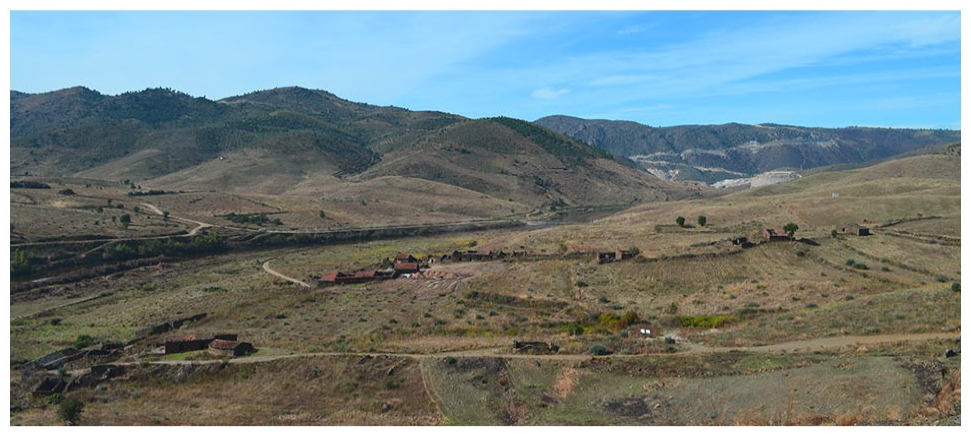
East view of the valley from the site of Castelinho (Cst).
Region’s vegetation reflects these climatic and physiographical constraints. Evergreen oak woodlands (e.g. Quercus suber and Q. rotundifolia) along with Juniperus oxycedrus (Aguiar, 2020; Amigo et al., 2017) are the dominant tree formations. However, Pinus pinaster formations are also frequent. Arbutus unedo, Pistacia terebinthus and Viburnum tinus composed most shrub formations (Aguiar and Vila-Viçosa, 2016; Costa et al., 1998). Close to the riverbed or in shaded or humid slopes, Alnus glutinosa, Salix spp., Fraxinus angustifolia and other riverine species are frequent (Portela-Pereira and Rodríguez-González, 2020). Q. rotundifolia along with Q. faginea and Q. suber are common in sunny and exposed slopes (Aguiar and Vila-Viçosa, 2016).
Human occupation
The earliest Holocene occupations recorded in the Lower Sabor were found at Foz do Medal. Here, several negative features – pits and postholes – and few hearths, as well as quartz-dominated lithic industry, document three consecutive Mesolithic phases, from the mid-eighth millennium cal. BC to the early-fifth millennium cal. BC (Gaspar et al., 2016; Tereso et al., 2023). Such evidence demonstrates the area was frequently visited by the last hunter-gatherers. This is a rare case of human occupation in inner Iberia dating to these moments and a good opportunity to characterize plant exploitation in this period.
Evidence from the earliest Neolithic or Chalcolithic farmers in the valley is sparse. So far, only at Quinta do Rio 14, structures and artefacts have been found in a highly disturbed stratigraphy (Gaspar et al., in press). Although monumental sites from the third millennium BC, such as Crasto de Palheiros (Sanches, 2008), Castanheiro do Vento (Jorge et al., 2003) and Castelo Velho (Figueiral and Jorge, 2008) can be found in the region, usually in high visibility locations, the association between sites of this type and the less perennial archaeological evidences, such as those from the Sabor valley is still a matter of debate at an Iberian level (Lillios, 2019).
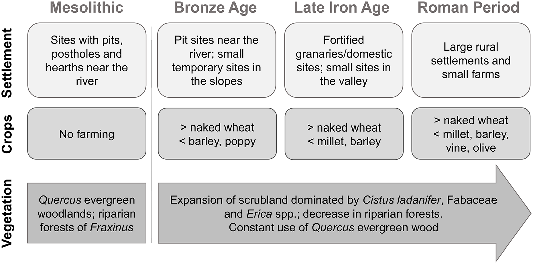
Abundant Bronze Age evidence was identified, particularly from c. 2000 BC to 1200 BC. Even if small sites like Quinta do Rio 14, continued to be visited during this period, ampler structural evidence exist in flat fluvial platforms just a few meters above the river level that revealed funerary and domestic structures, particularly pits – Foz do Medal and Terraço das Laranjeiras (Gaspar et al., 2014a, 2014b; Jesus et al., 2020; Martín-Seijo et al., 2017) – as in other sites of this chronology throughout Iberia (González, 1994; Lillios, 2019; Márquez Romero, 2001; Rodríguez et al., 2010). Stratigraphy, radiocarbon dates and archaeobotanical data, demonstrate these platforms were recurrently used, probably for agricultural purposes (Jesus et al., 2020).
Archaeological evidence from the Iron Age date to a period between the fourth century BC until the turn of the Era, but most are integrated in the Late Iron Age (second–first centuries BC). The main sites are Quinta de Crestelos and Castelinho, located in strategic hilltops overlooking wide areas of the valley. These were characterized by elevated granaries protected by an intricate system of walls, ditches and fortified entrances (Pereira et al., 2015; Santos, 2015; Seabra et al., 2020). Such concentrations of storage facilities surrounded by massive defensive systems can be found elsewhere in Iberia (Alonso et al., 2008), particularly in the northwest (Teira-Brión, 2019; Tereso et al., 2013b) and are evidence of complex social realities in which crop production, storage, protection and, eventually, distribution played determinant roles.
During the Roman period, from the first century AD to the third and fourth centuries AD, there was a proliferation of small rural farmsteads, reflecting a different approach to the way this territory was organized and exploited, as in other areas of the western empire (Smith et al., 2016). Sites such as Foz da Ribeira do Poio, Cabeço da Grincha, Olival da Santa, Laranjal and others, were part of a network meant to take full advantage of the natural resources and agricultural capabilities of the valley (Tereso et al., 2020). While some of these were occupied over a short period, Quinta de Crestelos retained much of its size and importance over several centuries, as proven by the existence of a large cella vinaria, furnaces, ovens and a large horreum, a necropolis as well as successive building reconstructions.
During the Middle Ages, human presence in the valley witnessed a steady decline concerning material and constructive evidence (Tereso et al., 2016b). Only during the Modern period, the valley saw the appearance of new rural sites meant to explore its many agricultural capabilities, following a trend similar to other areas of the Douro basin in mainland Iberia. Quinta de Crestelos, Quinta do Medal and Quinta das Laranjeiras, were three of these large estates, owned by local elites, producing wine, olive oil, wheat and rye (Correia, 2019). In the late 20th century, most of these farms were already abandoned as their inhabitants and descendants receded to several small villages in the area, even if most of this area was still cultivated.
Materials and methods
Archaeobotanical data
Archaeobotanical analyses were restricted to plant macroremains since no suitable contexts for pollen analysis were available. Carbonization was the only form of preservation. These studies were carried out in thirteen sites (Figure 2), chronologically spreading from the Mesolithic to the Modern period, with time gaps (Figure 3). From now on, reference to the sites will be made using a three-letter code (see Figure 3 and the Electronic Supplemental Material).
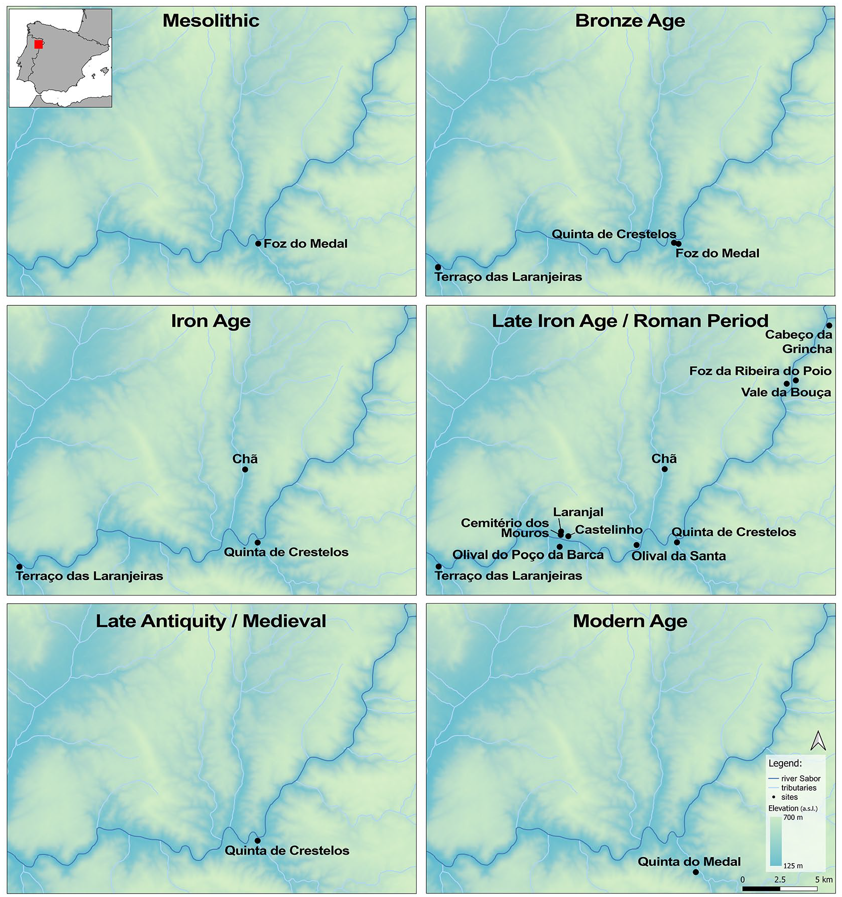
Location of the Lower Sabor region in the Iberian Peninsula (red square) and the sites included in the study by the six chronological phases (Digital Elevation Model – EU-DEM v1.0 Copernicus Programme).
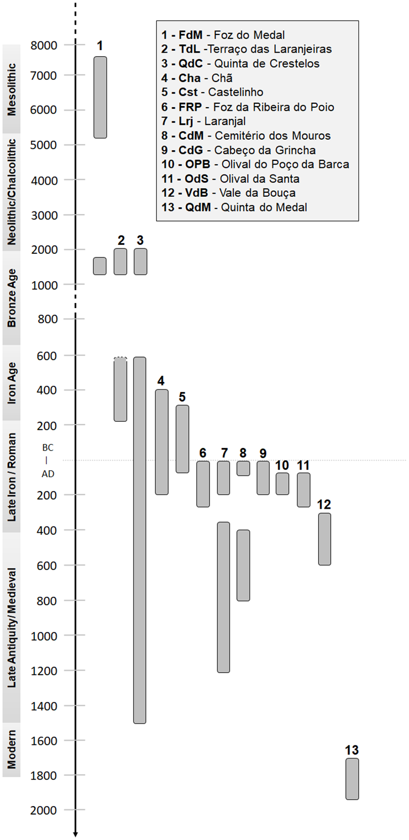
Distribution over time of archaeobotanical data included in this study.
Most sites are settlements with domestic structures and refuse deposits where sampling was performed (information about the sites is available as Supplemental Material – ESM1). Although sampling strategy varied between sites – see ESM2 for information regarding number of contexts (=stratigraphic unit) and volume of sediment analysed per occupation – flotation was consistently done with 0.5 mm meshes. Laboratory analyses followed standard procedures with the anatomical observation of the three diagnostic sections for charcoal fragments and the comparison with wood anatomy atlases (e.g. Schweingruber, 1990). For carpological remains, morphological observation was performed and fruits and seeds were compared to modern reference material from the Herbarium of the University of Porto (PO) and atlases (e.g. Jacomet, 2006; Neef et al., 2012).
Some sites have more than one phase, resulting in 20 occupations (i.e. combination of site/phase). Four occupation phases from three sites were excluded, namely the eventual Neolithic and Bronze Age contexts from Quinta do Rio 14, due to difficulties in ascribing sampled contexts to specific chronologies, and the Medieval phases of CdM and OdS because the number of sampled contexts was too low. Available dataset ranges from the Mesolithic to the 18th/19th century (Figure 3). Each site was assigned to a broad chronology: Mesolithic, Bronze Age, Iron Age, Late Iron Age/Roman period, Late Antiquity/Medieval and Modern Age. Aggregation of Late Iron Age and Roman data, on one side, and Late Antiquity and Medieval, on the other, served the purpose of preventing data fragmentation in quantitative analyses. Besides, the chronological boundaries defining the end of the Iron Age and the effective beginning of the Roman period can be debatable in the region (Lemos, 1993).
Not all chronologies are represented equally. Data from the Late Iron Age/Roman period is the most frequent, corresponding to 50% of the occupations studied (n = 10) and more than 60% of the contexts analysed. On the other hand, the oldest period (Mesolithic) and the most recent (Modern Age) are only represented by one site each, with 17 and 18 contexts, respectively.
To overcome these constraints of highly variable number of fragments analysed, we opted to explore ubiquity, that is, the occurrence of taxa in a context, a parameter that is independent from the number of fragments, was used by default. However, the use of absolute fragment count, broken down into phases was still used when analysing wood charcoal, considering the massive data recovered (c. 50,000 fragments analysed). Along with the metrics used, complementary information provided by the analysis of pollen records or written sources was also incorporated.
Data analysis
Original charcoal data from all sites is available in ESM3. Data was processed by transforming all NA in 0 for both diversity and ubiquity. Then, a factor analysis for all taxa by all chronologies was done and proceed to data transformation to logarithm (base-10 logarithm, except for zeros) as ubiquity and diversity followed a log-like distribution. To test if there were significant differences concerning different chronologies, a Kruskal–Wallis was used and, then, a Pairwise Wilcox Test was performed to check the significant differences between all pairs of chronologies. Differences were tested using absolute and relative frequency of diversity and ubiquity as well as selected groups such as taxa of economic interest (e.g. Castanea sativa, Olea europaea, Vitis vinifera) and taxa indicators of disturbance (Cistus spp. and Erica spp.). All statistical analyses were performed in R version 4.0.4 (R Core Team, 2021).
Discrepancies in the distribution of data prevented the use of similar quantitative approaches in the analysis of carpological assemblages, although c. 32,000 units were identified. These were instead observed in qualitative terms (ESM4). Usually, despite some very specific cases (e.g. storage structures with considerable carpological remains), the preservation of fruits and seeds is rarer than wood fragments and may be underrepresented in the archaeobotanical assemblage, as well as conditioned by the number of sampled contexts.
The number of carpological remains only takes into consideration units (whole fruits/seeds or fragments with hilum/scutellum) but to calculate taxa ubiquity, fragments were also used. As such, when number of fragments (e.g. seed fragments without hilum) is superior to those of units (e.g. whole seeds and fragments with hilum) and found in a higher number of contexts, the ubiquity may be superior to the actual number of units recorded. The number of remains from Cistus ladanifer correspond exclusively to fragments. They were included in the table because there are no units preserved and the minimum number of capsules could not be calculated as a result of their high fragmentation.
Ecological interpretation of each taxon follows vegetation studies available for the study area (Aguiar, 2020; Aguiar and Vila-Viçosa, 2016, 2017; Portela-Pereira and Rodríguez-González, 2020) as well as information obtained in field trips.
Results
Charcoal
Charcoal analyses from 639 contexts in 13 sites resulted in the identification of 53,168 fragments representing 44 taxa. After the exclusion of several redundant or poorly informative identifications (e.g. taxonomic diagnose at the family level – Fagaceae – when Quercus sp. evergreen and Quercus sp. deciduous were already present), a total of 46 466 charcoal fragments from 36 taxa were considered for this study.
One third of taxa (n = 12) comprise more than 95% of the fragments identified. The remaining 24 taxa represent two thirds of the diversity but none reached 1% of the fragments identified in the complete charcoal assemblage (ESM3). Quercus sp. evergreen was the most frequent and ubiquitous taxon identified, being present in more than 65% of the contexts analysed. However, we must stress that there is no direct relation between the number of fragments and ubiquity (Figure 4). This was showed by Fabaceae that provided fewer fragments than Juniperus sp., Erica australis/arborea or Arbutus unedo but was present in more contexts than these taxa.
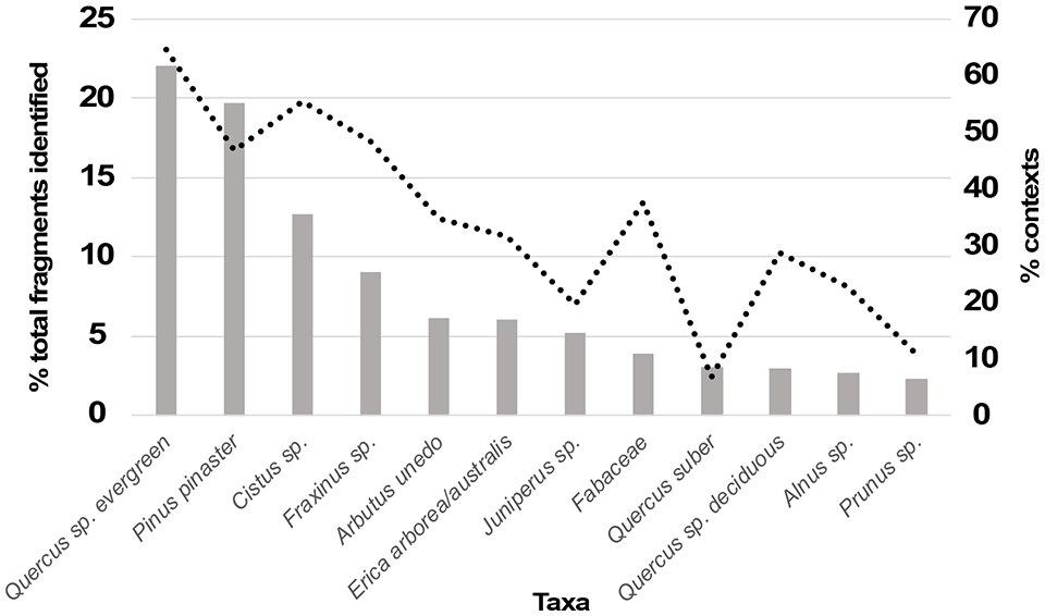
Relative frequency of fragments (columns) and the ubiquity (expressed as a percentage, dotted line) of the most frequent taxa (relative frequency >1%) for the Holocene sites of the Lower Sabor (ordered by decreasing relative frequency).
Fraxinus sp., Juniperus sp. Pinus pinaster and Quercus sp. evergreen (including Q. suber) are present during the complete diachrony. On the other hand, taxa identified in only one chronology, representing a scarce number of fragments, are mostly concentrated in the Late Iron Age/Roman period (Betula sp., Hedera sp., Laurus nobilis and Taxus baccata), the only fragment of fern (Pteridium aquilinum) from the Iron Age at TdL and the exclusive identification of Castanea sativa in the valley along with the Cotinus coggygria (an exotic, ornamental plant) at QdM, from the Modern Age.
Late Iron Age/Roman, with 33 out of the 36 taxa, is the most diverse period, but also the one with more contexts and charcoal fragments studied, followed by the Iron Age and Modern Age with 28 and 25 taxa, respectively. Bronze Age and the Late Antiquity/Medieval have 19 and 16 different taxa each and, lastly, the Mesolithic with only six taxa identified. The latter was, as stated before, the less diverse period, although it was not the one with the smaller quantity of fragments analysed. Bronze Age had only a few more fragments analysed but its diversity was nearly three times higher (6 vs 16 different taxa).
Pairwise comparisons between chronologies showed some differences between pairs. For diversity (absolute values), differences between successive periods were significant between Bronze Age and Iron Age and Iron Age and Late Iron Age/Roman period (p-value <0.05). An increase in diversity was observed from 15 taxa in the Bronze Age to a peak of 33 in Late Iron Age/Roman period. Between the Bronze and Iron Age, Arbutus unedo and Cistus sp. saw a rise in frequency, followed by a decrease in following periods. Tree taxa, namely Fraxinus and Quercus sp. evergreen, faced a decrease in frequency between Bronze and Iron Age. For Late Iron/Roman period both species showed a stable frequency, comparing to Iron Age. The same trend of stability was still observed for Quercus, however, Fraxinus sp. experienced an increase in frequency from Late Iron Age to Late Antiquity/Medieval. P. pinaster reached a peak in Late Iron Age/Roman, afterwards dropping to residual values found in previous periods.
For relative frequency, that is, relative proportion of taxa within each site, no significate differences were detected. Concerning ubiquity (absolute values), for consecutive periods, variations were only found between the Bronze and Iron Age periods. When evaluating relative frequency of taxa by site, significant changes in ubiquity for consecutive periods were also found between the Late Antiquity/Medieval period and the Modern Age. However, fluctuations between pairs were also observed from non-consecutive periods, for both diversity and ubiquity, as it could have been expected given the long diachrony under analysis. Differences were noted when comparing the Mesolithic and the Bronze Age with all other chronologies, except between these two periods. Concerning selected groups (economic-valued taxa and indicators of disturbance) no differences between periods were detected.
Fruits and seeds
Assemblages of fruits and seeds included 32,340 units (ESM4, Figure 5). Earliest remains date to the Bronze Age (TdL and FdM) and are mostly constituted by highly fragmented remains dating to the second millennium BC (c. 2000–1200 cal BC). Crops are not abundant and both caryopses and chaff of Triticum aestivum/durum/turgidum prevail. Hordeum vulgare was also recovered at both sites and, contrary to FdM, at TdL it is more ubiquitous than T. aestivum/durum/turgidum. Rare millet caryopses (eventually all Panicum miliaceum) were found at two pits from TdL. Two grains tentatively identified as T. dicoccum were also recovered at this site, along with few seeds of Pisum sativum and Vicia faba. Seeds of Papaver sp. were retrieved from both sites and a seed of Linum sp. was found at TdL but their domesticated character is not demonstrated.
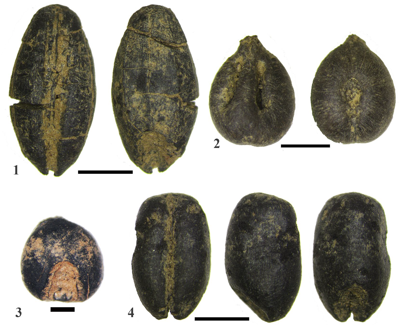
Fruits and seeds from Lower Sabor. 1. Hordeum vulgare; 2. Vitis vinifera; 3. Panicum miliaceum; 4. Triticum aestivum/durum/turgidum. Scale: 1 mm.
Iron Age (fourth–second centuries cal BC) remains are rare and come from three sites: TdL, QdC and Cha. They do not bring any novelty to the assemblage of crops from the valley, but the small number of contexts and plant remains analysed must be taken into consideration. Preponderance of T. aestivum/durum/turgidum, P. miliaceum and H. vulgare is noticed, as well as the presence of a single Vitis vinifera pip at each site.
At Late Iron Age/Early Roman period sites, carpological remains are much more abundant, particularly at Cst and QdC, in which several storage facilities dating to the second/first centuries BC have been excavated. These show a great preponderance in T. aestivum/durum/turgidum caryopses which are both the most abundant and ubiquitous carpological remains (>17,000 grains) although chaff is almost absent (<10 rachis nodes). P. miliaceum is more abundant than H. vulgare, particularly at QdC, but the latter is more ubiquitous than P. miliaceum at Cst. Pulses are almost absent and are even rarer than grape pips and pedicels. Stones of Olea europaea are recorded for the first time. Some elevated granaries from QdC were used in the first and second century AD at the same time when several small Roman farms were being founded throughout the valley. Crops were basically the same, but in the farms they were found in very small amounts.
First record of Secale cereale comes from the c. third century oven of CdG and it was directly radiocarbon dated (Seabra et al., 2023). It is also recorded at Late Antiquity (fifth–eighth century AD) and Medieval (10th–12th centuries AD) levels of QdC, along with the other cereals already existing in the area. The only crop found at QdM, dating to the 18th–19th centuries is grapevine.
Wild edible fruits/seeds are rarely found. These are restricted to few Rubus sp. seeds and a single Quercus acorn. Ruderal/weedy taxa are abundant, particularly in the Bronze Age pits of TdL and at the Late Iron Age/Early Roman levels of Cst and QdC. Fragments of capsules of Cistus ladanifer are frequently found at Cst and QdC in association with charcoal from the same species, being a by-product of fuel gathering.
Discussion
Archaeological works conducted in Lower Sabor provided a collection of archaeobotanical remains recovered in an extensive number of sites encompassing several periods of the Holocene. However, the absence of reliable data from some periods did not allow a full diachronic perspective (Figure 6). This was particularly evident for the period between the Mesolithic and the Bronze Age, as well as for the centuries between the Late Medieval period and the 18th century. Still, data gathered at Lower Sabor allow us to address key-moments in landscape and agriculture history in this bioclimatically Mediterranean area and integrate it in north-western Iberian dynamics, identified in the extensive palaeoenvironmental and archaeobotanical records of Atlantic areas.
Synthesis of the main trends in settlement, crops and vegetation from the Mesolithic to the Roman period.
Vegetation and landscape
Relying on charcoal assemblages to make inferences of past landscape structure and composition must be made with caution since the perceived diversity may be conditioned by human selection (Picornell-Gelabert, 2017; Vaz et al., 2017a) and methodological approaches (Piqué, 1999).
Although the high number of wood fragments and contexts analysed diminishes representativeness problems, we still opted to (1) explore ubiquity to avoid overestimating the contribution of largely represented taxa; (2) directly address potential biases derived from past selective behaviours that were detected in some of the sites (e.g. Seabra et al., 2020; Tereso et al., 2018a), and (3) integrate charcoal data in the larger regional trends in vegetation by comparing it with the nearest palynological studies.
Charcoal analyses reveal the exploitation, in all periods, of a diversified set of plant communities, from climatophilous formations dominated by evergreen oaks, most likely Q. rotundifolia, the most frequent and ubiquitous taxon, to riverine taxa such as Fraxinus sp. or Salix sp. With a single exception (Cotinus coggygria, identified at QdM from the 19th century), all taxa are native to the valley.
Our timeframe begins in the Mesolithic, in a period when palynological data for NW Iberia point towards a great development of oak forests, following the climatic improvements that characterize Early and Middle Holocene. In the more Atlantic regions, the post-glacial forest recover was fast, mostly since c. 12–11 ka cal BP, and during the Early and Middle Holocene regional broadleaf forests reached their maximum spatial cover, favoured by feeble human action and favourable climate (Iriarte-Chiapusso et al., 2016; López-Merino et al., 2012; López-Sáez et al., 2010; Mighall et al., 2023; Muñoz Sobrino et al., 2004). Nevertheless, Late Glacial and Early Holocene were characterized by rapid climate variability and a mosaic influenced by regional and local conditions. Last millennia before the introduction of crops and domesticated animals seem to have been characterized by a great development of oak forests. This became more visible and enduring after the 8.2 ka event.
In NE Portugal, archaeopalynological data from Prazo (Vila Nova de Foz Côa) suggest a well-developed forest in the eighth–sixth millennia cal. BC, dominated by Quercus deciduous with relevant presence of Olea and Pistacia (Monteiro-Rodrigues et al., 2008). Charcoal data document abundant evergreen Quercus, Arbutus unedo and Pinus pinaster. Here, as in FdM, Pinus pinaster was the only pine securely identified, although several charcoal fragments were identified as Pinus pinea/pinaster or even at the genus level (Monteiro-Rodrigues et al., 2008) most likely due to the poor preservation or small size of the analysed material which can prevent the proper identification between these two species. Charcoal data from Lower Sabor follows a similar trend (Figure 7), displaying both high percentages of tree taxa from climacic formations but, particularly, riparian arboreal taxa, which may eventually relate to the fact that data come from a single site, FdM, located just beside the river. Here Fraxinus sp. was the most frequent taxon albeit Quercus sp. evergreen was the most ubiquitous. The existence of extensive holm oak forests and, in the riverside and shady-humid depressions, of ash-dominated formations is a likely scenario.
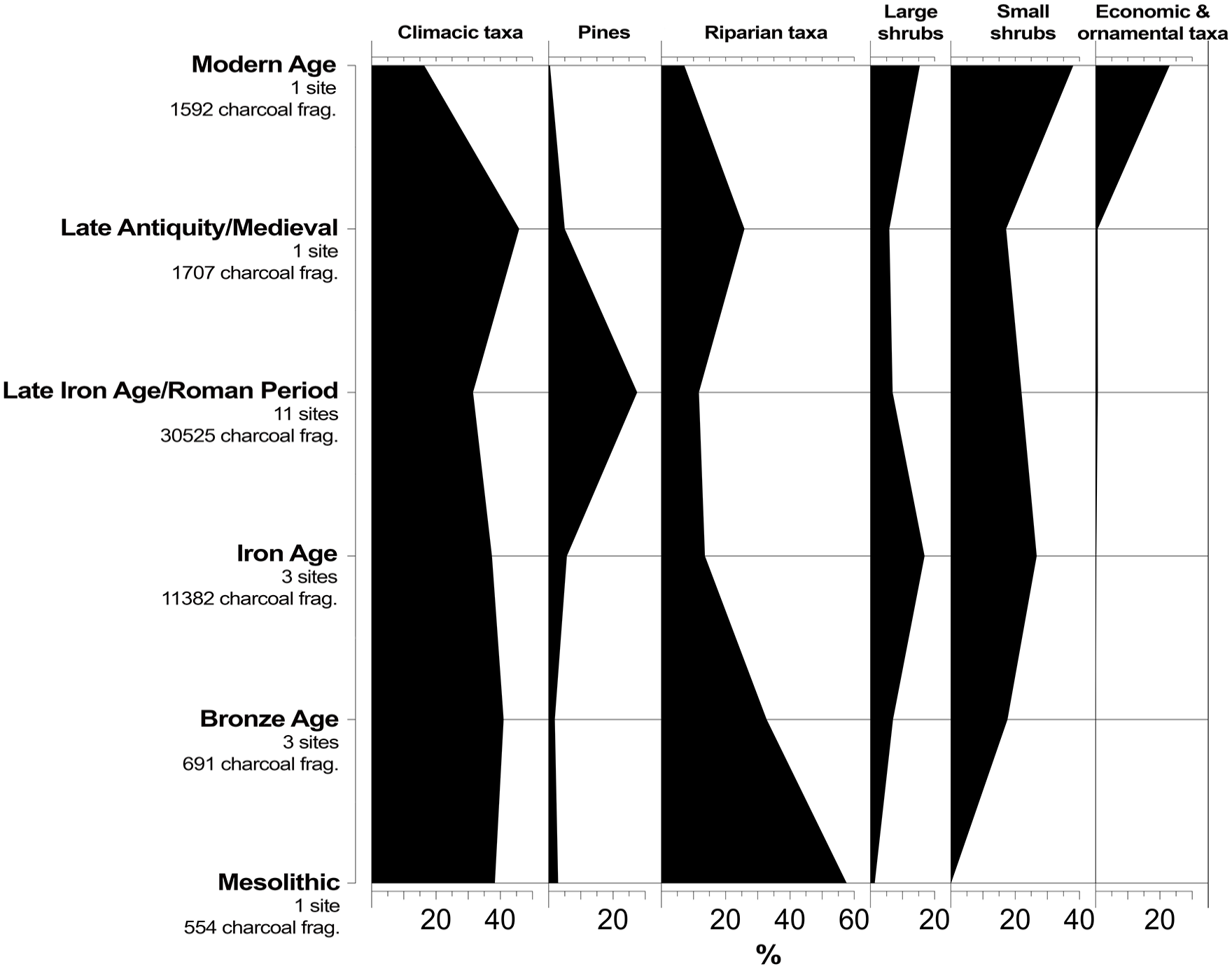
Diagram of main vegetation groups represented in the charcoal analysis with their distribution by chronological phase. Taxa included in each vegetation group: Riparian (Acer sp., Alnus sp., Betula sp., Corylus avellana, Fraxinus sp., Laurus nobilis, Populus sp., Ulmus sp., Salix sp., Tamarix sp.); Small shrubs (Cistus sp., Erica scoparia/umbellata, Erica australis/arborea, Fabaceae); Large shrubs (Arbutus unedo, Buxus sempervirens, Pistacia lentiscus, Pistacia terebinthus, Prunus avium/cerasus, Rhamnus/Phillyrea, Rosaceae Maloideae); Climacic trees (Juniperus sp., Quercus suber, Quercus sp. deciduous, Quercus sp. evergreen); Pines (Pinus pinaster); Economic and ornamental plants (Castanea sativa, Cotinus coggygria, Ficus carica, Juglans regia, Vitis vinifera); Olea europaea was included in ‘Large shrubs’ until the Iron Age and in ‘Economic and ornamental plants’ group afterwards; Prunus sp. was included in the ‘Large shrubs’ groups until the Modern Age, when it was moved to ‘Economic and ornamental plants’ group. Raw data available in ESM3.
From this period up until the beginning of the Bronze Age there is a noticeable gap in our data. For other areas in NW Iberia, although much regional differences can be detected, palynological data indicates deforestation, expansion of ruderal plants and coprophilous fungi as well as erosion episodes (López-Merino et al., 2010, 2012; Martínez-Cortizas et al., 2009; Mighall et al., 2023). Such trends suggest human pressure likely related to grazing and agriculture beginning in the mid-fifth millennium BC and visibly increasing in the second and 1st millennium BC, that is, during the Bronze Age and the Iron Age. Pollen data from Prazo suggest a decrease in forest area and an increasing presence of shrubs like Erica as well as indicators of fire in the sixth–fifth millennia BC (Monteiro-Rodrigues et al., 2008).
Differences between Mesolithic and Bronze Age charcoal assemblages in the Lower Sabor were expected. Still, Pairwise Wilcox Test did not reveal them in a clear way, possibly hindered by the much distinct sample size of both periods. However, by analysing frequency data differences are visible and suggest an increasing presence of shrubs, a clear indicator of anthropogenic deforestation. Data from FdM illustrate this change (ESM3). In Bronze Age levels, charcoal from A. unedo, Cistus sp., Erica spp., Fabaceae and O. europaea were retrieved but these taxa are absent from the Mesolithic levels of the same site. The latter only provided wood from tree taxa.
Increasing human pressure in the valley in the following periods led to enduring impacts in the landscape which are also revealed in the charcoal analysis. Pairwise showed differences between Bronze Age and Iron Age assemblages as well as between the latter and the Late Iron Age/Roman period, namely an increasing species diversity. This pattern likely reflects landscape changes that took place during the Iron Age and Roman period as result of changing social, economic and political dynamics. These are demonstrated in vast and increasing impacts in vegetation, as forest-loss is well documented in most palynological sequences. This regional trend seems to be the consequence of an increase in agricultural and grazing areas, but also in mining activities and the exploitation of wood in a scenario of demographic growth (Martín-Seijo, 2013; Muñoz Sobrino et al., 2005; Tereso et al., 2013a; Vaz et al., 2021).
Late Iron Age/Roman contexts in Lower Sabor provided the largest taxa diversity in all the time frame and taxa such as Betula sp., Hedera helix, Laurus nobilis or Taxus baccata are exclusive to this period. These are all native and palynological data from La Roya, north from our study area even documents an expansion of Taxus baccata in proto-historic and Roman times (Uzquiano et al., 2014). On the other hand, Late Iron Age/Roman sites provided more than half of the contexts sampled throughout the valley. It is not possible to exclude that the larger sampling effort and higher number of sites studied may have contributed to the overall increase in diversity found. However, the increasing number of sites found in the valley during this period is, itself, related to the intensification of resources exploitation and different settlement trends.
This scenario seems to be contradicted by the apparent increase in the absolute values of climacic trees, namely evergreen oaks, and also pines (Figure 7). Quercus sp. evergreen was, in both ubiquity and absolute terms, the most frequent taxa identified in the valley. This group encompasses a wide variety of evergreen oaks that cannot be differentiated using wood anatomy but considering the valley’s vegetation, Q. rotundifolia would probably dominate. Yet, as seen today, in a context of persistent human pressure Q. rotundifolia usually maintains a shrubby form eventually covering large areas (Aguiar and Vila-Viçosa, 2016). Thus, wood charcoal from evergreen oaks identified through charcoal analysis could either come from arboreal individuals or from shrubs. Such shrubby holm oak formations were likely frequent in these time periods when most paleoenvironmental records in Iberia document extensive deforestation (e.g. Bianco et al., 2023; López-Sáez et al., 2014) and, as mentioned before, the valley here studied shows increasing archaeological evidence of human occupation. On the other hand, anthracological records from the Atlantic north-western areas testify for a greater presence of wood from tree-species during Roman times, which may be related with a growing need of wood for construction, fuel and other uses, implying more extensive catchment areas (Martín-Seijo, 2013; Vaz et al., 2021).
Regarding P. pinaster, its growing relevance in the charcoal record may have different explanations, and to better document its evolution throughout the timespan of this study, it has been individualized in Figure 7. This species is native to the valley, as testified by its presence in the Mesolithic levels of FdM, as in the Early Holocene levels of Prazo and elsewhere in the region (Figueiral, 1995b; Figueiral and Sanches, 2003; Monteiro-Rodrigues et al., 2008). This was likely the most common, and possibly the only pine species in the valley as no other has been clearly identified so far, despite many charcoal was identified at genus level or as Pinus pinea/pinaster. Pinus pinea is native to Iberia but is more commonly found in meridional areas. Although recent plantations significantly extended its range further north (Franco-Múgica et al., 2005), there is no clear evidence of its presence in NE Portugal in pre-historic or Roman times.
Although P. pinaster was likely incorporated in climacic woodlands in the area, it can also behave as a pioneer taxon in human disturbed environments. Still, the sudden increase in its presence in the Iron Age and Roman periods can also be associated with human selection as suggested by previous studies: pine wood may have been selected for the construction of horrea in Cst and QdC (Seabra et al., 2020; Tereso et al., 2018a; Vaz, 2020) and favoured by its physical properties. Regarding Pinus sylvestris, there is evidence of its presence in the region in Mid- and Late-Holocene contexts, in assemblages dominated by thermophilous taxa (Figueiral and Carcaillet, 2005), whereas its presence was surely rare and decreasing. As can be perceived in subsequent periods, the importance of pines decreases again as settlement declines since Late Antiquity/Medieval times.
During the first century AD, the effective Roman occupation of the area led to a paradigm shift in the exploitation of the valley’s agricultural capabilities and thus in its settlement, as we have seen above. Excavations were able to identify several farmsteads (e.g. FRP, CdG, OdS, VdB) bearing structures associated with the production of wine and/or olive oil, such as presses and tanks, with few macroremains recovered (ESM3). These activities do not necessarily need the use of fire, and the charring of seeds might have occurred mostly when residues were used as fuel, but such remains have not been found so far. Management of fruit trees (e.g. through pruning) should made firewood available seasonally. It is possible that their small calibre would prevent a large number of wood charcoal to survive combustion, thus only with more samples and larger volumes of sediment being recovered could have these taxa be identified and, unfortunately, sampling effort in the small farmsteads was limited (ESM2).
Data from Late Antiquity/Medieval period as well as from Modern Age come from single sites, QdC and QdM, respectively, making broader interpretations difficult. During Late Antiquity and Medieval times, there is a small increase in the number of charcoal fragments of riparian taxa at QdC. This could eventually be attributed to the recovery of riverine forests, allowed by the decrease of the human presence in the valley through this timeframe, attested by archaeological data (Tereso et al., 2016a). However, it has not been perceived by the quantitative analysis (ESM3).
For Modern Age, quantitative analysis revealed strong differences from earlier phases, but the archaeobotanical record seems to be particular to the valley and the western Douro basin, making broader deductions more difficult. It is possible that data is reflecting changes in the settlement and economic exploitation of the valley, characterized by large farm estates held by landowners. Written accounts reveal that a vast section of the valley was appropriated by the Távoras, a powerful noble family which held several other large estates in the Upper Douro Region. Their domain in the valley was centred on the site of QdC, where a large farmhouse was built partially upon Roman and Medieval buildings. The valley was occupied with extensive olive and almond trees plantations, but also wheat, rye and vine (Correia, 2019). Archaeobotanical data corroborates the written sources. Absolute frequency of climacic trees (namely Quercus sp. evergreen) strongly decreases as did riparian taxa. On the other hand, shrubby taxa suffer a large expansion. Moreover, wood from economic valued taxa, particularly from Prunus spp. (possibly Prunus dulcis) is abundant at QdM.
Agriculture and settlement
Although Mesolithic contexts have been included here, there is no archaeobotanical evidence, in this chronology, to characterize the consumption of seeds, fruits or any kind of plant-based products in the valley. There is also no evidence for Neolithic and Chalcolithic crops, although some are found in other sites in the region. Cereals, poppy and pulses have been found in Buraco da Pala, Crasto de Palheiros (Figueiral and Sanches, 2003), Castelo Velho de Freixo de Numão (Figueiral and Jorge, 2008) and Castanheiro do Vento (Rodrigues, 2020) dating to the late fourth millennium and the third millennium cal BC.
In our study area, the earliest evidence for edible seeds and fruits dates to the Bronze Age (second millennium BC). From this moment on, until the Roman period, T. aestivum/durum/turgidum was the preponderant crop in the valley, having a determinant role in agricultural strategies and food choices. Free-threshing wheats are also dominant at Freixo/Tongobriga, the only Middle Bronze Age site in NW Iberia with abundant crops so far (Tereso et al., 2016a). Here, rachis fragments allowed the identification of tetraploid species. Freixo/Tongobriga is a good parallel to FdM and TdL, since all these sites are characterized by the presence of different pits. Such structures are usually interpreted as silos, but could have had other functions. These diverse functions have been demonstrated at TdL and FdM, where pits were used for funerary purposes, while in the Iron Age levels of TdL some were garbage pits. In both sites, pits are dug in permeable sedimentary contexts in the bottom of the valley, not prone for long-term storage as these would require non-permeable substrates on high places or slopes (Jiménez-Jáimez and Suárez-Padilla, 2020). Furthermore, data from our study region suggest the abundance of pits may be misleading (Jesus et al., 2020). At both sites, pits frequently intersect previous pits, demonstrating they were not all being used at the same time and suggesting the site was frequently revisited. As such, their number cannot be used to deduce large-scale agricultural production. The archaeobotanical content suggest they were used to dispose sub-products from early stages of cereal processing (Jesus et al., 2020; Tereso et al., 2023). These sites are, thus, relevant in the long-lasting investigation in the Iberian Bronze Age ‘campos de hoyos’ (Spanish for ‘fields of holes’), in which, unfortunately, carpological studies are seldom conducted (González, 1994; Márquez Romero, 2001; Rodríguez et al., 2010).
Regarding the Late Iron Age, the highly abundant carpological record from the Atlantic areas strongly contrasts with that from the Sabor valley. Therefore, the latter is now of the upmost relevance to properly address this period’s agriculture in the northwest and in western Iberia in general.
In our study area, several horrea in elevated and fortified granaries in Cst and QdC point to large-scale storage and production of cereals, as well as a change from underground airtight storage to aerobic storage in elevated granaries (Seabra et al., 2020; Tereso et al., 2018a). Despite some radiocarbon and stratigraphic evidence of short diachronic discrepancies in the abandonment of some structures, it is undisputable that Cst was a large fortified granary specialized in grain storage and the hilltop of QdC was used specifically for the same purpose. These sites diverge from other small and structurally frail Iron Age and Late Iron Age settlements in the valley. Cst and QdC may, thus, document not only relevant crop production and storage but also a complex reality in which grain accumulation and, eventually, distribution, may have played a significant social role. Structures at both sites were used to keep mostly fully processed grain of T. aestivum/durum/turgidum, but also H. vulgare and P. miliaceum. Both overlooked large open areas that contrast with the V-shaped profile recurrent in most sections of Lower Sabor and the preference for free-threshing wheat suggests access to fields with good soils and sun exposure. However, it is possible that crops from elsewhere were also stored in these granaries. It is disputable whether these sites document the gathering of large amount of surplus, since there is not enough data to calculate cereal yields or local demography, but they may have had a significant role, at least at a local level, in the accumulation, protection, maintenance and, possibly, distribution of cereals, with impacts in power relations between different groups within the community.
The absence of glume wheats in Late Iron Age sites of the valley contrasts with other north-western Iberian sites where T. dicoccum and, particularly, T. spelta are dominant crops (Teira-Brión, 2019; Tereso, 2012, 2020; Tereso et al., 2013b). T. spelta was usually stored as spikelets in different structures, such as pits (Seabra et al., 2018) and ground-based stone or wattle-and-daub structures (Figueiral et al., 2017; Leite et al., 2018; Tereso et al., 2013b). There is also evidence of fortified granaries such as the one of As Laias where spelt was the main crop (Tereso et al., 2013b). The particularity of north-western Iron Age sites regarding other Iberian regions, where glume wheats were abandoned or became minor crops, has been noticed before (Tereso, 2012, 2020). It has been interpreted as an adaptation to the more humid Atlantic climate and mountainous environment, where spelt would be a higher yielding cereal. It seems that the Lower Sabor is aligned with most of Iberia, including Middle Douro basin, where T. aestivum/durum/turgidum prevailed (Delibes de Castro et al., 1995).
At the same time, it must be noted that there are also cultural differences to be considered. NW Iberia is usually ascribed to what is known as the ‘Castros’ culture and the central/eastern areas of the Douro basin, bordering the Sabor valley, were a transition area to the influence of the Vettones peoples (Álvarez-Sanchís, 2011). Still, near the Sabor valley, glume wheats are the most abundant crop in the Late Iron Age/Early Roman levels of Crasto de Palheiros (Figueiral, 2008; Figueiral and Sanches, 2003; Figueiral et al., 2017; Leite et al., 2018) and Terronha de Pinhovelo (unpublished), suggesting a more complex mosaic. Eventually, the preference for T. aestivum/durum/turgidum instead of T. spelta and T. dicoccum may be due to the presence of good soils in the Sabor valley, suitable for these more demanding and productive crops. Thus, regarding agricultural choices, data from the Sabor valley document a scenario that is more complex and varied than previously thought (Tereso, 2012) in which local or regional environmental and social factors may have played a determinant role. Data here obtained demonstrates that to properly address Iron Age and Late Iron Age agriculture we need to encompass much of the environmental and cultural diversity of the region and that the great focus in the investigation of northwestern hillforts since the late 19th century is creating a research bias in this matter.
Romanization profoundly changed how the valley was exploited and, in consequence, its settlement. The fundamental change for this period was the foundation of many small farms throughout the valley in the first and second century AD and the abandonment of some Iron Age sites, such as Cst. Tanks and presses suggest production of wine and/or olive oil. Both species are documented in carpological and charcoal record, although rarely. Grape pips are more frequent than olive stones, but charcoal from olive trees is more common than grapevine wood. Still, considering the abovementioned archaeological evidence, both olive trees and grapevine were likely cultivated at least since the Roman period as in most Iberian regions (Peña-Chocarro et al., 2019). Full chronology and extent of such cultivation is difficult to assess due to the native character of both species, lack of archaeobotanical data and difficulties in distinguishing domesticated and wild species through seeds’ morphology and wood anatomy in small assemblages. Presence of charcoal from O. europaea in Bronze Age levels from FdM and TdL suggests the occurrence of wild olive. Concerning Vitis vinifera, the oldest identification occurred in the Iron Age level of QdC. As for Ficus carica, its wood is present, but rare, at least since the Iron Age and no seeds have been found.
Cereals remain stable when comparing to previous periods. This continuity contrasts with the referred changes in settlement, but cereals are almost absent from farms. In part, this can be related to differences in sampling strategy since fewer samples were collected at these sites and their excavation areas were usually smaller. In reverse, more sediment was collected in the horrea of QdC, some in use until the second century AD. Still, no granary was detected in the farms and even at FRP, where sampling was more extensive, cereals were rare and grape pips were more abundant (Tereso et al., 2018b). Hence, probably cereal cultivation was not a relevant element of these sites’ economies, contrary to what happens with the larger settlement of QdC, as these farms were likely specialized in olive and/or wine production. As mentioned above, QdC is located near an area where the valley has an open profile, more suitable for extensive cereal fields. As such, although the assemblage of crops, by itself, does not allow us to detect relevant changes in agriculture strategies in the valley during Roman times, the combined interpretation of the plant macroremains and the archaeological record suggest these changes did occur. There are no archaeobotanical records from Roman farms in the Atlantic areas.
Scarce carpological record for post-Roman periods does not allow the detection of relevant changes in crop choices, although there is a significant decrease in the number of sites known in the valley, which can represent an actual change in settlement pattern favouring other locations in the nearby plateaus. In Modern and Contemporary times, settlement was restricted to few small villages and farms that no longer favour areas near the river.
Secale cereale has been found in Late Antiquity and Medieval levels at QdC, but this crop was already recorded at the third century AD oven of CdG. This seems to fit the known chronology of this species dissemination in Iberia (Seabra et al., 2023). Despite its presence in NW Iberia, at least since the Late Iron Age, either as a crop or as a weed (Seabra et al., 2018, 2023), its cultivation was only truly spread in the Late Antiquity, from the third to fourth centuries AD onwards (Peña-Chocarro et al., 2019; Seabra et al., 2023; Tereso et al., 2013a). Medieval and Modern written sources document its relevance during Medieval and Modern times, together with wheat, vine and olive trees (Correia, 2019; Oliveira Marques, 1978) likely in a context of subsistence agriculture and small local trade. Further expansion of vine and olive is related to the establishment of larger farms owned by powerful landowner families with properties in the Douro region. This happened in conflict with local communities who were deprived of their lands and their means of subsistence, enhancing population loss in the valley area (Correia, 2019).
Conclusions
NW Iberia is a heterogeneous mosaic of climatic conditions where palaeoenvironmental studies are focused mainly on its Atlantic regions, favoured by the more frequent preservation of pollen records. Studies in the Mediterranean areas of this region are hindered by the scarcity of pollen evidence making plant macroremains analysis crucial to address the full dynamics of vegetation under contrasting climatic environments in NW Iberia. By integrating both wood charcoal and fruits/seeds this approach may also help relate such dynamics with changes in agricultural production that go largely unnoticed in many palaeoecological studies.
Although plant macroremains from our study area tally some of the palaeoenvironmental trends identified in previous studies from Atlantic areas, they also allowed the identification of specificities which have important implications for our understanding of key-moments in landscape history in NW Iberia. Data for the period from the eighth millennium BC to the sixth millennium BC revealed the exploitation of wood from Quercus sp. evergreen and Fraxinus sp. that were likely frequent in the area, reinforcing the maximum extension of Holocene forests suggested by palynological data from NW Iberia. Unfortunately, there is no data from the Neolithic and Chalcolithic, but records from Bronze Age sites document relevant changes in the landscape. Areas occupied by shrubs expanded as Cistus sp., Erica spp. and Fabaceae become recurrent in the charcoal record from this period onwards. Scrublands develop at the same time when the large and open fluvial terraces were being used for agriculture.
In agriculture there is a predominance of T. aestivum/durum/turgidum from the Bronze Age until Roman times when olives and vine area likely expanded. Although Bronze Age and Roman crop assemblages show similarities to other NW areas, the specificity of Late Iron Age crops in the Sabor Valley, namely the absence of hulled wheats, demonstrate a regional variability, eventually related with environmental and/or cultural factors, that must be taken into consideration while addressing agricultural history in western Iberia.
Quantitative analyses document a trend of increasing diversity of charcoal assemblages that continues until the Roman period, suggesting communities were expanding wood catchment areas, probably due to increasing deforestation. The Iron Age and Roman periods stand as shifting moments in environmental and landscape history throughout Europe and the Mediterranean (e.g. Berger et al., 2019), including Iberia and its north-western corner where the Roman conquest occurred later (see references above). Still, the transition between both periods occur in a short period of time, which is difficult to distinguish in palynological sequences. However, detailed archaeological and archaeobotanical information here analysed allowed us to detect particular and important differences. These suggest landscape changes in the Late Iron Age and Roman periods are related, at first, with the expansion of agricultural areas, namely for cereal cultivation and their accumulation in great storage areas, eventually associated with some demographic growth; and, in a second moment, with the foundation of small farms throughout the valley, for grapevine or olive cultivation, while cereal cultivation remained crucial. With population dispersal in this later phase, pressure over wood resources likely increased again. Despite the local character of such changes, they warn us about the complexity of this process, whose understanding demand complementary palaeoenvironmental data of different spatial and chronological scales. For the following periods, from the Late Antiquity to Modern Ages archaeobotanical data is scarce. Besides the cultivation of Secale cereale, Castanea sativa, eventually Prunus dulcis and the introduction of ornamental plants, the tendency for anthropization continues, culminating in the large estates of Modern and Contemporary times and, reaching its climax with the construction of the dams in the 21st century.
Supplemental Material
sj-docx-1-hol-10.1177_09596836241247299 – Supplemental material for Archaeobotanical data from the Sabor Valley reveal shifting moments in landscape and agriculture in NW Iberia during the Holocene
Supplemental material, sj-docx-1-hol-10.1177_09596836241247299 for Archaeobotanical data from the Sabor Valley reveal shifting moments in landscape and agriculture in NW Iberia during the Holocene by João Pedro Tereso, Cláudia Oliveira, Filipe Costa Vaz and Luís Seabra in The Holocene
Supplemental Material
sj-xlsx-2-hol-10.1177_09596836241247299 – Supplemental material for Archaeobotanical data from the Sabor Valley reveal shifting moments in landscape and agriculture in NW Iberia during the Holocene
Supplemental material, sj-xlsx-2-hol-10.1177_09596836241247299 for Archaeobotanical data from the Sabor Valley reveal shifting moments in landscape and agriculture in NW Iberia during the Holocene by João Pedro Tereso, Cláudia Oliveira, Filipe Costa Vaz and Luís Seabra in The Holocene
Supplemental Material
sj-xlsx-3-hol-10.1177_09596836241247299 – Supplemental material for Archaeobotanical data from the Sabor Valley reveal shifting moments in landscape and agriculture in NW Iberia during the Holocene
Supplemental material, sj-xlsx-3-hol-10.1177_09596836241247299 for Archaeobotanical data from the Sabor Valley reveal shifting moments in landscape and agriculture in NW Iberia during the Holocene by João Pedro Tereso, Cláudia Oliveira, Filipe Costa Vaz and Luís Seabra in The Holocene
Supplemental Material
sj-xlsx-4-hol-10.1177_09596836241247299 – Supplemental material for Archaeobotanical data from the Sabor Valley reveal shifting moments in landscape and agriculture in NW Iberia during the Holocene
Supplemental material, sj-xlsx-4-hol-10.1177_09596836241247299 for Archaeobotanical data from the Sabor Valley reveal shifting moments in landscape and agriculture in NW Iberia during the Holocene by João Pedro Tereso, Cláudia Oliveira, Filipe Costa Vaz and Luís Seabra in The Holocene
Footnotes
Acknowledgements
The authors would like to thank Cristiana Alves for the discussions concerning quantitative analyses and to the anonymous reviewers for their useful comments.
Funding
The author(s) disclosed receipt of the following financial support for the research, authorship, and/or publication of this article: The work of JT was supported by national funds through Fundação para a Ciência e Tecnologia (FCT), I.P. (![]() ); CO and LS were supported by Faculty of Sciences, University of Porto (FCUP) and FCV was funded by a Post-Doc contract in the scope of B-Roman FCT Project (PTDC/HAR-ARQ/4909/2020).
); CO and LS were supported by Faculty of Sciences, University of Porto (FCUP) and FCV was funded by a Post-Doc contract in the scope of B-Roman FCT Project (PTDC/HAR-ARQ/4909/2020).
The archaeological excavations and archaeobotanical analysis occurred under the framework of Plano de Salvaguarda do Património and were conducted under the general contractor for the Baixo Sabor Dam (Empreitada Geral do Aproveitamento Hidroelétrico do Baixo Sabor – AHBS), sponsored by the Portuguese Electric Company and executed by Baixo Sabor, ACE, which is was a consortium of ODEBRECHT/Bento Pedroso Construções, S.A. and LENA Construções.
The final stage of data acquisition and interpretation was carried out in the scope of the FCT projects B-ROMAN (PTDC/HAR-ARQ/4909/2020) and GrapeVision (PTDC/BIA-FBT/2389/2020), funded by national funds through FCT.
Supplemental material
Supplemental material for this article is available online.
References
Supplementary Material
Please find the following supplemental material available below.
For Open Access articles published under a Creative Commons License, all supplemental material carries the same license as the article it is associated with.
For non-Open Access articles published, all supplemental material carries a non-exclusive license, and permission requests for re-use of supplemental material or any part of supplemental material shall be sent directly to the copyright owner as specified in the copyright notice associated with the article.