
Abstract
Agropastoralism has prevailed in Inner Asia since the Bronze Age. It is an optimal subsistence strategy of inhabitants for adaptation to arid marginal environment. However, previous studies paid little attention to different development trajectories of this mixed economy within similar habitat. The Turpan and Hami Basins, located in eastern Tianshan Mountains of Xinjiang, are two typical desert oases with extremely dry climate, providing us with an appropriate region to investigate the issue. In present study, radiocarbon dates (n = 154) of eight typical sites in these two basins were reviewed and used to reconstruct the prehistoric chronology sequence prior to Han Dynasty (2200 cal BP). Then the data of botanical and faunal remains and stable isotope analyses (n = 159) of human diets from these sites were also reviewed for reliably revealing the subsistence economy pattern. Combining the time scale with multiple biological proxies, results show that, from the Bronze Age to early Iron Age, inhabitant subsistence in the Turpan Basin was dominated by livestock herding and supplemented by low-investment cereal crop cultivation, while the agriculture in Turpan Basin has developed significantly by the later period of Subeixi Culture. In contrast, agriculture-based economy was continuously developed in the Hami oases. Although the climate is very dry in both basins, temperature in warm seasons is much higher in the Turpan Basin. Besides thermal condition, size, range and convenient availability of highland pasture located at the southern flank of the Tianshan Mountains, are main driving factors leading to differentiated development trajectories of agropastoralism. Apart from that, cultural factors like economy, culture and technology communication along with population migration also impact local subsistence economy pattern.
Keywords
Introduction
Exploring the option of general and differential character of subsistence strategy is vital for revealing human-environment relationship (Anderson et al., 2007; Chen et al., 2015, 2020; Dong, 2018). Agropastoral subsistence strategy possesses both flexible mobility and relative stability for accessing survival resources in response to varied environment, such as seasonal moving herds to highlands for productive pasture or cultivating crops in lowlands (An et al., 2017, 2020). This mixed economy pattern is one of the frontier topics concerned by archaeologists because it clearly alters the pre-existing cognition related to pastoralists who were engaged only in mobile herding. Benefitting from increasing new archaeobotanical materials, faunal remains and isotopic records of human and domestic animal bones, the chronological sequence, dynamic history and detailed characteristic of agropastoral economy in Inner Asia was continuously updated (Frachetti, 2008a, 2012; Spengler et al., 2013, 2014). The earliest appearance of domestic animals and cereals were demonstrated respectively by sheep bones (8000 cal BP) found in the Ferghana Valley of Pamir Mountains (Taylor et al., 2021), wheat and barley grains (5200 cal BP) discovered from Tongtian Cave site in the southern Altai Mountains, northwest Xinjiang (Zhou et al., 2020). During the early Bronze Age, pastoral herding was increasingly integrated with crop cultivation in Inner Asia Mountain Corridor (IAMC) region where is the most important channel for early global diffusion of Eurasian crops, herds and technology.
The most representative example is examined in Dali site (4700 cal BP), stable isotopic analyses of sheep/goat bones demonstrates that millet plants, domesticated in northern China, were used as livestock fodder for pastoralist herding management (Hermes et al., 2019). Begash (4500 cal BP) site was determined as a winter campsite (Frachetti, 2008b; Schmaus et al., 2020). There were only a small amount of wheat and broomcorn millet seeds be discovered. Although cereal might not be locally cultivated near Begash site, the finding proved the earliest contact of cereal package from the East and West. It gives clear clues to reveal that pastoralists living in Inner Asia played a crucial role for the dispersal of cereal cultivars domesticated in Southwest Asia and East Asia, contributing to the formation of the early Silk Road (Frachetti et al., 2010). According to δ13C and δ15N biochemical records, pastoralists (3600 cal BP) primarily consumed meat of domestic animals in Adunqiaolu Site, which is a winter campsite (Cong et al., 2021; Jia et al., 2020). In addition, diverse crops including foxtail millet, broomcorn millet and naked barley, were likely cultivated in lowlands near the site, indicating seasonal transhumant herding practice (Tian et al., 2021). A recent study of caprine teeth by using cementum analysis method indicates that the feature of late Tasbas site (phase 2b and 3, 3300–2800 cal BP) is a year-round settlement occupied by part of indigenous pastoralists, who cultivated different kinds of cereals (Doumani et al., 2015; Schmaus et al., 2020). By the early Iron Age, cereal crops were much more intensively and widely involved in economic structure. Horticultural plants were introduced and cultivated, forming an important part of pastoralist’s subsistence. Especially, grape (Vitis vinifera) and Chianese date (Ziziphus jujuba) were managed by the ancient Subeixi Culture (3300–2000 cal BP) populations in the Turpan Basin (Jiang et al., 2009, 2013; Zhao et al., 2019).
Despite that versatile agropastoralism was pervasively adopted in Inner Asia, it varied across different geographical regions. Under the same temporal scale, regional differences of natural environment are important driving factors resulting in the diversity of agropastoralism strategy (Ventresca Miller et al., 2020). Food derived from livestock animal, including sheep, goat and cattle, were predominately consumed by inhabitants from low to high altitudinal sites in the Bronze Age (Doumani et al., 2015; Lightfoot et al., 2015; Murphy et al., 2013; Zhang et al., 2016). However, type of crops cultivated in this diverse niche with altitude gradients were distinctly affected by different cumulative temperature conditions. In middle and high elevation areas with low temperature, only domesticated cold-resistant C3 crops (like barley and wheat) were extensively cultivated (d’Alpoim Guedes et al., 2016). In low elevations with abundant heat, in contrast, not only C3 Triticeae crops but more C4 millet crops (like foxtail millet and broomcorn millet) were intensively cultivated (Frachetti et al., 2010; Jia et al., 2011; Jiang et al., 2015; Motuzaite Matuzeviciute et al., 2015, 2017, 2020a, 2020b; Spengler, 2015; Tian et al., 2021; Wang et al., 2021). This farming structure is also verified by human diet component, as carbon and nitrogen stable isotopic studies reveal that pastoralists consumed more C3 food in high elevation habitats in the IAMC region during the Bronze Age, while mixed C3 and C4 food consumption occurred at low valleys and basins (Wang et al., 2020).
Precipitation amount affects regional vegetation landscape, which will further lead to differences of subsistence pattern. The northern slope in eastern Tianshan Mountains is windward and influenced by humid moisture of Westerlies (Aizen et al., 2001; Chen et al., 2008, 2019; Feng et al., 2017). This favourable climatic condition contributed to the formation of expansive and productive pastureland, like the Barkol Steppe, where is suitable for livestock grazing. Osteological analysis of ancient horse bones demonstrated that the use of domestic horses and the presence of riding behaviour and equestrian technologies in the steppe, which forward promoted the rapid expansion of livestock husbandry (Li et al., 2020). Apart from that, pastoralists living in the Barkol Steppe also cultivated naked barley, wheat and a few millet (Tian et al., 2018). The Hami Basin with low altitude is situated on the foothill in the southern flank of eastern Tianshan Mountains. Moisture was blocked by high mountains. Therefore, precipitation is very low and climate is extremely arid. Despite the hyper arid environment, oases developing in the basin are exclusively fed by ice and snow melt-water (Hu et al., 2003). Intensive and centralised agriculture was primarily carried out in these oases. Pastoral practice was supplementary element for supporting the continuous survival of local sedentary residents (Wang et al., 2021).
The pre-mentioned phenomenon highlights the discrepancy of subsistence economy in the setting of disparate niche. Recently, the primary drivers of human-environment interaction mechanism between regional and continental scales in Eurasia were discussed (Dong et al., 2023). However, were there significantly different patterns existing among human subsistence strategies in similar natural environment in various localised areas? If existed, what were the driving factors that influenced these differences? These key issues associated with human survival history in Inner Asia are lacking of examination. The Turpan and Hami Basins in Xinjiang, northwest China (Figure 1a), with parallel natural conditions involve geological conditions, hyper arid climate setting, biological resources and cultural features. Extreme dry climate is beneficial to plenty of valuable organic relics, being well-preserved in desiccated form (Chen et al., 2012, 2022; Gong et al., 2011; Jiang et al., 2007a, 2007b, 2009, 2013, 2015; Sheng et al., 2019; Tian et al., 2022; Wang et al., 2021; Zhang et al., 2019; Zhao et al., 2019). Topography, arid climate and vegetation types are similar in the Turpan and Hami Basins (Figure 1; see in the Supplemental Material 1). It should be noted that the temperature in warm seasons in the Turpan Basin is much high than the Hami Basin. That provides us with ideal research areas to explore the development history and the comparative difference of subsistence economy adopted by indigenous inhabitants living under similar dry conditions. The present research will contribute to further study on localised survival and adaptive methods in hyper arid region of Inner Asia.
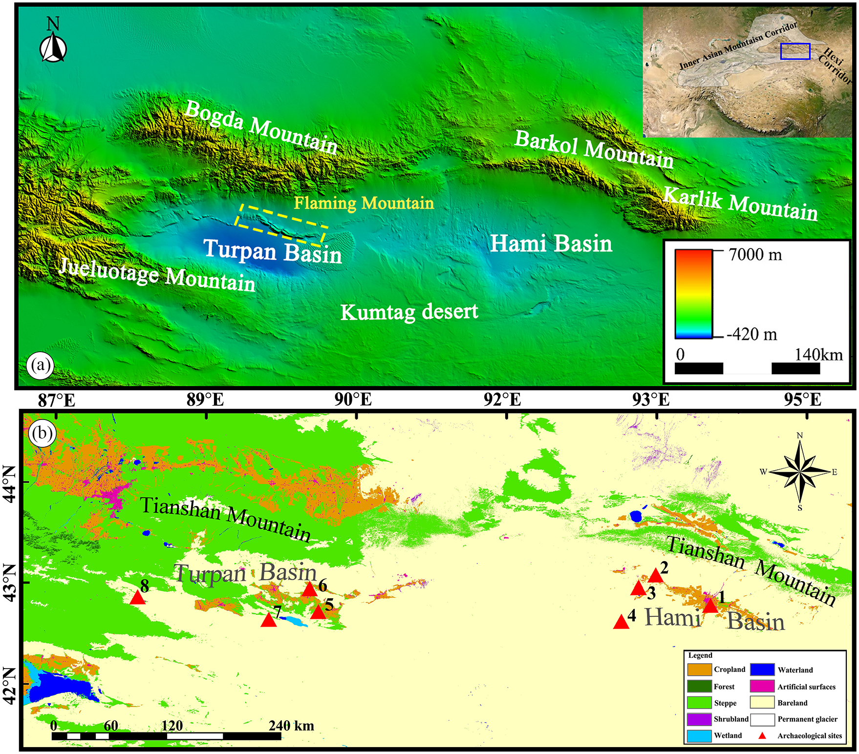
(a) Topography of the Hami and Turpan Basins and surrounding mountains. (b) Land cover around the Hami and Turpan Basins. Location of archaeological sites mentioned in this study: 1. Tianshanbeilu; 2. Yanbulake; 3. Wupu; 4. South Aisikexiaer; 5. Yanghai; 6. Shengjindian; 7. Jiayi; 8. Yuergou.
In this study, all published AMS radiocarbon dates prior to historical Han Dynasty (2200 BP) from eight typical sites in these two basins were collected for determining the time scale of subsistence economy. Then analysing results of macro plant remains, domestic animal fauna and stable isotope data of human and livestock bones unearthed from these sites were systematically reviewed for revealing the dynamic process of subsistence economy during the Bronze Age and early Iron Age. The parallelism and difference of the economic pattern adopted by inhabitants living in similar oases niche was examined. The driving factors underlying the difference will be explored. This study will facilitate better recognition of the localised performance of agropastoral subsistence strategy and further understanding of the detailed diverse adaptation pattern of inhabitants in marginal hyper arid environments in Inner Asia.
Geographical and archaeological setting of the Turpan and Hami Basins
The Turpan and Hami Basins are two closed inter-mountain depressions, and are located at the southern flank in eastern Tianshan Mountains, Xinjiang, northwest China. The Hami Basin is approximately 300 km long and 150 km wide, covering a broad area of over 30,000 km2. The basin is surrounded by the Karlik Mountain and Barkol Mountain in the north, Nanhu Gobi in the south. Thus, the terrain of the basin is high in the north and south, low in the middle, sloping from northeast to southwest as well (Zhao and Qiao, 1994) (Figure 1a). The middle region is a diluvial plain at an altitude of 700–1000 m, where the Hami Oases with fertile lands patchily distributed (Qiao and Zhao, 1991). The lowest location is Sha Ehu at an altitude of 53 m. The Hami Basin lies in the heartland of Eurasia continent, far from ocean. Hence the climate is extremely dry, presenting a very low annual precipitation of only 43.6 mm (meteorological data of the Hami and Turpan Basins in 1981–2010, cited from National Meteorological Science Data Center, http://data.cma.cn/data/weatherBk.html.). Concurrently the climate is warm in summer season, average 24.6℃–26.1℃ (in 1981–2010). There is rich in solar-thermal resources, with over 3300 h of annual sunshine duration and a frost-free climatic period of 180 days (Hu et al., 2003). Overland rivers depend significantly on seasonal snow and ice meltwater from the Tianshan Mountains. Water resources concentrate in summer season. Natural vegetation mainly includes plants of Puccinellia, Leymus, Stipa, Phragmites, Alhagi, Tamarix, etc, which are resistant to drought, salinity and poor nutrient soil.
The Turpan Basin is about 245 km in length and 75 km in width, covering an area of about 15,000 km2 (Turpan Municipal Cultural Heritage Bureau et al., 2019). Two parts of the Turpan Basin is transversally separated by the Flaming Mountain (Figure 1a). Melt-water outflowing from the high Tianshan Mountains is partly blocked by the low Flaming Mountain and overflow in the northern side of this low mountain, that nourishes the Shanshan Oases (Xia and Hu, 1982). A large amount of weathered materials is carried and form thick deposits featured by relatively high terrain. Rivers partly flow southward through mountain gullies and feed the Turpan Oases in the south. Diluvial and fluvial deposits brought by rivers are relatively less in the southern part of the basin, where the elevation is below the sea level. The lowest location is Aydingkol Lake (−154 m). The surrounding mountains block moisture, resulting in extremely arid continental climate with low annual precipitation of only 15.3 mm in the basin (in 1981–2010). Likewise, very low and closed topography of the Turpan Basin makes it difficult to dissipate heat, leading to average 30.5°C–32.5 °C in summer (in 1981–2010), a maximum temperature reaching up to 49.6°C and a high annual evaporation of 2520–3167 mm (Bai, 2004). Water resources for organism living are primarily supplied by using water conservancy facilities, like notable Karez. Plants grow mainly in lowlands of oases. Dominant xylophyta plants are drought-enduring and salinity-resistant Populus and Tamarix. Other trees like Salix, and shrubs involving Caragana, Spiraea, Lonicera and Rosa, and herbaceous Alhagi sparsifolia, Sophora alopecuroides constitute a common vegetation landscape cover (Jiang et al., 2021a).
According to present archaeological records, Tianshanbeilu Culture, well-represented by Tianshanbeilu Cemetery (also named Linya Cemetery) in the Hami city, was firstly generated and developed in the Hami Basin as early as the Bronze Age (4000 cal BP) (Li, 1999; Guo, 2012; Han, 2005, 2007; Shao, 2018). Appearance of the earliest bronze culture is probably driven by Mongolian and European population migration (Gao et al., 2015; Wei, 2017) and their technology communication. Some bronze artefacts were significantly adopted from the Eurasian steppe, such as the Okunevo Culture (Lin, 2003), while bronze material and some manufacturing technology may come from the Hexi Corridor (Chen, 2017; Qian, 2006; Qian et al., 2001). Typological characteristics of various painted potteries indicate that the culture in the Hami Basin was deeply influenced by the Siba Culture from the Hexi Corridor in the east (Shao, 2018; Shui, 2020). Based on Tianshanbeilu Culture, subsequently Yanbulake Culture dated to the late Bronze Age and early Iron Age (3300–2200 cal BP) was developed in the Hami Basin. The archaeological sites of the culture mainly consist of Yanbulake, Wupu, Aisikexiaer and South Aisikexiaer Cemeteries. The culture is observably affected by cultural-economic communication between the West and East (Chen, 1991; Shao, 2018; Shui, 2020).
In the Turpan Basin, Subeixi Culture is the earliest relics of human activities with reliable dates, lasting from the late Bronze Age to Han Dynasty (3300–1800 cal BP). The culture is represented by Yanghai, Jiayi, Subeixi, Yuergou and Shengjindian Cemeteries. The population consists of medley European and Mongolian people (Shao, 2012). The technique for making lots of painted potteries discovered in Jiayi Cemetery (3000–2200 cal BP) refer to that practiced by farmers from western Ganqing region, northwest China (Wang et al., 2014). In Yanghai Cemetery (3300–2000 cal BP), exquisite bronze objects decorated with wild animal patterns may reveal the Scythian style prevailing in Central Asia steppe (Lu et al., 2004). Current archaeologically typological investigation shows that bronze objects, swirling grain patterns of painted potteries, wooden combs and figurines present similar feature between Subeixi and Yanbulake Cultures. It proves that there was an exchange existing in these two cultural communities living in the Turpan and Hami Basins at least 3000 years ago. Subeixi Culture (3300 cal BP) might be influenced by the westward expansion of Yanbulake Culture (3300 cal BP) (Guo, 2012; Han, 2007; Shao, 2012, 2018).
Materials and methods
Dating data
In this paper, an explicit AMS 14C chronological sequence was reconstructed to address the time scale for examining the dynamic evolution of subsistence strategies in the Turpan and Hami Basins from the Bronze Age to the early Iron Age (prior to 2200 cal BP). Annual plants, wool, wood, textile, human bones and animal bones compose the published radiocarbon dating materials. Wood samples with distinct old ages were excluded because of potential old carbon effect. After rigorous assessment, all 154 radiocarbon dates from eight typical sites, including Tianshanbeilu, Yanbulake, Wupu, South Aisikexaier in Hami and Yanghai, Jiayi, Yuergou, Shengjindian in Turpan, were selected (see in the Supplemental Material 2) and then were calibrated by using IntCal20 atmospheric curve (Reimer et al., 2020) and OxCal v4.4 (Bronk Ramsey, 2009).
Biological materials
In order to reveal the dynamic history of subsistence pattern employed by inhabitants in the Turpan and Hami Basins (4000–2200 cal BP), published macro botanical cereal crops, horticultural fruits and domestic animal remains discovered from eight sites were reviewed (Table 1). Because most of the published botanical and animal remains were collected by using random sampling method, they are prone to be described with qualitative approaches and lacking of quantitative statistical data. Thus, in the present research, only the classification results of these remains’ species in each site were listed. In addition, biochemical proxy carbon and nitrogen stable isotope data (n = 159) of human bones from five sites (Table 1, Figure 2), involving Tianshanbeilu, Wupu, Yanbulake, South Aisikexiaer from Hami and Yanghai in Turpan, were also collated for particularly exposing the shift process of diet component, which are closely associated with subsistence strategy.
Qualitative statistics of cereal crops, horticultural plants, animal remains from eight prominent sites in the Turpan and Hami Basins.
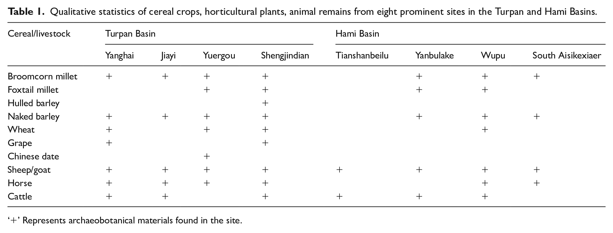
‘+’ Represents archaeobotanical materials found in the site.
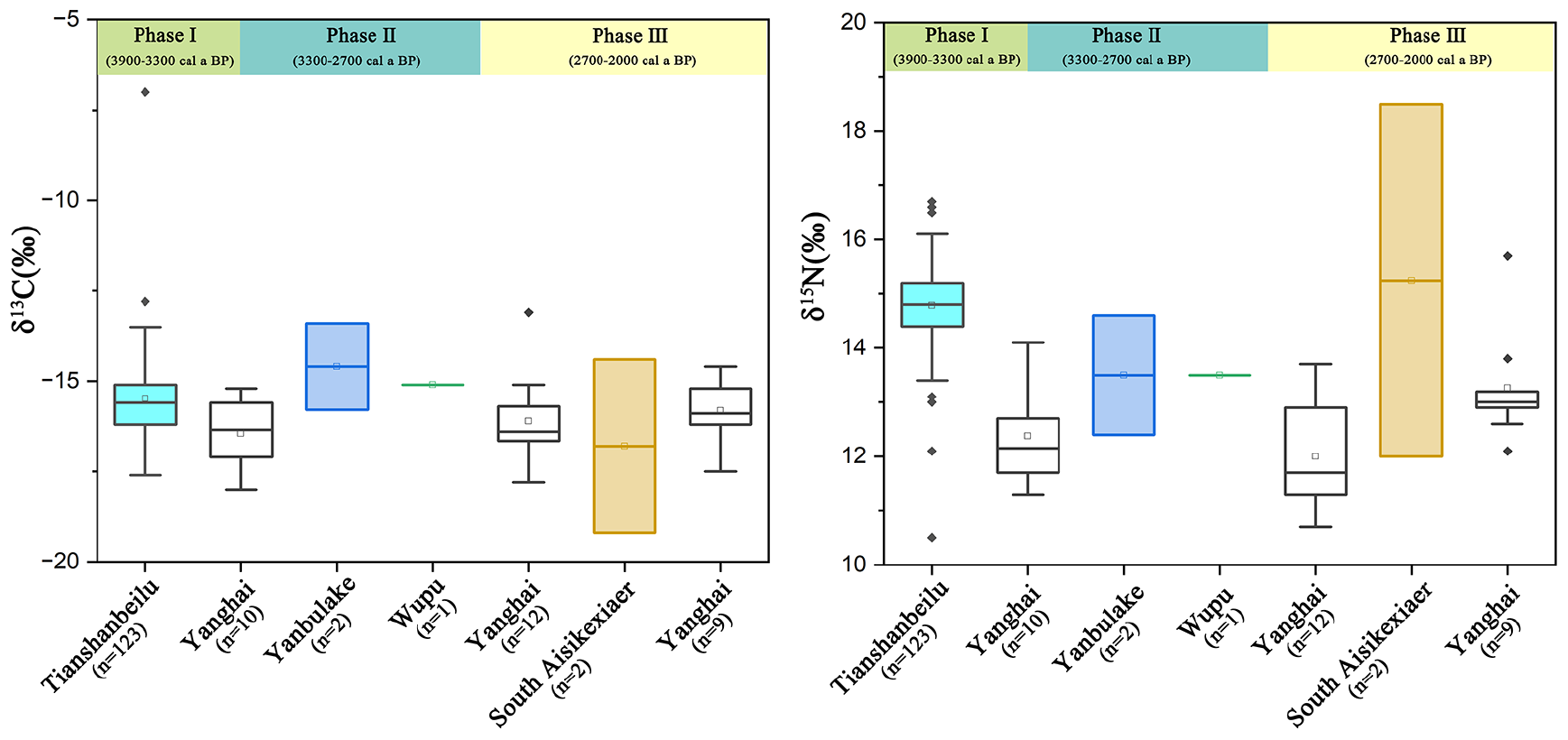
Box plots of δ13C and δ15N value of human bones in the Turpan and Hami Basins from the Bronze Age to the Early Iron Age.
Results
A reliable chronological sequence of prehistoric human activity in the Turpan and Hami Basins is reconstructed. In the Hami Basin, Tianshanbeilu Cemetery was continuously used in 3900–3000 cal BP belonging to the Bronze Age. Four cultural phases were divided according to archaeological findings (Tong et al., 2021). Therefore, four phases of radiocarbon dates were divided, from the early time period of 3900–3700 cal BP and 3700–3400 cal BP to late 3400–3200 cal BP and 3200–3000 cal BP. These dating results represent the chronology of Tianshanbeilu Culture, the first bronze culture in the basin. Then Yanbulake Culture gradually flourished, which is proved by radiocarbon dates from Wupu (3000–2400 cal BP, mainly centred on 2700–2400 cal BP) and South Aisikexiaer (2700–2400 cal BP) Cemeteries.
As to the Turpan Basin, the earliest prehistoric date (3300 cal BP) in late Bronze Age derived from Yanghai Cemetery, which continued to be used more than 1000 years (3200–2000 cal BP), covering the time period of main development stage of indigenous Subeixi Culture. A relative date framework of Yanghai Cemetery, summarised from archaeological stratigraphy, pottery typology, burial structure, was divided into four phases (Lu, 2017; Zhao et al., 2019). Combining this relative date order with direct radiocarbon dates, four diachronic phases were detailly determined as 3200–3000 cal BP, 3000–2700 cal BP, 2700–2300 cal BP and 2300–2000 cal BP. Thereafter, Jiayi (2900–2200 cal BP), Yuergou (2400–2100 cal BP) and Shengjindian (2400–2000 cal BP) sites mainly formed in the early Iron Age.
Based on these dates of each site, the prehistoric chronology order in the Turpan and Hami Basins can be broadly separated into three phases, depicting as Phase Ⅰ, early-middle Bronze Age (3900–3300 cal BP), Phase Ⅱ, late Bronze Age and early Iron Age (3300–2700 cal BP) and Phase Ⅲ, early Iron Age (2700–2000 cal BP). The reliable dates of site and archaeological culture are employed as the time scale of subsistence strategy in these two basins.
Dynamic development history of subsistence pattern in these two basins
The Hami Basin
In Phase Ⅰ 3900–3300 cal BP, the Tianshanbeilu Culture was mainly developed in the Hami Basin. Although discoveries of a large number of plant remains were referred, no systematically archaeobotanical analysis has been conducted so far (Chang, 1989). During Phase II (3300–2700 cal BP) and Phase Ⅲ (2700–2000 cal BP), the earliest crop remains appear in the Yanbulake Culture (3300–2400 cal BP), as evidenced by an extensive amount of cereal crop plants found in the Wupu (3000–2400 cal BP) and South Aisikexiaer Cemeteries (2700–2400 cal BP) (Table 1). Four cereal types, foxtail millet, broomcorn millet, naked barley and wheat were identified in the Wupu Cemetery. Moreover, a considerable number of intact foxtail millet and naked barley stalks and inflorescences were found, along with a small number of inflorescence and seed remains of other crops (Wang et al., 2021; Zhang et al., 2022). Seeds and a substantial amount of processed broken glumes, spikelet, inflorescences and stems of naked barley, along with broomcorn millet florets were discovered from South Aiskexiaer (2700–2400 cal BP) (Zhang et al., 2019). During archaeological investigation, barley rachis, broomcorn and foxtail millet florets were also discovered from the Yanbulake Cemetery. Although there was variability in the crop assemblage, it does suggest that multiple crops were cultivated in the Hami oases. However, no evidence was found for the cultivation of horticultural crops in the basin during this period.
Limbs of domesticated sheep/goat and cattle were discovered in 52 graves of the Tianshanbeilu Cemetery (Tong et al., 2021). In the Wupu Cemetery, bones of sheep/goat and cattle were also recovered (Xinjiang Institute of Archaeology (XJIA), 1992). Equestrian equipment such as a wooden cheek-piece of horse bridle with a direct radiocarbon date proves that the earliest equestrian techniques in Hami are dated back to 3000 cal BP (Schröder et al., 2016). The secondary products of domestic sheep and goat were widely used to make leather coats, boots and bags by Hami indigenous people (Schröder et al., 2016). In addition to domestic animal types, wild animal bones like deer and antelope were excavated from the South Aisikexiaer Cemetery (Zhou et al., 2002). Hunting implements, such as arrow shafts, bows and boomerang, were frequently found in tombs of the Tianshanbeilu, Wupu and South Aisikexiaer Cemeteries (Wang, 1983; Wang and Dang, 2011). It signifies that hunting practice was an important part of the early subsistence economy.
Carbon and nitrogen stable isotope results provide a useful reference for the diet construction of the indigenous people in the Hami Basin. In Tianshanbeilu Cemetery, human bones δ13C value (–15.5 ± 1.2‰, n = 110) indicate that their daily diet consisted of C3 and C4 foods (Wang et al., 2019). Only one human bone from the Wupu Cemetery was analysed, and the sample size was too small to describe the overall diet of the Wupu people (Wang et al., 2020). Mean δ13C values of human bones (−17.3 ± 0.9‰, n = 43) in the South Aisikexiaer Cemetery were more negative than that in the Tianshanbeilu Cemetery (−15.5 ± 1.2‰, n = 110), showing more C3 food (like naked barley) intake constituted the diet of Hami inhabitants in 3300–2400 cal BP. Mean δ15N value of all human bones from Hami are high than 12‰, proving foods deriving from animal were substantially consumed. The δ15N value had not changed significantly within the millennium, presenting relatively stable consumption of meat (Table 2, Figure 2). These results mentioned above reveal Hami inhabitants made full use of desert oases around seasonal rivers and groundwater resources to develop agropastoral economy during 3900–2400 cal BP.
Review of published δ13C and δ15N value of human bones in the Turpan and Hami Basins from the Bronze Age to the early Iron Age.
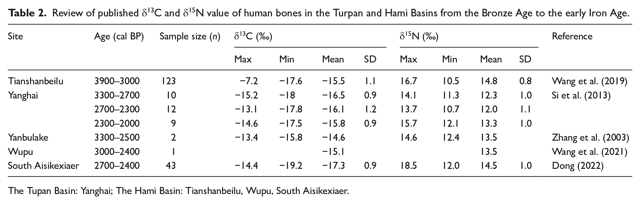
The Tupan Basin: Yanghai; The Hami Basin: Tianshanbeilu, Wupu, South Aisikexiaer.
The Turpan Basin
The earliest agricultural signal appeared in Turpan in Subeixi Culture. In Phase II 3300–2700 cal BP, broomcorn millet, wheat and naked barley were identified in the Yanghai Cemetery (Zhao et al., 2019), while remains of barley and broomcorn millet were discovered from the Jiayi Cemetery (Jiang et al., 2016). By Phase III 2700–2000 cal BP, both variety and quantity of crops increased in this region. Wheat, barley, foxtail millet and broomcorn millet were found in the Yuergou Site (Jiang et al., 2013), and wheat, hulled barley, naked barley, foxtail millet and broomcorn millet were recovered in the Shengjindian Cemetery (Jiang et al., 2015). A large amount of wheat straws with intact ears were found at the top of tomb M9 in the Shengjindian Cemetery (Jiang et al., 2015). Compared to previous period, planting scale of wheat, as a water-demanding crop, significantly increased, suggesting that the diversification of farming systems, improvement of farming management techniques and intensification of agriculture in the Turpan Basin at this time.
Advances in cultivation and irrigation management technology laid the foundation for planting horticultural trees in late Subeixi Culture. A grape vine discovered in the Yanghai Cemetery was directly dated to 2300 years ago (Jiang et al., 2009). The species was identified as Vitis vinifera, originating from the Mediterranean coast (Duan et al., 2017). That provides the earliest evidence of European variety introduction to the Turpan Basin. According to wood anatomy features, the grape vine was confirmed to have been cultivated locally for at least 6 years (Jiang et al., 2009), indicating that indigenous people mastered overwintering technique of grape. Grape seeds were discovered in the Shengjindian Cemetery, implying that grape was continuously cultivated. Another fruit tree that originated in the middle and lower reaches of the Yellow River Basin, Chinese date (Ziziphus jujuba), first appeared in the Yuergou Site about 2400 cal BP (Jiang et al., 2013). These fruit remains confirm the development of early horticulture in the Turpan Basin.
A large amount of animal bones was discovered in the Turpan Basin. In the Yanghai Cemetery, most of them are sheep/goat bones, including skulls, limbs and ribs. Some are cattle skulls, horse mandible and dogs (Turpan Municipal Cultural Heritage Bureau et al., 2019). Sheep skulls, some roast legs of lamb and mutton were buried in the Subeixi Site (Lu and Zheng, 2003). Horse and sheep bones were discovered in the house of Yuergou Site, and some skulls and ribs of sheep also appeared in the Shengjindian Cemetery (Zhang et al., 2013). DNA analysis results prove that bracer, bow and arrow sheaths were made of sheep/goat and cattle leather (Schröder et al., 2016). In addition, dairy products were also important animal resources that could be used. Dairy products in a leather bag were excavated from the Subeixi Site. Small amounts of bovine casein like milk product or milk adulterant were identified in hard black pieces of residue in a pottery bowl (Hong et al., 2012). Wooden sticks for stirring milk products, along with leather bags for loading milk were excavated in tomb IIIM17 (2300–2000 cal BP) of Yanghai Cemetery (Lu, 2020). Similar wooden stirring sticks were also found in the Yuergou Site, displaying the processing of dairy resources (Lu, 2020). Apart from that, discoveries of wooden drill and hearth, boomerangs, bows and arrows suggest that hunting always played an important role in subsistence economy of Turpan inhabitants (Jiang et al., 2018).
Mean δ13C value of Yanghai human bones illustrate their diet has no significant change from 3300 to 2700 cal BP (−16.5 ± 0.9‰, n = 10) to 2700–2300 cal BP (−16.1 ± 1.2‰, n = 12)(Table 2, Figure 2). The δ15N mean value are 12.3 ± 1.0‰ (n = 10) and 12.0 ± 1.1‰ (n = 12), showing continuous intake of lots of animal food. However, the diet of Yanghai residents changed significantly by 2300 cal BP, with a remarkable increase in carbon and nitrogen isotopic value (δ13C = −15.8 ± 0.9‰, n = 9; δ15N = 13.3 ± 1.0‰, n = 9). This information demonstrates inhabitants maintained an agropastoral economy, supplemented by horticulture cultivation and hunting from 3300 to 2000 cal BP.
Discussion
Similarity and difference of subsistence pattern between the Hami and Turpan Basin
In these two basins from the Brone Age to early Iron Age, remains of cereal crop and domestic animal were discovered in all archaeological sites (Table 1). All stable carbon and nitrogen isotope examination demonstrate local inhabitants not only eat foods deriving from animals but also intake C3 and C4 plant foods (Table 2, Figure 2), possibly originating from cereal crops, like wheat, barley and millet. These findings present a mixed economy pattern integrating agriculture and herding, namely agropastoralism, which extensively prevailed in ancient Inner Asia. Both communities in the Hami and Turpan Basins similarly apply agropastoralism as a flexible strategy to reduce survival risk under extremely dry conditions. However, population in Turpan preferring to pastoralism is evidently different from the population in Hami relying more on agriculture. In the Turpan Basin, a small number of cereal crops were found in the representative Subeixi cultural sites, like Yanghai, Jiayi and Yuergou (Jiang, 2022; Jiang et al., 2013, 2016; Zhao et al., 2019). It proves that local inhabitants carry out small scale dryland farming. In contrast to few remains of crop, a large amount of bones, leather products and woollen textiles deriving from livestock were recovered. Very low percent of dental caries and relatively severe abrasion of molars existing in Yanghai and Jiayi people refers meat was their staple food instead of cereal crop containing high content of carbohydrate (Liu et al., 2006; Zhang et al., 2017). These imply herding was probably the most important economic practice.
More evidences are available for illustrating details of livestock herding, and the ancestors who settled in the Turpan oasis probably reached as far as the northern slopes of the Tianshan Mountains. Fruits of Lithospermum officinale were used to arrange in triangle shape and decorate the edge of wooden bucket (Jiang et al., 2006). This plant only grows in the northern flank of Tianshan Mountains. Trees distributed in highlands like spruce and birch were commonly excavated from lowland sites in the Turpan Basins. Spruce timber was collected for tomb construction, making fire drilling tools, bows and arrow shafts, or as fuel (Jiang, 2022; Jiang et al., 2013, 2018, 2021a). Birch timber was processed into a wooden spoon (Jiang, 2022). Based on habitat and living niche of these plants, we propose parts of prehistoric inhabitants in the Turpan Basin were engaged in seasonal transhumance pastoralism (Jiang et al., 2021b). They vertically move to pastures with high elevation in summer and back to oases in late autumn when temperature rapidly decreases in high mountains.
As to the Hami Basin, on account of no report on botanical remains of Tianshanbeilu Cemetery, details of subsistence economy is absent in early and middle Bronze Age, only knowing local people carried out agropastoralism based upon the published staple isotope data (Wang et al., 2019). Since the late Bronze Age and early Iron Age (Yanbulake Culture), agriculture can be recognised as a major part of subsistence economy. Archaeological findings in typical sites of the culture, such as Yanbulake, Wupu, Aisikexiaer, Yaer, South Asikexiaer, are highly similar. These sites densely distributed along the Baiyang River in the western Hami Basin and are considered as a large settlement group (Wang and Dang, 2011). In Wupu Cemetery, several cereal species were identified. Crops with abundant residue after processing were commonly laid on Populus logs put on the entrance of tombs. Plentiful of crop remains even their whole plants were discovered (Wang et al., 2021). Apart from that, agricultural tools, like spade-shaped tool with long wooden handle for turning soil, also appeared (Wang, 1983). Resembling to Wupu, lots of barley stem fragments were general component of thatches for covering tomb entrance and an intact wooden shovel was preserved in South Aisikexiaer Cemetery (Zhang et al., 2019). Besides, in most of the typical sites of Yanbulake Culture, discoveries of desiccated cakes are frequent. Intact broomcorn millet florets are observed in some cakes. Millstones as an agricultural processing implement was a common type of artefacts. Moreover, near Yanbulake and South Aisikexiaer Cemetery, there were visible settlement features (Wang and Dang, 2011). Almost identical objects found in settlement and cemetery show occupation of these settlements by local inhabitants, who develop sedentary agriculture as their principal subsistence pattern. Livestock herding surely is another important economy practice according to archaeological findings associated with domestic animals. Herds might graze in oases near the Baiyang River bank. Water flow of this seasonal river is low and relevant oases range are finite. Therefore, to obtain maximal production for adapting to dry climate, agriculture with more yields in oases may be preferred by people of Yanbulake Culture.
Driving factors of the discrepancy
Although climate in both Hami and Turpan Basin is extremely dry, with annual precipitation of 15.3 and 43.6 mm respectively, monthly average temperature in Turpan is higher 6°C than Hami in warm seasons (in 1981–2010). Especially in summer, the Turpan Basin with average temperature above 30°C is the hottest and driest areas in China. This phenomenon is related to the lowest terrain and foehn wind influence. The climate condition generates severe challenges to agricultural production and livestock herding in the basin. Affected by high temperature and deficient water resources supply, crop yields are low and agricultural cultivation is in small scale (Jiang, 2022), which is revealed by discoveries of few crop remains. Thus, agriculture is regarded as a supplementary economy. Goat/sheep prefers to cool habitat. The herds were moved to highland pastures during summer. This transhumance pastoral strategy can help animals avoid the hottest climate in lowlands of basin and make full use of subalpine or alpine grasses. The Tianshan Mountains including the Bogda Mountains are located in north of the Turpan Basin. Under the impact of altitude gradient with different precipitation and temperature, significantly vertical vegetation zone presents in the southern and northern flank of these high mountains (Wang et al., 2017). Above 1800 m, grasslands and meadows broadly distributed in a large scale, where are pastures for herd grazing. Distance from the northern edge of the basin to the closest highland pastures are around 35 km (Figure 1b). Several ancient passages, such as the Cheshi Road, starting from the basin, vertically crossing through the Tianshan Mountains, and reaching in northern foothills, have been exploited since Han Dynasty (2200 cal BP). These passages contribute to that pastoralist access pastures with high quality and large size distributed in northern side of Tianshan Mountains. Highland pastures are available from spring to late autumn, which provide basic botanical resources for Turpan people carrying out seasonal transhumance and shape that pastoralism is the dominant part of their subsistence.
In the Hami Basin, abundant crop remains, desiccated cereal cakes, agricultural production tools and settlements imply sedentary agriculture in oases near the Baiyang River is probably a more prominent economy pattern. Despite precipitation is very low and the climate is hyper arid (see in the Supplemental Material 1), multiple crop plants are fed by the river consisting of melt water outflowing from the Tianshan Mountains. Compared with the Turpan Basin, temperature in Hami is much lower (see in the Supplemental Material 1), partly due to relatively high terrain. Abiotic stress for crop cultivation in Hami is not as high as that in Turpan. There are subalpine and alpine meadows existing above 1800 m areas in the Tianshan Mountains. Grasslands distributed in southern side of the Tianshan Mountains seem like a slender band (Figure 1b). The shortest distance from lowlands in the Baiyang River to highland pastures are about 39 km (Figure 1b). Therefore, in contrast to the Turpan Basin, pasture size and range are smaller, and distance to available pasture is longer for inhabitants in the Hami Basin. Recent archaeological excavation in Liushugou and Ulan Brook sites demonstrate that agropastoral activity definitely appears in highlands (Wang et al., 2022; Wang and Zhang, 2015). Settlement sites and cemeteries were discovered, revealing these inhabitants were locally settled and herded animals in highland pasture. That means they are not same community group as Hami Basin people despite they interact with each other according to similarity of funeral objects (Wang and Zhang, 2015). Oases in the basin may be major herding areas for Tianshanbeilu and Yanbulake residents. Temperature in Hami is relatively low and livestock can survive. Agriculture in oases is more productive and provides stable foods and pastoralism may play a secondary role in the subsistence.
Besides, from the Bronze Age to early Iron Age, cultures in the Hami Basin are significantly affected by migrants from the Ganqing region (Gao et al., 2021). Shape, typology, decorative pattern of painted potteries and bronze wares recovered from Tianshanbeilu Cemetery highly resemble to Xichengyi and Siba Cultures (Ma and Tong, 2022), which mainly rely on agriculture. Physical anthropology and ancient DNA and Y chromosome analyses reconstruct the composition of Tianshanbeilu people. Contribution of migrants from Ganqing region to genetic structure is the largest (Gao et al., 2015). These migrants are farmers, who are able to make agricultural tools and skilled at dryland farming. It is a primary factor leading to Hami people predominately develop agriculture. During later Yanbulake Culture, local inhabitants follow this dryland farming tradition. Cultural factors also play an important role in determining local subsistence pattern. Nerveless, it is significant comprehensive topic that needs further support from more biological evidence such as ancient genomes.
Conclusion
In this paper, the options and dynamic development of human subsistence strategy present characters of flexible and diversify in a similar natural environment in the Turpan and Hami Basins. In the Turpan Basin, indigenous people mainly operate pastoralism in Phase II 3300–2700 cal a BP, which is supplemented by cultivating crops with low-investment and hunting. In Phase Ⅲ 2700–2000 cal a BP, both variety and quantity of crops increased in this region. In the Hami Basin, the indigenous inhabitants prioritise a mixed agro-pastoral economy, farming a diverse range of crops and making full use of limited groundwater resources in the oasis from Phase Ⅰ 3900–3300 cal a BP to Phase Ⅲ 2700–2000 cal a BP. The extent and availability of pasture resources in the southern slope of the Tianshan Mountains is the primary driving factor of shaping distinct development trajectory of subsistence strategy in these two oases. Moreover, population migration and cultural factor also impact the component and pattern of subsistence strategy. In the process of cultural interchange, different regional populations managed diverse subsistence strategy for best matching the regional geographical environment and keeping community’s long-term survival.
Supplemental Material
sj-docx-1-hol-10.1177_09596836241247306 – Supplemental material for Prehistoric subsistence strategy dynamics and their differences under a similar hyper-arid environment in the contiguous Turpan and Hami Basins of Xinjiang
Supplemental material, sj-docx-1-hol-10.1177_09596836241247306 for Prehistoric subsistence strategy dynamics and their differences under a similar hyper-arid environment in the contiguous Turpan and Hami Basins of Xinjiang by Lijing Wang, Guilin Zhang, Yongqiang Wang, Shaobo Sun and Hongen Jiang in The Holocene
Footnotes
Author contributions
Funding
The author(s) disclosed receipt of the following financial support for the research, authorship, and/or publication of this article: This research is supported by National Natural Science Foundation of China (42377443). We are also grateful to the funds from the Chongqing Normal University (21XWB031), and the University of Chinese Academy of Sciences (E2E40909X2).
Supplemental material
Supplemental material for this article is available online.
References
Supplementary Material
Please find the following supplemental material available below.
For Open Access articles published under a Creative Commons License, all supplemental material carries the same license as the article it is associated with.
For non-Open Access articles published, all supplemental material carries a non-exclusive license, and permission requests for re-use of supplemental material or any part of supplemental material shall be sent directly to the copyright owner as specified in the copyright notice associated with the article.