



Abstract
The evolving human impact on the high alpine side valleys of the Alps has increasingly become the focus of the scientific community in recent decades. Despite the ongoing controversy surrounding the integration of the newly acquired economic area into the settlement zone, the research conducted in the Schnals Valley has proven instrumental. The extensive archeological survey, which goes beyond the conventional investigation of visible structures or rock shelters, has led to the discovery of 20 high alpine Bronze Age sites, of which only 15% are visible above ground. This study presents compelling evidence of an Early Bronze Age intensification that spanned the 19th and 18th centuries BC and an intensification expressed through an increase and territorial distribution, as well as in the diversification of archeological record during the Middle Bronze Age. The cultivation of the research area seems to have been completed approximately in the 15th century BC, with only isolated Late Bronze Age sites being added. This transition parallels the contemporaneous development of central settlement areas, underscoring a symbiotic relationship between human activity in the high alpine regions and the growth of lowland communities. The detailed archeological investigation of six sites provides the first insight into the Bronze Age high alpine building culture and the interior design, in particular well constructed hearths associated with the production of secondary products. The investigated high alpine building culture of Schnals Valley corresponds to that of inner alpine settlements, and highlights the synchronous cultural development on the valley floor and in the high mountains. Crucially, this cultivation of the natural landscape of the Schnals Valley is intricately tied to the broader tapestry of cultural contacts and the exchange of goods throughout Europe during the Bronze Age.
Introduction
The modeling of the high alpine landscape is most often associated with transhumance practices and the onset of sedentism associated with the withdrawal of humans from high mountain hunting grounds. Although transhumance in the foothills of the Alps has been proven for the Neolithic (Bleicher, 2016; Boschian and Montagnari-Kokelj, 2000; Brochier, 1991; Gerling et al., 2017; Macphail et al., 1994, 1997; Mlekuž, 2005), there is still no evidence for a regular use of the alpine zones of the Eastern Alps since the second half of the 5th millenium BC, despite various scattered finds or sites (Della Casa et al., 2013; Hafner and Schwörer, 2018; Oberrauch and Niederwanger, 2010; Putzer, 2019; Steiner et al., 2016). The beginning of high alpine use is not the subject of this article, as the data base for the Vinschgau Valley is very sparse, and this does not only apply to the high mountains. However, it should be borne in mind that the use of the high alpine region, in whatever form, is closely linked to the territorial, social and demographic development of the Valley settlements. A targeted use of the sub-alpine zones presupposes that the communities had the necessary economic and human resources to allow part of the community to stay away from the settlement for a long period of time. This presupposes a surplus of agricultural products to supply, for example, herdsmen or miners, which requires sufficient human power to ensure. Whether the inner-alpine Neolithic groups were able to do this, or whether they were more concerned with subsistence, remains an open question. There is also a need for political organization of the territory, especially with regard to the extraction and distribution of the economic surplus (Earle et al., 2015; Earle and Kristiansen, 2010), in order to ensure a regular flow of goods and the economic satisfaction of all involved. A kind of political organization of the territory is given for the Vinschgau from the 3rd millenium BC by the appearance of menhir statues in Kortsch, Vezzan and Latsch (Dal Rì and Tecchiati, 1995; Pedrotti and Steiner, 2014), which suggests a territorial occupation and a social differentiation within and between the communities through the foundation of places of worship. Linked to this are politically motivated factors (Hansen, 2003), first and foremost the demonstration of power and property (Bloch, 1977), but also economic factors (Della Casa, 2002; Sinn, 1996), which are siphoned off from the “ritual presence” of a community or chiefdom (Earle, 2011). The Vinschgau Valley thus has the political and social conditions, but it remains unclear how the necessary economic surplus will be generated. The area is rich in raw materials such as copper ore, but mining and metal production in the 3rd millennium has not yet been proven, leaving agriculture, natural resources and control of trade routes as the factors for generating the necessary economic surplus for the cultural and spatial development of the region. The Bronze Age offers better data, even if the Valley settlements of this period are incompletely studied, but this is compensated by the results from the high alpine Schnals Valley, which give an insight into the development of the natural landscape.
Research area
The discovery of the Iceman and his equipment in 1991 brought global fame to the Vinschgau region, particularly the Schnals Valley, making it one of the most renowned archeological sites of the world. Given this, reiterating a description of the Valley’s natural and morphological environment might seem redundant. However, the extraordinary climate and topography of the Vinschgau Valley have exerted a profound influence on human activities, surpassing that of other Alpine Valleys. Therefore, a detailed description of it remains essential. Situated between the impressive mountain ridges of the Ortler Alps to the south and the Ötztal Alps to the north (Figure 1), the Vinschgau Valley is shielded from orographic effects on the southern and northern sides of the Alps. Consequently, it boasts a continental climate, being the warmest and driest Valley in the Eastern Alps (Fliri, 1975; Micheletti et al., 2010). This climatic characteristic extends to the Schnals Valley, situated in the Lower Vinschgau. Over the last 70 years, annual precipitation in the Schnals Valley has not exceeded 600–700 mm (http://www.provinz.bz.it). The Valley’s aridity is reinforced by Foehn winds, which negatively impact snow cover, particularly in winter. This unique climate favors the preservation of archeological objects, as exemplified not only by the Iceman complex (Egg and Spindler, 2009) but also by organic finds in the archeological record (Faller et al., 2021; Gietl et al., 2021; Mahlknecht, 2006) spanning from the bottom of the main Vinschgau Valley to the glacier region. Beyond the favorable climate, the Valley’s morphology has left an indelible mark on both the natural and cultural landscapes. The low and high mountain ranges of the Vinschgau differ significantly in various Valley sections. The upper Vinschgau features expansive mountain ridges and wide, high Valley floors. In contrast, the middle and lower Vinschgau Valleys exhibit steep slopes, with altitude differences exceeding 2000 m a.s.l. and often surpassing 3000 m a.s.l. Glacial deposits forming terraces on steep slopes and the alluvial fan of the Vinschgau Valley, along with its side Valleys, have historically provided suitable spaces for permanent settlements. The Schnals Valley, characterized by steep terrain, spans from an altitude of 546 m a.s.l. at the entrance to the Valley to farms situated around 2000 m a.s.l. at the Valley’s rear. An essential aspect is the Valley’s isolation and challenging access. The only road through the gorge at the entrance to Schnals Valley was constructed in 1875 (Werner, 1969). Prior to this, the access to the Valley was limited to alpine passes and a mule track leading to Ratheis via Juval Castle. The “forbidden path” (Staffler, 1847), traversing the Schnals Gorge and ascending to Ladurn farm on the orographically left side of the Valley, was favored by the local population. Considered perilous by outsiders, this access route served as the quickest way to reach the Schnals Valley and was commonly used by schoolchildren and Valley inhabitants. The aforementioned natural conditions of this high alpine Valley, coupled with the absence of raw materials, position the Schnals Valley as an exemplary model for the development of peripheral prehistoric landscapes.
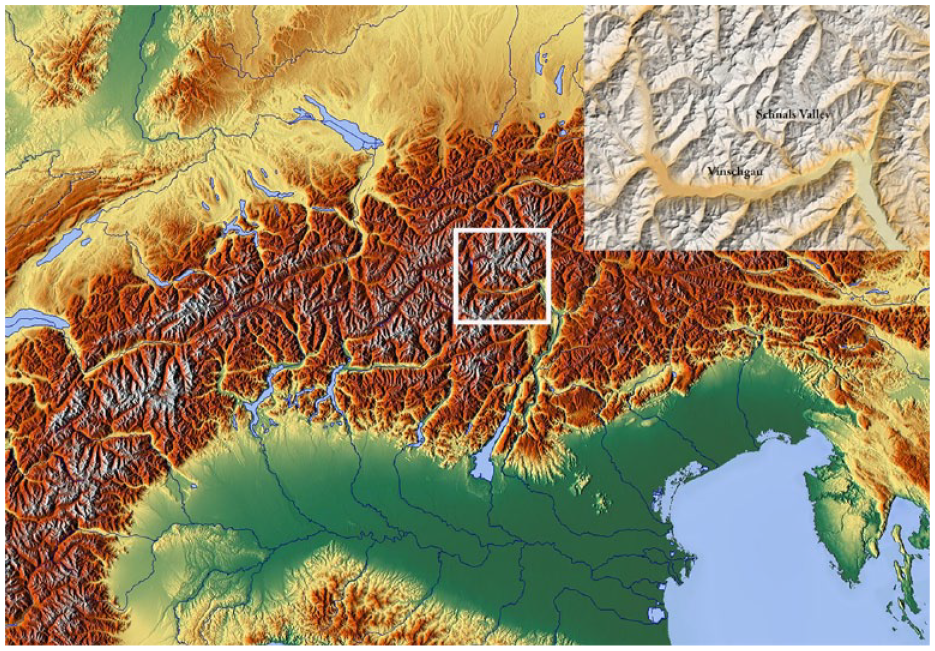
Location of the research area (License creative commons: eudem_color-shaded_3035_europe and https://maps-for-free.com/).
Cultural and urban development of the Vinschgau valley in the Bronze Age
In contrast to preceding epochs, the initial settlements in the Vinschgau region are dated to the Early Bronze Age (2200–1650 BC). These settlements predominantly situated on the orographically left side, on hilltops, in proximity to slope terraces or debris cones of the Valley floor (Figure 2). These sites, identified by thick and deep brown soils, were historically utilized as agricultural land (Fischer, 1974). The selection of easily cultivable and productive agricultural land emerges as a crucial criterion for site selection, often overshadowing considerations related to fortification purposes, as fortifications are not evidenced during this period. Due to limited excavations of Early Bronze Age settlements, insights into building culture or settlement sizes remain unavailable. However, based on the Early Bronze Age pottery assemblage, the Vinschgau exhibits cultural influence from the Polada culture (Kaufmann, 1998; Steiner, 2007), with cultural connections to the west evident through findings such as an obliquely pierced ball-headed pin from Mals (Dal Rì and Tecchiati, 1995). During the Middle Bronze Age (1650–1350/1300 BC), an expansion of the settled landscape is apparent (Figure 3), with hilltops continuing to be favored for new settlements. This expansion extends for the first time into side Valleys, such as Martell and Stilfs (Koch-Waldner, 2019), likely associated with the exploitation of existing ore deposits (Bagolini et al., 1995; Dal Rì and Tecchiati, 1995; Steiner, 2007). The smelting of local copper ores is documented at Prader Berg (Koch-Waldner et al., 2020) during the 13th–12th century BC, and metal processing is evident in various settlements across the entire Vinschgau during the Middle Bronze Age (Dal Rì and Tecchiati, 1995; Steiner, 2007). Northern cultural elements begin to exert increased influence, as observed in the pottery spectrum of the Ganglegg settlement (Steiner, 2007) or a Middle Bronze Age short sword from Schluderns (Dal Rì and Tecchiati, 1995). However, the dominance of southern cultural facies persists. The density of finds in the settlement horizons of the Middle Bronze Age indicates the emergence of three significant settlement chambers: one in the Upper Vinschgau around the Ganglegg settlement and Stilfs’ ore deposits, another in the Middle Vinschgau around Laas, possibly connected to the copper deposits of Eyrs, and a third in the Lower Vinschgau around Latsch with ties to the Martell Valley deposits. While settlement continuity on most hilltops remained uninterrupted, the population increase necessitated new agricultural land and this led to the foundation of a few new settlements on the valley floor during the Late Bronze Age (Steiner, 2007). Culturally, the entire Vinschgau Valley aligns with the Laugen-Melaun group, reflected in a uniform pottery repertoire. Foreign forms are primarily preserved in the form of metal artifacts. The expansion of the settlement area is confirmed for the entire Vinschgau and appears closely tied to copper ore deposits. The easternmost part of the Vinschgau, particularly the region around Naturns with the natural entrance to the Schnals Valley, appears neglected by the Bronze Age population of the Vinschgau. Whether this is linked to a lack of metal deposits remains to be explored.
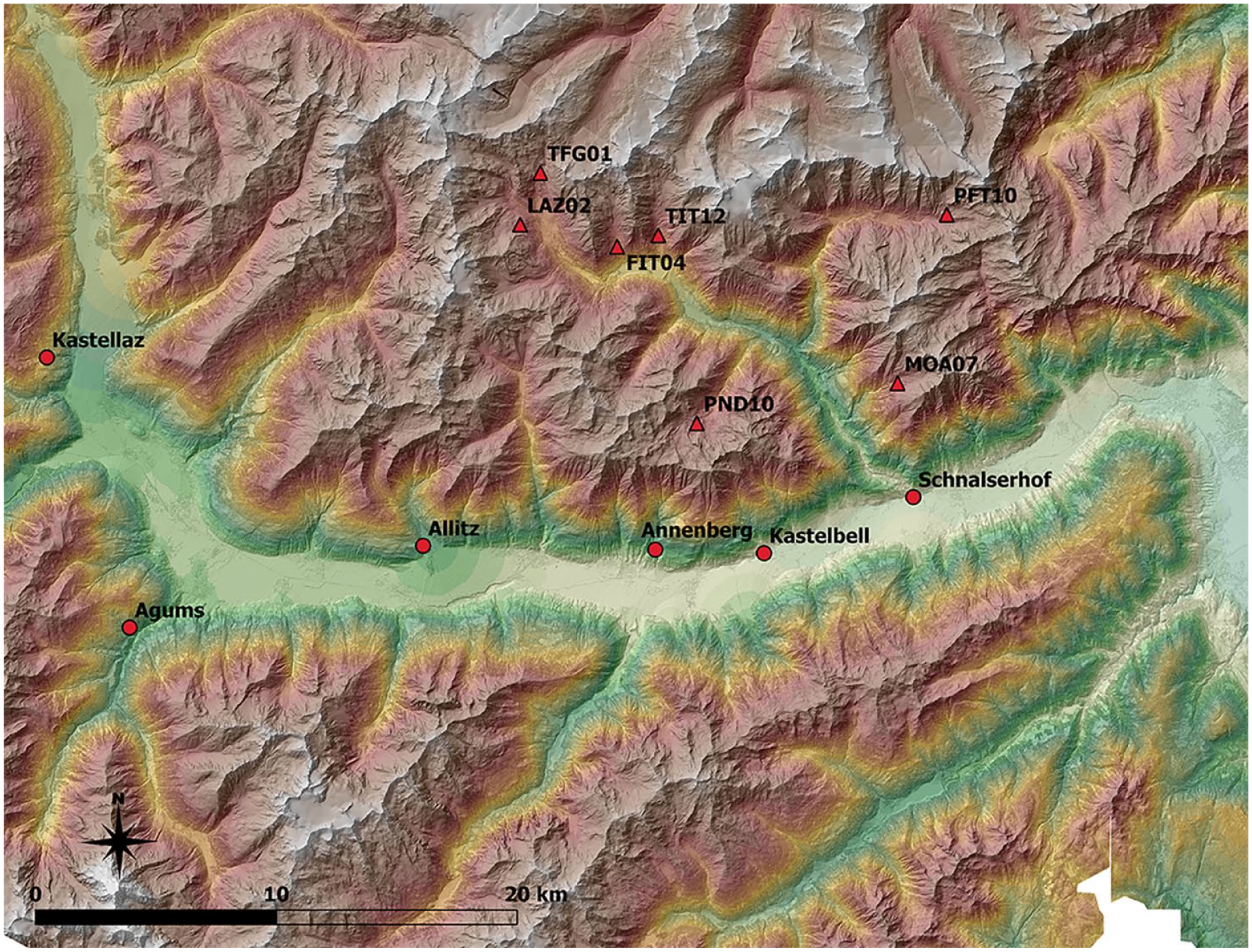
Distribution of Early Bronze Age settlements of the Vinschgau and the High Alpine Find Sites of the Schnals Valley (License creative commons: http://geoportal.buergernetz.bz.it/ and https://www.tirol.gv.at/sicherheit/geoinformation/geodaten-tiris/).
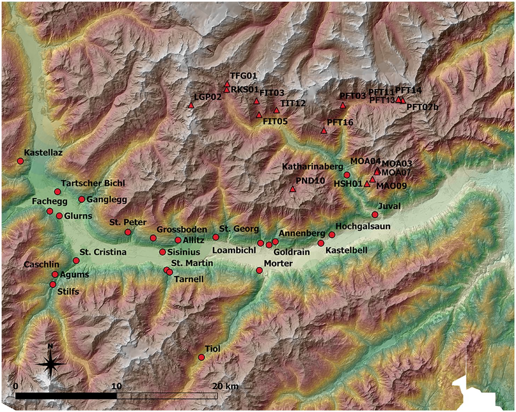
Distribution of Middle to Late Bronze Age settlements of the Vinschgau and the High Alpine Find Sites of the Schnals Valley (License creative commons: http://geoportal.buergernetz.bz.it/ and https://www.tirol.gv.at/sicherheit/geoinformation/geodaten-tiris/).
The agricultural economy of the Bronze Age in the Vinschgau Valley
The agricultural practices of the Bronze Age settlements in the Vinschgau region closely align with the subsistence economies observed in other inner-alpine areas. Predominant cereals cultivated during the Southern Alpine Bronze Age include barley (Hordeum vulgare) and broomcorn (Panicum miliaceum) (Schmidl and Oeggl, 2007). Additionally, Ganglegg reveals the significance of naked barley (Hordeum vulgare var. nudum) from the Late Bronze Age onward. Alongside cereals, fava beans (Vicia faba) and peas (Pisum sativum) played a crucial role as protein sources, with lentils being less significant in the Inner Alpine Bronze Age (Stika and Heiss, 2013). The diverse soil requirements of these cultivated plants include deep loamy soils for barley, sandy soils for millet, and no specific requirements for spelt and emmer. Fava beans and peas thrive in moist clay, peat, or humus soils. The prevalence of broomcorn in Ganglegg is attributed to the dry and warm climate of the Vinschgau Valley. Optimal arable land on Ganglegg consisted of medium-wet, nitrogen-rich soil, characteristics increasingly found on the Valley floor of Vinschgau (Schmidl and Oeggl, 2007). Evidence from Ganglegg in the Late Bronze Age indicates rotational farming, with barley and spelt serving as winter crops, while other crops were sown in spring as summer crops. Crop rotation alternates with either fallow periods or pasture use. From an agronomic perspective, proof of crop rotation is essential for effective alpine pasture management (Jacobeit, 1961). Artificial irrigation has been indispensable for agriculture in the dry Vinschgau Valley, a practice that has persisted through historical times (Fischer, 1974). A diachronic trend in the management of cattle or sheep/goats in the Alpine region is not clearly discernible from the comparison of Bronze Age settlements. While there seems to be a tendency toward an increased proportion of cattle throughout the Bronze Age, sheep and goats continue to be significant. Livestock numbers not only reflect local natural conditions but also indicate specialization in animal husbandry and/or the processing of secondary products. The faunal spectrum of animal bones in the Vinschgau Valley corresponds to the Bronze Age pattern observed in inner-alpine settlements. Variations in the Bronze Age composition of livestock herds within the Vinschgau Valley may exist due to different natural conditions. For instance, Naturns-Schnalserhof (Riedel and Tecchiati, 2000, 2002) exhibits a dominance of sheep/goats during the Early Bronze Age (65% sheep/goats, 27.3% cattle), while the settlement Ganglegg displays a more balanced distribution during the Middle Bronze Age (49.9% cattle, 38.7% sheep/goats) (Schmitzberger, 2007). The continuity of the animal spectra into the Iron Age and Roman periods, along with historical livestock populations in the middle and lower Vinschgau, suggests a diversification of domestic animals in the Vinschgau. Hunting played an insignificant role in meat supply for Early Bronze Age settlements in the Alpine region, a trend that persisted through the Bronze Age (Tecchiati, 2013). The subsistence strategy in the Vinschgau was highly adapted to the natural environmental and morphological conditions of the Valley. This strategy remained consistent even in historical times, where the agricultural economy centered on cereal and livestock farming, generating surpluses for external markets beyond the Vinschgau (Fischer, 2010; Stolz, 1924, 1930a, 1930b). The agricultural products traded primarily included wheat, rye (Schönthaler, 1992), and, in the case of livestock, oxen and sheep (Fischer, 1974), as well as processed wool in the form of loden (Ottenthal and Redlich, 1896).
Methodology
This article is devoted exclusively to archeological research, although other scientific disciplines such as botany, osteology, petrography, and food residue analysis have been included in the work. This is also intended to enhance the value of archeology, particularly in the high mountains, by providing the basis for sound scientific research on which further modeling can be based. This is necessary as the models published to date for high alpine use in the Alpine region are based almost exclusively on botanical or ethnological studies, with little convincing archeological evidence. The method to detect high alpine archeological record for this study (Putzer et al., 2016) had the focus on the discovery of archeological features associated with a possible prehistoric alpine pastoral economy, and the survey have been carried out by two people during 3 weeks in summer 2018. The methodology used was not based on the common practice detecting structures or rock shelters visible above ground, but rather on examining the whole area in small trial tranches in order to determine whether, in addition to visible sites, non-visible archeological features can be expected in the high mountains. In order to minimize the effort involved in this methodically complex and physically demanding work, soundings were mainly carried out in promising terrain, some of which is still used for grazing today. The most important criteria applied were the presence of water, level terrain, favorable exposure to the sun and protection against avalanches and rockfall. This will allow for a comprehensive survey of the area and should primarily cover all archeological features of the different time periods and including any changes in location. After the detection of the find sites, priority was given to more detailed investigation of Bronze Age sites in order to supplement the existing data set from previous years and to gain a more accurate insight into the exploration strategies of Bronze Age communities. A second aspect was to gain a better understanding of high alpine building typology, and therefore to carry out extensive excavations of at least 40 m² for high alpine archeology, as this is lacking or far from convincingly documented for the Alps. This enables a better insight into the exploring strategies and especially in the high alpine building typology of “one archeological period.”
The archeological record of the Schnals Valley
The Bronze Age record in the Schnals Valley, as discussed in this article, exclusively relies on recent research, omitting sites identified by colleagues and solely based on 14C dating (Kutschera et al., 2014) to exclude natural fire horizons (Gobet et al., 2003). While the entire Valley hasn’t been surveyed, the current dataset offers insights into the Bronze Age human impact on the Valley. The archeological findings of the Bronze Age in the Schnals Valley highlight that a significant portion of the archeological record remains hidden or covered by more recent structures. This is unsurprising given the prevalent use of timber construction in the Valley settlements of the inner Alpine region. It underscores the necessity for small-scale archeological trial trenching, supplementing the conventional survey methods based on features visible above ground or under rock shelters. Among the 20 Bronze Age sites identified, only three were visibly exposed. One site is situated under a rock shelter, now covered by a modern-age structure. All visible sites, namely TFG01, PFT7b, and FIT 04 (Figure 3), were likely situated above the timberline (between 2400 and 2600 m a.s.l.), making it challenging for the natural grass mat to cover them. It is crucial to acknowledge that only 15% of the Bronze Age archeological record in the Schnals Valley is visible. The invisibility affects all prehistoric periods in Schnals Valley, and considering that not all sites have been discovered, it is reasonable to assume a much higher level of cultural landscape intensification and emphasizes the precarious data situation regarding high alpine archeology. Despite cultural influences from the South, the architectural features, including the shape of buildings and interior elements like hearths, exhibit characteristics typical of Inner Alpine culture. A useful comparison can be made with the houses of the Ganglegg settlement (Steiner, 2007) and those in the nearby Grisons (Defuns and Gaudenz, 1988; Rageth, 1976; Wyss, 2002). The high alpine building culture of Schnals Valley aligns with that of the Trentino (Marzatico, 2007, 2009; Nicolis et al., 2016). Both high alpine regions demonstrate synchronous development in building culture in the mountains and inner alpine settlements during the Early Bronze Age, in which houses were mostly post-built, evolving into structures with foundations during the Middle to Late Bronze Age. This architectural progression is confirmed by the Bronze Age structures TFG01 (Figure 4) and PFT07b (Figure 5), affirming a continuous development of building culture in both settlements and the high alpine environment during the Bronze Age. The synchronous architectural development in the Iron Age can be inferred, as indicated by the masonry and the dimensions of the structure at Geissrüggen in the canton of Uri (Leuzinger, 2016). This pattern distinguishes Schnals Valley from other research areas in the Alps (summarized in Reitmaier, 2020; Reitmaier et al., 2021). Of particular interest are the typologically distinct hearths discovered in Schnals Valley. In addition to conventional slab hearths or open hearths (Figure 6a; Table S1), the three investigated structures feature deepened hearths lined with stone slabs (Figure 6b–d; Table S1). These hearths are consistently positioned in the middle of the hut and the comparison with hearths from inner-Alpine settlements is obvious (Defuns and Gaudenz, 1988; Rageth, 1976, 1985; Steiner, 2007; Wyss, 2002). Despite the uncertainty about the exact function of the hearths, it is reasonable to assume that they were not used for general food preparation. Instead, they likely served a special purpose, with interpretations in settlements suggesting their use as baking or roasting ovens (Wyss, 2002) or in connection with metalworking (Steiner, 2007). The Schnals Valley hearths, apart from a few burnt animal bones, lack artifacts, making it challenging to glean information about their specific use. The discovery of Swiss stone pine seeds (Pinus cembra) at Penaud implies a roasting oven function, even though roasting is not the primary function of the oven. In this context, the pine cones would need to be dried to obtain the seeds, as supported by findings from a late medieval oven for the production of secondary products (Meyer and Bitterli-Waldvogel, 1998) and subsequently for roasting in the canton of Valais. This type of oven offers better heat control, and the stone surround helps maintain a constant temperature − an essential aspect in cheese production, especially when processing large quantities of milk, ensuring consistent quality. The archeological features in the Schnals Valley, indicating annual grazing with sophisticated structures allowing for the production of secondary products, particularly ripening and storing larger quantities of cheese (Pearce, 2016), permit an archeological comparison with historical alpine farming. This contrasts with the assumption of a more primitive alpine pasture economy based on small and simple structures with mobile roofs (Fedele, 2018; Moe and Fedele, 2019; Reitmaier et al., 2021). The building culture in Schnals Valley contradicts the interpretation of mobile roofs; the dimensions of the structures (at least 60 m²) and the discovery of large stone slabs to cover the shingles, that overlay the archeological record, argue against this theory. The high alpine architecture of Schnals provides evidence that the shepherds transferred the familiar construction style of their original settlements to the high mountains instead of a group-specific architectural culture (Reitmaier et al., 2021; Walsh and Mocci, 2011). The thesis of mobile roofs is based on ethnological/historical comparisons from areas lacking necessary timber resources (Alther, 2014) and overlooks the political organization of the territory. Historical pastoralism in the Vinschgau Valley (Graß, 1948; Loose, 1976, 1999; Stolz, 1930a) and in Schnals Valley (Werner, 1969) is strictly regulated, involving a detailed political division of the territory. Both communities, smallholder and private farmers practice pastoralism. The archeological record of Schnals excludes sporadic and individual exploitation of high alpine pastures, as it has no impact on the natural landscape. Pollen diagrams from Schnals Valley suggest significant pressure on the tree line from 2000 BC onward (Festi et al., 2014), likely due to the substantial numbers of grazing animals driven into the high mountains each year. Acculturation by communities is posited as crucial for constructing sophisticated high alpine structures and providing provisions for humans and livestock during the grazing season. The notion of pasture farming solely under rock shelters, although historically proven, should be reconsidered. Historically such simple dwellings are typically based on nearby structures suitable for pasture or alpine farming (Jäger, 2011). Individuals or small landowners might struggle with the efforts involved, which is why ethnological comparison based on smallholders (Alther, 2014; Carrer et al., 2016; Reitmaier, 2020) or incommensurable economic areas (Gosselain, 2016) challenging the easy transfer of ethnological or historical practices to prehistory. It is assumed that the first “shepherds” in the pristine natural landscape did not face the same pressures as those in historical times. They likely did not build small and primitive structures in the high mountains due to a lack of building materials. Year-round use, maintenance and the storage of supplies and by-products necessitated constructions particularly suited to the high mountains, whether the milk is processed or not.
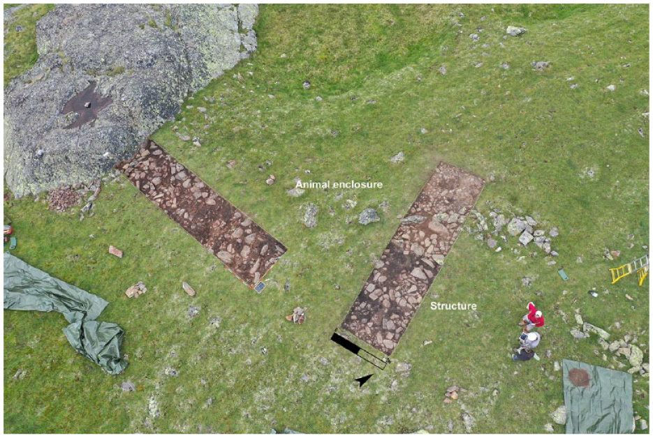
The find site TFG01 with the animal enclosure and the detected structure (picture by A. Putzer).
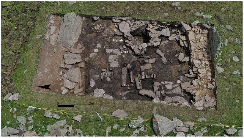
The structure PFT07b from the 14th century BC with two hearths and an attached oven (picture by A. Putzer).
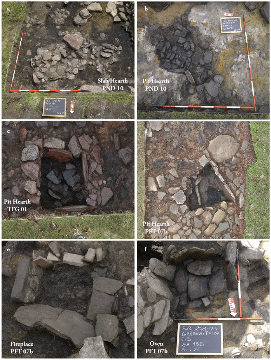
The hearths of the Bronze Age structures of Schnals Valley (picture by A. Putzer). (a) Slab Hearth of structure 2 at PND 10, approx. 17th century BC, (b) Pit Hearth of structure 1 at PND 10, approx. 17th century BC, (c) Pit Hearth in the structure at TFG 01, approx. 13th century BC, (d) Pit Hearth in the structure at PFT 07b, approx. 14th century BC, (e) Fireplace in the structure PFT 07b, approx. 14th century BC and (f) Oven in the structure PFT 07b, approx. 14th century BC.
Cultural and urban development of the Schnals Valley during the Bronze Age
From an archeological and botanical perspective (Putzer et al., 2016), the Early Bronze Age (2200–650 BC) marks the commencement of seasonal use of the natural landscape (Table S1 and S2), transforming it into a cultural landscape spanning the entire region. Human presence is not associated with sporadic visits; rather, archeological features like the sites PND10 (Putzer, 2019) and TFG01 indicate recurrent summer use. Located at altitudes exceeding 2300 m a.s.l., these sites are linked to pastoral or alpine farming. The unexcavated sites supplement the geographical distribution of human presence during the Early Bronze Age, suggesting seasonal use from Vinschgau due to the absence of settlements in the Schnals Valley during this period. The expansion of the cultivated landscape in the Middle Bronze Age on the Vinschgau Valley floor is mirrored in the high mountains of the Schnals Valley (Figure 3). This is evident in the increased number, wider distribution, and diversified archeological record of sites. The Middle Bronze Age sees the emergence of “burnt-offering sites” FIT03 and TIT12 (Putzer, 2012; Putzer and Festi, 2014), indicating a cultic occupation of the area (Rappaport, 1971) and a territorial demarcation (Bloch, 1977; Edlund, 1987; Hansen, 2003; Polignac, 1984; Putzer, 2023; Seiffert, 2006), maybe of competing communities. Besides sacrificial sites, structures related to pastoral and alpine farming are identified, by an animal enclosure from the 13th–11th centuries BC near the historic Hochjoch passage. Additionally, the highest prehistoric alpine hut in the Alps (PFT07b) is located at approximately 2600 m a.s.l. in the rearmost Pfossen Valley, dating to the 14th century BC. Occupation strategies in Schnals Valley during the Bronze Age predominantly place find sites under or close to the tree line in relation to the forest boundary of the Kauner Valley (Nicolussi, 2009a; Nicolussi et al., 2005; Figure 7). This proximity to the timberline emphasizes the importance of locating the archeological record in their foundational phase due to the importance of timber for construction and processing secondary products (Walsh and Mocci, 2011). On the other hand, the find spot TFG01 documents long-term use until the Late Iron Age (2nd–1st century BC), regardless of climate deterioration during the Hallstatt period and the associated timberline shift. In the upper part of the Pfossen Valley, a small-scale change of location within a grazing area is detected. Site PFT10 (2456 m a.s.l.) shows occupation at lower altitudes during the Early Bronze Age, a vertical shift to PFT07b (2544 a.s.l.) in the Middle Bronze Age, and a return to lower locations PFT11, PFT13, and PFT14 (2507 m a.s.l.) in the Recent and Late Bronze Age (Figure 8). As these find sites likely remained above the Bronze Age tree line (approx. 2400 m a.s.l.), a potential higher tree line for the Southern Alps may be considered (Figure 8), with human pressure on the forest boundary leading to relocation to lower altitudes. However, this reasoning does not apply to the TFG01 site, situated at 2441 m a.s.l., suggesting other factors influencing location choices. The anthracological investigations at the burnt-offering site FIT03 reveal a lowering of the forest boundary, yet the site remains active despite the increased distance to required wood resources (Edlmair, 2017). The treeline, therefore, plays a role in the founding of the find spot, while the continuity of use depends on other factors that must be justified on a case-by-case basis. In the rear Pfossen Valley, the cause seems to lie in the utilization of the passes. At the Gurgler Eisjoch, Bronze Age finds are absent (Steiner, 2015; Steiner et al., 2016), implying it wasn’t a crucial crossing during that period. It wasn’t until the end of the Bronze Age and the rising Iron Age that the Gurgler Eisjoch saw renewed use, suggesting proximity to communication routes during this period (Figure 8). The absence of Bronze Age finds from the mountain passes of the main alpine ridge may be attributed to favorable climatic conditions at the end of the 3rd millenium and, in part, during the 2nd millenium BC (Baroni and Orombelli, 1996; Nicolussi, 2009b), rendering access via steep southern slopes impossible due to permafrost thawing. This climatic shift likely influenced the abandonment of the historic transhumance route from Schnals Valley to Obergurgl over the Gurgler Eisjoch in 1963 (Fischer, 1970; Ladurner-Parthanes, 1993; Werner, 1969). Pottery findings from Schnals align with southern Alpine cultural groups like the Polada and Fiavè facies, indicating an acculturation from the south. Evidence from Katharinaberg (Bagolini et al., 1995) suggests permanent habitation in the Schnals Valley from the Middle Bronze Age (approx. 1500 BC) onward. From an agronomic perspective, permanent settlement is feasible, as demonstrated by the historical cultivation of cereals − mainly common barley and rye − (Rief, 1903) practiced up to 2100 m a.s.l. (Kirchner and Kirchner, 2007) during favorable climate periods.
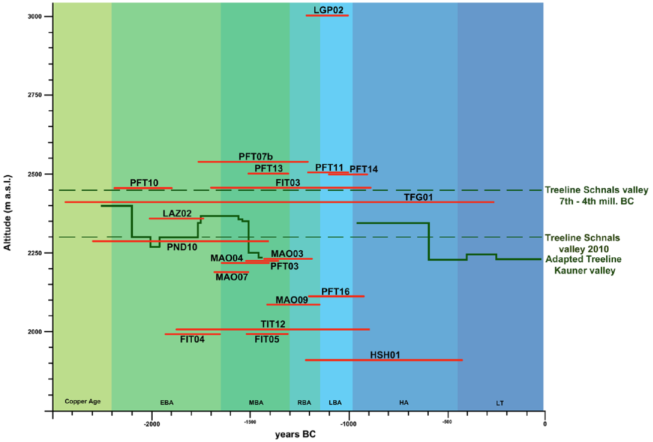
Height distribution of the Bronze Age find sites of Schnals Valley in relation to the forest boundary. Green lines: Elevation of the Treelines of the Schnals Valley; Red Lines: Time horizon of the detected find sites (Adapted treeline Kauner Valley after Nicolussi et al., 2005, Kauner Valley after Nicolussi, 2009a; Tree line 7th–4th mill. BC after: Staffler et al., 2011; Treeline today after: Hintner, 2010) (Grafic by A. Putzer).
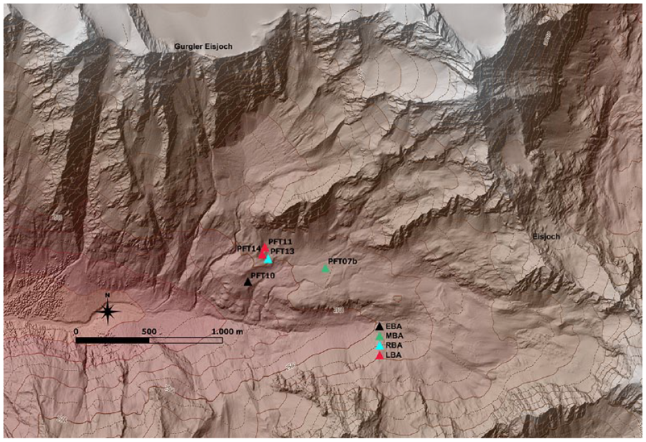
Vertical shift of find sites at Pfossen Valley (License creative commons: http://geoportal.buergernetz.bz.it/ and https://www.tirol.gv.at/sicherheit/geoinformation/geodaten-tiris/).
General discussion
The cultivation of the Schnals Valley during the Early Bronze Age was not a result of haphazard individual or small-group efforts; instead, the presence and simultaneous archeological evidence across the entire Valley indicate a purposeful and organized development of the region. The discovery of a globe-headed pin at PND10, suggests that the group or groups were integrated into the social fabric of the Vinschgau Valley. This finding confirms the involvement of a higher social stratum and points to an organized acculturation of the natural environment, rather than individual-based occupation (Butters et al., 1996). Another noteworthy aspect revealed by the results from the Schnals Valley is that the secular use of the high alpine landscape predates the sacred occupation of the area, starting from the Early Bronze Age, while the burnt-offering sites only emerge in the Middle Bronze Age. The burnt-offering sites, however, indicate a ritual and territorial demarcation through their supra-regional finds, such as amber and glass beads at site FIT03 (Putzer, 2012) or a dagger with a trapezoidal handle plate at the offering site TIT12 (Putzer and Festi, 2014). The deposition of these exceptional finds differs from the burnt-offering site Hahnehütterbödele near the settlement Ganglegg (Steiner, 2007), where archeological finds appear to consolidate the social structure of the local community and exclude the deposition of foreign goods, even if found in the settlement. This can be interpreted in terms of trade routes over mountain passes for the Schnals Valley (Marzatico, 2014, 2019, 2022). However, Bronze Age artifacts from the Tisen Pass are still missing, and the Final Pass was not a historical route, as it was first mentioned in connection with the emerging alpinism in the 19th century (Hess, 1894). This contrasts with the documented historical passes of the Schnals Valley, which, with the exception of the Hochjoch – now a ski region and altered by encroachments on the natural landscape – were used in Prehistory. In any case, the supra-regional finds in the high alpine sacrificial sites and structures of the Schnals Valley underscore that communities had the necessary economic resources to deposit prestigious objects, and the cultivation of the natural environment was carried out under the leadership of privileged social classes. It is imperative to elucidate the motivating factors that prompted the settlers from the Vinschgau Valley to colonize this high alpine Valley, which was geographically isolated from the Vinschgau settlement area. The absence of ore deposits necessitates consideration of alternative reasons for cultivation. While the extraction of raw materials, a frequently cited factor in the literature and demonstrated in the Early Bronze Age in other research areas in the Eastern Alps (Stöllner, 2010, 2012), could have driven exploration in Schnals Valley, it fails to account for the establishment of structures in the Early Bronze Age despite the lack of raw materials. The continuity and distribution of Copper Age sites in Schnals Valley during the 3rd millenium BC, also imply prior exploration of the region. What societal and/or economic changes occurred in the Vinschgau Valley during the Early Bronze Age? Did mining activities commence earlier in the Vinschgau region? Hunting as a primary impetus can be discounted, as game did not hold significant importance in the subsistence economy of Bronze Age settlements in the Vinschgau. Can the transformation of the cultural landscape in Schnals Valley be solely explained by the utilization of natural resources such as wood, water, and pasture land? However, it is unnecessary to limit the utilization of the Valley to any one of these reasons; rather, it must be posited that all available resources were economically exploited. Forestry practices of the Vinschgau settlers encompassed the subalpine and alpine zones (⩾1800 m a.s.l.), as evidenced by building elements constructed from Swiss stone pine (Pinus cembra) in the Ganglegg settlement (Oberhuber and Swidrak, 2007). Additionally, the gathering of Swiss stone pine cores has been substantiated at site PND 10 (Edlmair, 2017). The significance of water in the arid Vinschgau Valley has been previously emphasized, suggesting that the water resources of Schnals Valley, along with those of other adjacent Valleys, were likely utilized. The topography, characterized by steep terrain, implies that fields were situated on sloping terraces near settlements or on the alluvial cones of the Vinschgau Valley floor, partially ruling out irrigation from the Adige River. Consequently, irrigation of the fields depended on tributaries of the Adige River, facilitated by irrigation ditches historically documented in the Vinschgau Valley since the 13th century AD (Huter, 1955), with essential roles in cereal cultivation in earlier periods. The archeological reclamation of the research area occurred between the 20th and 15th centuries BC (EBA 2−MBA 2), as supported by botanical analyses (Festi et al., 2014). In the Recent and Late Bronze Age, there is a paucity of new archeological features, and human presence is documented through the continued use of existing archeological elements. This underscores that high alpine utilization is not tied to the burgeoning metal processing in the Vinschgau, reaching its zenith only in the Recent Bronze Age. Consequently, the cause-and-effect relationship proposed by (Maggi, 2004; Pearce and De Guio, 1999; Reitmaier, 2020) wherein mining/metal processing favored pastoralism, does not hold. While it cannot be ruled out that Schnals Valley contributors played a role in regional power dynamics by supplying wood/charcoal and agricultural products (Harding, 2013; Shennan, 1995), this presupposes a central power or chiefdom society (Earle, 2011), supported by limited archeological evidence during the Early and Middle Bronze Age in the Vinschgau. An exception is the Ganglegg settlement (Marzatico, 2022; Steiner, 2007), exhibiting findings suggesting the presence of an elite social class by the end of the Middle Bronze Age (14th century BC). The construction of a massive fortification and the settlement’s expansion to seven hectares in the Late Bronze Age (Faller et al., 2021; Gietl et al., 2021; Steiner, 2007) further indicate characteristics comparable to emerging Terramare culture settlements (Cardarelli, 2009). That the communities of the Lower Vinschgau were not isolated from large-scale trade in the Early- and Middle Bronze Age and later on as intermediaries between the Terramare culture to the south, and the emerging Urnfield culture to the north (Kristiansen and Suchowska-Ducke, 2015) is supported by items such as button-shaped amber beads from Central Europe (Woltermann, 2016) and HMBG glass beads typical of the Terramare culture (Bellintani, 2014, 2018; Bellintani et al., 2006). It can be discounted that the Schnals Valley passes played a pivotal role in this interregional trade, as the seasonal limitations for crossing the alpine ridge create a discontinuity in the flow of goods. However, the utilization of the passes for communication or small-scale trade is evident from the concentration of Bronze Age sites below the Ginggl and Eisjoch (Figure 3) and the findings from the Langgrubenjoch (Steiner, 2015). Possibly the patchy archeological record, reflected in the scarcity of Early Bronze Age prestige finds from the Vinschgau Valley, likely obscures the emergence of metallurgy. Changes in agricultural practices are also unlikely as the composition of flocks remains virtually unchanged, dominated by sheep and goats. In the Early Bronze Age, an elite social class appears to have emerged in the Vinschgau Valley, promoting the cultivation of high alpine side Valleys to ensure food supply for settlements or a chief clan. This model, proposed by Earle (1997) and adopted by Kristiansen (2010) for Jutland, suggests that local chieftains supported the establishment of new settlement space and provided livestock in exchange for services or natural goods. In the inner Alpine region, this corresponds to the function of the “Schwaighöfe” founded in the 12th–13th century AD. These were provided by the noble families with the so-called “iron cattle,” tied to the farm, in return for payments in the form of natural resources and services. The “Schwaighöfe” in the 12th–13th century AD at the Schnals Valley (Scharr, 2001), were mainly founded by the noble family of Montalban. In addition to the duties to be paid, they secured inner-alpine communication routes and served as accommodation for travelers. Future research will hopefully confirm or refute the validity of this model as an explanation for the cultivation of high alpine side Valleys. In any case, for the Schnals Valley, it would represent a repetition of the cultural history of the Valley.
Conclusion
Research in the Schnals Valley indicates that the development of the peripheral landscape is linked to internationally sought-after commodities during the Bronze Age (Earle et al., 2015) and the emergence of “cultural players” north and south of the Alps (Cardarelli, 2009; Kristiansen and Suowska-Ducke, 2015). The regional resources (Earle et al., 2015) of local communities were based on animal herding at high alpine pastures, maximizing agriculture, and controlling one of the most important transit routes across the Alps through the Vinschgau Valley. This suggests that the development of the high alpine region was primarily driven by economic reasons (Steiner, 2010), fueled by intensified contacts between Bronze Age cultural groups in Europe. The production of additional products such as timber, livestock, wool, cheese, and cereals from the Alpine side Valleys strengthened the economic position of local cultural groups, securing them a more active role in the long-distance trade of goods, even in this peripheral high alpine Valley, which is part of the emerging political economy during the Bronze Age (Earle et al., 2015). Chronologically, the use of the Schnals Valley predates the emergence of social elite classes in the region, archeologically documented in the Recent Bronze Age and linked to extensive mining and metal artifact production.
Supplemental Material
sj-docx-1-hol-10.1177_09596836241254482 – Supplemental material for Mapping a peripheral landscape: The Bronze Age transformation at Schnals Valley (South Tyrol/Italy)
Supplemental material, sj-docx-1-hol-10.1177_09596836241254482 for Mapping a peripheral landscape: The Bronze Age transformation at Schnals Valley (South Tyrol/Italy) by Andreas Putzer in The Holocene
Supplemental Material
sj-docx-3-hol-10.1177_09596836241254482 – Supplemental material for Mapping a peripheral landscape: The Bronze Age transformation at Schnals Valley (South Tyrol/Italy)
Supplemental material, sj-docx-3-hol-10.1177_09596836241254482 for Mapping a peripheral landscape: The Bronze Age transformation at Schnals Valley (South Tyrol/Italy) by Andreas Putzer in The Holocene
Supplemental Material
sj-tif-2-hol-10.1177_09596836241254482 – Supplemental material for Mapping a peripheral landscape: The Bronze Age transformation at Schnals Valley (South Tyrol/Italy)
Supplemental material, sj-tif-2-hol-10.1177_09596836241254482 for Mapping a peripheral landscape: The Bronze Age transformation at Schnals Valley (South Tyrol/Italy) by Andreas Putzer in The Holocene
Footnotes
Acknowledgements
This work is dedicated to all my collaborators Tobias Mores, Andreas Vigl, William D’Alessandro, Lukas Zangerle, Nico Aldegani and Andrea Zadra who, through their dedication and enthusiasm during the fieldwork, have made a significant contribution to the production of this archeological dataset. I would like to thank my colleagues Hubert Steiner and Catrin Marzoli from the Archeological Office of the Province of Bolzano for their administrative support.
Author contributions
Declaration of conflicting interests
The author declared no potential conflicts of interest with respect to the research, authorship, and/or publication of this article.
Funding
The author disclosed receipt of the following financial support for the research, authorship, and/or publication of this article: This work was supported by the Austrian Science Fund (grant no.: P21129-G19, “The Neolithic Agricultural Regime in the Inner Alps,” 2009–2012); the South Tyrolean Science Fund (grant no.: B35E12000330003, “Prähistorische Besiedlung und Ökonomie inneralpiner Hochtäler im Falle des Schnalstals (Südtirol/Italien),” 2014–2017); the South Tyrolean State Museums Science Fund (grant no.: H36C18000180005, “Schnals – Das Hochgebirge als Wirtschafts- und Interaktionsraum prähistorischer Dorfgemeinschaften”, 2018–2021).

Supplemental material
Supplemental material for this article is available online.
References
Supplementary Material
Please find the following supplemental material available below.
For Open Access articles published under a Creative Commons License, all supplemental material carries the same license as the article it is associated with.
For non-Open Access articles published, all supplemental material carries a non-exclusive license, and permission requests for re-use of supplemental material or any part of supplemental material shall be sent directly to the copyright owner as specified in the copyright notice associated with the article.
