



Abstract
Rockfall represents one of the most destructive geomorphic processes for infrastructure and settlements located at the foot of mountain slopes. Furthermore, it poses a hazard for visitors and hikers. Despite the high anthropic activity in these environments, research on the reconstruction of rockfall in the high mountains of Mexico is still scarce. We used dendrochronological, dendrogeomorphological and lichenometric approaches to study the age and rockfall dynamics in a talus slope in central Mexico. Tree- ring chronologies were constructed from 140 samples of 50 Pinus hartwegii trees, 10 Juniperus monticola shrubs and 16 Ribes ciliatum shrubs to determine the age, frequency and rockfall stability at the upper limit of the forest (~4000 m a.s.l.). 52% of the tree samples showed impact scars, 39% callus tissue, 7% growth suppression and 2% corresponded to trees killed by rockfall. The frequency of rockfalls has increased since the second half of the 20th century, with the 1990s being the period of greatest activity. The years with the greatest disturbance were 1991, 1994 and 1998, possibly due to the intense rainfall that accumulated during the summer, as well as the earthquakes recorded in central and southern Mexico with magnitudes ⩾6. For the lichenometric analysis, 231 thalli of Rhizocarpon geographicum were measured in an active rockfall area. The results suggested three areas of rockfall activity. In the first area the ages were from 61 (±5 year) to 322 years (±41 year). In the second area, the ages were from 12 (±3 year) to 50 years (±12 year). The third area corresponds to an active zone with lichen-free blocks, located near the escarpment. The combination of dendrochronological and lichenometric methods allows a better determination of the minimum ages of rockfall, frequency, spatial distribution, and their possible factor triggers.
Introduction
The world’s mountainous regions are experiencing increased biophysical change, driven by human pressures through altering natural landscape conditions (Walker and Shiels, 2013), as well as climate variability (Pepin et al., 2015; Rangwala and Miller, 2012; Thompson et al., 2011), earthquakes (Marzorati et al., 2002) and volcanic activities (Pierson and Major, 2014). These facts have led to an increase in geomorphological dynamics through phenomena such as soil erosion, landslides, lahars, rockfalls (Allen and Huggel, 2013; Imaizumi et al., 2020).
Mountain slopes in periglacial and alpine environments, which are subject to both physical weathering and gravitational and erosional processes, are particularly dynamic, leading to episodic accumulation of detritus at the base of slopes (Davies et al., 2001; Luckman, 2013; Sass, 2006). The supply of materials is conditioned by factors such as slope lithology, structure, and morphology, as well as changes in land use (Lopez-Saez et al., 2016). Triggering events can be related to thermal stress on rocks, freeze-thaw cycles, precipitation, wind, and pressure release from glacial retreat (Imaizumi et al., 2020; Luckman, 2013). Earthquake activity is another triggering phenomenon (Marzorati et al., 2002), such that tectonic movements of M ⩾ 5.5 can cause rockfall (Rodriguez et al., 1999), with slope susceptibility depending on the presence of faults or fractures. The earthquake event may only increase the slope’s susceptibility to rockfall, which is later triggered by other processes such as physical weathering or rainfall (Massey et al., 2022). The mechanism of movement can be by free fall in the case of vertical walls, by saltation on slopes with slopes greater than 45°, and by rolling when the angle is less than 45° (Evans and Hungr, 1993; Gutiérrez-Elorza, 2008). This results in lobes of rockfall with predominant slopes between 32° and 40° (Luckman, 2013).
The dynamics of material from rockfall on slopes has been studied using methods such as sediment traps to understand the relationship between the amount of deposited material and some parameters such as lithology and slope structure (Krautblatter and Moser, 2009; Vehling et al., 2016). High-resolution photogrammetry has been used to detect spatiotemporal changes in rockfall-susceptible walls (Kromer et al., 2019), and geophysical methods have been used to study the composition and internal structure of slopes with the aim of understanding the processes that led to their formation (Sass, 2006; Senderak et al., 2017). The analysis of the geomorphological dynamics of slopes using dendrochronological methods can provide spatio-temporal information with annual or sub-annual precision over a span of decades and even up to hundreds of years ago (Pierson, 2007; Stoffel et al., 2024; Trappmann et al., 2013). To this end, tree-ring perturbations have been used to reconstruct rockfalls over decades or centuries (Stoffel et al., 2005) and their frequencies (Moya et al., 2010). More recently, other topics have been addressed, such as the determination of rockfall impact probabilities using coniferous trees in an alpine environment in Europe (Mainieri et al., 2020). In the volcanic environments of central Mexico, Stoffel et al. (2011) and Franco-Ramos et al. (2017a) have addressed the reconstruction of rockfall using conifers that form the timberline located at around 4000 m a.s.l.
The analysis of geomorphic stability associated with the minimum age of the landform (Stoffel and Bollschweiler, 2008) has also been carried out in periglacial and alpine environments on both sides of the equator through the dating of trees and their relationship with colonization episodes on moraine deposits (Koch, 2009), or for the analysis of hydro-volcanic processes such as lahars and floods in middle latitudes (Pierson, 2007). In low-latitude volcanic environments, the stability of ravines has been studied based on the age of trees (Franco-Ramos et al., 2017b), as well as the analysis of tree colonization following pyroclastic flow events (Franco-Ramos et al., 2019), in addition to the dating of lava flows (minimum ages) based on the age of high mountain shrubs (Alcalá-Reygosa et al., 2018).
Lichenometry has been also used to date different landforms (Beschel, 1961). This method is based on determining the growth rate on surfaces of known age, such as cemetery gravestones, or using historical archives such as panoramic and aerial photographs. Dendrochronology or tephrochronology can also be used to calibrate the age of lichens (Solomina and Calkin, 2003; Wiles et al., 2010). To determine the minimum age of landforms and to study geomorphic dynamics (Winchester and Chaujar, 2002), once the growth rate is obtained from the model fit line, the age of other lichen populations growing in nearby locations and under similar environmental conditions can be estimated (Benedict, 2009; Innes, 1983).
Previous work in lichenometry has investigated glacier dynamics in subpolar (Bradwell, 2004; Calkin and Ellis, 1980; Solomina and Calkin, 2003) and alpine (Beschel, 1973; Garibotti and Villalba, 2009; Winchester and Harrison, 2000) settings. Other studies in middle latitudes include debris flows (Innes, 1983; Winchester and Chaujar, 2002), avalanches (McCarroll, 1993), river dynamics (Gob et al., 2008) and rockfalls (Graber and Santi, 2022). Regarding intertropical volcanic environments, the lichenometric method has been used for dating lava flows on the Pico de Orizaba volcano (Alcalá-Reygosa et al., 2018).
The study of landform instability in the volcanic slopes of central Mexico using dendrochronological and lichenometric approaches is relevant because it helps to understand the processes and factors that have influenced their distribution and frequency, with a window of analysis of tens to hundreds of years. In addition, they allow us to reconstruct events in places where there is no instrumental record of these phenomena, which could represent a socio-economic threat. In this context, our hypothesis is that there is a similarity in the spatial distribution pattern of the ages of trees and/or shrubs with the ages of lichens due to geomorphological instability on the talus slopes. The aims of this study are: (i) to evaluate the dendrochronological and dendrogeomorphological potential of trees and shrubs in a talus slope of high volcanic mountains; (ii) to reconstruct rockfall events on a talus slope and to analyze their return periods; and (iii) to estimate the minimum age of the talus slope colonized by trees (Pinus hartwegii), shrubs (Juniperus monticola and Ribes ciliatum) and lichens (Rhizocarpon geographicum).
Study area
Iztaccíhuatl is a volcanic complex located in the Sierra Nevada (SN) in central Mexico, within the Trans-Mexican Volcanic Belt (CVTM), a magmatic arc that crosses the country from west to east between parallels 19° and 21° N latitude (Andrés et al., 2010) and is the result of the subduction of the Cocos and Rivera plates below the continental plate, generating seismic and volcanic activity in the central and southern region of the country (Ferrari, 2000) (Figure 1a). The volcano is located on the eastern margin of the valley of Mexico (Figure 1b) and was shaped by glacial activity, hydro-volcanic, fluvial and mass movement processes (Figure 1c).
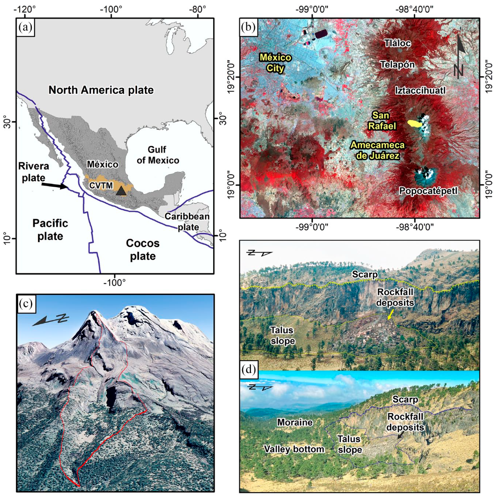
Location map of the study area. (a) Regional geo-tectonic context and the Trans-Mexican Volcanic Belt (TMVB). (b) The Sierra Nevada is formed by Iztaccíhuatl and Popocatépetl volcanoes. The yellow polygon shows Valle del Silencio (study area). (c) 3D view from Google Earth shows the North-western slope of Iztaccíhuatl where Valle del Silencio is located, a glacial valley with a U-shaped morphology, flat bottom and moraines dated between 21 ka and 8 ka. (d) Comparative views of the talus slope and recent rockfall deposits on the northern slope of the Valle del Silencio. The upper view is from 27 May 1997. The lower view is from 26 January 2023.
Iztaccíhuatl is the result of the emplacement of lavas of dacitic to andesitic composition with ages between 0.9 and 0.08 Ma and (Arce et al., 2019; Nixon, 1989), located on a system of N-S lineaments (Johnson and Harrison, 1990). The volcano is composed of lava flows and domes intercalated with pyroclastic flow deposits in its summit parts, and pyroclastic and epiclastic deposits in its lower parts (Arce et al., 2019). The moraines are the product of glacial activity which took place between the Mid Pleistocene and the Holocene (Vázquez-Selem and Heine, 2011). Geomorphological dynamics are driven by hydrovolcanic and fluvial processes (Prado-Lallande, 2017; Schneider et al., 2008) as well as gravitational processes, that is, rockfall (Stoffel at al., 2011).
The Valle del Silencio is a glacial valley located on the NW slope of the volcano. It is flanked by thick lava flows of the Summit Series (< 0.6 Ma) (Nixon, 1989) underlying moraines dated between the late Pleistocene (21 ka) and early Holocene (8 ka) (Vázquez-Selem and Heine, 2011). The valley floor is formed by moraine and fluvial deposits covered by ashes of Popocatépetl volcano from the Mid-Holocene (Arana-Salinas et al., 2010). On the northern slope of the valley between 4000 and 3850 m a.s.l. there is a talus slope with an area of ~6.6 ha, colonized by Pinus hartwegii, the tree species that forms the upper forest belt in central Mexico, as well as alpine grassland. The predominant inclinations of the talus slope are 25–40° on the upper and middle parts and 10–25° in the lower parts. In the easternmost portion of the talus, around 3950 m a.s.l., there is a recent rockfall deposit that covers 11,667 m2 or 18% of the talus slope surface, with an open vegetation of Pinus hartwegii trees and grasses dispersed between blocks, along with scattered alpine shrubs Juniperus monticola and Ribes ciliatum, with mosses and lichens (Rhizocarpon geographicum, among others) colonizing the block surfaces. The upper part of this slope consists of a rock wall with an average height of 70 m and slopes between 50° and 86° (Figure 1d).
Regarding the climatic conditions, the Altzomoni weather station, located southwest of the Iztaccíhuatl volcano at 3985 m a.s.l. (RUOA-UNAM, 2023), records a summer rainfall regime due to the displacement of the intertropical convergence zone towards the Northern Hemisphere, while the annual temperature oscillation is low due to the altitude of central Mexico (Andrés et al., 2010). The annual mean precipitation is 820 mm; however, 653 mm of rainfall (80% of the total) occurs between May and September, with June being the rainiest month at 150.1 mm. The annual mean temperature is 5.1°C, with a maximum of 6.3°C in May and a minimum of 2.8°C in January (RUOA-UNAM, 2023).
Materials and methods
Fieldwork
Dendrochronological sampling for reference and for the reconstruction of rockfall events
In the first stage of field work we collected 20 samples from 10 individuals of Pinus hartwegii trees outside of the talus slope, without no apparent geomorphological disturbance, with the aim of constructing a reference growth curve. Subsequent sampling on the talus slope itself consisted of a random collection along a SE-NW direction. A total of 110 samples were collected from 49 trees, of which 101 were increment cores collected with a Pressler increment borer (Figure 2a), and 9 were wedges obtained with an electric chainsaw, following the methodological criteria outlined in Bräker (2002). During fieldwork, samples were collected from trees with visible wood damage due to rockfall (Stoffel and Bollschweiler, 2008), but samples were also taken from trees in areas susceptible to rockfall without apparent bark damage. We applied this approach because it has been demonstrated that conifers have a good ability to close their wounds (Stoffel and Perret, 2006), thus avoiding underestimating the number of older events on the slope.

Geomorphic conditions of the study site and field sampling strategy. (a) P. hartwegii tree with evidence of rockfall impact, sampled with an increment borer, drilled near the scar. (b) Juniperus monticola shrub growing on the rockfall deposit. (c) Ribes ciliatum shrub colonizing the rockfall deposit. (d) Thalli of Rhizocarpon geographicum growing on a rock block within the rockfall deposit.
Sampling for minimum age on talus slope and recent rockfall lobes
From the total number of increment cores (101 samples), the longest-lived Pinus hartwegii trees, 49 increment cores (equivalent to the 49 trees sampled) were used to analyze the minimum landform ages. The drilling was done at breast height, aiming at the pith, with the objective of determining the absolute age of each tree and generating a minimum age map of the geomorphic surfaces. For Juniperus monticola, six cross sections (Figure 2b) were collected from dead individuals; also, the maximum diameter of three living individuals was measured to estimate their age using the diameter-growth equation generated at similar elevation in the SW of Iztaccíhuatl by Garduño-Cuevas (2017). We also collected 11 Ribes ciliatum samples (Figure 2c) prioritizing long-lived appearing individuals to determine minimum ages of colonization on the rockfall deposit.
Sampling for minimum age based on lichenometry
The thalli of Rhizocarpon geographicum lichens were measured on blocks of the rockfall deposit (Figure 2d). This species has good adaptability and resilience to diverse climatic conditions, as well as centennial or millennial longevity and predictable growth (circular morphology), which makes it suitable for geomorphological reconstruction studies (Benedict, 2009). Fieldwork was conducted on various rock blocks along transects with southeast-northwest direction on a rockfall deposit on the talus slope of Valle del Silencio. Blocks with dimensions of ⩾1 m in length were selected due to their greater stability for preserving lichen populations (Graber and Santi, 2022), and preferably with the rock face oriented towards the south, southeast, and southwest due to their longer periods of illumination (Armstrong and Bradwell, 2010). Additionally, we ensured that the blocks were of the same rock type (andesite). In most cases, we were able to measure the major axis of the 10 largest lichens on each rock block, while in others, it was only possible to measure the major axis of the four or five largest lichens per block. This selection process was guided by certain criteria recommended by Beschel (1961), Calkin and Ellis (1980), Innes (1985), and O’Neal (2006). This methodology included: (a) selecting thalli with circular and/or semicircular shapes, and (b) avoiding the measurement of thalli with anomalous morphologies and coalescences.
Laboratory preparation and analysis
In the laboratory, the wood samples were prepared (mounted and sanded) and the growth rings counted and dated to the exact year of their formation based on standardized dendrochronological techniques proposed by Bräker (2002), discarding the samples that presented growth problems. A stereomicroscope and a VELMEX measuring system consisting of a micrometer and sliding phase stage were used. The visual and statistical correlation analysis between samples was performed in the TSAP-Win software™ (Rinn, 2003), while the inter-correlation and sensitivity of the series was evaluated with the COFECHA software (Holmes, 1983). For the generation of a standardized chronology and to obtain the Ring Width Index (RWI), we used the dplR package in the R-Studio environment (R Core Team, 2023). The identification of impact events attributed to rockfall was based on clear identification (appearance) and dating of growth disturbances in wood samples such as scars, callus tissue, and growth suppressions proposed by various authors (Stoffel and Bollschweiler, 2008; Stoffel and Corona, 2014; Stoffel et al., 2005).
In the case of lichens, a database was generated with measurements of the major axis of the largest lichens (257 measurements) per rock block (26 rock blocks), and subsequently, the largest lichen per block was discarded as a rule to avoid overestimation (assuming that the largest lichen survived the block fall) (Graber and Santi, 2022; Rosenwinkel et al., 2015), leaving 231 lichen measurements for analysis. The estimation of lichen ages for this study was based on the growth rate reported by Palacios et al. (2012) in the Ayoloco Valley, approximately 3 km south of our study site. This reference curve was constructed based on the use of aerial and panoramic photographs from 1897 to 2000 and measurements of Rhizocarpon geographicum thalli in glacial deposits from the Little Ice Age obtaining an average value of 0.23 mm/y.
The maximum average ages were calculated for each rock block with the aim of better representing the distribution of ages (Jomeli et al., 2007; McCarroll, 1993). In addition, the X, Y, and Z positions of the rock blocks were visually adjusted based on the orthomosaic, geomorphological schemes and photographs taken in the field. The interpolation method used was Ordinary Kriging in ArcGis v.10.7 software, considering the data distribution and trend, in order to reduce estimation errors. For the interpolation of tree ages, the age of all samples was calibrated considering the missing rings to the pith and the annual height of growth according to Torres-Beltrán (2013). Rockfall events were compared with maximum rainfall events recorded within 24 h, along with the accumulated rainfall from the previous 3 days, in order to discriminate information and select rainfall events with the potential for rockfall generation (Delonca et al., 2014; Leyva et al., 2022). Meteorological data were downloaded from the National Meteorological Service (CNA-SMN, 2023), using three stations: San Rafael (code 15106), Tlalmanalco (code 15280), and San Pedro Nexapa (code 15103), due to their proximity to the study area and because some stations have gaps in the data. Information on rockfall events was also associated with seismic events that affected the central and southern regions of the country with magnitude ⩾ 6 (Rodriguez et al., 1999).
Results
Dendrochronological potential
The reference curve was constructed with 14 samples of Pinus hartwegii (discarding six due to growth problems) obtaining a chronology of 212 years (1810–2021), with an intercorrelation validated in the COFECHA program of 0.54 p < 0.01, and a mean sensitivity of 0.33 p < 0.01 (Figure 3a). While for Juniperus monticola, a 342-year growth curve was obtained with six samples, as well as a COFECHA intercorrelation of 0.36 p < 0.01, and a mean sensitivity of 0.35 p < 0.01 (Figure 3b). Pearson’s correlation coefficient between these two species was 0.15 p < 0.01. The chronology of Ribes ciliatum was constructed with 12 wood samples. The data showed an extension of 59 years and a COFECHA intercorrelation of 0.56 p < 0.01, and mean sensitivity of 0.33 p < 0.01 (Holmes, 1983) (Figure 3c). The species exhibited some dating problems such as growth suppression in some sectors of the samples and missing rings. The correlation matrix between the Ring Width Index (RWI) of the species and the monthly rainfall and temperature data from the meteorological station located southwest of the Iztaccíhuatl volcano (3985 m a.s.l.) revealed a positive trend between the growth of Pinus hartwegii and the monthly summer rainfall. However, the most significant correlation occurred in October (r = 0.76, p < 0.05). In the case of Juniperus monticola, a positive trend was found with the temperatures at the beginning of spring and early summer, but a high relationship was obtained with the month of November of the previous year (r = 0.81, p < 0.01). For Ribes ciliatum, a positive trend was observed with the monthly summer rainfall, but the highest correlation was obtained in September (r = 0.61, p < 0.01).

Tree ring chronologies generated for Valle del Silencio. The Ring Width Index (RWI) is depicted (gray line) with a mean of 1.0 and homogeneous variance. A 10-year spline curve was applied to highlight periods of higher and lower growth (black line). (a) RWI of Pinus hartwegii. (b) RWI of Juniperus monticola. (c) RWI of Ribes ciliatum.
Disturbances in the tree rings of trees and shrubs due to rockfalls
On the talus slope of Valle del Silencio, a total of 83 disturbances were identified in the tree rings due to rockfall. Of these, 43 are scars (52%), 32 callus tissues (39%), and 6 growth suppression (7%). In addition, the year of death of two individuals (2%) due to rockfall impact was determined (Table 1). In most of the impact-scarred samples of Pinus hartwegii, chaotic cell tissue formation (callus) and some growth suppressions were observed, especially after impacts (Figure 4a). While Ribes ciliatum showed two impact scars in the years 2013 and 2020, as well as slight calluses (Figure 4b). Spatially, the highest concentration of affected trees occurred on the western end of the slope with 14 trees (P. hartwegii) and a range of impacts between 1 and 9. The central zone of the slope presented a greater dispersion with five affected trees and a range of impacts from 1 to 3 per tree (Figure 4c), associated with the retreat of the wall due to rockfalls. On the southeast end of the talus slope, covered with recent-looking boulders, two well-preserved dead wood trunks were found.
Growth disturbances related to rockfall on the talus slope of Valle del Silencio.
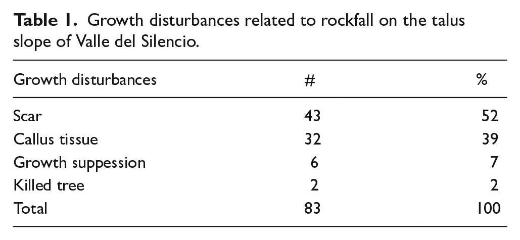
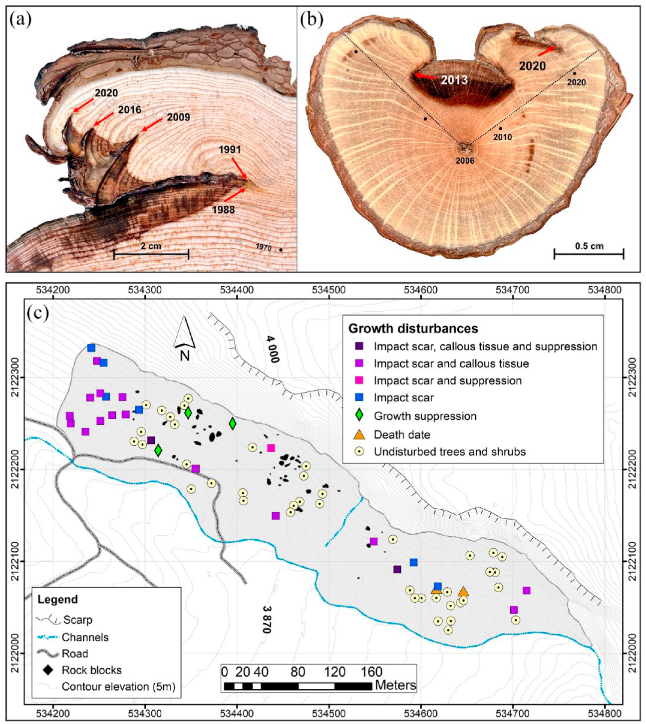
Tree growth disturbances associated with rockfall events. (a) Five scars dated in the tree rings of P. hartwegii (AD 1988, 1991, 2009, 2016 and 2020). (b) Cross section of a 17-year-old Ribes ciliatum (2006 AD) that grew within the rockfall deposit and subsequently recorded two events (2013 and 2020). (c) Spatial distribution of trees with growth disturbances of Pinus hartwegii and Ribes ciliatum along the talus slope.
The last co-dated ring of a dead P. hartwegii trunk was in 1985 (possible year of death). On the other hand, the last co-dated ring of a Juniperus monticola trunk was in 1995 (possible year of death).
Reconstruction of rockfall events and return periods
The rockfall reconstruction period goes from 1900 to 2022. In the second half of the 20th century these events became more recurrent. From 1977 to 1990 there were 23 disturbances associated with rockfall dynamics. From 1991 to 2000, 27 growth disturbances were recorded (mainly in 1991, 1994 and 1998), this being the most active period in the study area. From 2001 to 2010 there were only 9 disturbances in the trees, to increase again in the last decade (2011 to 2020) with 15 growth disturbances in the tree rings. The year 1991 recorded the highest number of impact scars and callus tissues (eight disturbances). Apparently, this event is not related to seismic activity in the region. However, the weather station Tlalmanalco (code 15280) recorded a maximum rainfall of 49 mm within a 24-h period on June 10, which could be related to rockfall at this site.
Another year with important disturbances was 1994, with five anomalies. In that year the months of May, August, and October recorded rainfall above the historical average. However, the maximum rainfall recorded at the weather station San Pedro Nexapa (code 15103) in July did not exceed 31 mm in 24 h, which indicates a low probability of generating instability on the slopes due to extreme rainfall. On the other hand, seismic records show that on 4 July 1994, an earthquake of magnitude 6.1 occurred off the coast of Puerto Escondido, Oaxaca (SSN, 2023), which suggests that rockfall could have been triggered by that seismic event. In 1998, six wood disturbances were recorded, divided into two events, first in the dormancy stage and later in the latewood. The first rockfall event may be related to a February 2 earthquake of magnitude 6.4, near Santa María Huatulco, Oaxaca (SSN, 2023; USGS, 2023). The second event may have a connection with the summer rains recorded at the weather station San Rafael (code 15106) on August 7, with 62 mm in 24 h and a cumulative rainfall of 38 mm in the previous 3 days (100 mm total). Other years that recorded 3 or 4 disturbances were 1982, 1987, 1997, 2000 and 2016 (Figure 5).

Rockfall reconstruction based on growth disturbances of trees in Valle del Silencio. The grey triangles are rockfall events probably related to earthquakes ⩾6 M. Blue triangles are rockfall events probably triggered by maximum rainfall in the previous 24 h and 3 days. Purple diamonds are rockfall events associated with rainfall and/or earthquakes.
The results of the analysis of return periods of rockfall events based on P. hartwegii showed a minimum value of 14 years and a maximum of 172 years, which represents areas of lesser and greater stability, respectively, with a mean of 89 years (±40 years). Thus, two sectors with high frequencies were identified, one in the extreme northwest (14–80 years) and the other one in the central zone of the talus slope (24–80 years), which corresponds to the distribution of young trees with impact scars due to greater instability due to rockfall (Figure 6a).

Interpolation maps on talus slope of Valle del Silencio based on dendrogeomorphological analysis. (a) Return periods of rockfall using Ordinary Kriging method. The areas with the greatest instability are the western end and the central area of the talus slope. (b) Tree age of Pinus hartwegii trees along the talus slope. The green dots show the estimated age. (c) Shrub age of Juniperus monticola and Ribes ciliatum in the most recent rockfall deposit. In the field, a boundary was delineated with GPS between the vegetated area and the area with very little or no vegetation cover. Additionally, rock blocks without lichens were recorded to delimit the most active sector (area with red color).
Age of the forest and minimum ages on the talus slope
The interpolated ages of Pinus hartwegii showed a north-south trend, that is, the youngest trees (<100 years) were located in the sites close to the escarpment wall, while the longest-lived trees >160 years were located in the areas farther away from the escarpment wall. The middle zone of the talus slope presented a sector with the youngest trees (<80 years) around a small channel (Figure 6b). The area above the escarpment of this unstable sector (~70 m high) shows evidence of human activity, forest fires and erosional processes.
In the case of Juniperus monticola, age interpolation revealed that the longest-lived shrubs (>300 years) were concentrated in the center-east (Figure 6c). The age trend of Ribes ciliatum was from south to north, tah is, the longest-lived shrubs (>50 years) were found in the lower part of the deposit, at the boundaries with the valley bottom, while the youngest (<25 years) in the northern sector close to the rock wall (Figure 6c).
Age of lichens and stability of the rockfall deposit
The largest lichens of Rhizocarpon geographicum were measured in the sector of the most recent rockfall deposits, in the eastern part of the talus slope. However, this was not carried out in the remainder of the talus slope as it did not exhibit rock blocks with significant lichen populations. A total of 257 measurements were obtained, however, the largest lichen from each rock block was discarded, as a rule to avoid overestimation of ages, leaving a total of 231 measurements distributed among 26 rock blocks. Then, with the average maximum age of each rock block, an interpolation map of ages was generated. The DEP-RZ08 rock block, located in the southern area of the deposit, revealed a minimum age of 283 years, a maximum age of 391 years, and an average maximum age of 322 years (± 41 year), making it the block with the oldest lichens at the study site. While the DEP-RZ14 rock block, located north of the deposit, exhibited a minimum age of 9 years and a maximum age of 15 years, with an average maximum age of 12 years (±3 year) (see Table in Supplemental Material).
In general, young ages of the species were observed towards the northwest, increasing in age towards the east and south of the talus. In the field, a visually appreciable boundary was delineated with GPS between rock blocks colonized by some type of flora and those devoid of it, as well as the GPS recording of lichen-free blocks with a recent appearance. This enabled the delineation of an active sector located at the top of the deposits, in contact with the escarpment (Figure 7a). This information exhibited certain similarities with the maximum average ages of the lichens, allowing the identification of at least three lobes of rockfall. The age distribution of Rhizocarpon geographicum showed some similarity with the age map of Ribes ciliatum and Juniperus monticola (Figure 6c), in terms of the presence of young individuals or absence of the species in unstable sectors, and vice versa, which reinforces the idea of the existence of at least three rockfall deposits areas at the site.

(a) Lichenometric age with Rhizocarpon geographicum using an interpolation with the Ordinary Kriging method. Values show the average maximum age of the lichens from each sampled rock block (black squares) (Table in supplementary material). Rock blocks without lichens were recorded (white dots). The solid red line represents the GPS-recorded boundaries between the three rockfall lobes. (b) Density histogram of the age of all lichens (n = 231) showing a multimodal distribution.
Discussion
Dendrochronological potential of tree and shrub species
The statistical results of each of the chronologies obtained for the talus slope of Valle del Silencio (P. hartwegii, J. monticola and R. ciliatum) showed correlations between the growth series above the significance parameter established by COFECHA (Holmes, 1983). However, J. monticola presented a low value (r = 0.36, p < 0.01). On the other hand, the three chronologies were compared with each other. The correlation coefficient between the RWI of P. hartwegii and J. monticola from the Silencio valley was 0.15 (p < 0.05), which is low, but significant, compared to the coefficient of 0.26 (p < 0.01) reported between these two species for the Sierra Nevada, suggesting that the low correlations can be attributed to asynchronous periods of cambium activity of the two species (Villanueva-Díaz et al., 2016). The correlation coefficient between P. hartwegii and R. ciliatum was positive, but not significant and the correlation between J. monticola and R. ciliatum was negative and not significant.
Correlations between the RWI of Pinus hartwegii and meteorological records of accumulated monthly precipitation between the years 2013 and 2022 (Altzomoni, RUOA-UNAM) revealed positive trends with the rains of October and November of the previous year, and with the rains from July to October of the current year, as has been shown by another research for this species (Cerano-Paredes et al., 2009; Manzanilla-Quiñones et al., 2020). While the species Juniperus monticola showed a positive correlation with the average monthly temperature, both for the month of November of the previous year, and for the months of February, March, June, and July of the current year, which confirms Huante et al. (1991) when finding high mean temperature values in months prior to the growing season in conifers in Michoacán. For the species Ribes ciliatum, positive correlations were mainly obtained for rainfall in December of the previous year and for the months of February, April, and from June to October of the current year, suggesting that soil water availability (moisture) could have a greater influence on the growth of the species (Jiménez-Noriega et al., 2015).
Tree rings disturbances due to rockfalls
Several studies have confirmed the natural sensitivity of P. hartwegii to climatic changes (Villanueva-Díaz et al., 2015), to volcanic processes (Biondi, 2001) and to fires (Cerano-Paredes et al., 2021). The predominant growth disturbances of P. hartwegii in the talus slope of Valle del Silencio were impact scars, followed by callus tissues and some growth suppressions, as previously reported by Stoffel et al. (2011) and Franco-Ramos et al. (2017a) for rockfall-affected trees in central Mexican environments. In the case of J. monticola, it is a species that has been used for climatic reconstruction in high mountains of Mexico (Villanueva-Díaz et al., 2016) and for the study of minimum ages of volcanic landforms in central Mexico (Alcalá-Reygosa et al., 2018). This research tested the dendrogeomorphological potential of J. monticola, applied to the study of rockfall dynamics in a rockfall talus slope of central Mexico. In addition, the work provides new information regarding the dendrogeomorphic potential of the shrub species Ribes ciliatum in temperate environments of central Mexico.
Rockfall reconstruction and return periods
The results showed an apparent concentration of events on the second half of the 20th century, suggesting that P. hartwegii, like other conifers (i.e. Picea abies (L.) Karst and Larix decidua Mill), shows good ability to compartmentalize and close its wounds, to the extent of weakening or erasing the dendrogeomorphological signal in long-lived trees (Stoffel, 2008; Trappmann et al., 2013). The trees at the study site are relatively young (<172 years), which may be a factor influencing the intensity of the signal recorded in the tree rings.
The analysis of rockfall frequencies revealed that 1991, 1994 and 1998 were the years with the highest rockfall activity on the talus slope of Valle del Silencio. Comparison of these results with other works for the center of the country revealed similarities and contrasts. In particular, in the work of Stoffel et al. (2011) conducted in the same volcanic complex (talus slope of El Rodadero slope, 4.8 km northeast of Valle del Silencio), a temporal window was found between 1992 and 1998, with low to no rockfall activity that contrasts with the talus slope of Valle del Silencio. A general comparison of the two reconstructions revealed that of the 36 events recorded in talus slope of El Rodadero, 15 events (42%) coincide with the rockfalls dated on talus slope of Valle del Silencio, suggesting that these events could have a similar origin (Table 2). On the other hand, at Cofre de Perote volcano, located 160 km ENE of Valle del Silencio, Franco-Ramos et al. (2017a) dated a total of 35 rockfall events, of which 5 (14%) coincided with events recorded in the talus slope of Valle del Silencio, the most important one being 1998 with ⩾6 disturbances at each of the sites (Table 2). These chronological similarities suggest that rockfalls in volcanic environments of central Mexico may be triggered by regional phenomena, such as torrential rains in summer, many of them favored by hurricanes from the Gulf of Mexico and the Pacific Ocean (Franco-Ramos et al., 2017a; Stoffel et al., 2011). Or the dynamics may also be related to the occurrence of moderate to high magnitude earthquakes (M ⩾ 5.5) (Rodriguez et al., 1999) located within an average radius of 300 km from central Mexico to the Pacific coasts, for example, the magnitude 8.1 event of September 1985, or the magnitude 7.1 event of September 2017, which generated slope processes in the south and center of the country (Mayoral et al., 2019).
Relationship between rockfall events in Valle del Silencio and maximum rainfall in the previous 24 h and three previous days, as well as earthquakes with magnitude ⩾ 6.
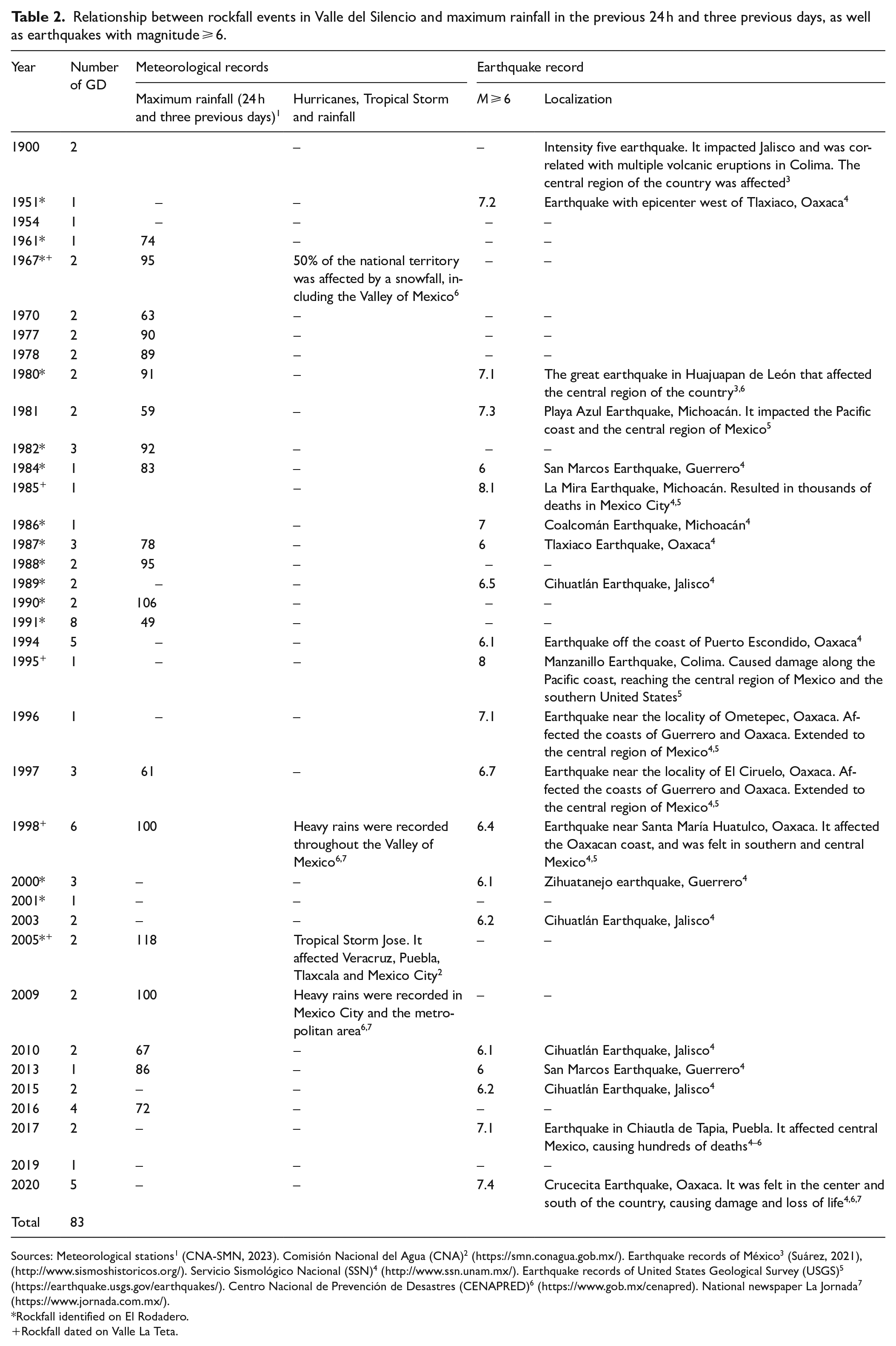
Sources: Meteorological stations1 (CNA-SMN, 2023). Comisión Nacional del Agua (CNA)2 (https://smn.conagua.gob.mx/). Earthquake records of México3 (Suárez, 2021), (http://www.sismoshistoricos.org/). Servicio Sismológico Nacional (SSN)4 (http://www.ssn.unam.mx/). Earthquake records of United States Geological Survey (USGS)5 (https://earthquake.usgs.gov/earthquakes/). Centro Nacional de Prevención de Desastres (CENAPRED)6 (https://www.gob.mx/cenapred). National newspaper La Jornada7 (https://www.jornada.com.mx/).
Rockfall identified on El Rodadero.
Rockfall dated on Valle La Teta.
The mean return period for rockfall based on the study of P. hartwegii in the talus slope of Valle del Silencio was 89 years. In the talus slope of El Rodadero on the northern flank of Iztaccíhuatl volcano the mean return period was 37 years (Stoffel et al., 2011), while in the talus slope of Valle La Teta (Cofre de Perote volcano) the mean was 110 years (Franco-Ramos et al., 2017a). These data suggest that the talus slope of Valle del Silencio presents more stable geomorphic conditions than the one of El Rodadero but is less stable than the one of Valle la Teta on Cofre de Perote. In general, factors associated with greater stability in the Valle del Silencio can be attributed to a lower presence of fractures in the rocks related to both tectonics and glacial erosion (Matasci et al., 2018; McColl and Draebing, 2019; Regmi et al., 2013), as well as the orientation of the slopes to the south, which may favor thermoclasticity but inhibit gelifraction compared to north-facing slopes (Messenzehl et al., 2017).
Regarding the minimum ages and geomorphic stability of slopes based on dendrogeomorphology, the average age of the P. hartwegii forest on the talus slope of Valle del Silencio was 118 years (±31 years), and the oldest stand was 172 years. Our data can be compared with other stands on talus slopes in the center of the country affected by rockfalls, such as the talus slope of El Rodadero where an average age of 86 years (±40 years) and the longest age of 209 years was obtained (Stoffel et al., 2011). Similarly, at Valle La Teta on Cofre de Perote the average age is 155 years (±91 years) and the longest age is 451 years (Franco-Ramos et al., 2017a). The comparison suggests that the Valle del Silencio has a younger stand with greater age homogeneity, the latter possibly attributed to rockfall dynamics that limit tree regrowth in unstable sectors (Schneuwly and Stoffel, 2008; Stoffel et al., 2005) in combination with other phenomena such as forest fires that modify the composition and structure of the stand (Cerano-Paredes et al., 2021), as well as logging. The spatial analysis of tree ages on volcanic slopes provides key information on forest structure and its relationship with rockfall dynamics, as well as establishing minimum ages of geomorphic surfaces. However, it must be considered that tree growth does not occur immediately after the creation of a new surface, since there is a lag time (or ecesis) in which conditions for establishment and prevalence occur (Pierson, 2007).
Lichenometric potential for rockfall analysis
The application of lichenometry for geomorphological studies has generated an important debate in the Earth sciences, specifically on the precision and accuracy of the method for dating events and/or assigning ages to the formation of new landforms. Much of this debate has to do with the wide variety of strategies for sampling and measuring thalli. For example, measuring by axes, by morphologies, or considering only the largest thallus, or the 5 or 10 largest; or using the average of the maxima, among other criteria. Other important aspects to consider are the limiting factors in the growth curve of lichens such as lithology, microclimate, interactions, and population dynamics (competition, mortality, coalescence, fluctuation of growth curves, etc.) (Innes, 1985; Jomeli et al., 2007; Osborn et al., 2015). The measurement method employed in this work was to consider the diameter or major axis of the largest lichens on each rock block. Subsequently, the maximum value on each block was excluded. Finally, we determined the average maximum age of the lichens per block. The calibration of ages was from the growth curve proposed by Palacios et al. (2012), elaborated ~4 km to the southeast in the Ayoloco valley (Iztaccíhuatl) at ~4400 masl (450 m above this study area). Therefore, the error in age estimation should be relatively low.
It should be noted that the lichenometric results should be interpreted as minimum ages, since in many cases the ecesis interval is not known to assign more accurate ages (Graber and Santi, 2022). However, based on lichenometry, more than one rockfall deposit could be identified on the talus slope of Valle del Silencio from the frequency histogram that showed multimodal behavior in lichen diameters (Figure 7b). This can be interpreted as an episodic or recolonization event caused by more than one rockfall event (Lang et al., 1999; Winchester and Harrison, 2000), which is corroborated by the comparison of aerial photographs from 1955 and drone images from 2021 (Figure 8). The reliability of the minimum ages of geomorphic surfaces based on lichenometry will depend on the quality control in the generation of the adjustment curve or growth model, which can be calibrated with other methods such as dendrochronology (Garibotti and Villalba, 2009), as well as on the sampling, since the greater the number of thalli measured, the lower the uncertainty (O’Neal, 2006). Nevertheless, lichenometry can be a viable and low-cost method that allows an approximation of the age of landforms on a time scale of tens, hundreds or even thousands of years, especially in areas above the upper limit of the forest (in the case of central Mexico above 4000 m a.s.l.) where there are no trees or shrubs. Additionally, it can be useful when there are no resources available to use other dating methods such as cosmogenic nuclides and optically stimulated luminescence (OSL).
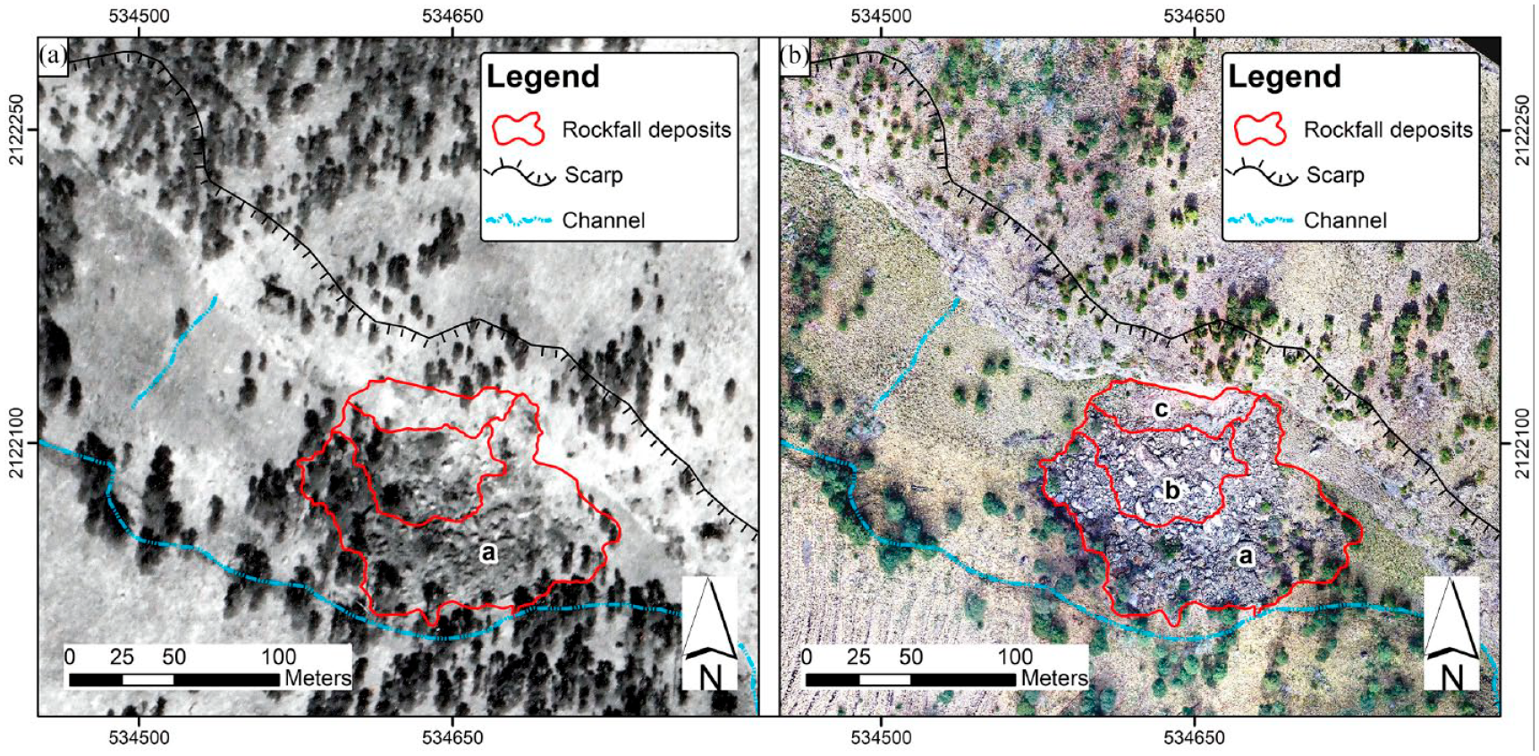
Aerial photographs of the rockfall deposits, distinguishing the older sector near the valley bottom from the younger and more active sector near the escarpment wall. (a) The black and white image was taken in 1955 and shows the older rockfall area (a) [Source: Volcán Iztaccíhuatl, 1955, Fondo Aerofotográfico, FAO (3183). Acervo Histórico Fundación ICA]. (b) The ortho-mosaic was generated by a drone flight in 2021 and shows the old rockfall area (a), the young rockfall area (b), and the most active rockfall area (c).
The analysis in this study revealed that the minimum age of the talus slope based on Pinus hartwegii was 172 years. However, the age provided by the Juniperus monticola shrub growing on the rockfall deposit was 315 years, while one of the oldest lichens of Rhizocarpon geographicum yielded an age of 391 years. Nevertheless, the oldest Ribes ciliatum shrub on the rockfall deposit reached only 59 years. This highlights the importance of treating the data as minimum ages and, where possible, calibrating the results with other methods such as tephrochronology, optically stimulated luminescence (OSL), among others. The ages of the lichens and their distribution in the recent rockfall deposit revealed that there are at least three areas of instability at this site. Furthermore, in terms of the spatial distribution pattern of ages, a certain similarity was observed between the maps of lichens and shrubs over the rockfall deposits, with long-lived ages within the deposit in contact with the valley bottom, as well as young ages within the second deposit at the top and absence of shrubs and lichens in the last sector, near the rockfall escarpment. It is worth mentioning the dendrochronological and dendrogeomorphological analyses applied to the Ribes ciliatum shrub, which has not been reported in other studies, and the use of other resources such as historical aerial photography and drone-captured images to validate these results.
Conclusions
This study provided an annual and sub-annual reconstruction of rockfall events and their spatio-temporal frequencies based on dendrogeomorphology for the last 160 years. In addition, minimum landforms ages based on the age of trees and lichens are viable indicators for assessing the dynamics of rockfall events on high mountain slopes, especially where no historical records exist. Many of the rockfalls follow a regional behavior triggered by torrential rainfalls, sometimes associated with hurricanes, as well as by active regional tectonics.
On the other hand, the work allowed establishing the relationship between the growth of Pinus hartwegii and Juniperus monticola with the high mountain climate of the central region of Mexico, as well as determining the dendrochronological and dendrogeomorphological potential of Ribes ciliatum.
These methods can be used in the evaluation of rockfall hazard at other sites with potential risk to infrastructure and human settlements, as well as serve as a tool for land use planning in Iztaccíhuatl-Popocatépetl National Park.
Supplemental Material
sj-xlsx-1-hol-10.1177_09596836241266433 – Supplemental material for Using dendrogeomorphic and lichenometric approaches for rockfall analysis in the high mountains of Central Mexico
Supplemental material, sj-xlsx-1-hol-10.1177_09596836241266433 for Using dendrogeomorphic and lichenometric approaches for rockfall analysis in the high mountains of Central Mexico by Marco A. Pablo-Pablo, Osvaldo Franco-Ramos, Lorenzo Vázquez-Selem and Julián Cerano-Paredes in The Holocene
Footnotes
Acknowledgements
We kindly thank José Ernesto Figueroa and Mireya Vazquez Rios for their help during fieldwork and in the preparation of samples in the lab.
Funding
The author(s) disclosed receipt of the following financial support for the research, authorship, and/or publication of this article: This research was funded by DGAPA-PAPIIT, UNAM project number IN100522.

Supplemental material
Supplemental material for this article is available online.