
Abstract
This paper investigates the development trajectory and spatial governance practices in the Grand Duchy of Luxembourg, a small but affluent, rapidly developing member state of the European Union. Against the background of globalisation and its urban impact (particularly concerning smaller or emerging metropolitan areas), the paper aims at reconstructing the Luxembourgian urban development trajectory, which is characterised by continuous population growth and successful attraction of global services and financial industries in a rather unique context of the niche sovereignty politics of the small state/small city. The paper also presents a carefully balanced critique of governance practices that seeks to implement integrative strategies in a rather fragmented setting of development, policy and regulation. In so doing, the paper situates this specific case of urbanisation in the context of current paths and narratives of development, particularly with respect to the emergence of global ‘enclave spaces’ and the way these are becoming nested into broader network constellations. The paper also discusses possible consequences for both governance practices and comparative urban studies.
Introduction
The Grand Duchy of Luxembourg and its capital, the City of Luxembourg, have undergone a quite extraordinary economic and demographic development recently. The level of wealth, growth dynamics and international network relations is almost unparalleled, given the size of country (about 530,000 people) or city (about 100,000 people, as of 2013). Luxembourg is a global financial capital and also hosts major European institutions. It is a magnet for a far-reaching international labour market. The daily working population of the capital city is much higher than the number of registered residents. This surplus in terms of importance, evoking William Alonso’s notion of ‘borrowed size’ (Alonso, 1973: 200), is also inscribed in the country’s spatial development. The associated spatial mismatch, however, tends to be more accentuated than in many if not all other cases. It is characterised by a strange relation between jobs and residents in many communities, a significant volume of daily and periodical commutes, and also by dysfunctional real estate markets and, associated with this, extraordinarily high housing prices.
Due to the accelerated economic and urban-regional growth that has been observed recently, urban and regional planning are facing relentless difficulties in keeping development under control. This recalls previous experience gained from rapidly industrialising regions, where planning institutions tried to catch up with the dynamics and consequences of rapid growth. This phenomenon has already been identified by urban historians as a case of ‘flawed urbanisation’ (cf. Reif, 2012), pointing at the gap between infrastructure provision and urban integration on the one hand, and the pressure of development and the increasing demand for land and circulatory capacity on the other hand. The uneven, de-synchronised pace of economic dynamics and building cycles leads to significant disruptions in the built environment, which can be considered unsustainable in both functional and broader societal terms.
In response to such problems, Luxembourgian government and city officials have developed an ambitious planning and building policy, focusing on integrated planning, most notably implemented through large-scale urban projects. These are partly accompanied by spectacular architecture. Its most visible expression is the state-driven urban expansion on the 365-hectare-large Plateau Kirchberg. Although it has gained quite a prominent status in the international planning community, the Kirchberg is by no means the only example countrywide. Rather, it is considered a template for urban policy in Luxembourg in general, triggering a sort of generic planning philosophy based on large-scale projects, and simultaneously aiming at achieving sustainable, integrated spatial development.
Against this background, the aim of the paper is four-fold. Firstly, it discusses globalisation and its urban impact, with particular emphasis being placed on smaller or emerging metropolitan areas that have successfully developed as secondary financial centres, as Luxembourg did recently. Secondly, it aims at reconstructing the Luxembourgian urban development trajectory in this particular context. Thirdly, it puts forward a critical account of related governance discourses and practices. Thus, the paper aims at situating this case in the context of current narratives of growth and development on the one hand, and sustainability on the other. Fourthly and finally, it discusses possible consequences for both governance practices and for comparative urban studies.
The empirical basis of the paper is two-fold: the findings presented here emerged partly from the research project ‘Sustainlux’, which was carried out at the University of Luxembourg (2010–2013), funded by the Fonds National de la Recherche (Carr, 2013a; Carr and Hesse, 2013). The project aimed at deciphering the norms and narratives of sustainability in spatial regards, its programmatic outlines, contradictions and results. The findings of the study were generated in four steps: following a critical reading of the sustainability literature, documents relating to the national trajectory of sustainability policies were the subject of extensive content analysis; afterwards, 33 expert interviews were conducted between 2010 and 2012, in order to establish a major corpus of empirical material that was suitable for discourse analysis. Finally, the researchers’ interpretations of these findings were jointly discussed with a sample group of the interviewees, in order to ensure that fair and appropriate statements could be made against this background. The lines of thought presented by the researchers on this occasion received a high degree of consensus and appreciation among the participants (Carr, 2013b).
Moreover, the assessment of planning processes, successes and failures as presented here resulted from the participatory observation of five major planning processes in Luxembourg over more or less the same period of time. Among these processes were architectural competitions and planning discourses, expert panels of academics and government officials, and also participation in advisory board meetings of a research project. These include the evaluation of the Cité des Sciences in Belval with regard to sustainable development (Le Fonds Belval, 2010–2011), the foundation of the Belval Observatory in 2011, as a platform for the exchange between science and policy on Belval; participation in juries of architecture competitions (housing on Kirchberg; Fonds d’Urbanisation du Kirchberg, during 2011; redevelopment ‘Op de Schmelz’ in Dudelange; Fonds du Logement, in 2009); also the ‘Midfield’ development procedure (Luxembourg, Hesperange, Ministry for Sustainable Development and Infrastructures, in 2010) and the steering committee for introducing an urban development fund (JESSICA) for the Nordstad (European Investment Bank/BEI, 2009–2010).
Globalisation, globalising cities and the emergence of ‘enclave spaces’
Globalisation entails a variety of social, economic, environmental and cultural processes, and it is fundamentally linked to spatial change. There has been much debate in geography and other social sciences in order to situate globalisation in terms of time (history), its impact on different regions of the world, and the degree of integration and interdependence that either binds together or separates different stakeholders and territories from each other (see Dicken, 2011; Held et al., 1999). The significance of globalisation is manifold, and this applies even more to the question of how its outcomes have to be assessed. On the one hand, there seems to be some reason to consider globalisation a ‘buzzword’ (Dicken, 2003: 7) that carries a confusing variety of meanings, being used for different political or ideological purposes. In this respect, hyperglobalist and liberalist assumptions of the world as becoming ‘flat’ (Friedman, 2005) can be distinguished from more cautious views pointing at the increasing ‘spikyness’ of the world as an outcome of global processes, integration and disintegration (World Bank, 2009). On the other hand, there is no doubt that global processes, such as trade and travel, global production networks (GPNs), global service industries or globalising sports and culture, are signifiers of the 20th and 21st centuries. Consequently, globalisation is prominently used as a relevant research paradigm in various disciplines, not least in geography (see e.g. Sparke, 2009).
Certainly most notable in this respect is the significance of globalisation for urban and regional development. Parts of this discussion point towards the emergence of major global centres as control and command units of the world economy:
Since the 1980s, major transformations in the composition of the world economy, including the sharp growth of specialized services for firms and finance, have renewed the importance of major cities as sites for producing strategic global inputs. In the current phase of the world economy, it is precisely the combination of, on the one hand, the global dispersal of factories, offices, and service outlets, and on the other, global information integration – under conditions of continued concentration of economic ownership and control – that has contributed to a strategic role for certain cities. (Sassen, 2012: 7)
Following initial debates on the transformation of places such as London, New York or Tokyo into a product called global cities (Sassen, 2001), the impact of globalisation is also viewed as reaching far beyond this primary level of the urban system. A more process-oriented perspective views globalising cities as a way the global system is shaping cities and regions in more general terms (see e.g. Amin and Thrift, 1994; Marcuse and Van Kempen, 2000; Smith, 2001). In this context, a broader range of locations has specialised in serving distinct and highly competitive functions to meet the needs of global firms and the associated business milieux. This applies particularly to services, which became even more extensively globalised than production systems did, due to the somewhat intangible nature of services. Also, digital technologies have played a particular role in the global distribution of services and the acceleration of exchange and processing.
As a consequence, more recent studies have focused on the global spread of knowledge-intensive business services, such as law, accounting and consultancy (Shearmur and Doloreux, 2009), and even more so on the financial industries (Faulconbridge, 2004; Palan et al., 2010). An emerging geography of money or finance has not only qualified a new understanding of global urbanisation, by placing an emphasis on the role of financial centres such as the three global cities named above (Karreman, 2009). People have also started to quantify the position of certain cities alongside a new global hierarchy, based on indicators such as the number of corporate headquarters of related branches that have been localised there, or transnational network connectivity (see Brown et al., 2010, and other works from the Globalization and World Cities Group/GaWC).
As a result of such re-structuring, however, there are further spatial dimensions that can be detected other than the emergence of global cities. The ‘spatialities of globalization’ (Amin, 2002) are even more complex than to assume a mere re-structuring of scalar order, a re-organisation of the urban system and the emergence of related business spaces. Amin pointed out that the growing routinisation of global network practices ‘signals a perforation of scalar and territorial forms of social organisation’ (Amin, 2002: 395), associated with an intensification of mixture and connectivity, the combination of multiple spatialities, and an erosion of the traditional ontological distinction made between place and space (Amin, 2002; Brenner, 2004).
The most striking issue in this regard is perhaps the emergence of specialised sub-centres of the global financial industries, either located in off-shore tax havens such as the Bahamas, Cayman Islands or Channel Islands, such as Jersey and Guernsey (UK), or in the State of Delaware (US), or in countries such as Austria, Ireland, Switzerland or Luxembourg, which have started to establish more settled financial industries. Usually evolving as an outcome of particular niche strategies in rather specific circumstances of national sovereignty, in some cases it can be argued that new, state-driven business models have been established that way (Grydehoj, 2011). This could also be the case with Luxembourg, where the financial industries were part of a major transition from steel industries to modern services, accompanied by the evolution of its capital city to a European capital, alongside Brussels and Strasbourg (see below).
With respect to the context of development or, better, post-development and drawing upon cases in Asia, Africa and the Gulf region, Sidaway (2007) argued that globalisation has brought about the evolution of ‘enclave spaces’, that is, islands of particular regulatory circumstances – such as export-processing zones, transport hubs, free ports or financial districts – which host specialised economic activities in response to globalisation. These spaces help to orchestrate global flows in a rather fragmented political-economic setting, in concert with a certain unbundling or re-configuring of nationality and sovereignty. This can be observed both within national borders (as ‘graduated sovereignty’), and also as a result of overall state strategy, as exemplified by Sidaway (2007: 335) in the case of enclave globalisation of the Gulf states, most prominently represented by Dubai. According to the author, this pattern of enclaving might even indicate that a ‘new metageography’ of development is emerging. It is no coincidence that Dubai is also among the cases Sigler (2013) explored as representing the archetypes of relational or ‘entrepôt’ cities of the 21st century. Moreover, enclave urbanism appears as a research paradigm that is gaining increasing momentum in the study of globalising cities in developing countries (Wissink, 2011; Wissink et al., 2012).
In the following, this concept is used to situate the rather specific spatiality (or exceptional urbanism) of Luxembourg, whose recent extraordinary growth path is driven by its political economic development model and a small-state version of policy and planning. This model has successfully placed the micro-state of Luxembourg on the map of the global financial industries, yet simultaneously created a rather fragmented, critical urban and spatial setting – characterised by spatial mismatch, an extreme scarcity of housing and an unusually high degree of both international and interregional connectivity and circulation.
New economy, transforming society: borrowed size making an enclave space
The Grand Duchy of Luxembourg and its capital city, Luxembourg City, can be considered exemplary for a hitherto rather successful case of economic transition, based on the sectoral diversification away from iron and steel industries, via the attraction of European institutions, to become a global financial centre. The quite dynamic development trajectory of Luxembourg is characterised by two specificities, compared with urban economic development elsewhere. On the one hand, it took place in a rather short period of time, starting no earlier than from the 1960s onwards. Also, it covers a small territory of about just 2586 square kilometres, today hosting about 530,000 inhabitants and almost 360,000 workplaces (data as of 2013, after STATEC; see also Table 1). On the other hand, this dynamic development is not so much based on a continuous, endogenous development path, but can only be understood in the context of the persistent internationalisation of Luxembourg. Since the 1960s, this trajectory has been fed by strong migration of workers (both construction and services), the establishment of a European capital and later on the creation of a global banking location. As a prospering micro-state, close links between Luxembourg and its neighbour states Belgium, France and Germany have also played a role. Today about 45 per cent of the population is of non-Luxembourgian origin or nationality, in the capital city even about 65 per cent. Among these groups are rather distinct migratory milieux, such as Italian and Portuguese construction workers, bank and investment fund staff, as well as members of the European institutions.
Population and occupation in the Grand Duchy of Luxembourg, 2001–2012.
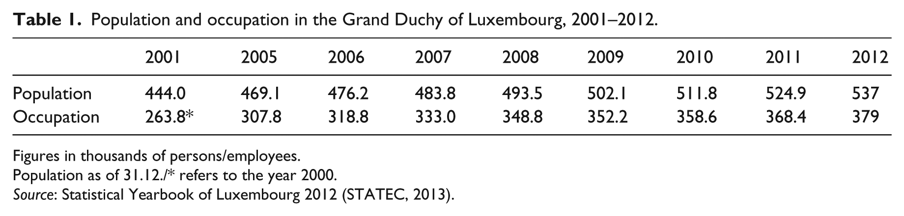
Figures in thousands of persons/employees.
Population as of 31.12./* refers to the year 2000.
Source: Statistical Yearbook of Luxembourg 2012 (STATEC, 2013).
In qualitative terms, this transition of Luxembourg and its capital city is also viewed as being driven by the process of ‘metropolisation’ (Decoville, 2008; Hesse, 2010; Schulz, 2008). It marks the increasing external influence exerted on urban development, particularly in the context of globalisation, and the embeddedness (or not) of a city in large-scale network associations. In the case of Luxembourg, metropolisation means that the rather small place has been able to specialise in a set of functions that are usually confined to major metropolitan areas, particularly gaining a high share of occupation in the financial and corporate services sub-sectors. Luxembourg is not listed among the top 50 cities that are most important in these regards, as for example presented by Sassen (2012). However, judging from its degree of international connectivity, it ranks on the Beta level of the Globalization and World Cities Group/GaWC – alongside capital cities such as Helsinki, Oslo or Budapest, and also much bigger metropolitan centres such as Manchester (UK), Seattle or Minneapolis (USA).
This relatively high significance of the micro-state of Luxembourg is mostly due to the financial industries. According to the study by Walther et al. (2011), Luxembourg represents one of the small or specialised International Financial Centres (sIFCs), ranking on a third level behind world financial centres such as London, New York or Tokyo, and second-tier financial centres such as Paris or Frankfurt. It is ranked here alongside cities such as Geneva or Dublin (Walther et al., 2011: 126). Luxembourg is viewed as a global specialist, since it is one of the leading private banking centres of the Eurozone, the second largest mutual fund centre in the world behind the US, and the leading captive reinsurance market in the European Union (EU) (Walther et al., 2011: 128). The industry evolved from a successive path development based on agglomeration effects, a qualified labour pool (about 55,000 people employed in 2010) and a dense network of social ties, with short distances for interaction and, most notably, a favourable regulatory environment. A large majority of these jobs are localised in Luxembourg City, indicating that metropolitan functions are nowadays not necessarily linked to the territory of a major agglomeration. This does not mean that Luxembourg City conforms to the definition of a metropolis or metropolitan area, but the city is subject to the process of ‘metropolisation’. The logic behind metropolisation is neither the growth of a larger agglomeration into a metropolitan area, nor the upscaling of places in the urban system, but the re-adjustment of urban centrality in the context of globalisation (Sassen, 2012). As a consequence of borrowed size, mobilised by economic specialisation and competitive niche strategies, the close association between the size and the function of a city tends to be dissolved, leading to a new distribution of economic power, away from the old centres and towards newly emerging micro-spaces. Smaller cities and countries, such as Luxembourg, Ireland or Switzerland, but also tax havens and off-shore financing islands, such as Jersey, UK, or the Cayman Islands in the Caribbean, have started to play a significant role in the global economy.
At the regional scale, Luxembourg is also part of a major cross-border labour market, comprising the regions of Lorraine (France), Wallonia (Belgium), Saarland, Rhineland-Palatinate (Germany) and the entire territory of the Grand Duchy. This labour market is estimated to count about 200,000 employees, of which about 50 per cent are based in Lorraine, and three quarters tend to work in Luxembourg. Every workday, about 156,000 employees cross borders and commute into the Grand Duchy, about half of them coming from France, a quarter from Belgium and Germany each (data as of March 2012; source: Interregionale Arbeitsmarktbeobachtungsstelle/Observatoire interrégional du marché de l’emploi/IAB/OIE, 2012). A large majority of these commuters is heading into the capital city.
The surplus in importance of Luxembourg as a small but highly international enclave space evokes William Alonso’s notion of ‘borrowed size’ (Alonso, 1973: 200). According to the author, borrowed size means that ‘a smaller city or metropolitan area exhibits some characteristics of a larger one if it is near other population concentrations’. Alonso associates this property particularly with the population potential of smaller European metropolises, namely in the Low Countries. Such cities are quite small judging by American standards, yet they apparently achieve sufficient scale to function as a modern economy. Borrowed size means a city borrows significance from others with which it normally could not compete. Borrowed size certainly makes a city attractive: it delivers jobs and provides quality of life at short distances, or to use Alonso’s words: ‘It is possible to have one’s cake and to eat it too’ (Alonso, 1973). Although introduced by Alonso some time ago, this term is still frequently used in the context of discussing forms of polycentricity as an organising principle of urban regions. Polycentricity is considered to be the norm rather than exception in contemporary patterns of urbanisation (Parr, 2008). This case study, however, does not focus on analysing the common model of urban extension at the horizontal level, which effectively makes a region become polycentric, but on vertical forms of economic integration, or insertion, of a region in overarching processes, such as globalisation or financialisation.
Under current framework conditions, borrowing size or significance no longer relies on physical proximity between the cities, but on embeddedness in overarching networks between and within polycentric city-regions, via corporate relations, market pervasion and, last but not least, information and communication networks. This seems to be an accepted claim in urban and regional studies (Musterd and Kloosterman, 2001; Priemus et al., 2004). However, the mechanisms that support the emergence of enclave economies based on borrowed size are yet to be understood. There is a wide range of development trajectories possible for secondary places, for example becoming either ‘clones’ or ‘complements’ of larger metropolises, as Meijers (2007) has put it. Besides key factors such as internationality and strong business orientation, regulation certainly plays a key role in this respect: niches of sovereignty are among the most vital explanations for the success of these economic enclave spaces.
Inside the enclave space: from big projects to flawed urbanisation
Borrowed size is inherently inscribed in the country’s spatial development, associated with both particular requirements and impacts. One consequence is circulation, since the rising flows of people, goods, money and services have to be organised, not least in merely material terms. The other impact is spatial mismatch: the fragmentation of urban and regional lifeworlds, spaces and attachments across time and space. This feature has brought about a rather unusual relation between jobs and residents in many communities. In line with a certain ‘politics of property’, that is, the reservation of land that is mostly in the hands of the original population and of developers for speculative purposes, it also triggers extraordinarily high costs of housing. These dysfunctional real estate markets keep many people from affordable homes and property, which has already caused thousands of Luxembourgers to seek property abroad. Thus the shadow side of the Luxembourgian growth model is relatively obvious: real estate markets have largely prioritised office space over housing, and so did land use planning at various levels.
Key characteristics of the housing sector are extreme scarcities both in the property and rental sectors (Becker and Hesse, 2010). Even taking the high salaries and incomes of Luxembourgers into account, it remains crucial that rents and house prices are on average twice as high as they are in the neighbouring countries. Additions to the housing stock remain fairly limited, which has to do both with the scarcity of developable land on the real estate market (caused by supply-side ‘inertia’) and a reluctance of the local authorities to expand their building perimeters. Due to the rise in office space that has been developed, particularly smaller local authorities in the vicinity of the capital city are suffering from imbalances between office and housing floor space, as data for the south-west suburbs of Luxembourg City reveal (Table 2). It is likely that these imbalances will remain prevalent in the foreseeable future.
Population and occupation in suburban communities of Luxembourg City.
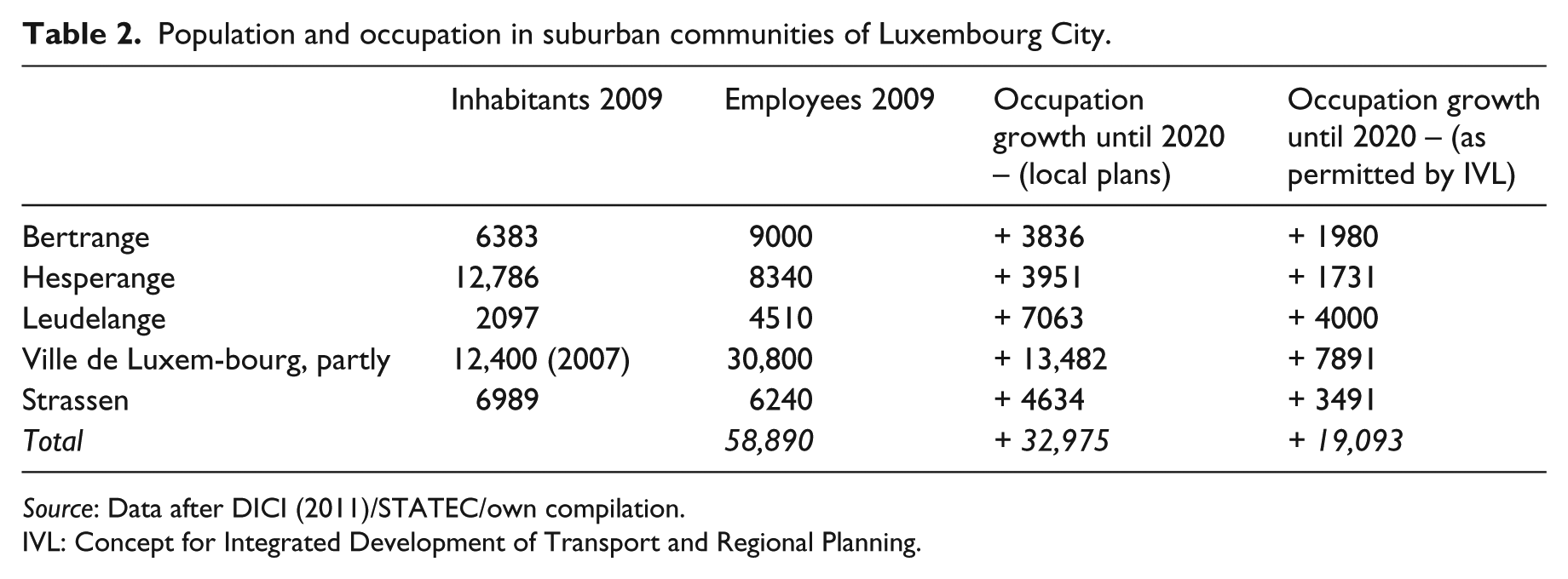
Source: Data after DICI (2011)/STATEC/own compilation.
IVL: Concept for Integrated Development of Transport and Regional Planning.
Due to the accelerated pressure of economic and urban-regional growth, policy and planning are facing relentless difficulties in keeping development under control. This recalls former experience of industrialising regions, where planning institutions tried to catch up with the dynamics and consequences of rapid growth. Urban historians have termed this ‘flawed urbanization’ (Reif, 2012). Extraordinarily rapid development, as was the case with industrialisation in the late 19th/early 20th centuries, brought about a significant gap between infrastructure provision and urban integration on the one hand, and the pressure of development and increasing demand for land and circulatory capacity on the other hand. This phenomenon very much resonates with the spatial setting of the service industry areas in Luxembourg. What was once a growing demand for land, resources, labour and money from industrialists, is now the case with the international services industries, due to the profit generated from international office real estate markets. The more one zooms in on the country, the more islands such as Kirchberg, Clôche d’Or, Munsbach, Belval and others appear (see Figure 1). They tend to be well linked to their business partners world-wide, yet their situation is rather disconnected from their local environment. Most paradigmatic in this respect is the Kirchberg office town, where many European institutions and also a certain range of banks and investments funds have been located (Hesse, 2013).
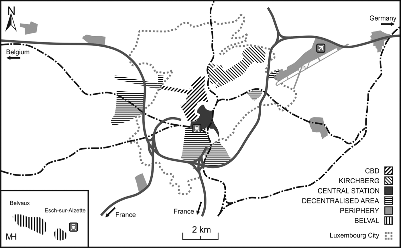
Office locations in Luxembourg.
The Kirchberg started to develop in the early 1960s, managed by the state-owned Fonds Kirchberg. The goal was to localise European institutions, banks and investment funds in Luxembourg. Through this, the area got its rather specific urban design as an office town, highly accessible for commuters by car. Major urban components of the Kirchberg were based on a plan by the French urbanist Pierre Vago, comprising the sub-division of the area into different quarters, two major road corridors (with the 3.5-kilometre-long John F. Kennedy Boulevard as the central axis), and also ambitious architecture with scattered high-rises. Today the Kirchberg offers 920,000 square metres of office space, with an additional 240,000 square metres under construction, and another 220,000 square metres to be added in the medium term. According to the Fonds Kirchberg, about 31,000 jobs are hosted in Kirchberg today, and about 2400 people are currently living there; in the medium term, it is expected that jobs will rise to about 50,000, and the residential population to 7000.
The paradigmatic function of the Kirchberg has unfolded in two different ways. Firstly, urban development in Luxembourg (the capital city and the country) often represents a melange of many isolated buildings, rather than being grounded in a coherent idea for the whole setting – and in this respect it resembles the Plateau Kirchberg. Secondly, the specific framework conditions of the case of Luxembourg – rapid growth, high degree of internationalisation, embedded in global networks and flows – are taken by governing institutions as a rationale for realising a whole range of large-scale projects in urban planning and design. Given the specificities of the political economy, it is not the post-1960s urban design imperatives of the Kirchberg that justify critically re-thinking building and planning policies in Luxembourg. Rather, the problem at stake here is the iconic role that the Kirchberg plays for a predominant, if not hegemonic approach to planning and building in general. Effectively, the Kirchberg marked the starting point of a certain trajectory of urban development and planning in Luxembourg, where a whole range of similar practices was unfolding. These projects include the ongoing construction of the new Cité des Sciences in Esch-Belval, the master plan for the fairly rural Nordstad, and also a couple of projects in the capital city.
These projects are bringing about prototypical enclave spaces that, in their very functional specialisation, are built upon borrowed size. As they are most specifically designed for providing office space for international service industries, they lead to rather flawed patterns of urbanisation and urbanism. Consequently, as these projects are an integral part of the Luxembourgian planning trajectory, they contribute to problems, not to solutions. They are obviously far too big to be easily integrated into the urban fabric, and they face risks well known from other large-scale urban projects, such as rising costs, delays in realisation, planning and governance problems (Swyngedouw et al., 2002). Also, many of the small municipal administrations normally lack the planning capacities required to successfully steer such projects; as a consequence, the power of private agents becomes unusually high, lacking effective public control. The contemporary attitude of planning and building policies is materialised in the provision of office space for international organisations and the financial industries. It is predominantly economic. Thus, large-scale urban projects even reinforce the tendency towards a spatial mismatch, which is inherent in the country’s development path, rather than create more adaptable, resilient urban patterns. This contradiction fits oddly with the official beliefs of the political and administrative elites who bemoan the disintegrated spatial development in a rather routinised way, whilst at the same time they seek to allow even more office towns, shopping malls and private condominiums to emerge.
Practices and problems of spatial governance
This section discusses the normative frames that form the overarching policy and planning in Luxembourg, and the associated beliefs of political and administrative elites on how the world is organised and how it should look. The standard policy rhetoric in official Luxembourg points at ‘integrated development’. Spatial planning as a legal framework is institutionally based on a law of 1999. 1 Hence related framework plans are rather recent, such as the Programme Directeur d’Aménagement du Territoire of 2003 (Ministère de l’Intérieur, 2003), the Concept for Integrated Development of Transport and Regional Planning (IVL) of 2004 (Ministère de l’Intérieur, Ministère des Transports, Ministère des Bâtiments publics, Ministère de l’Environnement, 2004) 2 or the National Plan for Sustainable Development (PNDD) of 2001, updated in 2011 (Ministerium für Nachhaltige Entwicklung und Infrastrukturen and Joachim H. Spangenberg, 2011). The IVL is broadly inspired by the German concept of decentralised concentration. All plans promote – expressis verbis – integrative approaches as their programmatic credo, particularly a balanced spatial pattern at the national level and a clear tendency towards densification locally. Sectoral plans for housing, mobility, landscape and industrial zones are supposed to provide concrete implementation (see the overviews by Chilla and Schulz, 2011; Carr, 2011). Three major growth poles have been determined in order to bundle economic development and building activities: in the rural north (creating the Nordstad agglomeration), the southern Minette, and in the capital city. At the local level, a sort of ‘sustainable urbanism’ is asserted, predominantly by concentrating development and increasing building densities.
The starting point of IVL-based planning strategies is the mismatch between labour (or office space, respectively) and housing. Two scenarios were developed in order to look into the Grand Duchy’s future. According to the so-called commuter scenario, 75 per cent of the workplaces envisaged to be provided by 2021 would be occupied by commuters. The related number would thus increase significantly; also, the number of inhabitants would increase only slightly (up to 511,000). Cross-border commuting would rise, but the pressure on land development might not rise accordingly. In contrast, the so-called inhabitant scenario foresees that the majority of new job-holders would reside in Luxembourg. This would allow the population to grow to 561,000; commuters would represent 40 per cent of employees. Judging from early 2013 figures, it can be argued that the development dynamics do not favour either one of the two scenarios, but both: population has already been growing towards 530,000, and the number of commuters is only 10,000 below the quantity that was predicted for 2020; jobs have grown by almost 10,000 a year (see Table 3).
Concept for Integrated Development of Transport and Regional Planning (IVL) 2004 and current update.

The table indicates the pressure of growth and development in Luxembourg. What was predicted as alternative scenarios to materialise by 2020 in the IVL (published in 2004) is now almost achieved as of 2013 – in both categories.
Source: compiled by Constance Carr, UL (based on IVL, 2004; Statec, 2013).
The burden placed by economic success (growth) on the spatial environment is obvious, and the political economy is feeding this dynamic further, instead of moderating it. Hence it can be questioned whether the Luxembourgian reading of ‘integration’ provides appropriate responses to these problems: the logics that are at work here on the two different levels – national and local – are seriously in conflict with one another. What seems to be reasonable at the regional scale (decentralised concentration) leads to massive problems locally, due to the exaggerated building densities of large-scale urban projects, which are hard to integrate. Also, integration by sheer density is an essentialist idea based on the formula of the old city, with typical pros, cons and pitfalls. This seems to be even more the case in the fluid, flexible and perforated space of enclave economies. The fragmented urban-regional landscapes of Luxembourg are more difficult to manage than ordinary city-regions. Hence, simply calling for integration is at best unrealistic, if not fundamentally contradictory.
Finally, the way such policies are implemented tends to follow a rather rigid, technocratic way of decision-making. This applies particularly to the strong role of the nation state and the lack of citizens’ participation. Decision-making in the enclave space is still very much state-centred (see Jones and Jones, 2004). It leaves any inclusive, participative governance out of consideration. The state sees its primary task in co-ordinating sectoral and local policies through the means and strategies of regional planning. In contrast, the mostly small municipalities are primarily seeking growth and development. Despite the guidelines of decentralised concentration focusing on growth poles, those areas were disproportionately expanding that were not favoured by state planning: smaller communities located off the dedicated focus areas (CEPS, 2010). In the case of major planning projects, local pressure for granting planning permits is usually high and often renders spatial guidelines obsolete. Moreover, the Luxembourgian steering constellation is particularly complex if not delicate, as more than half of the members of the National Chamber (parliament) simultaneously have local municipal mandates; hence, they are committed to pursuing both state and local interests.
As a consequence, the power relation between the state and local authorities seems to be rather peculiar, and the scope of implementation of state planning ideals remains effectively low. Implementing projects is often the domain of private agents, not least due to scarce resources of the mostly small towns and municipalities. Hence, it is the usual practice that private planning offices are in charge of developing land use plans, not the municipalities themselves. Developers, the so-called promoters, are essential for allocating property and realising building projects. They also tend to co-operate with private planning offices, in order to screen the local markets as soon and as comprehensively as possible.
At this stage, two major problems can be identified. Firstly, there is a lack of strategy building particularly among the smaller local authority districts. There is no conceptual guideline for urban development in existence that could come close to what is being formulated for state planning of the country as a whole (even if these strategies appear more abstract, not appropriate). Secondly, the ideas and ideals developed at the local (=> growth) and national (=> order) levels do not have a common ground, and do not follow a common rationale. The conflict between state planning from above and regional-local, self-organisation from bottom-up is key to understanding Luxembourgian governance in institutional terms. This seems even more obvious when assessing large-scale urban projects: in the case of private developments, any political or planning influence seems to be hard to exert; in the case of public development enforced by state-owned agencies (such as in Kirchberg, Belval), these projects tend to be so big that they accumulate enormous operational and financial risks and are rarely open to modification and local adjustments.
As a result of this power mismatch, spatial governance is confronted with the variegated and thus competing functional logics of each scale: what might be reasonable when viewed from the state perspective could turn out to be rather critical locally. This constellation, not extraordinary as such, becomes critical given the political economy, local growth discourses and the inclination to realise large-scale urban projects. Thus, both state ideals and local plans tend to create flawed urbanisation rather than adaptive patterns. The planning systems in Luxembourg’s neighbouring countries attempted to mediate between the conflicting interests of the state and local interests by implementing regional planning. The Grand Duchy is obviously too small to follow this path. In response to this problem, state planning is going to promote regional co-operation where possible. Four so-called ‘convention areas’ have been created in the rural Nordstad, in the Alzette valley north of the capital city, in the DICI area south-west of Luxembourg city, and among five municipalities close to Luxembourg-Findel airport. The local authorities receive financial support from the state and develop de facto informal, yet contract-based joint projects in land use, mobility issues or in sustainability. Such co-operation may help to fill the vacuum between state and municipalities. It remains open, though, how to overcome the contradictions between state authority and large-scale projects on the one hand and local improvisation, the business-as-usual in building and planning on the other.
Pathways and contexts for steering the exceptional urbanism
Where should urban and regional development go in Luxembourg in the near future? How can both borrowed size and flawed urbanisation be properly addressed? First and foremost, these specificities and particularly the growth pressure exerted by the political economy/business model should be reflected as the major framework condition that determines any policy practice. This means that land use, circulation and property issues can no longer be handled as distinct and separate from the template and imperatives of the enclave economy. The fundamental challenge for the government is to recognise the very specificity of this setting and to develop related strategies of adaptation and compensation, rather than to deploy ‘integrated’ visions in an immanently disintegrated environment. Conventional discourses on spatial development and urbanism, however, do lack a proper recognition of the specificities of the case of Luxembourg as an enclave economy. As long as the provision of office space drives the spatial economy, most conflicts will remain on the agenda. Medium-term framework conditions must be taken into account here, such as the future of the financial district, which seems to be resilient in the face of the current crisis, yet also reveals certain vulnerabilities in the longer term, given the changing regulatory framework conditions, for example tax regimes, in Europe (Derudder et al., 2011; Walther et al., 2011). The same applies to the assumption of an annual gross domestic product (GDP) growth of about 4 per cent that is required for keeping the welfare state at its current level of provision (Schroeder, 2007); however, annual growth rates have been significantly lower recently. The hope of maintaining the high standard of wealth at current levels represents an important signifier of the Luxembourgian society model: it is an accepted consensus of government and civil society (including corporations and unions) that this growth model is supposed to be maintained. As a consequence, the enormous pressure exerted hitherto on the built environment, infrastructure and natural resources will continue to be exerted in the near future.
Secondly, it seems appropriate to re-think and re-adjust power relations, not only for dealing with the contradictions and conflicts between the state and the local authorities, but also to re-assess the ideological power of the state. Ideology is an important means for the state to frame problems and to discuss possible solutions (Gualini, 2010; Steger and McNevin, 2010). It is based on particular traditions, norms and beliefs among the professional experts and institutions that underlie the hegemonic discourses on what a problem, or ‘the’ problem, might be and what a solution could look like (Gibbs and Krueger, 2012; Bevir and Rhodes, 2001). This set of beliefs is also instrumental for thinking about what kind of strategic governance model would fit in the future and how it could be implemented.
Against this background, thirdly, there are certain practical steps that need to be developed for solving those issues that are considered to be most important and most urgent. Based on the above analysis, this could include various elements. On the one hand, developing a sense of strategy would be required, by thinking beyond today’s problems and next year’s challenges, particularly in urban and municipal regards. Again, developing strategic capacity must be linked to the political economy, otherwise it will have no real impact. On the other hand, developing a culture of public participation seems to be essential – particularly since the Luxembourgian policy practices bear some of the well-known ‘weaknesses of strong ties’ (cf. Granovetter, 1973): the small, intimate milieu of political decision-making tends to be selective, impedes innovation and harmonises issues, where a more open, transparent culture of conflict would indeed be appropriate. Against this background, a more balanced spatial development should be pursued, not necessarily according to the classic guideline of ‘integrated’ development in the traditional sense, which would not fit with the specificities of the locale. Balanced development in the first instance would particularly mean targeting two pressing issues: (i) improving circulation, by approaching the perforated landscape of enclave mobilities from outside the country, and (ii) providing more, more affordable and high-quality housing in the country. This could particularly include new institutional approaches, such as co-operative housing, in order to break the monopolies of commercial developers and real estate agents, thus overcoming the prohibitive price system of Luxembourg’s real estate. New housing approaches would have to serve the different needs of various target groups: both those who are driving the system of borrowed size and live in Luxembourg only temporarily, and also families and students, to name but a few.
A ‘smart urbanism’ (Campbell, 2010) could be the formula for re-designing and re-packaging such a set of more adaptive spatial policies in Luxembourg for future development, rather than just going for growth and the global. This is not because small is always beautiful, but because it allows more flexibility in the face of different needs in a more complex environment. Such smart urbanism does not mean simply implementing recipes of ‘green cities’ or sustainable quarters. It is much more sophisticated, due to the specificities of the place mentioned earlier. How realistic would it be to implement this, in the context of the rare case of an enclave space and a set of smaller local authority districts in general? There is a chance that future potentials can be mobilised just by smaller metropolises such as Luxembourg rather than the big ones: their advantage lies of course in their international nature and multi-lingual competence, their openness for innovation, their flexibility and agility in operational terms. The Luxembourg trajectory is characterised by the ability of state and society, local authorities and corporations to continuously re-invent themselves. This potential could be brought to fruition for future governance of cities, smart urbanism and spatial development.
Challenges for the comparative study of enclave-space governance
Luxembourg appears as a small but globalised micro-metropolis, an enclave space within a scattered system of service archipelagos, globally integrated and locally disintegrated, steered by a strong sense of political autonomy at both state and local levels, managed in an overall setting of ‘graduated’ niche sovereignty and overall state power. It rests on the successful overall strategy particularly of state agents to create an enclave economic space, based on borrowing size and significance from sectors that are typically prevalent at larger metropolises, which have become instrumental for globalising the economy at this distant micro-space. Enclave economic transformation has thus contributed to the emergence of a new type of relational city (Sigler, 2013) or region (Paasi, 2013; Varró and Lagendijk, 2013). These specific framework conditions, not least the recent development path and its ideological framing, have brought about a sort of ‘exceptional urbanism’ – locally fragmented, yet globally connected. The ultimate question here is: how can this enclave space constellation fit into comparative analysis, and what could be an appropriate methodology to make sense of it? It seems that this case of small-state/city-state has indeed more in common with examples such as Dubai or Singapore, rather than with London, UK, or Paris, France – metropolises whose agglomeration economies are not only much bigger, but that are self-reliant in terms of economic specialisation, market potential and externalities.
These properties make it also quite difficult to discuss enclave spaces in the context of general concepts offered by planning or governance theory. Given the contradictory meta-narratives of both welfare-oriented and growth-oriented development (cf. Law-Yone, 2007; Slemp et al., 2012), this case remains difficult to relate to common schemes and overarching theories. Although the role of the state seems to be powerful, policy and planning are more complex than to allow one to assume a sort of ‘top-down’ regime, not least because of the strong sense of the municipalities’ autonomy. Spatial governance obviously follows more the logic of negotiations – even where normative outlines such as the IVL in Luxembourg tend to be rather abstract, technocratic. This regime of negotiations has been established rather directly; it does not seem to be a product of strong formalisation of planning, which is then followed by a more informal, communicative turn, as could be observed in many other international cases. Seeking consent is traditionally the usual practice in the Grand Duchy, often bringing about ‘post-political’ processes and results (cf. Allmendinger and Haughton, 2012). This means that the national ‘model’ aims to become commonly accepted in a way that leaves almost no space for conflict and counteraction. As a more suitable possible reference point, Pierre’s Models of Governance (1999) offer a framework within which the particular mix of corporatist and welfare politics of Luxembourg could be situated. As a foreign colleague observed on his first visit to the country, he perceived the policy framework as a somehow bizarre mix of ‘socialist’ (welfare) state and entrepreneurial, new economy strategy. It is essentially a hybrid of ‘negotiative’ and ‘techno-corporatist state’ (Healey, 1996) that is at stake here, with certain ingredients of neoliberal urbanism (Peck et al., 2009), and a strong emphasis placed on competitive city-regionalism (Ward and Jonas, 2004).
The case of Luxembourg also brings a substantial challenge to the wider realm of policy studies. It is notable that the idea of integrated planning was actually imported from neighbouring countries such as France or Germany, as the country’s policy trajectory has long been open-minded, international and actively European (EU-oriented). Yet it still needs to be proven whether such policy mobility can be effective at all. The particular shortcoming of the current leitmotif of integrated planning (IVL) demonstrates that the importing of ideas and ideals from other countries (whether these are neighbours or not) always brings rather distinct planning systems, cultures and traditions together. However, the imported frame most often does not reveal appropriate answers to the specific problems of a given area. These problems tend to be actually distinct and require appropriate strategies in each case. The high degree of international correspondence, if not determination of the Luxembourgian development path provides an argument for discussing relational rather than primarily spatial models, theories and ‘recipes’ (McCann and Ward, 2010). However, current discourses on the various corners of the political system (such as state, local authorities, non-governmental organisations (NGOs)) are almost entirely silent on this point. Given the historical fact that the Luxembourgian development path was created on the basis of internationality and network embeddedness, it also makes sense to devote a more careful analysis to related policy mobilities (McCann, 2011), and to confront this particular field of research with the rather specific, if not exceptional urbanism of Luxembourg.
Footnotes
Acknowledgements
I am grateful to Robert Krueger, Worcester Polytechnic Institute, Massachusetts, USA, for a careful reading of an earlier version of the paper. My thanks also go to the Editor and a referee of European Urban and Regional Studies for critical comments, and also to Margret Vince, Nottingham, UK, for proofreading of the manuscript.