
Abstract
Ensuring agricultural sustainability with escalating population is a real challenge before humanity. At present, heightened demand of state’s rich farmland for non-agricultural activities is posing a pressing need for assessing the prospects of agricultural sustainability. Being a part of central Brahmaputra floodplain in Assam, Sipajhar revenue circle of Darrang district has experienced extraordinary population pressure on land resources over time, which leads to vulnerability of agro-ecological conditions. As per census report, the circle has witnessed 108% increase of population over 40 years. The circle with diverse agriculture and its allied activities has borne the brunt of population pressure in some caste-community concentration areas. The present study assesses the prospects of agricultural sustainability across the gram panchayats of the circle on the basis of six sustainability indicators, namely castes and communities; agriculture and allied practices; spatial pattern of crop productivity; agricultural input–output relation; agro-ecological conditions; and sustainable methods of agriculture selected from social, economic and ecological dimensions of sustainable development. After synthesising these indicators, prospects of agricultural sustainability have been assigned to three groupings of gram panchayats in the circle. This investigation is also intended to provide a rationale for future orientation of agricultural planning in laggard districts like Darrang of Assam.
Keywords
Introduction
Sustainability of agriculture is ensured if it conserves natural resources while meeting the farmer’s needs (Gomez et al. 1996). However, exponential growth of population and consequent irrational geo-ecological change have posed a serious risk for ensuring sustainable agriculture. It is estimated that ever increasing population will lead to 70% increase in demand for food crop production by the mid-21st century and 60% of the natural ecosystem supporting production system will be utilised in a non-sustainable manner (Abhilash et al. 2016; Montanarella and Vargas 2012). Population growth and dietary changes are driving sizable demand for agricultural products, while constructional activities are squeezing pressure on the nation’s rich farmland. It is more so in the state of Assam, as it is estimated that over 6,133 hectares of agricultural land have been already transferred into non-agricultural category across the floodplains of Assam (Press Trust India 2014). The population of Sipajhar revenue circle, Darrang district, Assam has increased from 59,130 in 1971 to 122,937 in 2011 witnessing 108% increase over the last 40 years (Directorate of Census Operations, Assam 2011). This enormous growth of population ultimately has put pressure on the arable land of the circle. The revenue circle is a part of central Brahmaputra floodplain of Assam, which is popularly known as the ‘rice bowl’ of Darrang district. The other concern is that when there is pressing need for food production, there is declining trend of youth participation in agriculture. It is observed that India accounts for 7% decline in number of cultivators from 2001 to 2011 (Gupta 2016).
At this juncture, ensuring sustainable agriculture becomes all the more important and challenging (Abhilash et al. 2016). Even India’s vision for a self-reliant nation lies in promoting rural agricultural economy, which is the only resort to recover the economy from any crippling crisis. To that end, we need to assess the prospects of sustainability in the concerned area before implementing it. An overview of literature reveals that so far, there are no widely accepted standardised methodologies of sustainability assessment. Currently, many indicator-based methods are prevalent to gauge the sustainability of agriculture, which vary with purpose of study and conceptualisation of the term ‘sustainability’ (Binder et al. 2010). In this backdrop, this article attempts to elicit the prospects of sustainable agriculture across the Sipajhar revenue circle by using six coexisting indicators from three dimensions as follows:
Castes and communities; agriculture and allied practices from social dimension. Crop productivity pattern and economic input as determinants of agri-output from economic dimension. Agro-ecological components and sustainable methods of agriculture from ecological dimension.
Objectives
The main objective of the study is to assess the prospects of agricultural sustainability based on six indicators selected in the area. The specific objectives are
To examine social and agro-ecological dimensions of the area in a spatiotemporal context. To analyse the pattern of crop productivity and agricultural input–output relation of economic dimension in the study area.
Database and Methodology
The present study is based on both primary and secondary databases. The 14 gram panchayats (GPs) of the revenue circle are considered as the spatial units for this investigation, and 23 sample villages (26% of total villages) have been selected for primary survey in 2015–2016. Relevant secondary data on population and cropping pattern have been collected from Revenue Circle, Irrigation and Agriculture Office, Darrang; Revenue Circle, Sipajhar; and Census Handbook of Assam and Darrang. Information concerning agro-ecological conditions is acquired from processed data of Landsat TM/LISS satellite image. The data obtained for agro-ecological, social and economic dimensions are processed by employing traditional and sophisticated statistical measures.
The Study Area
Sipajhar revenue circle is situated in the south-western part of Darrang district in Assam, India (Figure 1). Its north-south and east-west extensions range from 26°09′N to 26°22′N latitude and 91°45′E to 91°52′E longitude, respectively. It covers an area of 299.87 km2 (29,987 hectares) comprising 89 villages and 14 GPs wherein 70% of the total working population is engaged in farming practices. The net sown area is 21,217 hectares accounting for 71% of its total geographical area. The arithmetic and physiological density of the circle are 410 and 6 persons per hectare, respectively.
The Central Brahmaputra valley consists of Darrang, Sonitpur, Marigaon and Nagaon districts (Taher 1975, 1986). The mighty Brahmaputra River and its three north bank tributaries, namely Nanoi, Barnodi, Saktula originating from Himalayas create an extensive floodplain throughout the revenue circle.
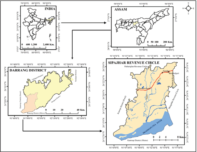
The circle consists of three micro-physiographical units—the active floodplain or charland (areas of new alluvium) (40–45 m), marshy low-lying area with low hills (<40 to >100 M) and the middle plain of the built-up region (45–60 m). The charland in this region is the deposition of new alluvium soil by the Brahmaputra River and its tributaries. The marshy and low-lying areas are to the south-west of Sipajhar revenue circle formed by the Nanoi and the Barnadi rivers. Pukhuria, Boro and Maliata, Diplinga are major beels (wetlands) and Kurua, Baman and Ganesh are the hills and hillocks in this physiographical unit.
Result and Discussion
Peasants’ Castes and Communities with Spatial Concentration (Indicator One)
The present social scene of the Sipajhar revenue circle is a mosaic of few sociocultural groups coming from different ethno-linguistic, sociocultural backgrounds. These sociocultural groups are settled in three micro-physiographical units of the circle. The fact remains that forward or backward looking of varied castes and communities of farmer in central Brahmaputra plain gets reflected in their level of inclination towards performing agricultural and allied practices and thereby brings about some spatial variations in the agricultural pattern of the area. Singh and Dhillion (1995) also argue that in India, the degree of progressivism, conservatism and sluggishness among farming communities can be determined by caste–community factors. Thus, indicator one attempts to investigate the spatial concentration of farming castes and communities along with their social backgrounds.
There are five socially identifiable communities and three castes in Sipajhar revenue circle, namely Indigenous Non-Tribal Hindu, Indigenous Muslim (IM), Nepali, Scheduled Tribe (ST) and Non-Indigenous Muslim (NIM) community. The three castes of Indigenous Non-Tribal Hindu community form a hierarchical order in social system. These are Other Backward Class (OBC) comprising mainly of Yogis (clan of god Siva) and Koches (descendants of royal Koch dynasty); high caste (HC) consisting of Ganak (astrologer), Brahmin (priestly clan), Kalita and Keot (descendants of Kshatriya); and Scheduled Caste (SC) comprising Hira (potter), Jaloa (fisherman), Sonari (goldsmith) and Bania (traders) (Das 2012).
Caste–Community Concentration in Gram Panchayats of Sipajhar Revenue Circle, 2011.
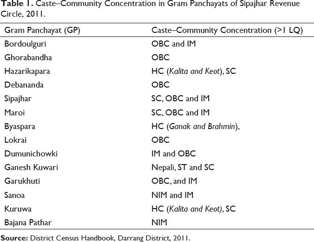
GPs having more than one LQ value of caste–community population are designated as HC-community concentration area; the relative concentration is observed from Table 1. Out of 14 GPs, Ghorabandha, Lokrai and Debananda register the highest concentration of OBC, while there is a high concentration of HC in Byaspara, Kuruwa and Hazarikapara GPs and of SC in Maroi, Ganesh Kuwari and Kuruwa GPs. The IM communities have relatively high concentration in Dumunichowki and Bordoulguri GPs. These communities are largely settled in built-up physiographical unit. On the other hand, NIM communities are exclusively concentrated in Sanoa and Bajana Pathar GPs of charland areas. The Nepali community is mostly concentrated in Ganesh Kuwari and Bajana Pathar GPs, while the ST (Bodo) community has a high degree of concentration in low hills areas of Ganesh Kuwari GP.
Participation of Castes and Communities in Agriculture
Farming communities of society are the backbone of agriculture system connecting with soil. Agricultural sustainability can only be ensured by the active and ceaseless participation of farmers. It is worthwhile to note that the inclination of peasant communities towards farming is not uniform across the circle. The District Census Handbook of Darrang reveals that the proportion of main cultivators to total workers has declined from 45% in 2001 to 43% in 2011 in the circle. Similarly, the marginal cultivators of the circle constituted 11% of total workers in 2001, which has fallen to 10% in 2011. However, it is worthwhile to mention that there is spatiotemporal variation of community participation in farming practices across GPs of the circle. Such variation can be attributed not only to physical but also to sociocultural factors, that is, caste system, farm force, land tenure, family structure, customs and traditions.
It is observed that out of 14 GPs, Bajana Pathar, Sanoa, Garukhuti, Bordoulguri, Hazarikapara and Debananda have registered the highest increase in main and marginal cultivators in 2001. These are the areas where there is high concentration of NIM, IM, OBC and some HC communities. They are the leading farming castes and communities taking responsibility of feeding the masses of the society. Kalita and Keot (HC) of Hazarikapara and Kuruwa GPs are actively adapted to agriculture. Unlike them, HCs belonging to Ganak and Brahmin of Byaspara, are not directly engaged in the field, though these groups possess plenty of farmland, and all activities from tilling to harvesting are performed by their land tenants. They often face shortage of land tenants for farming. Hence, Byaspara GP with majority of HC group has experienced a decline in cultivators over the years.
On the other hand, the SC group (Hira, Jaloa, Sonari and Bania) are not traditionally agriculturist; rather, they used to be engaged in various tertiary and secondary activities, that is, pottery making—Hira; fishing—Jaloa; trading—Bania; and goldsmithy—Sunari. Some of them have got into agriculture in the recent past due to the declining scope for their traditional activities.
The Nepali community were traditionally dairy farmers, but because of increase in population and consequent decrease of forest and grazing land in the area, they have been gradually inclining towards cultivation. The ST (Bodo) community used to practise shifting cultivation more than a century ago (Goswami 1997). In the later years, they were compelled to adopt settled rice farming following subsistence farming due to strict forest rules imposed by British raj. One of the very crucial problems faced by the villages of Ganesh Kuwari GPs is that over the last 10 years, small farmers belonging to Nepali and ST (Bodo) have been withdrawing from the field as they have sold their land to the owners of brick industries.
The OBC group comprising Yogis and Koches constitutes the largest proportion of the total population of the circle. They traditionally profess the agricultural and allied practices in the region, but the study shows that OBCs of Lokrai, Sipajhar and Ghorabandha GPs are on a declining trend of cultivation due to siltation of field through embankment breaching, conversion of farmland to settled areas and water scarcity in farming. Apart from that the villages of Ghorabandha GP are very much affected by monkeys.
The IM community are the descendants of Muslim rulers, soldiers and preachers who came to Assam valley in early 13th century and stayed back here intermingling with Assamese agricultural society. The NIM community was imported from erstwhile East Bengal to Assam under the government policy of ‘Grow More Food’ in early 20th century (Nath 2005). According to census of 2011, Sanoa and Bajana Pathar GPs with respective growth rates of 69.31% and 14.15% have an exceptionally high decadal population growth in the revenue circle. They are traditionally very skilled and well adapted to the agro-ecosystem existing in the area. Hence, it is obvious that high population growth rate of these two GPs has resulted in an increase of main and marginal cultivators. Along with them, OBC and IM communities of south Sipajhar revenue circle are well accustomed to the charland agro-ecological conditions who are actively engaged in agriculture. Thus, castes and communities of this area lend a peculiar character to the rural scene of Sipajhar.
Agriculture and Allied Practices (Indicator Two)
The base of agricultural sustainability depends upon the types of agriculture and its allied practices of an area. The study area is characterised by the cultivation of three types of rice varieties—autumn rice (ahu), spring rice (boro) and winter rice (sali and bao). IM of Garukhuti and Bordoulguri GP and NIM community of Sanoa and Bajana Pathar GP are involved in ahu rice cultivation. The charland area is favourable for raising this variety of rice crop. Because of frequent floods, the cultivation of boro rice is also gaining ground in this area, as it is high yielding and can be harvested just before the flood. In places where irrigation is not available, spring rice is grown in marshy land. Especially, the communities of Ganesh Kuwari GP grow this rice variety.
Sali rice variety is the most widely practised paddy cultivation of the region, with 68% of the total net area sown. All the major communities of the circle, with exception of community in riverine charland belt grow sali rice cultivation. The Non-Tribal Hindu community, IM community, Nepali and ST (Bodo) communities of built-up and low-lying areas are known to actively participate in this agricultural practice. Bao (flood-resistant variety) is another winter rice that predominates in lowland of the floodplain. Farming of this traditional variety of rice was once widely practised by OBC in flood-prone areas of the circle. However, after 1990, the introduction of boro variety has gradually replaced it due to its low yield. Yogis and Koches are still growing some indigenous winter rice varieties such as boni, joha, bardhan and bao. At present, maize is raised twice a year because of its decent profit and demand. The area devoted to maize has been increasing and its cultivated area is 4% of the total net cropped area of the circle. The NIM community of charland areas and the IM community of nearby charland are found to be more engaged in maize cultivation.
Black gram (maati kalai) is one of the most extensively grown pulses of charland in Sipajhar circle that accounts for 1% of net cropped area. The NIM community, IM community and OBC grow black gram with minimum input cost. All the castes and communities are in general involved in the practice of mustard cultivation that covers 14% of net cropped area. Cultivation of jute is also quite popular among the non-Indigenous communities of charland areas. Sugarcane and jute crop together account for 4% of agricultural land of the revenue circle. The NIM community of Sanoa and Bajana Pathar, IM community of Dumunichowki and OBC of Garukhuti and Hazarikapara constitute the major social group raising these crops in the area.
The vegetable area of Sipajhar circle occupies 5% of the total net cropped area of the circle. Rabi vegetables cultivated in the circle include mainly potato, brinjal, chillies, cabbage, cauliflower, knol khol, tomato, radish, onion, bean and spices. The main kharif vegetables cultivated in the circle are gourd, ridged gourd, sponge gourd, bitter gourd, pumpkin, bottle gourd, beans, ladies’ finger, etc. The villages of NIM community of Sanoa and Bajana Pathar constitute the major portion of total vegetable area.
Allied Agricultural Practices
There is an overriding importance of agricultural allied activities for achieving stainable development. Like the other parts of Brahmaputra valley, nurturing an orchard of areca nut trees and beetle vines (superi or Tamool–Panbari) along with other fruit-bearing plants has been a part of Indigenous tribal and non-tribal communities of Sipajhar revenue circle since time immemorial. It is estimated that 78% of the total population in the circle practice this farming. This has potential horizon of earnings for youth.
The IM community is characterised by rearing of poultry, cattle and buffalo; knitting of jute ropes; and handloom weaving. The NIM community of Sanoa and Bajana Pathar GPs is identified with allied activities of fishing and rearing of poultry and raising of thatch, reeds and fodder in charland. OBCs of Garukhuti, Lokrai, Sipajhar, Ghorabandha and Bordoulguri GPs have some unique traditional activities such as rearing of silk and eri worm, handloom weaving, bamboo craft, knitting of fishing net and jute ropes, cattle rearing and growing of pati doi (Clinogyne dichotoma) for sital pati (mat). IM community and OBC of Garukhuti GP have their khutis (dairy farms) in charland. SC community of Sipajhar, Maroi and Hazarikapara GPs traditionally practise pottery making; gold smithy; fishing; and trade of mustard seed, black gram and rice.
The Nepali community of Ganesh Kuwari GP are familiar with growing arum, ginger and rearing cattle and buffalo for dairy product and poultry farming, while STs (Bodo) in Ganesh Kuwari sustain their livelihood by piggery, orchard of beetle nut and leaf, bamboo craft and handloom weaving. These allied activities of agriculture are culturally embedded in peasants’ way of life. Hence, revival of such activities will not only boost up the economy but also ensure a sustainable mode of life.
Spatial Pattern of Crop Productivity (Indicator Three)
Crop productivity indicator of economic dimension for regional unit refers to per hectare total production of crop. Regionalisation of the area into different levels of crop productivity zones can be incorporated into agricultural planning to eliminate regional disparity (Hussain 1996). Thus, it reveals the root cause of agricultural progressiveness or backwardness of an area. Using Kendall’s method, the productivity of all the 14 GPs has been ranked separately on the basis of per hectare production in quintal for each crop. The composite scores have been grouped into high (<45), high medium (45–52), medium (52–59) and low productivity zones (>59).
Bajana Pathar, Sanoa and Garukhuti GPs are assigned to high productivity zone. These three GPs mostly stretch over the charland and the transitional belt skirting it. Spring paddy, autumn paddy, vegetables, maize, mustard and jute are the dominant crops of this zone. GPs falling into high medium productivity zone are Hazarikapara, Lokrai, Bordoulguri, Kuruwa and Sipajhar. Winter and spring paddy predominantly dominate the area in respect of food crops, while mustard as oilseeds occupies most of the area. Medium productivity zone is by and large juxtaposed with the zones of high medium and low productivity. Debananda, Ghorabandha, Maroi and Ganesh Kuwari are GPs that exhibit medium crop productivity. Subsistence farmers of Nepali, Bodo and some castes practise farming of mustard, winter and spring paddies in these areas. Byaspara and Dumunichowki GPs constitute the low productivity zone. Monocrop farming with only winter paddy is a regular practice in these areas.
The agri-food supply chain that forms the base of rural agricultural economy is regulated through periodic markets. The major periodic markets are Bordoulguri, Sipajhar, Khandajan and Dumunichowki chowk (square) along National Highway 15; Ganesh Kuwari and Kholihoi Medical chowk in south-western part and Dholpur; Gariatari, Ruparikaas and Kirakara in the charland of the revenue circle. Apart from these, the revenue circle is also served by three market centres lying outside the circle, namely Guwahati Fancy Bazar across the Brahmaputra River in Kamrup (Metro) district and Mangaldai and Banglagarh markets of Darrang district. The charland communities visit the markets of Guwahati by ferrying their produce to other side of the Brahmaputra River. The proposed bridge at Kuruwa linking Darrang and Kamrup district (Metro) bears great prospects of boosting up the economy of the circle through rational local planning.
Economic Input as the Determinant of Agricultural Output (Indicator Four)
In the study, the economic input is expressed by average annual expenditure (in rupees) incurred in different strata of farming. On the other hand, the total output is obtained through annual average income earned from produce in terms of rupees in 2015–2016. Karl Pearson’s correlation coefficient between the agricultural input and output is found to be high positive (0.847). The coefficient of determination shows that 72% of the change in agricultural income is due to a change in agriculture input expenditure. The remaining 28% is due to other independent variables.
The regression analysis justifies the fact that positive and negative factors of farming are operational in the villages of the area. That is why, the influence of economic input upon agricultural output is not uniformly experienced across the villages. The estimated agricultural income (y) is more than the average in villages where the positive factors dominate and vice versa with negative factors. One of the most potent positive factors is traditional khowri custom that refers to community support to farmers from tilling, planting to harvesting, which is still in practice in some villages, of which especially Pithakhowa village of Hazarikapara and Badiasisa of Dumunichowki GPs have made the best use of it. Because of such customs prevailing in these villages, farm output has been satisfactory in spite of comparatively low input expenditure in agriculture. Such traditional custom of intra-community bonding can surely minimise considerable farm expenditure. The yearly flood silt of charland and adjoining areas naturally rejuvenates the farmland and, thus, keeps input cost low to some extent in Hatimuria (Garukhuti GP), Phuhuratali (Bajana Pathar GP) and Dhalpur No.2, Dhalpur No.3 village (Sanoa GP).
The rest of the villages exhibit an estimated income lesser than the average wherein the negative factors such as connectivity constraints, embankment breaching, sand deposition, water scarcity and low input of labour are operating. Therefore, it is important to disseminate the positive factors and eliminate the negative ones from the area concerned.
Components of Agro-Ecological Condition (Indicator Five)
Gliessman (2004) states that an agro-ecosystem is originated to grow food, fodder and fibre, and these form part of the whole macro landscape. The study attempts to give an insight into the present status of agro-ecological condition as well as spatiotemporal changes (1991–2013) of its components in the circle. A complete GIS-based analysis offers a base of present and past agro-ecological conditions comprising different uses and cover types. The land use and land cover components of the circle referring to agro-ecological conditions consist of mixed moist deciduous forests, agri-plantations and settlements; croplands (kharif and rabi), swampy areas grasslands, scrub forests, water bodies and sandy areas.
With 2,800 hectares in the circle, mixed deciduous forest is especially concentrated in Ganesh Kuwari and sparsely scattered over the built-up belt of the circle. Agri-plantation and settlement together refer to orchard of beetle nut attached to homestead of indigenous communities in built-up area and plantain or bamboo groves in charland settlement. Out of the total area of the circle, 7,769 hectares are recorded under this land cover type in 2013. The kharif and rabi crop area register 6,098 hectares and 2,685 hectares, respectively, in the study area. These are found to be highest in Bajana Pathar GP. The swampy area in the circle that accounts for 1,341 hectares refers to beels or wetlands and marshy tracts of low-lying belt. Kuruwa, Sanoa, Bajana Pathar and Ganesh Kuwari GPs have the maximum areas of swampy land cover type. The other components of agro-ecology, that is, grasslands, scrub forests, water bodies and sandy areas, account for 1,880–2,580 hectares. Being located in charland physical unit, Bajana Pathar and Sanoa GPs share the maximum proportion of these components.
Change Detection Analysis of Components of Agro-Ecological Conditions
Change detection analysis of agro-ecological conditions was carried out by comparing processed and classified satellite images through post-classification comparison technique during 1991–2013 (Figure 2). The geographical area of mixed moist deciduous forest had steadily decreased from 2,829 hectares to 2,800 hectares during the previously mentioned period. There has been a negative change with loss of 29 hectares of forest coverage during that period due to increasing population pressure on the land. It is worth mentioning that the rampant growth of brick kiln industry in Ganesh Kuwari GP also caused a negative change in this land cover type in 2001.

It is observed that the land cover type of agri-plantation and settlement with increase of 1,338 hectares recorded the highest positive change during 1991–2013. The agricultural land of Bodo and Nepali communities in Ganesh Kuwari GP has been gradually converted into area of non-agricultural use. An area of 1,227 hectares of kharif crop and 380 hectares of rabi crop has been added to the cultivable land of the circle during this concerned period. It can be attributed to bringing extensive areas of the south Sipajhar revenue circle under agriculture practices by charland dwellers due to much siltation by the Brahmaputra River after 1991.
It is observed that an area of 1,446 hectares of scrub forest has been lost during 1991–2013. Similarly, more than 500 hectares of sandy and grassland area has decreased over the last 22 years. It is alarming that over these years, there has been steady decline of 338 hectares in water body area due to drying up of various braided channels of the Brahmaputra River. At present, the beds of dried-up channels have been occupied by crop farming and new settlement of charland dwellers. Because of shrinkage of water body area in the circle, some portion of it has turned into swampy area resulting in a positive change with 140 hectares during 1991–2013. The loss of scrub forest, grassland and sandy area is basically due to extension of farming practices and increase of rural settlement in the circle.
Sustainable Methods of Agriculture (Indicator Six)
Sustainable methods of agriculture can miraculously increase crop productivity with minimum input cost, keeping the agro-ecological conditions intact. Such methods of cultivation are also very essential for poor farmers of the circle. It is found that 52% of total villages of the circle in some way or the other are practising either traditional or modern sustainable methods of farming. These are System of Rice Intensification (SRI), IPM integrated pest management (IPM), Line Sowing, multiple cropping and (Integrated Farming System (IFS).
The SRI technique needs less seed, water and chemicals but can achieve higher yields. In Niz Sipajhar, Hazarikapara and Phuhuratali village, less than 20% of farm families have adopted this method in their winter or spring paddy field. This method is gradually gaining ground in the circle.
IPM is a combination of modern and traditional methods used to solve pest problems while minimising risks to people and environment. The traditional IPM practice is quite prevalent across the circle, and its usual practices are mainly placing rotten crab or frog on sticks in paddy fields for bugs, keeping scarecrow for birds and putting up long nets on poles in maize fields for parrot control. Also, sprinkling water mixed with tobacco, chilli powder, kerosene and ash are common pest management practice. Dried neem leaves are often used for storing seeds. Potato is stored on a bamboo platform by covering it up with a sand layer. Only 5% of total farm households in the circle use modern IPM techniques in their fields, while more than 80% households use traditional mechanisms. The villages introducing the modern IPM methods are Ghopa, Hazarikapara, Dhalpur No. 2, Dhalpur No. 3, Phuhuratali, Satkhali and Hatimuria.
It is noticed that 8% of the total households of the study area practise line sowing method in their fields, especially in the areas of spring paddy. Ninety-two per cent peasant households of Hatimuria and 82% of Satkhali have followed this method in boro paddy cultivation.
Multiple cropping is practised by 7% of households in the circle that are found in rabi crop fields of charland farmers and its transitional areas. They grow radish with potato, chilli with brinjal and lettuce under bottle gourd trellis support.
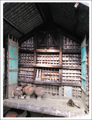
Sustainability of agriculture is the prime focus of IFS. Though fish–duck and cattle–poultry–fish integrated farming are in practice traditionally in the region, such farming with modern approach is making its presence known in Hatimuria village of Garukhuti and Dhalpur no. 2 of Sanoa GPs. The traditional knowledge and some age-old customs interwoven in farming life of some communities can contribute to sustainability. Unique paddy storing practices are quite common among the indigenous tribes and non-tribal communities of the study area. The most important storage structures for paddy seeds are bhoral (granary) and duli (cylindrical bamboo structure).
A granary is usually constructed as a permanent structure with a raised bamboo platform in front of the courtyard (Figure 3). Duli is portable and made of cylindrical bamboo structures that are 4–5 feet in height. Plastering of bamboo crevices of bhoral and duli with cow dung and mustard oil cakes inhibits the entry of pest and pathogens (Kumar et al. 2009). Topa is also a cylindrical bamboo structure of 1.5 feet height, especially used for preserving seed for paddy seedling.
Prospect Assessment of Agricultural Sustainability
In this investigation, the main aim was to assess the prospects of agricultural sustainability based on the previously mentioned six indicators. Thereby a scientific probe into the area exhibits its facets of strength and weakness. By synthesising the selected six indicators, three categories of GPs have been identified as follows.
First, Bajana Pathar, Sanoa and Garukhuti GPs are categorised in the first category as having high prospect of agricultural sustainability in the circle. These three GPs stretching over charland and its adjoining areas lie in high crop productivity zone. NIM community, OBC (Yogis) and IM community are predominant in this belt. Though these are chronically flood-affected areas of Darrang district, a well-adapted agro-ecosystem and pro-farming social milieu have developed here over time. The farming community of this physiographical unit follow a rhythm of the floodplain ecology. Autumn and spring rice, maize, jute and vegetables are the first rank crop combination of this belt. Currently, maize cultivation has gained popularity among farmers of this class of GPs due to its growing demand in market. It is evident that castes and communities of high productivity zone show much concern about putting in high agriculture input in farming. This zone of charland, along with its neighbourhood, experiences the effects of some positive factors of agro-ecological conditions. Rejuvenation of soil with yearly silt in agro-ecosystem, innovative sustainable methods and pro-farming sociocultural milieu are some of the potent positive factors influencing the whole farming system in this belt. The charland farming community is well accustomed to low and moderate flood. The yearly flood silt in charland and adjoining areas naturally rejuvenates the farmland and, thus, keeps input cost low to some extent in Hatimuria (Garukhuti GP), Phuhuratali (Bajana Pathar GP) and Dhalpur No.2, Dhalpur No.3 village (Sanoa GP). Frequent heavy floods and resultant breaching of embankments are matters of great concern in the area.
The second category of GPs that have potential for agricultural sustainability mostly lie in built-up physical unit. Hazarikapara, Bordoulguri, Lokrai, Ghorabandha, Sipajhar and Debananda GPs of this belt are the ones that have great significance from ecological, social and economic dimensions of sustainability. The farming communities of this region mostly belong to different castes of Indigenous Non-Tribal Hindu and IM communities. They have a very long history of settled agriculture in built-up physical unit. In this medium to high medium crop productivity zone, the age-old tradition of rice cultivation and other allied activities are deeply rooted in the culture of indigenous Assamese society. The farming communities of this category are largely organic farmers by default. Winter (sali and bao), spring and autumn rice varieties with mustard form the first rank crop combination. This category of GPs has been preserving indigenous rice varieties, namely boni, joha and bao (flood-resistant variety) from time immemorial. The orchard of areca nut and leaves (tamul or supari-pan) along with other fruit-bearing trees bear a promising future for young farmers. Along with paddy cultivation, upgradation of traditional allied activities will boost up the agricultural sustainability of the area. The traditional khowri custom, an age-old practice, has been quite prevalent in this category of GPs. It refers to a practice of providing community support to farmers from tilling, planting to harvesting. Such intra-community bonding can surely maximise the cooperation of farm families and minimise the considerable farm expenditure which is worthy of replication in other farming areas.
The third category with prospect of agricultural sustainability consists of Ganesh Kuwari and Kuruwa GPs of south-western part of the circle stretching over the physical unit of low-lying areas with low hills. These areas have great potentialities for rice cultivation, especially spring rice (boro) cultivation in marshy low-lying areas. This medium to high crop productivity zone has high concentration of Nepali, ST (Bodo), SC (Hira) and HC (Kalita and Keot) farmers. As for allied activities, cattle rearing and dairy farming of Nepali community in low hilly areas of Ganesh Kuwari GP have promising prospect of sustainability. The other important allied activities are pottery making of Hira community of Ganesh Kuwari who make use of a unique black soil found only in these hilly areas. The low marshy land of Ganesh Kuwari has great potentiality of integrated farming of wet rice-fish farming.
The other group of GPs being left out of the above three categories consist of Dumunichowki, Byaspara and Maroi GPs. These three GPs are designated as having least prospect of agricultural sustainability in present space and time context. There are some persistent problems inflicting the area, that is, out-migration of youths, conversion of farmland into settlement, caste system, ageing farmers, water scarcity in field, flood induced by Bengnoi river in Byaspara and embankment breaching by Nonoi river in Dumunichowki GPs and consequent sand deposition in crop fields. It demonstrates that the big farm families belonging to Ganak and Brahmin are unable to fully utilise their farmlands due to scarcity of land tenants. Hence, it needs upliftment in tenant–owner relations as well. However, some marginal farmers are backing away from farming activities as they are complacent with free government supplied rice. A holistic and integrated approach in planning is, therefore, essential to tackle these problems.
There is a pressing need for canal irrigation in northern part of the circle. The region has three major river channels, namely Barnadi, Nanoi, Saktola and a rivulet, Bengnoi flowing from north to Brahmaputra River in the south, but these resources have immense potentialities to be used for agricultural purposes. Sharma (2018) puts forward that farmers of Northeast India will be greatly benefited by bringing into effect participatory irrigation management in command area. Such water management schemes must ensure sustainable canal irrigation through active involvement of farming communities.
The present study proves that the agro-ecological conditions of the circle are on the verge of negative change due to population pressure. The southern and south-western part of it possesses diverse geo-ecological conditions comprising of the marshy area with low hills, grassland, scrub forest, water body and sandy area. These components of ecological conditions have registered negative net changes over the last 22 years. However, some plots of agricultural land have been transforming into non-agricultural use for years; for instance, small farmers of Ganesh Kuwari GP have become prey to the owners of brick kiln industry, and they have started selling out their smallholding to them. Twenty-two brick kiln industries concentrated in this area are the evidence of it. It can be visualised that if the proposed bridge between Kuruwa of Darrang district and Kamrup Metro materialises in near future, the area would bear the brunt of urban sprawl of latter, if proper assessment of the area is not accomplished. Therefore, it is high time to maintain the agro-ecological landscape intact for its sustainability.
Conclusion
The prime concern of this article lies in providing a base for assessment of prospects in agricultural sustainability. As regional approach brings to the fore the internal conditions of micro areas of study, it relates to a general study of the considerably larger areas. The micro-region, Sipajhar revenue circle set a unique example in assessing prospects of agricultural sustainability in central Brahmaputra floodplain. Study of this micro-region holds great significance in the context of replicating it in other meso-regions like lower and upper Brahmaputra plain in particular and macro-regions consisting of the whole Brahmaputra, Barak and Tripura plain of Northeast India in general. Thus, this approach provides a rationale for future orientation of agricultural planning.
The three categories of GPs identified in the circle hold great significance in the context of agricultural sustainability of the region. The agro-ecological conditions of these GPs are in a vulnerable state due to prolonged population pressure in the circle. The study puts forward the following suggestions based on foregoing synthesis of indicators.
First, there is an inescapable need for separate planning strategy for farmers belonging to different castes and communities of the area. Agriculture and its allied activities of communities urgently need upliftment through linking up with micro, small and medium enterprises. The circle has immense potential for integrated farming and horticulture to boost up rural economy. Farming communities are the de facto managers of their field. The impoverished farming communities of the circle suffer from shortage of capital to introduce any transformation in agriculture. Therefore, the farmer’s schemes should reach in full measure only to the man behind the plough.
Second, the revenue circle has been undergoing persistent problems of heavy flood and lack of irrigation. Total elimination of flood is not a viable proposition; at best, it can be controlled or moderated. Therefore, long-term measures through watershed management along with ad hoc measures should be included in planning strategies for flood management. The canal irrigational facility in the circle is practically absent despite being flanked by three major perennial rivers. This water resource can be turned into asset through participatory irrigation management and planning.
Third, it is to be noted that in general, the farming practices of the circle are still based on organic cultivation. The traditional knowledge and some age-old customs interwoven in farming life of some communities already have sustainable edge. As every farmer has his skill and resourcefulness, there should be more incentive and inter-community exchange of such ideas in reality. Hence, a holistic perspective in planning needs to be incorporated to boost up not only the economy but also ensure a sustainable mode of life.
Finally, it is concluded that the vision of self-reliant India comes true only through self-reliant villages, and therefore, Gandhiji rightly said ‘If the villages perish, India will perish too’.
Footnotes
Declaration of Conflicting Interests
The authors declared no potential conflicts of interest with respect to the research, authorship and/or publication of this article.
Funding
The authors received no financial support for the research, authorship and/or publication of this article.