
Abstract
In this article, I explore the complex trajectory of two bridges that were proposed for construction across the River Tungabhadra in the early 1990s at locations that now fall within the boundary of Hampi, a UNESCO Cultural World Heritage Site (WHS) in India. The proposed bridges were considered improper forms of infrastructure development in the visual context of a WHS, and the site was placed on the World Heritage in Danger List in the late 1990s. Popular media framed the controversy as a ‘classic clash’ between heritage and development where conservation goals and developmental needs opposed one another. Heritage experts, agencies, and activists read the crisis as one of ‘heritage or development’, normatively typecasting residents north of the river as ‘uneducated, ignorant locals’ wanting development at the cost of heritage. However, drawing on ethnographic fieldwork and archival material covering nearly three decades, I demonstrate that residents wanted the bridges not as physical infrastructure towards some obscure development goals, but as the means to link their overlooked contributions to the founding of the Vijayanagara Empire, the capital region and its contemporary remaking as a WHS. In this instance, the binary opposition lay in the ‘expert gaze’, not in local discourses. It was experts, rather than ‘local people’, who saw conservation and development as inherently opposed to each other. I explicate how various views on what constitutes heritage and development intersect with each other, and suggest that dissonance need not be the inevitable result but may be built into the gaze of expertise.
In this article, drawing on ethnographic narratives and textual and archival material, I examine the complex trajectory of two bridges that were proposed to be built across River Tungabhadra, at locations that currently fall well within the boundary of Hampi, the eponymous UNESCO Cultural World Heritage Site (WHS) in Karnataka, India. Heritage experts considered the project to be an improper form of development in the visual context of a WHS. They read the episode as yet another clash between heritage and development, which led to the site being placed on the WHS in Danger List. However, I demonstrate that resident communities, particularly those living north of the river, wanted the bridges not as physical infrastructure to achieve some obscure development goals; rather, they wanted them as a way to gain official recognition of their equally ‘glorious’ yet overlooked history and significant contributions to the Vijayanagara Empire’s capital region and its contemporary making as World Heritage. Building on critiques of development discourse, I argue that the binary opposition between conservation and development lay in the ‘expert gaze’ and not in local discourses. It was heritage experts, enthusiasts, and authorities, rather than local people, who saw conservation and development as inherently opposed to one another, leading to a lengthy stand-off.
The situation came to be understood as a ‘crisis of development’ because it was read through the lens of ‘official’ 1 heritage, which divided the actor-scape into a simple binary of ‘us’ (pro-heritage, anti-development) and ‘them’ (anti-heritage, pro-development). Further, the expert gaze read the crisis purely as a consequence of insufficient planning in implementing a regional infrastructure development project, accompanied by inadequate site management strategies. For them, the crisis demonstrated how politics, ‘external’ to conservation goals, tend to affect outcomes. I argue that such ‘technical’ reasons, though partially correct, represented simplistic normative readings of a more ambivalent and enmeshed reality.
I build on various vignettes from my fieldwork to show that, for residents, the materiality of the bridges represented heritage—a means to look back from the present to a glorious though ‘imagined’ past and look forward to a legitimized ‘imaginary future’ (Graham et al., 2000). I show that the narrow gaze of expertise was neither able to comprehend peoples’ hopes and aspirations nor account for the complex sociocultural dynamics of the site; instead, the gaze simply read residents on the north side of the river as ‘local people’, a category of stakeholders who are popularly deemed insensitive and/or indifferent to (official) heritage and in dire need of heritage education. Ultimately, it was official heritage and expertise that benefitted from the crisis, rather than local people, in whose name the bridges were proposed and, in the contemporary moment, (official) heritage tends to be identified, managed, and developed—at Hampi and elsewhere.
Critiquing the Expert Gaze
I commenced structured academic research through the lens of practice to understand if ‘dissonance’ (Tunbridge & Ashworth, 1996) was inevitable when official heritage trajectories intersect with peoples’ lives. Elsewhere, I have argued that dissonance at Hampi WHS arose out of care rather than apathy. In my research, I found that all social actors, whether practitioners, heritage enthusiasts, heritage agencies, or local people, demonstrate care for heritage, but this often went unrecognized by the ‘other’ (Rajangam, 2019). Here, I continue this line of critical inquiry and suggest that dissonance also arose because it was built into the gaze of expertise through the discourse of ‘development’.
I aim to contribute to the growing body of critical literature that examines the role of heritage expertise in (unintentionally) reproducing unequal structures of society through everyday mechanisms of conservation management. This scholarship has traced a history of heritage expertise to ‘Western hegemonic’ models (Byrne, 1991) which, in some instances, become the means for experts (as archaeologists) to continue practicing ‘un-hindered’ (Meskell, 2011; Smith, 2004). Elsewhere, the expert gaze works as a state mechanism to regulate and order society (De Cesari & Herzfeld, 2015). Several of these critical scholars have ‘studied up’, for instance, by undertaking ethnography of UNESCO WH Committee meetings and expert (ICOMOS) 2 deliberations (Meskell, 2012, 2014) to direct attention to how seemingly external politics affect heritage-making outcomes. Others have studied ‘Us’ rather than ‘Them’ 3 (Brumann, 2014; Byrne, 2008), that is, what ‘we’ as conservation experts do when we seek community participation or pronounce judgements on heritage and its conservation.
Some of this scholarship has directed attention to the everyday mechanisms of conservation management in specific contexts, and has either examined everyday practice as an act of value judgement undertaken by experts (Jones & Yarrow, 2013) or presented a social critique by foregrounding the everyday consequences of such value judgements (Geary, 2017; Herzfeld, 2006, 2010; Yapp, 2018). Hardly any work has attempted to bridge these bodies of literature in ways that are mutually compatible. While recognizing that the discipline is ethical and reflexive about the mechanisms of practice, in this article, I attempt to highlight some of the structural issues that shape everyday practice.
Critical conservation scholarship has reflected on the inter-subjective nature of everyday practice. Munoz-Vinas (2017) and Zancheti and Hidaka (2016) examined its roots in ‘scientific rationality’ (Winter, 2013a, 2013b) and suggested that the role of expertise needs to change, based on the shifting (wider, more democratic) nature of heritage (Schofield, 2014). Such work has also examined the reluctance of experts to own up to the subjectivity inherent in practice instead of reading problems as a personal failure to apply scientific method (Munoz-Vinas, 2017).
Based on empirical experience, Byrne (2008) further suggests that the reluctance of practitioners to examine the politics of heritage and conservation arises from a tendency to naturalize one’s work as fulfilling an obvious need rather than actually producing heritage. Although conservation practice seeks to democratize heritage making, management, and development through people’s participation, it remains caught in the binary trap of seeing the standpoints of local people as subjective and the stance of expertise as objective (Jones, 2017). Consequently, politics tends to be understood as external to technical matters of conservation.
Given that the bridge crisis was read as one of development versus conservation, I build on Mitchell’s (2002) and Li’s (2011, 2014) critiques of development projects to explicate the gaze of the expert that seeks ways to step in and ‘solve problems’. Local government officials, heritage experts, and NGOs of Hampi WHS exhibit a ‘will to improve [society]’ by rendering societal problems technical (Li, 2011, 2014). I also find Appadurai’s (2013) work on culture as aspiration, which explicates how culture has come to be linked with the past and development with the future, useful in historicizing the binary division of culture and development.
I bring these bodies of literature together to argue that the gaze of expertise in this case reduced local people’s concerns (particularly those of residents north of the river) to mere aspiration for development (understood as economic and infrastructural improvement), whereas their motivation was a desire to be included in the official (and wider), historical, and cultural narrative of Hampi region as a WHS. Most actors in the Hampi site understood the word ‘development’ to mean economic growth, although, as I demonstrate through this article, they employed it in diverse ways.
In the following section, I briefly describe the site to foreground its image as constituted purely by ancient ruins of the past. I then present a chronology of the bridge project, viewed as a crisis of development. I also touch on the politics around the project which I recognize as a contested, contingent process whose effects maybe long-lasting. Finally, I examine narratives of residents and experts and situate the analyses within critical scholarship on expertise, development, and people (as intended beneficiaries) discussed above.
The ‘Monumental and Iconic’ Hampi World Heritage Site
The UNESCO Cultural WHS of Hampi in Bellary district, Karnataka, South India encompasses the capital region of the medieval Vijayanagara Empire. One of the early Cultural WHSs of the country, it was inscribed in 1986 as ‘Group of Monuments at Hampi’ along with ‘Churches and Convents of Goa’, ‘Fatehpur Sikri’, and ‘Khajuraho Group of Monuments’. The site is located in a rocky, cultivated landscape intersected by a river. The widespread remains of the capital city are interspersed by settlements, revenue villages, agricultural fields, and plantations. The remains include ruins, archaeological mounds, fortifications, palace complexes, temples, and water systems, which lay across a series of valleys intersected by rocky hill ranges. The ‘spectacular setting’ (UNESCO, n.d.) of the site is dominated by the River Tungabhadra which flows through the site’s core.
The current site boundary encompasses an area of 236 km 2 , including a core of approximately 40 km 2 . The principal ruins and monuments within it (56 in number) are protected nationally by the Archaeological Survey of India (ASI) of the Government of India (GOI), while regionally the Department of Archaeology, Monuments, and Heritage (DAMH), Government of Karnataka (GoK) protects over 1200 diverse remains. Site conservation management consists of a layering of regional, national, and international mechanisms co-ordinated by Hampi World Heritage Area Management Authority (HWHAMA) as the nodal agency—the first such organization in the country.
The site is considered ‘[an] outstanding archaeological site of Hindu Asia [and] the most completely preserved medieval Hindu capital in India…to European travellers in the fifteenth and sixteenth centuries, the [capital] city seemed enormous and magnificent’ (Fritz et al., 1986, pp. 22, 25). It would be appropriate to label the site as Karnataka’s poster child for culture, a way to showcase the state’s ancient and glorious history. The Stone Chariot of the Vithala temple complex, the Raja Gopuram (main tower) of Virupaksha temple (both major attractions on site), and the rocky landscape often feature prominently in Karnataka state’s publicity and tourism materials. Diverse promotional campaigns invite one to repose at Hampi, ‘the site of the magnificent and glorious kingdom of Vijayanagara’ (Times of India, 2016, p. 9). The Golden Chariot—the state’s luxury train service—makes a protracted halt at Hampi and is named after the stone chariot. Local events in the region regularly reference the site’s association with the Vijayanagara period; for instance, a hoarding put up on the site to announce the birthday of the region’s elected representative (MLA, or Member of the Legislative Assembly) likened him to the iconic Vijayanagara ruler, Krishnadevaraya, while the wedding pavilion of a political leader’s daughter was constructed in imitation of Vithala temple’s mantapas (pillared halls) (Swamy, 2016).
The core zone is not comprised exclusively of monumental ruins, but it also encompasses four villages: Kamalapura (now a town), Kaddirampura, Hampi, located on the southern banks of the River Tungabhadra, and Anegondi on the northern bank. Over 30,000 people call these settlements home. Hampi and Anegondi are located by the riverside, while Kaddirampura and Kamalapura are situated farther away. In addition to these four settlements, the core zone includes a small land parcel with houses and fields called Virupapura Gaddi, located on a riverine island just north of Hampi, near the Virupaksha temple complex. It is accessed by one of two historical fording points, especially the one located just north of Virupaksha temple, called the Virupaksha Ghats. The other fording point is located north-east of the ruined Vithala temple complex and is called the Talwarghatta crossing. It leads to Anegondi (see Figure 1).
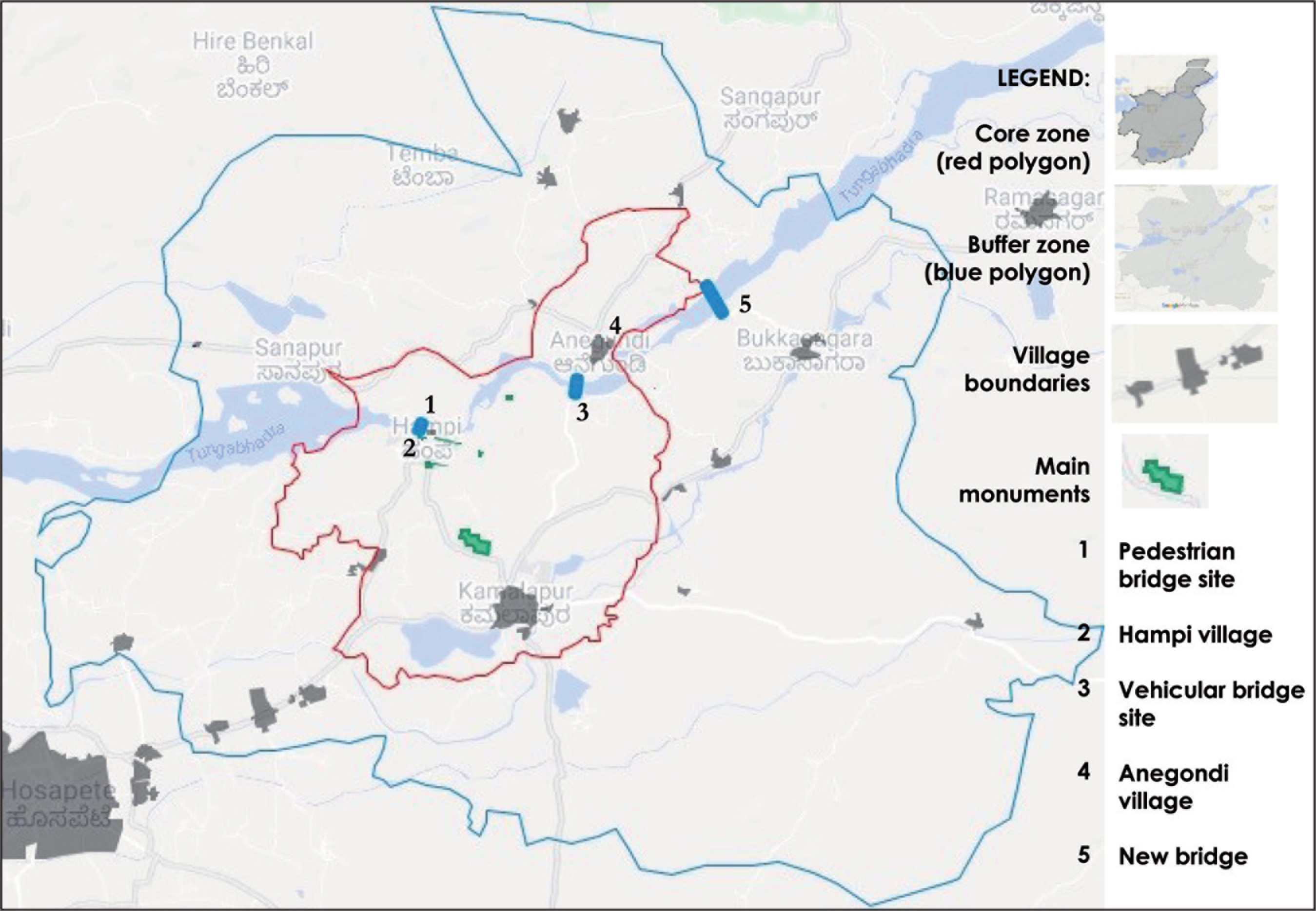
In the past, crossings were typically made using coracles (a round wickerwork boat), which have since been replaced by motorized boats. Usage restrictions, however, remain the same—they are operational only during daylight hours, depending on local currents, with limited manoeuvrability due to the rocky nature of the river bed. This made everyday commuting between the two banks of the river difficult. Finally, in the 1990s, with the support of political leaders on the northern side, the local government proposed to construct bridges at both fords so that people could cross the river unrestricted. At that point, the proposed bridges were seen as a regional infrastructure project independent of the nearby monumental site representing the material heritage of the Vijayanagara period. Moreover, the bridges were planned at locations beyond what was then the boundary of WHS.
Bridges as Visual Aesthetic Crisis 4
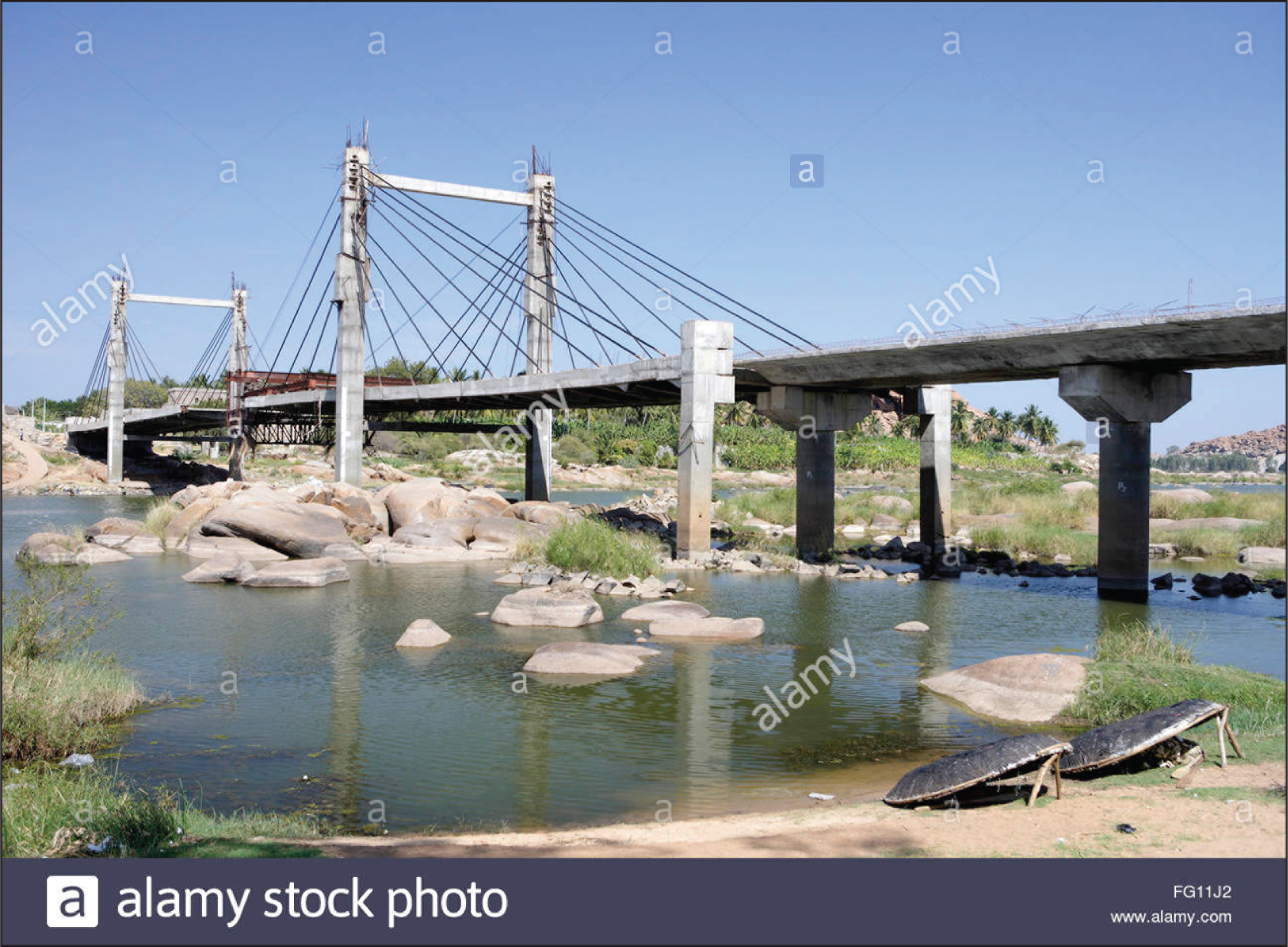
In 1993, foundation stones were laid to construct a footbridge between Hampi and Virupapura Gaddi and a vehicular bridge at Anegondi Talwarghatta ford. The footbridge was nearing completion, and the vehicular bridge was about 70 percent complete when a UNESCO WH mission visiting the site noticed the bridges and raised objections to them (probably in 1997). The team considered the construction detrimental to the authenticity and integrity of the site—two tenets that are considered integral to maintaining the Outstanding Universal Value (OUV) of WHS. Authenticity is defined as the ‘truthful and credible expression’ of a property’s cultural values, whether of design, material, workmanship, or setting, while integrity is defined as the ‘intactness or completeness’ of a site’s attributes (UNESCO, 2008). The primary objection of the mission was that the bridges were completely out of context to their setting, in terms of both scale and design (see Figures 2 and 3). The footbridge, planned as a suspension bridge, had pylons taller than the Raja Gopuram of the Virupaksha temple complex. It was clear that the bridge at Anegondi, a cable stay bridge with concrete pylons, was not meant exclusively for smaller vehicles but for heavy goods traffic as well. 5 In effect, I suggest that the crisis was over visual aesthetics.
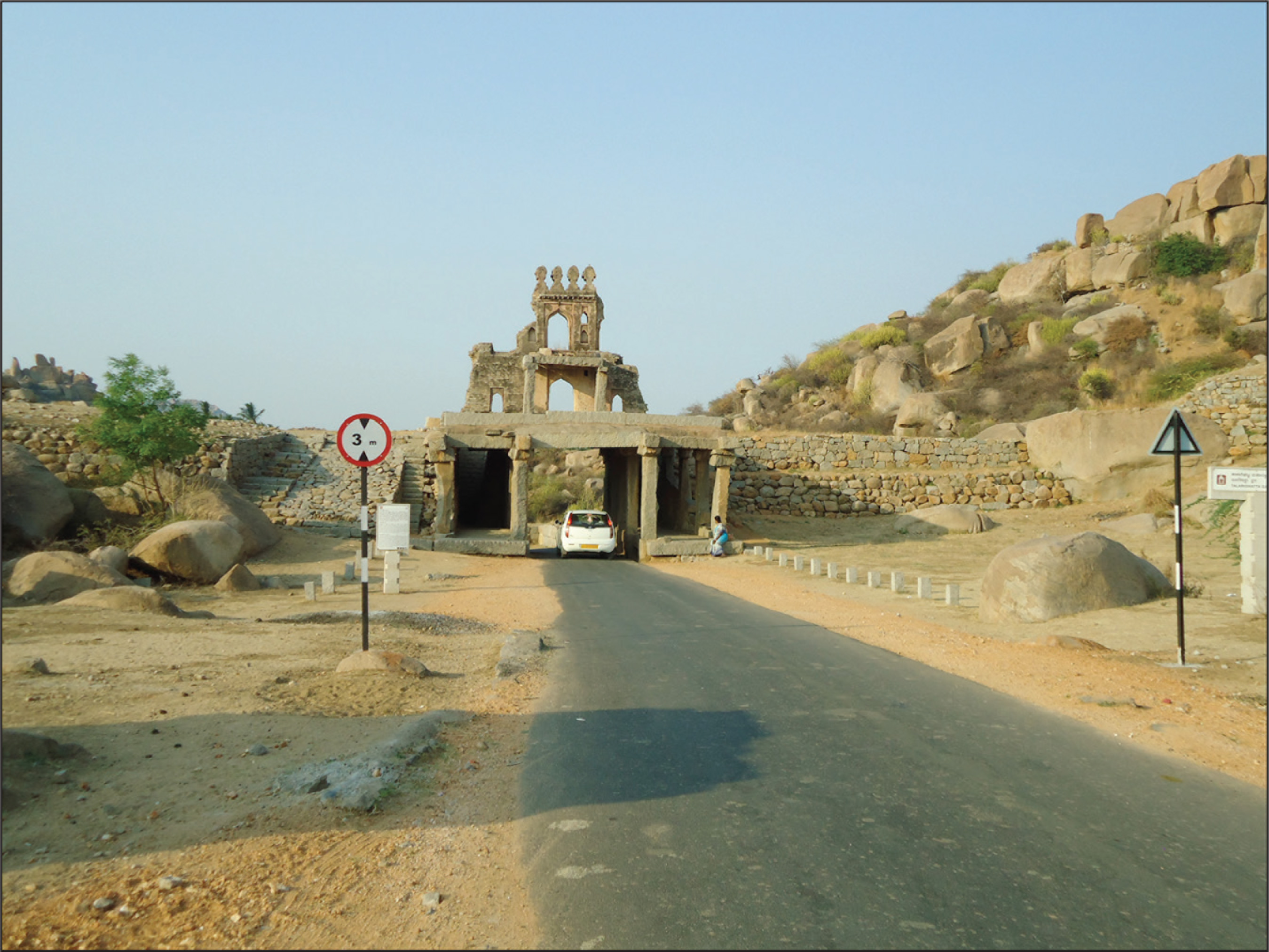
On the southern side, the road leading to the vehicular bridge would have to pass through the historic Talwarghatta Gate (part of the fortifications around the medieval capital). The gateway was not wide enough to accommodate the proposed carriageway, and so, it was proposed to be dismantled (see Figure 4). On the northern side, a historic river gate had already been dismantled to make room for the wider carriageway.

Subsequently, in 1999, the Hampi site was placed on the list of WHSs in Danger based on a vote at the annual General Assembly of the WH Committee. Based on further UNESCO missions, and at the behest of the central government, in October 2000, the Government of Karnataka (GoK) passed an order to dismantle and relocate the footbridge as a compromise. This was seen as a way to deal with the issue expeditiously. In response, a group of private citizens filed a petition (petition 1) 6 with the High Court requesting that the GoK order be set aside and work on both bridges completed. Subsequently, a counter petition (petition 2) was filed by another group supporting the government order, requesting that the first petition be set aside. Petition 1 (pro-bridge) argued that the vehicular bridge was nearing completion, and that it had presumably gone through a process of validation, and hence, it would be a double waste of public money to demolish a nearly complete bridge. Petition 2 (anti-bridge) argued that the bridges should be dismantled in keeping with UNESCO WH Committee and ICOMOS (expert body advising UNESCO WH Committee) recommendations. The court took up both petitions together, and in its order of September 2001 ruled that no further action should be taken until a Hampi authority was constituted to look into the matter. 7
This authority, HWHAMA, was finally constituted in 2002 by order of the GoK. Subsequently, in 2003, the Public Works Department (PWD, which had awarded the bridge contracts), passed an order approving bridge completion, based on inputs from HWHAMA and a State Level Advisory Committee (set up to deal with the crisis). 8 Subsequently, the Petition 2 (anti-bridge) group filed another petition (Petition 3) to quash the PWD order, arguing that it was against public interest and the ambience of Hampi. They argued that, first, a distance of 1 km from the edge of the site boundary was to be protected in partial implementation of UNESCO recommendations and that the vehicular bridge was less than 1 km from Vithala temple complex. Second, in July 2000, a Government of India (GoI) observer had submitted to UNESCO that bridge construction had been halted and corrective measures would be taken. Third, a UNESCO and ICOMOS joint mission, in February 2000, had recommended the relocation of both bridges. A GoK task force had made a similar recommendation, which had been accepted during a cabinet meeting. The response of the state government was that the PWD order was not illegal; it was issued after consulting UNESCO and other experts, including HWHAMA. The High Court dismissed Petition 3 (anti-bridge) saying it was neither in public interest nor was it correct to state that GoK had not consulted experts, since HWHAMA was presumably one such expert body.
While the sequence of events between 2003 and 2006 remain a bit hazy, it was clear that a compromise had been reached. In 2006, the WH Committee voted to remove Hampi from the Danger List based on the assurance of GoI that the footbridge would be dismantled, a single carriage vehicular bridge would be completed at Talwarghatta as a temporary measure, and another site further downstream would be chosen for a permanent vehicular bridge. In January 2009, just weeks after construction recommenced on the remaining segments of the Talwarghatta Bridge, its partially complete portions collapsed into the river. 9 Over the next few weeks, debris was removed and bridge construction at that location abandoned. By 2015, work on a new vehicular bridge, about one km downstream from Anegondi, was well underway. The location was chosen based on inputs from landscape consultants and was opened to public in November 2016 (Figure 5).

As the sequence of events suggest, the trajectory of bridge construction was neither simple nor straightforward. I now offer my analysis of the chronology by drawing on diverse narratives and vignettes, to direct attention to the complex sociocultural dynamics of the field site and examine how these relationships of power are connected to the bridge project.
Bridge Politics and Local Concerns
Official documentation records a need for the bridges at the site since the 1980s. However, an elderly long-term land-owning resident of Anegondi village, observed that such a demand had been in place since before independence:
But when it was finally cleared it was so the local MLA would benefit and not really keeping peoples’ needs in mind. He had a resort outside of Anegondi [located between Anegondi and Virupapura] and wanted better access to it, so he was keen to push for bridges at both fords.
Many residents on either side of the river mentioned the MLA’s ‘vested interest’ and set out similar reasons for bridge construction being stalled and for the collapse as well:
The Hosapete [nearest city to the south with rail access] hotel lobby [at that time led by the MLA on the southern side] did not want the Anegondi Bridge, because then hotels would start coming up to the north, at Gangawati [nearest town on the north with rail access]. They didn’t want that. They interfered and made sure work was stalled for many years. You tell me, how come a bridge that was standing for so many, many years collapsed so suddenly into the river?
A former resident of Hampi and current resident of Kamalapura, who now works in the tourism sector, narrated:
I saw them dismantle the pylons of Virupapura hanging bridge. They poured some chemical on the base and it collapsed gradually– it took about two days. How come the Anegondi Bridge collapsed so quickly, almost like it had been neatly cut? Later when they came to dismantle the fallen bridge, it took them days, using chemicals and cutters…And the day the bridge collapsed, only our people [local labour] reported for duty, the rest [migrant labour] stayed away. They must have known something was up. Only our people lost lives…
Many others shared similar views on the politics of the project. However, one aspect that stood out amidst the various narratives was that construction would probably not have been halted had the designs been less obtrusive. A UNESCO WH official said, ‘A pedestrian bridge with supporting pylons taller than Virupaksha Gopuram, how could one allow that? Have you seen pictures of the vehicular bridge; it was more suited to an expressway than a WH site!’ Similarly, most experts involved with the site in various ways agreed that a bridge would benefit the movement of people, but ‘the ones under construction were completely out of scale of their setting’. The elderly Anegondi resident informed me that the original design was indeed different:
[It was] more like a regular bridge, till [somebody] in PWD got the bright idea to make the first cable stayed bridge of Karnataka. Maybe he thought it would become a tourist spot, much like the ruins of Hampi, or maybe it was to ensure cost escalation. After all, the Rs. 2.5 crore project did become a Rs. 4.5 crore one after the design was changed.
Experts familiar with the site also mentioned the altered design and cost escalation as factors contributing to the crisis. It was a Vijayanagara scholar and heritage enthusiast who proved to be the catalyst. During our interview, the scholar remarked:
I happened to visit the site and noticed the bridges and asked myself, what is this nonsense? With the help of other experts [architects], I sent a report to UNESCO—till then they were unaware of the bridges! People warned me that I would lose my life as the bridges were meant to facilitate drug trafficking…but I stood firm.
While such explanations, ranging from people movement to drug trafficking, may have weighed into the decision to build the bridges, a persistent narrative (which I see as predominant) was that voiced by residents. Based on their observations and remarks, I argue below that for local people, particularly those living north of the river, the bridges were the means to ensure wider recognition of their historical contribution to the making of the Vijayanagara Empire and were not only about easing the local commute.
‘It’s all Hampi, Hampi, Hampi…the rest of us are completely ignored.’ This was the opening remark of a conversation I had with a core zone resident, one that I heard often. Most residents of the core zone felt side-lined by the site’s visitors and local government. After the WHS became a promotional brand for the state, Hampi village (located at the centre of the site) was inevitably spotlighted and not for its betterment (as I have argued elsewhere; Rajangam, 2020). Anegondi residents in particular felt extremely bitter: a family of three brothers, who grew up in Anegondi and have since relocated elsewhere, remarked, ‘Actually, we asked to meet you because we were curious to know who this person was who wanted to talk to the residents of Anegondi, we have always been ignored!’ Residents considered the separation between WHS and their village ahistorical, acultural, and asocial. It was ahistorical because the bulk of casual visitors to the site remained unaware of Anegondi and inevitably restricted their ‘sight-seeing’ to the south of the river, to the Virupaksha temple, the Royal Enclosure or the Vithala temple complex. One evening, I was walking from Talwarghatta ford towards Vithala complex and the main access road, back to Hampi and other south bank villages when a group of tourists exiting the complex stopped me to enquire if the path led anywhere ‘worth seeing’. They wished to reassure themselves that they had not missed any significant parts of WHS. When I explained about Anegondi, the group expressed amazement at not hearing of the place, though this was their second visit to the site. Anegondi residents were particularly frustrated over the continued neglect of their existence in popular consciousness—the Vijayanagara dynasty was founded there and the capital subsequently shifted south of the river. There is consensus among historians that Anegondi could be deemed the originary of the medieval empire (Tobert, 2000). The founder of a local cultural NGO remarked:
When I first visited Hampi many, many years ago, I was struck by how modern it looked. This surprised me as I knew Vijayanagara Capital Region was a historic landscape, so it must have had some ancient settlements and I asked myself what happened to them. Finally, a professor directed me to Anegondi, with its still intact walls and gateway, ancient temple, traditional vernacular houses…it looked exactly like I had imagined such a historic landscape would be like, and that’s how I ended up setting base in the region.
Unlike Hampi village, not only was Anegondi ancient, but it also looked ancient, an aspect of some importance to the NGO founder. However, residents focused more on shared (living) culture, in terms of language(s), customs, traditions, shrines, and rituals, rather than just a common visual (material monumental) past. As the brothers from Anegondi passionately narrated, ‘We are part of Hampi and always have been. From the high rocks just outside our village we could see Vithala temple complex and still can, it’s always been close by…this separation is false, it has been created’. For instance, the annual Ranganatha Jathre (a procession of Anegondi’s tutelary deity) is bound with that of Virupaksha (Hampi and Vijayanagara’s tutelary deity) and takes place a week after Hampi Jathre. The latter is the principal religious festival of the region, attracting thousands of pilgrims from all around the WHS, as the empire encompassed regions either side of the river. The colonial administration saw Tungabhadra as a natural political barrier and deemed areas south of the river as the edge of Madras Presidency, a British administered territory, and north as part of the semi-independent dominions of the Nizam of Hyderabad. Several years after Indian independence, when the linguistic state of Karnataka was carved out of parts of Madras Presidency and the Nizam’s territories (among other administrative divisions), Hampi, Anegondi, and other villages situated either side of the river were incorporated into Karnataka. Colonial administrative boundaries, however, persisted, for Anegondi was designated part of Karnataka’s Koppal district,
10
while Hampi and other southern villages were incorporated into Bellary district. For residents, this creates problems even today. The elderly Anegondi resident remarked during another conversation:
When the Bellary district minister proposed Hampi Utsav [festival] to celebrate Hampi’s glorious history and cultural legacy, Anegondi was left out because it came under a different administrative boundary. We demanded Utsav at Anegondi too, after all, weren’t we part of the same kingdom? But when Anegondi Utsav finally took shape, it was announced as an independent festival. It was neither as well-planned nor as well-promoted as the Hampi one, nor held as regularly. It doesn’t have as much budget allocation as well.
Besides a continued feeling of being ignored, the categorization as WHS further altered the sociocultural dynamics of the region. I often heard Anegondi residents make remarks such as:
No attention is paid this side of the river; all funds are allotted only to the south side, nothing to us. So many tourists come to Hampi, but very few come here. Recently numbers have gone up, but still if the bridge had been built then everyone from Hampi would have come here and our village would have benefited.
These remarks clarify that Anegondi residents were unhappy about the lower numbers of tourists visiting their village compared to Hampi. In addition to possible economic benefits associated with tourism and/or development, most north side residents also mentioned that farmers would have benefitted if the vehicular bridge had been built—they would have been able to access the better-connected markets to the south and obtained better rates for their produce. However, farmers on both sides remarked that the north side predominantly produces paddy, while south grows sugarcane and bananas, which travel to completely different markets, making potential economic benefits to (unspecified) farmers an unlikely yet convenient developmental reason for bridge construction. Probably, these residents were just repeating the reasons they had been told when the bridges were first proposed by local political leaders. I further observed that unlike the straightforward explanation they offered about economic betterment (accessing wholesale markets), the north side residents were unable to clearly articulate any personal benefits due to tourism. For instance, I asked a resident of Anegondi to provide examples of what he considered developmental benefits of tourism, and he had to think about it for a while before hesitantly replying, ‘Well…there are no facilities for tourists here, no information on the place, its history, all the monuments here are neglected, forgotten…’
It would appear that the north side residents anticipated the bridges for historical reasons rather than tourism-related local development. I argue that Anegondi residents were laying claim not to any vague economic benefits in the future but to past ancient glory that, in their eyes, had wrongfully been attributed to Hampi village. Given that descendants of Vijayanagara royal lineage live in Anegondi to this day, reclaiming their forgotten contribution to Vijayanagara history was of some importance, especially since Hampi village was unable to claim a similar continuity. In addition, stretching their claims further back in time, parts of Anegondi village are identified with the mythological kingdom of Kishkinda (which plays a central role in the Ramayana). Although certain other parts of the site are also linked to events in the Ramayana, Hampi village is unable to make similar claims. A few Anegondi elders proudly narrated that ‘unlike Hampi, Anegondi is actually a spiritual place where Rama did tapas (ascetic practice), and it is not really meant for sight-seeing as such…’ Regardless of the accuracy of this account, to me, this statement suggests an attempt to make meaning of the fact that they had not obtained any tangible benefits of ‘development’ through tourism. Equating Hampi village with ‘mass tourism’ and ‘commercial development’ might be a way to see themselves as culturally more authentic and superior to Hampi village.
Gaze of Expertise
Experts familiar with the site were aware that residents of Anegondi (and to some extent other settlements on the north side of the river) felt neglected but considered their grievances trivial, attributing it to their inability to obtain any tourism-related economic benefits. While discussing the bridge crisis, a heritage practitioner rather sheepishly admitted (not only did he look embarrassed but the cause also appeared silly to him), ‘You won’t believe it but the whole bridge thing [construction/crisis] started with petty jealousy [between Hampi and Anegondi]…nothing more! Anegondi people felt left out. They thought only Hampi was benefitting’. It would appear that though the expert gaze was able to read diverse local interests in the bridges as subjective and instrumental, it was unable to recognize that its own standpoint was equally subjective—reducing power relations to vested interests or petty jealousy and agreeing that bridge construction would not have been halted had experts and enthusiasts considered the designs less obtrusive.
In the months leading to the collapse of the bridge (2007–2009), I participated in a series of workshops and seminars jointly conducted by UNESCO WH and ASI (and in some instances by GoK) at Hampi and elsewhere. The various meetings were meant to impart knowledge to diverse stakeholders of Indian WHSs on OUV, authenticity, integrity, core and buffer zones, uses and activities deemed in keeping with the WH setting, and so on. When news of the partially completed bridge’s collapse filtered in, a UNESCO official conducting one such workshop expressed delight over the crisis of visually improper development resolving itself, remarking that it was an act of God. I agreed with the official as I was solely donning the hat of conservation professional at that time, and saw the bridge as nothing more than unsightly public infrastructure in a heritage setting.
Similarly, as a professional, one could contend that ultimately, Anegondi and other residents north of the river did benefit from the crisis by finally gaining the official heritage recognition they desired. As part of the necessary remedial measures to ‘resolve the mess’ (paraphrasing experts and UNESCO officials), the site boundary was completely redefined between 2005 and 2007. As a result, many villages north of the river were included within the buffer zone while Anegondi was included in the core zone. To briefly recount the boundary realignment—when GoI first proposed that the Hampi site be included in the WH list (in 1982), Anegondi village was not part of the plan. This omission, among many other issues, was pointed out by the inspecting expert committee from ICOMOS. The team considered that the proposed boundary was ‘limited’ and ‘restricted to a few isolated though major monuments’, which was an ‘injustice to the site’ (ICOMOS, 1982). They recommended that Hampi’s inscription as a WHS be deferred until the boundary could be defined in a more comprehensive manner.
However, in 1986, when Hampi was voted through and inscribed to the WH list, none of these issues had been addressed and the boundary remained as proposed (see Figure 6). While the sequence of events is unclear, Meskell’s (2014) work on ‘politics of pacting’ at WH committee meetings offers a reasonable explanation for Hampi’s inscription and its removal from the Danger List in WH many years later, in spite of expert recommendations to the contrary in both instances. Based on ethnographic fieldwork at these meetings, she conclusively argues that it becomes possible to set aside expert recommendations on WH inscription and management processes, as diplomatic officials of different countries (such as belonging to the BRICS alliance) agree not to vote against each other in return for trade or other geopolitical agreements.

After its declaration as a WHS, visitor numbers gradually increased, as roads were laid and buses introduced. However, it appeared that nothing much changed, at least in the eyes of experts, until the bridge crisis offered a way to foreground heritage beyond isolated monuments. A retired civil servant who had worked in the Ministry of Culture, GoI, and sat on one of the many expert advisory committees formulated over the years to deal with issues related to Hampi’s site management, said:
One good point of the bridge issue was it made heritage a central concern—for the first time in India, heritage conservation became centre-page news! Imagine the opposite scenario, if no one had taken any notice and Talwarghatta gateway had been demolished…So many VIPs came to visit the site at that time to see what the fuss was all about.
An archaeologist familiar with the site echoed his viewpoint:
Till the issue of the bridges, UNESCO’s involvement or even a conservation agenda for the site was non-existent or extremely feeble. The pylons of the hanging bridge were taller than Virupaksha temple gopuram. At Talarighatta [Talwarghatta] crossing, they dismantled a monument on the north side —a gateway leading to Anegondi river bank. Nobody bothered about it or commented on it.
ASI saw no reason to take note of the projects, as the vehicular bridge was nearly 1 km away from their nearest protected monument (Vithala temple complex). At the other ford, Virupaksha temple complex was not protected by ASI at that time (it is now) but by Karnataka’s Department of Archaeology, Museums and Heritage (DAMH). DAMH did not respond because in their eyes the bridges were a necessary regional development project that did not affect their monuments per se. The retired civil servant further observed:
When it all blew up in everyone’s face [after Hampi was put on the Danger List] and accusations were flying back and forth, one key question being raised was how the bridge reached 40–50 percent completion without the heritage fellows raising a stink or even getting to know about it. Gram Panchayat or whoever gave permission to PWD. It was all routine, nobody thought twice about it—funds were allocated, bridges were sanctioned, works began, and that was that.
A former UNESCO official added another layer to the tangled chronology:
We didn’t really want Hampi on the Danger List, although you know having a site on the Danger List is not supposed to be a punishment or embarrassment but a process to help. My colleagues were right from their viewpoint—a bridge, whether for people or vehicles, on top of a mantapa and all is just not done and it was all to serve the interest of a local MLA. One of the Indian delegates at that time believed in the WH process, believed that debate on the issue would help the site; that it was ok for it to be put on the Danger List, and suggested that this was the only way to shake things up.
From these narratives, it would appear that heritage experts, officials, and enthusiasts, and not residents, welcomed the bridge crisis and were instrumental in the events that led to the lengthy stand-off. The Vijayanagara scholar drew the attention of UNESCO WHC to the bridges as improper development in a WH setting, and the Indian delegate—a heritage enthusiast—hinted that having Hampi on the Danger List would help the cause of heritage, a standpoint echoed by both the archaeologist and retired Ministry of Culture civil servant. The petitions mentioned earlier also in some way reflect the heritage–development divide in popular understanding (at least in the eyes of heritage experts and enthusiasts). Petition 1 (pro-bridge) noted the occupations of the petitioners as agriculturalists, shopkeepers, and the like, that is, local people who supposedly wanted the bridge built as a necessary regional developmental activity. Alternatively, Petitions 2 and 3 (anti-bridge) noted the occupations of the petitioners as historians, artists, film-makers, and the like who saw development as opposed to heritage. However, one Hampi scholar did comment on both peoples’ suffering and the ahistorical separation of north and south, while remarking that the bridge design was an ‘eyesore’:
Bridge location was ok as it was a traditional ford, though the architecture was an eyesore…but local people felt need for a bridge. They needed to transport goods. They felt the separation between north and south was against history. I felt compelled to intervene and issued a statement that the problem should be resolved at the earliest and it was too late to think about right or wrong. My reasoning was that at the end of the day, UNESCO recognition is just a certificate; local problems are best solved locally. Meanwhile people continue to suffer; they should not be left hanging.
The long wait has preyed on the minds of the people residing both sides of the river. When we were discussing the 20-year-long chronology of bridge construction, a boatman plying at Virupapura commented:
At least if some decision had been reached quickly, we could all have moved on with our lives instead of this waiting… If they had built the footbridge for example, then yes, we would have to look for jobs elsewhere, but we wouldn’t be living day-to-day. Forget our income, at least local people would have benefitted.
Another boatman at Chakra Tirtha (another river access point) summed up the saga in this way:
I was a boy when they started work on the [vehicular] bridge and for years I saw it lying incomplete, and finally it collapsed. They didn’t give proper bali (sacrifice) to the river, which was a mistake they made right at the beginning. That’s why the bridge was never completed. It was an ill-fated project from the start.
I interpret this and similar narratives as attempts to make sense of the sequence of events, including the long wait. For Anegondi residents, it signalled a collapse of their hopes and dreams that were pinned on the bridges, as a way to set right certain historic omissions, an argument I develop in the next section.
Binary Discourses of Heritage, Development, and Local Communities
In this section, I argue that for the north side residents, the bridge as a material object did not stand for either development as infrastructure or development as undefined benefits from tourism, but heritage. I then explicate the binary of ‘us’ and ‘them’ that frames the views of other social actors, particularly heritage experts and enthusiasts.
It is clear from resident narratives that local people, particularly Anegondi residents, attributed meanings to the materiality of the bridges, which not only reached back in time from the present to connect to their Vijayanagara period of history but also forward in time in anticipation that their historical omission from the WHS would be rectified. That is, the narratives were centred on the temporal and material, two attributes that (ironically) are central to the concept of heritage. 11 I suggest that for the north side residents, the bridges were a metaphor for heritage and the bridges connected them to a material past that was imagined and a future that proved equally imaginary (Graham et al., 2000). I elaborate this argument below.
In the ‘now’ (contemporary moment), Anegondi residents regret their more recent inclusion in WHS (when the boundary was redrawn between 2005 and 2007), not only because they are unable to obtain any tangible benefits from tourism but also because negotiating daily life has become trickier. Rather than the site’s official heritage ascription being in need of diligent, participatory governance (paraphrased from various UNESCO reports), official heritage governs the site’s residents (Rajangam, 2020). In the name of community engagement through local development, everyday site conservation management processes have enabled the creation of a ‘heritage regime’ (Bendix et al., 2012; Geismar, 2015) that constantly regulates the lives of local people. The regime takes the form of a ‘bureaucracy of care’ (Rajangam, 2019) that exhibits certain bureaucratic traits, such as ‘dispersal of authority’, ‘lack of accountability’, ‘ad-hoc-ism’, ‘procedural-ism’, and ‘delays and denials’ (Gupta, 1995, 2012; Hull, 2008, 2012), but it is not accompanied by other traits popularly associated with bureaucracy such as being ‘unfeeling machines’ or ‘apathetic’.
One visibly violent outcome of local people’s continued negotiation with Hampi’s everyday heritage bureaucracy was ‘spatial cleansing’ (Herzfeld, 2006), when 328 households in Hampi village were demolished overnight in 2011 (Campbell, 2015a, 2015b; Sattva Trust, 2011). UNESCO’s and the local heritage bureaucracy’s, defence of this action was that they were only undoing the detrimental effects of improper ‘development’ in the core zone. However, sporadic demolitions have continued since then, till as late as March 2020 (The Hindu, 2020). The outcome has been the gradual alienation of residents from their everyday life, including the Hampi landscape.
The current situation is particularly ironic for Anegondi residents. For decades, they had anticipated being legitimized as subjects of official heritage, even while the material historic claims of the past that they wished to access were imaginary. Heritage enthusiasts, such as the NGO founder, also sought official heritage recognition for Anegondi village because it ‘looked ancient’, while conveniently setting aside its recorded material history. Similarly, Anegondi residents sought official heritage recognition, not only because their village was the originary of the empire but also because they saw their village as more ‘authentic’ than Hampi: ‘Unlike Hampi, our village has been continuously inhabited since before the glory days of the Empire’. However, records show that Anegondi was a Royal Citadel and the village was located outside its walls; people gradually moved into the Citadel after the empire collapsed (Tobert, 2000). Yet, as the settlement ‘looks ancient’ compared to Hampi village, it is easier for various actors to believe that the latter was a modern-day settlement, wrongfully obtaining (developmental) benefits of official heritage recognition. 12 The ‘wrong’ visual aesthetic in the eyes of other more powerful social actors, including local heritage officials, experts, enthusiasts, and the keepers of the law, proved to be the undoing of Hampi village. One of the principal reasons for the 2011 ‘spatial cleansing’ was the ‘rampant commercialization’ of the village. Developments such as tourist lodges, restaurants, Internet cafes, and shops were deemed ‘not in keeping with the WH setting’ (various UNESCO reports).
Reverting to the central argument of this article, the assumption of many heritage officials, experts, and enthusiasts that ‘local communities’—in this instance, Anegondi and north side villages—are insensitive or indifferent to heritage and in need of heritage education, not only proved simplistic but also erroneous. Heritage mattered to them, just not in ways that were immediately apparent to heritage enthusiasts, officials, or experts. Although some conservation management experts were aware of the sociocultural dynamics of Hampi WHS, it is worth asking how and why the expert gaze blinded them to this issue.
Though located within a different disciplinary framework, Mitchell’s (2002) work on expertise in the ‘making of Egypt’ (also see Kohlbry, 2013) and Li’s (2011, 2014) critical engagement with development expertise in Indonesia, offer productive entry points. In explicating the construction of Egypt as a nation, Mitchell argued that experts ‘inadvertently’ serve capitalist interests, while Li (2014) made the subtly differentiated argument that governments, experts, and aid agencies do indeed exhibit a ‘will to improve’ society that is not always a cover for domination or exploitation, nor do they necessarily pretend to ‘do good’. Both scholars conclude that expertise ends up bolstering social hierarchies and inequalities by ‘rendering society technical’ as part of a ‘will to improve’ society (Li, 2011, 2014). While other scholars have similarly explored the role of expertise in ordering the world while attempting to understand it, the case studies that Mitchell examines are apposite to both Hampi WHS and official heritage. Tracing a historiography of the Egyptian peasant figure and that of the settlements located near the Theban Necropolis (also a WHS), he concludes that literary, governmental, and expert imaginations variously constructed the nation’s peasant residents, including those of the Theban settlements, as ‘unchanging’, ‘uncivilized’, and ‘ignorant’. They were deemed too backward—not developed enough—to belong to the modern developed Egyptian nation with ‘clean’, ‘sanitary’ heritage. Further, Mitchell discusses the design for the model village to which residents of the Theban village were to be relocated and suggests that it was an attempt to remake the past, present, and future peasant selves as worthy of becoming subjects of the Egyptian nation and its material representation through heritage. He argues that though the approach of the architect was radical for that time as he wanted villagers to participate in the design process, this desire was unable to take into account the reality that ‘villagers might prefer to live in houses they had…designed and built themselves’ (2002, p. 190).
Similarly, Hampi’s heritage experts, officials, and enthusiasts were unable to fully comprehend that local people might be aware of official or other aspects of heritage. In other words, though experts, heritage officials, and enthusiasts displayed a ‘will to improve’, the will was unable to take into account local peoples’ aspirations because ‘rendering society technical’ by categorizing it is required before expertise can step in, intervene, improve, and solve problems (Li, 2011, 2014). In the case of the bridges, I argue that this ‘will’ created the binary of ‘us’ and ‘them’, in which the former is presumed to care about heritage and the latter only about economic development. With regard to governmental actors, though the MLA who owned the resort acted largely out of self-interest, decades before the crisis another MLA (also elected from a constituency north of the river) proposed a vehicular bridge at Talwarghatta ford because he wished to ensure that Anegondi was well-connected with the villages south of the river.
Appadurai’s (2013) work on cultural theory which seeks a productive relationship between culture and development offers a useful way to think through how the binary opposition has come about. He questions the construct of culture as exclusively to do with the past and argues that it has a future orientation as well, as the ‘capacity to aspire’. He argues that this dimension of culture is rarely touched upon, which has resulted in the domain of culture being seen to be in firm opposition to the domain of development (the term ‘development’ being popularly understood as to do with the future). Consequently, the cultural actor of the past is constructed as the binary opposite of the economic actor of the future. At the Hampi site, heritage experts and enthusiasts cast themselves in the role of cultural actors focused on the past and residents as economic actors focused on the future.
Paradoxically, in the contemporary moment, heritage practitioners and policymakers tend to embed their discourses in the language of development, articulating participatory approaches to heritage as the means to achieve sustainable development of heritage places (UNESCO WHC, 1992–2020). Critical ethnographies have explicated the everyday realities of such heritage developmental discourses, namely, continued marginalization of certain resident groups/individuals and continued (economic) benefits to more powerful outside interests (Brockington et al., 2008; Winter, 2007). For instance, as I argue elsewhere (Rajangam, 2020), Hampi’s heritage regime calls on the mechanism of nationalism and developmentalism as the means to regulate its borders. I also foreground the unintended consequences of such forms of governance. Nationalism becomes the means to spatially govern WHS by shaping its materiality in line with hegemonic notions of the Indian nation, while developmentalism becomes the means to socially govern WHS by shaping its subjects such that they become worthy of any imagined benefits arising out of official heritage recognition. The two mechanisms form the axes of separation that decide which actor can legitimately belong within the regime instituted by Hampi’s WH inscription (Rajangam, 2020).
Conclusion
In summary, I have argued above that the crisis at Hampi WHS was created by expertise (scholars, UNESCO WHC), welcomed by expertise (culture officials, the Indian delegate, and the archaeologists), and that finally it was official heritage (and expertise) that benefitted from it. The WH boundary was made far larger according to the original desire of experts and the ‘visual eyesore’ of the bridges was removed. When sanctioned in the 1990s, the bridges as infrastructure were undertaken in the name of local people who (I argue) did want the bridges, but not for infrastructure or tourism-related economic development. They saw the bridges as a means to obtain official heritage recognition.
In the contemporary moment, conservation of Hampi’s heritage is being undertaken in the name of ‘local development’, yet the outcome continues to prove detrimental to residents. Though the north side residents were legitimized in unanticipated ways through the redrawing and widening of the WH boundary, the outcome made them governable subjects of Hampi’s heritage regime. Further, heritage experts, agencies, and enthusiasts largely (and unintentionally) remain oblivious to the everyday structural violence consequent to the regime (Rajangam, 2020). They continue to promote conservation management as a democratic participatory process achievable through site and tourism development, leading to local employment and economic growth. It would appear that, similar to the material practices of development projects (Ferguson, 1994), the material practices of conservation also enable local governance rather than local benefits.
What is the takeaway of this case study for a critical reflexive heritage practice? Far from being a technical process that exclusively demands expertise, conservation is embedded in the social; it shapes and is shaped by dynamics of power within hierarchical social structures. In this instance, it was the expert gaze that read heritage and development as a simple binary. Local discourses (of residents), on the other hand, exhibited a more nuanced and possibly ambivalent relationship with heritage and development, in keeping with the enmeshed nature of everyday realities at Hampi and other such sites.
Footnotes
Acknowledgements
Thank Dr. Aparna Sundar for her inputs on the draft, the two anonymous reviewers for their insightful comments, Dr. Priya Gupta for proof reading and Professor Carol Upadhya for her guidance in shaping the final paper. The article builds on my doctoral fieldwork. I presented a section of this article as a paper titled ‘Looking forward, looking back: Narratives of hope and glory from the bridge at Hampi World Heritage Site’ at the Ironbridge International Institute for Cultural Heritage, University of Birmingham International conference ‘BRIDGE: The Heritage of Connecting Places and Cultures’, 6–10 Jul 2017, Ironbridge.
Declaration of Conflicting Interests
The author declared no potential conflicts of interest with respect to the research, authorship and/or publication of this article.
Funding
The author’s fieldwork was partially supported by a grant from INTACH (Indian National Trust for Art and Cultural Heritage) and a NIAS (National Institute of Advanced Studies) fellowship.