



Abstract
The main aim of the article is to understand the role of physiographical aspects and attributes in the infrastructural development of railway stations. Remote Sensing and Geographical Information System techniques have been used for delineating physiographic factors and data of social interfaces like passengers’ mobility collected from the railway stations. A robust Synthetic Indicator has been used to classify railway stations. The ordinal regression model has run between physio-environmental attributes and Robust Synthetic Indicator. Due to its unique valley and ridge topography and newly developed railway infrastructure, Phenomenological evidence is collected from Tripura, North-eastern state of India. Very few studies have been done addressing the development of railway stations with physio-environmental viability. The study reveals that the physical environment is a significant determining factor, but passenger mobility has a more decisive influence on the infrastructural development of railway stations in Tripura. Infrastructure-driven materialistic possibilism has been proposed as a philosophical model of the infrastructural development of railway stations.
Introduction
Physio-environmental determinism is explained how the physical environment factors follow the developmental paths of societies and states (Judkins Smith and Keys 2008; Meyer and Guss 2017; Nayak and Jeffrey 2013). The origin of environmental determinism lies in the work of Charles Darwin (Johnston 1996). Since its inception, physio-environmental attributes are playing an essential role in developing human civilisation (Purvis and Grainger 2004). The deterministic school of thought consistently ponders on the processes of physio-environmental forces over developmental activities. In the last couple of years, several studies have emphasised environmental determination on railway transportation (Ciotlaus et al. 2017; Daniels and Mulley 2012; Kvashuk and Smyshlyaev 2017; Li et al. 2011; Liu, Su and Wu 2018; Visockienė, 2006). The evolution of transport systems has led to different situations worldwide, depending on different strategies related to economic development, geographical limitations and cultural, political and social aspects (Noussan, Hafner and Tagliapietra 2020). Transport is one of the most environmentally destructive branches of the economy (Zak et al. 2014). The environment significantly impacts rail transport (Lundberg 2016). Topography and the foundation soil properties significantly affect railway development (Lu et al. 2019). The fundamental argument has been developed based on a deterministic approach and debated with a possibilistic approach. Many debates begin as two opposing extreme views but end with a compromised acceptance form. As a result, the nature of determinism becomes more introspective and conservative.
The article’s main objective is to evaluate how different physical attributes play their roles in the infrastructural development of the railway stations of Tripura. The explanation was made in light of determinism and positivism debates and conceptualised an alternative viewpoint called infrastructure-driven materialistic possibilism.
Literature Review
Various kinds of literature are available related to the physical hindrance of railway transportation; which has been identified through bibliometric process. Bibliometric analysis has been made to identify the research gap using bibliometric cluster mapping (Oliveira et al. 2019). As per mechine learning based bibliometric data, it has been found that all railway infrastructure based works are divided in three clusters (Figure 1). Co-occurrence mapping has helped to identify those highly associated with the topic, few of them have been reviewed. Finally a metaphysical exposition has been developed by analysing the homeomorphic and heteromorphic results of the papers. The metaphysical exposition critically addresses the philosopical and phenomenological research gap.

Chanta and Sangsawang (2020), show the location and allocation problem of railway stations with two-stage optimisation model. In the first stage, location of railway stations by covering a maximum demand area and in the second stage, location of railway stations focus to maximise the passenger transportation cost savings. Computational experiments are performed to test the proposed two-stage optimisation model using a case study of the northern railway line in Thailand. The findings offer useful knowledge to decision-makers about the development of railway transport systems.
Du et al. (2021), analyse the spatial and temporal distribution, classification categories, and influencing factors of 980 railway stations of China from 2012 to 2019. The study aimed to improve future planning on railway lines and stations and facilitate efficient operation.
Pyrgidis (2021) analysed the railway systems and the environment have different interfaces like air, soil, and water pollution, visual and acoustic annoyance, ecosystem disturbance, land acquisition, ground-borne noise and vibrations, disruption of the continuity of the urban space, changes in land uses and land values and integration of the railway infrastructure into the urban environment
Kuşkapan, Aydin and Çodur (2021) evaluated the soil properties of railway transport systems depend on drilling borehole, microtremor and multichannel analysis of surface waves.
Yufeng et al. (2019) ascertain that the topography is a decisive determining element for the development of railway transportation. The authors used the techniques of the Geographical Information System by considering the geomorphological parameters like hypsometric integral, elevation, relief, average slope and terrain curvature. It was found that terrain curvature and geomorphological parameters have significant value in railway development.
Zhang et al. (2018) identify the complexity of geological phenomena in route selection for railway networks. The authors assessed the multiple risk factors like air pollution, river pollution, underground water pollution, and soil pollution with three algorithms, that is, Particle Swarm Optimization (PSO), Ant Colony Optimization (ACO), an A-star algorithm.
Mahai, Debre and Săvulescu (2014) discern the relationship between railway infrastructure and morphodynamic characteristics of the landscape. Due to high gradients, significant geomorphic hazards like landslides frequently occur, increasing maintenance costs. Those incidents frequently disrupt the traffic flow for months. Consequently, an alternative route with a comparatively low gradient to improve the traffic volume is proposed.
Wu et al. (2010) explain the geological issues related to constructing a new railway line in the mountainous region. The authors show how gravitational processes, crustal deformation, fault vibration, slope stability, mass wasting, and weathering at higher altitudes create complications in constructing new railway lines, especially tunnels and bridges.
Waller and Phipps (1996) illustrate the role of geomorphological features and terrain systems controlling the railway network by inventing and developing ground models for the route of the railway network. The authors have adopted a geomorphological approach to ascertain and forecast the ground conditions relevant to the railway network.
Frenkel (1992) explains the relationship between geographical facts and phenomena, environmental determinism and the initial development of the Panama Canal Zone. The scientific reason for development has been analysed through environmental determinism, which helps policymakers.
After reviewing some literatures on infrastructural perspective, it comes out with a metaphysical exposition which asserts that infrastructure is an important element for judging the development of a country, state or region. Physiography has significant impact on development of railway infrastructure. New infrastructural development depends on physiographic and environmental viability of the project. However, no studies significantly focused on physio-geographical and social issues in the design of railway stations with a philosophical and phenomenological research question, does physio-environmental determinism influence the infrastructural development of railway stations?
Bridging the philosophy and phenomenology strengthen the value of research. Selection of the research area is associated with phenomenological knowledge of railway transport system of Tripura (Mitra and Roy, 2020; Roy et al. 2022, Roy and Mitra 2016, 2021; Roy, Bajpayee and Mitra 2019; Roy, Mitra and Barman 2019). The main aim of the study is to produce philosophical roots of phenomenological results. Epistemological knowledge of railway transport system helps to formulate objectives and research question. Primary objective of the study is to find out role of physio-environmental determinism in infrastructural development of railway stations. Machine learning based bibliometric analysis has been made to classify and categorise the literature. Based on co-occurrence of the literatures, highly associated literatures have been reviewed and came out with metaphysical exposition which is the synthesis form of the literatures. Metaphysical exposition helps to identify the research gap. Method of data collected and data analysis has been addressed in the materials and methods section. Philosophical context of the objective has been assessed through descriptive analysis with evaluative annotations.
Materials and Methods
The study was based on both primary data and remotely sensed data. Primary data of railway infrastructure was collected from all 27 railway stations of Tripura. Based on Indian Work Manual, 28 infrastructural variables like number of platforms, number of tracks, average platform length (m), average platform width (m), average platform height (m), size of the passenger shed (sq. m), size office area (sq. m), length of the foot over bridge (m), the width of the foot over bridge (m), the height of the foot over the bridge from railway track (m), no. of stairs in foot bridge, number of ticket counters, drinking water collection (taps) points, number of taps, number of water purifiers, number of bathrooms, lights, number of light posts, fans, mobile charging points, size of the waiting hall (sq. m.), size of the waiting room (sq. m.), sitting arrangement, public addressing system, number of dustbins, size of the parking area, number of trees, number of registered and non-registered vending stalls have been taken for station wise infrastructural development (Ministry of Railways 2000). Normality assumption has been based on Shapiro-wilk test using the following formula

Where,


The normality of observed primary data has been tested through Shapiro-Wilk’s test (Razali and Yup 2011). The Shapiro-Wilk’s test is based on the correlation between the observational data and the corresponding normal scores, and if the p-value of the test is found to be less than 0.05, then the assumption of normality of the corresponding data set is discarded. The synthetic indicator has been used for normal data sets, which are the linear additive functions of several infrastructural variables, standardised by their arithmetic mean and standard deviation (Roy et al., 2022, Jarocka and Glinska 2017). If data sets observe normality assumptions following formula called Synthetic Indicator (SI), then

Where,


If data sets do not follow normality assumption where the indicator is structured as the linear combination of the median (as a measure of central tendency) and mean deviation about median (as a measure of dispersion), which is known as the Alternative Synthetic Indicator (ASI). The structure of the formula given below

Where,


with I = 1, 2,…,t for ‘t’ variables. The equations (2) or (3) will be considered according to the nature of each of the ‘t’ variables. If the non-normality of the respective variable is found through Shapiro-Wilks’s test, then equation (3) is considered as general standardisation; otherwise, we adopt equation (2).
A robust synthetic indicator has been formulated to classify the railway stations according to their corresponding infrastructural facilities by standardisation (normalisation) of corresponding linear additivity of SI and ASI values.
GIS techniques used for transportation applications is widespread (Gupta et al. 2009). A geological map has been downloaded from Bhukosh (
Spearman’s rho is calculated between railway infrastructure and different physio-environmental phenomena using SPSS v.26 software.
The research has been conducted in Tripura, North-eastern India, which covers 10,486 sq. km geographical area. The Landlock state of Tripura, is encircled by Bangladesh in north, south and west (856 km) and Indian state Assam (53 km) and Mizoram (109 km) in northeast and east, respectively (Roy and Mitra 2020). Tripura is extravagantly a hilly state with valley and ridge (tilla and lunga) topography (Sen et al., 2015). About 60% of its land is hilly, while the remaining 40% is plain land. Even the plain land is not a dead level land instead, many low hills and tillas break it off 30–60 metres in elevation, covered with trees and shrubs (Saha 2014). The state has six anti-clinal hill ranges: Baramura, Atharamura, Longtharai, Shakhan, Jampui and Deotamura. The railway track crosses the central hills of Longtharai (515 m.), Atharamura (481 m) and Baramura (249 m.) from north to South (Roy and Mitra 2015). Many rivers, narrow streams, gullies and ravines have originated from those hills. The state has 11 prominent rivers named Longai (98 km), Juri, Deo (98 km), Manu (167 km), Dhalai (117 km), Khowai (70 km), Haora (53 km), Bijoy (26), Gomati, Muhuri (64 km) and Feni from north to south. The road network of Tripura is deplorable during monsoon as landslides is a common phenomenon in the hilly terrain of this region (Sen, Gupta and Mukhopadhyay 2013). In this circumstance railway has become the prime mode of transportation in Tripura (Roy and Mitra, 2016a). According to the Census of India, 2011, the state’s total population is about 3,673,917, and where population density is 350.36. The net sown area of the state is only 2,077.2 sq. km. (Department of Agriculture, Cooperation & Farmers Welfare Ministry of Agriculture & Farmers Welfare 2018). Due to the high man-land ratio, enormous pressure promulgates on the agricultural land. As a result, Tripura became a food deficit state and the need to import food and other necessary materials from other states of India (De 2004). The cost of transport by road is much higher than railways. The railway is always a more dependable mode of transportation, especially in hilly regions like Tripura, where monsoon roads deteriorate due to landslides in the hill ranges of Tripura. In Tripura, since 2016 (after gauge conversion), railways have been playing a significant role in freight transport (Singh 2016). The state has about 264 km long railway track with 27 railway stations. The railway line extended from Churaibari Railway Station [CBZ] (24˚26ʹ N. and 92˚14ʹ E.) in North to Sabroom Railway Station [SBRM] (23°00’ N. and 91°41’ E.) in the south There are twenty-five intermediate stations namely Nadiapur [NPU] (24˚23ʹ N. and 92˚12ʹ E.), Dharmanagar [DMR] (24˚22ʹ N. and 92˚10ʹ E.), Panisagar [PASG] (24˚16ʹ N. and 92˚09ʹ E.), Pencharthal [PEC] (24˚11ʹ ]N. and 92˚06ʹ E.), Kumarghat [KUGT] (24˚09ʹ N. and 92˚02ʹ E.), Nalkata [NLKT] (24˚03ʹ N. and 92˚00ʹ E.), Manu [MANU] (23˚59ʹ N. and 91˚59ʹ E.), SK. Para [SKAP] (23˚58ʹ N. and 91˚58ʹ E.), Jawaharnagar [JWNR] (23˚55ʹ N. and 91˚54ʹ E.), Ambassa [ABSA] (23˚55ʹ N. and 91˚51ʹ E.), Mungiakami [MGKM] (23˚53ʹ N. and 91˚42ʹ E.), Teliamura [TLMR] (23˚51ʹ N. and 91˚37ʹ E.), Jirania [JRNA] (23˚49ʹ N. and 91˚25ʹ E.), Jogendranagar [JGNR] (23˚48ʹN. and 91˚18ʹE.), Agartala [AGTL] (23˚47ʹN. and 91˚16ʹE.), Sekerkote [SKKE] (23°44’ N. and 91°16’E.), Bishalgarh [BLGH] (23°40’ N. and 91°16’ E.), Bishramganj [BHRM] (23°35’ N. and 91°21’ E.), Udaipur [UDPU] (23°30’ N and 91°28’ E.), Garjee [JRJE] (23°25’ N. and 91°29’ E.), Santirbazar.[STRB] (23°19’ N. and 91°31’ E.) Belonia [BENA] (23°14’ N. and 91°29’ E.), Jolaibari [JLBRI] (23°11’ N. and 91°35’ E.), Thailik Twisa [THTW] (23°7’ N. and 91°36’ E.) and Manu Bazar [MUBR] (23° 3’ N. and 91°38’ E.) railway stations (Figure 2).

Data normality has been tested through Shapiro-Wilk’s Test for all twenty-eight study variables. It has been found that data of only four variables, namely width of the platform, number of the light, size of the waiting hall and parking area, are typically distributed. On the other hand, data of the remaining twenty-four variables are found non-normality (Figure 3).

The details of Shapira-Wilk’s test for all twenty-eight variables with the value of parameter lambda and corresponding p-value are reported in Table 1. If the p-value of the respective variable is found more than.05, then the normality of corresponding observations is resumed; otherwise, non-normality is considered.
Classification of Railway Stations Through Robust Synthetic Indicator (RSI).
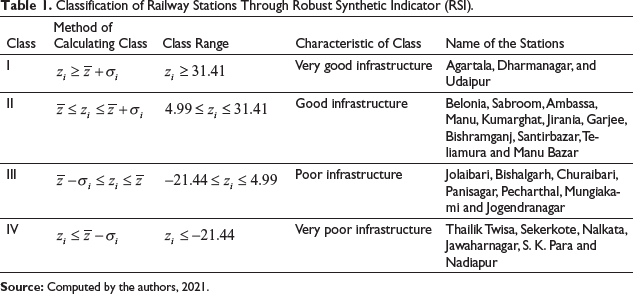
A Robust Synthetic Indicator (RSI) value for each station has been calculated by adding the corresponding normalised value of SI and ASI. RSI classification of railway stations over infrastructural facilities is reported in Table 4. Agartala (87.85), Dharmanagar (38.86), and Udaipur (34.44) railway stations are found with very good infrastructural facilities. There are 11 (40.74%) railway stations, namely Belonia (29.59), Sabroom (27.45), Ambassa (20.30), Manu (16.80), Kumarghat (16.35), Jirania (14.65), Garjee (10.32), Bishramganj (9.44), Santirbazar (9.32), Teliamura (9.12) and Manu Bazar (7.45) railway stations are observed with good infrastructure.
Poor infrastructure has been found in 7 (25.93%) railway stations: Jolaibari (2.54), Bishalgarh (2.01), Churaibari (–0.50), Panisagar (–3.46), Pecharthal (–4.16), Mungiakami (–11.79) and Jogendranagar (–11.93). The remaining 6 (22.22%) railway stations, that is, Thailik Twisa (–23.57), Sekerkote (–26.52), Nalkata (–27.98), Jawaharnagar (–29.39), S. K. Para (–30.12) and Nadiapur (–32.47) are reported with very poor infrastructure.
The physical environment imposes major constraints on transportation systems regarding what mode can be used, the extent of the service, its costs, capacity, and reliability (Rodrigue and Slack 2017).
Geology
The geological features are significant regulators of the route plan of railway transportation. The route choice helps to predict the antagonistic paraphernalia of geological structures. The state of Tripura exhibits a wide array of sedimentary rock characteristics of marine-mixed-fluvial type origin, ranging age from the uppermost Oligocene (38 million years from present time) to the recent period (Dey, Paul and Sarkar 2014). According to the Geological Survey of India, these sediments stratigraphy of state geology is divided into three groups. Dupitila formed during the Quaternary period, Tipam which is bent between Pliocene during Pleistocene period and Surma group have been laid down during Uppermost Oligocene (which lasted for 65 million years). The geological structure of the state is governed by local tectonic movement with a wide range of environmental conditions (Dey and Sarkar 2012). Tectonically, the region now comprises of a series of sub-parallel arcuate, elongated, doubly plunging folds arranged in the north-south direction. Wide flat synclines separate these folds for anticlines.
It has been observed that about 59.26% (16) railway stations of Tripura have been established on Tipam formation and the remaining 40.74% of railway stations of the state developed over Dupitila formation (Table 2). In Tripura, about 37.34% of land has been identified with Surma stratigraphic group subdivided in different formations, that is, Bokabil Formation, Upper Bhuban Formation, Middle Bhuban Formation, and Lower Bhuban Formation, but this formation is not exposed in Tripura where no railway station has been observed (Table 2). Local unconformity, lithic characteristics (oldest rock), and the stratigraphic position of the Surma group are the main causality of the nix development of railway infrastructure.
Stratigraphy of Tripura and Railway Infrastructure.

Stratigraphy of Tripura and Railway Infrastructure.
About 19 structural discontinuities with minor lineament, synform and antiform were found in Tripura (Figure 4). All structural discontinuities have been associated with Surma formation, and along the structural discontinuities, a lineament landslide zone has been observed; as a result, no railway station developed in Surma formation (Figure 4). About 45.45% of railway stations of Dupitila formation are found with good railway infrastructure, whereas 24.27% and 9.09% of railway stations have been observed with poor and very poor railway infrastructure, respectively. Two railway stations with very good infrastructure, namely Dharmanagar and Udaipur, are located in Dupitila formation. In Tipam formation, 32.25% railway stations have been observed with very poor railway infrastructure (Table 2). The epicentre of maximum earthquake (53.57%) reported from 1950 to 2017 with average magnitudes of 4.78–5.19 ML is located in Tipam formation. Due to high earthquake vulnerability infrastructural quality of railway stations are very poor (37.50%) and poor (25.00%). Due to urbanisation and associated facilities, few railway stations of this geological formation, like Agartala, Ambassa, and Kumarghat have good railway infrastructure. Spearman’s rho, a non-parametric correlation, has been calibrated between the geological formation and railway infrastructure and found a positive correlation (r = 0.270), but the relationship is not significant as the p-value is more than.05 (Table 3).

Correlations Between Railway Infrastructure and Geological Formation.

Relation Between Railway Infrastructure and Geomorphic Features.

Geomorphologically the state of Tripura, is characterised with the typical ‘ridge and valley’ topography of the late tertiary fold mountain belt, commonly known as Indo-Burman ranges (Purbanchal range).The elevation varies between 939 m in the north-eastern part to 15 m in the western part above the mean sea level (Saha 2014). The state’s physiography is marked by North–South linear anticlinal hill ranges and associated valleys. Locally ‘Mura’ represents hillocks which are the common word for many small hill ranges and peaks (Dhar 2021). Five prominent roughly north–south trending anticlinal strike ridges traverse the state from east to west; these are Jampui (939 m), Sakhantlang (782 m), Longtarai (482 m), Athramura (481 m) and Baramura (269 m). The height of the hills and steepness of the valleys increases by intensity from west to east direction. The plain areas is mainly covered in the western part of Tripura. Streams eroded the hill ranges and rivers, flowing through the valleys in between, and the eroded materials are used to spread over the western part of the state. Like any other piedmont plain, it is the product of both degradational and aggregational processes. This western portion of the state comes under the lower flood plain areas of the Ganga–Brahmaputra–Meghna (GBM) river system which is also fed by Khowai (166 km), Haora (53 km), Juri, Manu (167 km), Dhalai (117 km), Deo (98 km), Longai (98 km), Muhuri (64 km), Feni (108 km) and Gomati (133 km) rivers of Tripura (Tripura State Pollution Control Board, 2002). Those major rivers intersect the railway tracks about nine times in Tripura (Figure 4).
It has been observed that five predominant geomorphic features are found in Tripura, the alluvial plain, highly dissected hills and valleys, moderate dissected hills and valleys, low dissected hills and valleys and pediments pedeplain complex (Figure 4). It has been observed that 37.04% (10) railway stations are located in the alluvial plains where infrastructural conditions of maximum railway stations (50%) are good (Table 4). About 20% of railway stations in this geomorphic landscape have very good railway infrastructure. Only three railway stations have been found with poor infrastructure, namely Panisagar, Pencharthal and Bishalgarh. The Panisagar railway station is located on the alluvial plain of river Juri, Pencharthal and Bishalgarh are situated on the alluvial plain of rivers Deo and Bijoy, respectively. No railway stations have been observed with very poor infrastructure in this category. Maximum railway stations (51.85%) are found in the highly dissected hills and valleys.
It has been observed that there is a significant positive correlation between railway infrastructure and geomorphic features (Table 5). Ordinal Logistic Regression (OLR) model fitting information contains the –2 log likelihood for an intercept only (null) and the full model (containing the full set of predictors).
Correlations Between Railway Infrastructure and Geomorphic Features.

Correlations Between Railway Infrastructure and Geomorphic Features.
The likelihood chi-square test between railway infrastructure and geomorphic features found significant (χ2 = 5.098, the corresponding p-value is.078) improvement in the fit of the final model over the null model at 5% level (Table 6).
Ordinal Logistic Regression Model Between Railway Infrastructure and Geomorphic Features.

Features such as mountains and valleys have strongly influenced the structure of transportation networks, the cost, and the feasibility of transportation projects. Land transport infrastructures are usually built where there are the least physical impediments, such as on plains, along valleys, through mountain passes, or when necessary, through digging of tunnels.
The infrastructural development of the unevenly distributed railway stations are used to been measured (Table 7). The causality of unequal infrastructural distribution varies for multifaced reasons. Tripura has unique ‘Valley and Ridge’ (Tilla and Lunga Topography) topography (Sen et al. 2015). Due to physiographic hindrance, surface transportation has developed slowly (Mitra and Roy 2020).
Relation Between Elevation and Railway Infrastructure.

Relation Between Elevation and Railway Infrastructure.
It has been found that the maximum (17 out of 27, 62.97%) railway stations are located between 26 m to 50 m altitude (Table 7). The state’s track profile varies from 12 m to 360 m and is presented in its topography in Figure 2. Due to the closeness of the Gomati and Bijoy rivers, Udaipur and Bishalgarh railway stations are located 19 m above the MSL. However, Jawaharnagar and Mungiakami railway stations are located at 101.45 m and 110.18 m above mean sea level (MSL), respectively, for Atharamura and Longtharai hill ranges respectively (Figure 5). It has been found that physiographic structure influences the infrastructural development of the stations. Only 2 (7.41%) railway stations with very good infrastructure (Table 7) are located below 25 m height above MSL, namely Agartala and Udaipur (Table 7). Agartala railway station is located in between 23°45ˈto 23°55ˈ N latitudes and 91°15ˈ to 91°20ˈ E longitudes in the flood plain of the river Haora with 526292 total population (AMC 2018). On the other hand, Udaipur is the third largest railway station of Tripura, located on left bank of river Gomati with 37,781 population (Census of India 2011). Udaipur has significant value for religious tourism, archaeological tourism and heritage tourism. Bishalgarh railway station is also located at 19 m altitude due to the juxtaposition of the river Bijoy (Figure 5). Agartala city is located about 21.2 km away from Bishalgarh. For odd departure and arrival times of few trains (6) local people are used to travel by road, which is the primary causality of poor railway infrastructure.

8 out of 17 (47.05%) railway stations between 26 m to 50 m have the good infrastructure (Table 5). Those stations are Sabroom (31.00 m), Manu Bazar (35.00 m), Garjee (35.39 m), Bishramganj (35.91 m), Belonia (40.00 m), Kumarghat (43.05 m), Santirbazar (46.00 m) and Teliamura (46.54 m). Sabroom [23°00’05" N. and 91°43’11" E.] is located at southernmost point of the state of Tripura. Physiographically Sabroom railway station is located on the right bank of river Feni. Due to its geostrategic location with Bangladesh and sociopolitical demeanour Sabroom is identified as Geopolitical Hotspot. Concerning the geostrategic importance Sabroom, the railway station holds good infrastructure (Table 7). Manu Bazar railway station is located on the right bank of river Kalapania (Figure 6). Belonia railway station is located on the left bank of river Muhuri which is about 3.90 km away from the Indo-Bangla international border (Figure 6). Kumarghat railway station has a good railway infrastructure located at 1.37 km northeast of Kumarghat town, where about 13,054 people reside (Census of India 2011). This freight station serves Kumarghat town and the entire Unakoti district, where the total population is about 298,574.

Teliamura railway station is located on the left bank of river Khowai with an elevation of 46 m above MSL. This station has a good station infrastructure. Two railway stations, namely Sekerkote and Nadiapur of this group, have very poor station infrastructure. Those two railway stations act as halt stations or sub-stations of Agartala and Dharmanagar. Due to the close proximity of the National Highway (NH-8) and the peri-urban atmosphere Sekerkote has a huge potentiality to develop in future (Figure 6). A total of 4 (14.81%) railway stations fall under the elevation zone 51 m to 75 m. Among these, 2 (50%) railways stations, that is, Nalkata and S. K. Para has very poor station infrastructure. Both the stations are located 65 m above MSL. Pecharthal railway station is located 51 m above the MSL. The Juri River flows at 930 m south-east of the Pecharthal railway station. Only Manu railway station in this zone has good station infrastructure. Manu station is located about 59.95 m. above MSL. River Manu passes at 856 m south of the station (Figure 6).
Only 3 (11.11%) railway stations in Tripura are located at about 75 m height. Jawaharnagar and Mungiakami, these 2 (66.67%) railways stations having very poor infrastructure, are located at the hill range of Atharamura and Longtharai, respectively. Mungiakami railway station is located 110.18 m above the MSL, which is the highest railway station in the state. Due to physiographic hindrance, passenger mobility is very few in Jawaharnagar (less than 300 per month), resulting in poor station infrastructure. Ambassa (79.29 m) is one of the high-altitude railway stations of Tripura, located on the right bank of river Dhalai (Figure 6). However, due to functional activities like a district (administrative) headquarter, 11th largest populated town in the state and the location of the Border Security Force (BSF), camp Ambassa has good station infrastructure. The maximum stations with very good infrastructure have been found located at the low altitude. With the increase in height, the standard of station infrastructure decreases significantly.
It has been observed that there is a negative relationship between railway infrastructure and the elevation of the stations (Table 8). The result of the correlation between railway infrastructure and elevation indicates if elevation increases, railway infrastructure decreases. But p-value of the relationship is.321, which depicts that the relationship is not significant statistically. There are multiple issues in the relationship between railway infrastructure and elevation.
Correlations Between Railway Infrastructure and Elevation.

Triangulated Irregular Network (TIN) represents the state’s surface morphology (Figure 7). As we know, Tripura is the land of Tilla and Lunga. Polymeric surfaces like Tilla and Lunga are controlling station infrastructure. It has been found that maximum railway stations are located in the valley region. Agartala, Dharmanagar, Udaipur railway stations with very good infrastructure are located in the valley of rivers Haora, Juri and Gomati, respectively (Figure 3). The stations with good infrastructure, namely Belonia, Sabroom, Ambassa, Manu, Kumarghat, Jirania, Garjee, Bishramganj, Santirbazar, Teliamura and Manu Bazar, are also located in the valley region.

Only 2 (7.41%) railway stations having very good infrastructure lying less than 94.4 m relative relief. The railway station with very good infrastructure becomes poorer with the increase of relative relief, 10 (37.04%) railway stations are found at 94.40 m to 188.80 m relief zone (Table 9); 2 out of 3 (66.67%) railway stations above 283.20 m relative height are observed with poor infrastructure. It is explicit that with the increase in relative height, the infrastructural facilities of the station diminish significantly (Table 9).
Relation Between Relative Relief and Station Infrastructure.
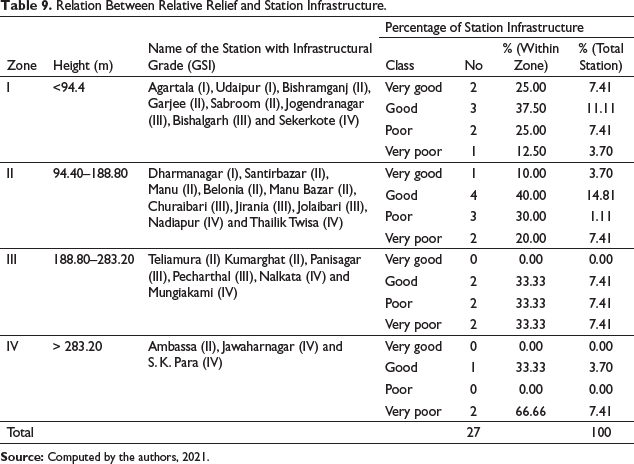
Relief of the stations and the surrounding area has been reflected through relative relief. It helps to understand the hinterland of the station. The hinterland of 7 (25.93%) railway stations is located below 94.40 m. (Figure 4). Relative relief of 11 (40.72%) railway stations and surrounding area fall under 94.40 to 188.80 m. 6 (22.22%) railway stations’ relative relief are above 188.800 m. Relative relief of only 1 (3.70%) railway station is more than 283.20 m (Figure 8).

It has been observed that there is a significant negative correlation between railway infrastructure and relative relief (Table 10). Increasing relative relief has a significant negative influence on railway infrastructural development.
Correlations Between Railway Infrastructure and Relative Relief.

Average slope plays a crucial role in the infrastructural development of railway transport systems (Orme 2013). About 27.48% area of Tripura has a gentle slope (<15°) where 48.15% of railway stations are located (Figure 9). Among them, 15.38% of stations have very good infrastructure, 46.15% of stations have been identified with good infrastructure (Table 11).

Relation Between Slope and Station Infrastructure
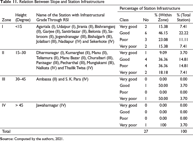
About 23.08% and 15.38% of railway stations are characterised as poor and very poor railway infrastructure, respectively. It has been found that about 35.56% land of Tripura is situated between 15 degrees to 30 degrees slope, where 40.74% of railway stations are established. Among them, 9.09% of railway stations have very good infrastructure, namely Dharmanagar. 36.36% of railway stations (4) have good infrastructure, and the same percentage of railway stations are found with poor infrastructure (Table 11). Only 18.18% of railway stations are located between 15 degrees to 30 degrees slope with very poor railway infrastructure. Moderately steep slope (30 degrees to 45 degrees) is found in 22.97% area of the state where only two railway stations are located. Among those two railway stations, one station (50%) has good infrastructure and another (50%) has very poor railway infrastructure; 100% of railway stations of Tripura located above 45-degree slope have very poor railway infrastructure (Table 11).
It has been found that slope and railway infrastructure have a strong negative relationship which epitomises that with the increase of slope the railway infrastructure (r = –0.947 and corresponding p-value.0146) declines. The relationship between slope and railway infrastructure is significant at 5% level.
It has been found that slope and railway infrastructure have a strong negative relationship which epitomises with the increase of slope, the railway infrastructure declines (r = –0.947 and corresponding p-value.0146 %). The relationship between slope and railway infrastructure is significant at 5% level (Table 12).
Correlations Between Railway Infrastructure and Average Slope.

The curvature in the railway network limits the capacity of railway infrastructure (Kampczyk 2020; Gašparík and Cempírek 2019). The railway station’s design and surrounding area’s design and geometry require certain measures to increase the track, line capacity, and train mobility (Burno and Raffaele 2018; Al-Douri et al. 2016). It has been found that about 13.18% of the state’s land has very low curvature, where about 33.33% of railway stations are located, namely Agartala, Jirania, Bishramganj, Garjee Santirbazar, Jogendranagar, Bishalgarh, Jolaibari and Sekerkote (Table 13). Among them, about 44.44% railway stations are observed with good infrastructure. About 25.93% area of the state was observed with low curvature, where 7 (25.93%) railway stations are located. Out of 7, 3 (42.86%) railway stations in this zone have good infrastructure (Figure 9); 5 (18.52%) railway stations in Tripura are located in the moderate curvature zone. About 40% of the railway stations located at moderate slopes have very poor infrastructure, namely Nalkata and S. K. Para railway stations (Table 13); 6 (22.22%) railway stations are located in high and very high curved areas of Tripura.
Relation Between Curvature and Station Infrastructure.

Relation Between Curvature and Station Infrastructure.
In the high and very high zone, the infrastructure of the maximum railway station is poor (33.33%) and very poor (33.33%), respectively. It has been found that there is a negative correlation between curvature and the infrastructure of the railway station (r = –0.5969).
Curvature confines the performance of railway infrastructure (Figure 10). Due to curvature, a more tractive force is required to pull a train around a curve. It increases wear on both the wheels and the rail because of flanged wheels. At too high a speed, a tight curve can cause derailment or cause the train to tip over—no such kind of incident, however, was reported in Tripura.

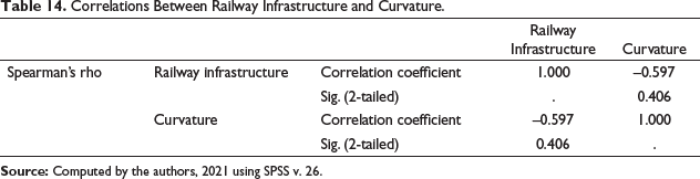
It has been found that there is a negative relation (r = –0.0597) between railway infrastructure and curvature (Table 14). The result depicts that curvature negatively influences the railway infrastructure.
Correlations Between Railway Infrastructure and Curvature.
Forest cover also plays a significant role in station infrastructure (Iribar et al. 2020; Jaswal et al. 2020). In Tripura, Nalkata, S. K. Para, Jawaharnagar and Thailik Twisa are located in the forested area of Longtharai, Atharamura, Baramura and Deotamura hill ranges and the infrastructural facilities of those stations are considerably very poor (Figure 11). The Normalised Difference Vegetation Index (NDVI) is generally used for green density in an area. Here, it has been considered to find out the relationship between railway infrastructure and forest cover.

It has been observed that there is a strong negative (r = –0.074) relationship between railway infrastructure and forest cover (Table 15). The correlation matrix expresses that railway infrastructure is poor in a forest area.
Correlations Between Railway Infrastructure and Forest Cover.

Urbanisation also influences the infrastructural development of railway stations (Kasraian et al. 2019). Normalised Difference Built-up Index (NDBI) is considered to measure the level of urbanisation around the railway stations of Tripura, and it has been found that there is a positive relation between railway infrastructure and urbanisation (Table 16).
Correlations Between Railway Infrastructure and Urbanisation.

Correlations Between Railway Infrastructure and Urbanisation.
Railway stations located in an urban environment have more accessibility and developmental impacts, contributing to Transit-Oriented Development (TOD) and the overall development of railway infrastructure (Debrezion et al. 2007; Kasraian et al. 2016; Shi 2016; Zacharias et al. 2016). In Tripura, it has been found that the stations located in urbanised areas like Agartala and Dharmanagar have very good infrastructure. Udaipur, Belonia, Sabroom, Kumarghat, Manu, Teliamura, Jirania, located in the peri-urban area, are found with very good infrastructural facilities. Build-up Index (BI) illustrates that the stations which have more build-up (majorly settlement) area, railway infrastructural facilities of those stations are better due to its hinterland and passenger mobility (Besinovic 2019; Duranton and Puga 2013; Ricci et al. 2017). Similar results were found in Tripura, except in Bishalgarh and Panisagar railway stations (Figure 10). The reason for the anomaly is inherent in the odd frequency of train services.
It has been found that railway infrastructure has a positive relationship with monthly passenger mobility, but a negative relationship is found with the growing distance between the station and the town’s population size (Table 17). The result depicts that the increasing distance of nearby towns from railway stations negatively impacts station infrastructure. But the population of the nearby town and monthly passenger mobility from the concerned station have a significant positive correlation (Table 17). Again, a positive correlation is found between monthly passenger mobility and station infrastructure. So, according to predictive transitivity, the relationship between station infrastructure and the population of the town should have a positive relationship.
Correlations Between Station Infrastructure, Distance from the Nearest Town, Population of the Town and Monthly Passenger Mobility from the Nearest Neighbour Railway Station.

According to the Census of India, 2011 there are 20 municipal towns in Tripura with different population sizes (Census of India 2011). Urban structure, distribution and population size of town significantly influence the railway infrastructure (Li et al. 2012). The distribution of urban centres has been measured through Nearest Neighbour Index (NNI) (Clark and Evan 1954). It has been found that towns are randomly distributed (Rn = 1.24) with a corresponding observed mean distance of 15.33 km and an expected mean distance of 12.35 km. It has been found Jirania town (0.978 km) is closest to the Jirania railway station, and Khowai town is located far away from its nearest railway station.
Bishalgarh (1.113 km), Panisagar (1.137 km), Kumarghat (1.286 km), Dharmanagar (1.291 km), Ambassa (1.675 km), Sabroom (2.681 km), Belonia (2.769 km) and Teliamura (2.868 km) towns are located within three km from respective railway stations (Figure 12). About 15% of the towns of Tripura are located within 3 to 6 km radius of the railway stations. There are 40% (8) towns in Tripura which are located beyond 6 km from the railway stations, namely Ranirbazar (6.607 km), Melaghar (12.241 km), Sonamura (16.172 km), Kailashahar (16.406 km), Mohanpur (16.533 km), Amarpur (17.891 km), Kamalpur (20.020 km) and Khowai (22.803). It has been found that there is a negative relationship (r = –0.027) between railway station infrastructure and the distance of the nearest town from the station (Table 17).

The expected passengers of a railway station are mainly the people of nearby towns and others, and the infrastructural facilities of the railway station plays a crucial role in the travel choice decision system (Hasiak 2019; Polom 2018; Tian et al. 2020). Agartala is the prime city of the state, and the population size of Agartala is much larger than any other town of the state (Debbarma et al. 2018). After applying Zipf’s Rank Rule on the urban population of Tripura, it has been observed that Agartala is the rank one populated town of the state, followed by Dharmanagar (rank-2) and Udaipur (rank-3). All three most populated towns of Tripura have very good railway infrastructure because the population of the nearest urban unit help to increase passenger mobility. Average monthly passenger mobility has a significant positive correlation (r = 0.768) with station infrastructure at a 1% level (Table 18).
Correlations Between Station Infrastructure and Average Monthly Passenger Mobility.

The coefficient of determination (R2 = 0.590) elucidates the variation of station infrastructure on average monthly passenger mobility (Table 19). In the model, Adjusted R Square is 0.573 mean station infrastructure contributes 57% of the variation in passenger mobility (Table 19).
Regression Model of Station Infrastructure and Average Monthly Passenger Mobility.
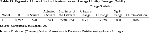
An F change is a test based on F test used to determine the significance of R Square change. It has been observed that the R Square change is statistically significant at a 1% level (p-value is less than.05). It means that station infrastructure significantly influences passenger mobility (Table 19).
The central argument of the article is, does Physio-environmental determinism influence the Infrastructural development of railway stations? Many researchers work on the idea of Physio-environmental determinism which holds that the physiographic environment, particularly relief, slope, curvature, and forest cover, dictates the trends in infrastructural development. Butuner et al. (2020), shows the potential of railway transport system as an urbanistic and landscape feature has led to the creation of infrastructural development. In addition to being crucial to the foundation and expansion of the urban fabric, railway transportation have had an impact on both the rural and urban terrain. Stoilova (2019), has defined level of physiographic impact on infrastructural development of railway transport. Adverse topography is the barrier of railway construction (Dorse et al. 2017). Our study has observed that railway infrastructure significantly varies from station to station due to differential spatial organisations. Similar kind of result has been found in the work of Palin et al. (2021), Besinovic (2020), Gašparík and Cempírek (2019), Funk et al. (2019), Gasparik et al. (2018), Kasraian et al (2016), Roy and Mitra (2016), Lindfeldt (2015), Debrezion et al. (2007). After critical discussion on the findings it can be asserted that comparatively less complex physio-environmental location has relatively better railway infrastructure. The homeomorphism of the literatures suggest physiography influence infrastructural development which supports the philosophy of environmental determinism. In phenomenological point of view environmental determinism based development pattern creates the regional disparity. The possibilistic approach addresses infrastructural development of railway stations in different physio-environmental conditions with more phenomenological way.
Conclusion
The Railway Infrastructure of Tripura is significantly varied among different railway stations due to spatial variation. A Robust Synthetic Indicator (RSI) has been introduced to classify the infrastructural development of railway stations in Tripura. Agartala, Dharmanagar and Udaipur have very good station infrastructure due to locational advantages as those stations play a crucial role in passenger mobility. Suburban or Periurban railway stations like Jogendranagar, Sekerkote, Teliamura, Jirania, Manu, Panisagar, have huge potentiality for future development. Thailik Twisa, Nalkata, Jawaharnagar, S. K. Para, and Nadiapur railway stations need more infrastructural facilities to attract more passengers. Jirania is the most efficient rail freight station in Tripura. The spatial attributes of Jirania are the main reasons of its efficiency. The causal interference of differential physiographic factors like surface topography, relief structure, slope, curvature, forest cover and a few developmental factors like distance from the nearest urban centre and passenger mobility are essential for improving infrastructural conditions of the railway stations. Passenger mobility is the most influential factor for the development of station infrastructure. The concluding observation is that different physical attributes play an important role in the infrastructural development of the railway stations of Tripura. The causal interference has been explained in the light of traditional debates on physio-environmental determinism and positivism. The possibilistic approach addresses infrastructure-driven materialism. Here railway infrastructural parameters are considered materialistic elements and found this materialistic development mostly influences passengers’ mobility. Passengers’ mobility is a cognitive choice of positivism. Therefore, it can be concluded that infrastructure-driven materialism is more influenced by positivism than physio-environmental determinism.
Footnotes
Declaration of Conflicting Interests
The authors declare no potential conflicts of interest with respect to the research, authorship and/or publication of this article.
Funding
The authors received no financial support for the research, authorship and/or publication of this article.
