




Abstract
This study explores how rapid industrialization alongside a lack of regulatory controls through policy and planning encourages unplanned rapid urbanization in suburban areas. Taking Konabari–Kashimpur, a rapidly growing suburban area of the Greater Dhaka Region (GDR) as a case study, data has been collected through 16 key informant interviews and a questionnaire survey of 359 households in the area. The study finds that the readymade garment industry plays a significant role in the growth of this area. Negative externalities in the core area, the availability of large land parcels at a cheaper price, abundant labour supply and good transport connectivity to the core city make it favourable for industrialization. It is further found that industrialization and the forms of development taking place have largely occurred in an unplanned manner. Low-skilled and labour-intensive industry-driven growth has produced mixed-use intense development dominated by industrial and low-class residential uses. The impact of such growth on the suburban natural environment, infrastructure and society is found to be significant. The natural environment has been destroyed to provide land for industry and housing for workers. Basic service infrastructure and urban amenities have not increased proportionately to the growth of activities and the population. Moreover, the absence of a planning authority and land use regulations has worsened the situation further. It is concluded that the provision of basic infrastructure through planned intervention is required for sustainable urbanization.
Introduction
There is a common conception that urban transition in developing countries follows a similar process and pattern to that developed countries experienced a century earlier (Fox, 2011; World Bank, 2009). However, this argument can be challenged as the growth of cities in developed and developing countries is motivated by different drivers, and the context in which this growth occurs is also different (Farrell, 2017). The nature and process of urban growth in developing countries, especially the growth of large cities, is characterized by (a) rapid urbanization due to the rural-urban migration of people for economic reasons (Lall & Selod, 2006; Mazumdar, 1987), (b) large city favouritism which may lead to the excessive concentration of economic activities and population (Choe & Roberts, 2011; Henderson, 2002), (c) the exploitation of natural environments (Seto et al., 2012; Wu, 2014) and cheap labour for economic gains (Checkland, 1981; Myint et al., 2015), (d) and increasing gaps between the demand and supply of resources and infrastructure (i.e., land) (Henderson, 2000). Moreover, the lack of regulatory controls and poor governance mechanisms commonly found in cities within developing countries often significantly impacts the urban growth process (Huang & Tang, 2012).
The consequences of such a process of urbanization can be seen not only in core urban areas but are also prominently visible in their suburban or periphery areas (Cohen, 2006). In most cases, further urban growth localizes in the nearest small-town centres or suburban areas that have better connectivity to the core (Dawkins, 2003; North, 1955). Such a pattern can be seen in many metropolitan cities in developing countries. Moreover, since manufacturing industrialization is one of the key forces driving urbanization in developing countries (Choe & Roberts, 2011), new manufacturing firms and their support industries tend to locate themselves in geographically advantageous areas where access to large land parcels is cheap and the negative externalities of excessive concentration do not exist, as well as where regulatory controls that exist in the core areas can be avoided (Helsley & Strange, 1995).
Dhaka, the capital city of Bangladesh, is one of the fastest growing and dense urban agglomerations in Asia and contains population of over 15 million. It is the most competitive economic hub of the country and has been experiencing rapid urbanization and industrialization (Choe & Roberts, 2011; Islam & Hossain, 2013). The pattern and process of growth in the city region is similar to that of cities in other developing country, as described above. Many of the contemporary studies on Dhaka have considered: the availability of developable land, land elevation, transport networks as the determinants of urban expansion (Dewan et al., 2012); manufacturing agglomerations and specialization as the engine of economic growth (Choe & Roberts, 2011); the lack of proper planning along with weaknesses in governance as the determinants of unplanned and uncontrolled growth. While the localization of growth in suburban areas has been predicted, in most cases these areas are not prepared to support healthy and sustainable growth. Despite having developable land and connectivity to the core city, in many cases, inadequate infrastructure, minimum or no regulatory controls, a lack of land use planning and weaknesses in urban governance encourage the exploitation of the suburban environment and resources through growth.
Although a considerable body of research has focused on the spatial growth pattern in Dhaka, less attention has been paid to the severity of the consequences of industrialization induced unplanned growth in its suburban areas, particularly in social and environmental domains. Considering the gap, this article addresses two key issues of urbanization: (a) industrialization influencing spatial expansion and suburbanization and (b) planning and governance weaknesses and the impact of these factors shaping suburban ecology and society. We have taken Konabari–Kashimpur, a rapidly growing suburban area of the Dhaka metropolitan region as the case for this study. This area has been experiencing rapid manufacturing industrialization and population growth through migration over the last two decades. The focus of this article is to address the question, ‘How does rapid industrialization, along with a lack of regulatory controls (policies and plans), encourage unplanned rapid urbanization in the suburban area and to what extent does this lead to the emergence of an unwanted growth centre from social and environmental perspectives?’
The article starts by presenting a brief review of the urban growth literature focusing on the nature of urban and suburban growth in developing countries and the trickle-down effects of industrialization induced growth. Then, the contextual reasoning for selecting Konabari–Kashimpur as a case study is presented, followed by a brief discussion on data collection and analytical procedures. Finally, the findings of the study have been presented according to the study objectives, and a conclusion is drawn, which addresses the role of industrialization induced growth and regulatory weakness on suburban growth dynamics.
Suburban Growth and Industrialization
Factors and Processes of Suburban Growth in Regional Growth Theories
Urban growth is a complex systemic process shaped by an infinite range of factors (Storper, 2017). Some factors are geographically created (Dawkins, 2003; Despotović & Cvetanović, 2017), some are exogenously shaped (Barro & Sala-i-Martin, 2004; Dawkins, 2003) and some emerge endogenously (Capello & Nijkamp, 2011; Huggins, 2016; Jones et al., 2016; Krugman, 1991; Storper, 2017). Institutional structure, associated human behaviour and firm level strategy play a crucial role in generating growth through the efficient use of resources within a region or city (Huggins & Thompson, 2021; North, 2005; Rodrik, 2000).
During the first stage, regions grow by utilizing their comparative advantages (Hirschman, 1958; Myrdal, 1957) and space acts as a force for interaction and network creation (Huggins & Thompson, 2021; Perroux, 1950). In growth-pole (or core-periphery) theories, these forces are considered as the centripetal forces of core development (Krugman, 1991) that attract firms, labour and capital from peripheral regions. This process of accumulation in a particular region is seen as the wave of polarization in the growth-pole theory (Perroux, 1950) and the backwash effect in the cumulative causation theory (Myrdal, 1957). Over time, an increasing number of firms and people in the city create demand for more space to continue growth and to retain a competitive position. However, physical land resources are limited, and there is a threshold capacity to this land. In response to increasing demand, the city expands spatially to accommodate greater activities and economies and, finally, loses its initial spatial identity (North, 1955). This spreading of the city is termed a ‘wave of dispersion’ in Perroux’s growth-pole theory (1950), ‘spread effects’ in Myrdal’s growth theory (1957) and ‘trickle-down effects’ in Hirschman’s theory of linkage (1958). The surrounding areas of a big city or large agglomerations become a preferable location to accommodate further growth (Dawkins, 2003; Vernon, 1992) due to its proximity to the core, lower land rent, market size, greater available land for development, labour availability and comparatively low-concentration-induced negative externalities than the core city area. Krugman (1991) classifies these factors into two different directional forces: (a) centripetal forces (influenced by market size, developed labour pool, positive externalities, etc.) and (b) centrifugal force (immobile production factors, land rent, negative externalities, etc.).
Industrialization and Its Effects on Urban and Suburban Growth Processes in the Cities of Developing Countries
Industrialization, especially growth within the manufacturing industry, contributes to aggregated urban and economic growth (Szirmai, 2012) and is believed to offer opportunities for capital accumulation (Szirmai & Verspagen, 2015) as well as economies of scale (Kaldor, 1966). In many developing countries, manufacturing industries generate a significant number of jobs which play a crucial role in reducing unemployment (Nazem et al., 2014). Moreover, manufacturing sectors have significant linkages and spill over effects (Guerrieri & Meliciani, 2005; Szirmai & Verspagen, 2015). Thus, it appears that industrialization, particularly in manufacturing sectors, leads to the rapid growth of the city economy and its population. When a city reaches a saturated stage of densification, it starts to expand spatially towards suburban or fringe areas (Smith & Scarpaci, 2000). This process includes suburban areas in the dynamic urban domain and transforms them into a new economic hub dominated by industrial activities. Many large urban agglomerations in developing countries have been experiencing such urban growth and suburban transformation in recent time (Choe & Roberts, 2011).
There is a growing concern over industrialization induced urban development in developing countries (Henderson, 2002). However, its negative consequences are sometimes ignored in city strategies, while economic prosperity takes priority. Most of the key industries in developing countries are export-oriented and create low-value-added jobs with low wages (Checkland, 1981; Myint et al., 2015) in order to compete in the global market. Moreover, most of these jobs are temporary and lack social security (Jomo, 2016; Warr, 1989). Therefore, despite creating jobs, such growth contributes very little to improve conditions of poverty, the living standards of workers and the urban quality of life. The major concerns of the industrialization process are mostly related to environmental degradation and natural habitat loss (Seto et al., 2012; Wu, 2014). Risks of urban flooding and waterlogging increase due to the loss of agricultural land, natural drainage systems and wetlands (Dewan & Yamaguchi, 2008). Moreover, the urbanization process in suburban areas creates pressure on existing infrastructure and utility services. Housing is probably the sector where the impact of growth is most significant. Industry workers demand low-cost housing close to their workplace due to their low affordability (Sultana & Nazem, 2020). To meet such demand, poor-quality housing such as slums have been developing in suburban areas. These kinds of settlements are generally overcrowded and unhealthy (Islam et al., 2006).
The Role of Planning and Governance in Suburban Growth in Developing Countries
It has been argued that the interaction of behavioural, institutional and regulatory factors shape patterns and processes of growth (Huang & Tang, 2012; Huggins & Thompson, 2021; Jackson, 2016). According to bid-rent theory, users substitute some factors for achieving better utility from localizing in certain places. For instance, if industries are affected by regulations in the inner city, they will try to move outside to minimize the effects; if households are affected, they will relocate themselves to other areas. Helsley and Strange (1995) argue that restricting growth in one community through regulation will also negatively impact neighbouring communities where regulation is low by pushing growth onto these communities. Therefore, local government decisions with regards to land supply and land use may exacerbate the sprawl problem, because land developers and households can easily avoid growth control restrictions by moving out to another area (Glaeser & Kahn, 2004; Kearsley, 1983; Pacione, 2009). It has been found that planning efforts are not sufficient to manage urban growth and growth induced risks in developing countries. Therefore, quality of life and public service issues are exacerbated by the lack of planning and weak governance in developing countries.
Methodology
Selection of the Case Study Site
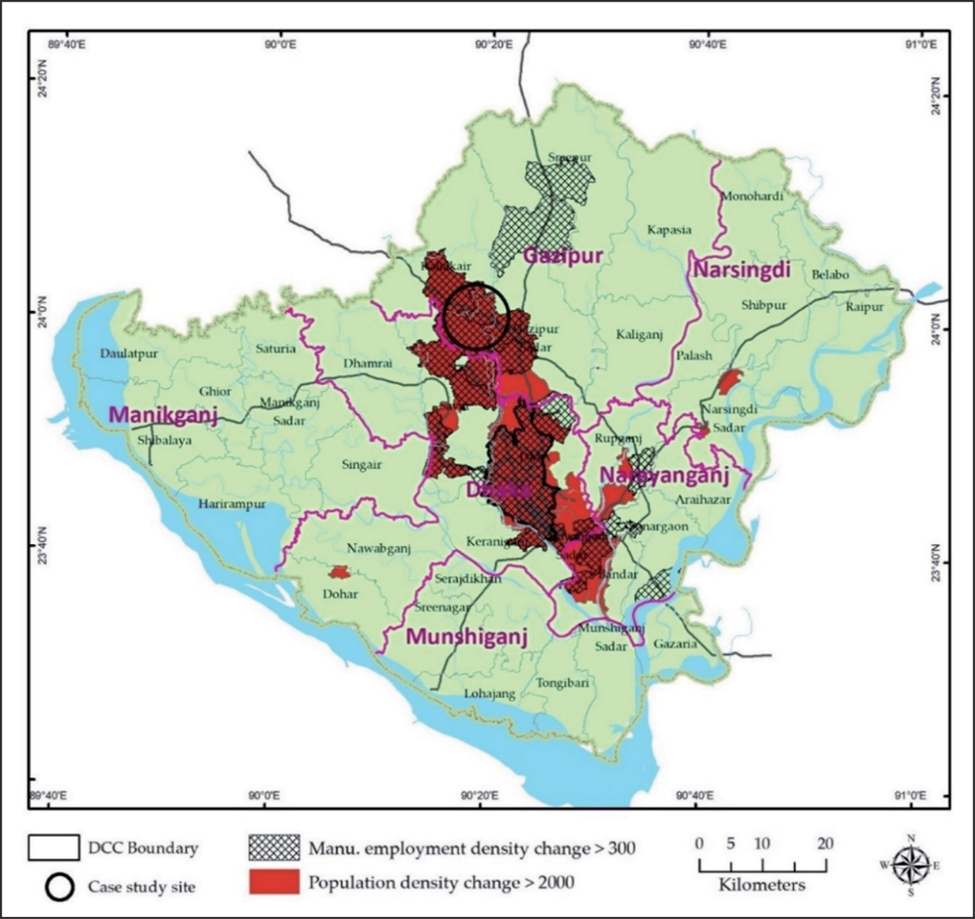
To select the case study site, we have first identified potential suburban areas (Savar-Ashulia area, Gazipur Sadar area, Shiddirganj, Konabari–Kashimpur area, etc.) in the Greater Dhaka Region (GDR) based on the following criteria: (a) a location in the rural-urban fringe region and (b) experiencing high rates of growth for population and industrial employment. We choose to study the Konabari–Kashimpur area because it is the only one which emerged as a suburban centre from a purely rural area and is the most recent one. Figure 1 shows the location of the case study site with other potential candidate sites within the GDR.
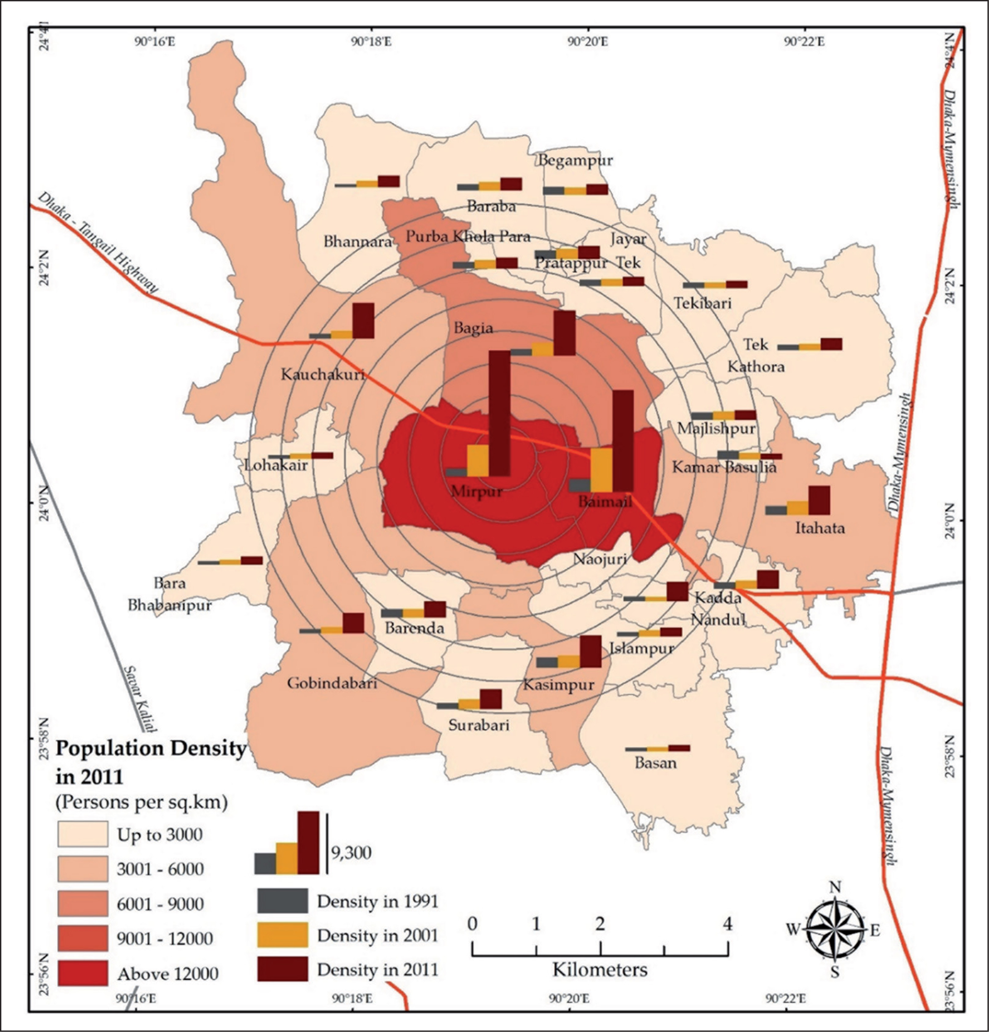
There were 83 thousand people living in the Konabari–Kashimpur area in 1991 (BBS, 1993), which increased to 143 thousand in 2001 (BBS, 2006) and 408 thousand in 2011 (BBS, 2012a) (Table 1). The annual population growth rate between 1991 and 2001 was 5.59%, increasing to 11.03% between 2001 and 2011. The growth rate was very high in the case site as compared to the average regional (GDR) growth (4.1% per year) (Nazem et al., 2014). The idea that rapid growth results in population density increases is proven through the fact that the population density per square kilometre increased from 921 in 1911 to 1,587 in 2001 and 4,518 in 2011.
Demographic Transition in the Study Area

Data Collection and Analysis
The study employed both qualitative and quantitative methods for data collection. First, qualitative data was collected through a structured interview survey and then a questionnaire survey was conducted to collect quantitative data to supplement and address the findings from the interview survey.
Structured Interview Survey
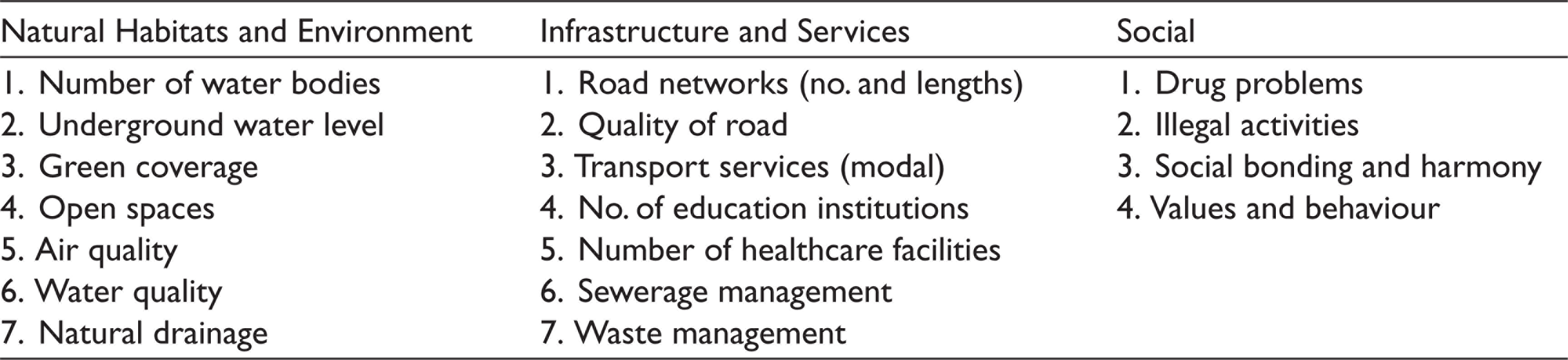
The interviews were conducted with key informants. Key informants were selected based on the fact that they had been living in the community for at least for 20 years. In total, 16 interviews were conducted at three different locations: Kashimpur (southern part), Konabari (central part) and Ambagh (northern part). The aim of the interviews was to explore the growth process in the area in order to assess the impact of such growth on the components of a liveable environment (socio-economic, environmental and infrastructural). The list of assessed components is presented in Table 2. A Likert scale (1 = worst to 5 = best) was used to score the current and past conditions of each component. Moreover, the role of planning in such a growth process has also been investigated.
The interview data have been analysed through the interpretive approach. The focus of the analysis is to provide a meaningful cause and effect relationship. As the impact assessment data was based on a Likert scale for two periods, the paired t-test analysis was undertaken to evaluate the significance of the changes of the components (significant at 0.05 level).
List of Components Assessed by the Interview Survey
Questionnaire Survey
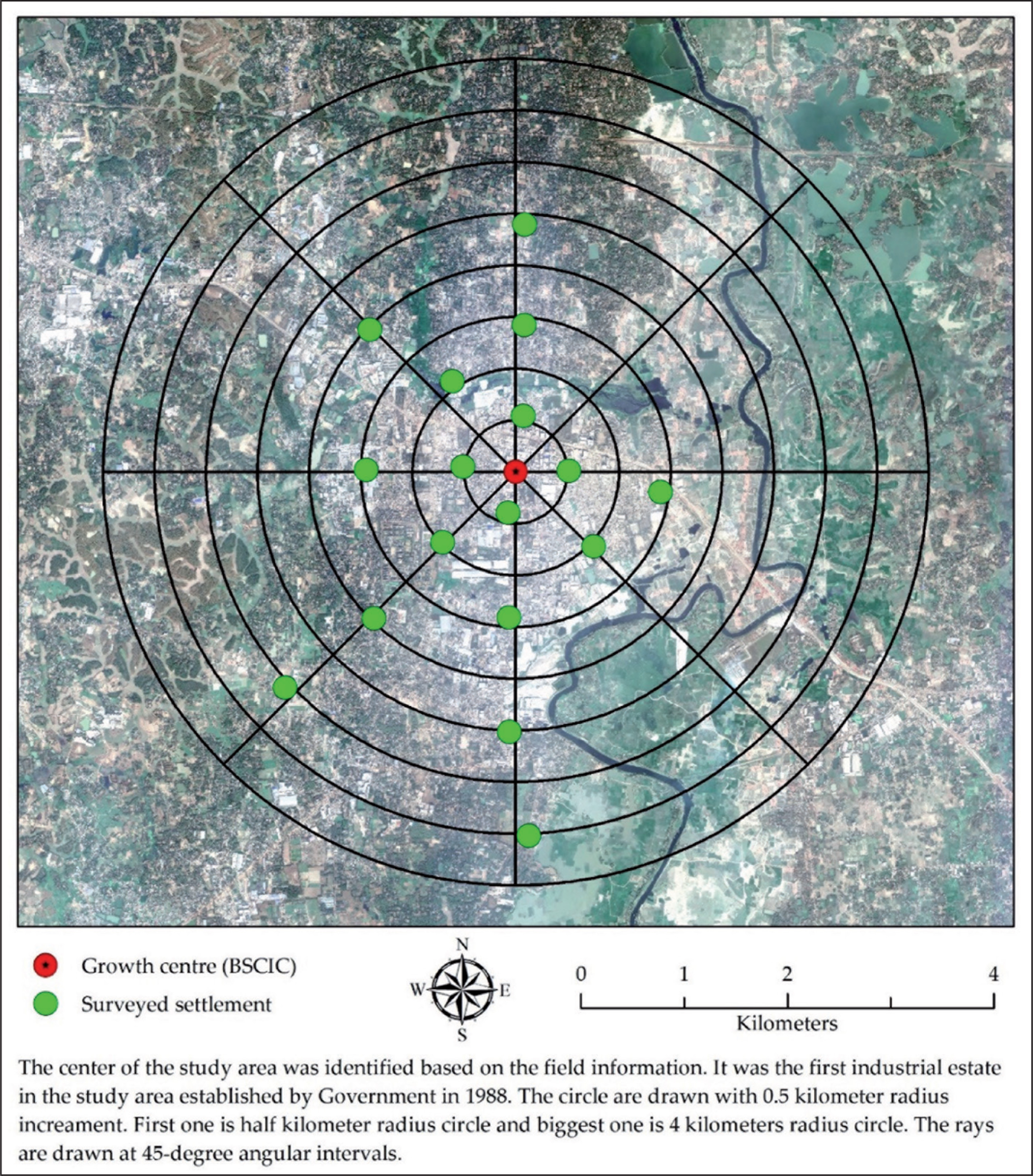
A questionnaire survey was conducted across 359 households to investigate the: (a) migration dynamics; (b) income and occupational patterns, in order to identify which sectors offer the most jobs to migrants; (c) the advantages and disadvantages of living in suburban areas as compared to the core city area. The study employed a cluster sampling framework to identify representative samples from migrant families. Some baseline information for the sampling came from the interview survey. To capture a high proportion of migrant households, the study focused on surveying households in semi-concrete dwelling units, which is where the migrants and the working class prefer to live. For this purpose, Google Earth’s historical images between 2004 and 2017 were assessed to identify the cluster (settlements) of semi-concrete dwelling units in the area. Filtering was then undertaken to identify the settlements that were constructed between 2004 and 2017, as it can be assumed that there is a high possibility of finding migrant households in the newly constructed settlements. In total, 17 settlements (or clusters) were surveyed. A higher representation from the dense area (especially around the growth centre) was ensured while selecting the sample settlements. Figure 2 shows the growth centre and the locations of the settlement clusters. We surveyed all the households of a settlement cluster when the number of households in the cluster was less than 30. For other large settlements, the first 20 households were surveyed starting from the settlement’s entrance and then in a clockwise direction. Finally, a total of 359 households were surveyed.
The questionnaire survey data was mainly analysed using descriptive statistics (frequency table, central tendency, standard deviations, etc.). The data classification followed the national or the census classification schemes to make them comparable to secondary statistics.
Findings and Discussions
Manufacturing Industrialization Induced Growth
Figure 3 shows the population growth and densification pattern in the study area. From the secondary data (both population and economic data), it can be assumed that population growth in the study area is industrialization induced. The interviewees confirm that large-scale manufacturing industries, especially the readymade garment (RMG) industry, played a key role in the growth of this area. Most of the interviewees discussed the government established BSCIC (Bangladesh Small and Cottage Industries Corporation) at Konabari in 1988, with this intervention considered to be the starting point for the evolution of the densely industrialized area. Both local people and people from outside of the area worked in the BSCIC. Due to a lack of good transport connectivity, many of the outsiders moved to the area, purchased land and settled in the locality permanently.
Although the area started to receive migrants from 1990 until around 2000, the flow of population was very low and only BSCIC-oriented people. However, after 2000, this growth accelerated when some large readymade garment factories also moved there. One interviewee argued that
The growth of this area was mainly due to only one industry sector, the readymade garment industry. You will find some other suburbs or peripheries are also growing due to this sector both in terms of population and size of the economy. This sector has huge labour demand. There are several factories here that have employed more than ten thousand workers. Thus, such a firm is responsible for bringing in at least five thousand families in this area.
The household survey data also confirms the contention of interviewees that the population concentration and growth in this area is migration induced, and that the area is again receiving a massive influx of migrants in recent times, mostly after 2000. The household survey indicates that about 97% of the surveyed families are migrants. About 98% of migrant families migrated to the area after 2000, and more than 72% came after 2010. Most of the migrant respondents (72%) had migrated from their place of origin to search for jobs, followed by marital migration (13%), migration with the family (7%) and due to disaster (3.5%).
The household survey results also show that more than three-quarters of the employed respondents are involved in the manufacturing sector. More than 70% of the employed respondents are directly involved in the garment sector, followed by 10.5% in small businesses. The survey also found that about two-thirds of the employed members of the surveyed families work in the garment sector and 58% of the surveyed family’s income comes from the garment sector. Moreover, 77.5% of the families have at least one earning member who is employed in the garment sector. Since informality is a common phenomenon in developing countries, the study also found that about 9.5% of the employed members of the surveyed families were engaged in small businesses which were mostly informal.
During the interviews, the key informants were asked, ‘Why has this area become favourable for industrial development although it was a typical rural area before 1990?’ The responses were similar from the interviewees and one interviewee made a clear comment on this, quoting that
I think that there were several factors responsible for industrialisation here. The availability of developable land with a cheaper cost, the good transport connectivity to the core area, an export processing zone (EPZ) about 25 kilometres west and another rapidly growing suburb ‘Savar’ in the south-west (nearly 20 kilometres) ensure the possibility of easily accessible labour. Moreover, a lot of seasonal workers in this area, who worked for about five months each year in the nearby brickfields, also became garment workers due to the permanent and comparatively high paid nature of the job. The nearby river ensures the availability of water for industrial use. Finally, and most importantly, this area is just beyond the boundary of the planning authority and thus the development faced fewer restrictions.
Another interviewee also commented that
The RMG is the most booming sector in Bangladesh. The factories need a large setup and huge labour. Therefore, they prefer a large parcel of land and a lot of cheap labour to enhance their profit. A good connection with the core city and other nearby clusters, and the availability of flood-free land parcels encouraged the investors to set new plants in this area.
The study found that not only were people from the rural peripheries migrating to the area, but also from the central city area. About 15% of the migrant respondents came to this area after spending a reasonable time in Dhaka city (the core area). Among such (76 in total) respondents, about half of them found this area to be advantageous as the living cost is low followed by a better living environment (34.2%), low commuting cost (or workplace to residence distance) (23.7%), comparatively higher wage and work opportunity (21%) and easy access to affordable housing facilities (12%).
Unplanned and Uncontrolled Growth
The growth in this area has been spontaneous and unplanned. The area has been developing based on individual interests. Naturally, the industrialists chose the firm’s location where they found sizeable land. As this area was rural, there were lots of developable land (mostly agricultural land) and local people who had land either sold this to the industrialists or developed them into residential units for migrant workers. One interviewee shared his personal experience that
I have been teaching in a primary school for more than twenty years. I had some family land. When readymade garments started to come to this area, I sold about half of my land to a firm and then invested the money to build semi-pucca rooms on the rest of my land. Now, there are about 120 rooms and I earn more than BDT 150,000 (USD 1900 approximately) each month. I only earn BDT 16,000 (USD 200) from the school per month. I do not need to teach anymore as I have sufficient income from the rent. But teaching is my passion and therefore I still teach.
Moreover, the lack of land zoning regulation has resulted in mixed-use development dominated by the industrial and low-class residential buildings in this area. Building regulation also indirectly encourages the development of slum settlements, since permission is not required for a single-storied temporary structure. Both industrialists and residents have little concern for the liveable environment, and tend to focus on making money and living as best they can rather than address long-term sustainability. Therefore, the development density is very high in this area. An interviewee commented that
You will not find anyone here, either individuals or institutions, who has any concern for the liveable environment. Every individual assumes that ensuring a better environment is the responsibility of the authority or the government. Moreover, why should individuals think of a better environment here? Most of them are not living here anymore. Like me, they developed slum type housing for workers on their land. They then moved to either Dhaka or Gazipur city area. They earn from here and spend their money there. So, they are not bothered at all about the quality of the living environment here.
This area is not under any planning authority and, therefore, there are minimum development regulations as with other rural areas of Bangladesh. Recently (in 2013) this area was incorporated by the Gazipur City Corporation Authority; however, they do not have any planning power. They have some controlling power over development by issuing permission, but the authority does not have the capacity to monitor the development due to a lack of resources and manpower.
The Impact of Unplanned Industrialization Induced Growth
Affordable and Suitable Residential Development
The study found that housing development patterns in this area are a result of the demand of migrant RMG workers. The incomes of industrial or small business workers are very low, there is a greater demand for low-cost accommodation for living. Although houses are privately developed, they can be characterized as slums due to their compactness and the inadequecy of facilities. The household survey found that 83% of families live in a single-room dwelling unit. The room density is very high, at 2.76 persons per room, which is much higher than the average room density in urban areas of Bangladesh, 1.73 (BBS, 2012b). If floor space is considered, the average floor space per household is only 176 sq ft across the study site. The study found that more than 28% of the families live in a small room, sized less than 100 sq ft.
Loss of Natural Habitats and Degradation of the Environment
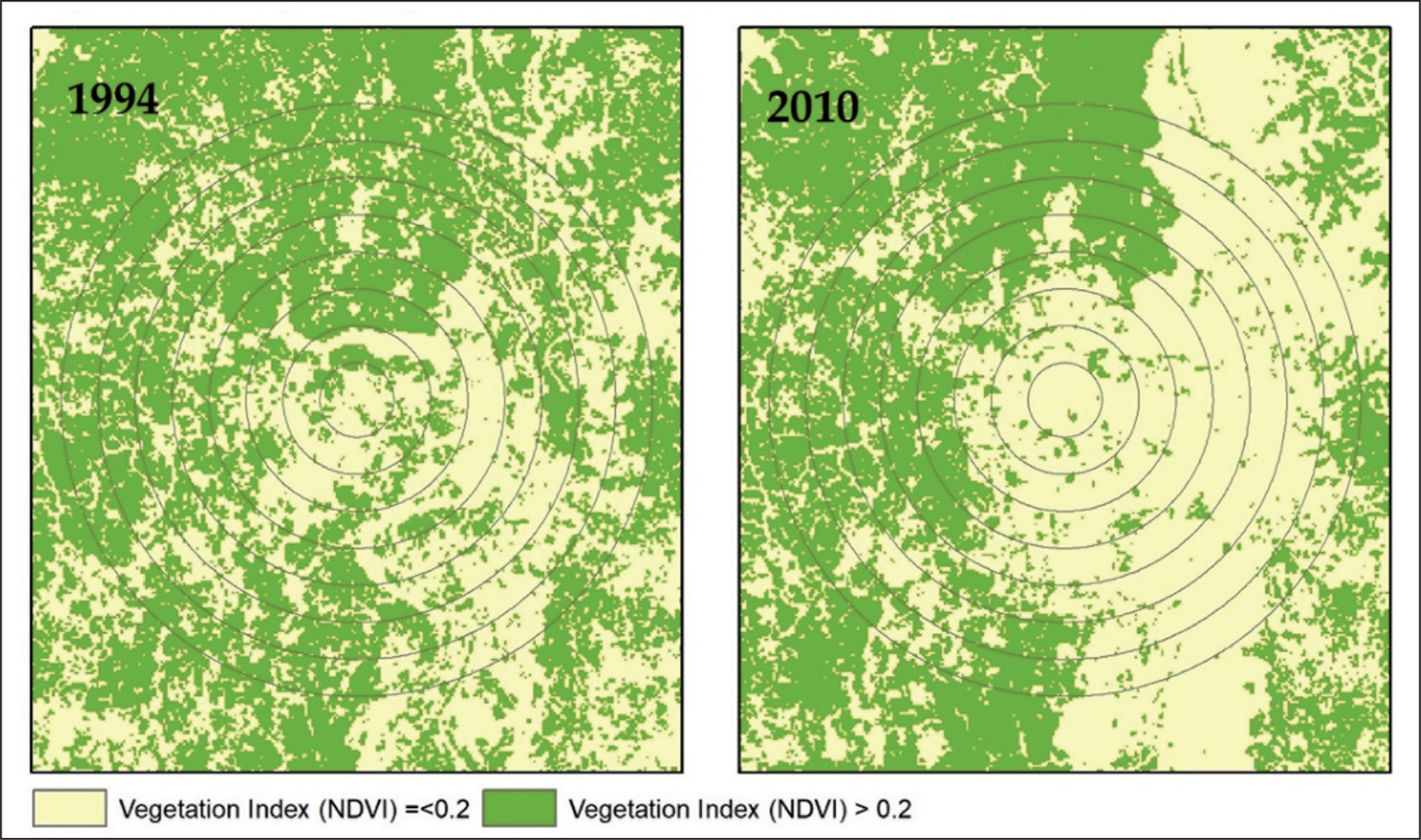
The study results show that natural habitats, that is, water bodies, vegetation coverage and open spaces have reduced significantly to accommodate growth
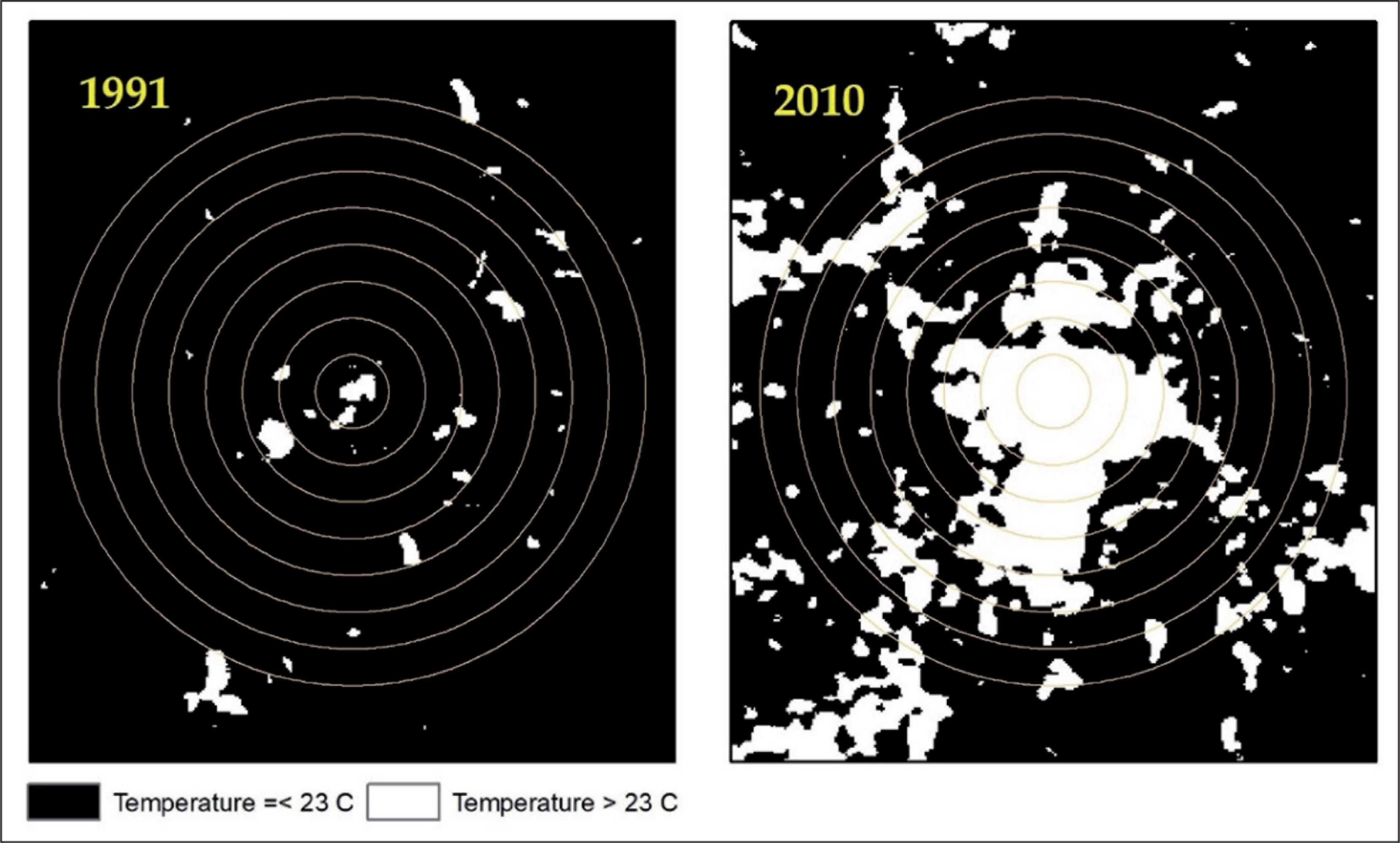
The index score of the air quality has decreased from 4.0 to 2.0 during the last decade, and the change is found to be significant (p = .000). Fine particles from industries, dust from construction works and roads are polluting the air. Besides this, odour from the solid waste disposal in open spaces, from the polluted water due to the discharge of toxic industrial effluents and from the overflow of sewerage makes it difficult to walk through some places. The increase in built-up land and high density creates an urban heat island (UHI) effect by increasing the local temperature in comparison to the surrounding area. Figure 5 shows how winter surface temperature has increased between 1991 and 2010.
Past and Present Condition Scores of the Components of the Liveable Environment with Statistical Significance
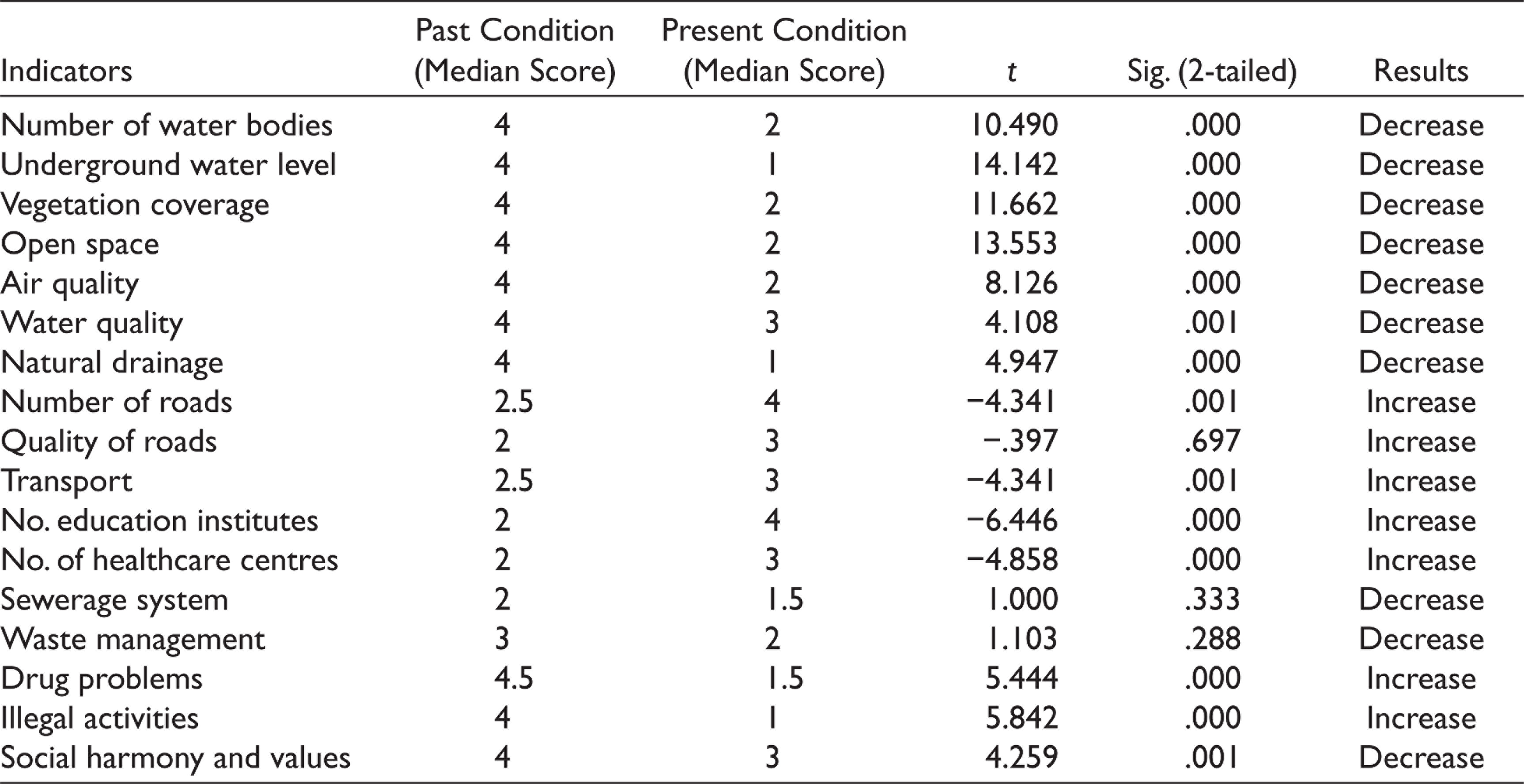
The water quality index has decreased from 4.0 to 3.0 during the growth period. Interviewees argued that both industrial and household waste pollutes surface water. Most of the industries do not have industrial effluent treatment plants, thus discharging toxic effluents to the nearby rivers and canals. On the other hand, solid waste generated from industries and household activities is also polluting the surface water because there is no waste management system in this area.
Furthermore, the waterlogging problem has become severe, especially in the central (Konabari) and northern (Ambagh) parts of the area. The drainage quality index has decreased from 4.0 to 1.0, and the change has been found to be highly significant (p = .000). In the past, there were natural drainage systems such as ponds, canals and rivers to drain out the stormwater or excess surface water. However, at present canals are disconnected, ponds are filled up for development, impervious surface covers land, and rainwater and even household waste gets waterlogged in some areas.
Increased Pressure on Infrastructure and Basic Services
The study found that the transport sector has been positively affected by growth, with the number of roads and transport services increasing alongside the growth of the population and economic activity. The quantity of road infrastructure index has increased from 2.5 to 4.0 and the transport services index has increased from 2.5 to 3.0. Although the transport infrastructure has improved in quantity, the quality of the infrastructure and services are still inadequate and insufficient to serve the growing population. The local industries use heavy vehicles to transport raw materials and finished goods, and roads are not strong enough to support heavy vehicles. Therefore, most of the roads are in a poor state of repair, and during the monsoon they become so muddy that it becomes almost impossible to walk on some roads. Transport services (modal) have improved in the private sector to provide commuting facilities and autorickshaws, minibuses and rickshaws provide intra-zonal services. On the other hand, there are some new services directly connecting this area to central Dhaka.
The number of education and healthcare institutions increased significantly over the last decade. The education infrastructure index increased from 2.0 to 4.0, and the health infrastructure index increased from 2.00 to 3.00. Both the education and health infrastructure increases are found to be highly significant (p = .000). Although the number of institutions is increasing, respondents do not seem happy with this because most of the institutions have developed privately, focusing on making a profit by utilizing the crisis of existing public institutions. They claim that most educational institutions are not registered and do not follow the teacher recruitment regulations. As a result, uneducated migrants have been exploited by such institutions. One interviewee commented that
You will find some teachers in those schools who completed only Higher Secondary level (Grade 12) but teaching in Grade 9 or 10. In the public institutions, even in the primary schools, you have to complete at least your bachelor to be a teacher. Therefore, the poor people who are working hard for a better future for their children are cheated by such poor quality institutions. I feel ashamed that we are failing to ensure a better education for the children of those immigrants who are fuelling the growth of our economy.
Increased Social and Community Problems
Community problems, especially relating to drug abuse, illegal activities and conflicts, have increased along with growth. One interviewee commented, ‘There is a popular term used here to describe the current society, “Five-M”, indicates Maal (money), Mod (drugs), Maagi (prostitution), Motorbike and Mastan (hooligans)’.
The study found that the index of the drug problem and illegal activities has increased during last 10 years. Many young people have become drug-addicted due to easier access to drugs. Moreover, the lack of guidance from families is also found to be an important factor in the intensification of drug problems. In most of the migrant families, many working adults work overtime to make ends meet. Therefore, they do not find enough time to look after their children during the day. Most of the time these young people are influenced by others and take up drug consumption.
Illegal activities, in particular, prostitution, has increased by targeting solo migrants (especially the unmarried or single garment workers). In this area, most of residential hotels are involved in such activities. The study also found that social bonds have weakened and personal conflicts have increased. Increased competition for earning and the increased value of land has been a cause for more conflicts and making people more focused on individual rather than community interests.
In the past us local people were living together, sharing our problems and joys. But now, when land becomes very precious, neighbours are becoming competitors. Many people clash with neighbours for land. No one is willing to provide land for access roads. They are now focusing more on their interests than community interests.
Conclusion
In conclusion, this study has shown that due to increased negative externalities in the core city area, labour-intensive and specialized firms, particularly the RMG firms, have been relocating to the urban peripheries or nearby suburban areas to enjoy large land parcels and minimum regulations. As this industry does not have a local market dependency, especially for finished goods, they can easily relocate to outside of the existing agglomeration. However, without regulations and controls, the relocation of such large firms brings severe social and environmental consequences in periphery and suburban areas. Based on the findings of the study we can summarize as follows:
Manufacturing industrialization has induced rapidly growing suburban areas demanding low-class and low-cost housing, which in turn encourages private individuals or landlords to develop slum-type settlements. Labourers are moving to such suburban areas (either from an existing centre or from rural areas) due to low living costs, minimum workplace-residence distance and high labour demands due to the continuous growth of industries. Being on the outside of the planned area, firms and individual private housing developers face minimum regulatory controls. Therefore, they are exploiting natural habitats and even the workers for their economic gain. Unplanned and uncontrolled development not only creates environmental degradation but also has a significant social impact. Poor people are selling their labour at a cheap cost for the betterment of their children’s future. However, the lack of quality education in the area fades this dream. Moreover, increases in social problems, especially relating to drug abuse, make young people more vulnerable.
There is clearly a requirement for government intervention where possible, which should be very proactive in planned urban development processes. The government must ensure a regional strategic plan where further industrial growth will restrict unwanted growth. Without such a strategy, the rapidly growing suburban areas will become a graveyard of development in the near future, with no options for reviving a better living environment. Moreover, there is a need for further studies on the spatial effects of different types of industrial firms in the residential development process. This will help authorities to understand how land should be allocated for firms as well as worker residences.
From a theoretical perspective, the study suggests the need for further studies to understand the suburban growth process in developing countries. The extant literature suggests that firms have benefited from agglomeration and specialization in existing growth centres (Friedmann, 1967; Hirschman, 1958; Krugman, 1991; Perroux, 1950). However, the study finds that key industries are localizing far from existing agglomerations, although infrastructural support is less adequate in these areas. Therefore, it is essential to investigate the factors that determine the localization of key (or specialized) industry sectors outside of the existing agglomeration. The study found that industrialization induced growth in the suburban areas forms a mixed-use urban ecology dominated by industrial and residential uses. Urban ecology models argue that land-rent determines the use of land, and the location of the central business district (CBD) and accessibility plays a vital role in determining land prices and rents (Duranton & Puga, 2015). However, there is no formal CBD in the suburban area, nor a retail centre. Growth is occurring in the surroundings of large industrial establishments. Therefore, studying the evolution of suburban land allocation determinants may provide a new dimension to theories of urban ecology. The study found that various informalities (either activities or the use of land) are associated with suburban growth. However, from this perspective, it can be assumed that different types of specialized industrialization may result in different processes and patterns of informal development. As informality is a common feature of development in cities in developing countries, understanding how informalities occur within specialized agglomerations demands further investigation.
Footnotes
Declaration of Conflicting Interests
The authors declared no potential conflicts of interest with respect to the research, authorship and/or publication of this article.
Funding
The authors received no financial support for the research, authorship and/or publication of this article.