



Abstract
The article attempts to understand the occurrence of climate-sensitive diseases in the Kuttanad Wetland Ecosystem, considering the backdrop of landscape changes. The study analysed the changes in the environmental landscapes of Kuttanad, which presumably had contributed to the disease epidemiology. The changes in the landscapes in terms of water bodies, land utilization, agricultural practices and other anthropogenic interventions were comprehended by employing the geographic information system and remote sensing approaches. Further, through oral histories, the perceptions of the local inhabitants about the changes in the ecosystem and disease epidemiology were captured. In the study, substantial spatial changes were observed in the wetland during the period 1990–2017. The development initiatives have created serious environmental damage and pushed the wetland into a state of ecological fatigue. The narratives from the field survey attribute the changes in the environmental landscapes as factors that contributed to the epidemiology of climate-sensitive diseases. Infectious diseases, mostly fever-type, assume epidemic proportions during the monsoon and create a feeling of trepidation among people due to their fatal and contagious characteristics.
I. Introduction
Human health and ecological factors have been linked since antiquity. Over twenty-four centuries ago, Hippocrates attributed different morbid conditions to weather and seasonal changes (Hannaway, 1993). Presently, there exist many substantial pieces of research that have scientifically analysed the complex association and interconnection of ecological factors like climate and weather on human health (Huq et al., 2005; Li et al., 1985; Steib & Mayer, 1988). The climatic variables are understood to influence the infectious disease patterns as the disease agents (such as viruses, protozoa, bacteria and fungi) and vectors (such as insects, mosquitoes and rodents) are susceptible to humidity, precipitation, temperature, rainfall and other ambient ecological conditions. The geographical distribution and seasonal changes in the occurrences of different infectious diseases are fine evidence to comprehend the sensitivity of the diseases to climate and other ecological factors (Ballester et al., 2003). Apart from determining the spatial and seasonal distribution of infectious diseases, the climatic factors also potentially influence the inter-annual variability of epidemics and their long-term trends (Kelly-Hope & Thomson, 2008).
The impact of the weather and climate affects infectious diseases in numerous ways. The ecology of the diseases, modes of infectivity, transmission processes are unique and complex for each disease and vary widely from one ecological setting to another. For instance, one disease may exhibit a different seasonal pattern in different ecological zones. Likewise, the local ecological instabilities that happen via climatic factors and other non-ecological factors tend to modulate the genetics of pathogens through mutation and horizontal gene transfer. These new interactions among hosts and disease agents foster threats through the emergence of new infectious diseases (National Research Council, 2001; Thomson et al., 2008). Therefore, the climate- or weather-induced impacts of infectious diseases must be understood in the background of different other factors that alter the disease dynamics, such as the land cover changes, socio-demographic factors, public health services, and others.
Although there are umpteen research studies that have attempted to link climatic variations and infectious diseases, most of these studies failed to fully capture the intricate web of causation that determines disease dynamics. It is because the relationship between climatic factors and infectious diseases is most likely dependent upon the ecology and local-scale parameters, and it is often challenging to meaningfully extrapolate these connections to broader spatial scales (National Research Council, 2001; World Health Organization, 2003). Thus, for any study on climate or weather-related diseases, an understanding of environmental epidemiology exploring the changes in local geography and disease epidemiology is fundamental. This helps in the better conception of the linkages between disease occurrence and resurgence with changes in the local habitat. By studying these associations and the underlying mechanisms, this article aims to comprehend the complexities involved in the spread of climate-sensitive diseases, particularly during the monsoon in the Kuttanad Wetland Ecosystem. Drawing from an extensive field survey, the study analysed the changes in the environmental landscapes of Kuttanad (due to natural and man-made processes), which presumably had contributed to the disease epidemiology. In India, though many epidemiological studies have been carried out to describe the dynamics of communicable disease transmission, the social and economic factors that have a bearing on the transmission of the disease, particularly in the environment and climate-sensitive areas, are least understood.
The subsequent sections of the article are structured as follows. Section II provides an elaborate depiction of the study area. In Section III, the methodology adopted in the study is discussed, encompassing an outline of the fieldwork. Section IV provides the results and discussion, followed by a conclusion in Section V.
II. Study Area
The Kuttanad Wetland Ecosystem lies on the southwest coast of the Indian peninsula and belongs to the largest Ramsar site in India, the Vembanad-Kole wetland. The region is a deltaic trough geologically formed and shaped through the confluence of four major rivers in Kerala, namely, Manimala, Pampa, Meenachil and Achenkovil that flow through the wetland before debouching into the Vembanad backwaters (Chandran & Purkayastha, 2018). The topographical characteristics of the wetland are unique, as the core region lies between 0.5 and 2.2 metres below the average sea level and is water-logged for most part of the year. The marshy and low-lying nature often subjects the region to severe flooding during the monsoon and saltwater ingression during the summer (Sylas, 2010).
The total geographical area of the ecosystem is 1,157 km2 and is spread across three districts in Kerala, namely Alappuzha, Kottayam and Pathanamthitta. The ecological uniqueness of the wetland aids in delivering a broad array of ecosystem services and is home to a variety of flora and fauna (Aravindakshan & Joseph, 1990; Kumar & Devadas, 2016). The region exhibits humid tropical climatic features with an annual temperature ranging between 21°C and 36°C. The recorded annual rainfall in the region is around 3,250 mm, mainly contributed by the two seasons of monsoon. About 60% of the rainfall is received during the southwest monsoon (May–August) and 30% during the northeast monsoon (October–November) (Sreeja et al., 2015; Sreejith, 2013). Based on the geomorphology and agro-ecological characteristics, such as the mean height from sea level, risk of flooding, saltwater intrusion levels, the impact of rivers, cropping patterns, soil type, and fertility, the wetland is divided into six agro-ecological zones (Indo-Dutch Mission, 1989).
The wetland is a very complex rice-cultivating agro-climatic tract. The farming system in Kuttanad is unique as it is the only region in the country that practices paddy cultivation below the mean sea level. The region accounts for 25% of Kerala’s total rice grown area and contributes around 37% of the state’s total rice production (MSSRF, 2012). Most of the fields under paddy cultivation are reclaimed delta swamps around Vembanad Lake. Apart from paddy cultivation, the inhabitants of the wetland engage in agriculture-allied activities such as inland fishing, duck rearing and mussel gathering. The region is also known for coconut cultivation and toddy tapping (Vallikappen, 2012).
Presently, the wetland is under serious threat due to environmental degradation arising from numerous development initiatives and rapid urbanization. The spatial and temporal features of the ecosystem have undergone a rapid change, which has led to a number of environmental and public health issues. The anthropogenic activities disregarding the sensitivity of the wetland, such as the unplanned construction of roads, reclamation of the lake area, uncontrolled encroachments, discharge of organic and fertilizer wastes, intensive agriculture practices, booming tourism, have altered the uniqueness of the wetland and contributed to the ecological deterioration of the hotspot (MSSRF, 2007). The region is showing signs of ecological decay due to the mounting anthropogenic pressure through the loss of flora and aquatic fauna, increased intensity of flooding, water pollution and severity of infectious diseases (Sreejith, 2013).
III. Methodology
This article attempts to understand the occurrences of climate-sensitive diseases (vector-borne and water-borne) in the background of the geographical changes that have taken place in the study area. The changes in the geography of the Kuttanad Wetland Ecosystem in terms of water bodies, land utilization, agricultural practices and other anthropogenic interventions were comprehended by employing the geographic information system (GIS) and remote sensing (RS) approach. The RS technique normally involves the application of satellite images of two or multiple dates to examine the land use changes in an area. In this study, to check for the changes in the land use patterns of the region, a Landsat 7 satellite image of the Kuttanad Wetland Ecosystem for the month of March has been downloaded for the year 1990, and a Landsat 8 satellite image of the same for the month of March 2017 has also been downloaded. The satellite images for the two years have been processed and compared using ERDAS Imagine. One of the classification techniques, such as supervised classification, is extensively used to check the temporal changes in land use. Further, the perception of the local inhabitants regarding the changes in the geography of the region and its linkages to disease epidemiology were traced through oral history methods. A total of 21 elderly inhabitants from Lower Kuttanad were extensively interviewed to document their oral histories. Among these individuals, 11 were previously engaged in the indigenous occupations of the wetland (paddy cultivation, duck rearing, in land fishing, mussel gathering and toddy tapping). Additionally, the group of key informants contributing to this study extended beyond indigenous occupation-based participants to include 10 other senior inhabitants (one general practitioner, one local pharmacist, three social activists and five casual workers belonging to non-agriculture backgrounds). The narratives from the field visits helped in understanding the changes in land use and their linkages to disease epidemiology. It also helped in tracing the signs of ecological degradation in the region, which presumably have contributed to disease occurrence and resurgence. The fieldwork was carried out between January 2018 and March 2019. Though the study attempted to understand the environmental history and geographical changes of the entire Kuttanad wetland, the field visits were restricted to 11 villages in the Lower Kuttanad region as this region faces comparatively higher risks of monsoon flooding, saltwater ingression and infectious diseases.
IV. Results and Discussion
Land Use Changes
The deltaic wetlands of Kuttanad are considered very vulnerable to anthropogenic pressure due to their unique geographical setting. The wetland is situated at the gateway of the river basins and has a very delicate estuarine ecology. The major part of the Kuttanad Wetland Ecosystem (around 57%) lies in Alappuzha, a district with one of the highest population densities in the state (Government of India, 2011). Therefore, due to the region’s dense habitation, the wetland experiences severe pressure on natural resources. The extensive land reclamation and unplanned construction of roads, buildings and other commercial establishments have divided the region into tiny fragments and altered the free flow of water in many places, resulting in stagnation and water-logging. The wetland has undergone serious changes in geography and land use over the period of years. Many such changes in the land cover have resulted in unfavourable impacts on the ecosystem and contributed to the perennial environmental problems in the region, such as flooding, water pollution, outbreaks of infectious diseases and declining aquatic biodiversity (MSSRF, 2007; Sreeja et al., 2015).
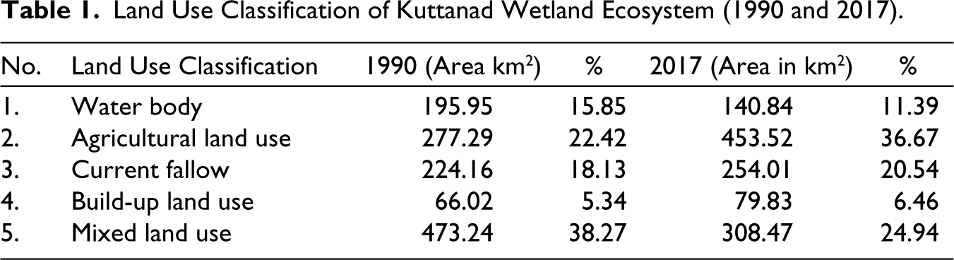
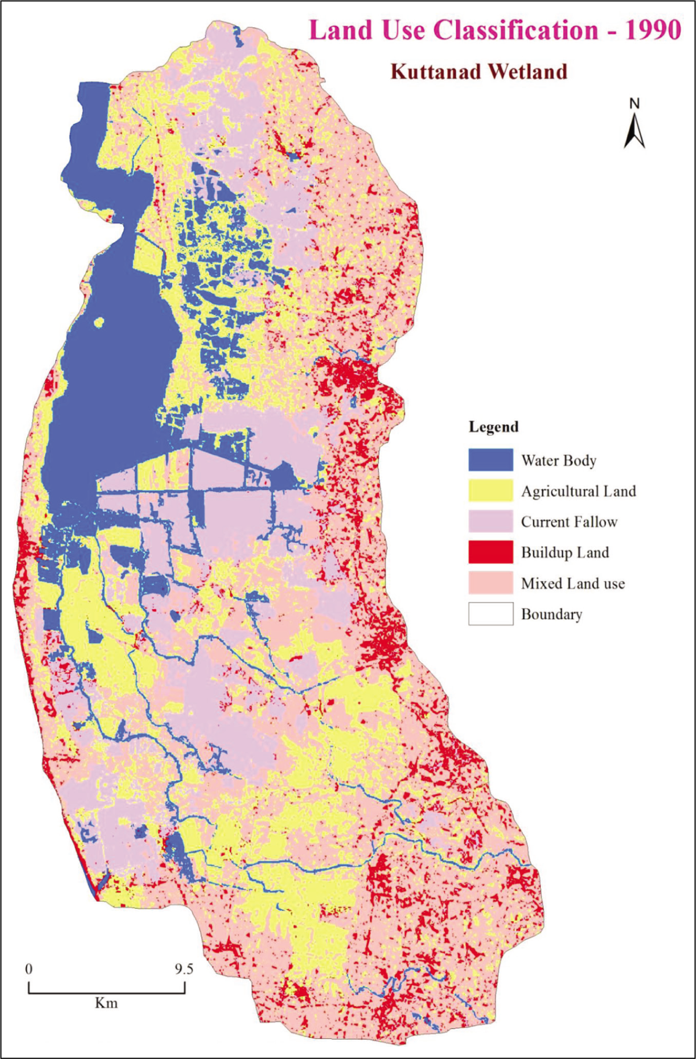
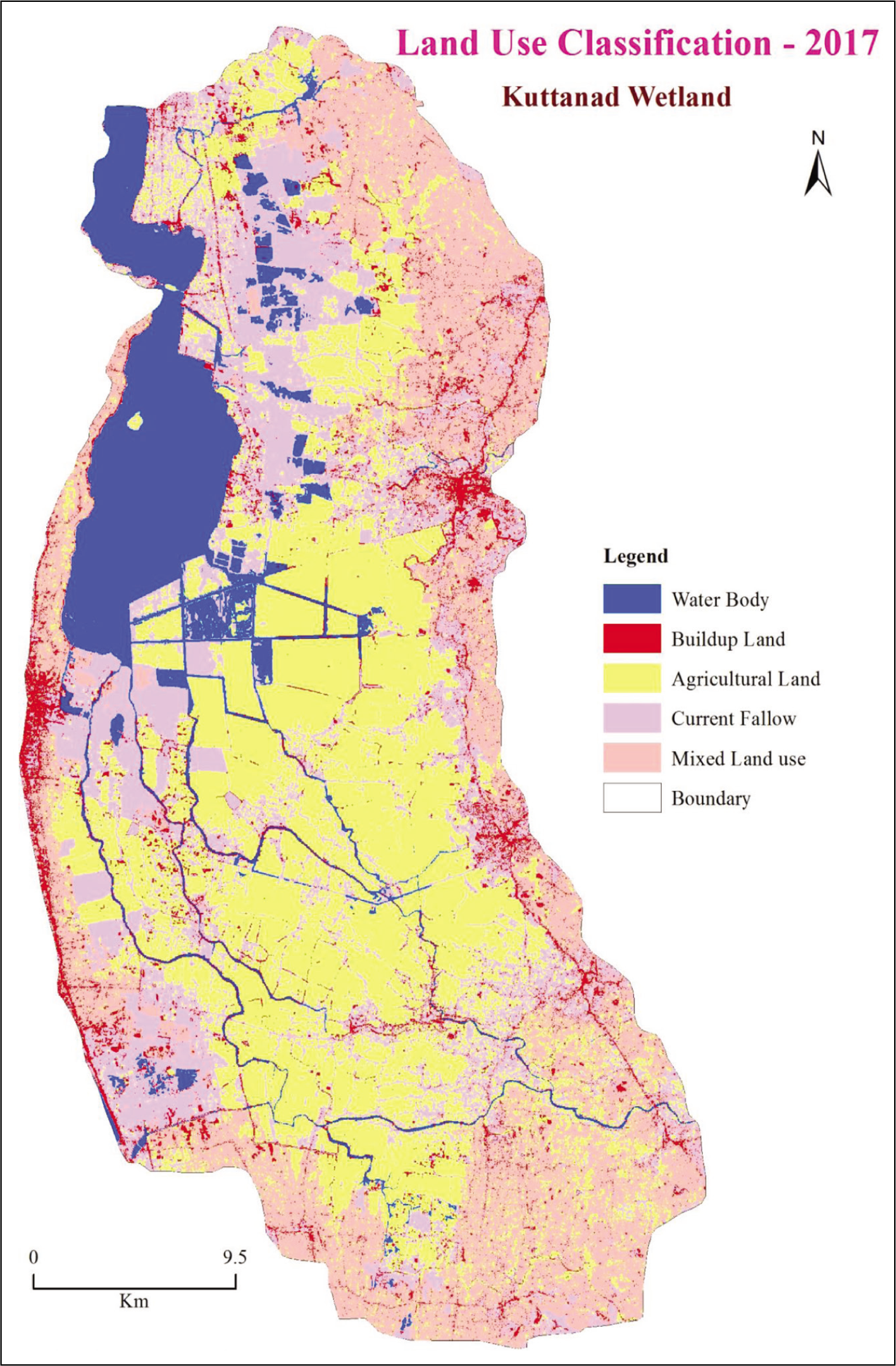
In the study, the land use changes were captured using satellite images. For the analysis, the region was classified into five categories, namely water bodies, agricultural land use, current fallow, build-up land use and mixed land use. The area in square km for each category and its share in the total land mass for two years 1990 and 2017 are shown in Table 1. The analysis helps in understanding the temporal changes in the land cover of the study area. The results reveal a considerable change in the land use pattern over the span of 27 years in the region. The mappings of the land use classification for 1990 and 2017 are presented in Figures 1 and 2, respectively. The two key findings reflected in the spatial change analysis are the shrinkage of water bodies and the increase in the coverage of agricultural land use. Further, a slight increase in the total current fallow and build-up land use were observed in the analysis. It is unknown how much of the water bodies and agricultural land were converted into build-up areas.
Land Use Classification of Kuttanad Wetland Ecosystem (1990 and 2017).
Shrinkage of Water Bodies
In 1990, the water bodies in the Kuttanad wetland were spread across 195.95 km2 comprising 15.85% of the total wetland. The total area of the water bodies in the wetland was reduced to 140.84 km2 in 2017, with a decline of 4.46% in the total area during the 27-year period (Table 1). A previous study by Roopa and Vijayan (2017), which attempted to analyse the changes in the spatial extent of Vembanad Lake, also found significant depletion in the total lake area.
Uncontrolled human encroachments, large-scale reclamation of the Vembanad Lake and forced efforts to raise the lakebed through siltation were the major causes that led to the shrinkage of water bodies in Kuttanad. Agriculture (mainly paddy cultivation) was the prime reason for most of the reclamations in the Vembanad Lake until the 1980s. Later, the booming of tourism in the 1990s, centred around the backwaters in the wetland, contributed to the shrinkage of water bodies. The swift growth in Kuttanad backwater tourism had paved the way for the mushrooming of the tourist resorts and homestays. All such establishments were built targeting the water bodies in the wetland, which led to an increase in the encroachment of the lake area. It is estimated that the flood-carrying capacity of the Vembanad Lake was reduced by 78% due to the decrease in the area and depth of the lake (MSSRF, 2007).
The land reclamations in Kuttanad initially started in the 1830s during the colonial period with the sole objective of addressing the problem of food scarcity. The reclamation efforts were envisioned to increase paddy production, bringing in more land under cultivation. In the initial phases of reclamation, the Government of Travancore supported the farmers for reclamation in the Vembanad estuary for agriculture purposes (Gopalan, 1984). It is estimated that a total of 23,104.87 hectares were reclaimed in Kuttanad, mostly for carrying out agriculture, between 1834 and 1984. The reclamations during this period resulted in the horizontal shrinkage of Vembanad backwaters by 63.29%. The backwaters were also subjected to vertical shrinkage due to heavy siltation and dredging. It is estimated that the average depth of the Vembanad Lake was reduced to 4.4 metres from 6.7 metres, consequently aggravating the intensity of flooding in the region (Chandy, 2013; Padmakumar et al., 2002).
Apart from land reclamation and the commercialization of tourism, other anthropogenic interventions such as urbanization and the rapid increase in the establishments of human settlements have also accelerated the shrinkage of water bodies and put the wetland under severe environmental pressure.
Changes in Agriculture Land Use
The present study found a substantial change in agricultural land use between 1990 and 2017. The total agricultural land use increased from 277.29 km2 (22.42%) in 1990 to 453.52 km2 (36.67%) in 2017 (Table 1). The commercialization of agriculture and increased mechanization post-1990s in Kuttanad were the major reasons for the increase in agricultural land use during the study period. The subsistence farming practiced in the region before the 1990s was replaced through large-scale commercial operations and improved mechanization. The agriculture advancements post-liberalization facilitated intensive and extensive farming of high-yielding paddy varieties, the entry of harvesters and the application of agrochemicals and fertilizers. The agricultural developments coupled with the backing from the state government made paddy cultivation lucrative, encouraging more farmers into the business (Thomas, 2011).
The support and thrust from the state government since the 2000s have expedited the pace of rejuvenation in paddy farming. There was a sharp decline in the total area and production of paddy in Kuttanad due to falling crop prices and labour issues in the late 1990s. The government made deliberate efforts to re-establish paddy farming in the region by ensuring profits for the farmers (Thomas, 2002). The government formulated policies to grant relief to the farmers in debt and stabilize agricultural prices to increase productivity and farm income. Apart from relief packages for debt, the government also facilitated the distribution of seeds and fertilizers at a subsidized rate. Further, in 2009, the state government proposed a package solely for paddy cultivation that aimed to support a range of activities, from seed production and paddy procurement to soil and water conservation (Government of Kerala, 2006, 2009). Thus, the large-scale commercialization of agriculture, improved mechanization and support from the state government stimulated the growth in agriculture land use in Kuttanad post-1990s.
Before the technological advancements in agriculture, the paddy cultivation in Kuttanad was ‘ecologically-based’. There was only a single crop cultivated in an entire year. The rice farming operations were completely dependent on the local hydrologic cycle. The fertilizers were mostly organic in nature, and the soil fertility was largely based on the natural cycles. The paddy fields were left fallow between the cropping seasons to regain their natural soil fertility. The cultivated rice varieties were purely indigenous, which sticks to the local ecological system and requires less manuring (Jacob et al., 2018; MSSRF, 2012). However, with the development of technology and improvements in farming methods, the indigenous agricultural practices of the wetland have gone extinct over time.
An 80-year-old former paddy worker from Champakulam village narrates the erstwhile practice of pest removal from the fields:
Back then, we had traditional ways to remove pests that infect our crops. We drive water into the fields to float the pests. By taking turns, we remove them with big wicker baskets and rags. We carried out this process twice a day, morning and evening. It was challenging and tiring. We have also tried organic pest control measures using extracts from different leaves. Today, everything is easy. The currently available pesticides quickly eliminate the pests.
The strenuous and continuous cropping practices in the region have increased the injudicious usage of pesticides and chemicals, leading to the degradation of the soil quality. The shift to double-cropping has altered soil properties by depleting the nutrients and organic matter and also by increasing the acidity and accumulation of heavy metals (Thampatti & Padmakumar, 1999).
A 67-year-old former paddy worker from Lower Kuttanad observes the impact of double-cropping on the wetland:
The double-cropping practices have ruined our land. Undoubtedly, it has increased rice production but at the cost of our ecosystem. Double-cropping has decreased the intervals between the cropping seasons. With the new seed variety, we hardly get any gap between the seasons. This is not conducive for the paddy fields. The fields should be left fallow for some more time. Double-cropping requires double application of pesticides and chemicals, which is hazardous. Whatever we put or pour into the fields end up reaching our water bodies. That is nature’s law. More poison we pour into the fields [referring to the application of pesticides], more poison reaches our water bodies. We have a severe scarcity of drinking water in Kuttanad because of the double-cropping patterns. Now, people here drink contaminated water and fall sick. There is an escalation of diarrhoea and other water-related diseases in our region. It was not the case many years ago.
The changes in the agriculture practices in Kuttanad have wreaked havoc on the ecosystem. The switch to a double-cropping pattern and the intensive application of agrochemicals and pesticides have produced many public health and environmental issues in the region. Injudicious agriculture practices have pushed the level of toxic pollutants in the water bodies, thereby raising threats to aquatic flora and fauna. The increase in water pollution levels has also aggravated the problem of a lack of access to safe drinking water. The households’ dependence on contaminated water has resulted in the sprouting of water-borne diseases in the wetland.
Public Health Issues
The anthropogenic interventions hindering the tranquillity of the ecosystem of Kuttanad have created precarious and outrageous public health issues in the region. The wetland has turned into a nursery for pathogens and parasites that spread infectious diseases, both vector-borne and water-borne. The trepidation of epidemics sprouted in Kuttanad with the occurrence of Japanese encephalitis (JE) in the mid-1990s. Kuttanad faced a rampant outbreak of encephalitis in early 1996, with 105 reported cases and 51 deaths. The high fatality rate of the disease has generated severe panic in the wetland (Balakrishnan et al., 2017). After JE, the first major outbreak happened in the region when chikungunya surfaced in Kerala in 2006. Kuttanad and other parts of Alappuzha were among the most affected regions of the state. In the year, a total of 58,308 suspected and 16 confirmed cases were reported from the district. The severity of the outbreak increased in the subsequent year, with 110 confirmed cases. The district was also terribly affected during the H1N1 influenza outbreak in 2009. During the period 2009–2011, 180 cases and 6 deaths were reported in the district due to H1N1 (IDSP, 2011).
In addition to communicable diseases, the wetland is on high alert with the rising incidence of cancer diseases. A joint study conducted by the Department of Community Medicine of the Alappuzha Government Medical College, the Prevention of Epidemics and Infectious Diseases Cell and the State Disease Control and Monitoring Cell in the Kainakary villages of Lower Kuttanad found dire prevalence rates for cancer diseases. The prevalence rate of cancer diseases in the villages stood at 6.3 per 1,000 persons, which is close to three times the national average (Mathew, 2010). Preliminary findings of previous studies presumably point out the excessive application of chemical fertilizers and pesticides as the major cause of the high cancer prevalence in the region (Ajayan, 2009; Chandy, 2016).
Apart from disease threats, another perennial public health issue in the wetland is the lack of safe drinking water. The abandonment of freshwater ponds, water pollution due to the discharge of sewage wastes, excessive application of pesticides, saline water intrusion and the decline in the water table have deteriorated the quality and quantity of drinking water sources in the region. Frequent floods and the lack of access to safe drinking water have increased the occurrence of water-borne diseases such as acute diarrheal diseases (ADD), leptospirosis and hepatitis fevers in Kuttanad. The wetland has also witnessed the resurgence of cholera during the 2009 monsoon (DHS Kerala, 2009).
The decline in the quality of water from natural sources has affected the areas in Kuttanad where piped water supply is irregular. The most affected are the Kainakary villages. Reports reveal that around 80% per cent of the households in Kainakary depend on contaminated canal water for drinking and other domestic purposes (Sudheesh, 2017). The lack of access to safe drinking water is the major reason behind the increase in gastrointestinal and diarrheal diseases in Kuttanad.
According to a 76-year-old respondent from Kainakary:
Since the public tap water facility got disrupted, we use boiled canal water for drinking and cooking. The health department people have warned us against the use of canal water as we have fallen ill with diarrhoeal diseases several times. Even we are aware that the water from these channels is not ideal for consumption. But we have no choice. Like others, we cannot afford to buy the big plastic water [referring to the 20-litre plastic canned drinking water].
The public health situation in Kuttanad is in a precarious situation with an increasing assault on the local habitat. The neglect given to the natural water sources has a grave impact on the livelihood of the local inhabitants. Therefore, multiple governmental interventions are required to restore the ecological balance and address the public health issues in the wetland.
Signs of Ecological Impairment
Anthropogenic interventions in the wetland have created exigent environmental issues and pushed the ecosystem into a state of an acute ecological crisis. The indiscriminate exploitation of natural resources, increasing levels of pollution, alterations in the land use pattern, rapid urbanization, deleterious agriculture practices and inordinate tourism operations in the region have massively affected the ecological balance of the wetland. This has led to major environmental challenges, such as biodiversity loss and a decline in ecosystem services. The erstwhile and genetically diverse ecosystem of Kuttanad has been showing vital signs of ecological impairment through depletion of fish habitats and varieties, recurring avian influenza outbreaks, dwindling bird population, degradation of water quality in the natural sources, increased intensity of floods and mounting public health issues.
The duck-rearing farmers in Kuttanad attribute faulty agriculture practices and declining water quality as prime reasons for avian influenza outbreaks. A 65-year old farmer narrates:
I blame the paddy cultivation in Kuttanad as the major reason for all these problems [referring to the avian influenza outbreaks]. The excessive use of poisonous pesticides has ruined the water quality in the region. All the chemicals are getting drained directly to the water sources. The water almost changed to look like oil. No wonder why ducks get so many infections and diseases these days.
Similarly, increased man-made interventions and consequent degradation of the ecology have negatively impacted the fish fauna of Kuttanad. This has pushed the traditional inland fishermen community of the wetland into a state of misery. In addition to the fishermen community, the depletion of the shellfish resources due to intensive dredging operations and widespread encroachments of the lake area has adversely affected the livelihoods of the traditional mussel gatherers and clam diggers in Kuttanad.
Previous studies reckoned the operation of the Thanneermukham saltwater barrier as one of the major factors that led to the elimination of many fish species. The barrage disrupted the hydrology of the ecosystem by regulating the saltwater intrusion into the lake. This had a direct impact on the breeding patterns of many fish species and resulted in their gradual extinctions (Asha et al., 2014). The physical obstruction caused by the barrage also affected the prawn population in the inland water bodies. The yield of prawns had reduced by 15 times post the closure of the barrage (Kurup et al., 1998). Besides the cascading effect of the saltwater barrier, excessive application of pesticides and agrochemicals, erroneous fishing practices, massive elimination of mangroves, and improper waste disposal had also resulted in the loss of natural habitats for the fish species in the region (Kumar & Rajan, 2012).
Response of an inland fisherman on the declining fish count in the inland water bodies of Kuttanad (75 years):
There is no doubt that the fish count has reduced in the inland water bodies. Fishes like naadan mushi [a type of cat fish], arakan [spiny yeel] and kanambu [mullet] are rarely seen these days. Our daily catch has reduced to one-third compared to 15–20 years ago. Kallu kettu [construction of embankments] has disturbed the fish breeding. Also, the paddy cultivation and houseboat tourism has degraded the water quality in the channels. It is not surprising to see the fish count declining day by day.
The ecological impairment has odious effects on the livelihoods of the people in Kuttanad. Most of the wetland inhabitants rely on indigenous occupations that have direct or indirect linkages to the ecosystem services. For instance, the decline of fish habitats adversely affects the livelihood of the inland fishermen in the region. Similarly, avian influenza outbreaks will put the lives of duck-rearing farmers in peril. Henceforth, it is important to make calibrated efforts to conserve the wetland to ensure the restoration of the ecosystem services.
Perceptions of Fevers
The pattern of communicable diseases in Kerala is undergoing a change manifested with the emergence of new diseases and the resurgence of previously contained diseases (Rajesh & Thomas, 2012). The epidemiological situation in Kuttanad is also no different and has witnessed recurrent outbreaks of JE, malaria, leptospirosis, dengue and chikungunya since the 1990s. These infectious diseases, mostly fever-type, assume epidemic proportions during the monsoon and create a feeling of ‘fear’ among the people due to their fatal and contagious characteristics. This study has attempted to capture the fear of fevers in the region and how it has shaped the individuals’ responses to disease preparedness and disease management.
The nature and characteristics of most infectious diseases present fever as the major clinical feature (González Plaza et al., 2016). The initial signs and symptoms also align with common viral fevers during the monsoon. People often tend to misperceive the initial infections, perceiving them as common monsoon fevers. For instance, the first outbreak of H1N1 in Alappuzha and Kuttanad happened during the monsoon, with most cases reported in the month of August (IDSP, 2011). Influenza exhibited symptoms similar to common fever-type illnesses that occur in the state during the monsoon. Likewise, the resurgence of cholera during the 2009 monsoon appeared with symptoms closely aligning with common diarrheal diseases. Although there are similarities in the presenting symptoms of fatal infectious diseases with common monsoon fevers, the nature of infectivity and the virulence of such diseases are disparate.
Henceforth, the perceived ‘naturalness’ associated with monsoon fevers is gradually breaking in people’s minds with the recurring outbreaks of infectious diseases and their confounding symptoms. The newly acquired ‘fear’ of fevers has made people cautious about falling ill during the monsoon. It is reflected in their treatment-seeking behaviours with improved utilization of healthcare services. For instance, a 61-year-old man who runs a pharmacy in a Lower Kuttanad village for over 25 years observes the change in the mindset of the people with the over-the-counter purchase of medicines:
People are now terrified of fevers during the monsoon. See, now you cannot say which fever is what. So everyone has become very cautious. The attitude itself has changed. Earlier, like some ten or twenty years back, many people purchased medicines for fever without any doctor’s prescription. They come here, describe their symptoms, get their medicines and leave. This trend is changing. Now, most people come with a doctor’s prescription. I feel the habit of self-diagnosis and self-treatment has reduced these days. They have started to visit primary health centres and clinics for fevers.
Further, people perceive a transition in the occurrence of monsoon fevers with variations in intensity and severity of the diseases over the years. For example, an 80-year-old former agriculture labourer from a Lower Kuttanad village recalls the prevalence of various diseases during the monsoon in the past:
When we were young, there were only common colds and diarrheal diseases during the monsoon. It was never a serious issue back then. We relied on home remedies and never bothered to visit naattu vaidyan [traditional healer]. Now you see, everything has changed. Everybody frequently falls ill during the monsoon—scarily different types of fevers and different kinds of symptoms. Something which was considered trivial has become very frightening now.
In addition to the emergence of new fever-type diseases, there is also a perceptible change observed in the symptoms people experience for fevers in the region. For instance, a senior general practitioner observes the change in the signs and symptoms of fevers over the years (male, 73 years):
Till some years back, people with fever could tell me their precise symptoms of illness. Apart from high body temperature, they specifically say sore throat, runny nose, coughs etc. Now, it is strange to see many patients fail to convey their fever symptoms. This usually happens during the monsoon. Besides the common symptoms, they say they suffer from ‘irritations’ or ‘uneasiness’ which they often fail to elucidate. Also, now most fever patients report extreme fatigue as a symptom that was not this common.
Similarly, a 66-year-old senior inhabitant of a Lower Kuttanad village observes the changes in the fever characteristics:
Earlier, fevers used to get over within two or three days. Now, whatever the type of fever, it affects the body for many days. Even though major symptoms settle down, we will feel very weak for weeks. In some cases, months. I feel the home remedies are also not that effective against the fevers these days.
Previous studies have attributed changes in the landscape as an important factor that led to the upsurge of infectious diseases in the wetland. For example, the outbreak of JE has been associated with the proliferation of Culex vishnui mosquitoes in the affected areas. In Kuttanad, studies have linked the proliferation of mosquitoes with the uncontrolled growth of waterweeds that increased considerably after the commissioning of the Thanneermukham saltwater barrier in 1976 (Kumar, 1996). Likewise, the man-made blockages in the natural waterways due to various development initiatives have resulted in the formation of many breeding sites, which expedite the spread of infectious diseases in the wetland. The region has also witnessed a rise in the occurrence of leptospirosis due to an increase in the rodent population as a result of the existence of vast fallow paddy fields. The respondents in the present study have reckoned the impact of the changes in land use as one of the major reasons for the proliferation of infectious diseases in the region.
According to a 74-year-old respondent:
The neglect of water bodies is the root cause of all the diseases in Kuttanad. See the state of ponds in these areas. Nobody needs ponds now. So, it has become like a dumping site. Along with waterweeds, you can find all kinds of wastes. The ponds and other water channels now belong to the mosquitoes. During the rainy season, they breed and spread dengue and other diseases. Or else, how could there be many diseases now and not then, say 30 or 40 years back. The ponds and water channels were not polluted then. That is the reason.
The respondents in the study have identified the spread of leptospirosis in Lower Kuttanad with monsoon flooding and agricultural land use. Earlier, studies have linked the propagation of leptospirosis with changes in agriculture practices, geographical conditions and climatic features. The changes in agricultural land use and management alter the distribution of pathogens and the risk factors associated with leptospirosis (Escamilla et al., 2007; Hernández-Rodríguez et al., 2017). Similarly, the humidity conditions, rainfall patterns and the intensity of flooding influence the prevalence of leptospirosis (Evangelista & Coburn, 2010; Hartskeerl et al., 2011). Kuttanad has undergone major changes in agricultural practices and land use patterns over the years. Moreover, the presence of puddles, lagoons, stagnant water bodies, patches of fallow paddy fields and frequent flooding provide ideal environmental conditions for leptospirosis transmission in the region.
According to a 69-year-old respondent:
Rat fever [leptospirosis] gets spread in these areas after the monsoon flooding. People are likely to get infected when they clean their houses aftermath the flooding. Similarly, people who live very close to abandoned or fallow paddy fields, blocked canals and drainage lines also get affected. Rats live and contaminate the soil and water in those areas. The floodwater flows through the contaminated fields or canals and enters the houses, infecting people.
Leptospirosis is often considered an occupational disease and is identified to affect specific risk groups who work in surroundings prone to infestation with rodents, which are the primary reservoir hosts of the disease. Some of the populations at risk include agriculture workers, miners, inland fishermen, sewage maintenance workers, etc. (Guerra, 2013; Mgode et al., 2015). A similar pattern in the occurrence of leptospirosis has been identified in Lower Kuttanad, with most cases reported among paddy workers, canal desilting labourers and inland fishermen.
The predictability of disease occurrences with identified risk groups, seasonal and geographical patterns aids institutional preparedness and control measures (Goarant, 2016). In Kuttanad, with the seasonal patterns and risk groups identified for leptospirosis, the geographical patterns can be predicted by employing risk mapping through spatial analysis. The geographical approach to risk mapping includes the accounting of the changes in the landscape and land use that directly or indirectly contribute to disease transmission. This approach can also be used in the prediction of geographical patterns for other infectious diseases. For instance, marking congenial mosquito breeding sites helps in the planning of control measures against mosquito-borne diseases.
The geographical mapping of disease incidence and risk factors has become very important in the fields of public health and epidemiology (Koch, 2005). The mappings foster an understanding of social and environmental determinants in the spread of infectious diseases. In the present study, an attempt was made to comprehend the working of Ward-level Health and Sanitation Committees of Lower Kuttanad in carrying out their pre-monsoon preparedness measures. The committees are involved in the preparation of community-based mappings of the wards to facilitate disease surveillance and sanitation drives. With the help of community knowledge, the committees prepare sketch maps of the wards, covering the roads, water bodies, drainages, pathways, canals, scrublands, paddy fields and other landmarks. The maps identify plots with potential sanitation issues and aid in vector control and source reduction activities. Also, with the involvement of public health volunteers, the committees gather disease data and mark critical hotspots for carrying out containment measures to prevent recurring outbreaks.
According to a member of a Ward-level Health and Sanitation Committee:
The mapping we prepare is very practical and inexpensive as we do not rely on any electronic devices. With the support of local people, we identify specific locations of potential public health threats like abandoned ponds, blocked drainages, scrublands etc. Once the mapping of the ward is complete, we instruct our volunteers of the vector control programmes to carry out source reduction activities in those areas. Though the procedure is convenient, there are chances of missing some places as the mapping is done manually.
It is true that community-based mappings irrefutably expedite epidemic preparedness efforts by leveraging local knowledge. However, operational challenges persist due to a lack of technical and scientific expertise among the volunteers involved in such participatory exercises. The increasing errors while expanding the mapping scales and the absence of fidelity in the assessment of maps result in inaccurate precision (Dongus et al., 2007; Saran et al., 2020). The advancements in information and geospatial technology have improved the accessibility and reliability of interlinking disease data and mapping processes. The application of GIS and RS technologies has helped public health researchers integrate health, population and environmental data. This has assisted in evaluating and quantifying the association between environmental and health-related factors at different geographical scales (Fletcher-Lartey & Caprarelli, 2016). The epidemiological mapping of the region using geospatial technologies facilitates disease surveillance, outbreak prediction and cluster detection.
In Kuttanad, where the threats of outbreaks are persistent, the application of geospatial technologies has a huge possibility in the execution of disease control programmes. These techniques can play a decisive role in various aspects of preparedness, including visualizing and presenting disease data, pinpointing clusters, conducting disease surveillance, estimating distances to assess healthcare accessibility and conducting spatial analyses to understand correlations between health outcomes and potential causal factors like environmental contamination (Beyer et al., 2010). Utilizing such tools stands to significantly strengthen efforts aimed at safeguarding community health and mitigating the risks posed by infectious diseases in the wetland.
V. Conclusion
A rigorous and nuanced understanding of the changes in the geography of a region is vital in studying the drivers of weather-induced diseases. The environmental narrative, especially regarding alterations in the landscape, holds significant relevance for research aiming to understand the environmental epidemiology of infectious diseases. In environment-sensitive hotspots, the disease patterns are stimulated by landscape changes, mostly through man-made processes, and occur at various spatial and temporal scales depending on the biotic and abiotic factors. Land use and vegetation cover alteration are two assessments of landscape change that can be scientifically studied by employing geospatial technologies. However, the valuation of land cover changes is often inept at explaining the patterns of infectious diseases due to the complex nature of the transmission cycles. More specific ways to understand the geographical distribution of diseases, such as an exploration into the perceptions of the local people living in specific regions, add to the empirical richness of environmental epidemiological studies. In this research, such a framework was critical in shedding light on the discursive interpretations of diseases by delving into the environmental history of the study area.
The Kuttanad Wetland Ecosystem has undergone spatial changes over the period of years. The development initiatives in the wetland have created serious environmental damage and pushed the ecosystem into a state of ‘ecological fatigue’. The injudicious exploitation of natural resources, rising water pollution levels, changes in the land use pattern, urbanization and development interventions, deleterious agriculture practices and inordinate tourism operations have massively affected the ecological balance of the region. The wetland has been facing severe environmental challenges, such as biodiversity loss and a decline in ecosystem services. This has negatively affected the livelihoods of the local communities that have been traditionally using and managing the ecosystem services.
Apart from the environmental issues, the public health situation in Kuttanad is also very precarious with rising vector-borne and water-borne diseases. The figures of communicable diseases published by the Integrated Disease Surveillance Programme reveal a high occurrence of dengue, leptospirosis and ADD in the region. Further, the wetland had witnessed the resurgence of diseases such as cholera and malaria in the recent past, which were once well contained in the entire state. The incidences of most of these communicable diseases show a seasonal trend in the region with high occurrences during the monsoon. In addition to communicable diseases, the prevalence rates for cancer diseases in Lower Kuttanad are also very high compared to the national levels. The wetland is currently in an epidemiological transition exhibited with the emergence of new diseases and the resurgence of previously eliminated diseases. Previous studies have identified changes in land use patterns, excessive application of fertilizers and agrochemicals and declining water quality in the natural sources as the major reasons that put the region in a grave public health situation. The narratives from the field survey also attribute the changes in the environmental landscapes (through man-made and natural processes) as factors that presumably contributed to the changes in disease epidemiology.
Furthermore, the understanding of outbreak investigation has evolved to recognize its multifaceted nature, encompassing individual, community and societal influences. While efforts in places like Kuttanad focus on utilizing community knowledge to map regional risks, it’s evident that this approach alone is insufficient. The integration of advancements in geospatial mapping is crucial. Geographical changes profoundly impact pathogen dynamics, underscoring the importance of incorporating geospatial technologies into epidemiological studies. Leveraging these tools will help us better comprehend the intricate relationships between disease spread and ecological changes. In Kuttanad, such rigorous and analytical studies using advanced technologies in geospatial sciences and epidemiology improve the nascent understanding of diseases and their linkages to ecological changes. Such studies are crucial in strengthening the region’s epidemic preparedness measures enabling the prediction of future outbreaks and their geographical distribution.
Footnotes
Declaration of Conflicting Interests
The authors declare no potential conflicts of interest with respect to the research, authorship and/or publication of this article.
Funding
The authors received no financial support for the research, authorship and/or publication of this article.