



Abstract
Waterfront redevelopment projects have often been criticized for prioritizing attractive skylines and glittering facades over the needs of local communities. Recently, however, they have increasingly seen goals of social and environmental justice integrated into their vision statements. This article focuses on the redevelopment of the Anacostia River in Washington, D.C. Since the early 2000s, the formerly neglected and contaminated river has been at the center of extensive regeneration efforts through the Anacostia Waterfront Initiative (AWI). We examine to what extent the AWI has helped to overcome inequities between the two disparate sides of the river. To answer this question, we build on interviews, analysis of planning documents, and site visits. Examining efforts toward both social and environmental justice, we show the convergence of the two but also the contradictions that arise between them. The findings suggest that employing a joint social and environmental justice approach to analyze waterfront redevelopments is important to reveal these tensions.
Introduction
From the Inner Harbor in Baltimore to the docklands of London, from Shanghai to Toronto, waterfront redevelopment projects across the world have been deployed to generate wealth and prestige. At the same time, critics have highlighted the controversial aspects of these redevelopments, which they see as products of neoliberal regimes, and have raised concerns about inequity, exclusion, and increased privatization of space (Atkinson, Cooke, and Spooner 2002; Broudehoux 2013; Desfor and Laidley 2011; Porfyriou and Sepe 2017). Yet, in recent years, waterfront redevelopment projects have also been increasingly recognized for their potential benefits. Plans in various locales point to a different, and promising, approach to waterfront redevelopment and to its study. In Detroit, the city released a new plan that prioritizes public access to the riverfront over upscale private developments, with the explicit intent of advancing social equity (Dovey 2017). The Chicago Riverwalk has been featured as an equity-inspired project, which reframes the river as a public asset for all city residents (Anzilotti 2016). Earlier plans, too, can be found in which public benefits were paramount. The redevelopment of Montreal’s Old Port in the late 1980s and early 1990s explicitly prioritized public amenities over private development (Bornstein 2010). Planners and decision makers in these cities have linked waterfront redevelopments to social benefits and the public good. Some speak to the potential of the redeveloped waterfront to fulfill goals of social justice and the Right to the City.
The sheer size of waterfront projects, their proximity to aquatic ecosystems, and the confluence of economic, social, cultural, and environmental forces in waterfront redevelopment processes make such projects valuable cases for the investigation of questions of social and environmental justice (Wessells 2014). Accommodating the possibly competing logics of social and of environmental justice is not a simple task due to the double-edged nature of development. On one hand, waterfront redevelopments offer access to new facilities and to the water for visitors and new residents; thus, they create opportunities for social and environmental justice through the delivery of high-quality public spaces, new housing, and proximity to nature. On the other hand, they often prioritize high-end development that caters to a well-off minority of the population and creates controlled spaces from which many are excluded. To further analyze and conceptualize this tension, this article examines a federal–local riverfront megaproject in Washington, D.C., from the double standpoint of social and environmental justice.
From 2000, the Anacostia Waterfront Initiative (AWI) aimed to transform the Anacostia River from the District of Columbia’s backyard to a hub of urban development and to do so in a socially equitable way (Brandes 2005). The AWI, residents were told, “is not just about building a spectacular waterfront; it is also about environmental justice and bridging the physical and social divide that isolates east-of-the-river neighborhoods” from the rest of the District (District of Columbia 2003, p. 16). At the same time, it is clear from the AWI’s master plan that the AWI is first and foremost a growth-oriented project and that the goal of fostering justice, though primary at the onset, became gradually more secondary as the project progressed through planning and implementation. In light of this experience, we ask to what extent social and environmental justice goals can, indeed, be achieved within growth-oriented urban waterfront redevelopments, even when such goals are explicitly stated as part of the initial vision. In addition, we ask what tensions might exist between the pursuit of social justice and of environmental justice in waterfront redevelopment projects.
Justice is a familiar and complex concept. It is the subject of a voluminous literature in urban planning, geography, and related fields (Heynen et al. 2018; Kim, Marcouiller, and Choi 2018; Lake 2017; Moutselos et al. 2018). But, at the same time, perhaps due to its intuitive meaning, justice has rarely been defined in concrete terms (Connolly and Steil 2009). In this article, we adopt a broad understanding of justice as fairness and equity; we pay attention to outcomes rather than to procedures; we emphasize the social and environmental components of justice in the urban realm; and we focus, in particular, on four aspects of urban development that relate to justice: accessibility, public space, housing and gentrification, and environmental remediation (see section “Methods”). By analyzing the performance of the AWI along these parameters, we aim to highlight the benefits of the AWI and also the risks that it has introduced into the remaking of the Anacostia corridor in Washington, D.C.
The article starts with a literature review on social and environmental justice and waterfront redevelopments. We then present the context for the AWI and its rationale. The following sections center on the outcomes of the AWI, broadly divided into two categories: social and environmental justice. The section on social justice includes the analysis of the project in terms of accessibility, public space, and housing and gentrification. The section on environmental justice includes the examination of environmental remediation and of improvements in natural features. The discussion and conclusion address the trade-offs between social and environmental justice. We show that access to the river has greatly improved and that cleanup efforts have resulted in substantial progress toward restoring a fishable and swimmable river. At the same time, the AWI led to high-end developments on the already affluent west side of the river, while few benefits, if any, accrued to the east. Thus, there has been improvement in terms of social and of environmental justice, but at a certain cost. We shed light on the conditions that yielded this result and study the inherent tensions between different planning goals and between different planning outcomes.
Urban Waterfronts and Justice
Urban Justice
The concept of justice has a long history and variegated meaning in geography and planning scholarship. In recent decades, scholars have addressed multiple forms of justice, including, but not limited to, distributive, procedural, tribal, spatial, and legal. Theories of justice explore questions that pertain to the geographic scale at which justice may be produced, the nature of economic versus other forms of injustice, the universality of the concept, and the importance of process versus outcomes (Harvey 1973; Marcuse et al. 2009; Soja 2010). While there are different ideas of what justice entails and how it is to be defined (Lake 2017)—a multiplicity of views that we cannot consider within the scope of this article—the term urban justice implies that justice has a decidedly spatial component to it (Newman 2009). The urban sphere is an important arena where issues of justice are raised and fought over (Connolly and Steil 2009). Within this sphere, we pay particular attention to social and environmental justice.
The expression social justice refers to the criteria according to which political and economic institutions should allocate benefits and obligations among citizens (Dahan 2014). It conveys the fact that inequalities are socially produced (Newman 2009). Still, the notion of social justice is open to interpretation; there are utilitarian, contractual, cosmopolitan, and Hobbesian views on it (Harvey and Potter 2009). In planning, a social justice lens is used to critically evaluate who has a voice in the planning process, who benefits and who loses from urban change, and whether planning induces equity or, alternatively, furthers injustice. Fainstein (2010) notes that scholars should address justice not only as a matter of process but especially as a problem of policy outcomes.
Another important concept is equity, which is typically viewed as a component of justice (Fainstein 2010). The International Encyclopedia of Human Geography defines equity as a concept related to social justice and fairness that reflects a concern for reducing systematic discrimination and marginalization (Wiles and Kobayashi 2009). One way to envision equity is as the absence of systemic differences—for example, in access to health services, employment opportunities, housing, and so forth—between social groups. To promote equity, policies should prioritize the most disadvantaged groups, often by means of redistribution. Equity can also be defined in terms of civic engagement or in terms of spatial distribution—who gets what (Talen 2008). In that sense, social equity is about equalized access to resources. In planning, this concern has been addressed, for example, in the writings of Norman Krumholz and John Forester (Krumholz 1982, 1999; Krumholz and Forester 1990).
The expression environmental justice is used with reference to natural resources such as air and water. The traditional environmental justice literature highlights the disproportional proximity of low-income and minority communities to activities and contaminated land (Bullard 1990; Carruthers 2008; Mitchell and Dorling 2003; Varga et al. 2002). The environmental justice framework is also used to analyze unequal access to parks and greenery and, hence, to their health and wellness benefits (Wessells 2014; Wolch et al. 2014). Perspectives on environmental justice have recently been broadened to reflect a more inclusive definition of what constitutes the environment. New claims to environmental justice are framed within the discourse of the Right to the City and pertain to issues such as food security, affordable transit systems, healthy housing, and responses to climate change (Anguelovski 2013). The lens of environmental justice is important to the analysis of waterfront redevelopment projects because as formerly—and in some cases presently—industrial zones, they have suffered from contamination, pollution, and neglect. Nearby communities have been burdened with these issues, while not being able to enjoy the natural amenities close to them (Smardon, Moran, and Baptiste 2018).
Urban Waterfronts and Justice
In the last four decades, waterfront redevelopment projects have become a global phenomenon (Avni 2017; Fisher and Benson 2004; Kostopoulou 2013; Teschner 2018). Waterfront regeneration is a way of “reclaiming the city” for different purposes and audiences (Chang and Huang 2011). Redevelopment has given the waterfront new uses such as leisure, recreation, retail, and tourism, reflecting both economic and social needs (Cheung and Tang 2015). A large strand of the literature has attributed waterfront redevelopment to the desire of cities to gain prestige and be competitive in a globalizing world (Chang, Huang, and Savage 2004; Rubin 2011). Waterfront projects in Belfast, Bilbao, and New York have been touted as examples of neoliberal governance and used to illustrate how corporate interests shape development (Boland, Bronte, and Muir 2017; Gould and Lewis 2017; Swyngedouw, Moulaert, and Rodriguez 2002). Andersen and Røe (2016) link the restructuring of the waterfront to the boost in entrepreneurial urban policy in many Western cities. Porfyriou and Sepe (2017) note that unless a more inclusive approach is adopted, one that responds to the historic and geographic context of the waterfront, waterfront redevelopments—whether property-led, housing-led, or environmentally and culturally led—are typically market-led redevelopments.
Nevertheless, one must be careful in depicting waterfronts univocally as “victims of global forces” (Brownill 2013, p. 49). In practice, waterfront redevelopments are not an “either-or” phenomenon; they are neither serially identical developments subject to universal economic forces, nor places where local actors and participatory planning can determine the outcome. To quote Brownill (2013, p. 206), waterfronts are contested arenas bounded in space and time in which the local interacts with global processes in a way that is mediated by unequal power relations, but does not in itself have to lead to a particular outcome or follow a prescribed model.
Adopting a simplistic view of development, Brownill argues, denies the possibility of alternatives to market-led models, such as schemes that include social housing, community land trusts and community uses. Moreover, she posits, the ways in which “models” are shaped and implemented are subject to debate, and the outcomes of their application are variable.
Despite the extensive research that has been carried out on waterfront redevelopments to date, little research has examined issues of justice in the design and implementation of redevelopment projects (Hein 2016). The lack of research on justice is all the more surprising given that waterfronts are often places of high-end housing and facilities, illustrative of “elite-dominated decision making mechanisms, social polarization, and spatial fragmentation” (Tasan-Kok and Sungu-Eryilmaz 2011, p. 257). While some scholars raise questions of justice in their overall analysis (e.g., Jauhiainen 1995), few have used this concept as the main focus of their research. Sairinen and Kumpulainen (2006) developed a methodology to assess the social impacts of waterfront redevelopments. Their goal was to increase planners’ awareness of the social and cultural value of waterfront areas and their understanding of the physical, recreational, and cultural links that exist between waterfronts and communities. Consequently, they identified four factors that fall under the social dimension of waterfront projects: resources and identity, social status, access and activities, and waterfront experience. Smith and Ferrari Soledad Garcia (2012) also put emphasis on social aspects of waterfront redevelopments such as public participation, place-making, and urban design.
Tasan-Kok and Sungu-Eryilmaz (2011) examine innovative instruments for socially sustainable waterfront redevelopment in Antwerp and Rotterdam. They note that with the shift toward neoliberal policy and entrepreneurial municipal regimes, local administrations move away from social welfare toward economic competitiveness. In both Antwerp and Rotterdam, although to a lesser extent in Rotterdam, policies that promoted social cohesion, affordability, and diversity in the newly developed waterfronts were sporadic and only secondary to economic-development goals, despite the partial adoption of tools such as Community Benefit Agreements and Community Land Trust. While some affordable housing was provided in these cases, its scope was limited, and the local communities were not engaged in meaningful ways in the planning process. Andersen and Røe (2016) evaluate the social and political context and planning process of a flagship project on Oslo’s waterfront, paying particular attention to the role of architects in the planning process. They conclude that although one of the project’s goals was to contribute to social sustainability, in reality, the project was insensitive to its social environment and detached from it and did not contribute to the making of a Just City. The authors ascribe this gap to the architects’ desire to create a world-class urban space that would glorify their firm, which took priority over concerns for social well-being.
The complex relationship between social justice and environmental sustainability has been a matter of increasing attention in the past two decades (Campbell 1996). A growing body of literature on environmental injustice addresses the structurally unequal distribution of environmental amenities and burdens (Morello-Frosch, Pastor, and Sadd 2001; Taylor 2000) or the challenge of achieving social justice in the quest for environmental sustainability (Agyeman et al. 2016). Scholars have also begun to study issues of environmental justice in waterfront redevelopments, yet this body of research is still small. Wessells’ (2014) examination of Seattle’s case is a promising step toward a better understanding of both social and environmental components of justice in waterfront redevelopment. She applies a four-layered understanding of justice—environmental, economic, social, and tribal—and finds that “despite the avowed emphasis on inclusion in Waterfront Seattle, there is little evidence of actively countering this trend [of exclusion]” (Wessells 2014, p. 768). In spite of targeted efforts at public engagement and inclusivity, the resulting spaces still largely cater to a wealthy clientele. It follows that to bring about just urban development on the waterfront, equal emphasis should be placed on economic prosperity, environmental protection, social equity, and cultural diversity. Translating these principles into practical terms is not a straightforward task, but Wessells offers lessons to help alleviate patterns of injustice.
In the last decade, waterfront redevelopments have also been featured in research about green gentrification (Anguelovski et al. 2018; Bryson 2013; Curran and Hamilton 2012; Gould and Lewis 2017; Rigolon and Németh 2018), which traces the social impacts of urban greening interventions. This research has shown that investment in green amenities, such as waterfronts, could lead to a sharp rise in real estate values in their vicinity. Low-income residents, who are often part of minority groups, thus, face a higher displacement risk from areas that have become “greener,” meaning trendier and more upscale (Pearsall 2018). By joining the small group of scholars who examine aspects of justice and social sustainability in waterfront redevelopment, we hope to contribute to a better understanding of the place and potential of social and environmental justice in planning these complex and contested spaces. In this article, the AWI case will be used to expand the conversation about social and environmental justice in waterfront redevelopments, and in urban redevelopment projects more broadly, and to strengthen the links between these two related, yet distinct, dimensions of urban justice.
Methods
Our case study of the AWI builds on 15 interviews with key informants, analysis of documents and newspaper articles, site visits, and participant observations. The AWI was selected as case study, first, because issues of (in)justice are prevalent in Washington, D.C., and, second, because they were recognized as concerns on the part of those who launched the initiative. The redevelopment plan itself includes few explicit references to social and environmental justice, but it does include goals such as improved quality of life, affordability, access, and improved services. Moreover, stakeholders behind the AWI confirmed that social and environmental justice were perceived as important goals and that the initiative was part of the larger agenda of the mayor and his team to lessen inequality in the District.
Interviewees include senior planners who worked for the AWI, representatives of community organizations and environmental nongovernmental organizations (NGOs) who were involved in the plan-making process, and residents and academics. The documents we analyzed include policy briefs, plans, newspaper articles, academic articles, blog posts, and websites. These complemented the information gathered from the interviews, and, in some cases, were the primary sources of information (see Coffey 2013; Fischler 1987 for the importance of documents as sources of information). We searched all documents for mentions of the expressions social justice and environmental justice and of other terms related to equity, and we noted their use. We reviewed the documents to identify official planning goals and policies, to collect data about the initiative (e.g., number of affordable housing units), and to learn about stakeholders’ opinions and impressions of the AWI.
We did not provide the interviewees with our own definition of justice. Rather, we asked them how they understand the concept of justice in practice, whether they perceive the AWI to be just, and if so, in what ways. Based on the coding of the interviews and the analysis of planning documents, together with our reading of the literature on social and environmental justice, we identified four themes through an iterative process that structure our discussion of justice: accessibility, public space, housing and gentrification, and environmental remediation. We do not suggest that these themes are appropriate criteria for the evaluation of urban justice everywhere; we understand them to be situated in a particular spatial and temporal context. Due to the limited scope of this article, we do not discuss economic and cultural aspects of justice (but see Avni 2018b for a discussion of these elements). Finally, because the AWI is comprehensive in scale and scope, it was not possible to review every project executed within the framework of the plan. Therefore, we adopt a “bird’s-eye” view in the analysis of the AWI and refer to specific projects when needed.
The Anacostia Waterfront Initiative
Two major rivers flow through Washington, D.C., the Anacostia and the Potomac, and the contrast between them is sharp. Whereas the Potomac became known as the home of famous landmarks and is cherished by locals and tourists alike, the Anacostia, also known as the “forgotten river,” became a local symbol of environmental degradation, severe contamination, and disinvestment (Urban Land Institute 2004). Decades of exploiting and engineering the Anacostia’s natural environment turned it from a rich ecosystem to one of the United States’ most polluted rivers (Williams 2001). Over time, the river became a symbolic dividing line, separating the District’s wealthy west from the disadvantaged east, and reflecting the stark racial and socioeconomic divisions of the city. Wards 7 and 8 east of the river have been characterized by a concentration of poverty and public housing and by the presence of a strong majority of African-Americans in the local population. The sector west of the river, in contrast, has been the home of a majority-White, affluent population.
Near the end of the twentieth century, Washington, D.C. suffered deep stagnation. Many residents moved to the neighboring suburbs, and crime and poverty levels hit record highs. In 1995, in response to a growing fiscal crisis, the District government was put under the control of a federal Financial Control Board (Brandes 2005). Three years later, Anthony Williams was elected to serve as D.C.’s new mayor. During his two terms of office, he led the redevelopment of the Anacostia, driven by a personal interest in the fate of the Anacostia as a place and as a symbol and by a commitment to social justice (Brandes 2005). The former director of planning explained, I was appointed [Mayor Williams’] planning director in 1999 and when we first met . . . he took me to this place called Saint Elisabeth, which overlooks the Anacostia River . . . and he said: “This is what I really want to do; I think the Anacostia river has always been a divide for the city physically and symbolically; it’s about race in the city, it’s about class; it’s a polluted river; it’s the second river: The Potomac River gets all the attention with the monuments and memorials." (Interview, September 2016)
Another interviewee, a consultant to Mayor Williams at the time, similarly said, “People still talk to this day about two Washingtons: The Washington west of the Anacostia and the Washington east of the Anacostia” (Interview, September 2016). The mayor’s novel idea, according to him, was to turn the river from a divider to a connector through an inclusive planning process.
The concept of the river as connector means several things: First, in the literal sense, it is a space in which to create more physical connections between the two parts of the city by means of bridges and other transportation links; second, it is a corridor in which to locate more attraction points that draw populations from both sides; and third, it is a large site for economic development, the fruits of which will be distributed equitably on both sides of the Anacostia. A main goal of the Anacostia revitalization was to transform the image of the river and, by extension, the image of the city. The AWI would reinvigorate the underinvested waterfront area with new and diverse uses, and ultimately bring economic development and social equity to the city’s deprived areas. According to this logic, the neighborhoods that are physically close to the river but historically detached from it would directly benefit from the new economic, social, and cultural opportunities that revitalization would create.
Mayor Williams formed the AWI as a unique federal–local partnership of various agencies and acting at several levels of governance. The area targeted by the AWI can be broadly described as the four wards (5, 6, 7, and 8) that border the Anacostia River. The plan drafted for the river corridor—the Anacostia Waterfront Framework Plan (District of Columbia 2003) (henceforth the Framework Plan)—is composed of five chapters that are devoted to the following issues: environment, transportation, parks, destinations, and neighborhoods; in addition, a number of area plans provide specific visions for strategic sectors of the plan area. The main planning goals set forth in the Framework Plan are listed in Table 1. The primary strategy is the creation of economic, physical, and social connections that bring east and west closer together.
Goals of the AWI.
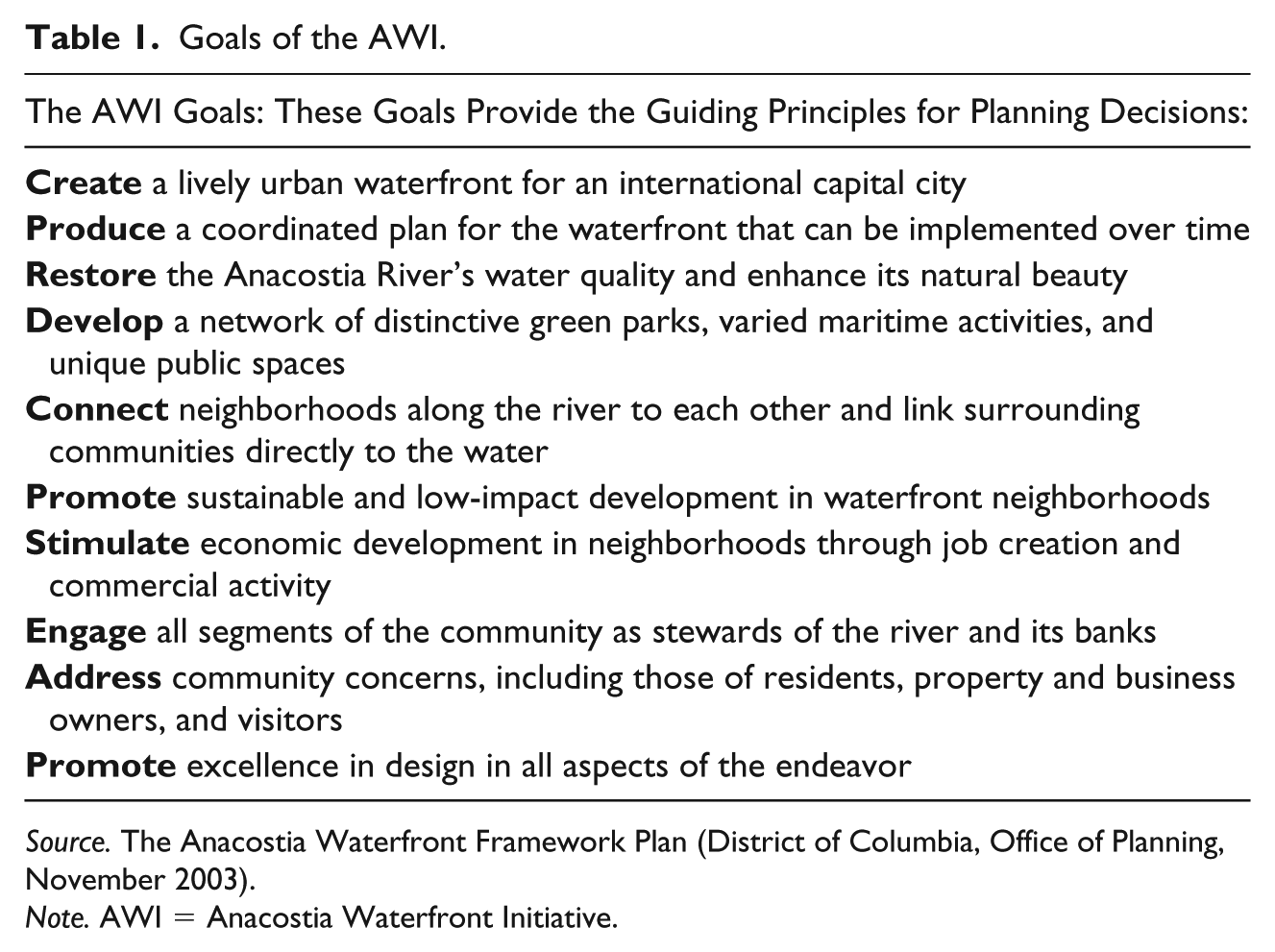
Source. The Anacostia Waterfront Framework Plan (District of Columbia, Office of Planning, November 2003).
Note. AWI = Anacostia Waterfront Initiative.
Essentially, with downtown D.C. almost built out, the Framework Plan pictures the neglected Anacostia waterfront as the future growth corridor of D.C. The riverfront is imagined as a source of economic opportunity, a catalyst of growth that will create jobs, stimulate business activity and enhance the tax base. The benefits would supposedly accrue to the surrounding neighborhoods, and, thus, mitigate the gaps between wealth and poverty on the two sides of the river. The plan specifically mentions that market-driven development on the western side of the river will generate resources that will make more investment possible on the eastern side, where appropriate conditions for economic development are lacking. In addition, with new cultural venues, museums, and monuments, the Anacostia would serve as a “great civic space and common ground” for a diversity of crowds (District of Columbia 2003, p. 9).
Between 2003 and today, numerous projects came about as part of the AWI. The majority of them were initiated by the Anacostia Waterfront Corporation before it was dissolved by Williams’ successor in 2007, but some are still works in progress at the time of writing. Some of the most notable projects are the Capitol Riverfront neighborhood (which contains the Yards Park; see Figure 1), the Nationals Park Stadium, The Wharf (a mixed-use development), and the new U.S. Department of Transportation headquarters. From an economic-development standpoint, the AWI was transformative in the manner expected: It helped to create a new growth area, attract investors, stimulate job growth, and enhance the tax base of the District. A recent report by the World Bank (Amirtahmasebi et al. 2016) states that the AWI, when complete, will have attracted an estimated $25 billion in private and public investment, and is projected to generate $1.5 billion in additional tax revenue for the District per year. As well, the total population of the AWI area has increased by 40% between 2000 and 2009, from 16,675 to 23,280 people (Amirtahmasebi et al. 2016). Overall, the World Bank considers the AWI one of the largest and most successful redevelopment plans in the United States to date (Amirtahmasebi et al. 2016).
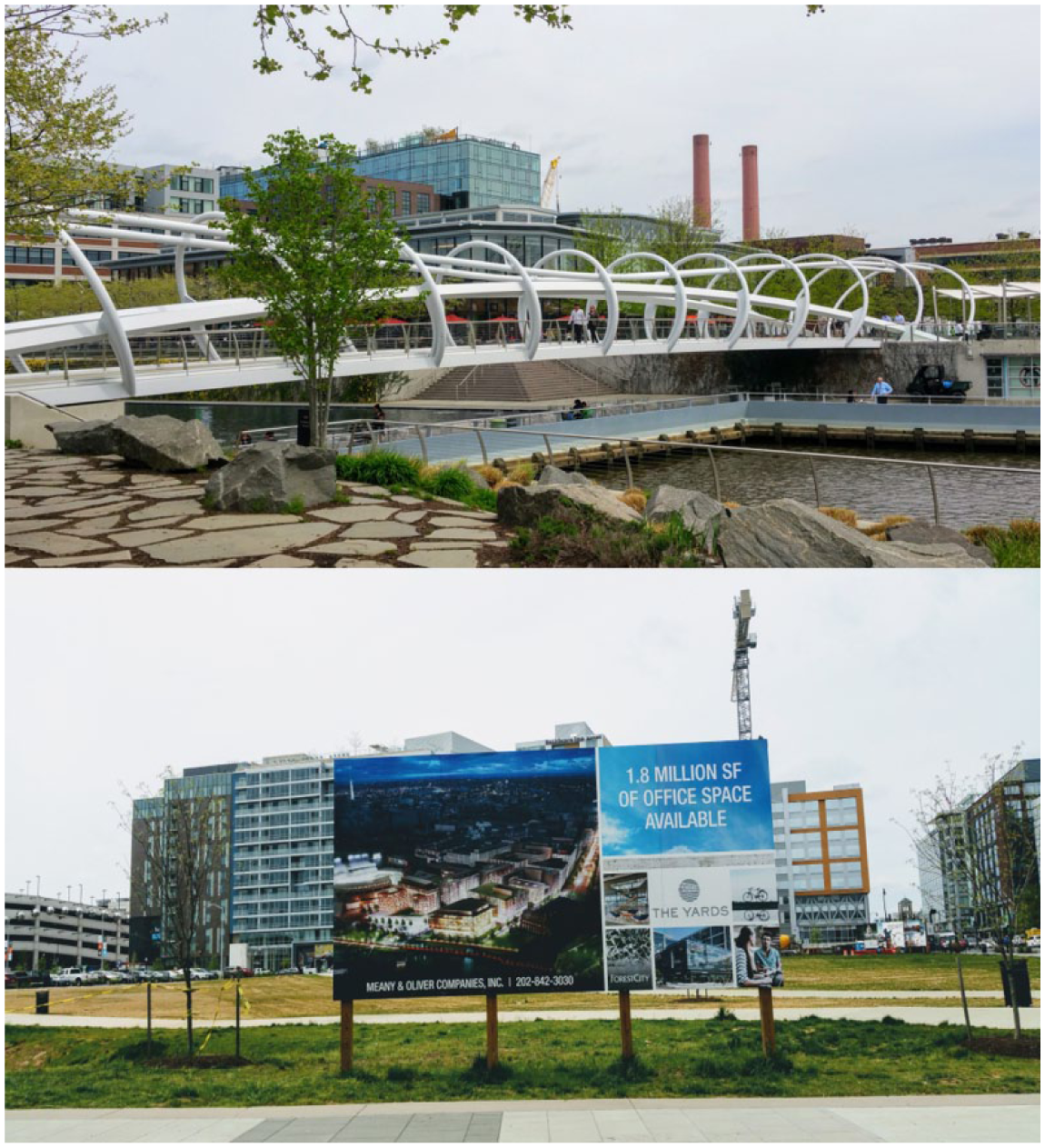
The Yards development: The Yards Park (upper photo) and new office space (below).
Social Justice Aspects of Development
Although social justice and equitable development are part of the rationale for launching the AWI, they are not clearly defined in public documents. The general idea that the latter convey is that economic development resulting from the AWI will benefit Washington’s disadvantaged communities. In other words, the initiative follows a “trickle-down” logic under which gains from the development will spread to neighboring areas. Still, many aspects of large-scale redevelopment can at least potentially affect urban justice. In this section, we touch upon three such aspects that our interviews in Washington, D.C., and the literature highlight as particularly relevant: accessibility, civic spaces, and housing and gentrification.
Accessibility and Public Space
The related themes of accessibility and public space have been central in studies of waterfront redevelopment. They pertain to the key rationales of many projects, that is, the desire to connect cities to the river, lake, or sea at which they are located and to revive underutilized areas as spaces of civic engagement. Ironically, while many barriers (e.g., fences, highways, railroads) have been removed from historically inaccessible waterfronts, new ones have been introduced in their stead (e.g., luxury housing, high-end shops, and tourist attractions). Accordingly, scholars have critically examined whether waterfront redevelopments have, indeed, resulted in accessible and inviting public spaces (Dodman 2008; Stevens and Dovey 2004).
Accessibility
At the time of drafting the Framework Plan, only two out of the 15 communities that line the Anacostia River had direct access to the waterfront. Other neighborhoods were cut off from the water by highways, fences, and contaminated land. Moreover, very few bridges allowed for crossing the river, even less so if crossing by foot or bicycle. As a result, each side of the river was “out of sight, out of mind” for the majority of people on the other side. The river itself had very little presence in people’s perceptions; aside from being a barrier, it played a limited role in the lives of residents. Our findings indicate that the troubled relationship between the city and the river has slowly been shifting for the better. The cleanup of the waterway and the outreach led by NGOs and the government are generating a more positive relationship and a greater embrace of the river by the community. The president of Anacostia Watershed Society, an environmental NGO, explained the shift: Most rivers don’t have this [negative perception as the Anacostia does]: it’s the “forgotten” river, “the river is dirty don’t go there,” “I only drive through there with a gun on my chair” kind of thing. Most rivers are embraced by the community a lot more. So we still have a way to go to overcome that, but every day it gets better. One of the things is just reconnecting people to the river . . .
The troubled relationship between the city and the river can be and is being reversed through policy change and community engagement. A number of nonprofit organizations, such as Living Classrooms, Earth Conservation Corps, and Anacostia Watershed Society, provide educational and environmental programs, some targeted at disadvantaged youths, to enhance the connections between local communities and the waterway. They organize boat tours, cleanup events, wetland restoration activities, hikes, and environmental education activities. These programs are partly or fully funded by the District and have a special role in making the Anacostia more visible to the nearby communities and in encouraging public stewardship of the river.
The Anacostia Riverwalk Trail was proposed in the Framework Plan and is currently being completed by the District Department of Transportation. The 28-mile trail runs on both sides of the river, along its entire length, and serves pedestrians and cyclists. It links and provides access to various attractions and points of interest such as Nationals Park, the National Arboretum, and Kenilworth Gardens. Neighborhoods such as Capitol Hill on the west side of the river, which were previously not perceived as waterfront neighborhoods, today enjoy the proximity to the waterfront and its new amenities.
The physical geography of the river and the fact that it flows through different neighborhoods mean that it is accessible, in theory, to a variety of communities. However, even with the above-mentioned improvements, getting to the Anacostia in some areas is still challenging, particularly for people who do not have a car or a bicycle. A lack of adequate public transportation and the presence of a highway around Anacostia Park are still significant deterrents to enjoying the waterfront.
Public spaces
Washington, D. C., is known for its museums and monuments. The Mall and the city’s grand avenues host millions of tourists each year who visit the historic and symbolic sites. Yet, during the diagnostic process of the AWI, city planners found that the river corridor lacked civic spaces that cater to the local population. They viewed new civic spaces, mostly in the form of public open spaces, as necessary components of a revitalized waterfront. Thus, the Framework Plan put much emphasis on the design of parks and open spaces not only on account of their environmental and health benefits, but also for their role in creating vibrant, diverse civic spaces. In total, more than $100 million has been invested to create public parks (Amirtahmasebi et al. 2016). The Yards Park (Figure 1), adjacent to the Navy Yard complex on the west side of the river, is one such park.
A senior planner from D.C.’s office of planning explained the importance of the Yards Park in the Framework Plan as a whole: One of our first investments was in this park because we wanted to make sure a) that this was about the river. . . . But two, we wanted to do something that was at the center of this racial division. This park has a whole central organization that was set up to just run the park, the BID [Business Improvement District]. The BID has essentially a dedicated program to welcome people from across the city to this park through special agreement with the [District]. There are concerts here and food festivals. Everyone is creating kind of a new civic sense to the city and a new sense of common ground, which in the District of Washington has been really missing. (Interview, September 2016)
Indeed, programming of the parks came up as a key element of the revitalization scheme for the river. The new parks in the area offer a variety of complementary programs such as music concerts, festivals, movie screenings, recreation, and culinary events. These activities—in addition to the well-taken-care-of surroundings, beautiful river views, and family-friendly amenities, such as water features—attract growing numbers of users: On weekends and special events, the parks are packed with people. The executive director of the Business Improvement District (BID) affirmed that the Yards Park provides a “sense of community and sense of place and opportunity for social interaction” and that the park “[attracts] a very diverse crowd . . . racially, very diverse crowds from an age standpoint, from an economic standpoint,” including families from the nearby Hope VI public housing project, residents of Wards 7 and 8, and the southwest (Interview, September 2016).
Public spaces and programming were also considered instrumental by a senior planner at The Wharf, a new development at the Southwest waterfront. Like the Capitol Riverfront neighborhood, The Wharf is a mixed-use project composed of housing, retail, and parks. When asked about the principles that are behind the project, the planner stressed that The Wharf will house a diverse population in terms of age and income, and that the programming will be, accordingly, diverse. Moreover, the planner said, the management of The Wharf sees the hospitality side as important: The staff who work there, such as security guards and gardeners, are seen as “ambassadors” of the project, whose responsibility is to make visitors feel welcome. “Our goal is that this will be a very welcoming place,” the planner said. “Some new developments . . . are very high end . . . so posh and almost cold. That is absolutely not what we want,” the planner added (interview, September 2016).
While developments such as The Wharf and Capitol Riverfront are often criticized in public and academic discourse for tailoring to a high-end clientele and fostering social exclusion, it is important still to consider the public benefits that may derive from them. Surely, the Yards Park is steps away from nice restaurants, expensive condos, and the Nationals Park Stadium, which are unaffordable to the city’s poorer residents. In a similar vein, The Wharf creates a shiny “world-class” façade in a formerly gritty, working-class area. But, at the same time, the Yards Park has transformed industrial, virtually inaccessible wasteland into a beautiful public park that serves a diversity of residents. The connections between the two sides of the river are strengthened, then, when residents of Wards 7 and 8, on the eastern bank of the river, cross to the other side to enjoy the new public facilities. So far, however, this movement is mostly unidirectional, from east to west, as the east side does not offer equivalent, topnotch, park facilities. The Anacostia Park, which is east of the river and is operated by the United States National Park Service, is one of the largest and most significant open spaces in the District, but it suffers from disinvestment and is severely underfunded. The picture is, therefore, still very mixed, at best, with remaining inequalities between the two banks of the river, on one hand, and improved access to public amenities, on the other hand.
Housing: The AWI as “green gentrification”?
Pearsall (2018) defines waterfront redevelopment as its own category of catalysts of environmental gentrification. While the AWI did not cause direct displacement of residents, because the area was not residential in use to start with, the investments on the west side turned public attention to the Anacostia area and indirectly affected land values east of the river as well. As the green gentrification literature shows, displacement can be caused in indirect ways, for instance, by development policies that increase the land value in areas with low homeownership (Anguelovski et al. 2018; Avni 2018a). And, indeed, the rate of homeownership east of the river is quite low compared with that on the west side (Bogle et al. 2016). However, to fully account for the green (or blue) gentrification of the Anacostia area, one must consider the housing situation east and west of the river, and, in particular, affordable housing.
Affordable housing is a critical factor in the ability of low-income residents to live in a city with high real estate prices such as Washington, D.C. The willingness and ability of government to ensure affordability is, therefore, a measure of its commitment to justice (Fainstein 2010). Whereas previous urban redevelopment schemes in the District of Columbia were marked by direct displacement caused by Urban Renewal programs, today, such schemes are mostly led by “public–private partnerships in a market-driven process” (Howell 2016, p. 305). One of the landmarks of the AWI in the area of housing was the redevelopment of the Arthur Capper/Carrollsburg public-housing project, known as the Capers, a 707-unit complex built in 1958 as part of the Urban Renewal of Washington’s Southwest neighborhood. In 2001, the District received a grant from the U.S. Department of Housing and Urban Development (HUD) HOPE VI program to redevelop the complex as a mixed-use housing project with a 1:1 replacement ratio of all public-housing units. As part of the plan, a mix of subsidized and market-rate units were to be built in addition to the replacement units by increasing the density of the site (Amirtahmasebi et al. 2016). While the Capers project has been touted as a successful and “innovative” example of the AWI’s efforts to reduce gentrification (Amirtahmasebi et al. 2016, p. 325), interviews and other sources have revealed that the success of the project is contested. The old complex was demolished back in 2004, yet at the time of writing, the new project is still incomplete, and information on the number and type of new units is vague. According to an online local press release, the former 707 very low-income units will, in fact, be replaced by 417 low-income units; the remaining subsidized units are designated for moderate-income households. Furthermore, some of the units will be relocated to a site that currently has contaminated soil, and “low-income” units will be available to families with an income as high as $51,360, while the average annual income for current residents is only $7,942 (Fletcher 2016, n.p.). A community organizer who works for an affordable housing nonprofit expressed the fear that the prolonged construction schedule and the loss of community ties during the redevelopment process jeopardizes the return of long-term residents to the project.Other affordable housing initiatives within the AWI mostly concern new developments, such as The Wharf and The Yards, which comply with District policies for affordable housing such as inclusionary zoning. This policy requires that 20 to 30 percent of new units, depending on the type of project, must be set aside for people who make between 50 and 80 percent of the Area Median Income (AMI). Given that the AMI in Washington is very high [it was $109,200 in 2015) (U.S. Department of Housing and Urban Development 2016], inclusionary zoning does not really help households with very low incomes. (Interview with a community organizer, September 2016)
In phase 1 of The Wharf, of 649 apartments, 20% are affordable units for households earning less than 30% and 60% of AMI, while another 10% are workforce units for households at 100% and 120% of AMI (Capital Community News 2017). Of these, only apartments at 30% of AMI, which represents an income of $32,000 for a household of four people, can be considered affordable to low-income people (Boive, 2017). More generally, 4,500 new affordable units for families and seniors have been built in the AWI area since 2004, out of a total of 18,000 units (District of Columbia 2018). Given the relative definition of affordability, some maintain that these units cater to middle-class residents rather than the poor (Interview with a community organizer based in Ward 8, April 2017), while others maintain that, given the large size of subsidies going to developer and the small size of units they rent at affordable rates, the benefits to the public are minimal (Laber 2017).
Bridging the Divide?
“Reuniting” Washington was one of the major rationales for the redevelopment of the Anacostia. Today, some 15 years after the publication of the Framework Plan, it still remains to be seen whether that goal had been achieved. Most interviewees claimed or acknowledged that positive strides have been made in that direction. And yet, the mission is far from being completed, because facts on the ground have changed in a very asymmetrical way. Up to now, most of the development has been concentrated on the west side of the river: Nationals Park, Yards Park, the Capitol Riverfront neighborhood, and other projects transformed this formerly industrial part of the river. The east bank of the river, by contrast, has changed little in terms of its physical landscape. Large parcels of land on that side of the river belong to the National Park Services and the U.S. Armed Forces, and, therefore, are subject to development constraints. However, even without major redevelopment projects, incremental gentrification has started to occur in the Historic Anacostia neighborhood east of the river.
According to a senior planner, the AWI has been a remarkable success in terms of transforming the image of Washington, which is nowadays perceived as a waterfront city. The AWI “has changed the cognitive map of the city” and transformed the waterfront area to a cherished civic space: People now go to the waterfront and enjoy it. The Capitol Riverfront neighborhood, he said, is a success “beyond our wildest imagination.” Importantly, however, according to the planner, this success has not yet traveled east of the river: From the sense of “Has it brought the city together, and do people feel that somehow the division has been healed?”, that’s a tougher one because you’re dealing with a very concentrated poverty east of the river that a riverfront alone can’t on its own change. I do think if you go to the Yards Park and you go to [other] places down there you do see a lot of diversity. You see people using the park with different racial and socio-economic [profiles] and I think it has opened up the waterfront to people but I don’t know if you could say really what east of the river people feel about the Anacostia riverfront . . . . They probably look across and see the shiny stadium and all the development so that, you know, is it still a divide? . . . I think if you were to say “Is the job done?” I would say absolutely not done. . . . the social equity piece east of the river—to continue [to] try to bring the city together—it takes a whole new generation of activities to do that. (Interview, September 2016)
For the senior planner, waterfront redevelopment needs decades to unfold and cannot, on its own, undo a long legacy of deprivation. A similar notion is articulated in the District’s recently released 15-year progress report of the AWI: “While the Anacostia River’s renaissance has realized notable strides on inclusion, there is a need to ensure the next generation of waterfront projects purposely address equity” (District of Columbia 2018, p. 11).
In summary, much work remains to be done to improve social justice. When Mayor Williams took office in 1998, the planning department had a vision of adding 100,000 new residents to the city. At the time, that idea seemed overly ambitious, even absurd. According to senior planners we interviewed, gentrification was not a concern: lack of growth was. Waterfront redevelopment was part of that growth strategy, as it could accommodate large numbers of new housing units without displacing people, leading to growth in an equitable way. A few years later, however, Washington, D.C., started booming, and gentrification became a key policy concern. Although the AWI did not directly lead to displacement, it did create mostly upscale neighborhoods with high land values on the west, while not delivering much housing, public facilities, or job opportunities east of the river. Nonetheless, the fact that the AWI spurred development mostly on the west side does not mean that conditions in neighborhoods east of the river have remained exactly the same. Affected by general trends in the District and by changes brought about by the AWI, housing prices in the Historic Anacostia neighborhood have been on the rise as middle-class families are moving to the area. Gentrification east of the river might bring the two sides of the city closer together at the expense of longtime residents, contrary to the intention expressed in the Framework Plan.
Environmental Justice: A Fishable and Swimmable River
As places where land and water or city and nature meet, waterfronts have also been studied from the perspectives of sustainability, ecology, political ecology, and environmental justice (Bunce and Desfor 2007; Hagerman 2007). Centuries of exploitation of the delicate ecosystem of the Anacostia River, including through tobacco farming and industrial activities, turned the natural corridor into a wasteland, littered with immense amounts of garbage and poisoned with toxic residue (Wennersten 2008). While the issue of development around the Anacostia may be controversial, there is no debate about the importance of the river as a natural resource that offers opportunities for recreation, education, and aesthetic enjoyment. The Framework Plan prioritizes the environment as a primary object of action. “A Clean and Active River” is the section that opens the plan. It identifies several issues that require intervention such as improving water quality, eliminating pollution, and restoring natural systems.
Remediation Efforts
In the last few decades, remarkable strides have been made in the environmental remediation of the river thanks to government funding and collaboration with local NGOs. Although much work remains to be done, the Anacostia River has improved significantly from an environmental standpoint. The river is no longer considered one of the nation’s most polluted, and there is a growing appreciation of the benefits that its ecosystem provides for all. One of the most significant elements of the AWI has been the $2.6 billion Long-Term Control Plan (LTCP), a megaproject of underground tunnels to capture and treat sewer overflows and reduce the number of overflow events that occur during storms. It is expected to prevent 98% of future pollution and to be fully operational by 2022 (Anacostia Watershed Society 2014). Moreover, in 2009, the District passed the Anacostia River Clean Up and Protection Act, the so-called “Bag Law,” which placed a five-cent fee on disposable plastic bags, one of the largest sources of trash found in the river. The act proved to be highly successful in reducing the number of bags used in the District, and environmental organizations have reported a significant reduction in the number of plastic bags observed in the river. In addition, four cents of the fee go to the Anacostia River Clean Up and Protection Fund.
It is important to mention that the restoration of the river began much earlier than the launch of the AWI. Environmental groups, such as the Anacostia Watershed Society (AWS), issued calls for environmental justice and for a “fishable and swimmable” Anacostia long before the government turned its attention to the river, and they have remained key partners in its revitalization to date. The founder of AWS began cleaning up the river with small groups of local volunteers. They also planted trees, restored the wetlands, raised public awareness, and developed educational activities. Later, they successfully sued the U.S. Navy for dumping toxic waste into the river in the Navy Yard area, a violation of the Clean Water Act (Interviews with AWS founder and head of the board of directors, September 2016). The AWI tapped into these local efforts and, with funding and help from the federal government, managed to upscale them into a comprehensive environmental remediation project.
Efforts to reduce pollution and restore the river have paid off in a significant and visible manner. A recent article in the Washington Post captures the transformation of the Anacostia riverfront. The writer wandered around the ballpark, convinced by past visits to the area over a decade ago that “no matter how well the overall project went, you could never get near the Anacostia without holding your nose.” To his surprise, he was wrong: “In reality, after hundreds of millions of dollars spent by D.C. Water on its clean rivers project, the walk by the Anacostia is pretty, panoramic, breezy and odorless. And,” he added, “it’s lovely at sundown” (Boswell 2016, n.p.).
Urban nature
Under a classic environmental justice approach, researchers stress the tendency for decision makers to locate toxic and polluting industries disproportionately in proximity to poor and minority neighborhoods (Anguelovski 2013; Wessells 2014). With high levels of pollution and contamination and low levels of investment near Washington’s poor minority wards, the Anacostia River is certainly a case in point (Aber et al. 2017). Yet, the Anacostia is also emblematic of the positive attributes of a riverfront environment, the beauty of landscapes, the presence of open spaces, and the opportunities for social interaction. Many areas along the river that were previously blocked off or difficult to access are now reachable to the public thanks to the Anacostia Riverwalk Trail (Figure 2). Nine miles of river provide multiple destinations; one can wander along its shores and experience the changing ecosystem.
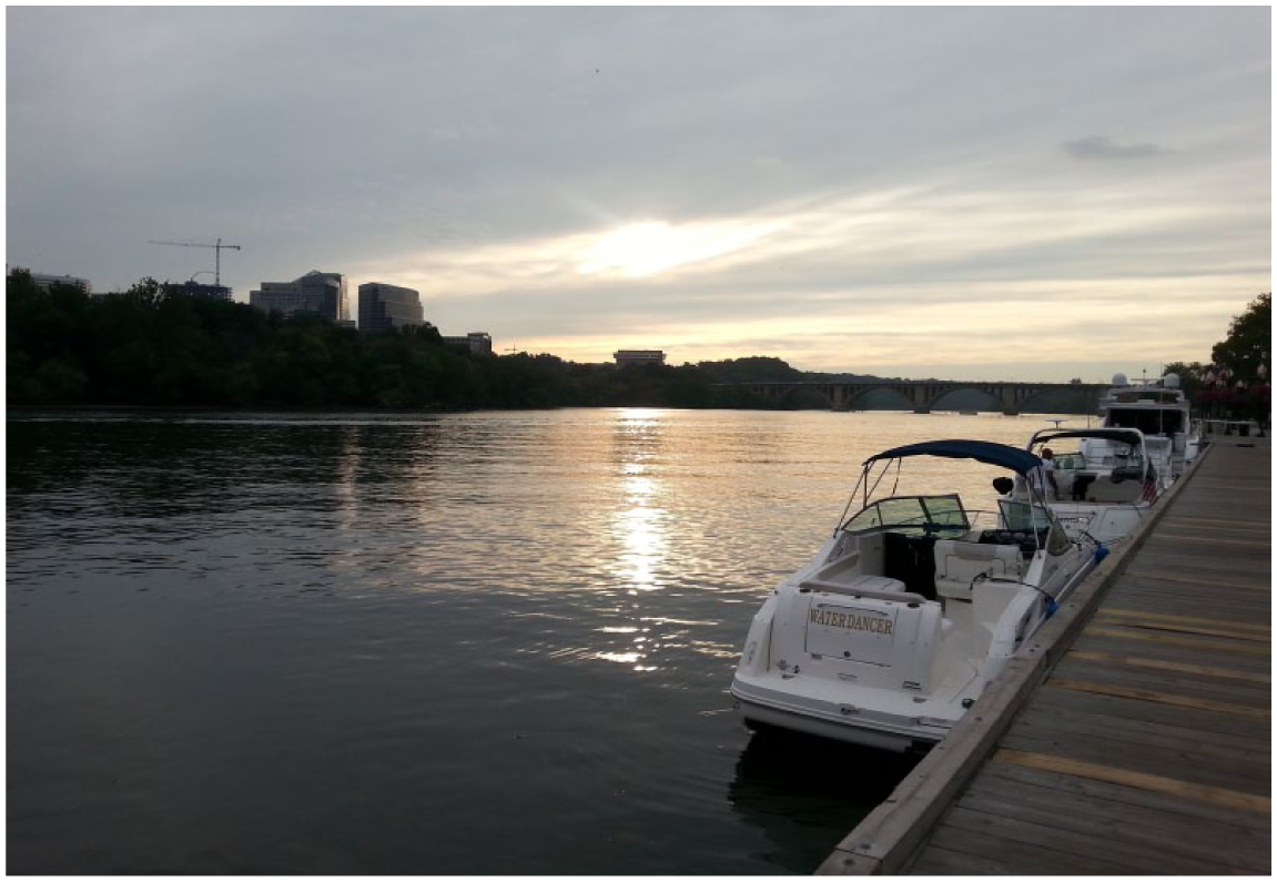
A peaceful scenery on the Anacostia Riverwalk Trail.
The riverfront and its banks allow for unmediated interaction with the natural elements and with flora and fauna; they also provide open views that are particularly precious in an intense urban environment. A senior employee at an environmental education nonprofit, born and raised east of the river, shared her own first positive interaction with the river, well before its restoration: I’m afraid of the water. But the first time I went on the river 30 years ago was the most spiritual experience that I have ever had. I was in a canoe and I was petrified, but once I was down the river and I knew I couldn’t go out, it was very healing for my spirit. As we saw the birds and the fish, you could just see the ecosystem and how everything connected. (Interview, September 2016)
Without getting onto the water in a canoe, one can appreciate the beauty and calm of the river. Anthropologist Brett Williams (2001, p. 424) found evidence that even in its worst state of pollution and neglect, the river was “almost inexplicably precious to people who live along its shores.” Some people went there to have picnics, gather with others, or spend time alone, relax and cool down in the summer heat, yet the number of people involved was small and the conditions were degraded. With the gradual cleanup of the river and growing conservation efforts, opportunities for such healing experiences as the environmental educator recounted have become more widely available. Her work and that of others have fostered environmental and social justice by spreading the river’s benefits while equalizing an unfairly distributed burden of costs. Still, the uneven intensity of redevelopment activity on both sides of the waterway has meant that much land on the east side remains in need of remediation. Remediation remains necessary for the riverbed itself: It is not known yet how it will be possible to remove or isolate the toxins buried in its bottom.
In sum, while significant discrepancies still remain between both sides of the river, at least from an environmental standpoint, the change is positive, overall. Pollution has been greatly reduced, the ecosystem is on a path to recovery, and communities are better able to reconnect with the river. At the same time, the environmental remediation of the river is a work in progress.
Discussion: From a “Forgotten River” to a Hub of Urban Development
In the last few decades, the waterfront has come back to the center of public attention. A space of production and transportation in the industrial era, the waterfront has been repurposed and rebranded as a center of consumption and recreation in the postindustrial era (Porfyriou and Sepe 2017). While waterfront redevelopment plans typically convey notions of improved quality of life, economic development, and increased accessibility, among other goals, very few have social and/or environmental justice as primary objectives. That is despite the fact that these plans reshape prominent areas of the city, affect numerous present and future residents, and require the expenditure of vast public resources. Although waterfront redevelopment projects open up the waterfront for new uses and improve access to the water, they often deliver mixed results with regard to social and environmental justice (Wessells 2014).
Are redeveloped waterfronts essentially “Trojan Horses of Gentrification” (Betsky 2017, n.p.)? Research on green gentrification shows that redevelopment of waterways and other green spaces, though originating in a desire to valorize underutilized land, can lead to marginalization and even displacement of longtime residents (Gould and Lewis 2017; Rigolon and Németh 2018). However, recent literature also points to the fact that waterfront redevelopments should not be seen as the outcomes of market forces alone (Brownill 2013). In theory, policies can be adopted to include affordable housing and public facilities in waterfront redevelopment plans. While economic considerations are often the drivers of such plans, there is no inherent contradiction between economic development and social benefits, and economic development may, in some cases, contribute to social justice if employment conditions are regulated and profits are captured for the benefit of city residents (Bornstein 2010; Fainstein 2010).
In practice, the AWI illustrates the challenges that exist to achieving both environmental and social justice and the potential trade-offs between these two aims. Environmental improvement has implications for social justice, as the residents who live in marginalized communities are finally able to enjoy the natural assets close to their homes, but must also contend with the rise in real estate values that follow from remediation. Such trade-offs between social and environmental objectives are not inevitable, but planners struggle to successfully achieve the two. To do so, they must integrate justice goals explicitly in their plans for large-scale redevelopments. They must also translate statements of intention into concrete policies and programs, with empirical indicators of success.
Our analysis of the AWI supports a nuanced reading of waterfront redevelopment, which responds to the imperatives of both private gain and public benefit. On one hand, in a district with a limited tax base, the AWI generated major tax revenues and enabled the city to invest in schools, housing, and amenities. According to District’s figures, it “has invested or budgeted over $US300 million in school modernizations, library renovations, and recreation centers in Anacostia waterfront neighborhoods through 2020” (District of Columbia 2018, p. 27). Some affordable housing has also been provided through inclusionary zoning and the HOPE VI program. Moreover, the Anacostia River is an important natural and public resource whose development responds to public-interest concerns such as city beautification and civic pride (Boland, Bronte, and Muir 2017). On the other hand, the AWI is viewed by some as planned green gentrification, with the effect, if not the goal, of transforming working-class, racial-minority neighborhoods into world-class living areas for wealthier residents—a trend that has been documented elsewhere in D.C. (see Hyra 2017). Approximately 15 years after the Framework Plan was first released, it is clear that economic growth has been a more important motivation than social justice, even though social and environmental justice have, indeed, been pursued as policy and planning goals. Evidently, the recent progress report that tracks the AWI since 2003 speaks of justice to a much greater extent than did the original plan, and its authors admit that more could be done to address issues of social and environmental justice (District of Columbia 2018).
In short, while the AWI was conceived in response to significant socioeconomic and racial gaps between populations east and west of the river, social justice goals were not prioritized in the implementation of the project. The AWI also highlights the problems associated with this approach, whereby economic growth is seen as paramount. The initiative has yielded important fiscal benefits to the District, but it is not clear to what extent and how these benefits actually served the low-income and marginalized communities east of the river. Restoring a river basin that has historically been overlooked and tackling its environmental contamination are worthy undertakings, yet justice cannot be achieved only by means of environmental remediation, economic growth, and/or improved facilities. Even to this day, the Anacostia River still forms a division between the prosperous western and poor eastern parts of Washington, D.C., albeit a river with cleaner water and greatly improved access to its shores.
Conclusion
Waterfronts are once again desired areas of the city, charged with economic, political, and social value, and they are the object of major redevelopment schemes in varied geographic settings. The environmental aspect of their redevelopment is increasingly important, due in part to the growing risks of climate change and sea-level rise (Hein 2016). However, as is made evident in this study and others, success in environmental improvement brings new challenges. These challenges extend beyond functional and/or administrative ones, which were typical of the first wave of waterfront redevelopment. They pertain, in particular, to the social implications of urban transformation. The examples provided in the Introduction spoke to the potential of waterfronts to contribute to social justice and well-being. Still, as we showed in our case study, opening up the waterfront to the public and investing in environmental remediation and in public spaces and facilities may counteract benefits if the revitalized landscapes become new areas of exclusion.
Urban waterfronts are key sites of conflict over economic, cultural, and social change. The conflict is not only between different constituencies but also between different policies and even between different values. The experience of the AWI (and other such projects) shows that even the best-intentioned officials and planners, who act to remedy historical injustice in the distribution of opportunities and amenities, encounter great difficulty in prioritizing social and environmental justice over economic development in long-term revitalization plans. It also shows that they struggle to find a balance between these two aspects of justice, having to contend with the external effects of environmental improvement on social and economic opportunity. Thanks to the initiative, a once-neglected and heavily polluted river has been turned into an axis of tax-generating real estate development and an accessible recreational corridor. But the removal of an old barrier between well-to-do and marginalized communities has opened the latter to gentrification and forced ongoing trade-offs between different public goods.
Footnotes
Declaration of Conflicting Interests
The author(s) declared no potential conflicts of interest with respect to the research, authorship, and/or publication of this article.
Funding
The author(s) received no financial support for the research, authorship, and/or publication of this article.
