
Abstract
A common rule of thumb for signalization in a city is one traffic signal for every 1,000 residents. When a city is depopulating, does this ratio apply when determining how many signals can be removed? The City of Detroit has lost 61% of its population since its peak. If signals were installed to serve the peak population, applying this rule of thumb, 61% of the signal inventory should be able to be removed. An operational analysis was performed on a random sample of the signal inventory of the City. Based on this sample, it was determined that 30% of the signal inventory could be removed and replaced with either two-way or all-way stop control, while still maintaining adequate levels-of-service for all approaches, resulting in a savings of US$460,000 to US$3,700,000 annually in operating costs. Other cities with declining populations should conduct similar analyses to reveal the extent of potential savings.
Introduction
In 1950, Detroit had a population of 1,849,568; in 2010, Detroit had a population of 713,777. In those 60 years, Detroit lost more than 1.1 million residents, or 61% of its population (U.S. Census, 2010). With this sizable reduction in population has come a reduction in the city tax base and operating revenue. Because of Detroit’s tax revenue contraction, it has found itself unable to provide even basic services effectively. Because the city is in a dire financial condition, being the largest city in the country to declare bankruptcy, it is imperative for the city to find ways to save money. One of those ways might be to remove unnecessary traffic signals, thereby reducing the amount of money the city needs to operate its traffic control system.
Objective
The objective of this study was to determine what percentage of traffic signals Detroit could remove with no harm to traffic flow or safety. The city had earlier conducted a traffic study of more than 200 signals in the downtown and Midtown areas and had begun the signal removal process for many of them (Beshouri, 2013). This effort extends that previous one to include the rest of the city. Satisfying this objective for Detroit should also show what other cities with declining populations could achieve by removing signals.
Previous Literature
Prior to the commencement of this study, the City of Detroit commissioned a study in the Midtown and downtown areas of the city. This combined area is bounded approximately by East Grand Boulevard on the north, the Chrysler Freeway on the east, the Detroit River on the south, and the Lodge Freeway on the west, and is shown with cross-hatch in Figure 1. It encompasses approximately 4.5 square miles, which constitutes approximately 3% of the area of the City of Detroit, and contains roughly 15% of all of the signals within the Detroit city limits. As a result of this study, the City of Detroit identified 20 signals for removal (Beshouri, 2013).
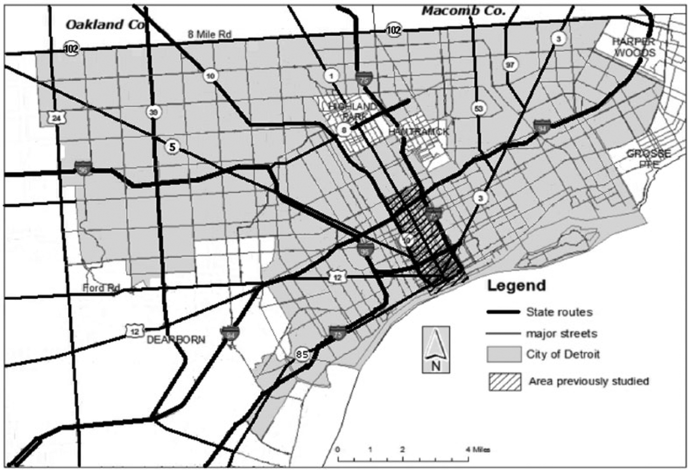
Map of the City of Detroit showing the area previously studied.
While the majority of the available research and literature about traffic signals relates to the installation and optimization of signals, there exist several important works on the removal of signals. The seminal works relating to traffic signal removal are Criteria for Removing Traffic Signals (Kay, Neudorff, & Wagner, 1980) and, its companion piece, the User Guide for Removal of Not Needed Traffic Signals (U.S. Department of Transportation, 1980). These documents established a procedure for evaluating and prioritizing signal removal based on four key factors: safety, fuel consumption, traffic flow, and cost. Some of the consequences of unwarranted signals, such as operation and maintenance costs, which range from US$1,000 to US$8,000 per signal per year (Kansas Department of Transportation, 2014; U.S. Department of Transportation, 2009; Washington State Department of Transportation, 2014), fall within one category; some, such as disrespect for the traffic control device, fall in several. Subsequent publications have neither added to nor superseded these factors; rather, they have elaborated on them. Gerth’s Handbook of Traffic Engineering Practices for Small Cities (Gerth, 1982) provided a method for monetizing delay, specifically, the cost of speed change versus maintaining a constant speed. Gerth also detailed several other subfactors of the traffic flow factor, such as disregard of the signal and diversion of traffic to other streets. Orcutt and Sullivan (1991) added an additional traffic flow subfactor, the freedom of the driver to control his or her own progress.
Because of the importance of crashes to policymakers and the general public, much of the literature that references signal removal pertains to crashes and safety issues. Persaud, Hauer, Retting, Vallurupalli, and Mucsi (1997) analyzed 199 one-way intersections in Philadelphia, where signals were removed, and found a 24% reduction in crashes. In a report on crashes due to red light running, the Insurance Institute for Highway Safety (IIHS) alludes to the Persaud et al. study with a suggestion that removal of unwarranted signals is one strategy for reducing crashes at signalized intersections (Retting, Chapline, & Williams, 2000). Subsequently, both the Institute of Transportation Engineers (ITE; 2003) and the National Cooperative Highway Research Program (NCHRP; Antonucci, Hardy, Slack, Pfeffer, & Nueman, 2004) followed the lead of the IIHS and incorporated traffic signal removal in their strategies for reducing collisions at signalized intersections. The NCHRP report not only mentions the safety benefit of signal removal but also the traffic flow subfactors enumerated by Gerth, although it does not mention the subsequent subfactor added by Orcutt and Sullivan. The Crash Modification Factors (CMFs) Clearinghouse refers to the Persaud et al. study as a source of CMFs for signal removal (U.S. Department of Transportation, 2014).
Several studies have recommended roundabouts as an alternative to signalized intersections. Wallwock (1997) found that roundabouts improve safety by reducing crashes and operating speeds through the intersection, increase intersection capacity, and are cheaper to operate, as there is no longer a need to maintain and operate a signal. Turner (2004) concluded that the placement of roundabouts in lieu of signals produces lower travel times and delay. Retting (2006) and Nambisan and Parimi (2007) used the reduction in crashes and improvement in safety to recommend replacing signals with roundabouts. Voigt and McCombs (2010) suggest replacing signals with roundabouts for sustainability reasons.
Method and Results
The methodology used to complete this study consisted of five sequential tasks: comprehensive inventory of signal locations, classification of signal locations, assignment of traffic counts, random sampling, and level-of-service analysis of randomly sampled locations.
Task 1: Inventory
The first task involved completing a comprehensive inventory of all signal locations in the city. Due to budgetary and staff cuts over the years as the city has shrunk, the city does not have this information readily available. Because of this dearth of information, the researchers decided to perform this task using a combination of Google Earth and on-the-field spot checks to verify the accuracy of the Google data. The researchers encoded signalized intersection location data in a spreadsheet, which allowed for the easy addition of data collected in the subsequent tasks.
The researchers established the following guidelines to determine which signalized intersections to include in the inventory:
Signals on perimeter streets, that is, streets that form the corporate boundary of the City of Detroit, were to be included.
Signals at U-turn crossovers for median U-turn intersections were treated as independent intersections.
Offset intersections were considered independent intersections if they were striped as such.
Signals for each direction of a freeway frontage road system were considered to be independent of each other. Thus, for a typical interchange, the signals on either side of the mainline were unique and independent, as one could exist without the other. At a signalized three-level interchange, the researchers treated the four signals on the middle level as independent from each other.
As of July 2013, the inventory from Task 1 showed that there were 1,510 traffic signals in Detroit, or one signal for every 470 residents. As mentioned, one “rule-of-thumb” estimate for ideal signalization used among many traffic practitioners is one signal per 1,000 residents. Based on this “rule of thumb,” Detroit should have 714 traffic signals, 47% of its current inventory. This raised the question of whether it is feasible for Detroit to remove up to 800 signals from its current inventory.
Task 2: Classify Inventoried Signals
Theoretically, every traffic signal that doesn’t meet prescribed performance standards can be removed. However, there are certain signals that cannot be removed regardless of performance and therefore did not need to be studied. Likewise, there are signals that have already been studied and also did not need to be studied. To separate the signals to be excluded from further study, and identify why they have been excluded, it was necessary to establish a classification system. The 1,510 signal locations were classified into the following categories:
Thirty-one signals, or 2.1% of the total signals in the City of Detroit, were determined to be special purpose signals. Special purpose signals are those installed for a special or specific purpose, such as a hospital, arena, plant, or school that was readily observable from aerial photos or a field visit. They were excluded from consideration for removal, as these signals typically are removed or deactivated when the use for which they were installed is no longer in existence. Therefore, special purpose signals were not included in the eligible removal population.
Two hundred thirty-two signal locations, or 15.4%, were major intersection signals, that is, signals at intersections of two regional arterials or interchanges of a regional arterial and a freeway. A regional arterial is one that directly connects the central city with other parts of the region that could be used as a substitute for the freeway system, or that would be used by non-residents for travel through the region. The section line roads at 1-mile intervals, both east–west and north–south, were considered regional arterials, as well as the “diagonals” that radiate out from the central city to the surrounding suburbs. In addition, connectors from major special generators, such as airports, were considered regional arterials, as they are utilized by people from throughout the region. In Detroit, half-section roads do not have uninterrupted lengths long enough to function as a regional arterial and thus were not considered to be such. Major intersection signals were also removed from further study, as these are locations where the traffic volumes on all approaches are likely high enough to warrant signals and signals could not easily be removed without major intersection reconstruction and upgrades (such as roundabouts, alternative intersection designs, or grade separation). Like special purpose signals, major intersection signals were not included in the eligible removal population.
Two hundred twenty-six signals, or 15%, were previously evaluated signals. Previously evaluated signals were those examined in the earlier study of downtown and Midtown, and were removed from further consideration. All signals in a geographic area bounded by East Grand Boulevard, the Chrysler Freeway, the Detroit River, and the John C. Lodge Freeway had been previously studied.
Approximately one-third of the signals inventoried fell into one of these three categories and were not considered for analysis. The remaining 1,021 signal locations, or 67.6%, were subjected to further analysis.
Task 3: Random Sampling
The researchers did not have the resources to examine in detail each of the 1,021 selected signal locations, so they chose a random sample of 100 for analysis.
Task 4: Traffic Counts
Average annual daily traffic (AADT) estimates for each leg of each selected intersection were collected from the database maintained by the Southeast Michigan Council of Governments (SEMCOG). The SEMCOG database is large, and estimates were available for most intersection legs of interest. Typically, the estimates for all legs of a particular intersection were from the same year, although estimates for different intersections along the same corridor could be from different years, with all estimates from within the past decade. Where no AADT estimate was available, the AADT was assumed to be 1,000 vehicles per day (vpd), as almost all of these locations were short local streets.
Task 5: Level-of-Service Analysis
The final task was performing a level-of-service analysis to see how well each sampled intersection would function in the peak hour if the signal was removed. The researchers performed this task using the 2010 version of the Highway Capacity Software (HCS). At locations where the AADT on the lower volume approach for one street was higher than the AADT on the higher volume approach of the cross-street (i.e., the streets can be clearly labeled as “major” and “minor” streets), the intersection was analyzed using the HCS two-way stop control module. Where the volumes on the two streets were approximately equal or where the researcher could not easily ascertained which street was the major street and which was the minor street, the HCS all-way stop control module was used. An analysis time of 1 hr was used throughout. Other assumptions made during the analysis included the following:
Peak hour volumes were 10% of the AADT,
Where the AADT was bidirectional, the directional split was assumed to be 50/50,
On multilane approaches, volumes were evenly distributed among the lanes.
To conclude that a currently signalized intersection could be operated as stop-sign controlled, all movements at the intersection must be able to operate at Level-Of-Service (LOS) C or better with stop-sign control. Given the broad assumptions used during the analysis, and the tough criteria for LOS C in the unsignalized intersection chapters of the Highway Capacity Manual (HCM), a cut-off of LOS C gives enough latitude so that actual signal removal would likely not create significant delays or queuing.
The HCS unsignalized intersection analysis of the 100 randomly selected signalized intersections yielded the following results:
Twenty-one could be replaced with a two-way stop with LOS C or better
Twenty-four could be replaced with an all-way stop with LOS C or better
Fifty-five could not be replaced with STOP control and achieve LOS C or better
These results are graphically represented in Figure 2.
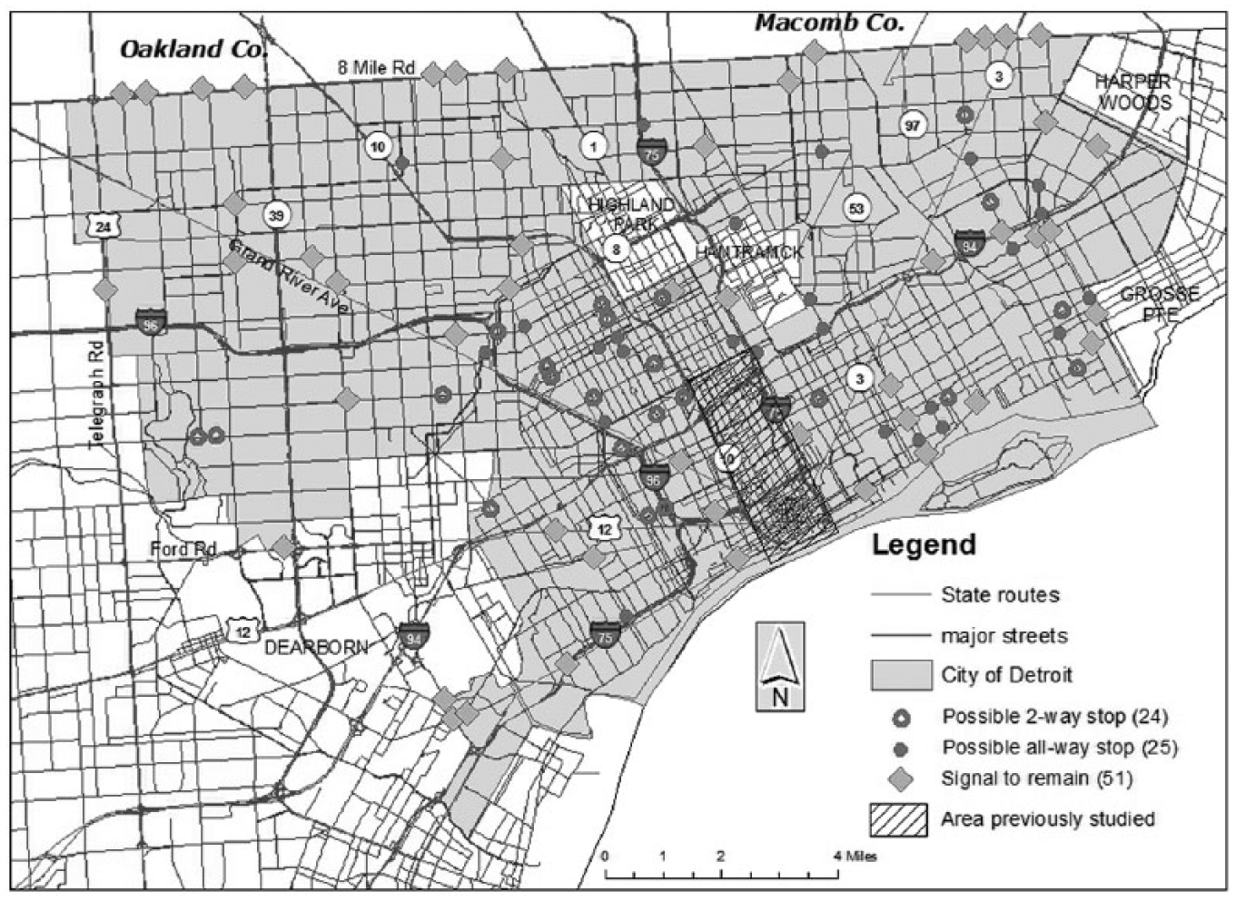
Map of the City of Detroit showing the results of the analysis.
Extrapolating the sample percentages to the entire 1,021 signals considered for possible removal shows about 460 signals that could be removed and replaced with either two-way or all-way stops. These 460 signals represent approximately 30% of the entire City of Detroit inventory of 1,510 signals. This percentage is about half of what would be expected, namely 61%, based on the population-based rule of thumb provided earlier.
Example
One of the intersections that can be replaced with a two-way stop is the intersection of Charlevoix and Lakeview in eastern Detroit. Charlevoix Street is the westbound half of a 1-mile-long one-way couplet and accommodates three lanes of traffic; Lakeview is a local neighborhood street. Because of its location in a depopulated area, all corners of the intersection are vacant lots, with the structures having been demolished and removed. During a site visit on a typical weekday, this fully functioning signalized intersection was completely devoid of activity, save the operation of the signal itself. In the 3-min the observer watched the intersection, the signal went through three cycle changes and serviced one vehicle and no pedestrians on all approaches combined. Estimated AADT for the three-lane Charlevoix was 1,500 vpd, and for Lakeview, the AADT was assumed generously to be 1,000 vpd.
Conclusion
Based on random sampling and HCS analysis, approximately 30% of the existing signal inventory in Detroit, 460 signals, could be considered for removal. Figure 2 shows the locations of the signals studied and the ones that likely could be removed. This represents approximately one-half of the total 61% population drop of the city. This result did not match the expectation of the researchers that the percentage of signals that should be considered for removal would be the same as the percentage population drop. Regardless, removing 460 signals from the inventory could save the operator in the range of US$460,000 to US$3,680,000 annually in operating costs based on the estimates of US$1,000 to US$8,000 per signal per year as previously noted. At those locations, traffic is likely to operate better with fewer delays, especially in the off-peak hours. In addition, there would likely be collision savings based on the results from the literature previously discussed. Because many of these locations are like the Charlevoix–Lakeview location stated in the example and are devoid of activity, pedestrians will not suffer, as the lack of pedestrians and vehicles means that potential pedestrian–vehicle conflicts are rare. While monitoring the Charlevoix–Lakeview intersection, the researchers observed that vehicles obeyed the signals, even though there was not any traffic on the cross-street; thus, it is reasonable to assume that motorists would observe any stop-signs installed at this location as well. Because many other intersections observed for this study were as deserted as Charlevoix–Lakeview, the assumption for the latter intersection applies to the others as well.
A plausible explanation for the lack of correlation between the number of signals that should be considered for removal and the population drop is that many parts of Detroit serve “pass-through” traffic, where neither the origins nor the destinations of trips are located in the city. Due to the high “pass-through” volumes on the major arterials, there are numerous signals that have to be maintained to provide gaps for pedestrians and vehicles that otherwise might not be needed. As Detroit has depopulated, traffic on its arterials has changed from mostly local traffic, traffic with either an origin or a destination in the Detroit neighborhoods they pass-through, to mostly through traffic, traffic with neither an origin nor a destination in the surrounding neighborhoods. Much of the traffic on the Detroit arterials is the traffic going to and from the Detroit central business district (CBD) to the suburbs; this traffic is merely passing through the neighborhoods. This phenomenon has created a situation with signalized intersections with a heavy volume on the arterial, due to through traffic, and light volume on the cross-street. Even though many of these intersections do not meet signal warrants, removal of the signals, while improving the level-of-service on the arterial, would seriously degrade the level-of-service on the cross-street, and thus should not be considered for removal. In other words, the City of Detroit, to provide acceptable levels-of-service to its residents, must maintain signals that would otherwise not be needed because of the use of city arterials by non-residents. In effect, a poor city is subsidizing the travel of residents of wealthier ones.
At those locations where some traffic control with more capacity than a stop control must be maintained, there are other intersection designs that could be evaluated. At intersections like Charlevoix–Lakeview where all four quadrants of the intersection are devoid of structures, a roundabout is a viable option, as open land is available. Roundabouts could also be used on multilane bidirectional streets where the intersections are large. For smaller intersections, where open land is not available, a mini-roundabout that can fit within the existing rights-of-way is a cost-effective alternative that would likely return its investment within a few years. For larger arterials that either have or could support a raised median, unsignalized treatments that prevent through traffic and left turns from the minor street, such as the restricted Crossing U-turn (RCUT; U.S. Department of Transportation, 2010), which is also known as a superstreet or a J-turn or the indirect left and crossing (ILAC), which consists of a median across the minor street with downstream U-turns to provide for left turns and the minor street through movements, should be evaluated as replacements for a signal.
The researchers are concerned that the analysis results might be affected by the limitation of the evaluation software with respect to approaches with more than two lanes. It is entirely possible that an approach that has more than two lanes provides adequate gaps for cross-street traffic, but as a two lane approach it will not. Thus, there may be some intersections where the cross-street level of service is actually adequate among those that were deemed to be inadequate. This limitation led to more conservative results for intersections with approaches of more than two lanes; in other words, it is possible that the researchers slightly underestimated the number of signals that could be removed without negative impacts.
Recommendations
Based on these results, the City of Detroit and other cities with declining populations should conduct a thorough evaluation of their current signal inventories, and remove those where stop control will provide adequate levels of service for all movements, and where there are no apparent safety or community concerns. Doing so could save Detroit US$460,000 to US$3,700,000 annually while reducing travel times and collisions, and could do the same elsewhere. The researchers recommend that signals at the intersection of a local street and a collector street be analyzed first, followed by signals at the intersection of two collectors, signals at the intersection of a local street and an arterial, and finally signals at the intersection of a collector and an arterial. Because of significant drops in traffic volumes due to depopulation, arterial–arterial signalized intersections, where both arterials are one-way or where one of the arterials has only one lane on an approach, should also be evaluated.
Detroit’s thoroughfare plan should be reevaluated, and streets reclassified to reflect the depopulation and actual operation, and the same should be done in other cities with declining populations. While field verifying some of the inventory locations, the researchers observed very little traffic at some arterial–arterial locations, suggesting that the classifications are outdated and some streets could be downgraded to sub-arterial status. By reclassifying arterials as collectors, several intersections classified as major intersection signals early in the study would no longer be in that protected classification and would become eligible for removal.
Detroit and other depopulating cities should evaluate all special permit signals. Many of these signals were installed for schools and other facilities that have either been repurposed or abandoned. In addition, some of these signals are in close proximity to other signals creating an often unnecessary redundancy that can be alleviated through signal consolidation.
Detroit has many underutilized signalized one-way couplets, such as Charlevoix, and likely other cities with declining populations do too. The cities should analyze the viability and necessity of these couplets and convert those that are not needed back to bidirectional operation. If one-way couplets are converted to bidirectional flow, then one of the pair should be designated as the thoroughfare and the signals should be removed from the other.
At locations where removal of the signals would seriously degrade the level of service on the cross-street due to high volumes on the arterial (e.g., those resulting from the “pass-through” phenomenon), consideration should be given to reconfiguration of the intersection to allow the removal of signals as discussed above. At other signalized intersections, it is possible a change as simple and cost-effective as restriping could eliminate the need for a signal.
Future Research
The researchers plan to conduct research focusing on the use of unsignalized alternative intersection designs to replace traditional signalized intersections. As part of this future research, alternative designs will be evaluated at three levels: intersection, corridor, and network. There are many interesting questions regarding those alternative designs. What designs will work for a particular intersection with respect to traffic operations and level of service? How will those designs affect operations in a corridor? Can different intersection designs be used in the same corridor, or does a particular corridor need to have a particular alternative intersection design? Will the use of alternative intersection designs at a location or in a particular corridor affect the performance of other intersections or corridors in the network, either positively or negatively? Indeed, in a city with a declining population, right-sizing the infrastructure raises many interesting research and implementation questions.
Footnotes
Declaration of Conflicting Interests
The author(s) declared no potential conflicts of interest with respect to the research, authorship, and/or publication of this article.
Funding
The author(s) received no financial support for the research, authorship, and/or publication of this article.