
Abstract
The article engages with theory about the processes of spatialization of fear in contemporary Western urban space (fortification, privatization, exclusion/seclusion, fragmentation, polarization) and their relation to fear of crime and violence. A threefold taxonomy is outlined (Enclosure, Post-Public Space, Barrier), and “spaces of fear” in the city of Palermo are mapped with the aim of exploring the cumulative large-scale effects of the spatialization of fear on a concrete urban territory. Building on empirical evidence, the author suggests that mainstream theories be reframed as part of a less hegemonic and more discursive approach and that theories mainly based on the analyses of global cities be deprovincialized. The author argues for the deconstruction of the concept of “spaces of fear” in favor of the more discursive concept of “fearscapes” to describe the growing landscapes of fear in contemporary Western cities.
Setting the Frame: The Spatialization of Urban Fear
Some years ago, Zygmunt Bauman (2005) observed that contemporary Western societies are the safest and yet the most fearful they have ever been. During the past few decades, this paradox has had spatial consequences in contemporary (Western) cities, as evident in scholarly debates about a wide range of processes: residential auto-seclusion, forced socio-spatial exclusion, fortification and privatization of public space(s), exclusionary urban renewal, fragmentation of urban territories, and so forth. Urban and geographical studies have been exploring several key concepts: Mike Davis’s (1998, 2006) “ecologies of fear,” the geopolitics of military urbanism (Graham, 2010); “splintering urbanism” (Graham & Marvin, 2001); discourses on terrorism and risk and their effects on urban production (Barnard-Wills, Moor, & McKim, 2012); the “end of public space” as the result of privatization (Sorkin, 1992); and research on “divided cities” (for a review, see Allegra, Casaglia, & Rokem, 2012). Can we really use the expression “spaces of fear” to summarize this range of processes? The core aim of this article is the deconstruction of the concept of “spaces of fear,” to be replaced with that of “landscapes of fear”or “fearscapes”—as debated in concluding remarks. Throughout the article, I will provisionally use the term {spaces of fear}.
Urban fear, together with its relationships to urban planning and production, is a complex and multilayered world, comprising several dimensions, such as the psychological, sociological, cultural, and politico-economic (Abu-Orf, 2013; Epstein, 1998; Sandercock, 2002). As such, as far as the production of fear of violence and crime in the urban realm is concerned, one cannot expect simple relationships between a “cause” (the volumes of violent acts and crimes) and an “effect” (fear). While one would expect some correlation between these two dimensions, we must remember Bauman’s findings: All across the Western world violent crime rates have being dropping dramatically since the early 1990s, at the same time as fear of crime has been growing to the highest levels ever recorded (International Centre for the Prevention of Crime, 2012; van Dijk, van Kesteren, & Smit, 2007).
Abu-Orf (2013) has offered a sophisticated theory for the paradoxes of fear embedded in urban planning in contexts of violent conflict and war. That said, as far as research on “ordinary” urban contexts (see Robinson, 2011) is concerned, mainstream urban studies have been treating fear as the direct consequence of crime—and thus urban security as a social demand—without questioning their mutual relationships (see Bannister & Fyfe, 2001; Cozens, 2011). In recent years, some of the layers of the urban fear paradox have been explored. In the new critical urban theories (Brenner, 2009; Marcuse, 2010), contemporary urban production is taken as being the result of hegemonic capitalist relations, while other scholars have built on Foucault’s (1975) “disciplines” to question the “dark side” of planning as a technopolitical means for controlling urban space (Pløger, 2008; Yiftachel, 2009). From these perspectives, spaces of fear are understood as being the result of hegemonic production, the built environment as a product of uneven power relations.
This article provides two steps toward more nuanced theories for the understanding of urban spaces of fear. First, Roitman, Webster, and Landman (2010) highlight how the literature on gated communities (GCs) has given limited attention to the way such developments transform urban fabrics by “segmenting the physical city [. . . .] and creating physical and emblematic barriers” (p. 9). This can be said of the studies available on the spatialization of urban fear in general. The article thus presents a taxonomy that stresses the cumulative impact of spaces of fear on urban fabrics (see the section “{Spaces of Fear}: A Taxonomy”) and a map of spaces of fear in an actual urban territory—that of Palermo, Italy (section “Mapping {Spaces of Fear}: Palermo”).
Second, building on empirical analysis and focusing both on hegemonic discourses on the (capitalist) production of space and on the discursive relations that frame spaces of fear at the local level, a slight reframing of mainstream theories (see the section “Debate: Replications and Deviations From the Theory”) together with a different conceptual approach (see the section “From {Spaces of Fear} to ‘Fearscapes’”) are suggested. This is consistent with recent calls for a deprovincialization of urban theories (Amin & Graham, 1997; Meagher, 2010; Robinson, 2011), insofar as mainstream debates risk making generalizations based on the exceptional cases of global cities. For this reason, this article presents the case of an ordinary city, Palermo, in a region, Southern Europe, at the “borderlands” of urban theories (Baptista, 2013; see the section “The Context”).
{Spaces of Fear}: A Taxonomy
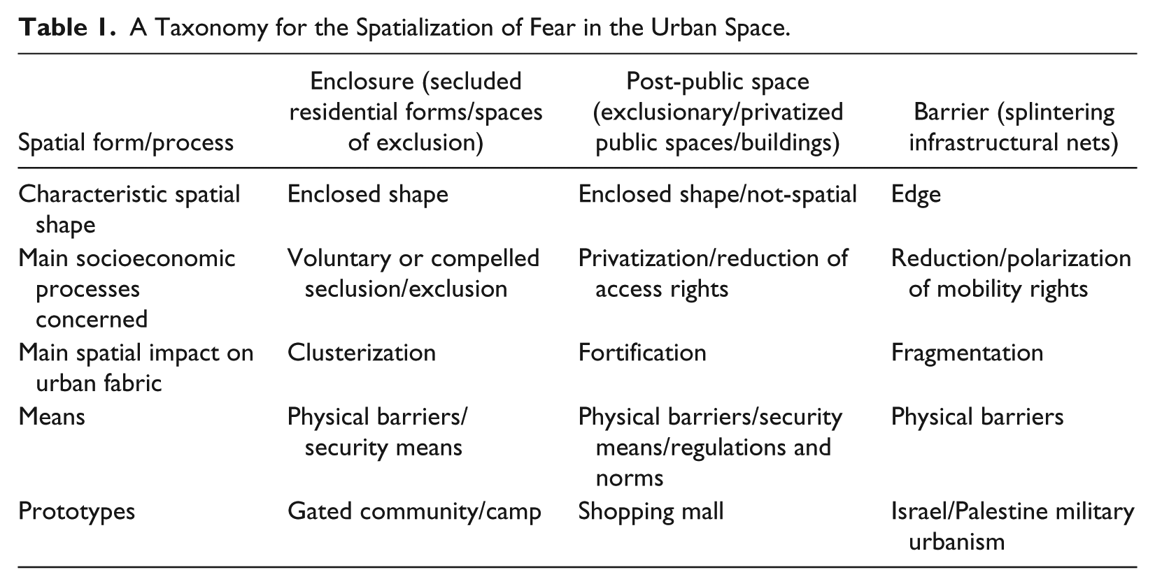
In this section, a literature review is organized through a threefold taxonomy that focuses on the cumulative spatial effects of spaces of fear. The aim is to frame a conceptual methodology for the practice of mapping (see the section “Mapping {Spaces of Fear}: Palermo”). “Enclosure” refers to spaces of exclusion/seclusion, “Post-Public Space” to the privatization and fortification of public space(s) and buildings, and “Barrier” to the “splintering” (Graham & Marvin, 2001) of infrastructural nets. The main features of the three categories are outlined in Table 1. Recognizing the need for “theory building more fragile and uncertain, and theory itself more unstable and less secure in its claims” (Robinson, 2011, p. 17), this taxonomy is to be considered a summary of commonalities, a conceptual tool to be explored and put in crisis on a case-by-case basis, rather than a stable, definitive theory.
A Taxonomy for the Spatialization of Fear in the Urban Space.
Enclosure: Self- and Hetero-Seclusion
Enclosure refers to the secluded spatial forms where the placement of some populations is accompanied by various degrees of exclusion from collective spaces and rights. Enclosure encompasses two kinds of processes, which have as prototypes the GC and the “camp.” The former describes the voluntary seclusion of (affluent) residential developments, and the latter spaces of forced exclusion: two contrasting socioeconomic processes that boost the same spatial effect, the clustering of an urban fabric into secluded entities.
On the one hand, the GCs, born in the United States during the 1960s and nowadays spread all over the world, are “closed urban residential schemes voluntarily lived in by a homogeneous social group where public space has been privatized, restricting access through the implementation of security devices” (Roitman et al., 2010, p. 5). In GCs, forms of private government enforce rules and regulations concerning social behaviors and residents have to accept limitations to their rights, such as only being allowed to receive visitors at certain hours of the day only or being prohibited from distributing leaflets and publications. The success of GCs is grounded on a threefold offer (Low, 2003): spatial amenities, a homogeneous society, and a residential environment free of violent crime and the dangers of the “outer world.” On the other hand, the “camp” is the prototype of contemporary spatial forms of seclusion/exclusion (Petti, 2007), such as the “gray spaces” of informality (Yiftachel, 2009) or contained “problematic” urban areas (Aksoy & Robins, 1997): spaces where some populations are at once excluded from collective rights and locked in by physical means of separation. The second commonality between the different forms of self- and hetero-seclusion is thus “exclusion”—from public rights, from collective space—in the one case voluntarily chosen by affluent classes, in the other enforced by powerful interests and agents.
Post-Public Space: Privatization and Fortification of Public Space(s)
With “privatization and fortification” of public space(s), a wide range of processes are summarized: regulations and norms used to exclude certain populations from public space(s) (Mitchell & Heynen, 2009); the fortification of public buildings, spaces, or entire neighborhoods justified on grounds of security (Davis, 2006); the creation of “protected public spaces” (Orillard, 2008) where access is controlled to create “pleasant” spaces for commercial purposes; exclusionary gentrification and “regeneration” (Kern, 2010); omnipresence of videosurveillance in the public space (Hempel & Töpfer, 2004); and the effects on active practices of citizenship (Benton-Short, 2007). Shopping malls, in their offer of “pseudo-public spaces” (Davis, 2006), are seen by critical scholars as the trigger for privatization and fortification. Malls mimic the public space but are free of its “dangers,” so they are capable of draining visitors and economies from the central urban areas, in turn forcing local governments to react by mimicking those “pseudo-public spaces.”
These processes have in common the attack on the civil role of public space(s) and the role of discourses on “crime,” “terror,” “disorder,” and fear of these. The label “Post” in Post-Public Space has a double significance. It highlights the temporal and conceptual coincidence of these processes with the emergence of so-called postmodern societies (see Foster, 1985), and it mirrors the permanence/transformation duality of spaces that are formally public but are losing their public meaning.
Barrier: Infrastructural Systems as Means of Fragmentation
The concepts of time–space “convergence” (Janelle, 1969) and “compression” (Harvey, 1990, p. 240) have been widely accepted and used to understand some (post)modern trends such as the reduction of actual and virtual distances produced by the emergence of infrastructural and technological networks.
The spatiality of networks is illustrated by the reticulum, consisting of two elements: the nodes—access and commutation points—and the connections between them. In the actual, physical space crossed by infrastructural nets, time–space compression therefore depends on access to a node and the availability of connections. Some places get mutually closer, while others may remain unaffected. Selective accessibility adds a further layer: One must pay tolls or else have the proper means by which to access the infrastructures. Furthermore, infrastructural nets are unidimensional entities in the diagrammatic representation of their reticular geography, but actual infrastructures are not. Depending on their design, they often constitute edges in the direction perpendicular to their path. Infrastructural nets may therefore expand time–space distances in some places (those they cross) and for some populations (those that cannot access the infrastructures). In other words, time–space compression explains the effects of infrastructural nets on some scales (the global, the national, the regional) and for some populations. On other scales (e.g., neighborhood) and analyses (e.g., the socioeconomic), one should rather refer to a deformed time–space. This deformation may not be an unintended effect, as is the case in Israel/Palestine, where infrastructural nets are a means of war (Weizman, 2007)—they reduce distances for the Israeli army at the same time as they fragment Palestinian territory and society. Increasing attention has been paid to the role of infrastructural nets in the “splintering” of urban spaces and the exclusion of “dangerous” populations (Graham & Marvin, 2001). The term barrier therefore labels those infrastructural systems that reduce mobility rights in the direction transverse to their longitudinal route.
Mapping {Spaces of Fear}: Palermo
The Context
The object of study is the municipality of Palermo, administrative capital of the region of Sicily, Italy. Palermo is home to around 700,000 inhabitants, in a territory spanning 160 square kilometres, and is the central city of a metropolitan area with around 1,100,000 inhabitants. The case is worthy of study on three grounds.
It is located in a region, Southern Europe, which lacks a body of studies around the subject of this article. Moreover, some shared features of Southern European urban territories will be crucial for reframing existing theories: relatively low levels of public participation in decision making (Bonafede & Lo Piccolo, 2010; Seixas & Albet, 2012) and the historical inefficiency of land regulation practices associated with disordered urban patterns (Casanicchia, Nuvolati, Piroddi, & Reynaud, 2006; Malheiros, 2002). Discourse on the “delay” and marginality of Southern Europe in terms of global trends has long been prominent in public debate—see, for example, King (1982), who likened Southern Europe to the “Third World.” In recent years, discourse has been reframed around the “need for modernization” (Frois, 2013) and debates about the economic crisis—see, for example, the use of the disparaging label PIIGS for referring to the countries affected by crises of sovereign debt (Portugal, Ireland, Italy, Greece, Spain).
Palermo’s own particular history adds some further layers. The city’s “delay” is found at the levels of economy, governance, and urban development, associated with the presence of organized crime—and the acquiescence of politicians—which, at least as far as the late 1980s, influenced urban governance, bringing about turbulent urban growth without any effective regulation (Cannarozzo, 2000). Palermo is, nowadays, experiencing important transformations: late metropolitanization and suburbanization processes (Casanicchia et al., 2006), urban renewal in central areas, and emerging immigration fluxes (Lo Piccolo & Leone, 2008).
Palermo—like the rest of Italy—has seen a considerable decline in crime since the early 1990s and is among the Italian and European cities with the lowest crime rates. 1 No surveys of perceptions of security in Palermo currently exist. However, according to national statistics (Osservatorio Europeo sulla Sicurezza, 2013; van Dijk et al., 2007), in the past two decades, fear of crime has significantly risen, while, since 2009, this concern has been overtaken by general insecurities relating to the economic crisis. Global concerns regarding security, as in the discourse that followed the September 11, 2001, terrorist attacks, have not been felt strongly in Italy, with peaks in the feelings of fear instead following a massive politico-media campaign around crime and immigration in the country that characterized the period between August 2007 and April 2008 (Tulumello, 2012, 2013b).
The Maps and Data
The maps of spaces of fear in Palermo, presented and debated in this section, follow the taxonomy outlined in the section “{Spaces of Fear}: A Taxonomy,” adapted to the specifics of the case. 2 Principal evidence sources were a campaign of photographic surveys spanning the whole municipal territory (July 2010-March 2011 and December 2011-February 2012) and web-based geographical information services (Google Earth, Google Maps, Google Street View, Bing Maps). The Oreto river, the hillsides, and the main streets of the historical center are represented to highlight the main features of the urban territory. Some of specific issues abovementioned have been explored in depth through case study research in further publications—references are provided where available.
Enclosure, Auto-Seclusion
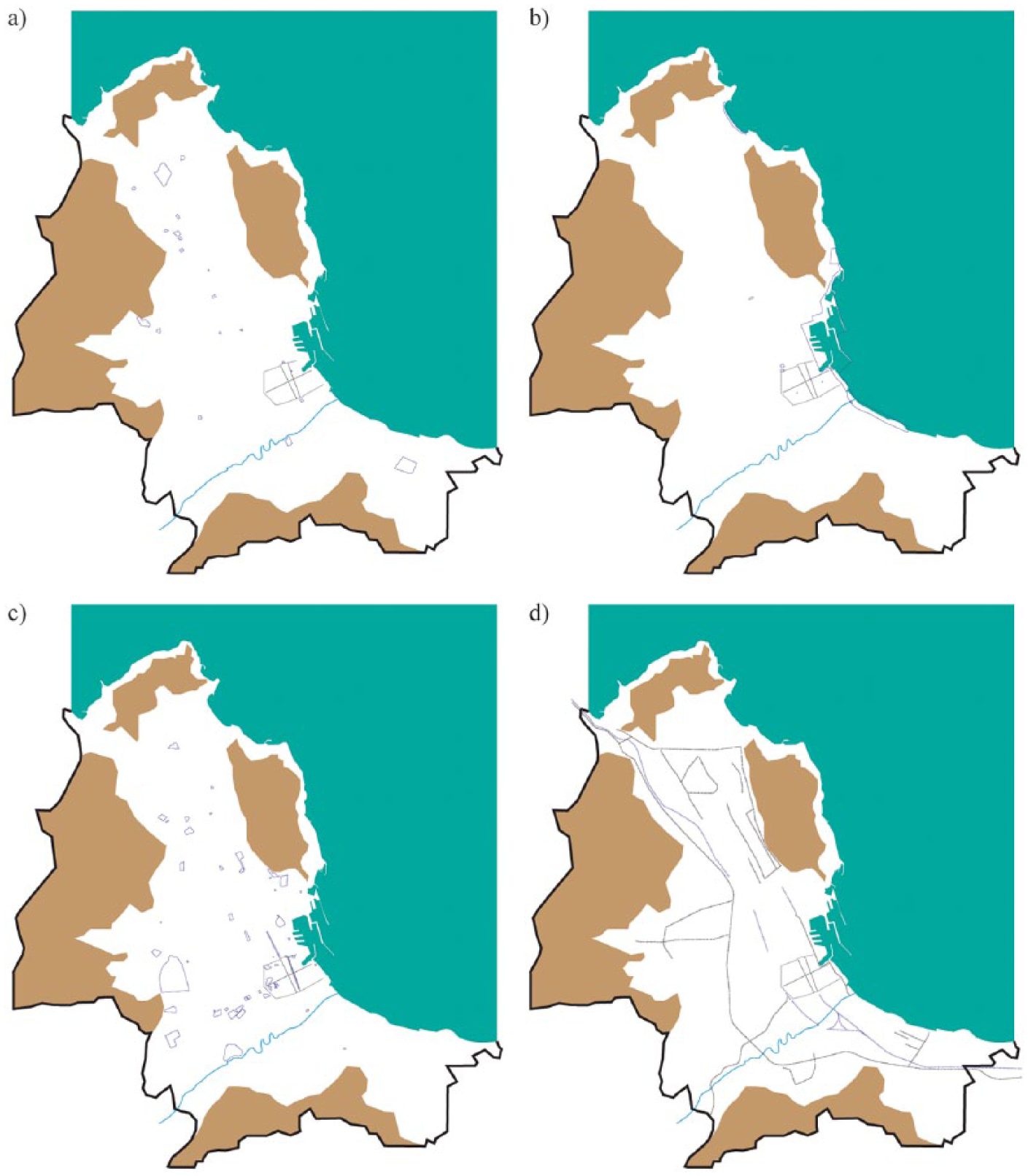
Residential developments have been included on the map when these are provided with common spaces, roads, parking, and services and designed to be secluded from the surrounding urban fabric. Two typologies have been observed: walled villa developments and walled block developments. A great variety of entities is observed, from small developments made of a few residential units to three developments covering 50/75 hectares, each hosting around 200 villas, and a development consisting of 12 blocks, with around 5,000 inhabitants. The biggest entities were often created though the privatization of public streets. I detected 177 walled villa developments (Figure 1a) located within the peripheral areas of the municipality and the northern plains and 1,058 walled block developments (Figure 1b), mainly concentrated in between the central urban area and the low-density peripheries. The historical evolution of walled residential developments shows three phases (Figure 1c):
In the 1970s and 1980s, massive urbanization sees a prevalent role for walled blocks.
In the 1980s, walled villa developments begin to be built, up until 1990, in two clusters, in the northern plains and in the western periphery, and then during the 1990s, walled villas developments characterize the suburbanization of the municipality’s outskirts.
Since the 1990s, urban restructuring developments in the central areas are dominated by walled blocks.

{Spaces of fear} in Palermo: (a) walled single-family houses developments; (b) walled residential block(s) developments. (c) a + b + urbanization phases: up to 1940 (red), 1970 (orange), 1990 (yellow); and (d) spaces of compelled seclusion. Color figure available online.
As far as security measures are concerned, in addition to omnipresent walls/fences, CCTV systems and entrance guard posts are found in most developments. Proactive measures typically used in GCs, such as 24-hour patrols and real-time video surveillance, are, however, not used—Italian regulations on CCTVs (Garante per la Protezione dei Dati Personali, 2010) permit data to be recorded and used only for justified purposes, and real-time surveillance is thus forbidden. Another peculiarity of the local version of fortified residential developments is the absence of any explicit references to the issue of security when advertising the housing units, though this is also the result of Palermo’s real estate market being historically characterized by small, family-run enterprises that rely on informal networks. Broadly speaking, relatively weak correlations between fortification of residential developments and discourses on security are found.
Enclosure, Hetero-Seclusion
Two spaces of compelled seclusion/exclusion have been found (Figure 1d). The history of the Zen, a council housing district built during the 1970s and 1980s in the northern plains, is a well-known story of spatial seclusion and social exclusion, though with some peculiarities (Lo Bocchiaro & Tulumello, 2014). Its utopic modernist design was reflected in the failure of realization phases, the squatting of most housing units, and the extreme poverty of its settled populations. Disinvestment (i.e., the buildings for public services were never constructed, several dwellings are still waiting for a water connection) characterized the phases that followed, as did organized crime gangs’ firm exertion of influence on local communities. Since the 1980s powerful stigmatizing rhetoric has been developed by social media (Fava, 2007), and when a new phase of real estate development (of mostly affluent walled villas developments) was implemented in the surrounding area, the construction of an oversized ring road brought about the spatial seclusion of the district. Rhetorical discourses’ capacity to shape the policy across the district is exemplified by Bonafede and Lo Piccolo’s (2010) account of how a participatory planning process was blocked by the municipal government, which was “concerned” by the risk that public participation may permit the “Mafia” to influence decision making.
The second space of exclusion to be studied is a perfect example of the conditions endured by Roma populations in Italy—conditions described as “appalling” (FRA–European Union Agency for Fundamental Rights, 2009, p. 72). Palermo’s “nomad camp” began in the early 1990s when a group of Roma people who had been evicted from a dwelling in the Zen district squatted in an area of the Favorita park: a “temporary” arrangement that still exists today for the lack of any effective housing policy and for the strong stigmatization over the Roma people (Tulumello, 2013b). The camp has never been formally recognized—according to the town plan, the area is a park—and no policies for dealing with its inhabitants’ housing issue have ever been carried out. As a result, the area is a legal “void” and its inhabitants live under the permanent threat of eviction.
Post-Public Space
The shopping mall is a brand new reality in the metropolitan area of Palermo, insofar as the first mall opened in 2009—with three malls existing in the municipality currently and four more under construction in the metropolitan area. Seventeen smaller commercial facilities—built in the past 15 years—mimic the mall by offering pseudo-public spaces (Figure 2a).
{Spaces of fear} in Palermo: (a) shopping malls and similar entities; (b) privatized public spaces and buildings; (c) fortified public spaces and buildings; (d) infrastructures and fragmentation.
Nine privatized public buildings and spaces have been identified (Figure 2b). They are areas or buildings with historic, architectonic, or positional values, capable of producing high rent revenues and conceded for use, to the substantial benefit of the private partner. Access is regulated by the beneficiary private entity, often with access fees. One key example is that of a wide portion of the urban waterfront, now walled, surveyed by cameras and managed by the port authority. As such, it is officially a public space but is in fact run by private investors. 3 The other entities are Mondello beach, which for decades has been managed by a private enterprise paying a very cheap lease and is fenced-off during the summer season; Vittorio Emanuele square, where an underground private car park has been built by Palermo’s first project-financed public–private partnership; a public garden (Palmeto delle Cattive), which is transformed into nightclub during the summer season; five public buildings (Villa Costa, Villa Filippina, Ex deposito locomotive Sant’Erasmo, Palab, Expa) renovated with public funds and conceded to private firms—in most cases, nightclubs.
A total of 55 fortified public spaces or buildings have been mapped (Figure 2c). In all, 34 buildings are fortified for reasons of use—military and public security facilities, the national bank, the courthouse. Twelve administrative buildings, all built or renewed in the past decade, have been fortified when their usage requires no such fortification. In recent years, public access and use have been affected by fortifications, fences, and patrols in eight public spaces: areas adjacent to fortified buildings; walled and controlled public gardens; public spaces fortified during special events, as in the case of streets surrounding the football stadium, closed and patrolled on match days; or two central shopping districts heavily patrolled during temporary pedestrianizations (see Palermo’s poster on INURA New Metropolitan Mainstream project, www.inura.com).
Barrier
Thirty infrastructures—24 roads and 6 railways—restrict or impede mobility in the direction transverse to their longitudinal development (Figure 2d). The principal cases are the urban ring road that breaks the urban territory in two, isolating some neighborhoods and dividing others; the road axis that, together with the aforementioned fortification of the urban waterfront, separates the city from the sea; and the previously mentioned ring road that secludes the Zen district.
Debate: Replications and Deviations From the Theory
The practice of mapping spaces of fear in Palermo confirms some elements of mainstream theories. During the past four decades, the securitization and seclusion of the residential environment, often through privatization of public streets, have been clustering in the urban territory. More recently, late suburbanization processes (Casanicchia et al., 2006) are shifting new walled, residential developments in the outskirts of the metropolitan area; although no quantitative data exist, a growing offer is found in real estate advertising. Two areas of exclusion have been identified, where physical separation, stigmatization, and legal-institutional voids are used to “blacken” (Yiftachel, 2009) some “uncomfortable” issues. Germinal privatization and fortification of public spaces/buildings are found to have taken place in recent years, at the same time as demands—both by public and private entities—for the implementation of video surveillance systems is shown to be growing (Tulumello, 2013a). Most processes are occurring in central areas, which can be explained by two factors: the launch, in the 1990s, of the regeneration of the historical center (Azzolina, 2009; Cannarozzo, 2000), and the recent success of shopping malls—here the classic story of the “reaction” of local governments to the success of malls resonates. Infrastructural systems have fragmented the urban territory, and a case exists of their use in spatially containing a “problematic” district.
Yet some peculiarities and discordances to theories reviewed in the section “{Spaces of Fear}: A Taxonomy” are to be highlighted, in relation to the local context and historical patterns. The diffusion of spaces of fear in Palermo shows temporal differences as compared to other Western contexts. Fortification and privatization of public spaces are happening late, and this is connected to the socioeconomic “delays” mentioned above—for example, the late creation of the conditions for investment by multinational promoters as a result of the criminal influences (Cannarozzo, 2000) or the historical absence of a strong economic fabric (Trigilia, 1994). Although walls and fences have been a characteristic of residential production over the past four decades, an explicit social construction of “secure” GCs is not found. This mirrors the broader case of Italy more widely—Cascina Vione (Milano) is considered the very first GC in the national territory (Ciulla, 2011)—as can be explained by the historical civic and public dimension of its cities (Petrillo, 2000). The processes of clustering and fragmentation of the urban territory of Palermo are fuelled by two diverging engines: technical/institutional planning means—such as infrastructural network planning—and the lack of effective land use regulations, which has permitted disordered urban growth and the creation of enclosed residential entities designed without considering the surrounding urban space.
The production of some spaces of fear has been and is less explicitly connected with the issue of security, as is the case for walled residential developments, and as such it is necessary to take a closer look at the underlying socio-political processes. Although the global paradox of urban fear characterizes Palermo and Italy, the security rhetoric is less grounded on global concerns—such as those following the September 2001 terrorist attacks—and more on local/national ones (Tulumello, 2012, 2013b). In a context marked by relatively weak democratization of local politics and bypassing of consensus building, some spaces of fear are the result of discursive relations of power (see Bonafede & Lo Piccolo, 2010; Lo Bocchiaro & Tulumello, 2014) rather than of the spatialization of global concerns around security depicted in mainstream theories. In the next section, concluding comments on the space between these “replications” and “deviations” are provided to suggest some direction for new theoretical understandings.
From {Spaces of Fear} to “Fearscapes”
This article has discussed the process of the spatialization of urban fear—for its growing relevance in the Western world—in the city of Palermo. A spatial approach and the practice of mapping have been used to explore the relevance of spaces of fear in the construction of a contemporary city expected to be relatively less influenced by global processes. What is the role of spaces of fear in segmenting the physical city (of Palermo)? The maps of Enclosure, Post-Public Space, and Barrier, represented together (Figure 3a), show that in the past few decades, spaces of fear are among the main features of urban production. One may expect such patterns in global cities of the “geographies of fear” (Davis, 2006). The inverse of the map (Figure 3b) shows how infrastructural systems create longitudinal fractures while clusters of secluded areas break the continuity of the urban fabric. A trend for more fragmented and polarized urban tissues is to be found moving from the historical center toward the peripheral areas, following the historical evolution of urban production.

Fearscapes in Palermo.
According to the “deviations” highlighted in the previous section, a reframing of mainstream theories is necessary to discern how the spatial patterns expected of cities shaped by global processes may be replicated, in different contexts and times, by particular processes. Evidence from Palermo would suggest that there is a need for less global/hegemonic and more discursive approaches to the spatialization of the geographies of fear. In other words, spaces of fear may emerge, rather than from linear hegemonic trends, through a complex frame resulting from the collision of, and conflict between, global trends and local peculiarities: exclusion policies practised by powerful agents plus technical means of planning plus an absence of effective planning regulations plus scarce democratization, and so on. On these grounds, building “safe” and static theories around the worldwide spatialization of urban fear is an unattainable task.
I would suggest that the convergence of a “global/hegemonic” and a “local/discursive” dimensions is crucial to unmask the paradoxes of urban fear and deconstruct the inherent concept of {spaces of fear}. The “global/hegemonic” dimension treats urban fear as a by-product of global power-relations, looking at: first, the way the mass media uses narratives about crime to build an audience (Glassner, 1999) and the effects on people’s perceptions (Heath, Kavanagh, & Raethompson, 2001); second, the use of global discourses about terrorism and risk for creating mass anxiety, justifying “emergency” security policies and attacks on civil rights (Oza, 2007); and third, how political discourses on fear and crime shape the consensus on anti-welfare politics (Bialasiewicz, 2006). The “local/discursive” dimension stresses the local production of fear on two bases: on one hand, the inherent conflictuality of urban space(s) made of differences continuously reproduced, often with exclusionary aims (Sibley, 1995; Young, 1990); on the other, the need for neoliberal (local) governance to create frames of perceived inclusion (Miraftab, 2009) around the construction of oppositional categories such as “we/the others,” “safe/dangerous” (Hutta, 2009)—hence the discursive construction of feelings of fear in urban policies such as “revitalization” or “regeneration” (Kern, 2010; Smith, 1996).
More nuanced theories are needed to unmask the urban “spaces that entail fear.” These should be critical, multilayered, and well-balanced across global processes and local power relations. The spatial approach of this article is a first step, and more studies are needed at different scales and with different approaches—for example, the in-depth analysis of specific planning processes. Some preliminary reframing of existing theories is suggested following the outlined taxonomy (see the section “Mapping {Spaces of Fear}: Palermo”):
Enclosure. Spaces of seclusion/exclusion are restructuring contemporary cities. With the aim of understanding why millions of people commit “social suicide” (Monterescu, 2009), secluding themselves by choice, these processes should be theoretically adjoined with their antithesis, the forced seclusion/exclusion of certain populations and areas. A complex combination of issues should be taken into account: exclusive conceptions of “community” (see Sennett, 1977/2002; Young, 1990) versus rhetorical exclusion of some populations; states of normative “exception” (Agamben, 2003) used for creating spaces of exclusion, removal, and privilege; and local planning systems and their effectiveness in regulating and designing urban production.
Post-Public Space. The multifarious privatization and fortification processes that exist can be explored around their common ground: the resulting erosion of public rights to the city and the omnipresence of rhetoric discourses. However, each case is inherently multifaceted and unique; hence the need to explore individual context and justification patterns. In the context of Southern European cities, rhetoric surrounding the “need for modernization” often overshadows the “classic” discourses on disorder and crime (Frois, 2013).
Barrier. Infrastructural systems are fragmenting urban territories, either via unexpected side effects or by explicit intention; hence the need to question both the socio-spatial dimensions of technical planning and the political significance of mobilities in spatial planning (see Ureta, 2008).
In summary, we need to question the political significance of spatialities (Keith & Pile, 1993) and the politico-economical dimensions of fear in planning in ordinary cities—as advocated by Leonie Sandercock (2002). From this perspective, Lefebvre’s (1974) theory on the (re)production of space is crucial in exploring relational/conflictual relations between “spatial practices,” institutional/hegemonic “representations of space,” and experienced “representational space.” Similarly, this article has suggested that urban fear is at once a spatial/discursive practice, the result of hegemonic representations and policies, and a trigger for less civic urban lives. We should be aware that often, {spaces of fear} are produced by factors quite different from the actual danger these spaces hold.
I shall therefore conclude by turning the concept of {spaces of fear} on its head via a linguistic trick. According to Gold and Revill (2003), the discursive dimensions of both landscape and fear are generated at the intersection of different spheres: “the practical and the reflexive, the natural and the cultural, and the affective and the rational” (p. 36). However, [landscape] also refers to an ensemble of material and social practices and their symbolic representation. In a narrow sense, landscape represents the architecture of social class, gender, and race relations imposed by powerful institutions (Zukin, 1991, p. 16).
Two opposed but converging conceptions of power and production are mobilized by the concept of “landscape”: the hegemonic and the discursive—the same approaches I have suggested for a critical understanding of the paradoxes of urban fear. Moreover, landscape is a category generated by the distance between an observer and the observed object (Desportes, 2005, p. 10). We should be aware that if we reduce such a distance, “living” some urban spaces and fears rather than accepting their representations, we may discover that they are not (always) two faces of the same coin, that they are not spaces of fear. Those areas of contemporary Western cities that we provisionally termed {spaces of fear} may be more properly understood as “landscapes” of fear: “fearscapes.”
It is my contention that this linguistic approach, together with its conceptual/political dimensions, is crucial for the deconstruction of the complex dynamics of power relationships, spatial (in)justice patterns, hegemonic relations, and discursive fears contained in the increasingly prevalent spaces of the Enclosure, Post-Public Space, Barrier. We—as researchers and as citizens—should therefore stop assuming urban fear as a “fact” and security as a “social demand.” It is time to critically engage with “fearscapes” and their role in the fragmentation and erosion of the civic role of the urban space. If we stop accepting {spaces of fear} as a matter of fact, and start questioning the spreading “fearscapes,” we would come to understand that, in the safest and most fearful cities, “there is indeed nothing to fear but fear” (Debrix & Barder, 2009, p. 411).
Footnotes
Acknowledgements
The author is grateful to Marco Allegra, for precious insights on an earlier version of the article, and to the two anonymous reviewers, whose comments were enlightening and supportive.
Declaration of Conflicting Interests
The author(s) declared no potential conflicts of interest with respect to the research, authorship, and/or publication of this article.
Funding
The author(s) disclosed receipt of the following financial support for the research, authorship, and/or publication of this article: Simone Tulumello is funded by the Fundação para a Ciência e a Tecnologia (SFRH/BPD/86394/2012 and PEst-OE/SADG/LA0013/2013).