



Abstract
This article offers exploration of one spatial aspect of crime in the divided city: the disproportionate concentration of crime events along Jerusalem’s former socio-historical border (known as ‘Green Line’) that is clearly reflected in a spatial analysis of crime. Offering insight into this phenomenon, an ethnographic investigation reveals the manner in which neighbourhood residents cope with crime by blocking entry to it from the east, thereby reinforcing and reproducing already existing urban divisions. This second, qualitative layer of research enables us to follow urban boundary work in action, which is important, as focusing on boundary work (as opposed to borders) offers insight not only into divided cities as fact but into the mechanisms, logic and culture that reproduce and reshape their urban divisions. In contrast to hegemonic analyses that highlight the importance of macro-politics in shaping the lines that divide the divided city, this article considers crime, and the way residents struggle against it from below, as a central mechanism that reinforces and reproduces the divisions of the divided city.
The wall is located on the route of the international border. . . If there’s an Arab in the neighbourhood, he will immediately be asked what he is doing there. You defend yourself, so you don’t have to be aggressive. They know this is the framework, like in America, where everything has its framework.
This article explores a key spatial aspect of crime in the divided city: the disproportionate concentration of crime incidents along Jerusalem’s former socio-historical boundary (Brantingham and Brantingham, 1993) (known as the ‘Green Line’) that is revealed by a spatial analysis of crime in the city. Offering insight into this phenomenon, an ethnographic investigation reveals the manner in which local residents cope with crime by blocking entry into their neighbourhood from the east, thereby reproducing historical urban divisions. Here, we highlight the process by which crime concentrates in boundary areas, prompting local residents to take action to fortify the socio-political boundaries between them and their ‘others’ and, in so doing, transforming them into physical borders. 1 Somewhat surprisingly, this project of separation was led by the neighbourhood residents’ committee, which clearly identifies with the right-wing Israeli political parties for which unification is a pillar of their political doctrine. In contrast to hegemonic analyses that highlight the importance of macro-politics in shaping divisions (Wonders and Jones, 2019), this article considers crime, and the manner in which residents struggle against it from below, as a central mechanism that re-divides the city thereby revealing it as another mechanism of boundary construction.
The formation of borders along social boundaries that attract crime, I will argue (Figure 1), serves as a mechanism for reproducing division within the divided city of Jerusalem. In neighbourhoods with strong residents’ committees that fight for separation, the urban pattern of crime materializes into physical walls that re-divide the city. The same residents’ committee that supports and identifies with right-wing parties on the national scale struggles to separate itself from East Jerusalem in order to restore the personal sense of security of those it represents.
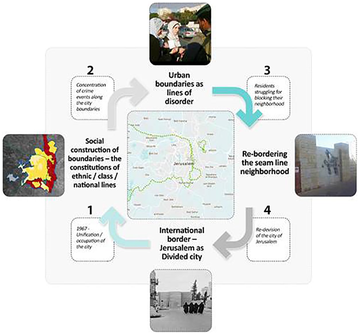
Re-bordering the seam line neighbourhood.
Theoretically speaking, this study locates itself at the junction between crime-place theory and urban sociology, primarily in its consideration of the overlap between the spatial analysis of crime and the social contours of urban conflict. This article’s primary contribution, however, is neither its account of the intensity of border work in cities, which has been well demonstrated in the past, nor its highlighting of the spatial pattern of concentration of crime incidents along borders, which the literature has also shown; rather, its significance lies in the finding that the concentration of crime incidents along urban boundaries leads to a call by residents to (re)build borders, thereby translating socio-political boundaries into physical borders. In this way, the ethnography sheds light on the paradoxical position of the residents’ committee, which on the national scale stands for the unification of Jerusalem but on a day-to-day level struggles to separate itself from the eastern side of the city.
Ethnography of the everyday reality of seam line neighbourhoods populated primarily by Mizrachi Jews (Jews of the Middle East, Asia and North Africa), who immigrated to Israel in the 1950s and have experienced poverty and ongoing discrimination, is ethnography of the spatial ideology of the Israeli right wing. Indeed, many interviewees expressed troubling, stereotype-ridden views of their Palestinian Arab neighbours. As is frequently the case in crime studies, these views are distinct from the data itself, as the foundations of fear are typically based on impressions, as opposed to the Excel tables that consolidate the official data (Quillian and Pager, 2001). From a research perspective, I determined that great added value could be achieved by delving into the daily life experiences and logics that lead residents to adopt these positions.
The article’s theoretical first section contextualizes the study within two fields: the criminology of place and urban sociology. Its second section considers the subject of divided cities both as a socio-historical phenomenon and a theoretical construction, and its third section presents the methodology that was employed to generate the empirical evidence presented in the article and engages in a discussion of the limitations and advantages of this methodology. The fourth section is divided into two parts: a presentation of the findings supported by spatialized crime analysis, and a presentation of the fieldwork conducted in the seam line neighbourhood of Musrara, which conveys residents’ views of and counteractions to crime incidents. The article concludes with a discussion of the study’s findings.
Theoretical background
Border disorder
Theoretically speaking, our point of departure is the dialectical perception of borders not as sites of separation but as zones of contact (Anzaldua, 1987). Borders evoke an urge to cross them and are situated as a means of organizing encounters under new social and legal codes. This approach views the border construction process as an expression not only of a political layout but also of normative, cultural and economic context (Hirschfield et al., 2014).
The primary function of the word ‘disorder’ is its role as a distinguishing concept—that is, a term created solely to designate the opposite of order. Comaroff and Comaroff (2007: 134) argue that ‘violence and the law, the lethal and the legal, constitute one another’. Order and disorder are, in short, mutually constitutive.
Sociologists and anthropologists who have studied the border mechanism (Zerubavel, 1981) have also noted the role of line-marking as a means of assigning meaning, rather than as a mechanism of exclusion, and call for understanding border construction as a key to the creation of social order. When we study the way in which people distinguish—or draw lines—we also learn how they assign meaning (Zerubavel, 1981: 3). For this reason, border and disorder, and particularly the manner in which the two are linked, require critical examination. According to Sennett (1971: 9), the basis of the aspiration for social order is ‘the search for purity’—that is, modern man’s desire to perceive the social world and himself ‘by pushing away the dirt’ (Sibley, 1995: 14).
As noted in the introduction, the present study’s contribution lies primarily in its documentation and analysis of urban borders ‘in action’ as opposed to boundaries as ‘social facts’. The notion of ‘boundary work’ (Gazit, 2010) illuminates the strategies that group members employ when constructing symbolic divisions between in-group and out-group (Cornell and Hartmann, 2006). Put differently, boundary work enables us to grasp more clearly how divisions are actually carried out (Lamont and Molnar, 2002: 168). Analyses of border construction layouts are crucial to an understanding of social order (Sibley, 1995: 72).
The main trend in current research in this field focuses on the links among the neo-liberal economy, widening socio-spatial gaps, the creation of urban borders, the eradication of public space and intensifying city violence (Caldeira, 1996; Davis, 1992). Some other scholars, who have also depicted the link between city polarization and the militarization of the crime world (Wacquant, 2008), perceive crime as a relationship that portrays national, ethnic and social class struggle (Albright et al., 2013; Ilan, 2011). The spatial manifestation of criminal activity as a specific hotspot is thus inherently associated with the ways in which urban space is divided up by different borders.
When social segregation becomes ‘social fact’, a door is opened to a new set of research questions that link neighbourhood crime to racial spatial division. Peterson and Krivo (2010: 73), for example, have asked how segregation at the city level contributes to crime among African Americans in comparison to whites and have concluded, based on a link between segregation and crime rates, that ‘racial residential segregation is indeed harmful to the creation of safe communities’. Their book Divergent Social Worlds considers the concepts of ‘neighbourhood’ and ‘segregation’ from a sociological perspective, asking questions about employment, poverty, neighbours and other relevant issues (2010: 7).
Crimes in spatial context
Criminologists have examined the link between urban space and crime, referring to the phenomenon as ‘space-centralized crime’ (also known as the ‘law of centralized crime’) or ‘hotspots’ (Eck and Weisburd, 1995). This line of investigation, which depicts sets of patterns of criminal activity centralized within small areas of the city (Wang et al., 2014), can be traced to Cohen and Felson’s (1979) work on ‘routine activities’. A decade later, Sherman et al. (1989) highlighted the spatial uniqueness of crime, a relatively small percentage of which occurs randomly throughout the city and a high percentage of which is site-specific. The multitude of research generated the hotspot thesis, and Eck and Weisburd (1995) crafted a concept that facilitated transition to site-specific theory. Following the development of spatial investigation, this thesis has been validated from several different perspectives (Ratcliffe, 2004).
The concept of the hotspot has had a significant influence on the academic community and has developed into a fundamental element shaping the urban law enforcement policies employed by various authorities (Braga and Weisburd, 2010; Sherman and Weisburd, 1995). One major question that haunts the literature on hotspots, which revolves around the issue of predictability, concerns how we explain the disproportionate occurrence of violent incidents at these specific locations. Criminological theory has been dominated by studies that employ two basic units of analysis: the individual and the community (Shorta et al., 2010). These studies are typically guided by the following three major questions: (1) Why did a particular person commit a crime? (2) Why does a certain type of crime occur more frequently in one society than in another, or more frequently now than in the past (Ceccato, 2009)? And (3) How are these incidents associated with different urban dynamics, such as planning strategies (Montoya, 2015), public housing schemes (Albright et al., 2013; Lens, 2014) and gentrification (Papachristos et al., 2011)? These analyses oscillate from the scale of the city as a whole (Craglia et al., 2001), to that of the neighbourhood (Papachristos et al., 2011; Peterson and Krivo, 2010), down to the level of the individual street corner (Hirschfield et al., 2014; Ratcliffe and McCullagh, 1999).
Researchers have addressed different dimensions of this question, with some focusing on the notion of setting (Sherman, 1995) and others highlighting urban design as an explanatory variable (Jeffery, 1971). From an architectural and city planning perspective, Newman (1973) has proposed the concept of the ‘defensible city’, linking architecture and urban planning to violence prevention. More recently, an increasing number of studies have discussed the importance of analysing micro-places (Weisburd, 2004: 284) and examining the political dimensions of crime-related organized violence in the city (Vigneswaran, 2014).
In a 1993 study, Brantingham and Brantingham highlight three spatial patterns that characterize the concentration of crime incidents: edges, paths and nodes. The urban mosaic, they maintain, creates and is created by urban borders (Brantingham and Brantingham, 1993: 17), which can be either physical or social (boundaries such as economic and social lines). In addition to the cognitive structures of the city, this is what creates urban territories. A series of studies undertaken between 1942 and 1986, they explain, note the concentration of crime incidents along boundaries, producing what they refer to as the ‘edge effect’ (1993: 17): The edges may create areas where strangers are more easily accepted because they are frequently and legitimately present, while the interiors of neighbourhoods may constitute territories where strangers are uncomfortable and subject to challenge. Alternatively, edges may contain mixes of land uses and physical features that concentrate criminal opportunities. This seems particularly likely on edges formed by major roads.
Brantingham and Brantingham’s work placed the question of urban borders and boundaries on the agenda of criminology. Others have also shown an interest in border areas and have asked whether changes to border form (for example, through the construction of a bridge linking two previously separate areas) impact the intensity of crime (Ceccato and Haining, 2004). Other scholars have investigated the impact of lines of ethnic separation in border cities on the patterns of crime in these cities (Martinez et al., 2008) and on the dynamics of crime (enforcement, mutual impacts) between two sister cities on different sides of the Mexican-American border (Albuquerque, 2007). Vagg (1992) also argues that borders define the rates and attributes of crime. In his study of the border between China and Hong Kong, he explores the relationship between the border and types of offences and highlights three types of crime: smuggling; illegal immigration; and armed robbery.
The divided city: Jerusalem between conceptualization and history
The divided city, in which internal boundaries are drawn according to sharp ethno-national and class cleavages (Auga et al., 2005; Bollens, 1998; Monterescu and Rabinowitz, 2007), is both a central conceptualization and a concrete research arena. This section relates to both. The divided cities of the Balkans, the Middle East and Europe are demographically partitioned along ethno-national lines, designating them as global sites of contest, conquest and compromise. Five of the most well-known cities of this kind—Belfast, Beirut, Jerusalem, Nicosia and Mostar—have long been flashpoints of international conflict between states characterized by oppositional national identities and strategies (Calame and Charlesworth, 2012).
Divided cities are also distinguished by patterns of social segregation and social fragmentation (Monterescu, 2011; Weiss, 2011; Yiftachel and Yacobi, 2003) and present a formidable challenge to the construction and maintenance of conspicuous social boundaries among various social groups. According to Yiftachel and Yacobi (2003), the mixed city reflects clear patterns of segregation between a dominant majority and a subordinate minority within a setting they theorize as urban ‘ethnocracy’. The mixed city is a site of multiple contact zones involving different forms of ethno-national interactions and negotiation (Monterescu, 2011).
Based on an analysis of the urban regime of fear in Belfast, Lysaght and Basten (2003) argue that in divided cities, which are based on regimes of segregation, the main pattern of violence is sectarian in character. In the case of Northern Ireland (as in the case of Jerusalem), the macro-politics of peace agreements (or, in the case of Jerusalem, the constitution of the separation wall) ‘brought significant change to everyday life [. . .] Sectarian violence, however, remains an aspect of daily reality for many people’ (Lysaght and Basten, 2003: 226). According to Lysaght and Basten (2003: 226), divided cities constitute sectarian space: that is, space based on defined codes of behaviour. Here, they rely on the earlier work of Boal (1996), which analyses the spatial movement of Catholics and Protestants on Cupar Street in West Belfast. Their article concludes with an account of sectarian behaviour such as changing names and changing clothes when crossing ethno-national boundaries.
In contemporary Jerusalem, as in Belfast, political context has been recognized as the main arena for understanding the dynamics of border construction (Savitch and Garb, 2006), and national conflict lies at the core of interpretations (Shlay and Rosen, 2010). In this section, I challenge this set of interpretations and attempt to further develop our understanding of the intersection between the construction of international borders ‘from above’ and boundary work ‘from below’. Drawing on the experience of divided cities, I posit that such urban regimes are shaped not only by national macro-conflicts but also by dynamics of segregation, class tensions, social gaps and crime.
A brief history of borders in Jerusalem
As noted above, the divided city is not only a theory of urban relations but also the research arena of this study. Delving into the case of Jerusalem requires a brief conceptualization of the long and complex history of the construction and deconstruction of urban borders and boundaries in Jerusalem.
In 1947, Great Britain resolved to terminate its mandate over Palestine and to return decision regarding the territory’s future to the United Nations. In November 1947, the UN General Assembly resolved to divide Mandate Palestine into a Jewish and an Arab state. This decision sparked the outbreak of the 1948 war, which concluded with the ceasefire agreements of 1949. These agreements established an armistice line separating Israel from the Jordanian-ruled West Bank and the Egyptian-ruled Gaza Strip, which came to be known as the ‘Green Line’. To illustrate the resulting complex reality, Figure 2 presents the separation map on three different scales, each highlighting the Green Line: (1) the national scale (Palestine-Israel); (2) the regional scale (the West Bank and Jerusalem); and (3) the urban scale of the city of Jerusalem, which the Green Line traverses.
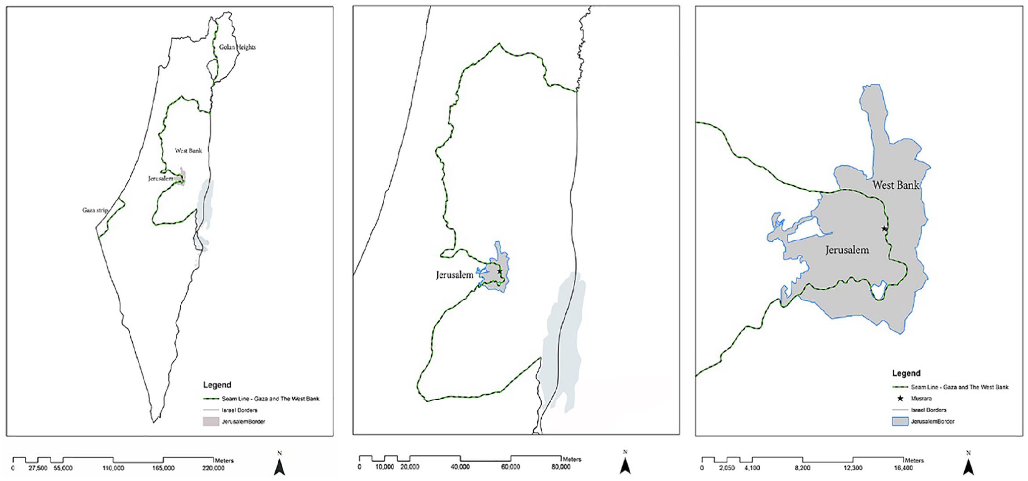
The Green Line on three different scales.
In 1949, the city was divided between the nascent Israeli state and the Kingdom of Trans-Jordan (Figure 3), and it remained divided in this manner for the following 19 years. To mark the border between the two countries, a 7 kilometre fence was constructed through the city’s centre, complete with guard posts and fortifications (Narkis, 1986), and landmines were planted across the city.
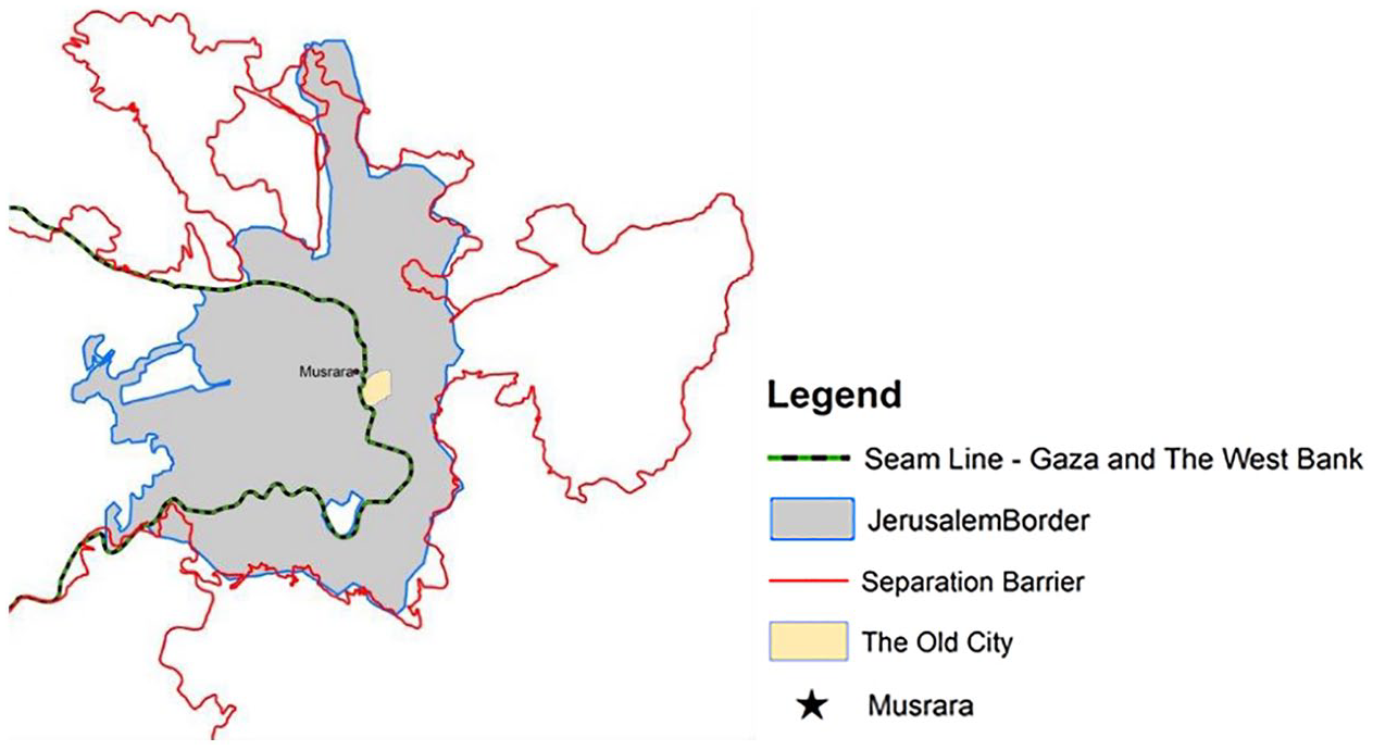
Jerusalem and its internal borders and barriers.
Following the Six-Day War (1967), the fences and mines were removed, although, unlike the Palestinian Arabs living within the Green Line, the Palestinian citizens of east Jerusalem were not offered Israeli citizenship. Rather, their formal status vis-a-vis the Israeli state is that of ‘residents of the city of Jerusalem’. As Wonders and Jones (2019) argue, the ‘doing and undoing’ of borders is related to residents’ formal status as citizens or marginalized groups.
In response to the terrorist attacks of the 1990s, public groups in Israel called on the state to build a wall separating Jerusalem from the West Bank, although the state failed to articulate its position on the idea. In February 1993, Jerusalem Mayor Teddy Kollek and Jerusalem District Commander Rafi Peled decided not to wait any longer for state funding and supportive government policy and constructed a wall between Armon Hanatziv (East Talpiot) and Jabel Mukaber, marking the beginning of the genesis of the separation wall between Jerusalem and the West Bank.
During the Second Intifada (2000–2005), also known as the Al-Aqsa Intifada, the tension, killing and destruction reached new heights of intensity. Faran et al. (2005) have claimed that hesitancy and unclear state-level policy was responsible for turning the Jerusalem District into a local policy maker and creating a situation in which decisions regarding how to handle security issues were made at the municipal level.
In July 2001, the Israeli government adopted the ‘Jerusalem Envelope’ (otef yerushalayim) plan, which mandated Jerusalem’s separation from the West Bank 2 and had two major effects on the ground: (1) it cut off East Jerusalem from the Palestinian urban continuum and prevented Palestinian access to the holy sites in the city; and (2) it imprisoned tens of thousands of people in a distinct closed-off area (Savitch and Garb, 2006). To sum up this section, we emphasize that the border investigated in this article is not only an urban border but one that previously functioned as an international border, and that the question of its future—that is, whether or not it will ultimately revert to serving as an international border—constitutes a major point of contention in the Israeli-Palestinian conflict. Ceccato and Haining (2004: 808) stress that urban borders are not the only borders that clarify issues of crime—so do international borders, which symbolize the endpoint of control and enforcement of state institutions. This issue is particularly important in understanding the Jerusalem seam line, as, up to the present, even though Israel formally controls both parts of the city, the enforcement mechanisms operating in each differ significantly from one another.
But physical and political borders are only part of the dynamic of divisions in Jerusalem. The urban texture of Jerusalem, which is full of socially constructed borders that promote separation in the city, is also relevant. This includes the different languages spoken by the city’s diverse population; and, perhaps most importantly, the differing socio-economic status of the city’s different neighbourhoods.
Jerusalem is one of the poorest cities in Israel (Jerusalem Institute, 2013), with social disparities that are considerably wider than those found in other cities of a comparable level of socio-economic development. As demonstrated in Figure 4, poverty and other aspects of marginality go hand-in-hand with the ethno-spatial divisions of the city, making the city ‘Separate and Unequal’ (Chesin et al., 1999). Poverty rates in East Jerusalem are extremely high, with 77% of all Arab families and 83% of all Arab children in the region living under the poverty line.
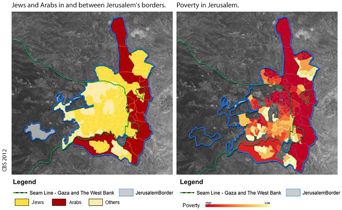
Jerusalem boundaries: Ethno-national division (left) and poverty (right).
The separation wall cuts off the residents of East Jerusalem from the large cities of the West Bank, thereby disconnecting them from sources of economic opportunity. As a result, the Green Line is not only an urban dividing line between Jews and Arabs but also between haves and have-nots.
Methodology: Crime spatial analysis
This present study’s methodological procedure had three stages: the first was devoted to data collection, which took approximately two years to complete due to the complexity of acquiring the permits necessary to access urban crime data; the second involved the spatialization of this data using a GIS system; and the third focused on interpretation based on fieldwork in the seam line neighbourhood of Musrara.
Stage I was conducted after receiving the necessary permits and after the Israel Police’s Research Department’s provision of data pertaining to reported crime incidents in Jerusalem for the years 2003, 2005 and 2010. 3 The first data file contained a detailed description of the time of each incident, its location in the city and the type of place in which it occurred (e.g. outdoors, in a private home, in a restaurant, etc.). The file was divided into sheets that included the following categories of legal offences: breaking and entering; car theft; sex-related offences; robbery; extortion; knife possession; drug-related offences; destruction of property and other property-related crimes; and murder. The police declined to provide the exact location of each incident but were willing to indicate the statistical area in which it occurred. Although this was initially regarded as a disadvantage, this data turned out to be beneficial for two primary reasons: (1) many areas in which Palestinians live lack street names, and the provision of a statistical area was preferable to a blank space stemming from an inexact address; and (2) usage of the statistical area highlighted the scale of the neighbourhood and evoked neighbourhood-based interpretation.
The methodology also suffered from a number of weaknesses. In the first place, as noted by current research, only 40% of all crime incidents are reported (Pollock, 2012) and much fewer in the case of minority groups, which constitute a large portion of the city’s population. The second weakness stems from the fact that crime is socially defined by law and norm (Pollock, 2012). The spatialization of crime incidents has also come under criticism. For example, Gregory and Pred (2007) have claimed that spatializing phenomena conveys an essentialist perception of ‘place’ and that the analysis it provides is not flexible enough to remind us that place is a result of social construction and is not, in itself, something that invites or inhibits violence. The methodology’s third weakness is effectively conveyed by Comaroff and Comaroff (2007), who argue that crime research frequently uses quantitative data and statistics to create crime scenes, and who are critical of the fetishism of statistical analysis and the manner in which it affects the formation of social reality.
Stage II—the spatialization of crime incidents according to statistical areas, from broad general categories to a focused investigation—involved the collection of data pertaining to all crime incidents in the city during the years in question, and their subsequent mapping in urban space.
Stage III: Interpretation and Analysis
The present article comes in response to a call to deepen our knowledge regarding the criminology of place by means of data-based empirical research and space-related statistical tests. However, I maintain that ethnographic research is necessary in order to provide an interpretive framework, as the identification of spatial patterns in themselves is not the ultimate goal of this study.
Ethnography offers the interpretive framework that best presents and clarifies the ways in which people assign meaning (Geertz, 2008). To this end, I conducted a field study in the tradition of cultural anthropology: that is, an attempt to produce a thick description of a neighbourhood that is documented to the level of transcription in a field diary; spending time in community space and maintaining ongoing trust-building contact with community institutions such as the local community centre, the neighbourhood residents’ committee and a group of artists that was operating in the neighbourhood. My guiding principle was detailed documentation that would enable me to learn the language of the subjects (emic), and analysis of this language in order to learn the internal syntax of their culture.
My fieldwork in the seam line neighbourhood of Musrara included tours, the documentation of neighbourhood events, participant observation in neighbourhood and community centres, and in-depth interviews (eight full documents interviews) and many informal conversations with members of the residents’ committee and other local residents. Most of the interviewees, and the individuals with whom I was in contact, were men of Mizrachi origin between the ages of 50 and 60 who occupy seats on the residents’ committee and other positions at the community centre. Many are also active in right-wing political parties. Following the tradition of urban anthropology, I conducted an urban investigation of the neighbourhood’s planning and architecture. Ethnography is a meeting point between the researcher and the group about which he or she seeks to learn, and I am therefore compelled to say something here about my own sociological profile. I was born to a Mizrachi family; my father and mother immigrated to Israel in the early 1950s, from Iraq and Iran respectively. My Mizrachi background opened the door for me when it came to building trust with the local residents, and I felt as if they saw me as ‘one of their own’. Being a woman was a challenge, as the public figures in the neighbourhood were all males, creating a situation in which I felt insecure. Throughout my work, I maintained the ethical principles of recording conversations only with permission, keeping in contact with the interviewees and sharing later drafts of my work with them to receive their comments.
Findings
The data analysis was conducted in funnel form, progressing from general to increasingly more focused analyses. The first stage was to map all crime incidents, with the aim of spatializing as much data as possible. Using GIS, I examined the distribution of incidents and identified end members to generate a bell curve that most accurately reflected the natural breaks of the incidents. I found one outlier that distorted the bell curve and decided to exclude it from the analysis.
The analysis revealed three general patterns (see Figure 5, right side):
Statistical areas containing commercial and industrial activity (Givat Shaul, Romema and the Central Bus Station, Malcha Mall and the Zoo) attracted a large number of crime incidents.
The ‘ring neighbourhoods’ 4 along the city’s eastern edge (Gilo, French Hill and Pisgat Ze’ev) also experienced a high concentration of crime incidents.
Crime along the urban seam line. Incidents in the city were centralized along a north–south axis running through the heart of the city, through the neighbourhoods of the American Colony, Yemin Moshe, Talbia, the German Colony, Baqa and Talpiot, with two prominent turns along the route—one on Jaffa St towards Romema, and one southward, ending at Malcha Mall and the Zoo.
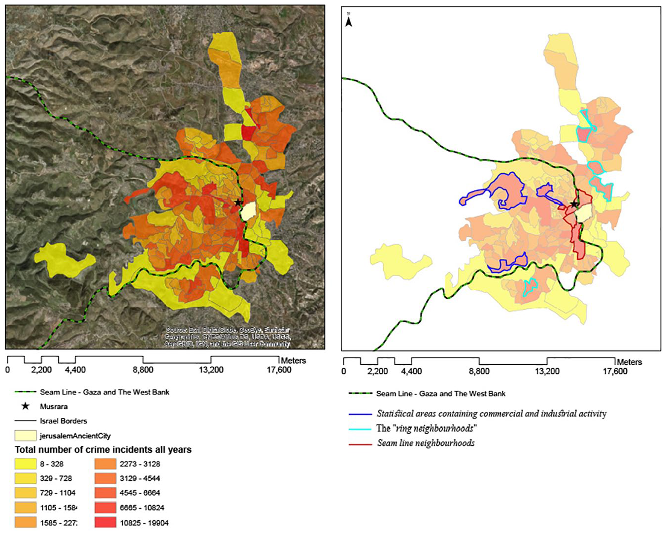
A spatialization of crime incidents in Jerusalem: 2003, 2005 and 2010 (right) in three concertation areas.
When considering the absolute numbers, 9008 incidents were recorded in statistical zone 532 (Baqa and Talpiot), similar to Musrara and other seam line neighbourhoods, reflecting numbers that were two to three times higher than in neighbourhoods located farther from the seam line and from commercial and industrial zones. The concentration of crime incidents around commercial and industrial zones is a well-known phenomenon in the criminology of space. However, the pattern I found most interesting was the multitude of incidents along the socio-political boundary, including the ‘ring neighbourhoods’ (large Jewish neighbourhoods that were built in the eastern part of the city and that are surrounded by Palestinian villages, refugee camps and neighbourhoods) and within the Green Line. This pattern was documented in the past and was theoretically framed as an urban ‘edge’ (Brantingham and Brantingham, 1993).
Criminals seeking to maximize profit could be expected to operate in the wealthier, western part of the city, as it contains some of the city’s more established neighbourhoods and is less effectively monitored than the seam line area. However, the findings revealed that fewer crime incidents occurred in this region, and that the perpetrators of crime in the city tended to focus their activity on the meeting points of inequality.
In summary, the findings presented in this section reveal a centralization of crime incidents around Jerusalem’s ethno-national boundaries: the urban seam line and the ring neighbourhoods. The centralization of crime incidents was also observed in the city’s industrial and commercial zones and was identified at varying intensities in different time and offence-type analyses.
How do seam line neighbourhood residents cope with crime?
Ethnography in a seam line neighbourhood
With these spatial statistics of crime incidents in hand, I ventured into the field to ascertain how local residents perceived and coped with the high rates and centralization of crime. To this end, I engaged in fieldwork in the Jewish neighbourhood of Musrara, located just west of the seam line (the experiences and perspectives of Palestinians living just east of the seam line are currently under investigation).
The people whom I met during my fieldwork, Jewish residents of Musrara, focused on two primary aspects of the phenomenon: the ethno-national aspect (reflected in remarks such as ‘the Arabs come [here] to commit crime’) and the spatial aspect (reflected in remarks such as ‘they come from there, the eastern part of the city’). As shown by Comaroff and Comaroff (2007), disorder has its place, which in this case is in the east. This interpretation is also clearly manifested in the perceptions of residents, who have the impression that Arabs are the sole perpetrators of crime incidents along the seam line, despite the police data that reflects that this is not the case. In actuality, Musrara residents and Jews from neighbouring areas are responsible for approximately one-third of the crime incidents perpetrated in the neighbourhood, with the other two-thirds divided equally between Palestinian citizens of Israel and Palestinian residents of the West Bank and East Jerusalem. When I shared these figures with the members of the residents’ committee, they were surprised and did not accept them as fact, 5 reinforcing Lysaght and Basten’s (2003: 226) conceptualization of ‘sectarian crime’ and ‘sectarian spaces’; from the residents’ perspective, crime has to do with ‘them’, the Arabs, who come from ‘over there’, from the east.
Border nostalgia
This is where the border ran, and for me it is still a border. Up to here it’s ‘us’, and from this point on it’s ‘them’ [. . .] There was a protective wall here [. . .] The war ended, they dismantled the wall, and now it’s open. But when I look at it, I see it as it was when I was a child [. . .] It’s still a border.
The above quote by S reflects the effectiveness of ethno-national borders in indicating where ‘they’ end and ‘we’ begin. Even though the physical border was dismantled in 1967, the urban border still exists as a sociological apparatus and continues to affect the residents’ experience of fear of both crime and terrorism: I am 58 years old and unashamed to say that I am afraid to go to the Old City like I used to as a child [. . .] Since the Intifada,
6
you don’t feel safe walking around freely, and you truly are in danger [. . .] that all kinds of extremists will see someone with a skullcap and want to stab me.
It was particularly surprising to discover that numerous residents missed the border, which appears to contradict the fact that many neighbourhood residents who were interviewed for the study are supporters of right-wing parties that support a ‘unified Jerusalem’ and the idea of the ‘Whole Land of Israel’. In their everyday lives as residents of a seam line neighbourhood, however, they seek to fortify the border and, by doing so, to reinforce their separation from their Palestinian neighbours.
Also surprising was the extent to which the border of the past still exists in the collective consciousness of neighbourhood residents. Indeed, as Sibley (1995: 32) suggests, boundaries provide residents with a sense of security, as reflected in the following words of a local community centre employee: When there was a border there were no thefts. I used to live with Arabs. There was friendship. They were different people. Now it’s all over. It’s all hatred. But you can’t blame them. They grew up with nearly 40 years of hatred. We used to live in poverty but in peace. An [international] border is better. We should give them everything [they want] on the condition that we won’t see even one Arab.
The above quote touches on a number of issues that help us better understand residents’ interpretations of the situation. This interviewee also maintains that the international border provided security for neighbourhood residents by effecting their clear separation from the Arabs, thus strengthening the traditional sociological and anthropological theories that perceive disorder as a state of contamination. With the dismantling of the border, the possibility of friendship with the Arabs vanished as a result of decades of hatred. An Arab’s entry into the neighbourhood creates an internal split and a sense of anarchy, and the absence of a physical border between East and West Jerusalem creates a perception of lawlessness. This offers further support of the theory that views the desire for order and purity as the origin of the demand to construct a border.
One long-time resident depicted the dismantling of the border as the point at which all the problems started, as it allowed drugs to begin entering the neighbourhood: ‘After 1967, when the border was opened, there was an epidemic of drugs [. . .] It was very difficult. Even those who weren’t into it were forced to—even children.’ The outcome of the Six-Day War in 1967 resulted in the elimination of the international border and the city’s ostensive ‘reunification’. However, the findings of the present study indicate that the border’s physical removal actually achieved the opposite result: though physically ‘unifying’ the city and doing away with the threat posed by Jordanian snipers, it posed a new threat for neighbourhood residents: crime and, two decades later, large-scale terrorist attacks and a nationalist uprising. Paradoxically, the removal of the international border, which was perceived as a victory on the Jewish-Israeli national level, ultimately emerged as a source of insecurity for neighbourhood residents due to its disruption of Jerusalem’s urban ethnocracy (Yiftachel and Yacobi, 2003). According to one community centre employee: ‘[y]ou see an Arab near your house. You ask him what he’s doing here and he says he’s looking for a job. He’s lying. He came here to steal.’
Under conditions of equal ethno-national status and unequal social status, border zones become points of contact and friction, not separation (Anzaldua, 1987). And the wider the disparities, the fiercer and more demanding the attraction is to the weaker side. This dynamic is reflected in the assertion, made by the above-quoted community centre employee, that ‘you can’t contain these Arabs—they come to you’, and in the following words of a salesman in a neighbourhood antique shop: Today, an Arab is allowed to sit in the public garden. The municipality built benches for the residents. So he comes and sits. You can’t say anything to him. I didn’t have a problem with this until the number of thefts and robberies became too much. They take everything and leave nothing; they even dismantle copper wires, which they can sell.
Bring back the border, bring back the order
Field research conducted in the neighbourhood revealed active ‘boundary work’ (Gazit, 2010) by residents aimed at reinstating the border. Moreover, residents did not perceive the construction of the wall as an action taken from a position of political strength but rather a solution they were dragged into for two reasons. One was their sense of powerlessness with regard to municipal and regional geopolitical issues: ‘What can you do to them? Transfer them? You can’t. The Supreme Court protects them and you can’t act against it. So what else can you do? Build a wall.’
These findings are interesting, particularly in light of the fact that the research literature commonly perceives separation and border construction by dominant groups as a manifestation of power and exclusion (Sibley, 1995: 16). In this case, however, we note the weakness of the powerful—the point at which the dominant majority confronts the limitations, or borders, of its power. The residents’ boundary work has a political alibi. It was originally planned as an ‘acoustic wall’ to protect them from the noise created by Rt 1, which, according to Pullan et al. (2007), functions as an internal border: The wall is located on the route of the international border. It’s something psychological. If there is an Arab in the neighbourhood, he will immediately be asked what he is doing there. You defend yourself so you don’t have to be aggressive. They know this is the system, like in America, where everything has a system.
Residents’ second explanation for demanding a wall was even more intriguing. Asking them about their understanding of the concentration of crime in their neighbourhood prompted them to speak about the socio-economic conditions on both sides of the Green Line: ‘I was here at the time of the Black Panthers’, explains one resident. ‘We struggled because we faced hardship. But when we had children we were concerned about them and raised them to be good kids. In our days, an Arab didn’t dare walk through here.’ Such statements on the part of neighbourhood residents reflect the perception of a reverse relationship between the socio-economic and cultural conditions of the neighbourhood and its residents on the one hand, and their relationship with their Arab neighbours on the other hand. That is to say, when things improved and the next generation were raised as ‘good kids’ (as opposed to rougher, more street savvy youth who did not refrain from using violence to deal with problems), it marked the beginning of the end of the neighbourhood. In the words of one active resident: ‘[t]he neighbourhood will be gone. I predicted it. The children lack the strength to deal with it.’
Once the neighbourhood rebelled and some of the residents moved away, those who remained appear to have felt abandoned and in need of a protective wall: Teddy Kollek [the mythological former mayor of Jerusalem] wanted to construct Rt 1. The architects presented a 9 metre wall, with a terrace overlooking Damascus Gate, a bridge and a waterfall. They wanted to build gates in every neighbourhood to facilitate crossing. I asked them to close off the neighbourhood and the terrace. Teddy Kollek told them to do what I said but to leave the waterfall. We still have a border because we built the wall. That’s the border. We asked for the wall. Twenty-five years ago, before the Six-Day War, there was a fence. They built the wall on the exact same spot.
In this context, it is important to emphasize that the architect’s intention was not only to provide for an acoustic wall but also to establish links and encourage connectivity between the two parts of the city, with entry points that would facilitate passage from one side of the city to the other. Local residents, on the other hand, fought to keep the wall sealed (Figure 6).
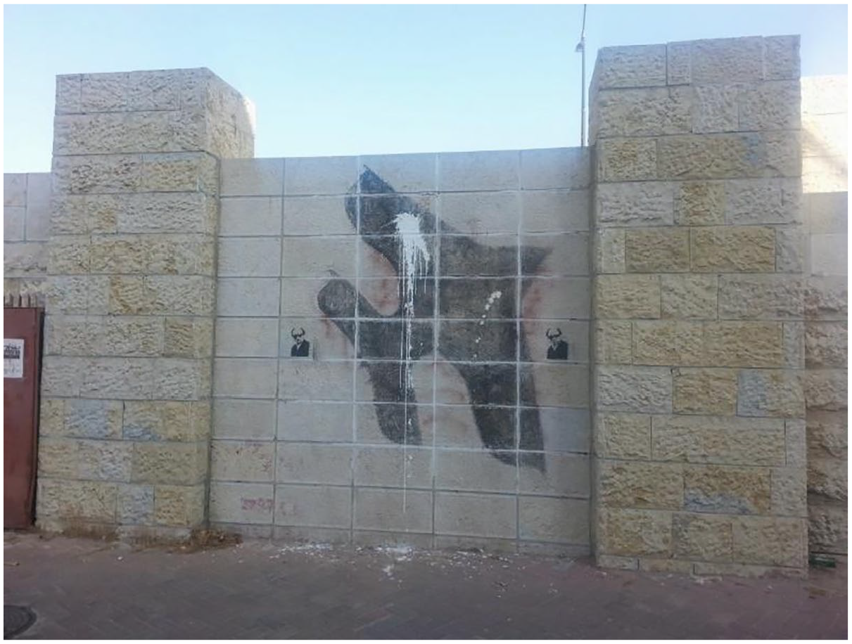
The wall that was built on the historical border between East and West Jerusalem, separating the Old City (near Damascus Gate) from Musrara. Photograph by the author, Oct. 2013.
According to the current chairman of Musrara’s residents’ committee:
7
They wanted to build a tunnel to the other side, but we were concerned that it would attract junkies and danger. They wanted to build a passage in the middle of the wall, and we objected. We didn’t want people crossing over directly into our homes, robbing the elderly, committing burglaries and stabbings. They finished the project in the early 90s. The city engineer said that when they build the gate, they’ll call it the ‘Gate of Peace’. I told him that when there will be peace, we will open the gate.
The reconstructed border in its current form is not a hermetically sealed international border but rather a physical border with narrow passages that can easily be sealed off by barriers and monitored by cameras as deemed necessary. But the wall nonetheless serves as a border that sustains and enhances the power of the route of the former international border. The wall also furthers the neighbourhood’s interest in creating order and restoring its ethno-national purity, and at the same time runs counter to the state’s aim of creating and maintaining a unified Jerusalem. This study sheds light on the manner in which local residents operate on the neighbourhood scale and, in so doing, reshape the geopolitics of Jerusalem.
Conclusion
Setting forth from a spatial crime analysis that revealed a concentration of incidents along Jerusalem’s internal urban seam line, this article proposed a deconstruction of an intriguing urban dynamic. My fieldwork offered insight into the manner in which residents have been coping with the concentration of crime incidents, enabling me to trace the social dynamic of the boundary work that reproduces and reshapes urban divisions. Sociologically speaking, the boundaries of Jerusalem are becoming real in their consequences (Thomas and Thomas, 1928). The concentration of crime incidents endows the boundaries with strength and physical expression in the built environment.
The urban transformation under examination here was the product of work by the neighbourhood residents’ committee, which presented its demand for a border to the professionals charged with planning the seam line. They demanded a border not out of a sense of power but rather out of a sense of helplessness in contending with frequent crime incidents, a task which they do not trust the police to carry out effectively. For a variety of reasons, they ruled out other possible solutions, such as ‘transfer’, vigilantism and moving out of the neighbourhood. Under these conditions, when they could turn to no one else to effectively guard the neighbourhood, boundary work appeared to them to be the only solution: ‘[y]ou defend yourself so you don’t have to be aggressive’.
Perhaps most interesting is the fact that the border work undertaken on the neighbourhood level ran counter to state policy and official right-wing ideology, which seeks to maintain a ‘united Jerusalem’. This dynamic is one more milestone in the historic urban dynamic discussed above: the city’s internal logic and its residents’ demand for ‘order’ and security, as a force that plays an important role in reshaping the internal divisions of the divided city. Indeed, the fact that this grassroots boundary work ran counter to Israeli state policy regarding ‘Greater Jerusalem’ and disrupted the connection between East and West Jerusalem attests to its practical significance. This, in turn, offers new insight into the relationship between bordering and boundary work and contributes to our understanding of borders in divided cities in general and Jerusalem in particular.
Footnotes
Funding
The author(s) disclosed receipt of the following financial support for the research, authorship, and/or publication of this article: DESURBS - Designing Safer Urban Spaces”. EU funded research project under the Seventh Framework Program, 2014.
