



Abstract
Geomedia reflect the infrastructural, environmental, and practical conditions under which they come into being. By reading traces of and as geomedia in different natural elements, the “thick mappings” of lines presented in this article render the properties of the crossed environments visible. From a historical-anthropological perspective, geomedia have taken on a double perspective in this process since the late 18th century, with the first aerial images. With regard to the movement in the air, on land, and on water, this double mediality concerns the paradox of representing an in situ perspective and simultaneously a line of becoming. Geomedia always exhibit a documentary and a procedural form. These two characteristics are chiasmically linked with each since the Industrial Revolution. Geomedia are practices that reflexively demonstrate how the paradox can be visualized, namely, that a mediated human body on the move is in a stable position, while the surroundings are fluid.
Keywords
Introduction
In a recent study, MIT’s (Massachusetts Institute of Technology) Senseable City Lab explored the “Wanderlust” of people, where and how often we go, by using location records of mobile phone users. Based on the distance and frequency of 8 billion mobility traces, Schläpfer et al. (2021) found the scaling law of human mobility that explains the magnitude and heterogeneity of flows and prominent clusters of attractive destinations.
The universal visitation law for human mobility captures the temporal and spatial spectrum of the movement of individuals. It was only possible to find and visualize this with the aid of the tracking, tracing and mapping capabilities of geomedia (Figure 1). This is a good example of the fact that the way we describe and understand geographies is continuously fabricated and transformed by the tools we use to navigate through these areas.
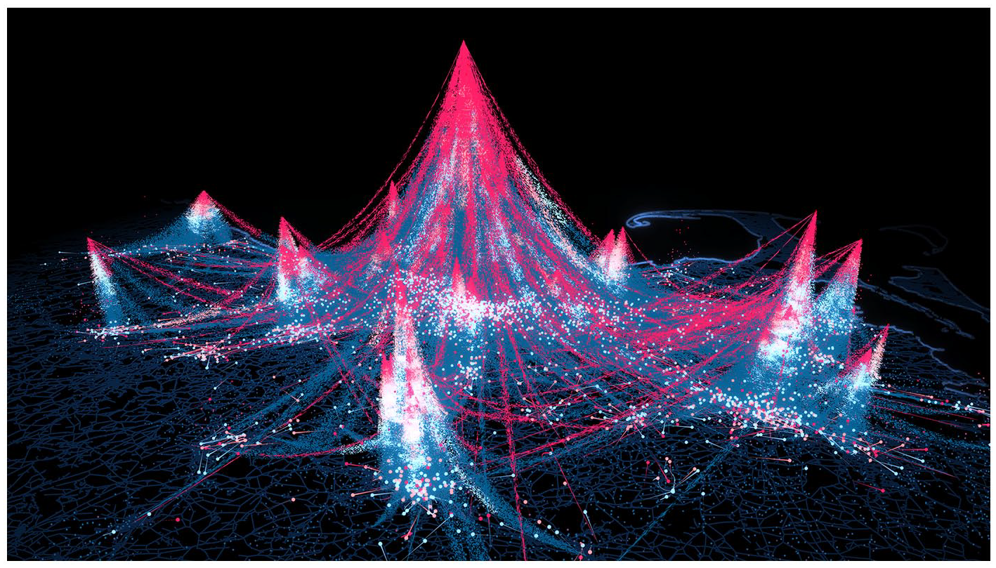
Wanderlust image caption. This image visualizes the flows of individuals across the Greater Boston area as lines (visiting frequency as color, number of unique visitors as width) that form spatial clusters of attractive places, with the height of mountains representing location-specific attractiveness (https://senseable.mit.edu/wanderlust/).
This applies equally to historic geomedia. The aim of this article is to look at different sociotechnical (Edwards, 2003) and cultural techniques (Siegert, 2015) that have created the foundations for geomedia, which continue to have an effect, and are still an integral and vital part of geomedia today.
If we look at the literature on this field (e.g. Fast et al., 2018), we see that the mode of movement is crucial to the current and historical understanding geomedia. For example, for a long time in the history of geomedia, particular emphasis was placed on phenomena and technical means of acceleration of perception.
However, when we are dealing with a documentation of the social and physical environmental conditions that is as accurate as possible, real-time mapping on the move is of particular importance—from a historical perspective, this is initially characterized by the slowness of movement.
This is why the historical genealogy given in the following emphasizes a specific type that is characterized by its slow movement: thus, a form of movement that allows the simultaneous analog recording of one’s own movement based on its speed.
This takes place against the background that the establishment and assertion of geomedia as an independent form of expression and technology is primarily based on its medial binding to human bodies (Lapenta, 2012). This allowed the understanding of geomedia as a tacit technology, smart device, seamless content and everyday practice.
The current expansion of the scope of geomedia through drone media, augmented and virtual reality applications, artificial intelligence or autonomous driving, and so on (Kanderske and Thielmann, 2019) also questions as to what the fundamental determinants in the history of geomedia are.
To this end, Bruno Latour developed the historiographic concept of “immutable mobiles” (Latour, 1990: 26 et seq.), which I refer to below, that places the creation of “optical consistency” (Ivins, 1973) through a uniform image composition in the center of a trajectory of cumulative sociotechnological development. The immutable mobile concept has already been used in the past in media historiography (see Schüttpelz, 2009; Siegert, 2009) and was tested by Thielmann (2016) as a methodological outline for the history of photo-auto guides.
This concept proves to be an interesting method of investigation for the development of “Large Technological Systems” (Hughes, 1987) both generally and, more specifically, for media-technological innovations, as it allows attention to be focused on the movement, circulation, distribution right across social and technical systems (right across humans, non-humans, organizations, territories, etc.). This creates a heuristic model that can be used for the disclosure of a media history that goes beyond analog and digital, physical and virtual, media and geographies, as, according to Latour, sociotechnical innovations obey the maxim:
Anything that will accelerate the mobility of the traces that a location may obtain about another place, or anything that will allow these traces to move without transformation from one place to another, will be favored. (Latour, 1990: 35)
If we follow this argumentation, the selection pressure that produces something like geomedia, therefore, arises from the infrastructural aspect of the accelerated mobilization and dissemination of locating technologies and in situ perspectives, as well as from the stable form character of cartography as a platform, grid, and network for the provision and communication of different media contents.
To date, maps or mapping interfaces like Google Earth or satellite navigation devices have been viewed as the central paradigm for immutable mobiles (Hind and Lammes, 2016; Lammes, 2017; Perkins, 2014), as the logistics of immutable mobiles are developed as a distinct cartographic and thus a-perspective problem.
More specifically, this focuses on the transition from ethnogeography to geography and the question of how “the implicit geography of the natives is made explicit by geographers; the local knowledge of the savages becomes the universal knowledge of the cartographers” (Latour, 1987: 216).
In this process, the focus is on the media-technical use of mobile cartography at the end of the 18th century and the consequences for the accumulation of knowledge that resulted from this, illustrated based on the example of the French geographer and seafarer, Jean-François de Galaup de La Pérouse.
La Pérouse was faced with a transport-technical problem, which simultaneously constituted a media-technical and knowledge-accumulating problem:
how to bring things back to a place for someone to see it for the first time so that others might be sent again to bring other things back. How to be familiar with things, people and events, which are distant. (Latour, 1987: 220)
This is a question that touches on the fundamentals of geomedia studies. The solution he presented was the necessity for the invention of “immutable mobiles”—the continuous increase and combination of the mobility and immutability of inscriptions—as the nucleus for the media-technical superiority of the West.
One of the “extraordinary means” that have to be devised is to use travelling ships as so many instruments, that is as tracers that draw on a piece of paper the shape of the encountered land. (Latour, 1987: 224)
This means that Latour can already be named as an author in the field of the History of Science and Technology who traces (a history of) mobile geomedia. Latour’s immutable mobile approach, therefore, initially recurs alone on the geomedium “sailing ship,” with all the maps, logbooks and instruments for position sensing (e.g. quadrant and sextant) that were onboard at the time.
Latour (1987: 215 et seq.) develops his approach from the specific requirements for control over distance and accumulation of knowledge in “centers of calculation,” to explain how the technological superiority of the West was organized. Geomedia thus play a double role in this understanding, by serving the purpose of mediating between local and universal knowledge. Latour assumes stable geographies and the idea of mobility across a flat territory, which is why environmental conditions are not considered more closely.
The following intends to illustrate the extent to which certain structural concepts became established, also in a decentralized manner and on uncertain terrain, which allow diagrammatic form stability via transformations. More specifically, this deals with the phenomenon of a double perspective of geomedia, by simultaneously unifying an in situ and a procedural perspective in one single representation of a line of action. The following therefore investigates how historical records of traces in the air, on water, and on land have affected the current perception of geomedia.
At the start of industrialization and scientification of perception and the experimentation with new forms of mobility, all three of these natural environments symbolize an uncertain, vague terrain, which is why it rested upon medial representations, not least, to confer stability on these three very different spaces. In all three of these environments, this occurred through a different, but also structurally common, approach of creating a double perspective, as is outlined below.
Airspace, rivers, canals, roads, and paths have themselves created infrastructural conditions that were required to make mobile media and technologies possible. In the following, our gaze is, therefore, to be directed toward how spatial infrastructures formed certain types of geomedia and, vice versa, how the visual representation of terrestrial positions and situations shapes our geographical understanding. In this process, what exactly is the object, the historical genealogy of which is to be traced?
The term “geomedia” obtained its actual construction of meaning once it became technically possible to determine one’s own position during natural human movement and to simultaneously make specific contents and medial applications available as a consequence of this reference to location (Lapenta, 2011; Wilken, 2018). Geomedia are, therefore, constituted by not necessarily being reliant on a technical means, support, carrier or platform (such as an automobile) to develop agency. Nevertheless, the social and political relevance of geomedia only comes fully into play when as many other technical means, carriers, and platforms as possible carry geomedia within and distribute them (McQuire, 2016).
We could also refer to first- and second-generation geomedia: while the first generation still primarily revolved around locative media and its experimental/artistic practices, or an attempt was made to systematically describe the relationship between media and geographies (Döring and Thielmann, 2009), the second generation is connected to the establishment of networked mobile media, such as the smartphone and tablet, in the 2010s. However, this aspect is to be left to one side here for the historical genealogy, so we can concentrate fully on the ontological core of geomedia and their histories.
If we assume that geomedia are primarily coupled to forms of human movement and that they use humans as a carrier medium, then it is helpful to take a historical perspective on them, to establish which media technologies expanded human perception when air, land, and water were conquered in the 19th century (Virilio, 1989).
At this time, there was as yet no stable transport infrastructure that would have ensured that a specific target was reached at a defined point in time. Ship lines and track charts (the cartographic record of a voyage according to the shipboard perception) were used for navigation over long distances out of sight of land when dead reckoning was needed, for example, for finding sea routes to and from East India in the 19th century (Cook, 2006). Railroad lines were only built once the steam engine had been invented. And it was motorization that created the prerequisite for establishing air lines and aerial navigation maps at the beginning of the 20th century (Ehrenberg, 2006; Svatek, 2015). The personal interest I will be pursuing here is the recording of lines that were not yet based on a fixed infrastructure, which conquered new territories before motorization, but still under their own steam, and simultaneously recorded this process while moving along.
From an anthropological perspective, Tim Ingold (2011) has shown that lives unfold not inside places, but through, around, to and from them. He therefore uses “the term wayfaring to describe the embodied experience of this perambulatory movement. It is as wayfarers, then, that human beings inhabit the earth [. . .]. But by the same token, human existence is not fundamentally place-bound [. . .], but place-binding” (p. 148) as everyday life is not unfolded in places but along paths. Through this embodied and inevitable mediated proceeding along paths, humans lay trails that are perceivable as geomedial inscriptions and signs.
For Ingold, this delineating of movement has a fundamental existential meaning. At least for the Inuit, “as soon as a person moves he becomes a line. To hunt for an animal, or to find another human being who may be lost, you lay one line of tracks across the expanse” (Ingold, 2011: 149). Such a native Inuit materialization of movement can be easily compared with modern forms of movement, for example, the sailing practices in discovering the Northwest Passage in the 19th century. The understanding of movement over land or sea ice as tracing lines of becoming is useful as a visual metaphor for the activity streams of data that are processed while using geomedia.
Ingold’s concept was enhanced by the notion of the “digital wayfarer” (Hjorth and Pink, 2014; Pink, 2016) to include the perpetually moving mobile media user in this historical-anthropological trajectory. A structural historical association can therefore be made between the analog and digital wayfarer: both are represented and mapped in their “situatedness in ecologies of place” as well as in their perpetuality of movement and “emerging stories of place” (Hjorth and Pink, 2014: 42–44).
Therefore, it is also useful to read the geomediated production of lines from a historical anthropocentric perspective. The focus of this article is on the constitution of the meaning of human movement and the technical media and infrastructural conditions that help to keep track of such movements in different natural elements. In the following, we will take a look at exactly which media have shaped which understanding of traces in the air, on land, and on water.
In the air
At the end of the 18th century, the hot air balloon was a medium that promised “access to a new world of wonders” (Tucker, 1996: 145). Namely, adopting an observer perspective that had previously been impossible. Historians of science and technology like Thébaud-Sorger (2013: 46) point out: “Certainly balloonists saw the world from above, but they could not transcribe it.” Before the advent of flight, aerial images always demarcated a difference between a drawing based on direct observation and the imagined bird’s-eye view. They refer to something that is not itself visible in an image, but can only be assumed. Hot air balloons were therefore a suitable vehicle for counteracting this speculative momentum through objectification (Tucker, 1996).
The first aerial image is regarded as the “Balloon Prospect from Above the Clouds” (Figure 2), published by Thomas Baldwin in 1786, which was produced based on sketches and field notes during a balloon flight over north-west England he did in 1785, starting at Chester castle in Cheshire (see Kaplan, 2013: 35). What these sketches depict are routes through the sky above the clouds, which look as though a balloon itself had drawn them. The balloon’s path is traced, but what’s below the sketched route cannot be seen entirely as clouds cover the ground. Baldwin’s attention was mainly captured by the forms far below, “rather than the sublime elements of the formless environment in which he is immersed” (Kaplan, 2018: 86). The hand-colored etching renders the different levels visible: the flight level, along which one is moving, the clouds below and the barely identifiable ground.
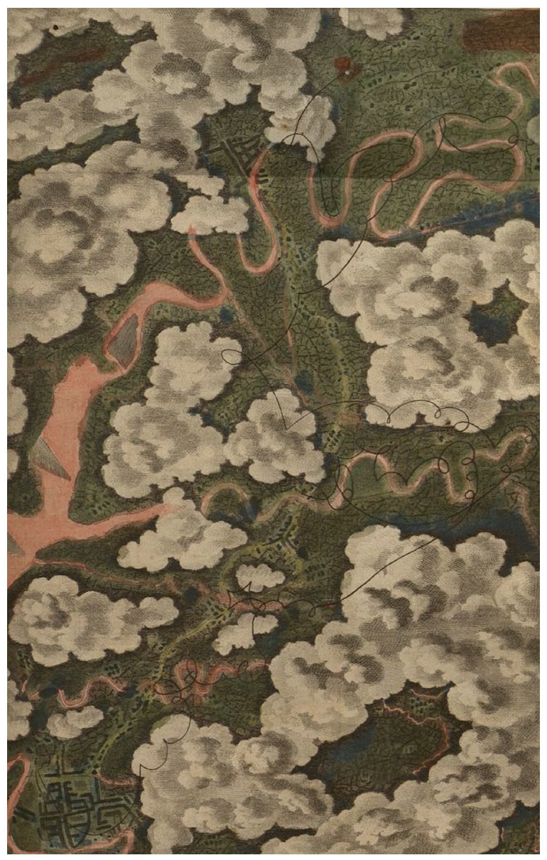
“The Balloon Prospect from above the Clouds” (Baldwin, 1786).
The countryside map that Baldwin had brought along was of almost no use as public roads were barely trackable: “He was entirely lost in the blue fields of air; far above the summits of the clouds; tho’ the balloon was in sight of the Earth, and of the numbers who were gazing at it” (Baldwin, 1786: 147). In this sense, the aerial image from a balloon also reflects the public view people had of these flying objects from the ground. Thus, it can be argued that situated views from above cannot be divorced from their connections to the ground (Southern, 2010), but also not from the connection to the airway they have passed through and that lies ahead.
Baldwin (1786: 1–2) lamented that many accounts of ballooning had been “vague and unsatisfactory,” he complained that “balloon voyagers” had been “defective” in their accounts of “aerial scenes and prospects.” He was therefore searching for access to his own sensations through embodied sights. The vertical perspective and the simultaneous horizontal path of his Balloon Prospect reveal this double mediality. “Aerostatic spacing,” as McCormack (2009) describes it, created an embodied relationship to the unclear ground, as well as to the vague medium traveled through. The first published aerial view based on sketches undertaken by a person in flight is therefore already a geomedium, as it is simultaneously the result of a transitory and situative experience of space. It maps the path that simultaneously created it. This reflexive power is still inherent to geomedia today.
The unruly intensities of aerostatic movement trouble any generalization about totalizing or unified views from above. [. . .] Views generated by this process of “aerostatic spacing” are not so much a limitless gaze from a stable position but a series of fragmented glimpses from a body in movement, vistas interrupted by clouds, and strange optical effects depending on distance from the ground. If early aeronautics hoped for panoramic horizontal or vertical views, often these vistas were stymied by weather conditions or active interruptions. (Kaplan, 2018: 78)
The image attempts to epitomize both elements simultaneously: a moving body that is in a stable position and, at the same time, in movement, as is the case for the “Balloon Prospect,” links two different modes of representation: a tracked route over a period of time and a view from above at a certain point of time. The aim of expanding the view by ever greater heights goes hand in hand here with a tracking of the movement and a situated position in the sky, which simultaneously represents an impossible view in such synoptically overlaid images, “from both ‘nowhere’ and ‘now here’” as Caren Kaplan (2013: 34) describes it.
As Barbara Stafford states, this conferred an intrinsic form of expression on the unrestrained, restive, unstable and swaying condition of flying. “Objects and the amorphous medium that bathes them are ever in motion, sliding away from beneath the eye, evading the pursuing mind” (Stafford, 1984: 24). This disconcerting effect was described by many aeronauts of the 19th century (Turnor, 1865). In this sense, the sensation of remaining still while the visual field appears to be in motion is expressed in the first geomedia. This geomedial quality is also revealed in the lithographies of scientific balloon flights in the 19th century.
Ballooning at that time must be viewed in the context of the contemporary media of (onboard) recording and distribution. The book “Travels in the Air” (Glaisher, 1871) played an important role in popularizing ballooning. James Glaisher, superintendent of the Magnetic and Meteorological Department at the Royal Observatory in Greenwich at the time, documented his balloon flights and illustrated them in lithographies (Figures 3 to 5). In his understanding, the balloon was a “philosophical instrument” (Glaisher, 1871: 22) for field work that, above all, produces data.
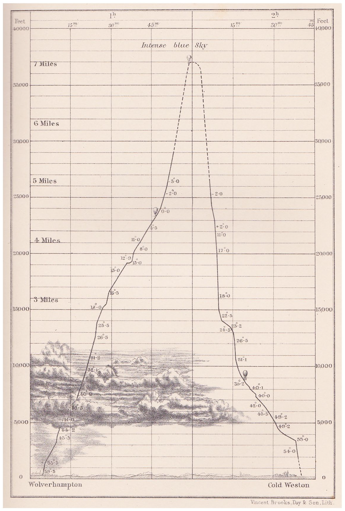
Path of the Balloon in its ascent from Wolverhampton to Cold Weston near Ludlow, 5 September 1862.
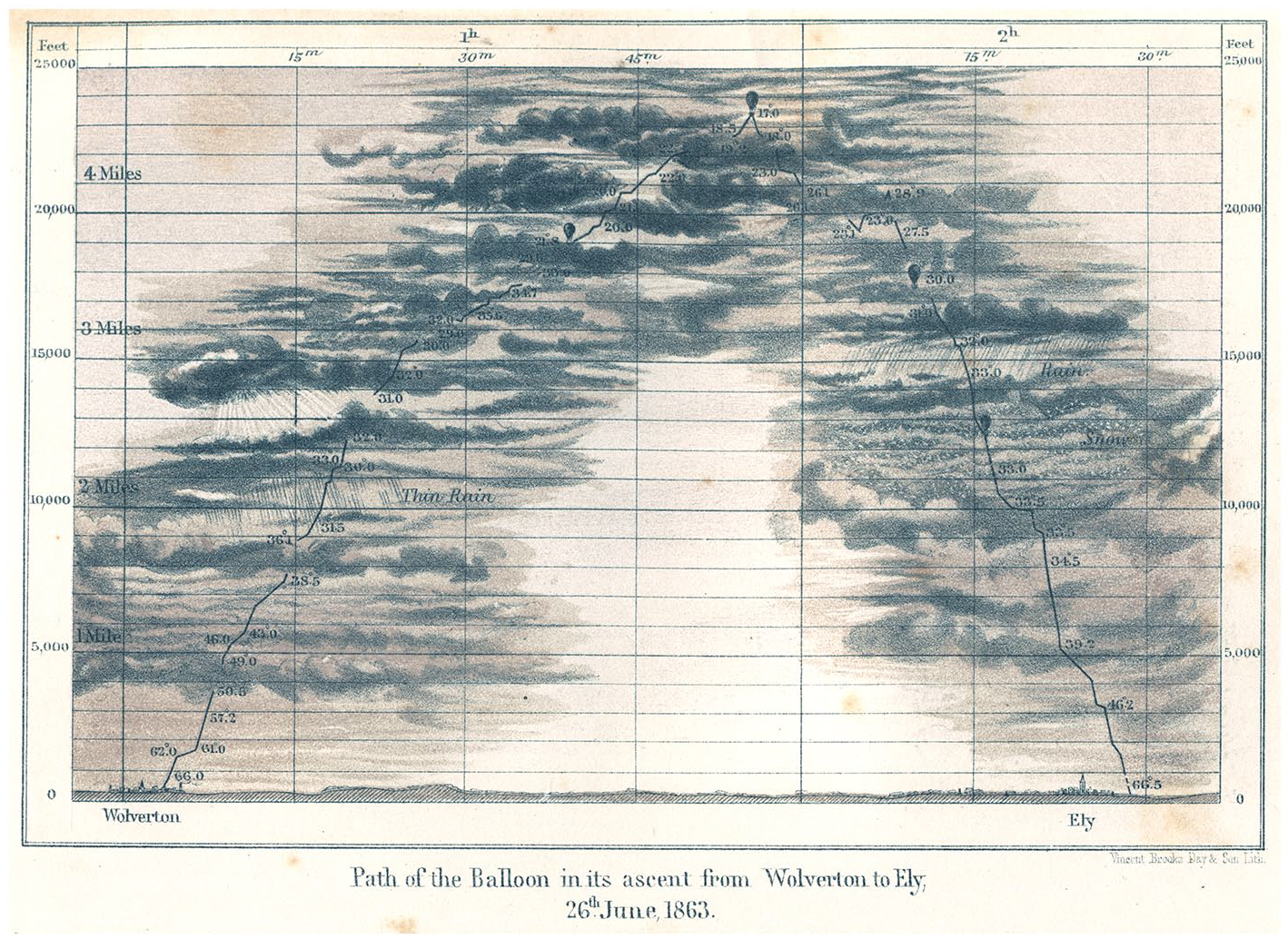
Path of the Balloon in its ascent from Wolverton to Ely, 26 June 1863.

Path of the Balloon over London (at Night), 2 October 1865.
Glaisher’s balloon was an observatory with a lot of different technical instruments, like dry and wet bulb thermometers, hygrometers and barometers, a compass, a chronometer, a lens for reading the instruments, as well as opera glasses. He made observations with these instruments nearly every 30 s and recorded them in a notebook (Tucker, 1996: 154). From a media geographical perspective, it is also important to understand that “Glaisher prepared the instruments and practiced making observations in a limited space” (Tucker, 1996: 162). The expansion of the space that could potentially be documented and the local spatiotechnical possibilities of capturing space were thus inversely related.
A series of sociotechnical factors were, therefore, also relevant at that time, that allowed Glaisher to use the atmosphere as his laboratory. These factors involve attention to the detail, a methodological procedure, punctuality, diligence, accuracy of observation, repetition of small acts like note-taking and self-motivated persons willing to record data (Tucker, 1996: 164). These are characteristics that we often take to be self-evident prerequisites when we discuss digital geomedia today. All the more discipline and motivation was required under the exhausting conditions at altitude, cold and low in oxygen, when compared with observation conditions on the Earth. These sociotechnical conditions are inscribed into geomedia to this day.
Glaisher also tries to map the loss of sensory impressions above a certain altitude (Figure 3). He used a dashed line to visualize “the margins and gaps of consciousness through ana- and prolepses,” as Zindel (2020: 38, own translation) makes explicit in her dissertation. “The dashed line is based on interpolations that are veiled in clouds and does not have much in common with the evidential character of a line in a coordinate system” (Zindel, 2020: 39, own translation), which symbolizes a constantly measurable and objectifiable trajectory. The depicted balloon is, therefore, not only “an instrument for vertical exploration” (Glaisher, 1871: 22) and a medium that allows the passage through imagined spaces, as Zindel argues, but also a geomedium that produces data under all circumstances—including circumstances where the instruments can no longer be read. Geomedia also reveal their traces without human actors, as Glaisher demonstrated. The planless is becoming part of the plan, at least in retrospect.
However, there are also depictions in which the continuity of the trace was illustrated as a hiatus (Figure 4). In the “Path of the Balloon in its ascent from Wolverton to Ely, 26th June 1863,” the flight path is interrupted by dense cloud. The plotted line, therefore, reflexively draws attention to the difficulty of the observation of scientific instruments. The pathway is simultaneously enriched by the media that encompass the air route, if we understand environments and their natural elements as media too (Peters, 2015).
The representation of the airway is broadened by the variable density of the clouds, the rain and snow that surround the balloon car. The balloon is thus not only a geomedium that traces its route, but it also represents the media nearby and through which it finds its way. This is not an interpretation from today’s perspective. Glaisher, himself, did not view the balloon as simply a means of transport. He considered the balloon as an instrument for vertical exploration that has given scientists a “fresh territory” (Tucker, 1996: 166). This involved mapping the altitude of his hot air balloon in aerial images (Figure 5).
Lithographies were produced that linked different spatial concepts to each other: a Cartesian coordinate system with an image of the landscape with a central perspective. The diagrammatically depicted path forms the foreground, behind which the space of the landscape opens up. A space without depth and one with depth are combined. This raised questions with regard to the mediality of augmented reality that are of significance today.
Glaisher used the balloon prospect on London at night to illustrate his flight path. The data production of the geomedium “balloon” is (also figuratively) in the foreground and the subjective view over London is in the background. The diagrammatic altitude data are thus augmented by a first-person perspective and not the other way round, as is discussed with see-through AR displays today (Hofmann and Mosemghvdlishvili, 2014). An objectively measured trace and a subjectively viewed space are combined within a hybrid spatial representation. This makes it difficult to read the space of geomedia they represent.
We are dealing with a recording and representational medium that captures the space in situ and simultaneously over a period of time. This inevitably creates dizziness, which corresponds to the borderline experience of this medium. The vertigo that accompanies the tracing of one’s own track in the air is also still revealed 50 years later in the position control devices that were taken along to record the intrinsic movement relative to the surface of the Earth in the form of snaking lines (Figure 6).

British Air Ministry A.M. Drift Recorder MKII.
For over 120 years, ballooning was shaped by the problem of steering, to which a solution was only found at the beginning of the 20th century, with the advent of motorized airships (Zindel, 2020: 158). Up to that point, a balloon could only influence its altitude, but not the horizontal path along which it was driven by the wind. Movement in space only becomes fluid with motorization and navigational charts with edges once again become curved lines, similar to those that were already documented by Baldwin (1786).
With the rise of airships and motorized aeroplanes at the beginning of the 20th century, trips for meteorological, astronomical, and physical observations intensified and new forms of trace determination were possible (Svatek, 2015). In the 1930s the British drift recorder MKII (Figure 6) was a widely used optical-mechanical calculation machine for determining the drift of an aircraft while following objects passing underneath.
The drift recorder consists of a prismatic telescope that has a series of parallel lines in the focal plane of the eyepiece. These lines could be turned until they are parallel to the apparent motion of objects on the ground. You could also target an object with a metal needle and follow the object while you are flying above it. The needle was connected to a pencil that draws a straight line if you can keep the set course, or a looping, curvy line if there are side blasts of wind (Williams and Branch, 1952: 169–177).
The motorization of air travel, therefore, also heralds a transformation in recording media used to track down one’s own trace in the air. Instruments are no longer simply read periodically, but the current position is followed on a continuous basis. The next step in the evolution of geomedia is thus characterized by the unity of detection and representation, a unity of positional determination and position mapping that is still a key feature of contemporary geomedia.
The ability to steer led to the requirement for technical means that could serve as the basis for deciding to turn in a specific direction. Real-time control over intrinsic movement in space is thus not an achievement of digital geomedia. This is directly associated with the motorization of air travel, which set in train a processuality that was directly linked to the monitoring of one’s own route.
The agency of geomedia is inseparably connected to the movement of a vehicle, as has been demonstrated above. The continuity and unrelenting nature of movement in space and the circumstance that we are dealing with self-powered movement, requiring active intervention and steering, have made the use of geomedia necessary in the air. The same can also be applied to the medium of the bicycle on land. (The following chapter is an updated, revised, and shortened translation of Thielmann et al., 2018.)
On land
The bicycle is a medium sui generis if we base this on the expanded meaning of the term medium, as was primarily represented and made popular by Marshall McLuhan (1964). According to McLuhan, the invention of the wheel already led humans to react to the excess load placed on the feet through faster trade and transport. The bicycle then certainly constitutes an extension to the body within the meaning of McLuhan. The history of science and technology also describes the bicycle as a central actor and mediator of sociotechnological change (Bijker, 1995). It was already regarded as an “earth-friendly machine” in the 19th century (Norcliffe, 2001: 15).
The bicycle only became a medium through its connection to the land (Friss, 2015: 120 et seq.). On one hand, there are many medial representations in the popular magazines of the time, showing bicycles stuck in the mud of unsurfaced country roads (Figure 7). These photographs were taken at the end of the 19th century to epitomize the importance of surfaced roads to the rural population.

A photograph of a road in Washington County, Maine, USA, sent to the Good Roads magazine (N. N. (1894) Don’t get into a rut. Good Roads 5(6): 227).
On the other hand, the bicycle served the purpose of establishing translocality, namely, (a) through the connection of town and country, (b) through local connections to other modes of transport and between settlements, and (c) through the opening up of unknown terrain. Furthermore, the bicycle itself engendered geographical representations in the form of maps and a system of signage and signposts. In this sense, we can discern that the bicycle represents, transforms, and produces geographies. The bicycle therefore fulfills all conditions that are demanded of a rural geomedium, even now, under digital conditions (Ash et al., 2018).
The historiography of cycling routes in the late 19th century faces the challenge of following the narrow, finely branched paths on which the cyclists traveled, based on the traces that have been recorded, can be reconstructed, and are still found.
Rather than beaten trails through wild or unknown regions, however, those narrow, tire-worn passages instead signal the start of searches through a different type of un- charted terrain: the urban, suburban, and rural locales where bicycles can function safely, both as vehicles for recreation and as a means of transportation. Charting a course for those investigations, or taking one’s trace, is as uncertain today as it was a century ago. (McCullough, 2015: xii)
The maps of the time were generally no great help as their scale was too large to find the right route (Osborne, 1899a: 101). A new method of traveling across the land was to cycle in the wagon tracks (Figure 7). So-called “soft roads” that were composed of sand or clay were almost impassable with narrow wheels, apart from during frost. It was, therefore, quite common and in the interests of the coachmen to broaden the wheels of coaches, covered wagons, and so on; these were sometimes 6 inches wide.
These tires had made the county roads where they had traveled almost like a pavement, and he found the owner of the wagon could haul heavy loads with such tires when the roads were in bad condition. On soft roads where the tires had gone over, it made it an easy matter for cyclists to spin over the country. (Quinn, 1968: 20)
It was thus initially quite common for cyclists to follow in the tracks of other means of transport. For example, the corridors between railroad tracks and paths alongside were also used as rural roads (McCullough, 2015: 108), as is demonstrated by the following advertisement of the National Cycling Manufacturing Company (Figure 8). This method increased the probability of reaching the planned destination, or a destination, even on unknown terrain.
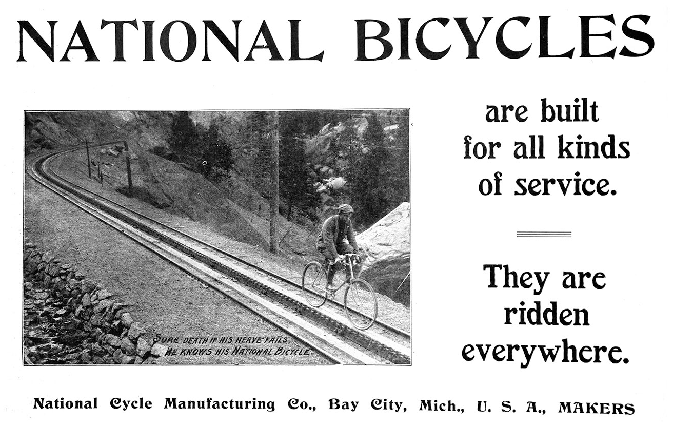
Advertisement for National Bicycles (The Bicycling World 48(1), 3 October 1903, p. 8).
A particular challenge faced in countryside was the paucity of orientation points that were close enough together for bicycle navigation. The field notes made by the individual local cycling club members often recorded places that were mainly known to cyclists who rode around locally (McCullough, 2015: 4). Publicly accessible signage systems that indicated the route were, therefore, essential to travelers who were unfamiliar with the location. The cycling boom at the end of the 19th century led to ever greater numbers of travelers using roads, who were unfamiliar with the surroundings. On tours through rural regions, in particular, cyclists encountered the problem that there were no road signs and traveling without information on the route proved difficult. With the help of the L. A. W. Bulletin, which functioned as a communication platform for the members of the League of American Wheelmen, cyclists drew attention to the central infrastructural problems described above: the poor state of the roads and the lack of signage.
The League of American Wheelmen discovered the practice of mapping through the practice of cycling. The members of the L. A. W. were therefore a network of amateur cartographers who jointly negotiated the process of developing the navigational medium, the cycle map. This process can be reconstructed through the conduct of historical research on the different L. A. W. Bulletins. The road books produced by the members of the L. A. W. were compiled based on voluntary work. The cyclists combined their enjoyment of travel with documenting the state of the roads, from which all members ultimately benefited. Only a few instruments were required for this documentation, all of which were unified with the medium of the bicycle or could be attached to it (Figure 9).
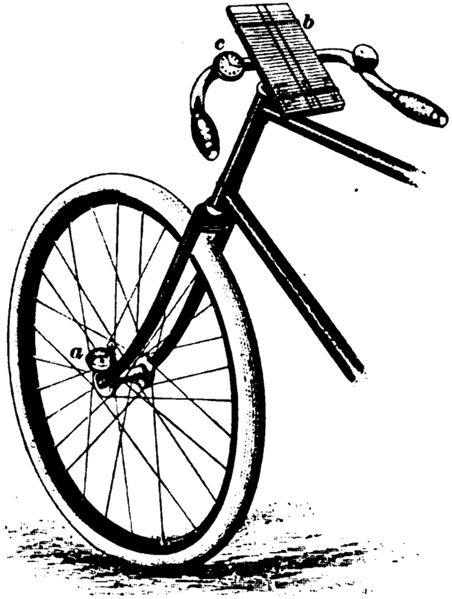
Bicycle with a cyclometer and watch fixed to the handlebars, as well as a notebook for land exploration (Osborne, 1899a: 102).
This geodetic method essentially only required a means of transport (bicycle), a device for measuring distance (cyclometer) and a medium for recording data (notebook). A so-called “cycling watch” was now sometimes also being used to record the intervals between turning points and to thereby illustrate the distance covered relative to the time taken. This allowed indirect statements to be made on the quality of the road and on the elevation profile (Osborne, 1899a: 103 et seq.). The data were collected by mobile groups, on the move, which is why the assumption was made that the individual cyclist could not simply stop to make individual measurements (Osborne, 1899a: 102).
To implement these “measures,” two vertical, parallel lines, representing the road from the subjective perspective of the cyclist, were drawn in the middle of the small pad for stenographic notes (Figure 10). The stenography pad was fixed to a wooden board with rubber bands which, in turn, was attached to the handlebars of the bicycle. This allowed the cyclist to makes notes and observations while riding along, without having to get off the bicycle. The direction in which the cyclist turned off was entered in the middle, based on the distance that had been covered, and the relevant landmarks were noted on the left, which were to serve the purpose of helping subsequent users of the “cycling map” with their orientation.
If the bicycle surveyor be an experienced rider, his map may be so plotted, that grades and conditions of road may be readily expressed, and other information never found on the most accurate maps may be added as a guide for the future traveller. (Osborne, 1899b: 124)

Route mapped with the bicycle on 4 July 1897 from Wilkes-Barre through Dallas to Shawanese, with information on turning points and distance data (Osborne, 1899a: 103).
There was thus clearly great confidence in the skill of the cyclists at this time. They were thought capable of riding over unfamiliar terrain at the same time as documenting it on paper. Osborne saw the advantages of this real-time mapping in the specific (selective) attentiveness that arose during cycling and the sense of adventure associated with cycling, which thus manifested in the cartographic illustration.
Thus, a complete and satisfactory survey of the road may be plotted in an hour, from notes which were taken without the slightest loss of time on the trip. The bicyclist is rendered more observing by work of this character, he sees every detail, he notes every bend in the road, and in a short time he unconsciously searches for some landmark, by which he can identify a certain piece of road [. . .]. (Osborne, 1899b: 127)
Individual psychogeographies of rural space were thus produced. The amateurish cartographic experiments carried out by the first cyclists resulted in the first mobile route guides with instructions for navigation. At the end of the 19th century, the geomedium of the bicycle thus created an orientation and navigation system from a first-person perspective, which was developed by and for technical media.
The mobile recording method also contained estimates of the angle at turnings. Slight bends were not documented during travel. When a bend or turning was not right-angled, the greater or lesser angle was indicated with a plus or minus sign. In addition, notes were made on whether the route was on the left or right of the course of a river (if present).
Critical decisions on the direction that needs to be taken are easily read off the route sketch. These are marked by dashes that deviate to the left or right from the predefined parallel lines. All marks that are within the two parallel lines thus show that the rider is on the correct course; all marks outside the two parallel lines represent decisions that need to be taken on the direction or indicate relevant additional information on, for example, places, landmarks, or slopes/inclines.
This created a set of tools that could be used to map unfamiliar terrain in a short time, such that it contained the information essential to cyclists. Bicycle mapping thus visualizes the fact that quite different recording media and depictions of the surroundings are of relevance during movement, in comparison with under static conditions.
Being awheel and making the countryside accessible cartographically are therefore closely linked to each other; they take place in one and the same procedure as part of the joint practice of land surveys. During this process, the bicycle proves to be an ideal instrument for the sensing of road surface conditions and, therefore, functions as a mediator between the road and the cyclist. The following citation emphasizes this: “The wheelmen is the land-mariner, so to speak; and he may well be a geographer, a geologist, a naturalist, a cartographer, etc., and add much to his pleasure thereby” (Pratt, 1884).
At the end of the 19th century, the bicycle was a medium for infrastructural development in multiple ways. It can be called a geomedium for no more than the simple reason that the first cyclists viewed themselves as land surveyors. In addition, it links the starting and end points of a connecting route as an individual medium—without stops and changes on the way. This uninterruptedness of movement becomes a very important characteristic of the medium bicycle.
[. . .] the bicyclist is out on a trip with a number of other enthusiasts, and, therefore, will be unable to stop and make any individual measurements of the roads and land- marks he passes. All notes must be made awheel, and information recorded without slackening speed. (Osborne, 1899b: 126)
The rural experience and the cartographic rendering of this experience are, therefore, closely linked to each other; they took place as part of a common practice of land exploration through one and the same method. In this process, the bicycle proved to be the perfect instrument for documenting the condition of the roads. If horses could talk, wrote Lewis J. Bates in The Wheelman in 1882, they would complain about the bad conditions for traveling on roads in the United States, just like the cyclists. The bicycle can, therefore, be understood as an instrument of communication, which provided and provides insights into the state of the roads:
Of all modern inventions the bicycle may most justly be styled the perfect road tester. From no other vehicle does a rider descend with so much suddenness and aplomb, and with such serious emotion, to investigate a defect in the surface of the highway. It is the most sensitive of all vehicles to the slightest imperfections of any sort in the construction or condition of a road surface; and it communicates its discoveries to its rider directly, and in a manner which it is impossible to either ignore or forget. One who lolls in his carriage does not appreciate the effect upon his horses of a trifle of sand over the surface of a road, an unnecessarily steep grade, the roughness of a pavement which ought to be smooth, mud, stones, ruts, dim lights, wet paving blocks, slippery clay, icy streets, and other such evils. The jars, tremors, shocks, sudden strains, abrupt jerks and pushes, which worry the spirits and exhaust the strength and speed of his team and wear out his vehicle, do not affect his own person much. He knows them only through observation. The bicycle rider, on the contrary, experiences all these evils in his own muscular and nervous system. (Bates, 1882: 41)
The bicycle served as a connecting link between the road and the rider. It can be described as a communication medium, as it (a) inevitably and unavoidably communicates and (b) amplifies the road-related information and transmits it directly to the human nervous system. The indispensable communicative form “necessarily” makes the bicycle into a geomedium that could also not be replaced by alternative instruments.
On water
The degrees of freedom of intrinsic movement on water are highly variable, depending on whether we are traveling on rivers, canals or the ocean. Similar to the case for balloons, canoes also trace their paths, at least across the shallow inundated savannas during the wet season (Erickson, 2009). During the dry season, these canoe paths have been used for pedestrian traffic. Canoe transit, as well as the mobility routines of hunters, has its effects on the ground they move along. “Their paths have been permanently etched on the landscape as a modern layer of palimpsest” (p. 215).
Soldiers, missionaries, explorers and colonizers have used these ubiquitous native trails and paths for moving people, goods, and information between settlements in the savanna and on rivers to make interaction possible. Thus, territories can themselves become geomedia, at least from a historical-archeological point of view, as “the presence and density of causeways and canals map degrees of human interaction within a social network” (Erickson, 2009: 226). From a historical perspective, the centers and notes within a network of travel lines can, therefore, be traced along the beaten tracks.
Furthermore, rivers would not be conceivable without lines, “which is to say that to hear or speak the word river and to think flow and see lines” (Da Cunha, 2019: 2). In cultural perception, rivers are connected with lines in three ways, as is described by Dilip da Cunha: Initially, and in the first way, as one line or, depending on the scale, as two lines that separate the water from land and assign a location to it; second, as a calibration of time along a line, thus creating a continuous flow from a starting to an end point.
More fundamentally, this line calls out a unique entity that can be named, touched, represented, engineered, but above all believed to exist. In this sense it does for a river what an epidermis does for an organism, that is, allow the individuation of a corporeal thing. (Da Cunha, 2019: 3)
Insofar, the line that delineates a river is part of our everyday practices:
When historians and archaeologists speak of early civilizations on the banks of rivers, they speak with these lines in mind. When geographers describe a land mass drained by rivers, they see the same lines. When engineers devise embankments, dams, barrages, drains, diversions, and bridges, they work with these lines on the drawing board where such interventions are more easily conceived and the control of an already confined entity seems more certain. When surveyors measure the length of a river, they draw the center line of a flow, thereby confirming the lines of its banks. When urban designers envision cities on rivers they exploit these lines as “riverfronts.” When ecologists speak of a watershed, they see these lines gathering from multiple sources like branches of a tree and dispersing like roots into the sea. When scholars translate ancient texts or the spoken word, we dare say, they are already disposed to seeing a terrain marked by lines of flows. Ultimately though, these lines are most evident in flood when flows transgress them and, at the other extreme, in times of dryness when flows, despite their absence, hold their place with what surveyors call a riverbed. (Mathur and da Cunha, 2010)
At its source, the river initially appears as a point, that continues as a line and expands further and further (as two lines). This simultaneously describes the three fundamental properties of riverine lines: (a) as a source, (b) as a course, and (c) as a flood plain. Whatever of these positions we happen to take: it is almost impossible to see a river in its entirety. We most often only perceive a riverine line as a partial sequence, as a section that separates what comes before from what comes afterwards.
This/these line(s) embody far more than a riverbed with water, as the line still flows, even when the water has long since drained away, and it is blurred when the water level rises and floods the line of the river bank, as is shown by Mathur and da Cunha (2010) in the above citation. Apart from being a line of separation, for centuries, rivers have also been a line that connects places (Erickson, 2009). However, this second meaning has increasingly been lost as we usually cross rivers when moving about on a daily basis.
Numerous expeditions in past centuries went searching for the “longest source” of rivers. After all, the source of a river constitutes itself retrospectively. Its line is conceived from its end, by tracing the path back to the location where the two longest river banks meet. The cultural perception and medial depiction of a source in a lake, on a mountain or in a valley from a historical-epistemological as well as a hydrographic perspective thus essentially constitutes the end point of a river.
The distinction between a line that is traced back or traced forth is important, as it leads us to a fundamental epistemological difference between “tracking” and “tracing,” which is a pivotal determinant in the history of geomedia and was also central to the development of the first commercially available digital car navigation system in the 1980s: the ETAK Navigator (French, 2006; Figure 11).

Promotional material of the ETAK Navigator 1985.
The ETAK Navigator was a dead-reckoning system working with data cassettes that had to be changed every time you ran out of a map. This digital car navigation device was revolutionary with reference to three technological innovations (Thielmann, 2008): (a) the invention of map-matching—this refers to a procedure that matches the position measured by geolocation with the locational information in a digital map, (b) the unintentional ability to navigate without a map, just by following an indicated direction, and (c) the establishment of a first-person navigational perspective.
The last point refers to the phenomenological aspect that the user’s position remains static in the center of the display, while the map moves underneath the car, creating the impression that “it is not I who am approaching my destination, it is approaching me!” All other car navigation systems developed before did this the other way round.
However, as the author’s own experience driving with a “reanimated” ETAK Navigator within an ethnographic field study (McAllister, 2012) has shown, it was necessary to co-produce the first-person perspective. It was possible to accomplish this manually by pressing different scale buttons at the right side of the monitor (Figure 12). Users of the ETAK Navigator tended to change the scale of the map when a decision had to be made. When standing at a crossroad, they often zoomed into the map to figure out the “right” position.
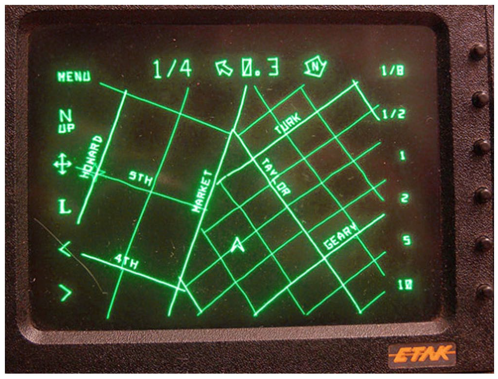
Vector-based CRT display of the ETAK Navigator (Edwards, 2015).
A disadvantage of dead reckoning was that the geomedia users always had to compare the displayed position on the map with the supposed position in physical space. As a consequence of this permanent personal evaluation and affirmation of their own place, users had to change the displayed cursor position by pressing adjustment knobs, not seldom while driving along a route.
Nevertheless, since the ETAK Navigator, “mobile egocentrism” (Sommer, 2002) has become a universal principle for all navigation devices, location-based services, and the construction of an augmented reality. What was crucial in the development of such geomedia technologies was the visualization through Gestalt transition, which was borrowed from Polynesian pre-modern mental navigation visualization and, therefore, from canoe navigation on sea (for a more detailed description, see Thielmann, 2008).
Instead of focusing on the movement of their own canoe, how it moves from one island to the next, a reference island was used (called an Etak) to bear at a star located above it. Throughout the trip, it appears as though the Etak is wandering from one star to the next, thus dividing the trip into discrete segments. The trip is, therefore, conceptualized as the movement of the surroundings and not of the canoe itself (Lewis, 1972). This figure-ground inversion was exploited by the entrepreneur and main inventor of the ETAK navigator, Stan Honey, and thereby introduced a transformation in the self-evidence of geomedia, to develop their functionality independently from centralized infrastructure (Hoban, 1985).
What is also crucial about all geomedia on water—or at least all geomedia that are surrounded by a fluid and unstable environment—is that they have to operate as a complete autonomous system and therefore one’s own movement is difficult to trace. The ETAK Navigator did not have a route calculation feature or GPS technology, but it could just estimate the current position by calculating the route with regard to a previously defined starting point. This even had the advantage of navigating without a displayed map (Figure 13), when—as often happened—a data cassette broke and was unable to read out with the magnet head of the tape drive (Edwards, 2015) or when the user forgot to change the map tape for the upcoming region and the system was therefore running out of a map.
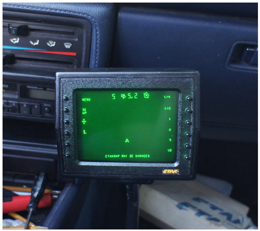
Revived ETAK Navigator in a Toyota Camry; insertion “ETAKMAP MAY BE DAMAGED” (own picture, 2012).
Movement on water or—with regard to the specific technical affordances of geomedia—also the movement across uncharted territories is thus characterized by the fact that the tracing of lines of becoming that have been passed along is essential both to determining one’s own position and to the infrastructural understanding of waterways and other embedded environments.
This allows us to establish a fundamental distinction between “tracking” and “tracing” based on the history of geomedia. Both media practices should not be equated to each other (Rogers, 2004). Tracking concerns the instantaneous recording of events, locations, or geopoints—whether and how these points are connected by a line is something that can only be decided subsequently. Instead, tracing refers to the subsequent reconstruction of a route, the more or less continuous tracing back of a path once taken. Tracking thus refers to instantaneous location monitoring and tracing to reconstruction that is undertaken ex post.
The two practices came together in the 20th century, once we were capable of continuously and instantaneously following our own movement, as was trialed in the bicycle mapping presented here, practiced using drift recording in aeroplanes or also realized through digital car navigation devices like the ETAK Navigator.
From a historical perspective, as demonstrated by the case studies, it was not digital technologies alone that resulted in a structural epistemological change in the capturing and representation of mobilized spaces. In the case of the ETAK Navigator, it was rather more the idea and conception of mapping and displaying the navigation with a car through the meshwork of streets, like the movement of a canoe on the ocean.
At the same time, it was important not to restrict the freedom of the street to ensure car navigation systems prevailed and became established. For example, the driver was still given the choice with the ETAK Navigator of finding the way through the cliffs of the “sea of streets.” Similar to navigation on sea, one was initially primarily preoccupied with finding one’s own position and recalibrating it manually, while the line of becoming remained within the vague and imaginary.
Nevertheless, in practice we are confronted with a perpetual oscillation between, on one hand, the manual production of the congruence and coherence of the first-person in situ perspective, and, on the other hand, the decision-making for a forthcoming track—which in this case is a virtual line of becoming, as the route was not displayed on the ETAK Navigator’s little tube monitor. In this way, geomedia have always been caught in double relationship.
Conclusion
Although “[i]t is not possible to read from the map the work of following the map in a way-finding journey,” viewed against the background of the lines of becoming of different geomedia discussed here, we can see that “[t]he traveller’s work of consulting the map is an unavoidable detail of lived, ongoingly, in-its-course, first time through, travelling body’s way-finding journey that the map is consulted to get done” (Garfinkel, 2002: 129).
Each of the traces of and as geomedia presented here renders the properties of the crossed environments visible, whether as curved or interrupted lines in the air, or as kinked lines on land, or as lines of separation when we are dealing with rivers. Looked at historically, geomedia take on a double perspective in this process. With regard to the movement in the air, this double mediality concerns a vertical perspective and, at the same time, horizontal path, a “view from both ‘nowhere’ and ‘now here’” (Kaplan, 2013: 34), and a capturing of movement over time and, at the same time, of a certain moment.
The double perspective on land is reflected in the fact that being awheel and making a territory accessible cartographically have been closely linked to each other from the very beginning of the geomedium “bicycle”; they take place in one and the same procedure as part of the joint practice of land surveys. Furthermore, the bicycle, as a vehicle that is connected to an individual, links the starting and end points of a route—without stops on the way and without changing vehicles. This continuity of movement is a highly essential property of geomedia as a means of transport and of environmental sensing. This specificity is also essential for the way the bicycle was used from the very beginning as tool to map unfamiliar terrain and at the same time as a platform for different measuring instruments.
The double mediality on water concerns the coincidence of tracking and tracing—location monitoring, on one hand, and the possibility of retracing a route, on the other, but also of understanding a line as a source and course in the case of rivers. However, this double mediality of visualizing local and at the same time universal knowledge is different from Latour’s immutable mobiles, as the different elements are difficult to reshuffle and to combine (Latour, 1990: 44 et seq.). The different layers have not the stability to be superimposable without frictions.
In all of the modes of movement illustrated in this article, the aim is to simultaneously establish how the paradox can be visualized, namely, that one is in a relatively stable position, while the surroundings are moving around us or are fluid. Once this paradox was visualized within the scope of a single first-person navigational perspective, which simultaneously makes one’s own location and the path that has been traversed visible, geomedia became an epistemological phenomenon per se.
From a praxeological point of view this multifaceted double perspective is crucial for media that exhibit their practices. Following Garfinkel (1996), we can argue that geomedia always exhibit a documentary and a procedural aspect. These two characteristics are chiasmically and inseparably linked with each over the history of geomedia. In their documentary form, geomedia can be recognized and described with the use of their characteristic scheme of diagrammed origins, passage events and destinations. In their procedural form, geomedia reveal their agency, which is, beyond others, their followability, only in situ in an actual case of being at a place and on the move and in a course of action at the same time. Similar to how Kitchin and Dodge (2007) have already postulated this for maps, we can demonstrate the following based on the mediated movement in the air, on land, and on water: geomedia are practices, spatial practices enacted to solve relational problems, such as how to get or how I got from A to B.
Based on Garfinkel (1996: 9 et seq.), we can argue that if geomedia are
read procedurally it makes unavoidable the map’s events in their local, unique territorial contingencies of gaze lines, perceptual aspects, perspectives, approaches, horizons, orientations, and directions. These present to the embodied work of the journeying local, territorial-specific contingencies of perceptual adumbration, and of preserving adumbrational coherence over the contingencies of looking at, looking for, of locating, and identifying in and as a material territory, an empirical territory, a phenomenal field of ordered details that is the oriented and directed route’s empirical territorial constituents.
In this sense, even the reductionistic traces discussed here inevitably make the constituents of the conditions in the air, on land and on water visible.
As the examples presented in this article have shown, the documentation of situations is deeply embedded in the understanding of geomedia, and this has not only been the case since the establishment of augmented reality applications or drone media and their imagery. Geomedia always gave support to in situ mobile media practices as they facilitate different first-person perspectives, (a) which became established when looking into the clouds or down to the ground from a balloon or aeroplane with the aid of the drift recorder, and (b) which manifest in a form of “tunnel vision” in bicycle mapping. Two straight parallel lines represented the road from the subjective perspective of the cyclist, while the relevant landmarks or parallel flow lines were noted on the left or right side of the sketch of the route in front of the handlebars, giving the impression that you were always on the right track. (c) The “mobile egocentrism” of digital car navigation displays perfected this in situ perspective.
This article has also demonstrated that there is a historical understanding of geomedia being instantaneous: it is never possible to have a simultaneous overview of the starting and end points of their traces and lines of becoming. The history of geomedia has shown that there is a continuous loss of knowledge in relation to an overview of the routes taken. At the start, with Baldwin (1786), it was still possible to see the starting and landing points on a single display—a hand-colored etching of a balloon prospectus in the first case discussed here. This complete information on the route has become successively reduced: initially to segments of the route, which only depicted the space perceived immediately beforehand and afterwards, through angular strokes that indicate the way that was/is to be taken, to a radical reduction of the route to a single point in the here and now. The history of geomedia is, therefore, also a history of the rise of selective seeing.
Geomedia thus reflect the infrastructural, environmental and practical conditions under which they come into being. Today’s geomedia amalgamate the three natural elements, air, land, and water, which were fundamental to the history of navigation. Without a differentiated historiography, this connectedness with natural things would not have become visible.
Footnotes
Funding
The author disclosed receipt of the following financial support for the research, authorship, and/or publication of this article: This work was funded by the Deutsche Forschungsgemeinschaft (DFG, German Research Foundation)—Project-ID 262513311—SFB 1187.
Author biography
 .
.