



Abstract
Natural resource extraction projects such as dams and mines entail alteration to or destruction of natural and cultural landscapes. Heritage mitigation efforts often propose compensating for or salvaging material heritage, largely because this can be inventoried and evaluated alongside economic and environmental resources. Intangible Cultural Heritage (ICH) is often overlooked, despite the fact that tangibles, intangibles, and economic resources together constitute the impacted landscape. Writing from the perspective of western Lesotho’s Metolong Dam, we view landscape as an embodiment of intangible heritage to explore what ‘landscape loss’ consequent on dam-building entails. We contend that this process involves dissociating intangibles from their material correlates, and transforming landscape experiences by dissolving and re-constituting boundaries and ‘resources’ in line with developer perspectives. We suggest that considering interdisciplinary approaches to landscape theorisation and ICH achieves a more nuanced view of how landscape loss and ICH interrelate, and thus improves mitigatory practice.
Introduction
Worldwide, but especially in Africa (Arthur et al., 2011; Hasfsaas-Tsakos, 2011; Näser and Kleinitz, 2011; Swanepoel and Schoeman, 2010), large-scale natural resource extraction projects such as dams and mines herald alteration to or destruction of landscapes, both natural and cultural. Developer-led mitigation efforts have traditionally addressed the loss of tangible entities (archaeological materials and economic resources) through salvage operations and/or financial compensation for impacted communities. In the case of heritage mitigation, rescue projects typically target material heritage and archaeology, omitting more intangible forms of heritage (e.g. oral histories and traditions 1 ) that, while difficult to define and inventory, are nonetheless constitutive of place and stand to be altered through development (but see Gavua and Apoh, 2010; Kleinitz and Näser, 2012; Nic Eoin and King, 2013).
Needless to say, these projects are fraught with well-documented problems:
Promises and potentials for financial compensation engender competition among stakeholders, wherein heritage emerges as a weapon as much as an asset (Appadurai, 2001; Hodder, 2008; King, 2011; Meskell, 2007, 2011; Robins and Van der Waal, 2008; Weiss, 2005); As development projects in Africa typically occur in communities that are under-resourced and under-represented, failures in communication between developers and stakeholders lead to feelings of helplessness (Devitt and Hitchcock, 2010; Hoover, 2001); and More broadly, as the ‘polluter pays’ (Organisation for Economic Cooperation and Development [OECD], 1975) contract mitigation framework is a ‘net zero’ one (i.e. focusing on a one-to-one replacement of resources lost), it is fundamentally incapable of accounting for the destruction of culture that cannot be replaced, evaluated, or, in the case of intangible culture, even adequately inventoried (Arazi, 2009; MacEachern, 2001).
Western Lesotho’s Metolong Dam (Figure 1) represents an endeavour to tackle these endemic problems of development schemes. The Metolong Dam and Water Supply Programme’s (MDWSP) Environmental and Social Impact Assessments (ESIAs) (SMEC, 2007, 2008) detail the planned mitigation for the dam’s impacts: they include financial compensation for loss of economic resources, constructing footbridges over the inundated river valley, job creation and capacity building related to construction, and a cultural resource management programme addressing physical and intangible heritage. Stemming from this last initiative, the Metolong Cultural Resource Management (MCRM) Project (Arthur and Mitchell, 2010; Mitchell and Arthur, 2010, 2012) began in 2008 under the direction of archaeologists from Oxford University. From 2008 to 2012, the MCRM Project enjoyed a substantial resource base and a broad mandate for large-scale archaeological survey and excavation, extensive community involvement, a four-year archaeological training programme (Arthur et al., 2011), and oral historical and archival studies (Gill and Nthoana, 2010). Additional fieldwork in 2011 and 2012 took place with support from Oxford University and the British Academy, and post-excavation analysis is ongoing. Additionally and unusually for many development projects in Africa, a pilot Intangible Cultural Heritage (ICH) study was conducted in 2010–2011 under the World Bank’s sponsorship (Monyane and Phafoli, 2011), and we carried out a follow-up study in 2012.
Location of the Metolong Catchment.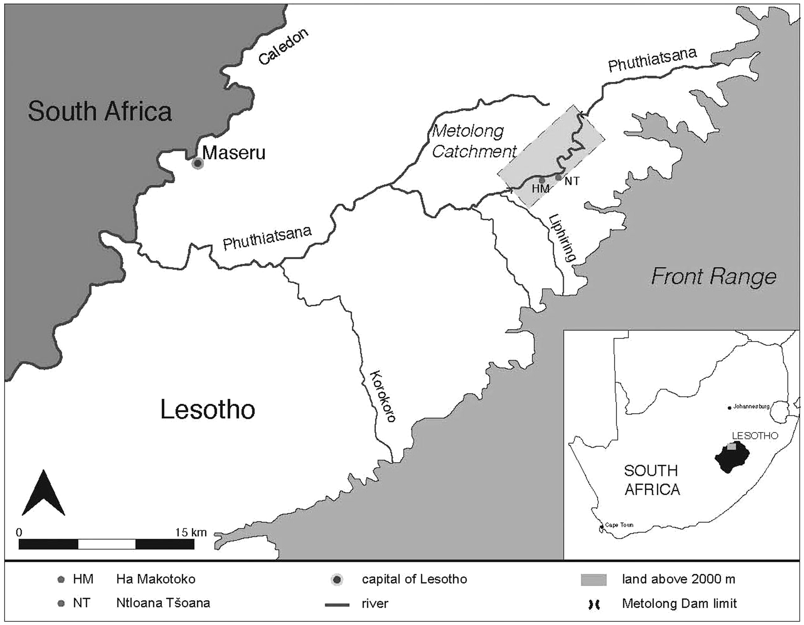
The Metolong Dam undoubtedly represents significant advances in cultural resource mitigation associated with large-scale development schemes, particularly as compared with previous dams in the Lesotho Highlands Water Project (separate from the MDWSP scheme, Mitchell, 2005). However, in revisiting heritage evaluations from the ESIA, the MCRM Project, and the ICH pilot, it is apparent that two major problems persist among stakeholders: (i) how to achieve workable, mutually-intelligible definitions of ‘intangible heritage’ and ‘landscape’ and (ii) how to translate these into practical mitigatory methods that reflect the needs and desires of impacted communities. Without adequate, useful conceptions of how landscapes are constructed and maintained, it is impossible to assess how they can be damaged or lost, and thence how to cope with or ameliorate that loss (cf. Nic Eoin and King, 2013).
Anthropologists are accustomed to viewing landscape as meaningfully, socially constituted, and fashioned from material and immaterial stuff alike (e.g. and at a foundational level, Bender, 1993; Mitchell, 2000; Tilley, 1994). However, these definitions of landscape often differ sharply from those implicit in developer-led mandates for mitigation, particularly in Africa (cf. MacEachern, 2010). As will become apparent here, cultural resource managers are often charged with partitioning landscapes into various types of culture, some of which can be saved or preserved, while others cannot. Either way, ‘landscape’ is dissected and mitigation efforts must either contend with these elements individually or attempt to piece them together again. Nowhere is this process clearer, we submit, than with the still-evolving field of ICH mitigation. ICH sits uncomfortably within the framework just described, as by definition it cannot be localised, quantified, or saved (see Nic Eoin and King, 2013 for discussion); yet ICH emerges as invaluable both in conceptualising the landscape that will be lost and in addressing the practices to mitigate this.
This paper contends that by integrating the concept of ‘landscape’ as understood archaeologically and anthropologically with ICH studies we can re-imagine developer-impacted landscapes, what their loss entails, and appropriate mitigatory practices. In considering various stakeholders’ (residents, heritage managers, developers) formulations of landscape and its transformation, it emerges that archaeologists, anthropologists, and cultural geographers have a vital role to play in formulating heritage management vocabulary; this is an area where terminology may have overwhelming influence on policy and its enactment. Far from semantic debate, we show that conceptualising the Metolong landscape in its anthropological sense highlights the inadequacies of current mitigation frameworks and may unite the perspectives of the different parties involved. Such an approach has major implications for heritage management policies, allowing heritage managers to address the impacts of large-scale development projects on material and living heritage.
The contention underpinning the following discussion is simple: landscape loss is not (as current development frameworks envision it) only about rendering resources unavailable or non-viable, but entails both substantively altering an entangled set of physical mnemonics, senses of place, and ecologies, and imposing new physical, social, and temporal boundaries. In that sense, it is not so much a calamitous process as a completely transformative (though nonetheless destructive) one, which mitigatory practices and policies must acknowledge.
In summary, this exploratory snapshot of a landscape threatened with imminent inundation (the dam is set to flood in mid-2014) draws on archaeological and ethnographic studies of the Metolong Catchment’s ICH and observations from the ESIA to highlight three salient points: (i) the dam’s construction will result in loss of material mnemonics for ICH, a fact especially apparent to us as ethnographers relying upon material cues in our interviews; (ii) paradoxically, the flood will be productive and destructive, creating physical barriers and, concomitantly, in situ refugees; and (iii) mis-alignment of developer, heritage manager, and community perspectives on economic, material, and intangible resources (and, indeed, the notion that these are separate entities) artificially partitions social and environmental ecologies, disenfranchising aspects of landscape that sit uneasily within this framework. Following these observations, we consider how landscape approaches to ICH should inform ICH assessment policy in large-scale development projects in Africa.
Introducing characters and stakeholders
The landscape
It is appropriate to introduce Metolong as place with the observation that ‘Metolong’ did not exist prior to the launch of the MDWSP in 2007. The Metolong Catchment is defined therein as a 14 km-long stretch of the Phuthiatsana River, located roughly 30 km east of Maseru, Lesotho’s capital. The 65 m-high dam and its associated Water Treatment Works are designed to supply water to lowland Lesotho. To archaeologists, the Catchment has been known as part of the Analysis Rock Art Lesotho survey conducted in the early 1980s (Smits, 1983), and subsequently as part of the Phuthiatsana-ea-Thaba Bosiu Basin since Peter Mitchell’s excavations there in 1989 (Mitchell, 1993, 1994; Mitchell and Steinberg, 1992; Mitchell and Vogel, 1992; Mitchell et al., 1994). For residents, villages in the Catchment fall under the jurisdiction of the principal chief either at Thaba Bosiu (roughly 9 km to the west) or at Berea (roughly 15 km to the northeast); these wide, amorphous boundaries will become significant later.
The developer
The MDWSP (and the larger Lesotho Lowlands Water Scheme of which it is a part) receives funding from assorted international donors (including the World Bank, European Union, and the Millennium Challenge Corporation). It is implemented by the Metolong Authority, an autonomous body with a Board of Directors appointed by the Government of Lesotho.
The ESIA
As a condition of funding, a comprehensive ESIA report was required prior to construction. SMEC International (Australia) in association with Southern Waters (South Africa) and FM associates (Lesotho) implemented the report, through deployment of three specialist teams (Environmental, Social, Instream Requirements). In fact, two reports were produced, both titled ‘final’, one in 2007 (SMEC, 2007) and one in 2008 (SMEC, 2008); only the latter is available online. There are some minor discrepancies between the two: in general, the 2008 version is slightly more sensitive to social issues (see Notes 2 and 3). The ESIA forms a central character in this study as it most clearly articulates the Developer’s vision (as opposed to the Resident’s, or the Heritage Manager’s) of what the Metolong landscape is, and how its loss may be mitigated.
The heritage managers
The MCRM Project received funding from the World Bank and the British Government, and was overseen by both the Metolong Authority and the Government of Lesotho’s Department of Culture. Despite serving as a consultancy, the MCRM Project was organised as a non-profit operation run through administrations at Oxford University (Phase 1) and St Hugh’s College of Oxford (Phases 2–4). Only field and laboratory staff received salaries, thus permitting long field seasons and an intensive training programme (Arthur et al., 2011: 238). Consequently, the project consisted of professional archaeologists, Basotho trainee archaeologists (several of whom are residents of the Catchment), specialists, and staff from the Morija Museum and Archives (Lesotho) and the National University of Lesotho.
Residents of Metolong
In the MDWSP, impacted communities are represented by community liaison officers, individuals from villages within the Catchment nominated by the village or appointed as consultants by the dam authorities. Officers facilitate community consultation, which occurs primarily through the traditional institution of pitsos (village-wide meetings), and communicate the outcomes to the dam authorities. Officers are also active in the financial compensation process: with the Metolong Authority, they identify resources representing consumable (i.e. quotidian) and durable economic loss (primarily agricultural fields and forests), the individuals or households to whom the losses accrue, and then dispense commensurate amounts of cash. Of course, local politics come into play: headmen, individuals and households have interests that conflict with those of the wider community, not to mention with the dam builders and heritage managers. We will return to these conflicts and problems of compensation.
Other actants (sensu Latour, 1996, 2004)
Present throughout the Metolong Dam operation is the array of ‘Good Things’ (bridges, roads, etc.), ‘Bad Things’ (noise, air, and trash pollution from construction, razor wire fences, the flood itself, etc.), and natural resources and consumables that are promised or accrue to residents of the Catchment during the dam-building process, all of which may lead to competition, debate, and tension.
Theories for a drowning landscape
In keeping with regional cultural resource management standards, the Metolong ESIA’s planned mitigation operations take the position that tangible heritage and environmental resources are discrete assets demanding separate solutions: either financial compensation, salvage, or preservation by record (although this latter is problematic, see below and Nic Eoin and King, 2013). While this approach is consistent with regional practice and is therefore the most feasible under current circumstances, we contend that it is also useful to explore views of landscape as a holistic, heterogeneous phenomenon with tangible expressions. Drawing on the rich theorisation of landscape in anthropology, archaeology, and cultural geography allows a different and, we suggest, more comprehensive idea of what the landscape of the Phuthiatsana is and does with respect to its inhabitants and other stakeholders to emerge. Following from this conceptualisation of Metolong, it then becomes possible to interrogate what landscape loss, or solastalgia, entails; this body of theory is more familiar in cultural geography than in archaeology but proves especially illuminating in this context. We focus on three conceits of prevailing landscape theories: (i) landscapes are networks of material and immaterial (memories, relationships, narratives, etc.) phenomena; (ii) the associations between these phenomena are the salient features of landscapes; and (iii) these connections have physical dimensions that manifest on the terrain itself. This last point has serious consequences for natural and cultural heritage management, and we direct attention to a handful of illustrative case studies.
Constituting and mapping landscape
Archaeological and anthropological studies show that landscape is produced through mutually constitutive relationships between place and people rather than simple occupation of one by the other (Bender, 1993; Mitchell, 2000; Sauer, 1925; Tilley, 1994). This meaningful constitution comes from those who live in the landscape, as illustrated by Heidegger’s (1997) definition of dwelling as conscious, lived engagement with the world. Moreover, landscapes (and, some might argue, the whole of the material world) are ‘meshworks’, entanglements of people, things, relationships, and memories that defy spatiotemporal constraint (Ingold, 2011: 63; Lefebvre, 1991: 117–118), and thus are constantly changing (Ingold, 2000: 199). While events or individual entities may coalesce around particular nodes, as in actor-network theory, the paths along which these entities interact with one another are the defining features of network rather than the entities themselves (Latour, 1999: 15).
While the paths of the meshwork differ in some ways from those of the network, in both instances they are the routes along which lives proceed and interconnect (Ingold, 2011: 148), and are inscribed by human actions and relationships (Ingold, 2000: 154). These processes imprint and intertwine themselves in physical space, thus creating places that occur as much as exist (Casey, 1996: 13). Relationships between people may therefore be embodied in place, as illustrated by Gow (1995: 47), and the terrain itself may thus act as a mnemonic for these relationships, which may not be between contemporaries (Bender, 1998: S106–S107): as they described the Catchment’s past inhabitants, residents of Metolong emphasised to us the exact locations where ancestors had lived and the physical remains of their dwellings (Figure 2). These mnemonics made the departed tangible and believable; remembering takes place through the materiality of these physical locales (Gell, 1998; Jones, 2006). If landscape is cultural (materially), then we must expect this: material culture is both memory-provoking and implacable in narrative (Lazzari, 2011: 174; Miller, 2008, 2010). By the same token, memory itself has a place: ‘Memory always will have a spatial frame (even if it is unremembered or latent)’ (Jones, 2005: 210). Attempting to capture these multi-faceted aspects of landscape has been a challenge for cultural resource managers worldwide; doing so on terrain foreign to archaeologists and in a manner that captures the emic perceptions of the landscape particular to its inhabitants is more challenging still (e.g. Colwell-Chanthaphonh and Ferguson, 2006).
‘M’e Maletlatsa Makotoko demonstrates how she uses her grandmother’s grindstone.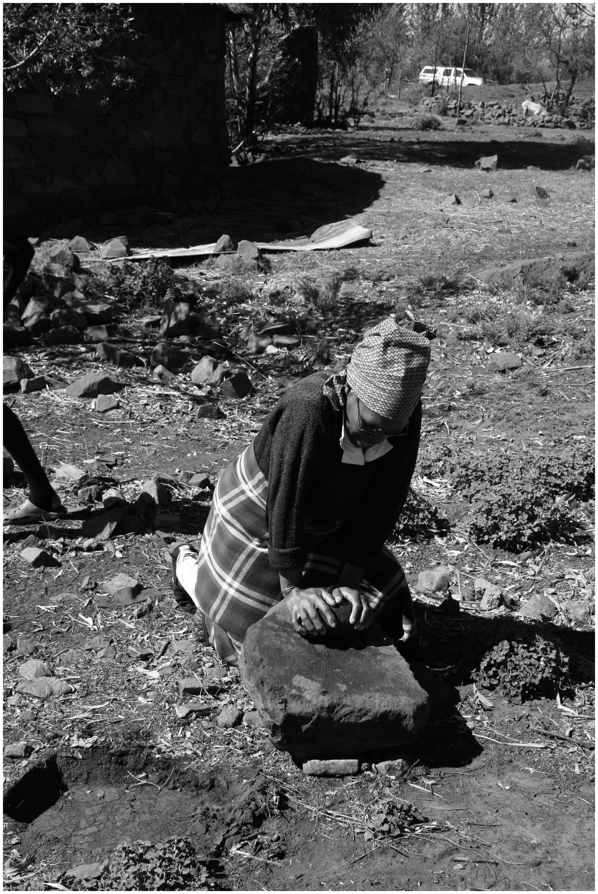
In part, this is to do with the difficulties inherent in translating landscape theory into practical measures for preservation, curation, and management (Nic Eoin and King, 2013). UNESCO proposes preserving ‘associative landscapes’ (Rössler, 2006) as a collection of linked tangible and intangible phenomena, but relies upon management guidelines that address these phenomena separately rather than as a holistic system (UNESCO, 2012: Section IIF; see discussion in Nic Eoin and King, 2013: 4–5). In contexts such as Australia, where the Burra Charter (Australia International Council of Monuments and Sites [ICOMOS], 1999) emphasises sense of place when preserving or mitigating landscape, this task becomes more feasible; unfortunately, without such legislation in place and no similar change to the culture of contract heritage management, countries such as Lesotho have little in the way of precedent, capacity, and regulation for such measures (Nic Eoin et al., 2013).
Nevertheless, attempts to capture indigenous conceptions and perceptions of landscape have been fruitful where they address intangible, mnemonic cultural elements mediated through physical locales. These ‘counter-mapping’ projects (Peluso, 1995) not only have the potential to reveal views of landscape that are perhaps latent or actively obscured (as with indigenous or minority political groups), but permit challenges to prevailing and even hegemonic perspectives (Byrne, 2008; Byrne and Nugent, 2004; Harrison, 2011; Thomas and Ross, 2013). Discussing counter-mapping from a joint natural/cultural heritage management perspective, Byrne (2008: 259–260) has noted the tendency for well-intentioned managers to treat natural and cultural landscape features as different layers of data. Conceptually, this can give the impression of distinct landscapes, one in which people may be left ‘off the map’ to foreground natural assets, and another in which archaeologically ‘distant traces’ of people are used to define landscape rather than contemporary culture (Byrne, 2008: 257, 260; see also Meskell, 2009; Tsing, 1993). Practically, one way of resolving this problem is to reject heritage sites as landscape constituents in favour of routes or itineraries (and their concomitant natural and intangible entanglements, Byrne, 2008: 260). Relating oral histories, practices, and mnemonics to specific (i.e. able to be given GPS coordinates) places and tracks addresses the physical elements of meshwork and network described above, identifying where people ‘sign the land’ (Bradley, 1997) and the land reciprocates in its inscription on individuals (cf. Wilson and Bruno, 2002). ‘Story-trekking’ is a particularly powerful means of identifying intersections of narrative and landscape (Green et al., 2003; Harrison, 2011), as following Langton (2002: 255), places are marked in part through kinship and story ties.
Where counter-mapping has been conducted in cultural resource management contexts, as with projects led by Byrne and Nugent (2004; Byrne, 2008), Harrison (2010, 2011), and Thomas and Ross (2013), to name just a few, practical emphasis has been on multimedia recording (photography, video, and audio recording) of intangible cultural forms (focusing on narratives and taskscapes) and linking these with geographical data. Undoubtedly this process helps archaeologists and landscape inhabitants alike to break down the distinction between sites and places (Prangnell et al., 2010) and affords an understanding of how the significance of place is open to change (Godwin and Weiner, 2006); this process enriches the practice of cultural resource management and fosters collaboration between managers and stakeholders (David et al., 2012).
Of course, these approaches and the entrenched problems of landscape and cultural visibility that they address are far from resolved, especially in terms of presenting data. Thomas and Ross (2013: 230) have observed that the result of counter-mapping projects is still a two- or possibly three-dimensional representation of a landscape described by fixed points, and a sense of dynamism is often lost in translation. Software programmes or multimedia exhibits present a possible solution for documentation and curation (e.g. Kenderdine, 2013; Thomas and Ross, 2013) where these can draw upon adequate infrastructure; however, they remain unfeasible in contexts such as Lesotho with minimal internet and electrical services and negligible personnel to facilitate these projects (see discussion in Nic Eoin et al., 2013).
There is another crucial point of divergence between existing counter-mapping studies and our work at Metolong: in the situations described above, heritage work was concerned with describing landscapes as embodying discourses of authenticity, struggle, and narrative (Byrne, 2007), and as evoking levels of temporality. While in some cases development schemes such as mines and powerlines may alter a landscape, the landscape as a whole will stand, perhaps in some ways amplified by the perceptible contrast between what has changed or decayed and what remains (Buchli and Lucas, 2001: 11), and the values attached to those extant but still mundane features (Miller, 1998: 130). In the case of Metolong, the landscape in question will largely disappear, and the project of documenting it and its intangible aspects takes on a new dimension: rather than addressing questions of, for example, authenticity and identity that have sedentary reference points, Metolong will lose its reference points.
Landscape loss
Given the social importance of landscape, it follows that its removal or alteration may result in emotional turmoil for those who dwell in it. While landscape loss is a topic of current (and indeed established) debate in cultural geography, it has made less impact as yet in archaeology (although see Thomas, 2001: 172). However, the concepts therein lead seamlessly on, and indeed support the central tenets of, archaeological landscape theory. As we will discuss, the idea of landscape loss is especially germane to salvage heritage work.
Human attachment to place, or topophilia (Tuan, 1974), is such that the language used to discuss it is necessarily emotive. Scholarly explorations of ‘emotional geography’ contend that social and sensory relations define landscapes (Kearney, 2009: 211), involving emotional, spiritual, and intellectual dimensions that outsider anthropologists can comprehend only partially (Dallman et al., 2013: 35). Nowhere is this more evident than when landscape is threatened. Porteous (1989) places the loss of landscape within Kübler-Ross’ (1973) framework of grief over the death of an individual. Albrecht (2005, 2010: 227) describes solastalgia as a psychological, clinical experience, describing it as ‘the pain or sickness caused by the ongoing loss of solace and the sense of desolation connected to the present state of one’s home and territory.’ There is an existential component to this process: as places become ‘thinned out’ or non-existent, so too do identities rooted therein (Casey, 2001: 686–687; Tschakert and Tutu, 2010; Tschakert et al., 2013: 15; see also Davidson et al., 2005; Ryan, 2013). The idea that places are necessarily emotional is well-established in human geography, and underpins fields such as ecopsychology and environmental memory.
Metolong falls within this context: relationships negotiated through and within the landscape of the Phuthiatsana will change inexorably as the landscape itself changes. The emotions documented here – frustration, sorrow, dissatisfaction, helplessness, anger – are common in the context of landscape loss, and understandable when landscape is understood as social. However, Metolong is very different from hegemonic landscape projects, in which physical entities are removed or appropriated to naturalise authority (Hobsbawm and Ranger, 1983; Ireland and Lydon, 2005; Lazzari, 2011), and from landscape deconstruction (cf. Meskell, 2002). Porteous (1989: 227) notes that spectacular efforts at ‘place annihilation’ (e.g. the bombing of Dresden) or deconstruction are not as effective as they may initially appear, as traces of place may remain. Landscape can evoke memory (and forgetting) when some physical ‘details’ (DeCerteau, 1984: 87–89) are removed (cf. Küchler, 1999: 62–64); indeed, institutional forgetting may be more of a problem than inhabitants’ forgetting (Rico, 2008).
At Metolong, on the other hand, we are confronted with a drowning, vanishing landscape. Swathes of the palimpsest of Metolong will be lost, including its inherent materialised, synchronic attributes and potential future associations. Our contention that landscape loss is a process more akin to dis-incorporation and transformation than annihilation draws on these assertions: Metolong’s inundation will not obliterate identities rooted in memory and place, but will re-locate and re-figure them; the paradox is that this will occur without demographic resettlement. Similar to the ways in which diasporic communities often identify and empathise with unseen or imagined places (Basu, 2005; Lilley, 2006; Russell, 2012), flooding the Phuthiatsana will force residents to re-locate their sense of place while physically staying put. The construction of value in features ‘surviving’ landscape loss becomes significant below.
Methods: The ICH assessment
While some ICH work has been carried out in Lesotho to date – indeed, Lesotho was the location for a series of UNESCO capacity-building workshops on inventorying ICH in 2010 (Keitumetse, 2012; cf. Labadi, 2013; Lekoekoe, 2010) – our study built on an original pilot ICH assessment of the Metolong Catchment specifically directed at elements endangered by the dam’s construction (Monyane and Phafoli, 2011). While this study recorded mundane and ritual traditions (beer brewing, boys’ and girls’ initiation rites, etc.), it failed to address those intangibles that might be changed through the valley’s inundation as their material correlates stood to be altered or destroyed. That these material correlates are inextricably linked with ICH (in the form of stories, history, and lived daily practices) will become evident below. This position is arguably at odds with the UNESCO definition of ICH (UNESCO, 2003, although see Note 1 for comment on ambiguity therein). For further discussion of this and the practicalities of implementing ICH safeguarding in a landscape/development context (with special attention to the problems of preservation by record), see Nic Eoin and King (2013).
Drawing on previous examples of counter-mapping projects (albeit on a much more limited scale), our 2012 research sought the material correlates of the Catchment’s intangible components; this was a necessary heuristic device and we recognise that these interrelationships do not always exist in one-to-one correspondence (cf. Bradley, 2008). In large part, we draw on examples of wayfaring and ‘story-trekking’ described above, and follow Massey (2005: 183) in viewing physical expressions of narrative and mnemonic as ‘simultaneit[ies] of stories-so-far.’ In September 2012, we held discussions with residents of six villages, with the help of ‘M’e Matikoe Matsoso and ‘M’e Pulane Nthunya, our interpreters and both graduates of the Metolong archaeological training programme. Our discussions were shaped by our individual research interests (economic botany [Nic Eoin] and historical archaeology [King]), and by the experience of one of us (King) living and working in the area for over two years.
Specifically, our remit was a form of preservation by record (discussed below). We documented interviews using written notes, video and audio recordings, and photography. Our methodology includes analysis of these notes and recordings, further discussion and successive interviews with residents as to their wishes for the future, and mapping impacted landscape features and their related social meanings.
Landscape loss in real time
Disappearances; or, can the intangible vanish?
Residents of the Metolong Catchment use the valley for a number of activities and to extract a variety of resources. These include riverine resources such as reeds for thatching roofs, sand, and rocks for building and as constituents of traditional medicines, raw materials for grindstones (medicinal and culinary), and, of course, fish. Along the river, people hunt small game and gather medicinal and food plants, animal fodder, and firewood. All of these (and certainly others that we have failed to capture) will be imperiled or lost altogether when the dam is built.
To its credit, a Metolong ESIA acknowledges the significance of both quotidian (wild foods for subsistence, firewood, construction materials, etc.) and durable resources (i.e. representing future economic returns) (SMEC, 2008: Article 6.3.3.1). As mentioned above, the ICH pilot study similarly recognised the role of everyday practice in constituting a landscape. Therefore, investigating the physical nodes at which intangible and material elements intersect revealed the importance of locales such as river-crossings, communal washing and swimming spots, baptismal pools, rockshelters with historical attachments and/or uses for traditional healing, and favoured patches of medicinal plants (Figure 3).
Map of physical mnemonics and significant places identified by residents in the Metolong Catchment. Locations are labelled as follows: (a) rockshelters where children play house; (b) Mangoede, a stone named for the tallest man in Ha Makotoko and used to measure river height; (c) shelters used for girls’ initiation schools; (d) gardens used by healers; (e, f) locations used by Zionist Church for baptisms; FTP Fateng Tsa Phollo, rockshelter used to prepare medicine; HM Ha Makotoko, rockshelter whose local name comes from a San inhabitant, Qebeletshane; NT Ntloana Tšoana, rockshelter used for protective magic during the Gun War (1880–1881).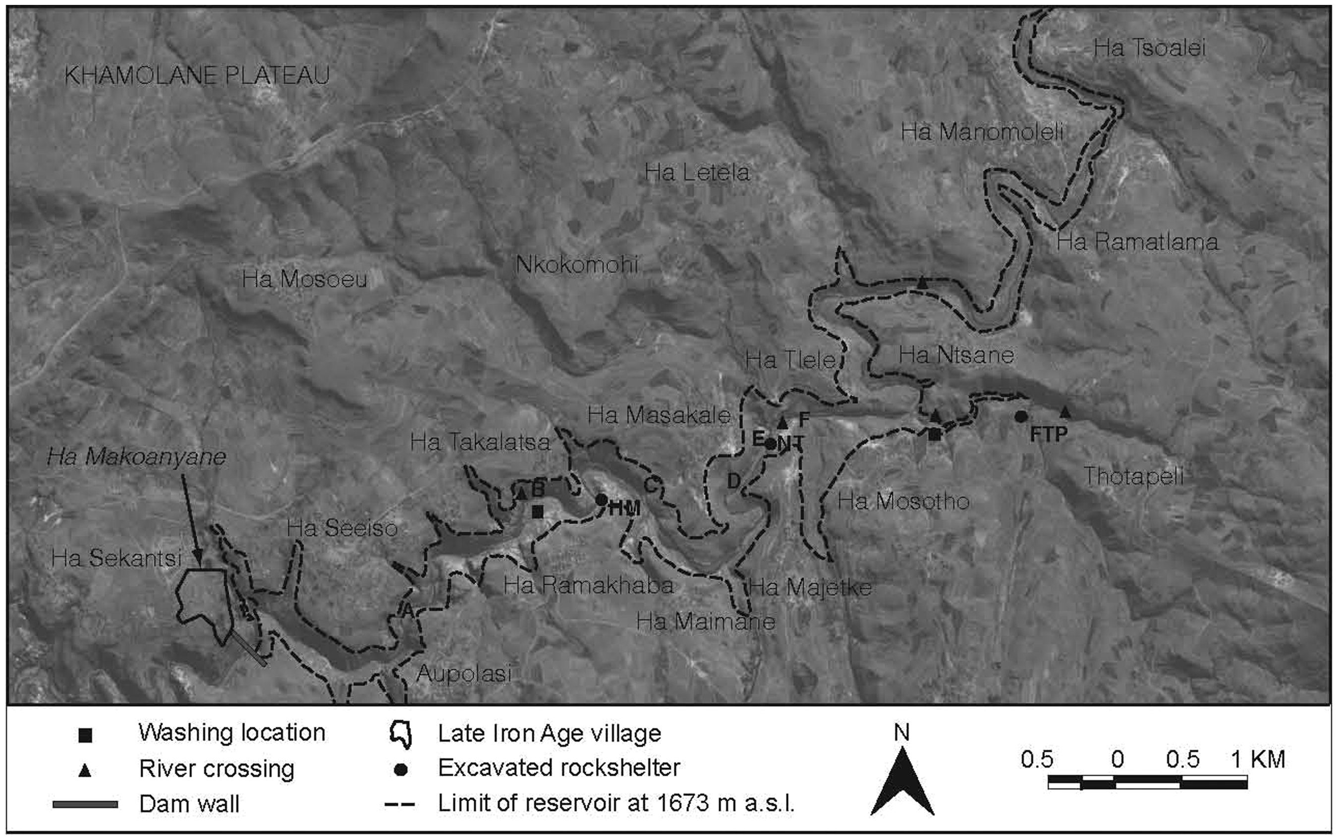
As described above, daily uses and attachments to place (as much as exceptional, localised events) constitute a landscape (Heidegger, 1997; Ingold, 2000: Chapter 10; Tuan, 1974); this is both a theoretical contention and a reality for Catchment residents. Consistently, interviewees were anxious that losing these physical entities will entail losing the ability to communicate knowledge and history without material cues, both within and among villages and, perhaps more importantly, to future generations. The months leading up to the Catchment’s inundation (likely to be completed in mid-2014) are already witnessing the beginning of a disjuncture between ante- and post-diluvial generations: those who remember and mourn the loss of landscape features, and those who will receive stories and traditions without tangible, visitable correlates.
Ntate Michael Maqokela, a 73-year-old lifelong resident of Ha Masakale, aptly expressed this concern over the loss of Metolong’s mnemonic landscape. Ntate Maqokela is particularly worried about the drowning of Lehaha la Ntloana Tšoana (‘Dark House Shelter’), one of the two rockshelters excavated intensively during the MCRM Project (Arthur and Mitchell, 2010; Mitchell, 1993; Mitchell and Arthur, 2012; Mitchell and Steinberg, 1992) and located within Ha Masakale’s jurisdiction. Ntloana Tšoana figures prominently in Ha Masakale’s founding: during the Gun War of 1880–1881 (Eldredge, 2007; Gill, 1993: 133–135; Sanders, 2011), the region’s principal chief sent Masakale, a renowned healer able to communicate with ancestors, to the shelter to exercise his magic and thus protect people in the valley from violence. Masakale mixed the components of his magic in the naturally-occurring cupules in the sandstone at the front of the shelter (Figure 4) and, thanks to his efforts, residents of the Phuthiatsana Valley were spared the worst of the war’s depredations. With the valley thus secured, Masakale established the village of Ha Masakale atop the gorge, which his descendants govern today.
Nate Michael Maqokela describes how Ntloana Tšoana was used for making protective magic in the 1880s.
Ntate Maqokela believes that relating the history of the village and of those who once lived along the Phuthiatsana will be impossible once Ntloana Tšoana disappears, especially for younger people who will have no first-hand experience of the shelter. What is more, he maintains that archaeological investigations have already created a schism between generations. When excavations began at Ntloana Tšoana in 2008, layers of culturally sterile river silt overlay the archaeological deposit by as much as 1.8 m in some places. In order to excavate, archaeologists had to remove this overburden across the majority of the site, lowering the shelter’s floor, expanding the vertical space within the shelter and allowing in more light. Consequently, Ntate Maqokela maintains that archaeologists are personally responsible for rendering the name of the site dissonant with the current experience of it: villagers have witnessed the dismantling of the ‘Dark House’ and very young children never knew it in its previous state.
Ntloana Tšoana demonstrates that we are not dealing with monuments whose loss can be mitigated or preserved by record, but rather with an entangled set of mnemonics and experiences that, as Gow (1995) reminds us, are actively involved in mediating contemporary social relationships and constituting social history. This applies equally to historically significant places such as Ntloana Tšoana and to more prosaic places like Mangoede, a river stone named for the tallest man in the village of Ha Makotoko and used to measure river height, thus serving as a barometer of safe crossing. Further, as ethnographers and archaeologists in conversation with Catchment residents, we consistently refer and are referred to the landscape to illustrate a point, tell a story, or demonstrate a practice. These material cognates serve as crucial cultural and narrative mediators in our relationships with interviewees, and their loss raises concerns for future oral historical and ethnographic study.
Landscape transformations
If landscape is not static but rather continually in the process of becoming, then to talk of landscape loss is also to talk of landscape change. It is tempting to think of flooding related to dam construction as a purely subtractive process: topographically, a major part of the valley will become inaccessible and, following the prevailing logic of developers and dam opponents alike, will be excised from the Catchment. However, inundation creates new places while overwriting old ones: a feature of dam construction that has been almost entirely overlooked is how inundation will augment or re-locate aspects of the landscape, and the effects that these will have on Catchment residents.
In addition to the dam wall itself, the Metolong Authority has constructed several footbridges across the Phuthiatsana River and major feeder roads serving a handful of villages. Many residents of the Catchment and of outlying areas see the benefits of these features: roads will facilitate travelling and transporting goods within the Catchment and to and from Maseru. These projects stimulate the growth of local small businesses such as cafes and stores. For those living farther afield and needing to cross the river, footbridges will cut hours of strenuous walking from a journey. However, embedded in these compensatory schemes is a mis-characterisation of the existing Metolong landscape and the social relationships inherent therein; consequent on this is imposing new territories and changing old ones, as well as dividing or re-structuring relationships among people, families, and villages.
The footbridges are a useful place to begin examining this proposition. Catchment residents generally agree that footbridges are ‘Good Things’, for the reasons outlined above. However, footbridges illustrate a new concept that the dam will create: the Phuthiatsana River as barrier. The 2007 ESIA
2
explicitly takes this position (SMEC, 2007: Article 6.6.3.2.8), which runs contrary to the views of most residents: to them, the river is more a resource base and a socially important entity than a barrier (except when water levels are exceptionally high). This became clear when residents described where the political boundaries of (ante-diluvial) villages lie. Figure 5 shows that village limits do not always follow the river but in some cases transgress it: by virtue of its connection to Ntloana Tšoana, Ha Masakale claims territories across the Phuthiatsana (claims that the Metolong Authority recognised in its financial compensation for loss of forest resources): and since Ha Makotoko identifies several ‘descendant villages’ (i.e. villages whose founders re-settled further afield but claim origins in Ha Makotoko) on the Khamolane Plateau and almost into the Front Range of the Maloti Mountains, it claims these as its boundaries.
The Metolong Catchment with some political boundaries as they relate to the Phuthiatsana River.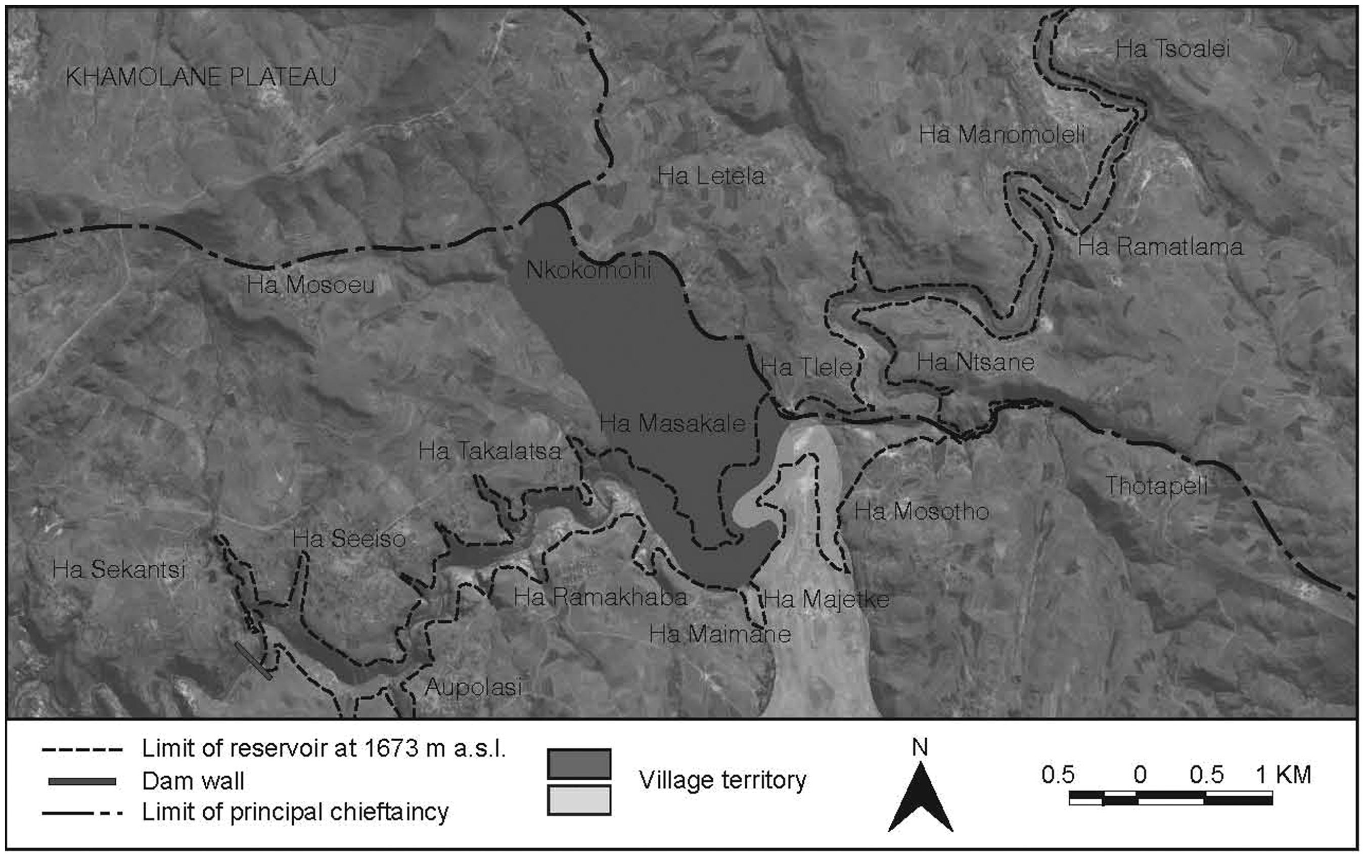
On a smaller scale, river crossings (Figure 3) enable almost constant connection between the north and south sides of the Phuthiatsana. For example, ‘M’e Maletlatsa Makotoko was born in Ha Seeiso on the north side of the river, where her mother, ‘M’e Bela Nthunya, and other members of her family still live. When she married, ‘M’e Makotoko moved to Ha Makotoko on the south side but, because of one well-known crossing point directly below her home, she visits her family multiple times a week. When the valley is flooded, this crossing will be lost and to visit her mother, ‘M’e Makotoko will have to walk farther out of her way to one of the footbridges, which she predicts will make her visits less frequent.
This idea of the Phuthiatsana River as a barrier is a construct of developers, but will become the sole reality for the Catchment’s residents once the dam is built. It underscores the point that, while the Metolong Dam undoubtedly represents an improvement on earlier policies associated with dam-building in Lesotho (Thabane, 2000) in that communities are not being resettled, parts of the Metolong area will disappear instead. River crossings will be restricted to footbridges, whereas before people were free to find their own paths. Importantly, these bridges do not support animal crossing, which will impact the use of grazing lands on either side of the river (the 2007 ESIA views this as a ‘Good Thing’, as these riverbanks are eroding due to over-grazing and the number of animals grazed should therefore be reduced accordingly, SMEC, 2007: Article 6.1.2.33). Already, residents are planning new routes across the river, building gardens to curate plants that will become inaccessible once the valley is flooded, making arrangements with other chiefs for using grazing lands (often at least a day’s walk away), and selecting new rockshelters outside the Catchment for medicinal and ritual use. Accompanying these changes (as well as the ‘Good Things’) are social problems: residents worry that the influx of construction teams in the area may exacerbate local AIDS rates, create a demand for sex workers, and break up existing family units (cf. Hoover, 2001).
Thus, the landscape is, in a sense, being forced to re-locate and people are effectively becoming in situ refugees. Inasmuch as communities’ identifications and self-identifications are rooted in the places and spaces that constitute a landscape (Malkki, 1992), we can see these roots being displaced as the landscape is transformed. This is not to suggest that Catchment residents are heavily territorialised or essentialised; here, ‘refugee’ is not an inflammatory term, but one evocative of forced movement. These observations flatly contradict the developer-led notion that a corollary of avoiding population resettlement is population stasis: it belies a basic misunderstanding of relationships among people and places, and of how diverse stakeholders perceive these.
Valuing and mitigating ecologies
As noted earlier, mitigation efforts associated with development projects account for landscape loss according to economic criteria: resources (consumables) with economic value are identified for compensation, while cultural heritage is salvaged or preserved by record. This process arbitrarily severs the natural and social ecologies encompassing economic, material cultural, and intangible assets, and re-constitutes them according to developer-led perspectives. Thus, we see fissures form in the landscape, based on the values of what will be lost (or saved), with immaterial features that may be recorded but not valued falling between the cracks.
As mentioned above, the Metolong ESIA provides remuneration for loss of durable resources. While generous, this is often ahistorical and overlooks the social context of these resources (Scudder, 2005: 129–132). For example, the 2007 ESIA suggests (SMEC, 2007: Article 6.6.1.1.2) that offering payment for reducing the amount of viable grazing land (and thus the number of cattle) in the Catchment mitigates erosion. This overlooks the fact that in Basotho society cattle have numerous socially-embedded meanings (power, prestige, etc.) and are not freely inter-convertible with cash (Ferguson, 1990: 124) 3 .
In terms of loss of cultural material, the mitigatory tools available are salvage and preservation by record. Salvage has specifically material applications and connotations: objects can be saved while more amorphous forms of heritage like intangibles and oral histories can only be documented, and even then to a limited degree. The notion that some heritage can be rescued (the physical) while some cannot (the non-physical) introduces a schism, even a tension, between extant and defunct heritage: some is worth rescuing while the rest is not. This is similar to the logic behind resource compensation, and some sense of the durable resource inheres in material heritage. The innate quality of materials deserving to be rescued, indeed the fact that they survived at all, bestows a sense of value and significance (Lafrenz Samuels, 2008; Weiner, 1992) that preservation by record cannot.
Nevertheless, preservation by record appears best-suited (or least-badly-suited) to the nascent concept of ICH assessement. While ICH has been extensively debated in academic circles, translating these debates into actionable measures within a contract framework and in a manner sensitive to their particular contexts has proven challenging, especially in a country like Lesotho, for several reasons (Nic Eoin and King, 2013).
First, the lack of a workable framework for ICH evaluation means that ICH assets are inventoried alongside tangible and economic resources (as outlined above, see Kurin, 2004: 72). The result is a tabulation of the intangible as a set of discrete (although at times cross-referenced) elements that appear to exist relatively independent of one another and also of other cultural and environmental resources; imagine a large spreadsheet with each asset as a line item and the difficulties inherent in producing and understanding this. Despite the laudable efforts toward building capacity for ICH recording that UNESCO has made in Lesotho, it is our view that the explicit emphasis on inventorying (Lekoekoe, 2010) makes this framework unsuitable for use in the context of a landscape at risk. Second, the curatorial obligations entailed in preservation by record have been insufficiently problematised (Brown, 2005; Kraemer, 2010): how are oral historical and intangible heritage studies to be made available to dam-impacted communities? Elsewhere (Nic Eoin and King, 2013) we discuss the ramifications of this in the context of Metolong, but here we emphasise that the currently proposed presentation of tangible (salvaged) heritage to the public and omission of the intangible (recorded) component drives home the value discrepancy discussed earlier. Further, it neglects a component of the Metolong landscape that, as we have demonstrated, is actually part and parcel of its material attributes.
At this point, different valuations of the landscape’s material aspects have made it easy to lose sight of how the intangible and the physical, natural, and cultural are interconnected. To its credit, the Metolong Authority recognised these connections when it modified its plans for constructing a road and housing project in order to preserve Ha Makoanyane, a late nineteenth-century abandoned village, based on its material and immaterial (historic) attributes. On the other hand, artificially splitting landscape ecologies and their values creates rifts in which communities can get lost. The case of the village of Ha Ntsane illustrates this: Ha Ntsane is losing fewer durable resources than other villages and therefore receiving less compensation; footbridges are several kilometres away, making travel across the river more challenging than helpful; and while the village boasted few excavatable archaeological resources, a rock art panel (Mallen, 2010: 16–17) was deemed significant enough to remove as part of the MCRM Project in 2012. Follow-up consultation revealed that Ha Ntsane residents feel slighted by the compensation/mitigation scheme: they receive less money than their neighbours, do not benefit directly from the ‘Good Things’ installed, and their only cultural asset deemed worthy of salvage was excised, albeit with the promise of installation in a heritage centre at the dam site.
Thus, we see the processes of inventory creation, valuation, compensation, and mitigation as responsible for dis-incorporating the Metolong landscape. Immaterial aspects fall largely in a ‘nexus of neglect’ (Byrne, 2002: 140) because of the difficulty in placing a value upon them, and, while their significance is undeniable, their nature precludes salvage and favours preservation by record. Of course, anchoring intangible heritage in material features translates the immaterial into something that more readily fits within the mitigation framework, and was the logic behind our adopting the approach presented here. However, this does not resolve the core dilemmas around valuing and evaluating landscapes.
It is important to emphasise that the problem here is not necessarily a discrepant valuing of nature versus culture, nor that the process outlined above entails fetishising these features (Meskell, 2011: 21–26, 116–121). Rather, we describe an operation that dislodges an understanding of landscape as encompassing, socially constituted, and meaningful, and obscures interrelationships among materials and phenomena. Landscape assets are then re-assembled along the lines laid out by the dam-builder (returning to the image of the spreadsheet), producing new ecologies that reflect the developer’s needs more than those of heritage managers or community stakeholders.
Conclusion: Whither Metolong?
We can now articulate what constitutes the Metolong landscape and what loss of this ante-diluvial landscape entails. Prior to the Metolong Dam, the area now called Metolong was sacral, economic, and a place of dwelling. After the dam is built, its current significations, manifested as a palimpsest of different narratives and knowledges embodied in place, will be over-written with a new significance: Metolong as dam. Metolong as hunter-gatherer landscape, location of rock art, resource base of plants and animals, grazing and shelter for animals, swimming and baptismal places, crossing points and children’s playground, hunting ground and home to ancestral figures, village founders and today’s residents – all of these meanings will fade and it will become increasingly difficult for residents to narrate their pre-diluvial lives once the relevant material cognates have gone. Their relationship with the landscape will change as the landscape itself changes: this will not figure solely as loss and hopefully residents will eventually benefit from the ‘Good Things’, but the process will be dramatic.
We argue that projects seeking to mitigate loss associated with large-scale development projects can be more successful if their efforts are directed towards landscapes holistically rather than select elements. This entails sufficiently and usefully theorising concepts such as landscape, salvage, and preservation, and ensuring to the best of our abilities that stakeholder perspectives align with regard to these ideas. As we have observed elsewhere, establishing workable definitions of intangible heritage and guidelines for its assessment in mitigation contexts (Nic Eoin and King, 2013), as well as problematising concomitant curatorial needs and obligations (Nic Eoin et al., 2013), must occur if cultural resource management associated with landscape loss is to improve. Drawing on approaches from related disciplines such as human geography can also prove fruitful, particularly applying concepts such as topophilia and solastalgia to landscape loss due to natural disasters, anthropogenic destruction, and diaspora. Our discussion here has demonstrated that the theories and vocabularies that we as heritage managers employ bear directly on mitigation policy and operations: developers cannot provide adequate compensation for an entity which is not fully understood, and, as we demonstrate here, resort instead to valuation of landscape in attempt to deliver some form of compromise.
Metolong is a somewhat unusual case, especially for Africa, as developer desires for a holistic mitigation operation largely resonated with our own; despite the need to break down heritage assets into the tangible and the intangible, the fact that an ICH assessment was included at all (let alone two assessments) makes the MCRM Project unique and enriched the Project as a whole. However, this model may not be workable in all situations: affected areas that are linear (pipelines, for example) and less compact than Metolong require different strategies, and many projects may simply lack the budget for an ICH component. ICH assessment in development is not common practice in Africa and, unlike in other global contexts, there is little legislative incentive in most African countries for it to become so.
In Lesotho this is especially worrying given the proliferation of dams that has already begun and will continue to a total of at least five large dams under the aegis of the Lesotho Highlands Water Project. When the contract for the environmental impact assessment ahead of the next Highlands Water dam at Polihali went to tender in 2012, the stipulations for heritage impact assessment considered only material archaeological sites, failed to mention ICH, and did not account for the interconnectedness of natural and cultural heritage. Failing proactive moves by the eventual heritage managers and developers later in the mitigation process, this will remain the dominant framework for heritage management. If landscape, landscape loss, and management thereof proceed with the view of heritage as a set of partible objects occupying space in an impacted area, rather than the meshwork view we have described, mitigation will no doubt proceed in a similarly patchwork and ultimately unsatisfying fashion. Where the result of failure to adequately conceive the heritage at stake is trauma on the part of landscape inhabitants and irreplaceable loss, there is a particular imperative to ensure that mitigatory practices are informed by accurate perceptions of landscape and heritage on the part of all stakeholders. From the perspective of heritage managers in contexts such as Lesotho, where legislation is unlikely to reform in the near future, our obligations begin with usefully applying anthropological concepts such as landscape and ICH in our work.
Footnotes
Acknowledgements
We thank the following people for their help during this research: Steve Gill, ‘M’e Maletlatsa Makotoko, Ntate Michael Maqokela, ‘M’e Matikoe Matsoso, Ntate Bolaee Molise, ‘M’e Bela Nthunya, ‘M’e Pulane Nthunya, and the Thorn family. Thanks especially to Charles Arthur and Peter Mitchell for their support and encouragement, and to Lynn Meskell for her help during the editorial process. We also thank reviewers for their comments. We are grateful to the Metolong Authority (particularly to Melissa Moffett) and the World Bank for their ongoing support of the MCRM Project and all its components. This research received additional funding from the Tweedie Exploration Fellowship for Students from the University of Edinburgh, the University of Oxford’s School of Archaeology, St Hugh’s College, and a Clarendon Scholarship from the University of Oxford.