




Abstract
The visual imaginary of the future city is increasingly dichotomized between visions of hyper-technological digital urbanism and the city in a state of ruin, without people, overtaken by nature. These alternating imaginaries key into concerns over urban futures, as questions of sustainability and rising inequality come to bear on urban life. Such binary imaginaries produce volumes of visual material, lauding and critiquing philosophies of newness, endless progress and the city without decline. This article uses an inventive visual methodology to ask how these imaginaries become situated in the everyday ecologies of living. This methodology focuses on several so-called ‘brownfield’ sites in Salford, UK, and the ‘smart’ Oxford Road Corridor in neighbouring Manchester, to playfully and visually map the entanglement of digital urban ecologies through the themes of wilderness, play and compost. These three themes relate to the pleasure of urban wilderness described by Rose Macaulay, reflecting on London’s wild ruins after the Second World War; the playful contrast between smart urbanism and urban wastelands, understood through interdisciplinary visual methods; and Haraway’s notion of compost as the fertile ground of collaboration that marks a material–semiotic entanglement between place, people and nature. The authors investigate how these frameworks reflect the diversity of urban ecology (animals, plants and humans) and might provide an alternative vision of how the city could be, a vision built from how the city currently is.
Introduction
Manchester and Salford, in the UK – twin cities on either side of the River Irwell – are often cited as the world’s first modern, industrial cities (Davies and Fielding, 1992; Wyke et al., 2018). During the Industrial Revolution, both became centres for industrial productivity, and the construction of the Bridgewater Canal (see Figure 1) in 1761 marked the commencement of the canal era in Britain and the industrial era in Manchester. After the Second World War, Manchester and Salford were impacted by mass deindustrialization, burdened with the remnant pollutants of industry in the air, soil and water; brown-fields and industrial relics were unattractive sites to remediate in a shrinking economy. In this partially abandoned landscape, new ecologies flourished; what were once centres of growth became edgelands and spaces of ‘boundary work’, between ruins and wilderness (DeSilvey, 2017: 129–153).
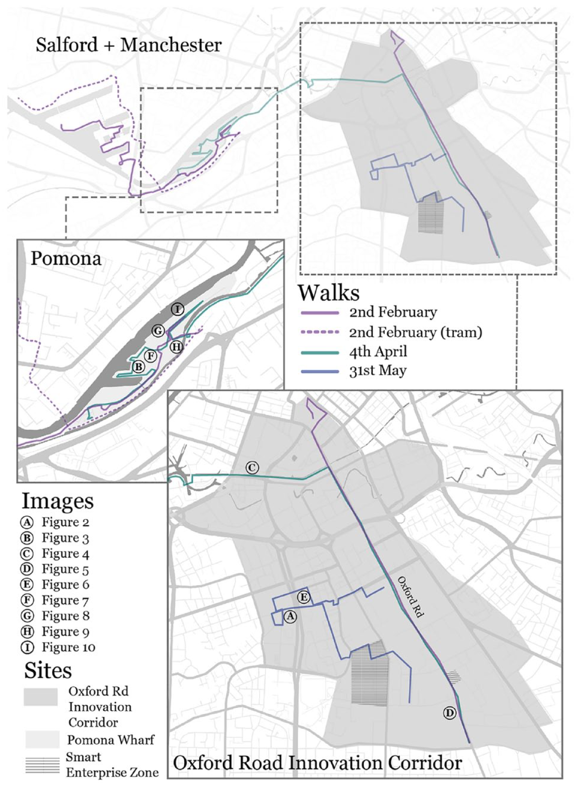
Mapping relations. The distinctions between the geography of the Oxford Road Corridor and the designation of an Innovation District or Innovation Corridor are unclear. In some sources, the ‘district’ expands on an existing area of health and science innovation adjacent to Oxford Road; in others, ‘Corridor Manchester’ is a wider commercial zone dedicated to innovation and enterprise. A tech-focused initiative by the University of Manchester (2019) is also referred to as Innovation District Manchester, or ‘I.D’ (see sources from Deloitte, 2018; I.D Manchester and Oxford Road Corridor, 2015, 2019, nd(a), nd (b)). With the inclusion of local HEIs, the boundaries stretch as far as UoM’s North Campus and Manchester Metropolitan’s Campus to the West (hereafter MMU). This larger zone has been used to develop these maps of what we term the Innovation Corridor.
In Manchester and Salford in 2019, regeneration is almost complete. Zones designated for cultural and technological innovation stand amidst (but almost entirely separate from) just a few wild and unkempt wastelands and abandoned sites, equally divided from local communities, who do not feature in innovation-focused imaginaries, and producing spaces of uneven development (Smith, 2010; Fraser, 2018). Salford’s Media City (hosting the BBC and other major media organizations) and Manchester’s ‘Oxford Road Corridor’ for innovation (a tech-focused area designated in 2015 (Oxford Road Corridor, 2015)) are particular sites of contrast. Here there is a binary between hypertechnical (Swanland and Schuurman, 2016) ‘smart’, digital, or innovation-driven urban development and the everyday city – a city that is obscured by rhetorics of newness (frequently accompanied by narratives of sustainability) that overshadow the neglected wilds of the urban fringes (see Figures 2 and 3).
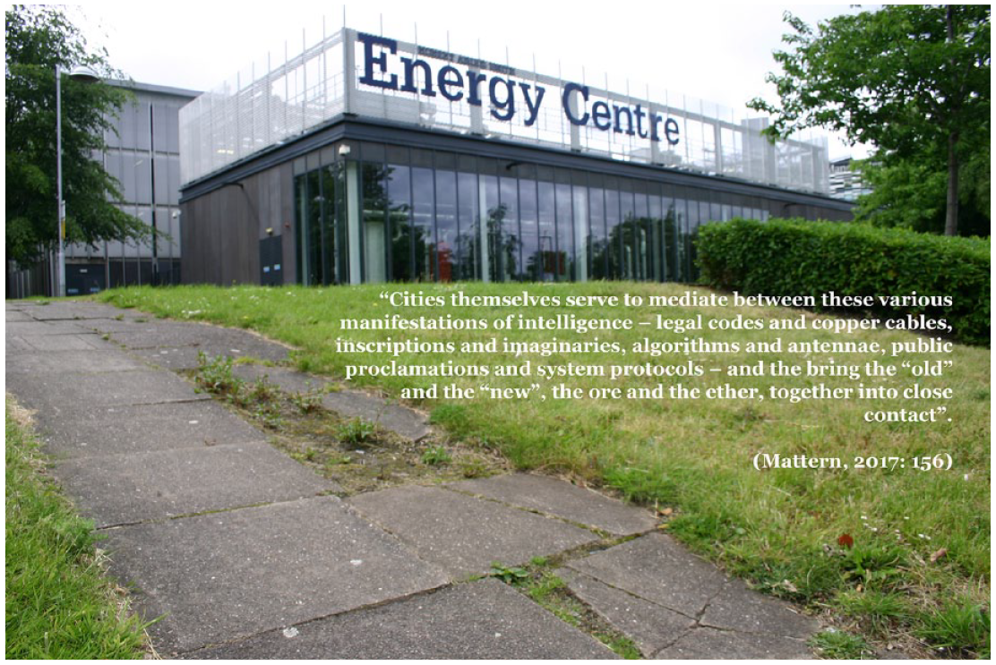
Urban innovation. A Siemens energy centre on the newly developed Birley Campus, showing the meeting of technology and the slowly wilding urban fabric. © Photograph: Emma Fraser and Clancy Wilmott.
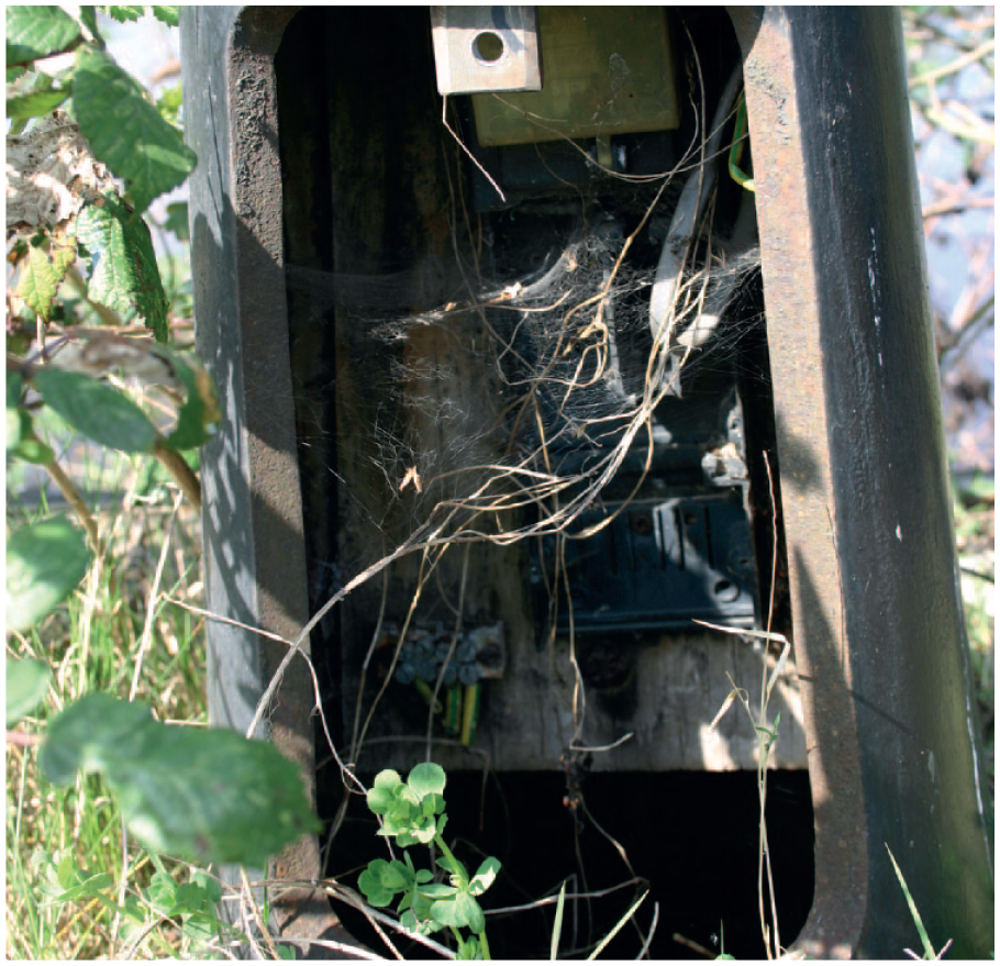
Web/sites. Plants, spiders and electric wiring in an old lampost on the promenade of Pomona Strand, 4 April 2019. © Photograph: Emma Fraser and Clancy Wilmott.
This article presents a series of photographs taken by the authors between February and June 2019, in two sites in Manchester and Salford. The discussion particularly delineates the contrast between the ‘smart’ and ‘networked’ innovation corridor along Manchester’s Oxford Road, and a large parcel of brownfield land in Salford’s Pomona area (adjacent to Media City), earmarked for regeneration in coming years, but currently wild and unkempt. In these two sites, and through a visual methodology (Harper, 1988), and using captions and titles adapted from the work of Mattern (2017a, 2017b), Haraway (2016) and Macaulay (1950, 1953), we track the meeting of urban innovation and wasteland, and uncover recombinant ecologies that persist within the smart city, as well as in the spaces beyond.
Where the Smart City Meets the Wasteland
British post-war writer Rose Macaulay understood ruination, and particularly the urban wilderness that stands alongside spaces of development and growth, as a counter-site for a devastating and sanitizing modernity. Macaulay’s novel The World My Wilderness (1950) depicts the overgrown ruins of London as places that visually and bodily challenge the progress-driven development of the modern city after the Second World War. Wilderness (and ruin, wasteland) go beyond metaphors for the profound destruction of war and urban renewal. Macaulay herself roamed the derelict remnants of churches and apartment blocks and, for her characters, the city of London was ‘where streets were paved and buildings stood up, and a solid improbable world began, less real, less natural than the wasteland’ (p. 74). Macaulay’s work on ruins is extended in Pleasure of Ruins (1953), where images of ‘new ruins’ (like those of post-war London), supported the sprouting of fireweed, vines and saplings, a wild world that resisted incessant change and renewal (pp. 453–455). Macaulay’s ruinous, verdant, wasteland tells us that human environments and human culture are entangled with ruins, an ecology that reveals progress and blind development to be a disavowal of the persistence of decay within the ever-renewing city (see the post-industrial remnants in Figure 7). Unlike romantic views of modern ruins as a straightforward return to nature, or an image of urban apocalypse (Apel, 2015; Woodward, 2002), this approach suggests a mutuality between human culture: the organic urban environment and the ever-present wilderness of plants, animals and compost. This attitude of contrast between adjacent urban zones, and particularly between ruination and urban development, is carried over in both the field-work approach and the maps presented in Figure 1. The selection of each site and the composition of the images as ecologies reflect tropes, techniques and imaginaries that permeate the visual cultures (Bal, 2003) of photography, cartography and the wider representation of the hypertechnical city.
Sites
The Oxford Road Corridor, or Corridor Manchester, is an ‘Innovation District’ in central Manchester, dotted with historic buildings and institutions, with a major arterial route running along Wilmslow/Oxford Road, making it a busy pedestrian and bus route. Enveloped within the Corridor boundaries are a number of higher education providers, cultural and arts institutions, science parks and labs, health services, and mixed public and private residential neighbourhoods (see Figure 1). Pomona Island (known locally as Pomona Strand or Pomona Wharf, also the name of an apartment block in the area), is a post-industrial ‘island’ that runs beside a river and two canals, sitting between Manchester, Trafford and Salford – an ecological, political and historical contact zone between three administrative regions and between different environments and eras of development. The island is connected to the surrounding area by a pedestrian bridge and a narrow strip of land that curves towards Media City. Historically, Pomona was a popular pleasure garden but, following a nearby factory explosion in 1887, was used for chemical processing and shipping before falling into (human) disuse in the 1970s.
Oxford Road is one of the key pedestrian and bus routes through the city; lined with iconic architecture, it is one of the city’s best-known streets. The Oxford Road Corridor bustles with students and academics from the two universities, and patients and workers from the nearby Royal Infirmary (with its ‘Citylabs’ 1.0, 2.0 and 3.0). The area is serviced by buses that line the corridor day and night, often crawling or at a standstill. It is a space that is regularly maintained, signposted, paved and landscaped to facilitate movement, but also to present a slick urban aesthetic. Along this corridor, wilderness, play and compost arise where they can, often along peripheral paths or neglected side-routes (see Figures 4 and 5). Pomona is a quieter space – vast, and often (mostly) empty. However, it would be a mistake to assume it does not feature in the everyday life of the city. It is in Pomona that playful and wild recombinant ecologies emerge more clearly and hint at the presence of the innovation districts and corridors nearby. Along the boundary of Pomona, the river and canal waters are used for leisure – rowing, fishing, even ‘wild’ swimming are common here in warmer months. Pomona offers a shortcut to the tram, but also a place for a relaxing walk with family, friends, or dogs; despite its muddy pathways and wild fields churned up by demolitions and strewn with rubble and remnant architecture, there is usually someone strolling through during the day. At night, the area becomes an informal party-zone, where groups set up sound systems under the bridge that carries the tram between Manchester and Media City, or gather with a bonfire to drink and add layers of graffiti to the already colourful concrete surfaces of the site. From either end of the large site, smart and innovation-focused development can be seen; from within, a layering of the long history of industrial modernity lingers in the grit and mud.

Sympoesis. In the edgelands of the smart city, signs of communities of compost persist. The iron-worked underside of a 19th-century railway bridge crosses over the Bridgewater Canal, the first canal in Europe. In the middle, a disused bollard has been repainted as a mushroom, evoking Anna Tsing’s (2015) mushroom at the end of the world, 4 April 2019. © Photograph: Emma Fraser and Clancy Wilmott.
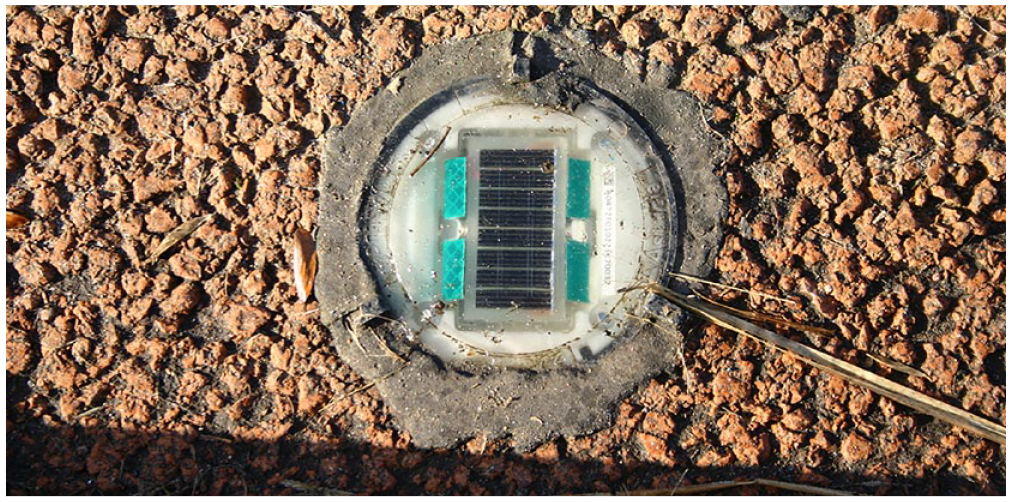
De-compos(i)t-ions. Dirt, muck, tyre marks and dead grass in the gradual erosion of a solar-powered light on the Oxford Road cycleway, a scene of urban innovation, up against compost, 2 February 2019. © Photograph: Emma Fraser and Clancy Wilmott.

Communities of compost. Community gardens sitting on disused land along the edgelands of the Innovation Corridor, in the shadow of new high-rise developments. Recombinant ecologies of people, plants and animals resisting incessant renewal, 31 May 2019. © Photograph: Emma Fraser and Clancy Wilmott.
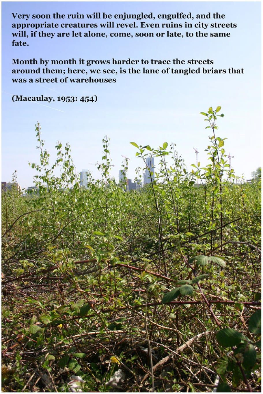
New ruins. Manchester City Centre, taken from Pomona Strand. Where Macaulay (1950) writes of decay that persists despite intensive urban development, shared futures emerge across Manchester via both cranes and shoots, 4 April 2019. © Photograph: Emma Fraser and Clancy Wilmott.
Together, both sites represent the spatial–temporal trajectory of a modernity particular to Manchester and Salford – early industrial, post-industrial and now hyper-technological and ‘smart’ (Kitchin, 2014). By using each site to understand the other, both can be read as edgelands: spatially, between boundaries, ecologies, actors and activities; and temporally, between innovation, obsolescence, construction and ruination.
Method
The method of this article is therefore one of visual contrast, between wilderness, ruin and compost, and progress, technology and innovation. Despite several attempts at redevelopment, Pomona is, functionally, a wasteland (as of June 2019). As such, it is a site of recombinant ecologies (Rotherham, 2017) – dirt and compost, rubble and weeds, overgrowth and detritus. Oxford Road Corridor is conversely a space of constant renewal, technological development and change. As this article shows, Pomona presents a vital challenge to urban life along the nearby Oxford Road Corridor and its wild presence specifically counters the progress-driven rhetoric of innovation districts and smart cities.
The process of taking the photos engaged a methodology of ‘walking-with’ (Springgay and Truman, 2017), moving-while-thinking with landscape, curating a fine attunement to the geo as a more-than-human space. The routes of the first two walks were designed in pragmatic terms: to move through both the Oxford Road Innovation Corridor and Pomona Strand in the same journey. Leaving from the most southern tip of Oxford Road, we journeyed northwards into Manchester city centre. The first walk split off onto a tram to Salford Media City, then eastwards through Salford to Pomona, to approach it from the nearest dense and smart hub of activity. The second was one walk, and headed west from the city centre along the Bridgewater Canal towards Pomona in Salford, to approach it via the formerly industrial canal. However, while these walks moved through the edgelands of Pomona, they adhered to the busy pedestrian routes along the central spine of Oxford Road. To rectify this, the final walk was through the western side of the Innovation Corridor, without a specific plan in mind – to walk-with the urban fabric and the play, wilderness and compost therein.
Across these three walks, over 800 photos were taken as documentation of the composting and wilding of the smart city. These images structured playfulness in their content and way of seeing the city, but also in the playful practices and interventions that they captured – often within or through wilderness and compost. Compost – as a practice – is itself a kind of methodology (Hamilton and Neimanis, 2018: np) – linked to caring and nurturing, carefully sorting organic matter to feed animals and plants, or to slowly rot into nutrient rich earth. But it can also be bound with care and attention in a more abstract sense; to apply the ethos of composting, of ‘paying attention’ to the fate of scraps and discards, constitutes intervention and resistance against the obsession with newness and consumption embodied in imaginaries of smartness. When dealing with encroaching and relentless spaces of innovation that crop up like so many invasive species in an environment, compost nurtures the fragile and organic ecologies (human and non-human) that develop along the borders of the smart city.
Play has a critical, resistant capacity – for example, it was an anti-capitalist, anti-progress strategy for the Situationist International, at the heart of psychogeography and counter mapping. Simon Sadler (1998: 32) describes their practices of detour through the hidden city, and subverting typical behaviour in urban space, as a ‘playful-constructive strategy’. Playfulness links to the wild and wilderness, as a strategy against inexorable progress and development, while mapping is a means to capture the fluid being-with the landscape that emerges from walking in urban space. To capture moments of play and movement in edgelands of the ‘innovation corridor’ is to find both a visual contrast between the push for smartness and the messiness of everyday life, and a kind of proof of sympoesis, of communities organically becoming-with the world around them, working and playing hard to ‘understand how to inherit the layers upon layers of living and dying that infuse every place and every corridor’ (Haraway, 2016: 138). A Mobike, tossed into the canal (Figure 9), is not simply vandalism – it’s a playful rejection of the smart city, an act that leaves the bike covered in muck – mired in decomposed, composted urban filth, the residue of centuries of innovation gathered in the sludge at the bottom of the canal. Mud and water, forgotten detritus, rule breaking and boundary pushing – these are the constituents of play, and the antithesis of the progress-driven city. By ruining the Mobike and cutting its Internet of Things connection that geo-locates the object (and charges for its use), a kind of wilding occurs, bringing the unchecked ecologies that flourish within and beside the canal into direct and contrasting contact with the imaginary of a shining, ‘smart’ city shaped by new models of tracking and consumption.
In the vein of this particular reading of compost, a small number of images were selected from the corpus collected throughout each walk. Each of the images presented is an attempt to move beyond the dualism of the built and natural environments, and instead understand progress as already in-decay, as being-with compost. Drawing on Suchman’s (2012: 48) description of the ‘configuration’ as method, and the mapping of technological artefacts and ‘imaginaries and materialities that they join together’, we extend this reading into urban spaces like Manchester and Salford. Through figuration, the images that we chose map, in a way, the socio-technical, socio-material, and non-human assemblages that compose the reality of the smart city – a techno-centric city that is already disintegrating. Furthermore, the images were selected because they also explore the ways in which processes of sympoesis disintegrate (literally and figuratively) the rhetoric of newness that comes with innovation. Donna Haraway (2016: 125) describes sympoesis as ‘a carrier bag for ongoingness, a yoke for becoming-with, for staying with the trouble of inheriting the damages and achievements of colonial and postcolonial natural cultural histories in telling the tale of still possible recuperation’. These images take the ethos of recuperation across multiple sites to investigate the relationship between sympoesis and compost as an ‘unbecoming-with’, ongoingness as undoingness, between multiple industrial pasts, presents and futures.
The visual methodology displays these perpetually overlooked organic transformations and recuperative strategies as entanglements within and against the smart ‘innovation’ city. The long modernity of both Salford and Manchester is particularly bound between relentless innovation (from steam and cotton mills, to cycle paths and energy centres) and material collapse (urban decay, as well as the more subtle rot of time and weather) – not least because the region is one of the rainiest cities in the world, where every path and field in winter is a mess of decomposing matter – odorous mud and opportunistic growth – like so many mini compost heaps.
Compost, Wilderness and Play In the Future City
There is also a playful element to this method of visually capturing and resisting uncritical renewal (and the related technological boosterism) in both active and disused urban space. As Ben Highmore (2013: 332) states of young people’s play in ruins and wastelands in the UK after the Second World War: ‘Placed together, untamed urbanism (waste-grounds, bombsites, street corners) and adolescent youth generate an image that unsettles the promise of unfettered progress.’ For Mary Flanagan (2009: 3), such play is political: ‘related to ancient divination, psychoanalysis, utopian tax laws, social protest, or environmentalism’, play is expressly linked to subversion, particularly in urban space (Flanagan, 2009: 10), resisting boundaries, governance and rules by exploring the limits of what is normal and permissible. Thus, much of what we did in capturing aspects of each site was intentionally playful. In the case of Pomona, the entire site stands as a rejection of the smart city; an open, ruinous playground frequented by locals who leave myriad marks of their presence (see Figures 8, 9 and 10). Along the Oxford Road Corridor, playful subversion must be sought out, actively courted: looking for cracks in the pavement; spying weeds growing through the fence line, and mildew developing along the bottom of a broken bollard; counting speed cameras and smart poles; and timing the dash to the bus stop on the other side of the rush-hour cycleway (see Figures 5 and 9).

Transgression. Looking westward towards Salford Quays, Pomona Wharf is a regenerating area, graffiti hotspot and home to over 125 species of birds (Marsden, 2016), 2 February 2019.
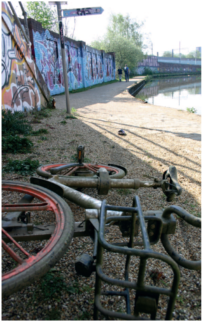
Urban play. In 2017, Chinese company Mobike started a free trial of dockless bike-share services in Manchester, run via a mobile app that collected user data. The bikes quickly became repurposed with high rates of destruction and theft. This bike, pulled from the Bridgewater canal next to Pomona, has been relieved of its digital GPS tracker and locking mechanism. In 2018, Mobike gathered what remained of the 1000 bikes introduced into the Manchester environment and ended the trial, 4 April 2019.

Untamed urbanism. In the ghosts of play, a prosecco bottle-plant-drain-road assemblage forms on Pomona Strand, 2 February 2019.
This playful approach opens up otherwise overlooked urban phenomena, providing a space where materiality, history, innovation and everyday life meet – mess and order together. As Shannon Mattern (2017a: 156) notes of the contemporary city: ‘clay and code, dirt and data, pasts and presents intermingle here. And – provided that our future cities are designed to accommodate these untidy, productively “confused” materialities and temporalities, to amplify the echoes of the past – they always will’ (for example, see Figure 3). Like Macaulay, Mattern (2017b) identifies a tendency to over-invest in rhetorics of progress that overlook complex materialities and ecologies. Her work is specifically critical of smart, innovation-led, development-driven logic, ways of thinking about urban space that obscure the landscapes, environments, people and things that constitute the city – ‘[in reality], urban environments everywhere are characterized by a lot of messy materiality, residual media and different notions of ambient intelligence, sometimes even reflecting competing epistemologies and clashing politics’ (such politics are mapped in Figure 8, between wasteland graffiti and rapidly developing Salford in the background).
Conclusion
Composting is a ‘multipurpose concept’, a ‘material metaphor’ for relationships between processes of thinking and living (Hamilton and Neimanis, 2018). To understand composting as both a method and a conceptual tool – as well as a material process of rot and subsequent nourishment that is often overlooked – is to engage with the transmogrifying power of compost, both as matter and process: play and wilderness also transmogrify; wilderness transforms sites of industry and urban development into tiny private jungles (Figure 7); and play transforms oppressive spaces of innovation into more human and vibrant worlds.
As this article shows, there are unifying, but also competing, epistemologies and materialities of the Innovation Corridor (in direct contrast to Pomona’s neglected wasteland on the brink of redevelopment). One is a link to technology and innovation, including entrepreneurial ‘labs’ and offices for collaborating on tech-based development; another is the Wilmslow Road dedicated cycleway, a green-paved path that connects with key points along the corridor; and the third is a sustainability narrative that brings both tech innovation and green thinking together. The cycleway and major roads through the corridor are dotted with solar panels, solar lights, weather and pollution sensors, free wi-fi zones, and other ‘smart’ and/or sustainable technologies. A ‘smart city battery’ and other ‘green technology’ (Manchester Metropolitan University, 2018) feature elsewhere in the zone, alongside a sustainability trail and edible gardens (see Figure 6). These developments are brought together under smart-focused rhetorics of technological development, vaunting sustainable goals and hyping entrepreneurial knowledge innovation, invoking contemporary discourses of smartness (Dalton et al., 2020).
This ‘smart’ city, with its data-driven, analytic and ‘real-time’ framework (Kitchin, 2014) lauds new urban infrastructures and opportunities for growth and progress through technology-led innovation, with little regard for a wider historical context, local residents or complex ecologies. It is notable for Manchester and Salford that discourses of the smart city contain the same visions of growth and progress that typified the conversation around the industrial city – the binary of human mastery over nature, of growth annihilating decay and technological control over unpredictable, organic systems. Yet, as the industrial city declined after its heyday, we must ask what the ruins of the smart city will look like – those that are to come, but also those that are already here.
Footnotes
Funding
The authors received no financial support for the research, authorship and publication of this article. There is no conflict of interest.

Biographical Notes
EMMA FRASER is a Lecturer in Media and Cultural Studies in the Department of Sociology at Lancaster University.
Address: Department of Sociology, Lancaster University, Lancaster LA1, UK. [email:
CLANCY WILMOTT is Assistant Professor in Critical Cartography, Geo-Visualization and Design in the Berkeley Centre for New Media, and the Department of Geography at the University of California, Berkeley.
Address: Department of Geography, UC Berkeley, 505 McCone Hall, Berkeley CA 94720, USA. [email: