



Abstract
For a decade from the late 1990s, the A-Z London street atlas became a recurrent motif within art works and popular media texts. This essay collates and explores these cultural responses to the atlas, to consider what this might reveal about the affective dimensions of ordinary urban way-finding. There were three persistent motifs that ran through these diverse works: a basic fascination with the destruction of the atlas, the foregrounding of a stoic or heroic pedestrian figure, and the attachment of the atlas to a projected network of mobile individuals that connected on the streets at random times and places. An interrogation of these tropes reveals how the A-Z became a means to explore the terms of an expanded pedestrian experience, as well as a possible configuration of metropolitan movement and contact. Furthermore, the popularity of these texts points to an excess of affect that might have become embedded within acts of A-Z way-finding. Using, owning or being seen with the atlas briefly became a potential mechanism for imagining one’s contribution to a mobile metropolitan community. Hence, this essay is both a focussed exploration of street-atlas poetics and an attempt to think more deeply about the cultural dynamics of everyday urban navigation.
From the late 1990s and for about a decade, the London A-Z enjoyed a new cultural prominence within Britain. No longer merely the capital’s best-selling street atlas, it began to be celebrated as a bona fide metropolitan icon and an essential part of London’s modern infrastructure. Across a range of texts that included fine art graphics, a performance piece, television programmes and popular fiction, the A-Z was treated as a cartographic enigma which, if considered closely, might yield up hidden secrets about London as a system of mobility or a network of people in motion. This ordinary, everyday street atlas had become something of an urban muse.
During this same period, the A to Z’s arrival on the shelves in 1936 was canonised as a seminal event within the history of modern cartography. 1 In 2005, Nicholas Crane dedicated an episode of the television programme Map Man to it, one of 16 landmark British maps he explored across his two-series run. 2 A year later, ‘The Great British Design Quest’ (a joint venture between the BBC’s The Culture Show and the Design Museum in London) went further by naming the A to Z among the 25 top British designs of the 20th century. 3 Both programmes heaped a great deal of praise on Phyllis Pearsall – the atlas’ creator and founder of what is now the Geographers’ A-Z Map Company Ltd – and drew heavily on Sarah Hartley’s best-selling biography, Mrs P’s Journey, of 2001. In 2005, Southwark Council affixed a commemorative blue plaque to the house in which Pearsall had been born, and Southwark Playhouse premiered its new musical, The A-Z of Mrs P, in 2014.
This essay reflects on this concentrated wave of interest in the London A-Z and considers what it might tell us about the practices and performances of urban navigation. During this period, A-Z musings appeared across a range of media, in diverse aesthetic registers and for different target audiences, but gathering these texts together highlights several recurrent tropes. First, cultural producers were repeatedly drawn to the atlas’ defilement or physical destruction. Second, it was persistently linked to a heroic lone pedestrian who endured long and arduous walks across London. Third, a number of texts used the atlas to project a particular network of metropolitan mobility, to which it was then presented as the privileged point of access. These three motifs, used in various combinations by different writers, artists, programme-makers and performers, constructed a distinctive set of meanings around the A-Z, its users’ urban mobility and their social relations on the pavement. At its most elaborate, London was presented as a dispersed agglomerate of atomised individuals who each determine their own spatial trajectory, but who momentarily interconnect at contingent times and places. The structure of this metropolitan projection was deeply tied to the street atlas’ political inheritance as a cartographic form.
Importantly, this concerted cycle of A-Z texts showed a notable interest in the haptics of way-finding as a quotidian urban practice. Thus, it anticipated the recent shift within critical cartography from deconstructing maps as partisan spatial descriptions to exploring their production of proximate space within contingent navigational acts. 4 In the late 1990s, texts like Geoff Nicholson’s Bleeding London and Iain Sinclair’s Dark Lanthorns had already progressed from critiquing the A-Z’s schematic representations to considering its potential to script uncommonly expansive encounters with the city. Here and elsewhere, the A-Z became figuratively attached to a richer, more autonomous form of pedestrian experience that was seamlessly folded back into its users’ daily lives.
Other texts extended these dynamics beyond this more limited focus on the individual way-finder. During this era, it became common to present the A-Z as a universal instrument of London living, something surely utilised by every inhabitant and visitor to the city. Once this had been established as a truism, each A-Z navigation could be invoked as a small participatory act that bound the user into a larger fraternity of mobile metropolitans. This theme recurred in diverse ways within works by Lone Twin, Lars Arrhenius and Hartswood Films for the BBC. Its consistency across these texts, or that it was already understood by their respective audiences, suggests that during this period, actual events of A-Z way-finding might have resonated beyond the obvious functionality of getting from A to B. This article, then, responds to recent calls by a number of scholars to extend map studies beyond its traditional focus on cognitive processes, and to explore instead the emotional or affective dynamics of cartographic navigation that are often occluded within conventional accounts. 5
From alienated images to meaningful performances
The first texts to conspicuously foreground the A-Z appeared as part of the renewed interest in London psychogeography that emerged during the mid-1990s. 6 Geoff Nicholson’s novel, Bleeding London (1997), and Iain Sinclair’s suite of essays, Dark Lanthorns (1999), were pioneers in this respect; but both also displayed a marked ambivalence towards the atlas that would come to characterise many later responses to it.
Nicholson’s Bleeding London follows the narratives of three separate protagonists as they circulate around the capital. One of them, Stuart, is a London obsessive who tries to reconcile his relationship to the city by walking every one of its streets – a distance, he calculates, of 8,318 miles, plus an extra margin for the unavoidable doublings back. To mark the start of his venture, he buys himself a brand new copy of the London A-Z, plus a black marker pen with which to score out each road as a record of his progress. Before long, he feels an additional need to keep a diary, in which – towards the end of his quest and with his A-Z almost black – he logs the following thoughts: Soon I will no longer have use for a map. Maps are euphemisms, clean, clear, self-explanatory substitutes for all the mess and mayhem, the clutter and ambivalence and blurring and intermeshing weft and warp of the real places they purport to describe. They are fake documents, pathetic simplifications and falsifications. They’re no longer necessary since I have created a new London, not one made out of stone and brick, tarmac and concrete, but a London created out of memory, imagination and shoe leather.
7
In this passage, Stuart rehearses a critique of ichnographic street plans that was becoming orthodox in 1997. In The Production of Space (belatedly published in English in 1991), Henri Lefebvre had attacked urban street maps for reifying the living city and deploying a set of cognitive abstractions to colonise a terrain they claim only to describe. Under the guise of scientific objectivity, he argued, such maps nullify the sensuality of urban life, while obscuring their own deep complicity with institutional systems of power. 8 Similarly, Michel de Certeau (whose The Practice of Everyday Life appeared in English in 1984) criticised street plans for freezing the city’s dynamism within a sterile and abstract ‘nowhen’. Such representations, wrote de Certeau, force their reader to adopt an omniscient God’s-eye view, gazing down upon a treacherous geometry from which all the cities’ poetic contingency has been erased. 9
As an ordinary functional street atlas, the London A-Z was easily amenable to this kind of representational critique. In a book published the year before Bleeding London, map historian Jeremy Black used the phrase ‘the A-Z-ing of life’ to dismissively describe how such street plans reduce urban space to an homogeneous network of empty roads. Diverse places of human habitation, argued Black, are drawn as little more than the negligible gaps between traffic conduits. The city on the page becomes just ‘a space to be traversed, a region to be manipulated or overcome in the individual’s search for a given destination, not an area to be lived in and through’. 10
Both Lefebvre’s and de Certeau’s critiques were historic responses to the state-led urbanisation of post-war France, so it is fitting that Stuart’s desecration of his atlas in Bleeding London had a clear historical precedent in Guy Debord’s Situationist praxis. To create ‘The Naked City’ in 1957, Debord’s most famous attempt to produce a ‘renovated cartography’, he also vandalised an ordinary copy of a mass-produced urban street atlas. 11 Critics are divided over which one he used – Simon Sadler cites the Guide Taride de Paris, while Tom McDonough names the Plan de Paris – but in either case, the process was the same. 12 Seeking to chart the affective topography of central Paris – clearly inadmissible according to a street atlas’ conventional schemata – Debord extracted 18 segments from its component maps and reconfigured them anew upon a fresh piece of paper. He then connected up these fragments via a network of bold red arrows, which, according to the map’s subtitle, revealed the ‘psychogeographical turntables’ (‘plaques tournantes en psychogeographique’) that circulate the drifting walker along currents of meaningful experience. Debord’s map, then, inaugurated a critical dialectic that Stuart would repeat over the course of Bleeding London. To achieve a richer and more socially aware account of the terrain, the abstract epistemologies of the everyday street atlas had first to be (literally) destroyed.
Stuart critiques his A-Z maps near the beginning of Nicholson’s novel. Although taken from a much later diary entry, this provides an intriguing flash-forward moment from which the author loops back to recount the preceding tale. Indeed, by the book’s final chapters, Nicholson has become much more ambivalent about what exactly his character has achieved. Physically exhausted and overwhelmed, Stuart’s thoughts turn increasingly to suicide, which now seems like his trek’s only apposite conclusion: I realized that the end of my wandering should be, not simply the blotting out of the city, but also the blotting out of the self. When the map was all blacked in I’d be ready to be snuffed out. And I know I don’t have to plan it. It’s there waiting for me, something suicidal, although the inquest won’t call it that. […] Tomorrow I take to the streets for one last time, the last stretch, the last ten miles. And when it’s done he’ll be waiting for me, my fate, my killer.
13
As its title indicates, Bleeding London is a novel that strives to be about the metropolis, rather than to merely be set there. Stuart’s full name is thus ‘Stuart London’, a shameless plot contrivance that makes his final bid for self-annihilation a bit too implausibly neat. Yet when, in the novel’s concluding pages, Stuart is saved from his untimely end, this also reveals the critical bad faith on which his project has been built. Despite his despondency, he has not really ‘blot[ted] out the city’ but only its cartographic representation – a category error that shows how for all his apparent critical awareness, he finally mistook the pathetic simplification for the places it purports to describe. As his diary makes clear, the mess and mayhem of the city’s streets necessarily exceed any passing attempt to fix them in representation. Those streets will always be there again tomorrow, ready to reveal some new contingencies to the open-eyed pedestrian. Like its personification within the novel, London itself can never be properly finished.
Why, then, should Nicholson’s character finally equate his blackened-out atlas and his soon-to-be-blotted-out self? A clue, I think, lies in an earlier scene in which his other two protagonists first meet. Mick, a tough guy from Sheffield, arrives in an unfamiliar London to track down and punish the men who assaulted his girlfriend. Bewildered by the city’s size and complexity, he enters ‘The London Particular’, a specialist bookshop in which Judy – the novel’s third main character – serves behind the counter. Judy, of course, ‘set[s] him up with an A-Z’. 14 Later on, Mick will reflect warmly on how his atlas has guided him through the city and left him with a greater sense of its once impossible layout. Mick’s copy of the A-Z, then, is shown to nurture an at-home-ness within London, just as Stuart’s worsening estrangement is marked by the destruction of his own. In only critiquing it as a false representation, Stuart ends up destroying the one technology that bound him into the life of the capital. Its maps may indeed be euphemistic images, Nicholson ultimately suggests, but in orienting Stuart to its myriad streets, they provided the lifeline on which his metropolitan identity depended.
Two years later, Iain Sinclair made similar intimations in his short book, Dark Lanthorns, a further instalment of his ongoing engagement with the cabbalist scholar David Rodinsky.
15
When Rodinsky vanished in 1969 from his attic above the Princelet Street Synagogue in Whitechapel, one of the objects he left behind was a copy of the London A to Z. Upon perusal, several pages were found to have been drawn over with networks of spindly red lines, which, for Sinclair, held the tantalising promise of psychogeographical revelation: I decided that the only way to make sense of Rodinsky’s doctored map was to walk his red lines. I would pick three of the most energetically scored pages and treat his promptings like a film script. I would follow his score with a camera. […] How it would play and what it meant would remain a mystery – until the journeys were completed and the tapes looped on monitor screens.
16
Dark Lanthorns is a meditative record of the three walks that Sinclair undertook with Rodinsky’s A to Z, a project that rested on the same critical dialectic as that deployed by Stuart London and Debord. Here, the peculiar value of Rodinsky’s atlas lies in its historic defilement. Its annotations immediately come to signify a more profound territorial knowledge than its original abstract diagrams. Rodinsky’s trajectories, Sinclair concludes, are the ‘discrete chapters of an incomplete and unwritten autobiography’, the scholar’s attempt to resolve his own displaced identity by revisiting places with personal association or connections to his sense of Jewish heritage. 17 Yet, an important irony runs through Sinclair’s project; in performing these walks, he writes, he is wilfully ‘(mis)interpreting Rodinsky’s embellishments’. 18 Thus, while committed to reanimating this forgotten figure within the landscapes through which he once passed, Rodinsky’s scribbles are equally an excuse for Sinclair to launch his own peripatetic inquiry into the state of millennial London. As his thick topographical descriptions unfold, both in the book and in its accompanying video work, these mysterious marks start to lose their specificity, to become eclipsed by a more general appreciation of the A-Z’s ability to facilitate urban interrogations.
This shifting emphasis was most clearly captured within Dark Lanthorns’ material form. Published as a limited edition by the independent Goldmark Press, the book was meant to look and feel as close as possible to Rodinsky’s original atlas. Its life-size front cover cleverly pastiched the late 1960s A to Z design (Figure 1), while a contemporary Tube Map was reproduced on the back, its ink now apparently blurred by moisture. This mimicry continued inside, where several double-page spreads appeared to be directly taken from the earlier atlas, their yellowing pages covered in sun spots and Rodinsky’s red annotations. A fake Cadbury’s chocolate-bar wrapper was even loosely inserted into the book with his enigmatic scribbles on the verso.
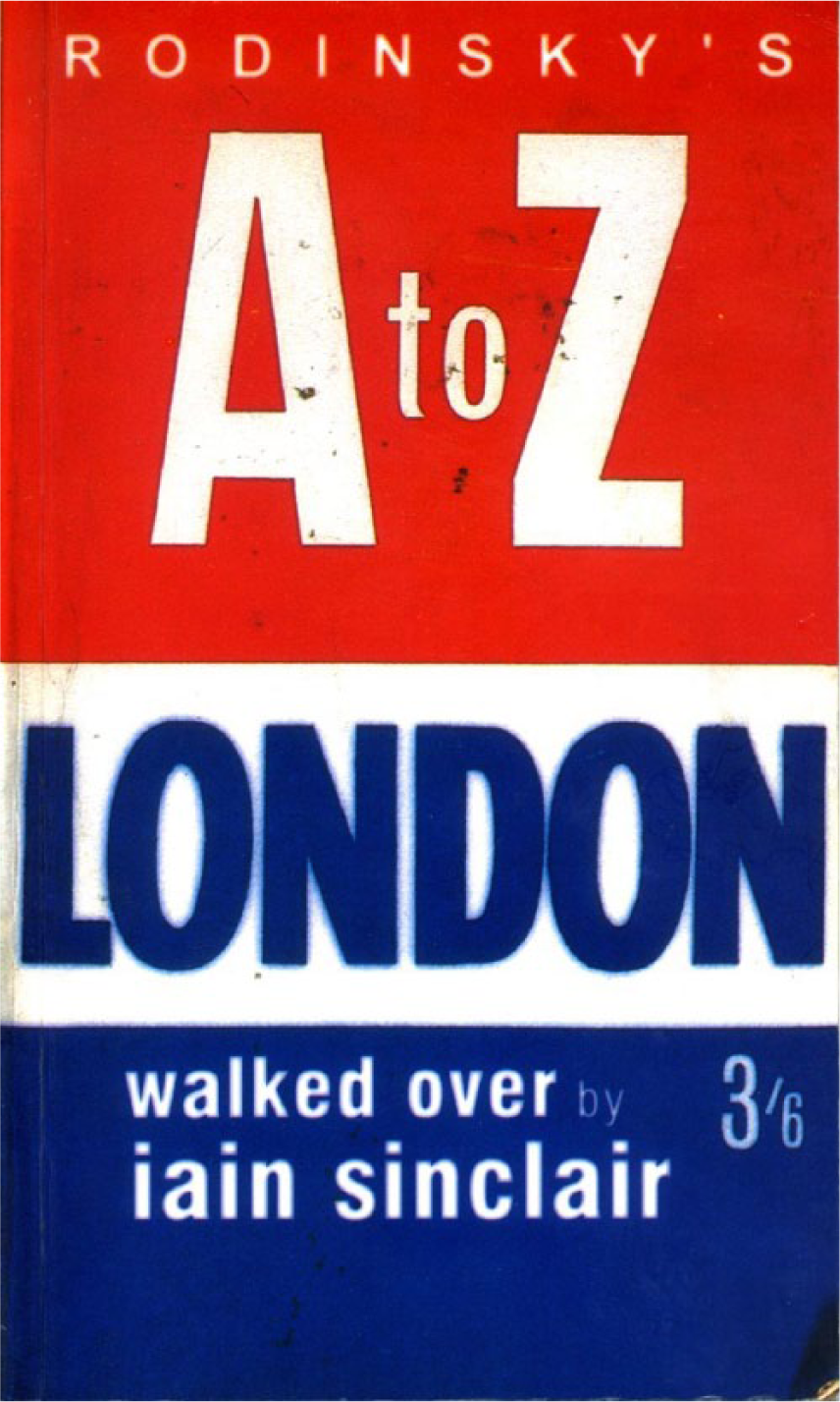
Front cover of I. Sinclair, Dark Lanthorns: Rodinsky’s A to Z (Uppingham: Goldmark, 1999). (With the kind permission of Goldmark, Uppingham, Rutland).
As Christopher Gregory-Guilder notes, this publication strategy served to consecrate Rodinsky’s A to Z, while transforming the object in the reader’s hands into ‘a kind of splinter of the holy cross’. 19 As a tangible commodity, Dark Lanthorns asserts a powerful aura; it both palpably recalls those other A-Zs that the reader is presumed to have handled and evokes the unique singularity of a hallowed holy relic. This strange doubling makes the book’s facsimile maps feel like something of a challenge. Rodinsky’s drawings are generally more complex than the linear routes documented within Sinclair’s essays. It is hard, therefore, not to scrutinise his marks for some deeper significance, plotting out alternative routes that Sinclair might have taken, or which, by haptic invitation, one might now go out and walk oneself.
In these moments of active cartographic perusal, the psychogeographical richness within Rodinsky’s markings starts to dissipate outwards – much like the ink on the book’s ‘rain-soaked’ back cover – to inflect those other, more ordinary A-Zs that the reader is presumed to know. Rodinsky’s and Sinclair’s extra-ordinary journeys become entwined with the accreted somatic memory of our own, less remarkable A-Z navigations – times we might have employed the atlas on the street or idly plotted out some speculative journey. Like Bleeding London before it, therefore, the foundational critique on which Dark Lanthorns was built turns into something more complex. By focussing our attention on the atlas as a haptic technology, rather than as a set of cartographic representations, the initial binary between the vandalised atlas and its mass-produced cousins starts to break down. What appears in its place is a more general valorisation of the A-Z, as an everyday technology with the residual power to provoke exploratory urban experiences.
Scripting the (extra-)ordinary pedestrian
This paradoxical conflation of the ordinary atlas with an extra-ordinary mode of moving through the city was soon to be restaged within accounts of the life of Phyllis Pearsall, now enshrined as the A-Z’s creator and a standard reference point within TV programmes and magazine articles. Pearsall first came to public attention via the journalist Sarah Hartley’s 2001 biography, Mrs P’s Journey: The Remarkable Story of the Woman Who Created the A-Z Map. This told of how Phyllis – a valiant divorcee in her early 30s and the daughter of exiled mapmaker, Alexander Gross – experienced an epiphany in 1935 after getting lost on her way to a dinner party in West London’s Maida Vale. As she arrived late and wet from the rain, the diners’ conversation naturally turned to the difficulty of finding an unfamiliar metropolitan address: ‘One does find it tremendously hard to negotiate London, especially if one is rarely in Town’, chipped in Lady Veronica [the hostess]. ‘Yes, but do you not find that unless you are in a taxi, there is no clear way to know how to get to where one is going?’ queried Lord Knott [her husband]. This conversation would nag at Phyllis all through the remaining duck and brandied-plum courses, and then through the night. The very next morning, she became determined to find a street map of London.
20
Upon visiting Foyles booksellers in Charing Cross Road, Hartley recounts, Pearsall was sold two copies of the Ordnance Survey map of London, which had not been updated since 1919. Upon examining them back in her room, Phyllis became indignant: ‘By the government for the government’, she murmured, ‘but what about me? What if I want to go from here’ – she stuck her finger on Chiswick High Road – ‘to here’ – and she stuck another on Highgate. ‘There’s no index. No London Underground markings. No house numbers’. As her artist’s eye noted that new roads were nowhere to be seen, she tutted at the misuse of space and the lack of colour. What is more, the map was full of inaccuracies. ‘This just will not do’.
21
At that moment, Pearsall resolved to produce her own London street atlas to plug this yawning gap in the cartographic market. Refusing the help of her more experienced father, she set out on an epic hike to chart her territory and spent a year trudging through London’s streets for 18 hours a day. Next, she began the challenging task of indexing all the road names, carefully filing them into 26 shoe-boxes she kept stacked-up in her bedsit. Thankfully, her labours would not go unrewarded. Upon its publication in 1936, the A to Z was so successful, Hartley tells us, that Phyllis spent several months carting copies through the streets on a borrowed hand-barrow just to keep the shops supplied.
Despite its popular success, Hartley’s tale of inspiration, ingenuity and determined hard graft is not particularly reliable. Pearsall’s own self-published autobiography contains no mention of any Maida Vale dinner party. 22 Instead, from earlier in 1935, she was already involved in producing maps for her exiled father who was now eager to re-establish himself in Britain. The idea for a comprehensive street atlas of London actually came from Frank Crowley – Pearsall’s uncle and Gross’ London salesman – who persuaded his brother-in-law to set Phyllis to work on its index. The original A to Z, then, was far from a singular creation, while Pearsall’s ambulatory endeavours were also less arduous than Hartley implies. Although she did trek down London’s thoroughfares to note the building numbers at each important intersection, most substantial post-war developments were directly copied from updated maps already held by the city’s Borough Surveyors. If a new estate was still under construction, Pearsall recalls, the agent would usually drive her out to the building site himself. Thus, she only had to walk around those few developments whose records were either too poorly drafted or to which officials had denied her access.
In sum, the A to Z was less of a radical innovation than a further refinement of a cartographic form already well established when Pearsall began work. Collins’ Illustrated Atlas of London – now generally recognised as the city’s first portable indexed street atlas – was initially published in 1854, although it spawned few imitators in the decades that followed. 23 By the end of the 19th century, however, London had become so massive that single-sheet maps were either too illegibly crammed with information or else too unwieldy to handle in the street. Before long, a rash of street atlases had appeared, to provide residents and tourists with a more practical tool of urban navigation: Philips’ Handy-Volume Atlas of the County of London (from 1891), Bacon’s Up-to-Date Atlas and Guide (from 1896), Philips’ ABC Pocket Atlas-Guide to London (from 1902) and Bartholomew’s Handy Reference Atlas of London & Suburbs (from 1908). 24 In 1922, Gross’ old company, Geographia Ltd, joined the fray with its Authentic Atlas & Guide to London & Suburbs, which continued to be published until the outbreak of the Second World War. Thus, if Pearsall had gone into Foyles in 1935, she would have been offered many more useful maps of London than the cumbersome Ordnance Survey sheets that Hartley now proposes.
With its themed diagrams of London’s ‘Theatreland’ and ‘Clubland’ and an informative section on ‘Places of Interest’, Pearsall’s first A to Z deviated little from other street atlases already on sale. Its advances were modest: an updated coverage of suburban estates and inner-city developments, the inclusion of house numbers at various points along major roads and a greater level of typographical economy due to Pearsall’s rejection of expensive colour lithography for monochrome printing on lower quality paper. None of these was innovative enough to attract the attention of the contemporary media.
For all its flaws as an historical tome, however, Mrs P’s Journey helped turn the A-Z into a cartographic icon by fixing it in the popular memory as an innovative pioneer. The image of Phyllis fearlessly striding down the road in her wool suit and stockings also chimed well with contemporary post-feminist investments in streetwise urban heroines (cf. Sex and the City’s Carrie Bradshaw), while emphasising the democratic credentials of this cheap and seemingly ubiquitous atlas. Most seductively of all, however, Pearsall’s embellished London walk gave a novel associative weight to those present-day navigations that she was now seen to have enabled. Mrs P, of course, never appears in this story as an A-Z user; as the atlas’ compiler, her exhaustive knowledge of London’s layout marks her as the one person for whom it would have surely been superfluous. Yet once installed as the exemplary metropolitan pedestrian, each and every journey undertaken with her atlas could now be imagined to express a little bit of her original spirit. Indeed, the book’s popularity even suggests that a broad common feeling had already become attached to practices of A-Z way-finding, a heightened sense of purposive exploration that made this retrospective origin myth both plausible and fitting.
This figure of a wilful, autonomous pedestrian creates a clear thematic link between Hartley’s book and those of Nicholson and Sinclair before her. Mrs P’s apocryphal trek through London’s 23,000 streets repeats the terms of Stuart’s quest in Bleeding London. Yet, it also displaces his obstinate perversity and substitutes instead a canny entrepreneurialism with enough force to propel Pearsall from bedsit to boardroom. Mrs P’s unwavering work ethic may mimic the ambulatory dedication of both Rodinsky and Sinclair, but it places her atlas neatly outside any critical agenda. In contrast to the Situationists’ cry of ‘Ne travaillez jamais!’ (‘Never work!’), Pearsall is made to rigorously adhere to the rhythms of the business day. Her atlas may instigate unusually expansive encounters with the built environment, this biography infers, but these remain entirely integrated into the work-life of the capital.
Indeed, for all its dubious claims about the A to Z’s originality, Mrs P’s Journey was deeply attuned to the atlas’ occluded cartographic inheritance. As Patrick Joyce has shown, London’s street atlases of the late 19th century already promoted a form of urban subjectivity that accorded with the ethos of the free market economy. Throughout the Victorian era, the English highway had been discursively enshrined as a stage of national liberty on which individual citizens were free to govern the terms of their own mobility. The visible result was a complex, harmonious, but uncoordinated pattern of collective movement, taken as evidence that the pursuit of self-interest naturally secured the greater common good. 25 As Joyce notes, the initial wave of London street atlases reinforced this ideological perspective; as navigational tools that could easily be consulted by individuals in the street, they fostered ‘an autonomous, rather calculating and alert private self . . . in purposeful and easeful movement through [the] city’. 26
When television programmes like Map Man (2005) and The Culture Show (2006) framed the A to Z as an innovative response to the challenges of navigating interwar London, they concealed this important technological inheritance. 27 Indeed, upon its arrival, Pearsall’s atlas was already rather archaic, for by 1936 the spatial freedoms of the previous century were firmly in decline. From the mid-1920s, the proliferation of motor cars on London’s streets had caused a swift increase in the number of serious road accidents. By the end of the decade, municipal administrators had begun to experiment with ways to orchestrate the movements of its traffic. Pedestrian behaviour was a key concern, for the increased speed of automobiles – unmatched by any quickening of drivers’ reaction times – meant that walkers’ actions had to be made more predictable in order to be rendered safe. In June 1934, therefore, a network of pedestrian crossing places was introduced across the city, which mimicked the binary alternations of the railway level crossing in an attempt to govern where, when and under what conditions a foot passenger might step into the carriageway. Walkers were now obliged to submit to a pointsman or set of automatic lights, to vigilantly attend to the signals being given and to proceed only as directed. By way of reinforcement, stretches of metal guard rails were installed along the surrounding kerbs to marshal pedestrians onto the lanes and physically prevent them from stepping off elsewhere. All this, of course, fundamentally eroded the principles of pedestrian sovereignty that had largely gone unquestioned before the 1920s. 28
If the disciplinary impetus of these roadside technologies is now rarely noted, the A-Z still requires its users to engage with the urban environment via a purposiveness that disrupts any state of habituated docility. Its index at the back allows users to locate both their current position and their proposed destination upon its component street plans; yet, the atlas has never been able to suggest a route to take between the two. Navigators have always had to project their own tentative trajectories across its pages, before relating these back to the unfolding terrain in an ongoing dialectic of orientation and revision. 29 Furthermore, these performative dynamics were originally exaggerated by the A to Z’s low production values. Pearsall’s choice of solely black ink on thin, absorbent paper meant that narrow roads had to be drawn especially wide for their names to be legibly inserted. This produced a greater visual parity between the city’s major thoroughfares and its most minor alleys – a tacit invitation, perhaps, to come off the busier main roads and risk an unfamiliar shortcut through the web of quieter side-streets. Any resultant zigzag, already through terrain less governed by guard rails and crossing lanes, would demand from the navigator a greater vigilance in relation to the passing environment.
Of course, the unfamiliar journeys for which the A-Z is typically deployed already take way-finders beyond their circuits of habitual mobility. Yet the atlas’ navigational mechanic exaggerates this defamiliarisation by demanding from the user a greater directional autonomy and a more acute scrutiny of the surrounding streetscape. The atlas’ pocket-book format also precludes the kind of cognitive overview endemic to the single-sheet map. In a strange reworking of ‘The Naked City’, navigators face an interlinked chain of cartographic fragments that restricts their orientation to the scale of the present district. 30 Although these divisions are arbitrarily imposed by the atlas’ mass production, they also promote awareness of local nuances, atmospheres and tones. The A-Z’s experiential scripts are thus antagonistic to administrative elements within the contemporary highway, even while the atlas remains unremarkable to use. Taken together, the determined, exploratory and individualist walks that run through Bleeding London, Dark Lanthorns and Mrs P’s Journey all register this inherent tension within acts of A-Z navigation.
Networks of urban mobility and contact
Several cultural texts went further and used the A-Z to consider how a multitude of mobile individuals might coalesce to form a larger metropolitan system. In doing so, they extrapolated from this basic notion of pedestrian sovereignty a holistic network of atomised movement and casual urban contact. The A-Z street atlas thus became a pivotal device for exploring the terms of street-level sociability or how London’s mobile citizens may (or may not) connect up on the ground.
In 2000, for instance, the live art group Lone Twin debuted a piece entitled Streets of London at the Milch Gallery in Bloomsbury. This began when the group’s two members, Gregg Whelan and Gary Winters, tore out the index of a spiral-bound copy of the A-Z and scattered its pages across the gallery floor. 31 They then recited the entire index into a pair of microphones, from opposite ends of the alphabet. This performance lasted for around 8 hours, punctuated by gaps only when one of them took a drink of water or scrambled across the floor in search of the next page.
As a durational spectacle, Streets of London displays the same gruelling compulsion to complete the city as the fictitious walks of Stuart London and Mrs P. By reading out each road name in turn, the duo dramatise the atlas’ promise to give total metropolitan access, even as their immobility reveals this as permanently deferred. The performance also explores the A-Z’s limits as a form of urban knowledge. From early on, its ending is obvious; Whelan and Winters are going to ‘meet’, the only question is upon what road. Ironically, of course, the answer does not matter. The name they finally co-pronounce is no more London’s proper centre than any of the others it might as easily have been. From this perspective, the piece repeats the familiar dialectic; another copy of the atlas is destroyed as a necessary precursor to exposing its representational flaws.
Yet as its conclusion gets closer, the work becomes more complex. Although the performers stay inside the gallery throughout, their words enact a figurative journey that brings them together at a pedestrian rate. At its climax, that final spoken street name conjures up a contingent collision or a happenstance meeting of the type that might happen all the time in a city – and which may just be happening, at that precise moment, to two unknown strangers on that nominated road. For a few brief moments, the city outside the gallery is imagined to form a vast tangle of pavements, on which mobile individuals are haphazardly connecting in unpredictable places, at unforeseen times.
The Swedish artist Lars Arrhenius expressed something similar in a large-scale graphic work, called simply A-Z, that he exhibited at Hoxton’s PEER gallery in 2002. Affixed directly onto the gallery wall, the piece resembled a large single-sheet map of London over which had been pasted a network of contiguously arranged comic-strip cells. There were 18 of these image sequences in all, and each followed the story of a different protagonist. As they moved up, down or across the map, the strips intersected at particular key frames – much like the connecting stations on a Tube Map – in which two (or more) characters briefly crossed over into each other’s lives. 32 In this respect, A-Z extended Bleeding London’s narrative conceit of following multiple interconnected urban stories, while giving the arrangement a more striking and immediate visual form.
Arrhenius’ city tales are witty, ambiguous and decidedly surreal, given the mundane streetscape of tanning salons and National Lottery advertisements against which they play out. Most of the protagonists are shown walking along the pavement, although two remain indoors throughout and one stays concealed behind the windows of a moving car. Their moments of interaction are mostly trivial – a passing on the street, a giving of loose change and so on – although one encounter leads to sex and another seemingly to murder. Crucial, however, was Arrhenius’ appropriation of the A-Z map as a kind of ambient wallpaper, for this declared the work’s totalising ambition. This network of cartoons was meant as a synecdoche of London, as definitive in its representational reach as the cartographic image over which it had been drawn. Each extra who briefly appears in the background of a frame could equally be given his or her own graphic storyline. Taken to its implied conclusion, this complex mesh of interconnected narratives would reach out to encompass everyone in London.
For Andrew Wilson, this juxtaposition of different graphic registers was principally a form of representational critique. Arrhenius’ cartoons, Wilson suggests, reveal the map’s paucity as a description of the city. 33 Viewers gladly rescind its omniscient God’s-eye view, exchanging the banality of its abstract road plans for these curious glimpses of street-level life on top. Read in this way, Arrhenius’ vandalism remains conventional. By obscuring large patches of the original cartography, his drawings proclaim their own greater vibrancy as an account of the charted terrain.
Yet Arrhenius also gave his work an intriguing performative twist. To coincide with his gallery show, he produced a limited-edition codex version of A-Z that replicated the spiral-bound copies of the atlas that were freely available in the shops. With the wall-mounted image so divided and collated, the work took on a new haptic dimension, which, in the tradition of Dark Lanthorns, assumed the reader to be already familiar with the mass-produced original. Because each double-page spread now contains only a fragment of the narratives that run across its surface (Figure 2), the reader has to mimic the way-finder in manipulating the book to trace out a path. 34 If a story traverses the page from left to right (west to east on the map), the reader must pursue it overleaf. Should it travel upwards (to the north) or downwards (to the south), they must heed the small blue indicative arrows and flick through the volume to the nominated page.

L. Arrhenius, A-Z (London: PEER, 2002), pp. 5–6. (With kind permission of the artist).
In presuming this practiced dexterity, Arrhenius’ bound version of A-Z rehearsed a more general assumption about its namesake’s metropolitan ubiquity. (As Crane wagers in Map Man, for instance, ‘Today, I’ll bet you can find one of these in every home and business in London’.) Arrhenius’ facsimile used this as a means to invite the reader into the network of mobility and contact depicted within its pages. None of his characters is shown using a copy of the atlas, but this is not particularly important. Negotiating its pages has already been established as a universal London ritual or a haptic mechanism through which one might recognise one’s own contribution to this metropolis in motion. Thus, Arrhenius’ volume addressed its reader as an active component within a dispersed urban multitude, each moving through the city of their own volition to connect and reconnect in perpetuity on its streets.
Remarkably, this same configuration would later be proposed by the BBC television series Sherlock, within a 2010 episode for which the A-Z served as the mystery’s solution. From its opening titles – a knowing juxtaposition of the Houses of Parliament with the ‘Gherkin’ (30 St Mary Axe) and the London Eye – Sherlock playfully reinserts the Victorian tropes of Conan Doyle’s Holmes stories into a contemporary London setting. In ‘The Blind Banker’, the second episode from the first series, Holmes (Benedict Cumberbatch) and Watson (Martin Freeman) are on the trail of a Chinese crime syndicate who spray enigmatic ciphers on surfaces around London. 35 Holmes soon recognises these marks as numbers in the ancient Hangzhou system, but their significance remains unclear. ‘It’s based upon a book’, reveals one of the gang’s victims, just before her death. Armed with this clue, Holmes deduces that of the two numerals within each cipher, the first must indicate a particular page number and the second, a word printed upon it. But what volume holds the key? ‘A book that everybody would own . . .?’, Sherlock mumbles to himself as he scans his domestic library. After trying the Oxford English Dictionary and the Holy Bible – neither of which work – he leaves his apartment to hail a cab and sees two pairs of tourists strolling along the pavement holding copies of the A-Z. At last, the code has been cracked!
For this solution to convince, Sherlock’s viewers must recognise the ‘truth’ that everyone in London obviously owns a copy of this atlas. Made with one eye on the export market, the episode banks on its global fame, hopefully now as secure a London icon as Sherlock Holmes himself. Yet by casting the A-Z as the specific medium through which a dispersed band of criminals covertly interacts, the episode used it to articulate a very particular metropolitan structure. As with Arrhenius’ web of mobile characters, this criminal gang can be understood as a synecdoche of the whole of London. Once again, the city becomes figured as a myriad of anonymous units, each moving around the city along its own independent pathway, but somehow still connected through ownership of the atlas. If this denouement worked, it is because the real aggregate of A-Z users – and thus all Londoners, here asserted as an equivaence – could already be imagined to form an underground conspiracy. Each individual quietly carves out their own spatial trajectory, in ignorance of, but in sympathy with, every other mobile citizen, while the whole formation organically operates below the purview of the administrative gaze. Sherlock’s thrilling inference was that metropolitan viewers could easily take their place within this covert urban syndicate. That copy of the A-Z already on the shelf was membership enough. It only had to be used with greater cognisance when negotiating London’s streets.
In essence, these concerted re-imaginings of the city logically extended the liberal dynamics already embedded within the street-atlas form. Extrapolating from the trope of the sovereign mobile atom, London was presented as a tangle of autonomous trajectories that keeps crossing over at contingent junctures. In itself, this metropolitan vision contained formal echoes of the ‘natural process of organisation’ celebrated by the Victorian social and political theorist, Herbert Spencer. Writing in the second half of the 19th century, Spencer proclaimed the industrial economy to be ineluctably evolving towards a state of optimum complexity. As manufacturers strove to meet customers’ diverse needs, the market, he argued, would keep progressing towards an ever more intricate pattern of internal differentiation that top-down interference could only hinder or regress. 36 These cultural responses to the A-Z transcribed this notion into a structure of metropolitan mobility. The city became modelled as an unfathomably complex tangle of pathways inscribed according to the aggregate needs of individuals, and all the more marvellous for its inability to be mapped. To their credit, both Arrhenius’ A-Z and Sherlock retained a critical distance from this imagined configuration even as they toyed with its seductive appeal. Here, this particular network of mobility marked either a persistent state of alienation or a criminal, murderous capitalism.
Conclusion: way-finding and the imagining of urban form
In a memorable scene from Map Man, the design consultant Stephen Bayley tells Crane of ‘a compulsion to own A-Zs; [. . .] people buy more than are functionally necessary. You don’t just have one A-Z. In my experience, people have lots and lots and lots’. If Bayley was correct about this excess of affect, then the texts discussed here suggest that this also derived from navigating with the atlas on the streets. The recurrent trope of the heroic pedestrian provided a means to investigate the A-Z’s prescription of a richer, more profound set of proximate spatial relations, while its apparent pervasiveness enabled the exploration of a projected metropolitan network of autonomous mobility and casual social contact. These texts were also united by their strong interest in the physical manipulation of the atlas, a theme played out across a range of fictions and staged encounters between reader and text.
Ultimately, it was the A-Z’s polysemic title that made it so uniquely conducive for exploring the poetics of the street-atlas form. Although ‘A-Z’ literally denotes the alphabetical index of street names at the back, it also came to signify on three additional levels. First, the atlas’ geographical scope allowed ‘A-Z’ to connote London as a spatial totality, framing the city as a bounded area that the atlas itself served to define and demarcate. This conception clearly informed the completist ventures of Stuart London, Mrs P and Lone Twin; there was never any question, for instance, that Stuart’s atlas would take him outside of the city or that one of London’s streets might be missing from its maps. Second, the common assumption that everyone in the city already owned a copy allowed ‘A-Z’ to signify London as a social totality. Using the atlas on the streets became the mark of a proper Londoner, even if only on secondment as a tourist. Extending out from this, ‘A-Z’ could finally invoke the journey it enabled between two geographical variables – or to express it differently, the set of all possible journeys that one might make with the atlas across the city. On these terms, London could be conceived as a vast, complex tangle of trajectories – between millions of potential As and millions of potential Zs – of which a small percentage was always being realised by its aggregate of citizens at any one time. This more abstract conception was most keenly exploited by Arrhenius when he appropriated the title as his own.
These densely layered meanings placed the A-Z within an imaginative structure historically associated with the national daily newspaper. In his classic analysis of the rise of 19th century nationalism, Benedict Anderson claims that newspapers were fundamental to the emergence of national consciousness. Their juxtaposition of unrelated stories from inside a national territory helped naturalise its spatial primacy, while the widespread distribution of a printed national language diminished the significance of regional dialects. Equally important, Anderson notes, were the quotidian rituals through which newspapers were read: each communicant is well aware that the ceremony he performs is being replicated simultaneously by thousands (or millions) of others of whose existence he is confident, yet of whose identity he has not the slightest notion. [. . .] At the same time, the newspaper reader, observing exact replicas of his own paper being consumed by his subway, barbershop, or residential neighbours, is continually reassured that the imagined world is visibly rooted in everyday life.
37
Newspaper-reading, Anderson concludes, was felt by its nineteenth-century participants to be a universal practice, but one shared only with others from within the nation’s borders. As a result, individual readers began to imagine themselves as part of a larger national community, identical to that being constructed within the pages they were reading.
There are striking parallels here with recent cultural framings of the London A-Z. Within these, the atlas was similarly understood to demarcate a bounded spatial territory that was exactly co-extensive with both its aggregate of users and its area of use. Taken together, this cycle of cultural texts suggests that, for a short period at least, any event of A-Z way-finding could potentially bind its navigator into an imagined community of other mobile Londoners, of whose very existence the atlas itself appeared to supply the proof.
The extent to which London’s navigators experienced this as they negotiated the city is now, in effect, a moot point. Since the approximate decade in which these texts appeared, the A-Z has lost much of its supremacy and thus its cultural power. Many way-finders now prefer to use Google Maps or other smart-phone applications, and it is no longer tenable to maintain the fiction of the atlas’ metropolitan ubiquity. As Clancy Wilmott and others have noted, navigating with a smart-phone produces space in a radically different manner than using an ordinary street atlas. 38 The ‘slippy’ digital map is dragged across the screen without ever sensing its absolute edge, so there is no cartographic intimation of a bounded metropolitan totality. In addition, digital maps are mutable and transient. Unlike substantial atlases, they disappear the moment the application is closed, to be swiftly forgotten by the user and undetectable to passers-by. Furthermore, the Global Positioning System (GPS) technology that supports most applications easily configures the map around its user’s current position. There is no need to locate oneself within a volume of paper maps – a material reminder of the vastness of the city and of one’s own inconsiderable place within it. Smart-phone applications thus interpellate users into a different set of spatial relations to their immediate surroundings, to the city as a whole, and to other mobile individuals, either real or imagined.
It is telling, then, that the latest and probably final text to privilege the London A-Z – The A-Z of Mrs P, a musical that opened at the Southwark Playhouse in February 2014 – was silent about the atlas’ present role in the everyday life of the capital. Instead, its emphasis was firmly biographical, with Pearsall’s great trek once more the emblem of her general pluck and determination. Yet the musical was perhaps salient on two key counts. First, one of its minor characters voiced explicit doubts about the A-Z’s originality, and second, it made no great claim about its metropolitan ubiquity as an essential technology keeping London on the move. If, as this suggests, the atlas can no longer sustain this type of holistic urban fantasy, then it may now also feel different to navigate the streets with a copy in one’s hands.
Footnotes
Acknowledgements
I would like to express my thanks to the anonymous reviewers who engaged with this article in its various incarnations. Their generous comments were invaluable.
Funding
This research received no specific grant from any funding agency in the public, commercial or not-for-profit sectors.