



Abstract
This article illustrates how the main direction of water flow along the Kemi River has entered into the understanding of space in central Finnish Lapland, evident in expressions used for orientation, as well as in place and family names. The article demonstrates how fluvial space-making resonates with the riverbank inhabitants’ engagement with and stories about the river’s flows, especially in fishing, travel and transport. It also shows how a north–south imaginary corresponds with fluvial space on the Kemi. I propose the term ‘fluvitory’ to shift attention from territory to water flows in understanding space-making and argue that moving water must be acknowledged as an active participant in the stories that make space.
Introduction
Timo had asked me to visit him here, in his upstream childhood home. He said he could speak about the river better in this place than in downstream Rovaniemi, the provincial capital where he lives and works. Sitting on the wooden bench in the living room of the house that he now uses as a summer home, he draws into my notebook the lines that appear in the water around different kinds of rocks in the riverbed. Timo has gained a lot of experience on the river, but emphasises several times in our conversations that the real river experts were people a generation older than him, who had lived through the heyday of timber rafting on the river.
This village, he says, was famous for its rafters since the timber could only be tied into rafts downstream of the waterfall that gave the village its name; rafts assembled upstream from here would have come undone when descending the fall. Timo has heard stories of villagers rafting timber down to Kemi, the industrial centre at the river’s mouth, in less than a week during the floods in late spring, when the water was high enough to carry the rafts. They would pass by the village centre with the painted houses, then by Rovaniemi at the confluence with the Kemi River and then by a number of formidable rapids before they would reach their destination at the estuary. In countless rafts, and later in even larger quantities of loose logs, did the timber move down the river towards the wood-processing plants, until there was no more timber left to speak of. Today, logs are thin and unsuitable for rafting; they are transported by road.
During the heyday of timber rafts, a skilled group of villagers could make the journey to Kemi twice a season because it took them only a few days down, but several weeks back up. They would make the return trip in a boat that they had taken along on the raft, punting up against the currents, packed with coffee and other merchandise that the rafters had bought in Kemi for their pay.
In the 1990s, a few years after the end of timber floating on the river, Timo had made part of the journey, too, in what he called an ‘environmental art event’ – only downstream though, he confesses, smiling. He was keen on building a raft together with the masters of the bygone era, before their skills would be lost. He recalls the arduous journey down the flooding river, during which he learned even more respect for the old rafters.
Timo has also boated upstream from here, often with his brother and cousin. It is an area with few roads and only some summer cabins in the wilderness, he explains. As not many people still command the skills to boat on these rivers and across their rapids, he was sometimes hired to transport materials and provisions to those cabins or to take a research team of the Geological Survey of Finland to their remote field sites. It is here, in the village at the waterfall, that all upstream places appear remote and wild, while the larger and more developed places are downstream. It is also here that Timo has experienced most often that travelling upstream on the river is a very different endeavour than travelling downstream.
This article analyses the ways in which the flow of the Kemi River, the main watercourse in the Finnish province of Lapland, participates in making space in the region. I argue that it is through people’s stories, riverine names, everyday practices and sedimented experiences, particularly traditions of travelling and hauling goods along the river, that the Kemi’s flow has become a core constituent of space. Whereas this argument is based on my observations and conversations along the Kemi River, I do not claim that this dynamic is specific to central Lapland. Rather, through a brief glance at some literature from geography and anthropology, I illustrate that the relations between flowing water, human movement and space are more widespread. Thereby, I hope to show, first, that space-making is not only terrestrial but crucially includes people’s engagement with water flows and, second, that it is not at all self-evident that a river should participate in space-making, but that the specific social and material contexts of movement are central to the way space is made.
It will become clear that geography, for Kemi River dwellers, is not so much a question of the lie of the land as it is of the run of the river. It is fluvial as much as it is territorial. This is evident not only in terms of the indication of movement, such as ‘going upwards’ (mennä ylöspäin), or in terms of naming places, such as ‘Lower Village’ (Alakylä), but also in the entire orientation of the region into a modernised ‘south’ and a wilderness ‘north’.
My argument is based on a year of ethnographic fieldwork in the Kemi River basin (2007–2008), complemented by a few follow-up visits between 2013 and 2015. I joined people in their activities on and along the river, including boating, fishing and hydropower management; recorded their memories of transformations of riverbank life, river uses and water flows; and conducted semi-structured interviews on particular river and land uses. Many of my conversations with river dwellers took place in their riverside homes; some of them included walks, drives or boating tours through places cherished by the respective interlocutor. I lived in Rovaniemi on the middle Kemi River, but included people from across the catchment in my fieldwork. To many of these I refer as ‘river dwellers’; this is a shorthand for people with a distinct connection – through residence, work or outlook – to the Kemi River in a way that the river has become part of who they are.
Making space along a flowing river
I have come to understand river dwellers’ concepts of space as ‘storied knowledge’, a term I take from Ingold 1 and relate to Massey’s 2 characterisation of space as ‘stories-so-far’. Approaching space as constituted by evolving stories in this tradition implies acknowledging that these stories are not made by humans alone, but in relation to a dynamic world of non-human movements. 3 Regarding water movements, there has been a shift towards ‘developing less terrestocentric approaches’ 4 in geography by attending to its materialities, agencies and spatialities. For example, Steinberg and Peters propose ‘wet ontologies’ 5 to rethink space in line with the materiality of oceans, always turbulent in multiple, ‘voluminous’ dimensions. These ontologies are to replace the ‘terrestrial’ urges to stasis, linearity, boundaries and certainty with the fluid propensities to movement, complexity, connections and unknowability. This reflects Helmreich’s recommendation to use water as a ‘theory machine’, 6 both for cultural analysis and in exploring the role water plays for our informants’ understanding of the world. 7
Invoking the vastness of oceans in cultural theory, however, can not only unsettle our land-bias in thinking space but may also easily obliterate the more specific and situated contexts in which water comes to matter. Seawater figures quite differently in people’s lives than the water in a river, and that again differently than the waters of a spring, canal, pump, well, pipe or reservoir. 8 Therefore, for understanding how water flows figure in space-making, it may be more productive to analyse in detail how particular people engage with and come to know specific waters, and how they develop forms of what Eden and Bear call ‘watercraft’ 9 in the process. The latter adopt this term from the English anglers with whom they did research, to denote practices of knowing and interacting with the heterogeneous waterbodies in which they fish.
That water flows configure spaces and shape subjectivities has been illustrated, for instance, by Gandy’s 10 work on the different infrastructural and imaginary regimes of water in cities, where the distribution of water both reflects and forms dominant understandings of citizenship, urbanity and modernity. Also, Strang’s 11 analyses of water-related experiences and metaphors attest to the space-making potential of flowing water, which is often caught up in conflicting political projects. 12 Regarding the specific role of rivers in making space, we can draw on Oslender’s 13 argument that people whose lives are closely entwined with the courses and rhythms of rivers are likely to order their world in terms of what he calls ‘aquatic space’. By this, he means ‘the specific ways in which aquatic elements such as high levels of precipitation, large tidal ranges, intricate river networks, mangrove swamps and frequent inundations have strongly influenced and shaped everyday human life patterns’. 14
Oslender documents how Black community councils in Pacific Colombia have been established around the river basins that integrated formerly politically unconnected villages. Crucially for my argument, river basins became relevant in space-making not in the hydrological or cartographic sense but in terms of how the rivers connected people as transport arteries and other uses. Oslender 15 illustrates this with the example of a village located in the basin of a river that is unfit for dugout canoe navigation in the village’s vicinity. Travel routes to this village therefore proceeded along a river in a neighbouring basin that can be reached by a few hours’ walk across dry land. When the community councils were formed, this village eventually became grouped with the villages along the latter river, since it was not the hydrological basin that integrated people. Rather, it was what we could call the ‘hodological’ watershed, to paraphrase Lewin, 16 who had coined the term ‘hodological space’ derived from the Greek hodos, path. By this, Lewin meant space as made through relational movements, not constituted by Cartesian coordinates but rather by different attractors, obstacles and affordances relative to the activities of its inhabitants.
In her studies with Wounaan people in neighbouring Panama, Velásquez Runk found that their entire cosmos is ‘riverine’, ‘with rivers forming an important, material, organising feature of the cosmos and creating a skeleton for landscape and cosmos’.
17
This also has direct consequences for orientation and space, which are comparable to the dynamics on the Kemi, as will become clear shortly: In addition to social networks, fluvial networks also organise the cosmos and landscape. Wounaan describe directions across the landscape, with movement up [. . .], down [. . .], to [. . .], and from [. . .], all in relation to the river.
18
Although Velásquez Runk focuses on symbolic representation rather than everyday dwelling, it can be read between the lines that Wounaan spatial relations emerge from their practical dealings along the rivers. The role of river flows for making space is not limited to these examples from Latin America, but evident in ethnographies from around the world, including Arctic Canada, 19 Papua New Guinea 20 and Lapland, as I shall demonstrate.
The relationship between the practicalities of river flows and symbolic representation is spelled out more explicitly in Kohn’s
21
work on the Runa of the upper Amazon in Ecuador. In conversation with his ethnographic findings, Kohn discusses the social and cultural efficacy of ‘emergent forms’ including the distribution of river courses and rubber trees. Thereby, he re-frames the history of the Amazonian rubber boom around the turn of the 20th century not as a socio-economic takeover of a previously unconnected territory but as an enterprise resonating with, and selectively amplifying, some of the forms it encountered. Kohn
22
sees a parallel in the unidirectionality of water flowing down the tributaries and concentrating in ever larger watercourses and the hierarchically nested creditor–debt relationships of the rubber trade: A rubber merchant located at one confluence of rivers extended credit upriver and was in turn in debt to the more powerful merchant located downriver at the next confluence. This nested pattern linked indigenous communities in the deepest forests to rubber barons at the mouth of the Amazon and even in Europe.
23
By the same logic, Kohn explains the motivation of a shaman to apprentice not in his home village at the headwaters of the Amazon, but to travel downriver and learn his trade in the Brazilian port cities. There, he could assume a perspective that was more inclusive and powerful, not limited to that of life on any of the tributaries but that ‘encompassed and exceeded the viewpoints of the social actors upstream’. 24 Relating the flows of the Amazon River to economic and cultural history, Kohn sums up: ‘Shamanism and colonial extraction are equally caught up, constrained by, and forced to harness a shared form that partially exceeds them’. 25
In the next sections, I illustrate how the Kemi River material can develop these insights further, pointing at the ‘shared form’ of river course and space markers inherent in place names and sense of direction. Furthermore, I discuss Kohn’s suggestion about the correspondence of hierarchies and river confluences in light of the economic relations in Finnish Lapland. Throughout, I suggest that the aspect of Oslender’s ‘aquatic space’ most relevant for space-making along the Kemi River is not so much the delineation of territories, as with the Black community councils in Colombia, but the directionality of water flows. Therefore, I prefer to speak of ‘fluvial’ geographies or ‘fluvitory’ as I outline below.
Directions of movement through the Kemi River catchment
The Kemi River has played a central role in the historical development of Finnish Lapland, including as a settlement corridor and as main transportation route. With the spread of mechanisation and road-based transport infrastructure since the mid-20th century, direct interaction with the river has been sidelined considerably, but river-related activities continue to linger in people’s minds, stories, maps and bodily memories. 26 Until the 1970s, travel and transport in the Kemi River area have taken place predominantly along the river. Boats with people and goods, as well as countless logs, have travelled its waters, and going down has always been a very different endeavour from going up. As Timo’s account illustrates, travelling downstream is much faster and more effortless than going upstream. Even crossing the river in a boat means reckoning with the currents and requires steering upstream in order to navigate an approximately perpendicular course across. Today, most boats have outboard engines, which allows taking new routes and relieves most of the muscular strain of punting or rowing upstream or of keeping the boat in the right current. However, upstream journeys still take longer and require more fuel and skill than downstream ones.
I once participated in a 6-day boating tour on the upper Kemi River, which was intended as a demonstration against renewed discussions about building a large reservoir on this river stretch. 27 When one of the organisers explained the route to me, he emphasised that we were going downstream from the headwaters to the town of Pelkosenniemi, taking advantage of the same currents that would be harnessed by the reservoir, if built. Boating downstream from Pelkosenniemi, the activist continued, is no fun since the river there has hardly any currents because it already forms part of the next reservoir in the catchment. Our motley group of activists, journalists, researchers and politicians thus descended the river only where its flow carried the boats along so that we never had to struggle against the main current. The more I learned about the other participants, the more I appreciated this choice of route; while all of them were adamant about fighting further hydro-engineering on the river, only a few would have been able to navigate a boat upstream.
To speak of the main direction of the river current is not to imply that Kemi River water always flows straight from source to sea. Quite to the contrary, water movement is characterised by heterogeneous forms and frictions including standing waves, eddies and pools. 28 Kemi River dwellers have learned to navigate and utilise these heterogeneities, for instance, in their selection of boating routes, which are different for moving upwards and downwards. Going downstream, boaters often try to take advantage of the main current and steer their vessels along the meandering course of the strongest flow, which tends to follow the outsides of river bends. The art of travelling upstream, conversely, lies in navigating close to the opposite bank against slower currents and taking advantage of the reverse flows in eddies that are locally known as the ‘old hag’s current’ (akanvirta). 29 Traversing pools with relatively little current and deep water is usually a relaxed activity, where boaters can sit back and look around, unless a strong headwind whips the water into their faces. When they boat through rapids, however, where currents are strong, the river shallow and rocks close to the surface jeopardise boats and engines, boaters are alert or even tense, often standing upright to better see the water and gauge a route through.
Until 1991, when log transport was shifted to the roads, timber floating constituted another significant practice of engaging with the currents of the Kemi River. 30 In fact, the entire forestry system used to be geared towards the water flows in central Lapland, which connected the far-flung forests throughout the upper reaches of the catchment with the sawmills, and later paper mills, at the mouth of the river. As Timo’s account illustrates, it also connected the people of upstream villages to the downstream industrial centre and facilitated the exchange of raw materials (wood; downstream) for commodities and luxury goods (sugar, coffee; upstream).
During the summertime timber floating season, many river dwellers participated in the intricately planned movement of logs from felling sites to factories. Water flows figured centrally not only in the coordination of this work but also in the work practices of the rafters, maintaining booms, purging logjams and sorting logs according to their different owners. 31 They had to ensure the timber was flowing only according to the main direction of the river, and not be caught in eddies, get stuck in shallows, pushed upstream by the wind or be washed on the banks.
Many timber floating veterans shared their memories of purging logjams with me. One of them, Matti, remembered a particularly vicious ‘living logjam’ (elävä ruhka) where some logs were stuck in the front, while others whirled and shifted in the currents of the rapids where the jam had formed. Matti and a fellow rafter were chosen to remove the jam, and their colleagues took them by boat to its safe, upstream edge. Carefully, they balanced along the logs to the downstream end, where they located, and finally removed, the trapped logs, always careful to avoid being hit by the other logs that were sometimes lifted up by the currents and crashed into the others. Once they had succeeded, the logjam began to move downstream and disintegrate. The two men had to make their way back to the upstream edge, where their colleagues were waiting in the boats; but a careful balancing was now out of the question, and they had to run and jump across the logs as fast as possible. When Matti had finally reached one of the boats, he had lost sight of his fellow and already deemed him drowned in the rapids or crushed by the logs. Luckily, however, it turned out that the latter had reached the other boat and was safe.
Alongside boating and timber floating, river dwellers refer to the main direction of the river flow in the context of fishing, where ‘up’ and ‘down’ are crucial dimensions for knowing and catching fish, especially in the context of many species’ seasonal movements. 32 This was extremely significant before the destruction of the river’s rich salmon fishery, when riverside fishing cooperatives annually built large fishing weirs across parts of the river to intercept the salmon’s upstream migration. 33 For instance, these weirs had to leave a large section of the river open in order to allow enough fish to swim past, reproduce and perhaps be caught by a weir further upstream.
But equally in times of more modest catches, fish are known to travel ‘up’ in spring and ‘down’ in autumn, and fishing practices and gear are adapted accordingly. 34 Timo, for instance, had some nets in the river when we talked in his childhood home, and we went to check them regularly; he expected good catches as it was spring and the ice had only recently broken open and washed down the river. He had set the nets on the edge of the flooding river, where he expected fish to be swimming upstream, along the easier route in the slower flows and through the counter-current.
Inhabiting a fluvitory
The host of everyday activities in which people have been engaging along the riverbanks have shaped a clear understanding of ‘up’ and ‘down’ according to the river’s flow. When washing laundry, cutting hay or simply watching the water’s currents in summer or the passing of ice floes in spring, generations of river dwellers have perceived the dominant direction of movement. Living and working on the river, in short, meant dwelling not just in a world of flows but in a world flowing into a particular direction. Because both travel routes and settlements were concentrated along the rivers, these watercourses served as crucial organisers of the river dwellers’ world. As people and things came and went along the river, and many activities were tied to its waters, people’s geography must have resembled more a ‘fluvitory’ of rivers, tributaries and brooks than a territory, a plane crisscrossed by rivers and dotted with hills.
I propose the term fluvitory for two reasons: first, it points to a specific aspect of Oslender’s ‘aquatic space’, namely, the space-making capacities of people’s encounters with the rivers’ currents. Albeit heterogeneous, these currents along the Kemi River are largely unidirectional, materialising a poignant differentiation between upwards and downwards. Second, the term fluvitory is to unsettle the implicit bias of ‘territory’ towards terra firma, and thereby contributes a concrete proposition to the recent calls for more ‘wet’ and less ‘terrestocentric’ approaches 35 as outline above. Territory is often associated with land or terrain, 36 which have a solid and passive ring to them even when dubbed as property and military stage, respectively. By foregrounding fluvial dynamics, my proposition also differs from recent conceptualisations of ‘hydrosocial territory’, 37 which aim at understanding territorialisation through a political ecology approach to water control.
Introducing the fluvitory term is not to re-inscribe an opposition between water and land, but to shift our way of understanding space as formed not only by terrestrial activities and stories set on passive ‘terrain’ or ‘land’ but also by fluvial ones, set within the movements of a world of currents and eddies. Of course, also ‘river dwellers’ live on the land, herd land-based reindeer, manage forest on dry land and mostly drive on solid roads. However, approaching their lifeworlds as a fluvitory does not privilege solid land as primary, which would see riverine flows as secondary add-ons to a generally fixed territory. Rather, it starts with the rivers’ currents, as do many traditionally significant activities along the Kemi River, and relates them to the land.
A fluvitory perspective may also facilitate an understanding of the seasonal variations in the activities and stories that make space along the river. 38 Since the rivers run with very different discharges through the year and some parts freeze over in winter, the flows along which people orient themselves also vary. For instance, winter travel and transport traditionally proceeded along winter roads that did not follow the rivers because their ice is unreliable along stretches with stronger currents. Some rivers are only navigable between ice break-up in late spring and midsummer, as well as in autumn, when water levels are higher than in summer. Despite these traffic limitations, the municipalities in central Lapland are all located around catchments and sub-catchments, indicating that rivers have indeed been central for space-making in the region. 39 During spring, when the rivers flood with the melted snow that had accumulated for many months, the fluvitory is again of general concern to river dwellers, as they look upstream for temperature developments and snowpack that influence the amount of water to be expected, and downstream for possible ice dams that may inhibit drainage.
Today – in an age of motorised road travel and transport – the direction of the rivers’ flow continues to instil a sense of ‘up’ and ‘down’. Most graphically, I was stuck by this when I was driving with an old woman from a riverside village, and she told me to ‘turn upwards’ at an intersection. There was no discernible slope on the roads around, nor could we directly see the river from the car. In fact, we had been heading away from the river for a hundred metres or so and were facing inland. It took me a few seconds to realise that in this case I was supposed to turn right. My passenger and guide found nothing peculiar with her directions, and only upon my direct question confirmed that ‘upwards’ and ‘downwards’ refer to a general movement in relation to the direction of the river, not only to immediate travelling on the water or along the riverbank. Derived from the experience of river currents, these directions are thus applied to orientation and movement on dry land as well.
Once I was aware of this, I noticed that river dwellers use these directions regularly. They describe places being further up or down in relation to others, or of travelling upwards (e.g. from Rovaniemi to Kemijärvi) or downwards (e.g. from Rovaniemi to Kemi). One river dweller noted that during his childhood in the 1960, these were the only kinds of directions that he would hear. It was not until more recently that people started instead using place names to indicate their direction of movement; downstream is now sometimes replaced by ‘towards Rovaniemi’ (Rovaniemen päin), and instead of upstream, people might say they are going ‘towards the next hydropower dam’ (Vanttauskosken päin).
Naming places and families in Lapland
The Kemi River area comprises, for the most part, rather flat terrain. The entire height that the stream descends from its sources to the sea amounts to less than 300 m, over a distance of about 600 km. Nevertheless, many place names are organised in terms of ‘lower’ and ‘higher’, reflecting the movement of the proximate rivers’ waters.
Place names are most often a combination of a landscape feature – such as niemi (peninsula), vaara (hill), jänkä (bog), kangas (heath) or koski (rapids) – with a defining qualification, for instance, according to particular activities associated with the place, a certain person or family, a special characteristic or the relative position of the location. For example, Vanttauskoski, the name of the hydropower dam mentioned above, is a combination of ‘rapids’ (koski) and vanttaus, which perhaps derives from a Saami word meaning ‘difficult’. 40
Family names, in turn, are often associated with place names, and some refer to a place on the river. There are people with the family name of Suvanto (‘river pool’), Koskela (‘place at the rapids’), Rantala (‘place on the shore’) or Jokela (‘place by the river’), for instance. One river dweller explained to me that the frequency of using place names as family names is related to the Swedish tax registers of the 17th and 18th centuries. If a family owned land, the name of the property was added to the name of the household head in the tax register and developed into a family name. This coincidence also has a more conceptual underpinning, as Ingold has noted: the Finnish word talo, albeit conventionally translated as ‘house’, connotes a ‘total establishment, an organic unity of place and people, cumulatively built up through the work of generations’. 41
Because of this cumulative building of places, it comes as no surprise that place and family naming on the Kemi River have never been entirely simple and uncontested. Sometimes, a son-in-law taking over his in-laws’ farm would adopt the last name of his wife and that of the farm; at other times, the farm and family would take on the name of the son-in-law. Or the place name would remain, but the family name changed. Similarly, which name was chosen for a newly established place – whether a landscape characteristic, the relative position to an existing place or the name of the founder – was not determined by any single factor. Many places and people were known by two names, of which only one became codified, such as in the case of the Mommo farm that was also known as Saarenpää (see below).
Following Ingold,
42
these place names convey ‘storied knowledge’, rather than knowledge for classifications or networks. Storied knowledge speaks of a world that is constituted by the evolving lifelines of its various inhabitants, where places are not so much locations to be connected as formations that arise within the process of movement, like eddies in a river current. In [. . .] such a world names are not nouns but verbs: each one describes a going on.
43
The ‘going ons’ along the Kemi have involved the coming and going of people and generations, their different projects and livelihoods, as well as the various flows of the river.
Relational naming of places and people
If a name describes a particular ‘going on’, then Kemi River place and family names indicate that this is always a relational going on, a coming into being in a set of relations that includes both the flows of the river 44 and the existing field of names. In many cases along the river, the fission of households, usually through inheritance, led to the establishment of new farm and family names not according to wholly different place names, but as variations of the original farm and family name. This phenomenon can be observed throughout the catchment, for example in Saarenkylä, the ‘Island Village’ in literal translation, at the confluence of the Kemi and Ounas Rivers (Figure 1).
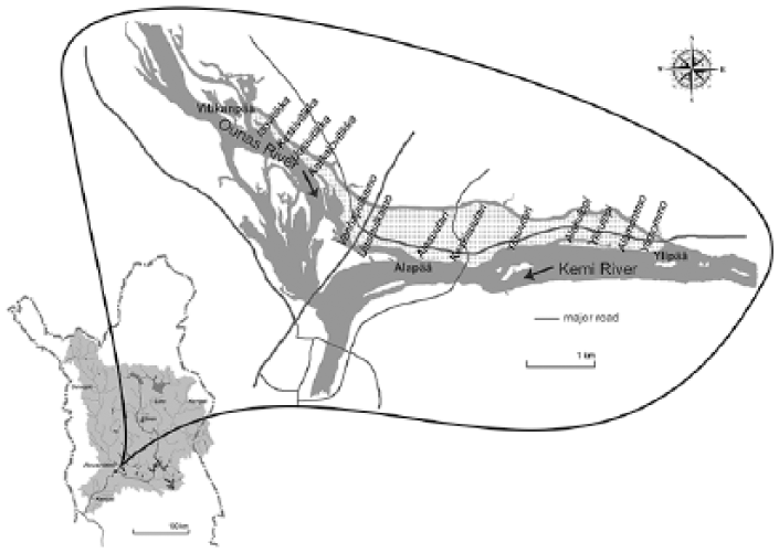
The island of Saarenkylä (dotted) between the Kemi and Ounas Rivers and a narrow river channel along the northeast, with the names of established families and farms. The overview map shows the Kemi River catchment with major watercourses; Saarenkylä is today part of Rovaniemi.
I first learned about this through a series of conversations and trips on foot and by car with Erkki, who had grown up on the island before becoming a teacher in a nearby village. As a local history enthusiast, Erkki was not only keen that I should understand how the river landscape had been like only a generation or two ago, but he also ordered me to read a collection of essays on the village’s past that he had been involved in publishing. 45
Sitting over a map of the island, Erkki explained that its tip extending upstream into the Kemi River is called Ylipää (‘Upper Head’) and the flank facing downstream called Alapää (‘Lower Head’). The family associated with the ‘Upper Head’ has been called Mommo, or Saarenpää (‘Island-head’), since around the year 1600. 46 During the mid-19th century, the Mommo farm was divided in two, which have since been called Ylimommo (‘Upper Mommo’) and Alamommo (‘Lower Mommo’). Until recently, the families occupying these farmsteads had the same last names as the houses, Erkki remembered.
The next farms downstream from the Mommos have been those of Ylikulppi and Alakulppi (‘Upper-’ and ‘Lower Kulppi’), and families with respective names still lived there in 2008. Still further downstream are the homesteads of Ylisuutari, Keskisuutari and Alasuutari (‘Upper-’, ‘Central-’ and ‘Lower Shoemaker’). The occupants of the ‘Central Shoemaker’ farm have changed their last name a few times during the 20th century, but the place continues to be called Keskisuutari.
Erkki’s family name was Alasuutari, and on one of our village tours, we stopped by in the old farmstead, where we met his brother, sister and sister-in-law. The latter were proud of the more than 150-year-old house high on the riverbank, one of the few in the area to have survived the Second World War, and with great access to the river in which they enjoyed boating and fishing. It was only a few years ago that they had entirely stopped farming and sold most of their land, together with the majority of other farms on the island. During the past 15 years, their former hay meadows and potato fields have become occupied by suburban detached houses that make the Alasuutari farmstead and its contemporaries stick out as old-fashioned remnants of a past era.
Erkki thought that many new residents probably do not know much about the face of the village a few decades ago. The local history that Erkki had been involved in collating, however, provides more insights. For instance, a list of Saarenkylä families receiving land under the Finnish land reform (Isojako) that was realised in Rovaniemi in the late 19th century includes, apart from those mentioned above, the following names: Ylioikarainen and Alaoikarainen, Yliraudanjoki and Alaraudanjoki, Ylianttila and Ala-anttila, and Poikela, Keskipoikela and Alapoikela. 47 These names, just as the above, referred to both people and real estate; farm or house name and family name were identical.
Whereas distinguishing families and farms according to the river’s flow appears to have been a rather straightforward pattern, a number of place names on the island also suggest that this principle did not work everywhere. The other end of the island is called Vitikanpää (‘Vitikka’s Head’), according to the Vitikka family and farm associated with this part of the island. In a registry from the late 19th century, 48 this group was subdivided into Isovitikka, Keskivitikka, Uusivitikka and Korkalovitikka (‘Large-’, ‘Central-’, ‘New-’ and ‘Korkalo-Vitikka’). That there are no ‘upper’ or ‘lower’ groups in this extended family illustrates that the flow of the river was not the only principle by which to create names for family and farm divisions. In fact, close to the island’s ‘Lower Head’ (Alapää), where the Kemi and Ounas Rivers meet, the Pulkamo extended family and farm names do not make any reference to the river at all. Instead of ‘upper’ and ‘lower’, the two farmsteads are called Vanhapulkamo and Uusipulkamo (‘Old-’ and ‘New Pulkamo’). An indication of the river’s flow can only be meaningfully part of place and family names when it is clearly discernible and matters for the practices of river dwellers. At the confluence of the two major rivers, all directions along the bank are ‘upstream’, and the precise course of the currents fluctuates with the relative amounts of discharge from both rivers.
Similarly, in the area dominated by the large expanse of the Suoli Lake system in the east of the catchment, no long-established families have last names that indicate ‘up’ or ‘down’ as I learned during visits and interviews there. Places around the lakes are distinguished according to locally more salient characteristics – such as particular bays or peninsulas – but not according to the current, which most often is hardly discernible at all and has never had any bearings on the activities of the lake shore inhabitants.
Riverbank names, conversely, often indicate the location of one family or place relative to another, and are thereby strictly relational. Alapoikela is further downstream than other Poikela groups, and Keskisuutari is in between its ‘upper’ and ‘lower’ extended relations. The locations themselves – by taking cues from the river – thus internalise the flow of the waters and the movement of people, fish and goods along the river. Place and family names along the Kemi River thereby bear witness to the histories of human settlement and activities and to significant features of the river or its banks. In particular, they tell of the relationship between human practices and river currents; they reflect past and present dwelling in a fluvitory, a world fundamentally influenced by water flows. Place names suggest that the perception of the water’s directionality has long been one of the central aspects of river dweller experience and structured their topology and relations.
Upstream as ‘north’, downstream as ‘south’
The Kemi River suggests not only the directions of ‘up’ and ‘down’ in the catchment basin but also an orientation in terms of north and south. For instance, I have repeatedly seen and heard the village of Oikarainen referred to as being located ‘twenty kilometres north of Rovaniemi’. While it is true that the distance from Rovaniemi to Oikarainen is about 20 km, the journey leads southeastwards along the river – not northwards. On a modern map, the river flows roughly southwestwards, with some stretches more directly southwards and others more clearly westwards, but yet others even eastwards and northwards (Figure 1). Nevertheless, for many river dwellers, the Kemi River describes a generally straight line from its headwaters in the north, to the Bothnian Bay in the south. Accordingly, and particularly along the lower third of the watercourse, river dwellers speak of an ‘eastern bank’ and a ‘western bank’, referring to the orographically left and right banks, respectively.
Given that most river dwellers speak Finnish, this is particularly interesting because linguistically it would be as easy to speak of the river as running generally from northeast to southwest, and to call the banks northwestern and southeastern, as there are primary words for northeast (koillis), southwest (lounas), northwest (luode) and southeast (kaakko) in Finnish. Calling the orographically right riverbank ‘länsi’ (west) rather than ‘luode’ (northwest) cannot therefore be explained as a mere simplification of terms.
Approaching a river as a straight line in orientation and narrative, rather than the meandering course it actually is, seems to be a widespread aspect of Oslender’s ‘aquatic space’. 49 Turning this line from a northeast–southwest course onto a north–south trajectory is more specific to the Kemi River, and this section will explore why this may be so. I shall demonstrate that it is again through practical engagement with the landscape, as well as the historical sediments of former practices, that river dwellers equate upstream on the Kemi with north and downstream with south. I will also demonstrate how the narratives contrasting upstream and downstream life contribute to the experience of northern and southern environments.
Experiencing northernness
In Finland, as well as in other parts of the northern hemisphere, ‘the North’ is commonly associated with a cold, peripheral and underdeveloped place, sparsely populated by somewhat exotic people. 50 In order to survive, the narrative has it, these people have to stick together and help each other out, for only in collaboration can they make ends meet under the tough conditions. 51 This contrasts with the image of ‘the South’ as a warm, industrialised area rich in infrastructure but rather poor in personal relations.
In terms of a modern Finnish map, however, the continua from centre to periphery, from milder to colder areas, and from urban to rural lifestyles, are not only ranged along a north–south axis but also have an east–west dimension. Throughout Northern Finland, western and southern regions share many economic, sociocultural and meteorological characteristics, just as northern and eastern areas are similar in these respects. The Finnish climate gets colder the further one moves northeast, the length of the ‘thermal growing season’ 52 shortens towards the northeast and the accumulation of snow cover over the winter increases also northeastwards. Moreover, in terms of vegetation, the east is very much like the north in Finland. Most of central Finland belongs to the ‘middle boreal zone’, which extends around the Gulf of Bothnia far into western Lapland. Northern and eastern Laplands, however, as well as most of the eastern parts of central Finland, are classified as ‘northern boreal zone’. 53
The same pattern is discernible in a number of socio-economic indicators. Maps showing the regional distribution of unemployment and areas of state development support 54 tend to have most of the economic weaknesses concentrated in northern and eastern Finland. For instance, the Council of Lapland 55 states that in 2012, the average unemployment in the coastal region of ‘Kemi-Tornio’ has been 12.5%, while average unemployment in ‘East Lapland’, around the Kemi River’s headwaters, amounted to 18.2%. That northern and eastern areas are also associated with extensive land-use, low population density, high proportion of state-owned land and limited agricultural possibilities is also reflected by the border of the Finnish reindeer herding region, which extends further south towards the east.
Historically, the coast of the Gulf of Bothnia has been integrated with the centres of political and economic power like Turku, Stockholm and Uppsala since the Middle Ages. 56 Areas further inland, however, have remained peripheral to the Swedish and Finnish states for much longer, where ‘inland’, as seen from the Finnish coast of the Gulf of Bothnia, means eastwards and northwards. The river valleys draining into the Gulf have gradually provided corridors for the expanding integration of inland areas with the centres. 57 But for a long time, while the lower reaches of these rivers were considered properly civilised lands, the rivers’ headwaters continued to be remote places, known above all as hunting and fishing grounds, as upstream ‘Laplands’.
It has been noted that historically there have been many ‘Laplands’ in northern and eastern Finland, each denoting the headwaters of a particular river that flows westwards or southwestwards into the Gulf of Bothnia. Alongside the Lapland of Kemi, there were the Laplands of Tornio, of Ii, of Oulu and probably even of Pietasaari, a town on the Bothnian coast well into the southern half of Finland. 58 The Laplands of the various catchments provided opportunities for the settlers of the lower reaches to hunt and particularly to fish, often alongside the Saami populations of these regions. Going to ‘Lapland’ thus has meant travelling upstream.
Finally, the course of the famous Lappi and Lanta Border (Lapin ja Lannan Raja), a 17th-century administrative boundary between land taxed for agriculture and non-agricultural economies, respectively, indicates how east and north have been historically lumped together. 59 Roughly describing a line parallel to the coastline of the Gulf of Bothnia, the border ran from northwest to southeast in northern Finland, making the northeast into Lappi, that is, hunters’ and reindeer herders’ terrain, and the southwest into Lanta, that is, the region of agricultural settlements.
From these various economic, sociocultural and meteorological observations, it follows that phenomenally, the ‘real north’ in Finland is the geographical northeast. The more one moves north and east – or northeast – the colder it gets and the more peripheral and sparsely populated the environment becomes. The ‘real south’, on the other hand, includes most of the Bothnian coastline, where many larger, industrialised and well-off towns are located. The course of the Kemi River is a microcosm of this relationship, with the industrialised town of Kemi at its mouth and the unemployment-ridden and depopulating municipalities of Salla and Savukoski 60 on its headwaters. Moving up the river is a journey into the cold, sparsely populated periphery; travelling down the river means going towards the mild, urban and industrialised centre. Projecting this relationship onto the North–South imaginary that I sketched above makes it obvious how ‘upstream’ on the Kemi River – although generally referring to the geographical northeast – is equated with ‘north’.
The river also embodies the distinction of an underdeveloped, peripheral and ‘wild’ north as opposed to an industrial, more densely populated and ‘urban’ south through the different flows that is has historically enabled. In particular, they include the region’s commercial and environmental history that has been described as a colonial conquest 61 at the hands of southern interest, an understanding that extends the north–south continuum all the way to Stockholm and Helsinki. One person from the Kemi’s headwaters claimed that Lapland has been drained of all its riches downriver towards the south, and later along the roads and high-voltage transmission lines that were built to make these same transport routes more efficient: first, the shamans’ drums, later gold and timber and finally also hydropower. 62 In this and similar accounts, the Kemi River becomes an icon of the unidirectional flows from resource periphery to the centres of economic and political power.
Conclusion
The Kemi River is a fundamental participant in the ‘stories-so-far’ 63 that make space in central Lapland, which for river dwellers is fluvial rather than terrestrial. It constitutes a specific kind of ‘aquatic space’, based on traditions of moving along or against the flow of the rivers, so that places are constituted not merely by what goes on in them, but as much by how they relate to other localities by way of the river’s flow. Its direction suggests which way is ‘up’ and which is ‘down’, and hence which places or persons are located ‘higher’ or ‘lower’ in the river dwellers’ geography. 64 I have shown that even the universal directions of the compass have been integrated into this sense of direction, as ‘north’ has been equated with upstream, and ‘south’ with downstream. Therefore, central Lapland is not primarily a territory but, more precisely, a ‘fluvitory’ for its inhabitants. Even though they live on solid ground, their current and historical movements along the rivers have made space in direct correspondence with water flows.
The article has suggested that the river enters into the stories that make space through people’s practical and historical experiences with its waters and hinterlands. 65 Investigating fishing, travel and transport illustrates how space-making is not an immaterial process of attaching meaning to an otherwise meaningless expanse, but grounded in the flows of the landscape, in which people align their movements to those of the water, rocks and animals, and the slopes of hills and valleys while aligning the trajectories of other humans and non-humans to those of their own practices. 66 This adds an important dimension to Ingold’s conclusion that in landscapes, ‘meaning has not been “pinned on” but is there to be “picked up” by those with eyes to see and ears to hear’, 67 where ‘to see [. . .] is a matter not of acquiring schemata for mentally constructing the environment but of acquiring the skills for direct perceptual engagement with its constituents, human and non-human, animate and inanimate’. 68
If these constituents are themselves suspended in directed flow, engaging with them through practices and narratives engenders a space that is equally directional. Specifically, traditions of movement along the Kemi River have formed particular fluvial spatial relations and sedimented them in place names and conventions of orientation. This space-making process is not complete, but is being transformed in the context of road-based travel and transport. In sum, I have argued that tracing the evolving stories that make space must not treat water flows as mere features of a territory, but attend to the fluvitorial dimensions of space. Traditions of fluvial space-making along the Kemi River can help us to rethink spatial relations as less ‘terrestocentric’ and more open to the role of rivers and water in the constitution of our worlds; they also ground these aquatic analyses in specific practices and narratives rather than issuing programmatic and blanked statements about the affordances of water for theory development. Such more specific ‘wet ontologies’ allow us to relate the fluid and solid aspects of human lives in more detail, instead of constructing or affirming binary oppositions between the wet and the dry. Finally, the directionality, if multiple and temporally emergent, of water flows and space in central Lapland also indicates that not only reach and distribution of water networks matter, but that the direction of movement is as crucial for spatial relations.
Footnotes
Acknowledgements
I am indebted to the people from Finnish Lapland who have taught me about life on the Kemi River and grateful to Cristián Simonetti and two anonymous reviewers for their help in clarifying my argument. Thank you to Frederik Weck and Vanessa Höse for lending a hand with the figure. I dedicate this article to Erkki Alasuutari (1929–2009), school teacher, local historian and river enthusiast.
Funding
The author(s) disclosed receipt of the following financial support for the research, authorship, and/or publication of this article: This article is based on research supported by Angus Pelham Burn and the Finnish Cultural Foundation (Lapland Fund and Paavo Koskinen Fund). It was written and revised during postdoctoral positions financed by the Estonian Research Council (ERMOS146 and PUT690).