



Abstract
In this article, I discuss the application of a portable global positioning system (GPS) receiver and a heart rate (HR) monitor for analyzing the fishing activities of the Roviana fisher-horticulturist population in the Solomon Islands. Each participant wore a portable GPS unit and a HR transmitter and recorder. Twelve trips relevant to fishing were recorded from departures to arrivals and analyzed in the context of time and space. The ratio of HR observed to the predicted maximal HR was the highest when subjects were fishing in the outer barrier reef drop edges, where they canoed continuously with little rest. The limitations of the HR monitor and/or GPS receiver were generally low for acquisition during diving activities, however, special precautions should be taken to minimize acquisition errors. This method is expected to contribute to a better understanding of human behavioral ecology and maritime anthropology.
Introduction
Understanding how a fishing society uses space and time for foraging activities has been a central debate in maritime anthropology or human behavioral ecology (Aswani 1997, 1998). Time allocation studies have developed such methods as (1) individual tracing; (2) observation at fixed spot; (3) random spot-check (Suda 1994); (4) time-saving spot-check (Moji and Koyama 1985); and (5) time and activity recall (Gregory and Altman 1989) for observing the society’s uses of space and time. However, an individual tracing method, which can observe exact behaviors, can cover only a limited number of individuals at a time. Observation at a fixed spot, time-saving spot-check, and time recall methods can cover a number of individuals, but the actual places have been seldom observed and their accuracy depends solely on the participants’ oral reports. The random spot-check method also requires several months to complete all observations. In addition, all these methods measure time only, not the intensity of activity. Therefore, it is necessary to find a method that can (1) cover a number of individuals at a time; (2) identify detailed activity places; (3) measure the intensity of activities; and (4) complete all observations in a relatively short time period.
Global Positioning System (GPS) receivers have recently been simplified and downsized. GPS can provide reliable location and time information and has been used in a variety of commercial and academic fields. The application of GPS has also used to record human daily activities (Maddison and Mhurchu 2009). For instance, Rodriguez et al. (2005), in their study of residents’ daily lives in a town in North Carolina, confirmed that the accuracy of a wristwatch size GPS (Foretrex 201, Garmin Ltd., Olathe, KS) was high (the average distance from the recorded points to the geodetic point was 3.02 m, and 81.1% and 99.9% of points were located within 5 m and 20 m buffers, respectively). They also scaled the intensities of the subjects’ physical activities using an accelerometer and found that participants who lived in areas with a high population density, street connectivity, and many public parks tended to engage in moderate to vigorous physical activities outdoors in their neighborhood. Umezaki et al. (2010) and Jiang (2009) also used this method to study urban dwellers in Tokyo, Japan, and agricultural societies in the Asian Pacific region. In these studies, each participant wore a wristwatch size GPS so that a number of individuals were covered.
On the other hand, human biological studies have developed a heart rate (HR) monitor method for estimating the physical activity levels and energy expenditure in subsistence societies (Leonard 2003; Spurr et al. 1988; Yamauchi 2001; Yamauchi et al. 2000). Each participant in those studies wore a compact HR recorder and transmitter, and the intensity of their activities was measured as a function of their HRs. The methods using GPS tracking and HR monitoring have already been used in analyzing children’s activities in the schoolyard in Norway (Fjørtofta et al. 2009), and Rugby players’ and beach soccer players’ performances during games (Castellano and Casamichana 2010; Cunniffe et al. 2009). Kondo and Seino (2010) also successfully recorded physical activity intensity during walks along a historical mountainous road in Japan, but this combined method has not been applied for the study of subsistence societies. The HR method is better than the accelerometer method for analyzing fishing activities because people spend a substantial time in a sitting position in dug-out canoes.
In this study, I report the application of a portable GPS receiver and a HR monitor for analyzing the fishing activities of the Roviana fisher-horticulturists in the Solomon Islands. I analyzed the intensity of physical activity, broken down by various fishing types and grounds. I also provide information on the technical limitations for fieldworkers’ future convenience in adopting this method.
Methods
Study Sites and Participants
This study was conducted in Olive village, Roviana Lagoon, the Solomon Islands. All inhabitants of the village (365 in 2005) were engaged in the shifting cultivation of tuberous crops (7.7 hours per adult per week on average) and fishing for their consumption (5.1 hours per adult per week; Furusawa 2005; Furusawa and Ohtsuka 2006). The main source of cash income (55.9% of SI $461 per household per month in average) was selling marine resources such as Nassarius shells and sea cucumbers for export. Inhabitants of Olive and neighboring villages agreed with a foreign research team to build marine-protected areas (MPAs) in their territory and have been restricted from acquiring resources in these MPAs since 2002 (Aswani and Furusawa 2007; Aswani and Hamilton 2004).
I conducted this study during a one-week period in July 2007 and did follow-up surveys in the following weeks. I had been conducting fieldwork in this area since 2001, spending more than twenty-four months in total participating and observing subsistence activities. Voluntary participants were asked to take GPS units and HR monitors when they left the settlement for subsistence activities and to bring them back when they returned. The villagers engaged in activities outside of the settlement roughly five times per week (e.g., once for fishing, twice for horticulture, and twice for communal activities). In other words, the participants returned the GPS and HR monitors to me every time they returned from trips to the settlement. I then changed the batteries and downloaded the data at night. The next day, the participants took the GPS and HR monitors again and went on other trips. When they stayed in the village, they did not wear the GPR or HR monitors. Fifty activities of thirty-eight villagers were thus recorded, and twelve activities of twelve villagers were related to fishing and marine resource collection (see Table 1 ). Each participant was also interviewed about the detailed place and activity of the day when they returned. I asked each participant about his or her age and measured his or her height and weight.
Participants and Recorded Fishing and Gathering Activities

Note: HR = health rate; GPS = global positioning system.
aConditions were classified using the proportion of abnormal values: good <10%, acceptable <40%, bad <90%, very bad 90% and more.
Data Collection Using the GPS Unit and HR Monitor
I packed both the GPS unit and HR receiver in a small (15 × 16 cm) waterproof plastic: polyethylene terephthalate (PET) electronic protection bag (Seal Line; Cascade Designs Inc, Seattle, WA). Each participant wore this bag at the waist. The Foretrex 101 (Garmin Ltd.) is a battery-driven, water-resistant, and wristwatch size GPS unit that weighs 78 g. An internal memory card provides the unit with the capacity to store 10,000 points, and two alkaline AAA batteries can run the system for approximately fifteen hours. The units were set to record the positional coordinates of their locations at five-second intervals with the Wide Area Augmentation System enabled. I downloaded recorded data, including latitude, longitude, date, and time to a personal computer using Kashmir 3D Software (Sugimoto Tomohiko, Japan). The tracks were not recorded when the GPS antenna was shaded from the satellites by houses reefs, trees, participants’ bodies, and other objects. In addition, there were potential fault tracks in the recorded data, probably because of atmospheric, satellite, and other conditions. Although there are no criteria for judging acquisition errors, I classified track records with a movement speed exceeding 40 km/hr as errors since the villagers’ walking and paddling canoes have empirically never exceeded this speed.
The HR monitoring system consisted of an electrode-belt transmitter and a wrist microcomputer receiver (S610i and Wearlink Transmitter and Cheststrap; Polar Electro, Kempele, Finland). This system was light (approximately 45 g) and did not disturb the subject’s behavior. I recorded the pulse at five-second intervals. The time of clock in each HR receiver was set with the time of the paired GPS unit with less than a one-second difference every time the record started. Therefore, the records of the GPS units and the HR monitors were able to be matched within a one- to three-second interval. I downloaded the recorded HR data to the personal computer using the Polar Precision Performance Software (Polar Electro). Some HR profiles were not analyzed due to faulty electrode contact. I recognized a HR of zero or more than 200 bpm or spikes in the record as transmission problems (Yamauchi et al. 2000, Yamauchi 2001), and classified the HR data conditions into four classes: good with <10% such problems, acceptable with 10–40% problems, bad with 40–90% problems, and very bad with more than 90% problems.
Data Analyses
I saved the downloaded GPS data in two file formats. One was .trk as an original format for the Kashmir 3D; the other was .gpx as an exchangeable format with other software. The former file format can be opened as a text file with a space delimiter in Microsoft Excel 2007. The latter format is important for analyses in other geographic information systems (GIS) software packages, such as ArcGIS, but is not analyzed in this article. I opened the downloaded HR data in a Polar Precision Performance Software program and simply copied and pasted and combined them with the GPS data in an Excel spreadsheet (Yamazaki 2006).
Detailed analyses were made only for fishing because the data acquisition was bad in regard to the shell collection activities. I viewed and interpreted track data, which were opened on a layer of Landsat Enhanced Thematic Mapper Plus (ETM)+ image (acquired December 1, 2002; NASA Landsat Program, USGS, Sioux Falls, IA) and a digital elevation data (Shuttle Radar Topography Mission) available at Global Land Cover Facility of the University of Maryland, one by one on Kashmir 3D. The GPS record provided the location and the moving speed forward and backward. In my previous fieldwork, I had identified the locations that the villagers used in fishing and their activities there, so I was able to interpret the precise locations and activities based on the GPS record in tandem with the participants’ detailed reports. The Olive villagers’ fishing activities included foraging in inner lagoon reefs (sagauru in local Roviana), outer barrier reef drop edges (vuragare), lagoon passages (holapana), and open ocean (kolo lamana), and transport by canoeing (vose) between the settlement and these fishing points (Aswani 1997). I therefore classified the GPS tracks into canoeing in inner lagoon, canoeing in the open ocean, fishing, including both angling and trolling, in inner lagoon, passage, outer reef drop edges, and open ocean. Other activities, such as preparing canoes and fishing gears, walking in the settlement and/or barrier islands, and engaging in gardening and/or forest material collection, were excluded from the detailed analyses.
In this study, I used a proportion of the HR to the maximal HR (%HRmax) as an indicator of activity intensity (Achten and Jeukendrup 2003), where the maximal HR (HRmax) was predicted by a formula provided by Polar based on resting HR, HR variability at rest, age, gender, height, and body weight (Hannula et al. 2000).
All statistical analyses were made using the SAS 9.2 (SAS Institute, Cary, NC); 99% confidence intervals were calculated for the averages of %HRmax.
Results and Discussion
Twelve trips relevant to fishing activities were recorded with 69,464 location-HR points (Table 1); participants A through F engaged mainly in fishing while G through L in collection of shells. As shown in the table, males engaged in angling, trolling, and other kinds of fishing, while females participated in collecting marine resources. Both GPS units and HR monitors were able to record all activities ranging from two hours and fifty-two minutes and twelve hours and thirty-two minutes. Although the departure and returning times varied, these digital recording techniques did not miss any of the observations. However, activities under shades of mangrove trees and diving in sea caused a high proportion of errors in GPS units. The HR records were also good during angling and trolling, but very bad during shell collection, which was accompanied by diving in the salt water (approximately 1.5 m deep), probably because the water interrupted transmission between the HR monitors at the breast position and the HR recorders at the waist position when the participants were underwater.
Figure 1 shows the locations of the twelve recorded trips. The villagers angled (habu tutusa in Roviana) in the inner coral reefs and a lagoon passage. They trolled (karu mae) in the open ocean for catching bonitos, in the inner lagoon mainly for trevallies, and in the outer barrier reef drop edges for various types of large fish (e.g., barracudas). Trolling in the open ocean used a wide area of ocean. The villagers insisted that the Nassarius shells are abundant in shallow inner lagoon sand of far Konggu Kalena Bay, while sea cucumbers are available in the shallow sea closer to the settlement and shells for consumption in mangroves. In addition, the villagers frequently combined two or more activities in one trip. For example, participant B went fishing in an inner lagoon but also visited his garden and forest for firewood collection. Participant D trolled in the open ocean and then angled and trolled in the outer barrier reef drop edges.
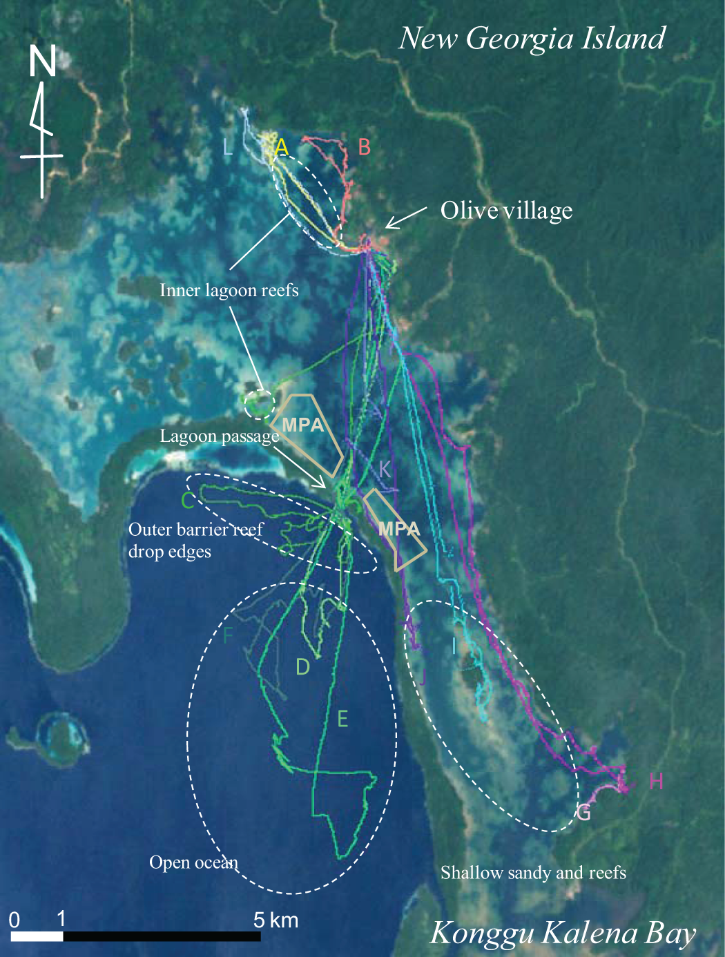
Twelve fishing trips (A–L) tracked by portable global positioning system (GPS) units. The color image is available at URL: asafas.kyoto-u.ac.jp/furusawa/figFM.html
Figure 2 shows an example (participant D) of the combined data of a GPS and HR monitor. A high HR emerged periodically in the open ocean, thus suggesting trolling and catching fish interrupted by floating. The high HR continued at the outer barrier reef drop edges. It was obvious that the HR varied even in one place or in one activity, for instance, the HR for canoeing in the inner lagoon varied between going from and coming to the settlement; this was probably due to canoeing at high speed when going out and at low speed when coming back.

Finally, Table 2 shows the averages of the %HRmax (with 99% confidence intervals) broken down by place and activity. Shell collection activities (i.e., participants D through L) were excluded due to the low acquisition of HR and/or GPS data. The intensity of activity was the highest in fishing in the outer barrier reef drop edges (60.4% of HRmax). This is probably because the villagers troll in this area paddling continuously with little rest while they usually float waiting to catch fish in the inner reefs, the lagoon passage, and the open ocean. Neither transport by canoeing nor other fishing methods showed a large HR increase (40–50% only). Generally, the energy expenditure rarely differed from the basic metabolic rate if the %HRmax was <50%; for instance, 60–70% of HRmax is recognized as a level of low fitness in aerobic exercise and/or interval rest in sports (American College of Sports Science 1995; Borresen and Lambert 2009; Cunniffe et al. 2009). Therefore, the results are interpreted as indicating that the villagers exerted energy similar to that expended during participation in a low fitness level activity while they were fishing in the outer barrier reef drop edges but seldom expended significant energy in other activities.
Intensity of Activities (Mean [99% Confidence Limit]), Broken Down by Place and Activity

aFishing included both angling and trolling.
cThe unit of record is a matched pair of GPS track point and the HR value (both recorded at five-second intervals).
General Discussion and Conclusions
This is the first study that combined a GPS unit and a HR monitor for observing the foraging activities associated with fishing. The limitations of the study design included the small sample size. Therefore, I discuss mainly the methodological aspects rather than generalization of the findings.
I found the following technical limitations: (1) the HR monitor was generally low in acquisition during diving activities and (2) the GPS receiver did not function under shade caused by houses, forests (including mangroves), and water. On the other hand, the advantages of my method were that (1) all fishing activities from departures to arrivals were recorded in five-second intervals for twelve hours and thirty-two minutes in maximum; (2) numerous simultaneous observations were possible; and (3) the variety in physical activities during one fishing trip were captured. In addition, the GPS and the HR data were combined in Kashmir 3D, which is a free software package that shows a high performance and is used in various fields of research (Fukita and Nishimura 2005; Matsuoka Takumi, and Kawahara 2007), although these analyses were possible in commercial GIS software such as ArcGIS and Map Source. The usefulness of the free software may expand the use of GPS for field studies in various academic disciplines.
Based on my prior background in the field, I was able to observe the villagers’ time and space uses in greater detail than the conventional observation and/or interview surveys in time-allocation studies. Thus, the knowledge from this study will increase our understanding of human behavior. For example, using the conventional recall method, Aswani (1997) had estimated that fishes were caught the most efficiently in the outer reef drop edges (13.2 MJ of edible portion of fishes were caught per one hour of fishing), followed by the inner reef (10.1) and passage (5.1) on average in Roviana-speaking communities in July, although no data were shown for the open ocean. His data, in tandem with my data collected in July, suggest that more physical intensity was invested for greater gains, because the highest intensity was spent in outer reef drop edges, followed by the inner reef, and then the passage in this study (Table 2).
Using this method, it is also possible to predict changes in physical burdens due to social and environmental changes. For example, the villagers are now required to avoid fishing in the MPAs and must go to the fishing grounds farther away from the village (Figure 1). As shown in Table 2, however, the burden of canoeing was relatively limited, and this change in location (i.e., the need for an extended time for canoeing) might have slightly increased the villagers’ energy expenditure, but it did not have any major impact on the villagers. My method can potentially be applied for studying other subsistence activities such as hunting and gathering and horticulture, but a limitation remains for gathering data in locations under shade. Therefore, GPS units with higher sensitivities would be needed. It should be noted that the Garmin Foretrex 301, which is a new version of the battery-drive watch-type GPS unit with a higher receiver sensitivity, is now available. This unit should therefore be examined for acquisition accuracy.
Although several limitations still need to be overcome, utilization of the portable GPS and the HR monitor make it possible to analyze space and time use in fishing activities, which will contribute to a better understanding of human behavioral ecology.
Footnotes
Acknowledgments
I thank all the people of Olive village and other Roviana people for their participation and assistance. He is also grateful to Dr. Taro Yamauchi (Hokkaido University), Dr. Jiang Hong Wei (Research Institute for Humanity and Nature), and Dr. Masahiro Umezaki (University of Tokyo) for their help and guidance in using the HR monitors and GPS units.
The author declared no potential conflicts of interest with respect to the research, authorship, and/or publication of this article.
This study was supported by the Ministry of Education, Culture, Sports, Science and Technology (MEXT) of Japan as a KAKENHI Grant-in-Aid for Young Scientists.