
Abstract
Background:
Visceral leishmaniasis (VL) is a vector-borne zoonotic disease that remains endemic and poses an ongoing public health concern in western and central China. In recent years, several areas in Shaanxi Province have reported a resurgence of VL. This highlights the need for spatial risk assessments under current and future climatic conditions.
Methods:
This study employed the maximum entropy (MaxEnt) ecological niche modeling approach to predict the potential distribution of VL in Shaanxi Province. Historical VL case report data from 2005 to 2024 were integrated with environmental, climatic, and socioeconomic variables to identify key contributing factors and assess both current risk areas and projected future VL distributions under four Shared Socioeconomic Pathways (SSPs) across four future periods in the model.
Results:
The MaxEnt model showed good performance, with the area under the receiver operating characteristic curve values of 0.902 for the training data and 0.862 for the testing data. The most important contributing factors were annual mean temperature, mean temperature of the warmest quarter, and gross domestic product to VL suitability distribution. Under the current climatic conditions, the potential risk area accounted for approximately 25.28% of Shaanxi Province, with 0.97% classified as high-risk regions. These risk areas were primarily located in Hancheng, Weinan, and Shangluo City, Shaanxi Province. Under future climate scenarios, especially the high-emission pathway, high-risk regions are projected to expand significantly, particularly in northern Shaanxi.
Conclusions:
This study identified the influence of climatic, environmental, and socioeconomic factors on the distribution of VL in Shaanxi Province and revealed the substantial expansion of ecologically suitable areas under future climate change. The risk maps and ecological insights generated in the study can assist public health authorities in optimizing vector surveillance, region-specific surveillance, early warning, and targeted control efforts, particularly in the context of climate change.
Introduction
Leishmaniasis is a zoonotic vector-borne disease with a complex transmission cycle involving a wide variety of parasite species, animal reservoirs, and sandfly vectors. Visceral leishmaniasis (VL), also known as kala-azar, is transmitted through the bite of infected female phlebotomine sandflies. It remains a major public health concern in endemic regions, with an estimated 50,000 to 90,000 new cases reported globally each year (WHO, 2023). In China, VL infection is generally classified into three major forms: anthroponotic visceral leishmaniasis (AVL) caused by Leishmania donovani; desert-type zoonotic visceral leishmaniasis (DT-ZVL); and mountain-type zoonotic visceral leishmaniasis (MT-ZVL), both of which are caused by L. infantum (Liu et al., 2023; Lun et al., 2015). While AVL and DT-ZVL are predominantly endemic in Xinjiang Province, MT-ZVL is mainly prevalent in the marginal areas of the Loess Plateau, including Gansu, Sichuan, Shanxi, and Shaanxi Provinces (Guan et al., 2021; Zhou et al., 2020b). These three types differ significantly in their ecological characteristics, including landscape settings, vector species, and reservoir hosts (Guan et al., 2016).
Although VL was effectively controlled in China in the early 1980s, recent years have seen a resurgence, particularly for MT-ZVL (Wang et al., 2022), because of rapid economic development, environmental changes, and increased human mobility. Shaanxi Province remains one of the most affected provinces, with periodic resurgences reported in historically endemic counties, including Huazhou and Linwei Counties of Weinan Prefecture reported reemergent cases in 2018 (Zhou et al., 2020a), and Chengcheng County experienced a rebound in 2023 (Zhou et al., 2023). Despite ongoing prevention efforts, these resurgences highlight gaps in current surveillance and control strategies. Existing measures, such as vector monitoring, source management, and case detection, require enhanced spatial precision. There remains a need for data-driven tools that can predict high-risk areas and guide interventions.
Ecological niche modeling (ENM) has been widely used to predict the potential geographical distribution of infectious diseases by integrating climatic, topographic, and socioeconomic variables. It supports the identification of high-risk areas and environmental drivers of disease transmission (Artun, 2019; Yu et al., 2023). Among the available ENM approaches, the maximum entropy (MaxEnt) algorithm is one of the most widely applied and validated models for VL. Previous studies in Turkey (Artun, 2019), Iran (Charrahy et al., 2022), and China (Gao et al., 2018) have demonstrated its good predictive performance, particularly when only presence data are available. Therefore, we employed the MaxEnt model to estimate the ecological suitability of VL in Shaanxi Province under current and future climatic conditions. Specifically, we aimed to evaluate the current distribution of VL risk, identify key environmental and climatic factors, and predict changes in VL-suitable areas under different future climate scenarios to assist local public health authorities in developing region-specific prevention and control strategies and adapting to long-term climate-driven shifts in disease risk.
Methods
Study area
Shaanxi Province is located in north-central China, spanning 105°29′E to 111°15′E and 31°42′N to 39°35′N (Fig. 1). It covers an area of approximately 205,800 km2 and, by the end of 2024, had a permanent population of 39.53 million. Administratively, the province includes 10 prefecture-level cities, 31 districts, 7 county-level cities, and 69 counties. Topographically, Shaanxi features diverse landforms, plateaus, plains, mountains, and basins. It is generally divided into three natural regions: the northern Loess Plateau, central Guanzhong Plain, and southern Qinba mountainous area. Shaanxi spans three climate zones. Northern Shaanxi lies in a semiarid temperate zone, central Shaanxi lies in a warm temperate semihumid zone, and southern Shaanxi lies in a humid subtropical zone. The province’s average annual temperature is 13.7°C, with the regional variation ranging from 8°C to 16°C. The annual precipitation varies from 340 to 1,240 mm.

Ecological suitability of VL in Shaanxi Province predicted using the MaxEnt model.
Data collection and environmental variable screening
A total of 335 VL cases reported in Shaanxi Province between January 1, 2005, and December 31, 2024, and were obtained from the Infectious Disease Surveillance Module of the National Notifiable Disease Reporting System. Each case record provided sufficient residential address information to confirm the geographic coordinates at the village-level using Google Maps. Only indigenous cases were included in the analysis, where imported and unclassified infections were excluded. To reduce spatial sampling bias and minimize spatial autocorrelation, occurrence points were spatially thinned to one record per 1-km2 grid cell (matching the resolution of the environmental variables) using the R package spThin, resulting in a final dataset of 261 unique occurrence points.
Environmental, climatic, topographic, and socioeconomic variables potentially associated with the risk of VL infection were included in the analysis (Table 1). Nineteen bioclimatic variables (BIO1–BIO19) were downloaded from the WorldClim v2.1 database for the baseline period (1970–2000) and four future periods (2021–2040, 2041–2060, 2061–2080, and 2081–2100) under four Shared Socioeconomic Pathways (SSPs) (SSP126, SSP245, SSP370, and SSP585) using the BCC-CSM2-MR general circulation model. Additional variables, including the normalized difference vegetation index (NDVI), land-use type, vegetation cover, population density, gross domestic product (GDP), elevation, and land form types, were obtained from the Resource and Environment Science and Data Center (https://www.resdc.cn/). All raster layers were projected into the WGS 1984 coordinate system and resampled at a spatial resolution of 1 km2. Variables were converted into the ASCII raster format using SuperMap 8C and R software (version 4.2.2).
Explanation of Bioclimatic and Environmental Variables and Their Contribution to the MaxEnt Model
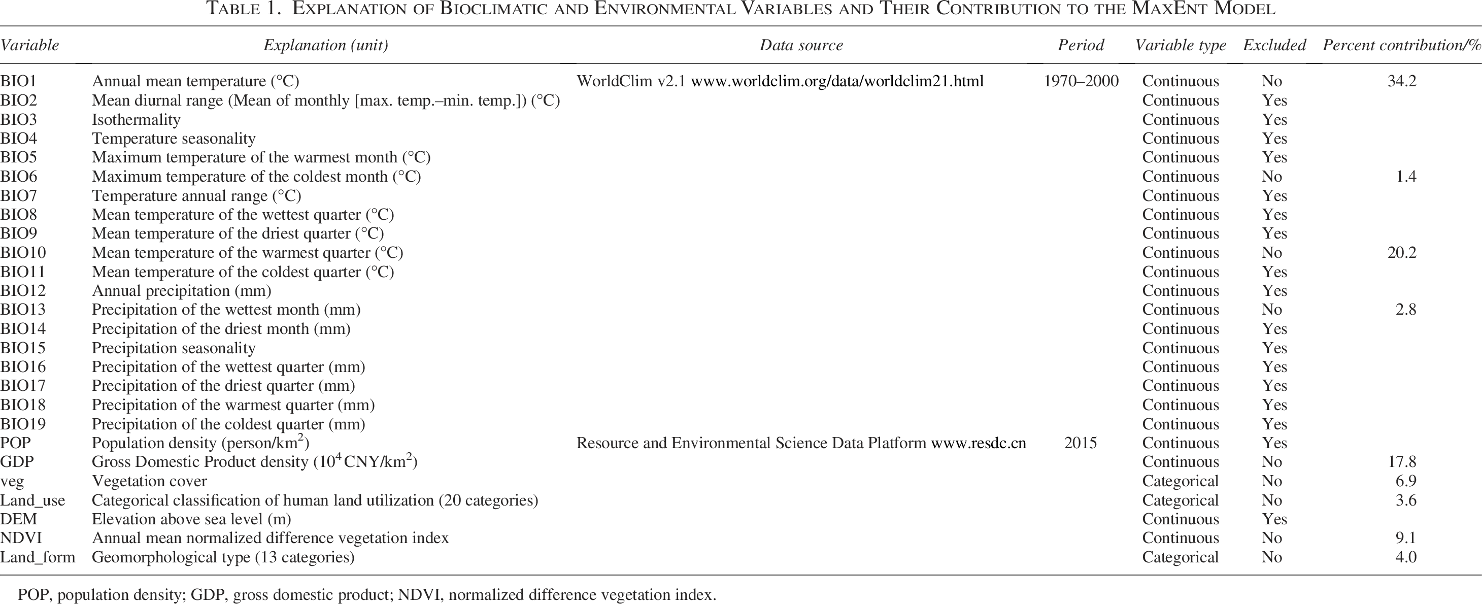
POP, population density; GDP, gross domestic product; NDVI, normalized difference vegetation index.
First, the preliminary MaxEnt model was developed based on all 26 bioclimatic and soi-environment variables to evaluate the contribution of each variable using the Jackknife method. Subsequently, the relationships between different variables were tested using Spearman correlation analysis (Supplementary Fig. S1), and pairs of variables with |r| ≥ 0.8 were considered highly correlated. For each pair, only variables with higher contributions in the preliminary model were retained for the final modeling.
Model establishment, optimization, and evaluation
We employed the MaxEnt algorithm (Phillips et al., 2006), a presence-only machine learning method, to model the ecological niches and predict the potential geographical distributions of VL based on known occurrence locations and associated environmental variables. The model was run using MaxEnt software (version 3.4.4). The 261 presence records were randomly assigned as training (75%) and testing (25%) subsets to calibrate and evaluate model performance, respectively. Other major parameters were set as follows: 10 replicates in the bootstrap mode, a maximum of 10,000 background points, 10,000 maximum iterations, and logistic output formats.
The R package ENMeval was used to optimize the feature class (FC) and regularization multiplier (RM) in the MaxEnt model. The feature combination of the model, including linear-L, quadratic-Q, hinge-H, product-P, and threshold-T, and regularization multiplier values were tested from 0.5 to 5, with each interval of 0.5. The final model was selected based on delta AICc values of <2 and statistically significant omission rates of <0.05.
Classification of suitable regions and reliability test of the model
The Maximum Test Sensitivity Plus Specificity (MTSPS) threshold was used to classify areas as suitable or unsuitable for the distribution of VL occurrence. Areas with suitability scores below the MTSPS threshold were classified as nonendemic, whereas areas with scores above this threshold were subdivided into low-, moderate-, and high-risk zones using equal-interval classification in Super 8C. Model accuracy was assessed using the area under the receiver operating characteristic curve (AUC), where AUC ranges from 0 to 1, with a value of >0.8 indicating the high performance of the model (Gao and Cao, 2019), and a value of 0.5 indicating that the model was not better than random chance. The Jackknife test was performed to evaluate the relative contribution of each predictor variable to the model.
Analysis of potential future risk
The suitability of the future VL environmental distribution was projected for four periods (2021–2040, 2041–2060, 2061–2080, and 2081–2100) under four SSP scenarios (SSP126, SSP245, SSP370, and SSP585) using the BCC-CSM2-MR climate model (Wu et al., 2019). The MaxEnt model was applied to estimate the potential expansion of VL risk zones in future climate scenarios.
Ethical approval and consent to participate
This study was reviewed by the Institutional Research Ethics Community of the Shaanxi Center for Disease Control and Prevention (2025-002-02). The study was conducted in accordance with the Declaration of Helsinki, and all methods were performed in accordance with the guidelines and regulations of the Constitution of the Shaanxi Center for Disease Control and Prevention Ethics Committee.
Results
Analysis of model accuracy and classification of suitable regions
Model optimization identified the optimal FC as LQHPT and RM as 1.5, which together minimized model overfitting while ensuring sufficient model complexity (Supplementary Table S1). The final model demonstrated good performance, with an average training AUC of 0.902 (range: 0.894–0.909) and an average test AUC of 0.862 (range: 0.831–0.888), indicating a high level of accuracy in predicting the potential distribution suitability of VL in Shaanxi Province. Based on an MTSPS of 0.2563, areas were classified as follows: unsuitable (0–0.2563), low risk (0.2564–0.4873), moderate risk (0.4874–0.7183), and high risk (0.7184–1.0000).
Contribution of environmental variables
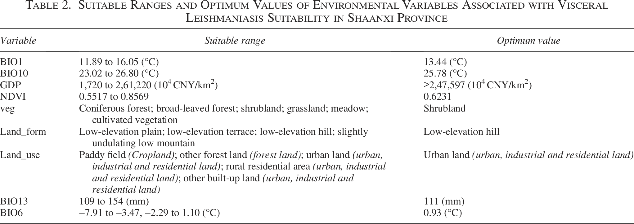
The final model incorporated five climatic variables, four environmental variables, and one socioeconomic variable: annual mean temperature (BIO1), maximum temperature of the coldest month (BIO6), mean temperature of the warmest quarter (BIO10), precipitation of the wettest month (BIO13), NDVI, land-use type, vegetation cover, landform type, and GDP. The Jackknife analysis (Table 1) indicated that among all variables, BIO1, BIO10, and GDP were the key factors affecting the distribution of VL, with the contributions of 34.2%, 20.2%, and 17.8%, respectively. Second, NDVI and veg contributed 9.1% and 6.9%, respectively. Other factors contributed to <5% of the variance. Table 2 summarizes the suitable environmental ranges and optimum values of the selected variables. The response curves (Supplementary Fig. S2) showed that suitability increased with rising temperatures for both the annual mean temperature and the mean temperature of the warmest quarter. Specifically, the predicted probability of VL presence exceeded 0.5 when BIO1 was above 11.89°C and BIO10 was above 23°C. GDP exhibited a continuous positive association with VL suitability across the examined range, with suitability increasing markedly beyond 1,720 × 104 CNY/km2.
Suitable Ranges and Optimum Values of Environmental Variables Associated with Visceral Leishmaniasis Suitability in Shaanxi Province
Current potential risk of VL in Shaanxi province
Under the current climatic conditions, the potential risk area for VL in Shaanxi Province covers approximately 25.28% of the total area (52,033 km2), comprising 0.97% (2,005 km2) classified as high risk, 6.31% (12,992 km2) as moderate risk, and 18.00% (37,036 km2) as low risk (Fig. 1). High-risk areas were identified mainly in Hancheng City, where >40% of the area was classified as high risk. In all other cities, the high-risk areas were <5%. The total risk area in Hancheng accounted for approximately 80% of the city’s area, followed by Weinan at approximately 65%. In contrast, northern cities such as Yulin and Yan’an had a lower risk, with the total risk areas of 5.68% and 16.58%, respectively.
Future potential risk of VL in Shaanxi province
The potential distribution of VL across four future periods (2021–2040, 2041–2060, 2061–2080, and 2081–2100) was projected using the MaxEnt model under the four SSP scenarios. For SSP126, both the total risk area and high-risk regions showed an overall increasing trend in the first two periods, followed by a relatively stable pattern in the later periods. In contrast, the total risk area and high-risk regions under SSP245, SSP370, and SSP585 exhibited consistent upward trends across all four periods. A comparative summary of the projected risk areas under different SSPs and periods is presented in Figure 2. The model projections indicated the spatial expansion of both the total and high-risk areas in several regions under future climate scenarios. In Hancheng, the total risk area remained >90% across all periods, and the high-risk area was often >50%. Notably, risk areas in northern prefectures, such as Yulin and Yan’an, increase over time, becoming similar to Hancheng in some scenarios, especially under SSP245, SSP370, and SSP585 (Fig. 3).
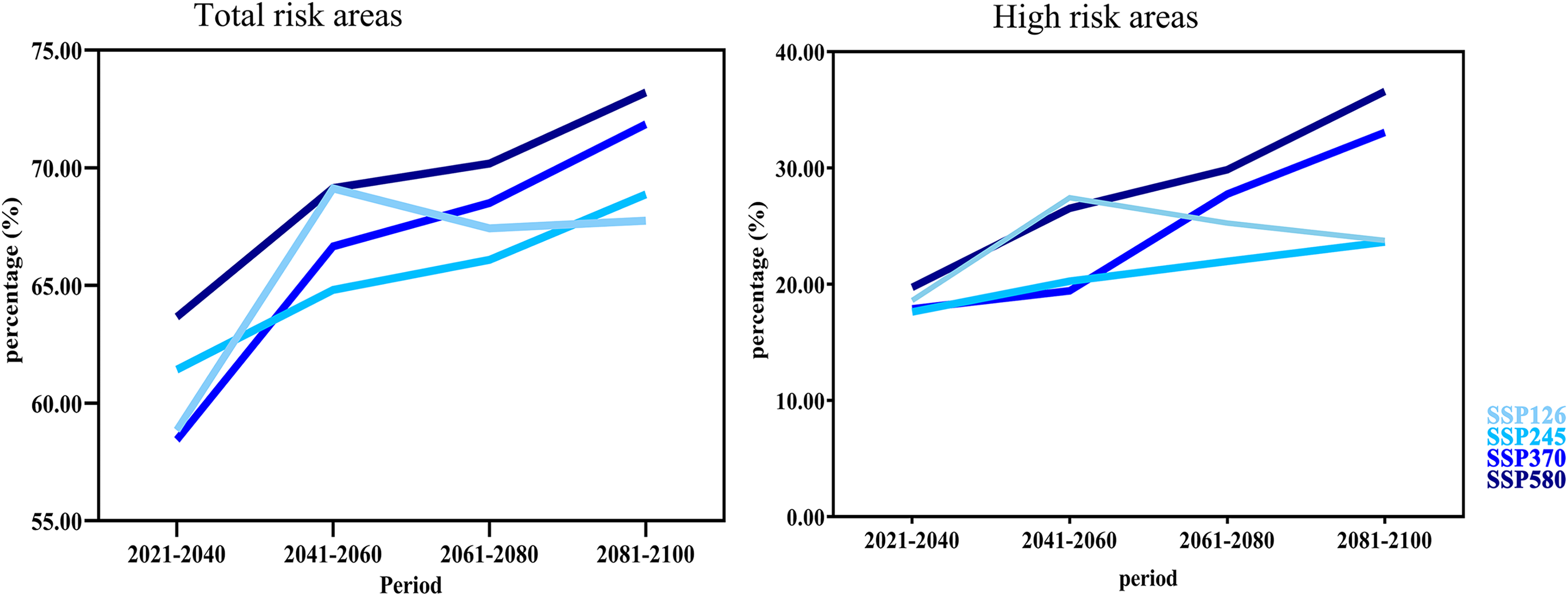
Potential total area and high-risk area for VL in Shaanxi Province under different Shared Socioeconomic Pathway scenarios (SSP126, SSP245, SSP370, and SSP585) of different climate scenarios in future periods (2021–2040, 2041–2060, 2061–2080, and 2081–2100) of the 21st century. The y-axis represents the percentage of areas for VL divided by the total area of Shaanxi Province of China.

Proportion of total and high-risk areas for visceral leishmaniasis in the cities of Shaanxi Province under SSP126, SSP245, SSP370, and SSP585 climate scenarios across four future periods (2021–2040, 2041–2060, 2061–2080, and 2081–2100).
Discussion
This study represents the first attempt to apply ENM using long-term case surveillance data to investigate the geographical distribution of VL in Shaanxi Province. The MaxEnt model performed well, with an average test AUC of 0.806, and reliably identified risk regions under the current climatic conditions. Both climatic and socioeconomic factors were found to significantly contribute to shaping the VL distribution. Projections under future climate scenarios suggest the potential geographical expansion of ecologically suitable areas for VL in the coming decades. These findings provide valuable evidence for improving regional control strategies and enhancing early warning systems for VL in both endemic and emerging-risk areas.
The current distribution of VL in Shaanxi Province is closely linked to the ecological suitability of the phlebotomine sandfly vector. Landscape transformation, demographic shifts including rural–urban migration and population growth, and evolving climatic conditions have contributed to the geographical expansion of sandfly habitats, driving VL re-emergence in endemic regions (Charrahy et al., 2022; Gao et al., 2020). Our model results confirmed that temperature-related factors have a strong influence on VL transmission (Gao et al., 2020; Medenica et al., 2023; Xue et al., 2021), with the annual mean temperature and the mean temperature of the warmest quarter identified as the dominant distribution predictors. Although previous studies from Xinjiang, China, and Iran reported similar findings, the underlying mechanisms may differ due to variations in vector species, host animals, and local environments. The relationship between temperature and VL suitability likely reflects the general effects of temperature on sandfly survival, activity, and breeding. Moderate increases in temperature can help vector development and enlarge VL risk areas; however, high temperatures may limit their survival.
In addition to climatic variables, GDP made a substantial contribution to the ecological suitability of VL in Shaanxi Province. Although higher economic development is generally associated with improved health outcomes, the positive relationship between GDP and VL suitability observed in this study may reflect the indirect ecological effects of land-use changes, infrastructure expansion, and increased domestic dog density in peri-urban areas rather than direct socioeconomic influences. Similar patterns between economic development and VL risk have also been observed in other endemic regions (Do Socorro Carvalho Miranda et al., 2022).
The present study also found that vegetation-related factors contributed moderately to the predicted VL distribution. Previous research has reported strong associations between sandfly habitats and specific vegetation types, particularly shrubland and grassland areas (Gao et al., 2020). In this study, the response curve for NDVI showed a suitable range of 0.55 to 0.86, with an optimum value of approximately 0.62, corresponding well to the NDVI values typical for shrubland and grassland ecosystems (Xue et al., 2021). Similarly, shrublands were identified as the most suitable vegetation cover category in the model. These findings suggest that stable vegetative microhabitats may support sandfly populations and play a role in maintaining local transmission cycles in certain regions of Shaanxi Province.
The modeled spatial pattern of VL risk under the current climatic conditions closely matched epidemiological surveillance data from Shaanxi Province from 2005 to 2024. The cities of Hancheng, Weinan, and Shangluo, which reported the highest number of VL cases during this period, were also identified by the MaxEnt model as having extensive high-risk and total risk areas, with Hancheng being particularly prominent. This consistency supports the effectiveness of the model in capturing the current endemic patterns and reinforces the ecological relevance of the selected predictors. Under future climate scenarios, the model revealed the notable expansion of suitable areas for VL transmission, especially in northern regions such as Yulin, Yan’an, and Tongchuan. This trend was the most pronounced under the SSP585 scenario for the 2081–2100 period, with the high-risk area projected to increase from 0.97% to 38.79% of the province’s total area. These shifts are likely driven by warming trends and altered precipitation patterns, which enhance environmental suitability in currently marginal regions. Notably, such changes are consistent with earlier research showing that VL risk tends to increase with rising temperatures up to a threshold, beyond which the transmission potential may decline (Li and Zheng, 2019; Medenica et al., 2023). This temperature-related shift may explain the upward spread of at-risk areas to higher latitudes and elevations over time. These results highlight the importance of incorporating climate projections into disease prevention strategies and provide a scientific basis for enhancing early warning systems and public health preparedness.
Because VL is a vector-borne zoonotic disease, its transmission is fundamentally shaped by the ecological niche of its sandfly vectors. Although this study did not include direct data on sandfly distribution, the key climatic variables identified in the model, particularly those related to temperature, are well-established as important determinants of sandfly survival and activity. Thus, the model outputs can be considered as a reasonable ecological proxy for vector presence and provide meaningful insights for VL risk mapping and public health planning.
Conclusions
This study developed a predictive model for the potential distribution of VL in Shaanxi Province using historical case data and environmental, climatic, and socioeconomic variables within the MaxEnt modeling framework. The model identified current high-risk areas, particularly in Hancheng, Weinan, and Shangluo, and revealed the influence of climatic, ecological, and socioeconomic factors on the distribution of VL. Under future climate scenarios, the potential risk areas for VL are projected to expand, especially in northern Shaanxi. These findings provide evidence for the spatial risk of VL under both current and future climate scenarios in Shaanxi Province and support enhanced regional disease surveillance, early warning, and the development of targeted prevention strategies.
Authors’ Contributions
X.L. participated in data collection, data analysis, and article writing. Y.N. participated in data analysis. L.Z. participated in data collection. M.Z. participated in data collection, data analysis, and article writing. M.Z. and Y.Z. revised the article and were responsible for the quality control of the study. All authors have read and approved the final article.
Footnotes
Author Disclosure Statement
No competing financial interests exist.
Funding Information
This work was supported by the 2024 Public Health Talent Development Support Program and the Sanqin Talents Special Support Plan—Provincial First-Class Team Project.
Supplemental Material
Supplemental Material
Supplemental Material
References
Supplementary Material
Please find the following supplemental material available below.
For Open Access articles published under a Creative Commons License, all supplemental material carries the same license as the article it is associated with.
For non-Open Access articles published, all supplemental material carries a non-exclusive license, and permission requests for re-use of supplemental material or any part of supplemental material shall be sent directly to the copyright owner as specified in the copyright notice associated with the article.