
Abstract
In California, as in other parts of the country, freeway construction fueled decentralization and suburbanization. Using archival research, census data, and interviews with community members this paper explores how freeway construction and urban renewal together reshaped Sacramento’s landscape. The construction of US-50 and SR-99 through the city created economic and social disparities in Oak Park, a predominantly African American neighborhood. Construction of I-5 on the west end of the city contributed to displacement of Japanese Americans and several other communities of color. The legacy of freeway building combined with other policies continues to disproportionately impact communities of color in Sacramento.
Keywords
Introduction
Freeway construction in the U.S. has played a significant role over the last seven decades in shaping urban landscapes, improving regional mobility, and promoting economic growth. Early visions of an interconnected highway network inspired the National Interstate and Defense Highways Act of 1956 that produced the vast interstate system that now crisscrosses the nation. This system has been celebrated by many as an extraordinary feat of planning and engineering. But it also radically altered American cities, enabling white flight, facilitating suburban expansion, and simultaneously devastating inner-city neighborhoods. Urban freeways, combined with other policies of the time, reshaped the racial structure of metropolitan areas.
As argued by Paul M. Fotsch and reinforced in later studies, 1 highways acted as “racist institutions” by dismantling neighborhoods and displacing residents but by also promoting a reordering of urban society that favored white, affluent populations. Freeways were deliberately routed through historically red-lined urban neighborhoods and neighborhoods deemed blighted, effectively serving as tools for aggressive slum clearance and urban renewal. 2 This planning logic resulted in widespread demolition of housing and commercial infrastructure as “bulldozers and wrecking balls cut into the heart of the city.” 3 Between 1957 and 1969 an estimated 330,000 housing units were destroyed in American inner cities, with approximately 32,400 families displaced each year—the vast majority being low-income and predominantly Black. 4
The forced displacement of residents disrupted long-established networks, eroded local culture, and severed community ties, all of which had economic as well as social implications. The economic impacts were exacerbated by a spatial mismatch between where displaced residents were able to find housing available to them and where new suburban employment opportunities emerged. 5 Shifts in property values and tax bases between urban and suburban areas further entrenched economic disparities. The mechanisms used to finance highway expansion, including local bonds and tax revenues, exacerbated these inequities by draining resources from neighborhoods in decline. 6 In other words, through their taxes, low-income households helped fund a regional highway system whose mobility and access benefits accrued unevenly, disproportionately supporting suburban commuting and development that served largely white, affluent populations. 7 The resulting infrastructure intensified inequality: while middle- and upper-class suburban residents benefited from the increased personal mobility afforded by the freeway system and the expanded employment access it engendered, urban residents faced deteriorating public transit options, environmental degradation, and economic disinvestment. 8 Freeway construction also worsened health disparities, particularly in neighborhoods adjacent to major corridors. 9
Political disparities mirrored these economic disparities. While white communities often mobilized political capital to resist or reroute highway projects, minority communities lacking comparable resources were left to contend with the onslaught of displacement and segregation. 10 Planned freeway routes through affluent suburban enclaves were routinely canceled or rerouted due to political resistance, while freeway projects in minority neighborhoods were expedited under the guise of urban renewal. 11 Decision making about freeway construction at the beginning of the interstate era was firmly in the hands of state highway departments. The establishment of regional transportation planning processes by the federal government in the 1960s was intended to counter the power of state agencies and to give all residents more voice in the planning of urban freeways. 12 But formal federal requirements for public involvement in transportation are not always enough to protect disadvantaged neighborhoods, as evidenced by the recent expansion of I-45 through downtown Houston that precipitated the destruction of over 1,000 homes and businesses.
These patterns are as evident in California as in other parts of the country. In 1958, the state led the nation in the scope and speed of freeway construction with ambitious plans to construct 12,241 miles of freeways, nearly one-third of the total length of the Interstate Highway System. 13 This construction had detrimental impacts on minority and low-income communities in cities like Los Angeles, Oakland, and San Jose, where the state routed freeways through neighborhoods housing marginalized populations, leading to displacement, division of communities, and long-term economic and environmental injustices. 14 In Southern California, freeways were celebrated by some as monuments of modernity 15 despite destroying Black and Latino communities in East and South Central Los Angeles, as documented by Avila and Estrada. 16 In Northern California, the construction of the Cypress Freeway (I-880) through West Oakland displaced hundreds of Black families and severed their connection to the city’s economic core, including the Port of Oakland. 17
Sacramento, California’s capital city, offers a compelling case for exploring how freeway construction intersected with urban renewal and state-led planning. Unlike cities where organized freeway revolts halted or substantially rerouted major projects, public opposition in Sacramento did not culminate in a comparable reversal of plans. Nevertheless, its combination of top-down redevelopment, racialized displacement, and cumulative harm of infrastructure-driven displacement offers broader lessons for mid-sized cities across the U.S. This paper presents the story of urban freeway construction in Sacramento in the 1950s and 1960s and examines the lasting implications for its racial structure.
Focusing on the historical interaction of urban renewal and freeway construction, the analysis in this paper examines how successive interventions produced cumulative effects for communities of color. Redevelopment in the West End reshaped residential location patterns, and subsequent freeway construction reinforced the isolation and longer-term decline of adjacent neighborhoods, including Oak Park. The analysis shifts attention from alignment decisions alone to the interactive effects of redevelopment, relocation, and freeway construction. The Sacramento case highlights dynamics that are less visible in accounts centered on larger metropolitan areas.
Sources and Research Approach
This paper is a part of larger study of the implications of freeway siting in four California communities: Pasadena, Pacoima, Sacramento, and San José. 18 The paper presents findings from Sacramento to examine how freeway development unfolded alongside urban renewal and housing exclusion, and how these processes together shaped the city’s racial and spatial structure. The analysis focuses on the combined effects of West End redevelopment and the construction of US-50 and SR-99 on surrounding neighborhoods.
The vision for a modern freeway network in Sacramento emerged in the mid-1940s when city and state leaders collaborated to plan a system linking the capital to the larger Interstate Highway System. Following a 1948 traffic study, the State Division of Highways and the Federal Public Roads Administration advanced proposals for three major corridors: a north-south freeway (State Route 99, also called the Elvas Freeway), an east-west freeway (US 50, also called the El Dorado Freeway), and a western bypass (part of Interstate 5). These projects were intended to improve regional mobility and bolster economic development, but they also sparked public concern, especially among communities directly in the proposed paths. The paper lays out an extended timeline of the planning and construction of these three intersecting freeways in central Sacramento and examines impacts extending years after freeway completion.
The findings are based on extensive review of local newspaper articles (especially the Sacramento Bee), university and local archives, planning documents, professional studies, maps, and citizen correspondence on the freeway plans. The paper also draws on interviews with three community members who experienced freeway construction and its local consequences firsthand. Interviewees were identified through referrals from initial contacts and local expertise. Given the time elapsed since freeway construction, the number of firsthand accounts that could be collected was limited; the interviews are therefore used selectively to contextualize and interpret the documentary record, particularly how residents and local actors described the social and spatial consequences of freeway construction.
The qualitative research is complemented by analysis of the U.S. Census data across multiple decades to describe demographic and socioeconomic change in neighborhoods affected by freeway construction.
This paper adopts a case-study approach that integrates archival evidence, interviews, and U.S. Census data to develop a granular, historically grounded account of displacement and neighborhood change associated with freeway construction in Sacramento. Focusing on Sacramento, an understudied state capital, broadens a body of scholarship dominated by Los Angeles and other large metropolitan areas, highlighting how mid-sized cities were similarly shaped by freeway construction. At the same time, the paper’s focus on single-case places limits on the claims that can be made beyond Sacramento. The analysis does not capture the full diversity of freeway impacts across California or the U.S., and it cannot fully disentangle local dynamics from statewide and federal policies. Future comparative work across multiple mid-sized cities would help in assessing whether Sacramento’s trajectory reflects a broader pattern or distinctive local circumstances.
Urban Renewal and Sacramento’s West End
Designated as the permanent state capital of California at the state’s 1879 Constitutional Convention, Sacramento is located at the confluence of the Sacramento River and the American River. 19 The West End, which lies between the State Capitol and the Sacramento River north of M Street (Figure 1), became Sacramento’s original commercial core and one of its most ethnically diverse neighborhoods. The area included Japantown, the fourth-largest Japanese community in California 20 as well as growing Black and Latino/a populations. By mid-century, the West End had become Sacramento’s most densely populated and racially integrated neighborhood. 21
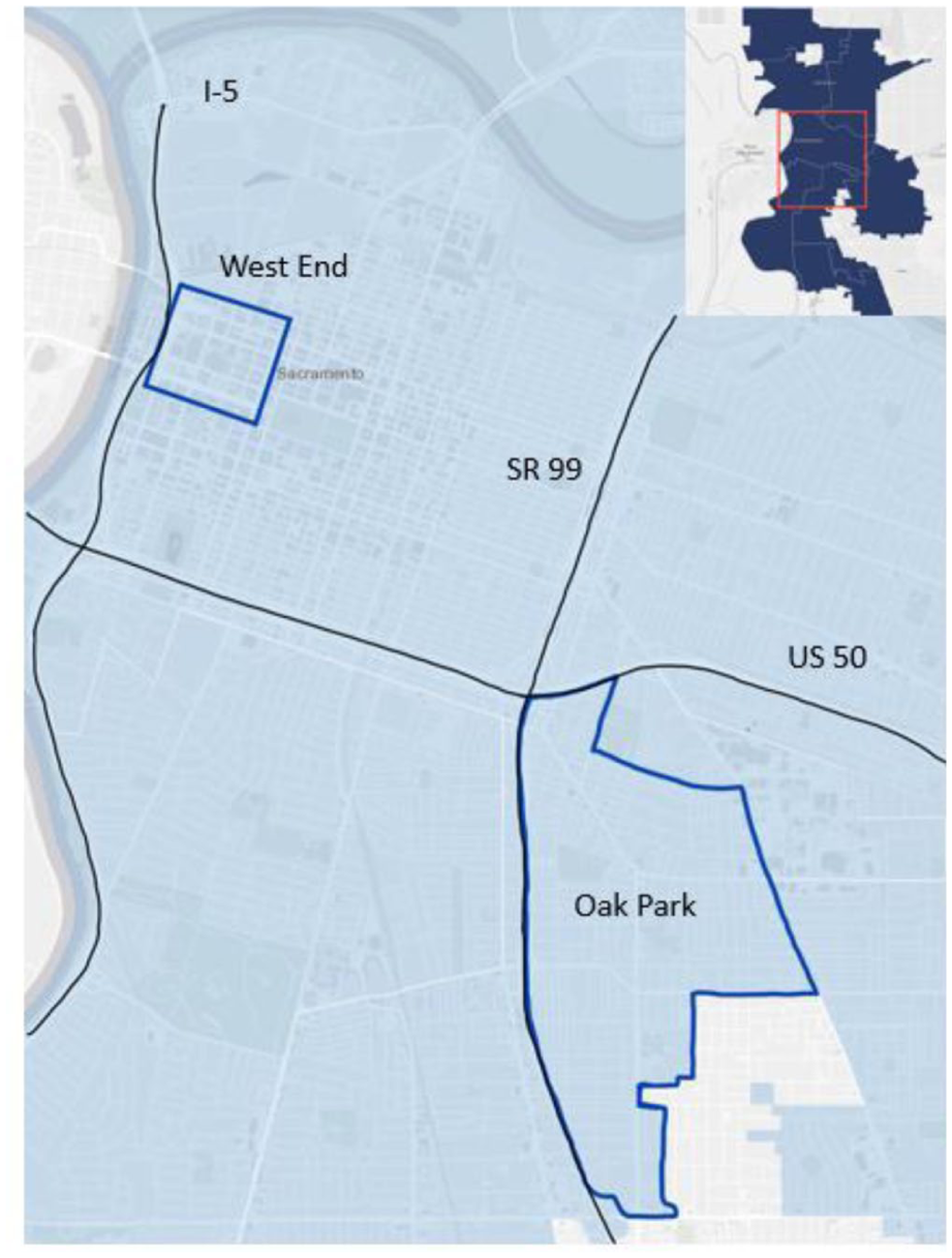
Sacramento’s West End and Oak Park. 22
Beginning in the 1940s, the demographic landscape of the neighborhood changed significantly. The internment of Japanese Americans during World War II devastated the community as residents were forced to sell their properties and businesses at prices far below their market value. This led to an influx of Black and Latino/a workers who took over the homes and businesses previously owned by the Japanese community in the West End. 23 Following the war, the new residents as well as returning Japanese families were again displaced, this time by federally backed redevelopment through the Capitol Mall Redevelopment Project. 24
The Federal Housing Association’s (FHA) practice of denying mortgage insurance to older buildings in low-income neighborhoods and areas of color contributed to the characterization of the area as “blighted” under the Housing Act of 1949. 25 In 1957, 62 blocks of the West End were designated as the “Redevelopment Area No. 1.” The Sacramento Redevelopment Agency demolished many buildings to make way for the Capitol Mall project and upcoming freeway construction.
The West End neighborhood was an ethnically diverse area at the time of the urban renewal effort. Approximately 70 percent of Sacramento’s non-white population resided in the West End, where people of color constituted nearly two-thirds of all residents. 26 Between 1950 and 1970, population in downtown area declined by 31,000 due to the Capitol Mall redevelopment project followed by the construction of SR-99 and US-50 as well as zoning changes. 27 In one census tract that included most of Japantown, the population dropped from 4,467 residents in 1950 to 377 residents in 1970. 28 The number of single men living in the West End declined from 5,500 in 1957 to just 1,400 in 1963. 29
From the West End, many uprooted residents settled in the Oak Park neighborhood just southeast of downtown (Figure 1). Racially restrictive covenants and redlining limited their housing options elsewhere. 30 While some residents relocated to suburban areas farther from the Capitol, 31 many found Oak Park to be one of the few neighborhoods accessible to them. As Black families moved in, white families and businesses exited, a pattern consistent with white flight trends observed nationwide. 32 By the early 1970s, Oak Park had itself been designated a redevelopment project area, demonstrating the iterative and racialized nature of urban renewal in Sacramento. 33
The Freeway Planning Process and Public Resistance
In 1946, state officials along with city and county leaders proposed the building of a freeway system in the Sacramento region. 34 In 1948, a comprehensive traffic study was conducted to understand the transportation needs of the region after which the State Division of Highways and the Federal Public Roads Administration created a general plan for the construction of freeways through the city. 35 In early 1949, routes for a north-south freeway (what would become the Elvas Freeway/SR-99), and an east-west freeway (what would become the El Dorado Freeway/US-50) were proposed and presented to representatives of the city, the county, and the Sacramento Chamber of Commerce. 36 These two freeways were at the time a part of the plans for Interstate 80 (I-80), with Interstate 5 (I-5) planned along the western edge of the city along the river. 37 Residents and businesses opposed the construction of the north-south freeway through the center of the city and raised concerns about the potential adverse impact of the east-west freeway on neighborhoods. The placement of I-5 was also debated and contested because of its impact on Sacramento’s historic core. Despite the opposition, the California Highway Commission adopted the freeway plan encompassing all three freeways.
US Route 50: El Dorado Freeway
Plans for the construction of the El Dorado Freeway were discussed in the early 1950s. 38 In 1958, the State Division of Highways, based on advice from DeLeuw, Cather & Co., proposed three route options between 8th and 30th Streets. Known as Alternatives A, B, and C these routes cut through densely populated residential areas. As shown in Figure 2, Alternative A would be a straight route between T and U Streets, Alternative B would have a small jog north to between S and T streets, dropping back at 23rd Street, and Alternative C would have a larger jog north to between P and Q streets, gradually turning south at about 26th Street. These proposed routes through the interchange with SR-99 were estimated to cover more than twenty blocks of area. 39
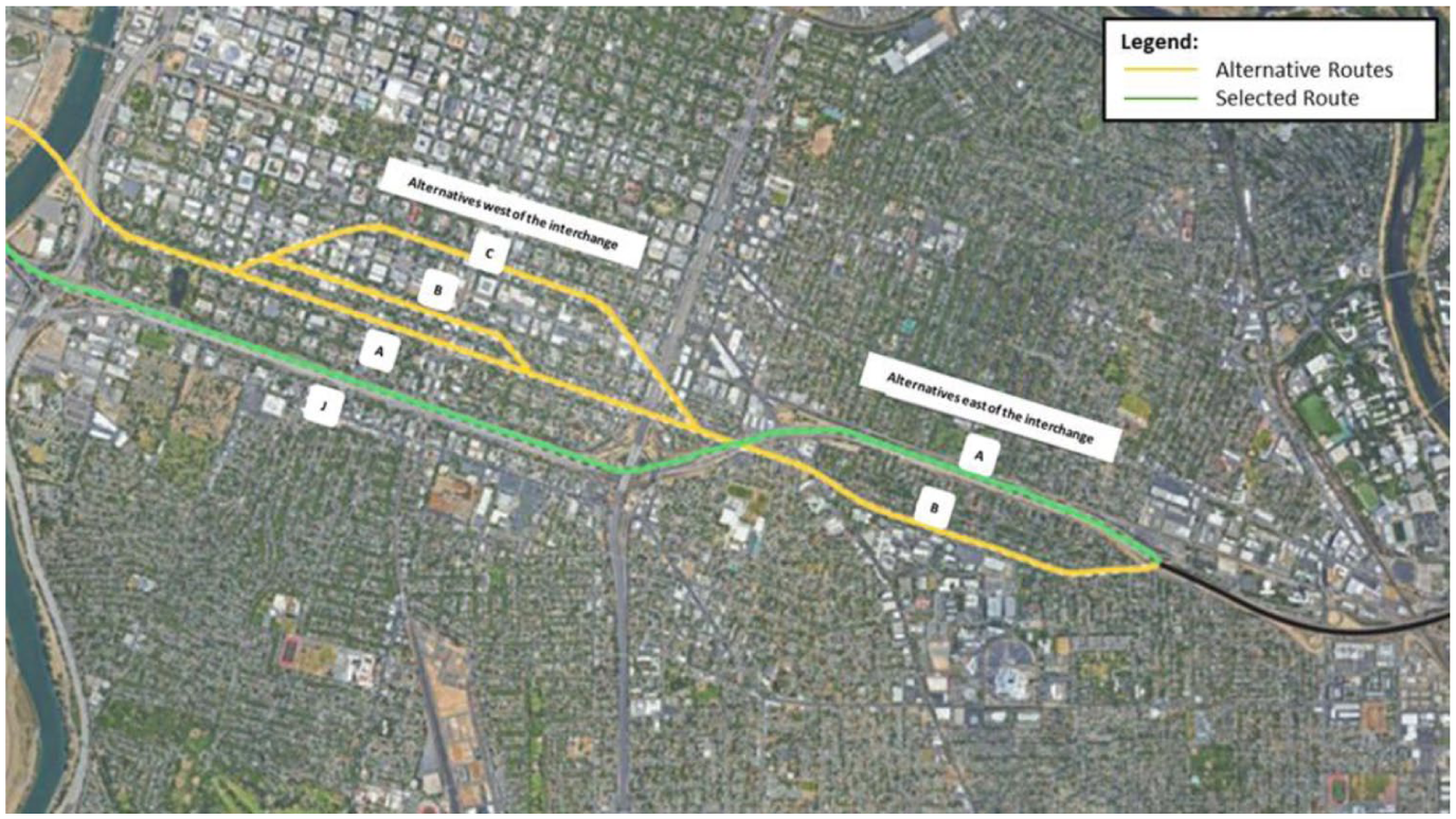
Alternate routes for US-50 East and West of the interchange with SR-99. 40
Public backlash to constructing the freeway through the heart of the city was immediate. Local newspapers, especially the Sacramento Bee, reported extensively on community concerns. Otto Pearson, a resident of U Street who later became the face of the community in organizing protests against the freeway routings warned the City Council that more than 1,200 homes and businesses would be lost and property values would plummet. 41 Over 500 residents also held a community meeting in advance of the official hearing. Residents expressed concerns regarding the displacement of elderly residents who would incur debt in locating elsewhere. On January 14, 1959, more than 800 people attended a public hearing and many signed petitions to revise the proposed routings to avoid detrimental effects to residents who would be sandwiched between the freeway and an industrial zone. 42
Following public outcry, the City Council hired consultants from Leo A. Daly and Associates to undertake another freeway feasibility study based on which they introduced Alternatives D and J (Figure 2). 43 At a second public hearing in February 21, 1961, 650 attendees reviewed these new options. Despite continued opposition, the California Highway Commission selected Alternative J, a southern route between W and X Streets. Even this route faced dissent from both potentially displaced residents and downtown businesses that feared losing customer access. 44 One resident writing to the Bee voiced concern about the compensation from the state being insufficient to buy a new house at prevailing market rates and expressed emotional attachment to their house, slated to be demolished to make way for the freeway. 45
The second leg of US-50, running eastward from SR-99 through Oak Park to Mayhew Road, was planned in 1962. The plans offered two routes for this segment, one along R Street and another between T and U Streets (Figure 2). The state adopted the northern R Street route. In contrast to the first leg, this segment encountered less vocal resistance. 46 The construction of this segment began in 1970, and it opened in late 1971, significantly impacting Oak Park by severing its connection to rest of the city.
State Route 99: Elvas Freeway
The first section of the Elvas Freeway was built from A Street to the northern boundary of the city in 1955, and the central section from A Street to P Street was completed in 1967. But the southern leg from the intersection with US-50 starting at U Street and 29th and 30th Streets to Stockton Boulevard, popularly known as the South Sacramento Freeway and now SR-99, proved more controversial. Forming the western boundary of Oak Park, this freeway created another barrier between the neighborhood and downtown.
The first public hearing for SR-99 was attended by 675 people on February 20, 1953, at the Governor Hall on the State Fairgrounds. Many attendees voiced their objection to routing the freeway through the center of the city. 47 One resident from I Street warned that the route would cut Sacramento into two parts and would cause damage that could never be repaired. Another feared that the freeway would draw too many trucks and through-traffic into populated areas. Several others expressed their sense of belonging and attachment to the homes they would have to leave, saying that no amount of money would be able to pay for the emotional loss caused by displacement. People also voiced concerns that freeways would become an obstacle for churchgoers, schoolchildren, and fire trucks. 48
In response, A. M. Nash, the district engineer defended the route as a necessary public good. 49 He commented, “It is, of course, obvious that many individuals whose property is affected in one way or another will be dissatisfied and critical of the selection of the route which has been made. This is only natural and human. But it is a physical impossibility to build a modern traffic facility in a metropolitan area without taking someone’s property.” 50 The chief right-of-way agent, Frank C. Balfour from the Division of Highways, assured the property-owners in the path of the freeway that scientific methods had been used to determine the fair market value of land taken and that every owner would receive their fair share of entitlements. He estimated that approximately 330 single-family dwellings and 26 multifamily dwellings, a church and 8 moderately sized commercial buildings would be affected by the proposed freeway. 51
As happened with US-50, 1 resident, Walter L. Cox from Sacramento Boulevard, speaking on behalf of 1,000 property-owners in the vicinity of the proposed freeway, asked the City Council to hold another public hearing. 52 However, the State Director of Public Works, Frank B. Durkee, denied the need for another hearing. 53 In response to a letter from the City Manager, Durkee stated, “It is not the policy of the commission to reopen formal public hearings on highway routings, and we do not believe any useful purpose would be served by doing so in this case.” 54 A citizen-led initiative to let voters decide on freeway alignments was also blocked when the City Council declined to include the measure on the 1953 ballot. 55 The construction of the segment of SR-99 surrounding Oak Park proceeded and was opened to traffic in 1961, further reinforcing the neighborhood’s isolation. 56
Interstate 5: The West End Freeway
Unlike the other two freeways, I-5 was routed through an already-cleared West End. With most residents of the neighborhood displaced by redevelopment by the late 1950s, opposition to the freeway came mostly from concerns over the impact of the freeway on historic parts of the city. Even so, in the end, I-5 faced a much longer period of public scrutiny and opposition than either US-50 or SR-99.
In the late 1960s, planners proposed the routing for this freeway between 2nd and 3rd Streets from I to N Streets. 57 This route threatened to demolish fifteen state-designated historic buildings, including the Big Four Building, a landmark of the transcontinental railroad. 58 The public hearing for I-5 coincided with the second public hearing for US-50 on February 20, 1961, in which alternative routes for I-5 were proposed. Opposition to the freeway increased after the public hearing: the State Highway Commission received more than 200 petitions containing more than 4,000 signatures opposing the 2nd and 3rd Street alignment from people across the State. 59 The preservation of the neighborhood became a matter of community, civic, and historic values. Historical organizations including the National Trust for Historic Preservation in Washington D.C. and the California Historical Society joined in opposition. 60
Despite the opposition, on May 24, 1961, the California Highway Commission adopted the route following 2nd and 3rd Streets for the freeway, though the state could not yet move forward with construction plans. U.S. Secretary of Interior Stewart Udall intervened, halting federal funds until preservation measures were agreed upon. An eventual compromise ensured that the Big Four Building would be preserved. The Highway Commission also agreed to work with the State Division of Beaches and Parks and the National Park Service to clearly lay out a plan for preserving and recreating historical sites, buildings, and areas in Sacramento. 61 Construction of I-5 began soon after and continued into the early 1970s.
Redlining and Route Selection
The planning and construction of urban freeways across the US intersected with long standing patterns of racial segregation. Beginning in the 1930s, the Home Owners’ Loan Corporation (HOLC), backed by policy of the Federal Housing Administration (FHA) policy, created maps that classified neighborhoods based on perceived lending risk. These classifications were clearly influenced by the neighborhood’s racial composition, a practice widely known as “redlining.” Neighborhoods designated as least desirable were color-coded in red and marked “hazardous” (Category D) while those deemed “declining” (Category C) were coded yellow. These designations limited access to mortgage credit for families in redlined areas, curtailing homeownership opportunities and contributing to a racial wealth gap that persists to this day. 62
In Sacramento the freeway planning process unfolded within this environment of discrimination. The alternative routes proposed by the Division of Highways for US-50 on both sides of the interchange with US-99 passed through the ”Category C” neighborhoods, areas largely populated by white working-class families and immigrant communities. Routing the freeway through these areas (Figure 3) served the joint purpose of creating freeway access to the redeveloping downtown and razing the remaining areas that fell just outside of the Capitol Mall Redevelopment Project boundaries.
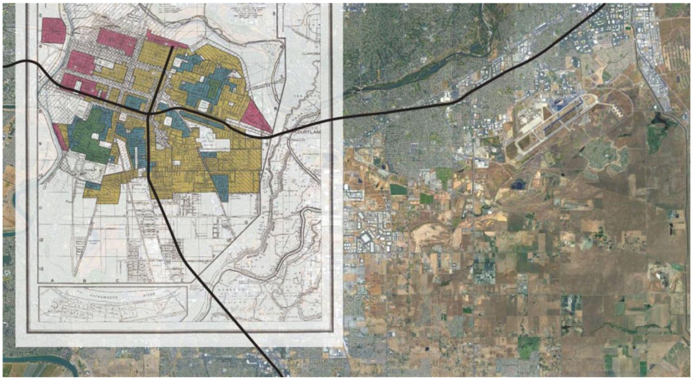
SR-99 and US-50 on HOLC map of Sacramento. 63
This approach to redevelopment reflected an emerging pattern in which state and local authorities targeted neighborhoods with limited political power, where land was cheaper and resistance from residents was weaker. These early decisions would initiate a cycle of displacements for Sacramento’s minority communities. Many residents displaced from Sacramento’s West End, a dense, racially diverse district cleared for the Capitol Mall, soon found themselves in the path of new freeways, or relocated to neighborhoods such as Oak Park, which would later experience freeway encroachment.
Displacement and the Impact on Community
After the Capitol Mall Redevelopment Project displaced thousands of residents from the West End in the 1950s, Oak Park became one of the few neighborhoods where Black families could relocate, given racially restrictive covenants and widespread redlining elsewhere in the city. 64
Oak Park, originally a working-class “streetcar suburb” annexed to the city in 1911, had been over 93 percent white in 1950 65 and classified as “Category C” on the HOLC maps. As Black residents moved in, many white families relocated to the burgeoning suburbs, a pattern consistent with nationwide white flight. 66 The construction of US-50 and SR-99 further reinforced these racial and economic divides as SR-99 created a barrier between Oak Park and the whiter, wealthier Land Park neighborhood, 67 while US-50 severed its northern edge from the affluent “Fabulous Forties” neighborhood. 68 By the early 1960s, the neighborhood was undergoing rapid racial transition.
The routing of US-50 along Oak Park’s northern edge and SR-99 along its western boundary physically severed the neighborhood from downtown Sacramento and nearby employment centers. A temporary ramp built during the construction of the US-50 freeway offered limited access to the residents, but it was permanently removed in 1972. 69 Interviews in 2022 with residents who grew up in the area around what is now the junction of SR-99 and US-50, described the implications for the neighborhood. One community member recalled, “That highway was built to cut off community members from other areas of the city, and there’s no doubt about that this is a redlined neighborhood.” 70
The removal of the ramp also left Oak Park residents bearing the brunt of the noise and emissions generated by traffic on these freeways. As recalled by another resident, “there was a heavy focus on the prevailing winds in the area going from West to East. This creates a huge air quality issue for Oak Park, as it sits to the east of CA-99. Curtis Park and Land Park [both affluent, predominantly white neighborhoods] are spared from on-road pollutant as these sit to the West of CA-99.” 71
Beyond disconnecting the neighborhood from the city and imposing environmental burdens, the freeways altered Oak Park’s social fabric. As one of the residents described it, “I remember it was a mix of people that I grew up with . . . There were definitely a lot of minorities - I would say most were lower- to middle class. Nobody was rich there . . . There were a few friends of mine that lived in the area but they all had to move.” 72 They also mentioned that people had little to no political weight or resources and therefore accepted the fact that they needed to relocate. Residents were generally uninformed, and it was difficult for working-class families to organize and campaign to oppose the highway being built through their communities. Most just accepted the offer they received for their property and moved.
The damage extended to cultural and civic institutions. In the 1960s, freeway construction and associated clearance demolished the Sacramento Childrens’ Receiving Home, 73 and displaced several churches including the historically significant New Hope Baptist Church, which had an integrated but mainly Black congregation. The church moved for the second time since its formation in 1923. 74 Churches such as Bethel Temple and the Church of God in Christ were also forced to relocate. 75
Economic Decline of Oak Park
Oak Park’s physical isolation was accompanied by economic decline. Construction of SR-99 diverted traffic away from Stockton Boulevard, the neighborhood’s main commercial corridor, stripping local businesses of customers. As one interviewee noted, Stockton Boulevard had once been the main entryway into the city 76 and SR-99 redirected that flow. Vincent “Ted” Thompson, a Black business owner, told the Sacramento Bee that SR-99 not only cut Oak Park off from smooth access but also left the area without directional signs to the shopping center, thereby cutting off potential customers of what was once a bustling area. 77 The loss of business activity led to widespread closures and job losses in the community. 78
Further disinvestment followed, and the California State Fair Commission’s fairgrounds was also moved from Oak Park to northern Sacramento. This escalated the economic decline of the area, and the city soon designated Oak Park as “blighted” 79 and later as a redevelopment project area. 80 Urban renewal schemes demolished much of Oak Park’s historic business district along 35th Street. 81 The freeway and the associated infrastructure projects also reshaped the physical environment, replacing tree-lined streets with wide, barren boulevards and underpasses. 82 In one interview, a local activist also recalled that the freeway ended up not only preventing high school students from walking to school but led to the need for high school transfers in the case of students whose families were displaced by the freeway. 83
These changes coincided with an increase in crime followed by a racially discriminatory “law and order” policing strategies. 84 Reportedly, neither the Old State Fairgrounds redevelopment nor the construction of the SR-99/US-50 interchange employed the Oak Park residents, 85 denying them even short-term economic benefits from projects that devastated their community.
By 1980, Oak Park remained one of Sacramento’s lowest-income neighborhoods. During the 1970s when the city as a whole grew, recording an overall population increase of more than 8.5 percent, Oak Park’s population fell by more than 13 percent. Demographically, Oak Park had become one of the city’s most racially diverse areas in 1980, with a population that was 44 percent Black and 17 percent Latino/a compared to the city’s overall 70 percent white population. 86
Population Change and Housing Destruction
Over the decades, the City of Sacramento has undergone significant geographical as well as demographic changes. The city expanded through annexations after 1911, but the most significant growth occurred in the postwar decades. Between 1950 and 1960, the city’s population surged from 126,889 to 191,667 then slowed beginning in the 1970s (Table 1). While the city diversified between 1950 and 1980, analysis of Census data suggests that the population of color eventually concentrated in freeway-adjacent neighborhoods. The Black share of the population nearly doubled between 1950 and 1960, from 3.3 percent to 6.3 percent, and grew by another two thirds by 1970 before stabilizing from the 1980s onwards. The Latino/a population share grew at a similar rate during the 1950s until the 1970s but almost doubled from 14.2 percent in 1980 to 26.9 percent in 2010. The share of Asian population also increased from 8.7 percent in 1980 to 19.4 percent in 2010. By the turn of the twenty-First century, Sacramento had become a majority of person-of-color city.
Sacramento Racial/Ethnic Demographic Profile, 1950 to 2010.
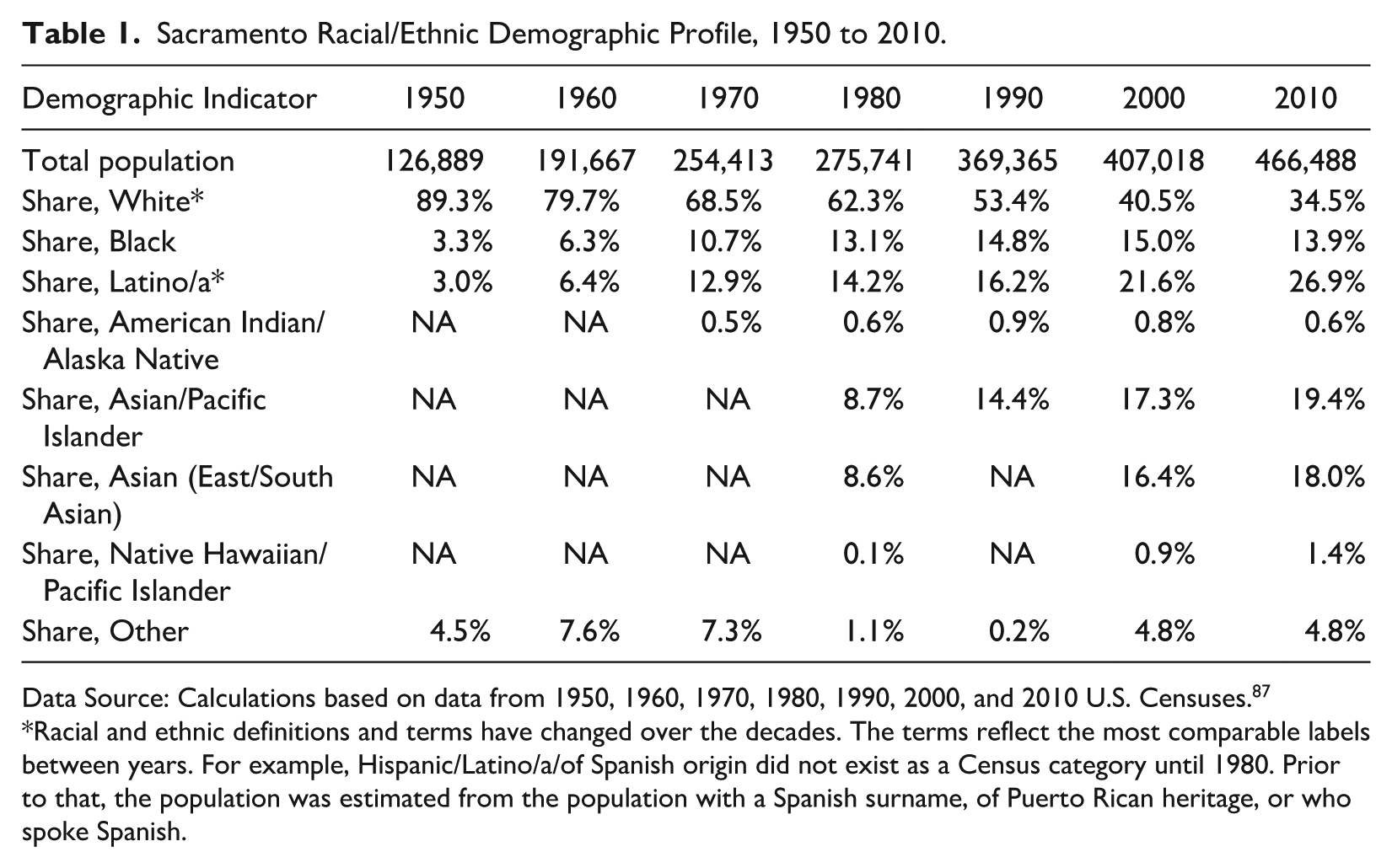
Data Source: Calculations based on data from 1950, 1960, 1970, 1980, 1990, 2000, and 2010 U.S. Censuses. 87
Racial and ethnic definitions and terms have changed over the decades. The terms reflect the most comparable labels between years. For example, Hispanic/Latino/a/of Spanish origin did not exist as a Census category until 1980. Prior to that, the population was estimated from the population with a Spanish surname, of Puerto Rican heritage, or who spoke Spanish.
Data from the U.S. Census shed further light on the impact of freeway construction in Sacramento on communities of color. The route ultimately selected for US-50 was constructed through the same census tracts where alternatives A and B were proposed (Tracts #18, #19, #20, and #21) with a small additional part of the alternate routes in Tract #8 (Figure 4). Alternative C did not pass through Tract #20 but did pass through Tracts #9 and #13 (Figure 4). The total population in these census tracts decreased substantially between 1950 and 1970 (Table 2). Consistent with the patterns of white flight across major urban areas during those years, the share of white population also decreased, from nearly four out of five residents to less than half. The Black and Latino/a populations grew and remained roughly consistent as a share of the population until 2000, after which there was a notable decline in the Black population. The Asian population grew from a maximum of about one in ten residents in 1950 (likely denoted by much of the “Other” category) to over two in ten by 1990, though it decreased by nearly half by 2010. Incomes and property values also declined in these census tracts relative to the rest of the city during and after the freeway construction.
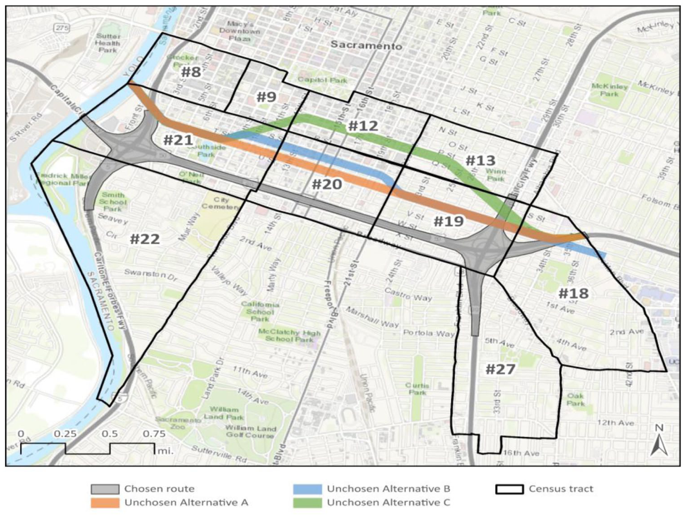
US-50 chosen route and impacted tracts. 88
Racial/Ethnic Demographic Profile of People in the Way of US-50 and Adjacent Tracts, 1950 to 2010.
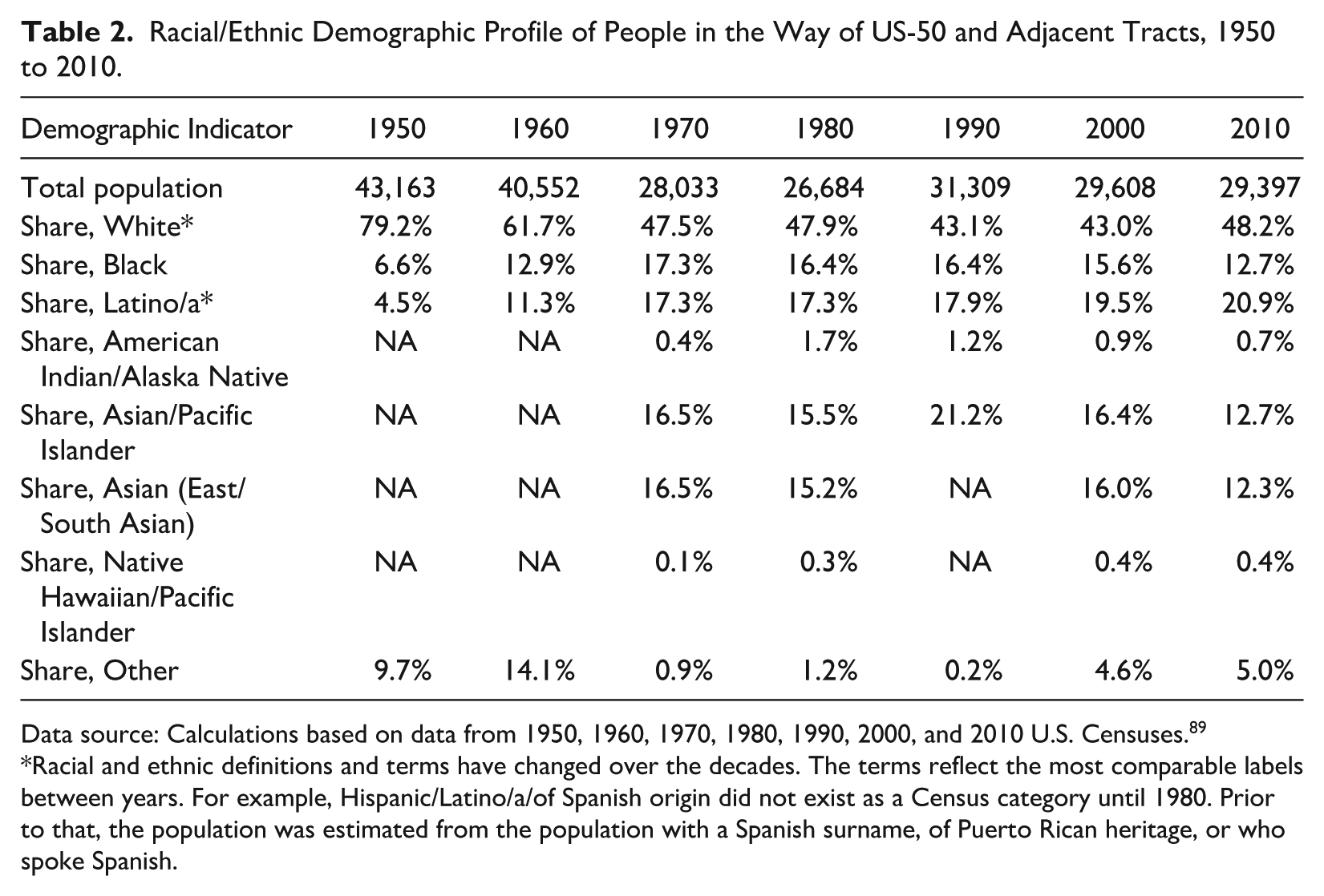
Data source: Calculations based on data from 1950, 1960, 1970, 1980, 1990, 2000, and 2010 U.S. Censuses. 89
Racial and ethnic definitions and terms have changed over the decades. The terms reflect the most comparable labels between years. For example, Hispanic/Latino/a/of Spanish origin did not exist as a Census category until 1980. Prior to that, the population was estimated from the population with a Spanish surname, of Puerto Rican heritage, or who spoke Spanish.
Construction of US-50 not only led to significant changes in the racial demographics of the census tracts adjacent to and in the way of US-50 and its interchanges with I-5 and SR-99 (Figure 4) but also destroyed 1,800 housing units, displacing roughly 4,500 people as indicated by the census data (Table 3). Almost half of these housing units were owned by their residents and one third of the displaced households were headed by people of color, a share higher than the overall city population (Table 1).
Estimates of Homes and Households Directly Impacted by US-50 Construction and Alternate Routes, Sacramento.
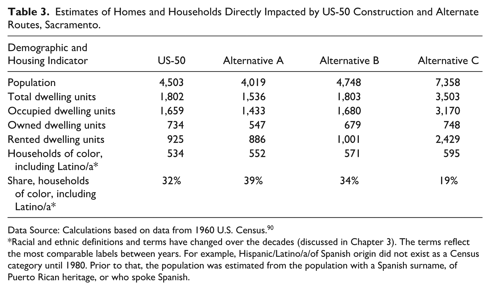
Data Source: Calculations based on data from 1960 U.S. Census. 90
Racial and ethnic definitions and terms have changed over the decades (discussed in Chapter 3). The terms reflect the most comparable labels between years. For example, Hispanic/Latino/a/of Spanish origin did not exist as a Census category until 1980. Prior to that, the population was estimated from the population with a Spanish surname, of Puerto Rican heritage, or who spoke Spanish.
Table 3 shows the estimated impact that alternative routes could have had on the housing units and households if selected for construction. Comparison with the alternate routes shows that the constructed route was neither the most destructive in terms of residents displaced nor the most disparate in terms of the racial composition of households displaced (Table 3). Constructing the freeway along Alternative A would have destroyed fewer homes than US-50 did, but a higher share of the households would have been non-white. Alternative B had similar characteristics to the actually constructed route: this alternative would have destroyed 77 additional occupied homes, displacing 300 additional residents, with about the same share in non-white households. Alternate C would have displaced the most individuals and destroyed the most homes of the four routes. However, a larger share of the population in the path of this route was white.
These findings further support the findings from qualitative analysis of Sacramento Bee articles and other historical sources that the placement of US-50 coupled with redevelopment, redlining, racial covenants, and white flight led to displacement of communities and economic decline of neighborhoods, even if the selected route was not overtly racist.
Conclusion
The Sacramento case illustrates how state-led freeway planning under the guise of modernization compounded racial inequities stemming from other policies. While the state did not overtly choose freeway routes to target communities of color, the interaction of highway construction with redlining, racially restrictive covenants, and urban renewal ensured that displacement fell disproportionately on Black, Latino/a, and Japanese American residents. These intersecting forces concentrated communities of color near freeway corridors, leaving them most vulnerable to environmental harms and economic marginalization.
Analysis of demographic and economic trends underscores that these effects were neither temporary nor incidental. Two decades after construction, neighborhoods bisected by US-50 exhibited slower income growth and persistently lower home values compared to other areas of Sacramento. Black and Latino/a residents were more likely to be concentrated in freeway-adjacent neighborhoods compared to other parts of the city following the displacement caused by freeway constructure.
Oak Park has continued to evolve in the decades following freeway construction. From a working-class white suburb to a predominantly Black neighborhood physically isolated by freeways, Oak Park exemplifies the spatial consequences of policies that prioritized suburban mobility at the expense of inner-city stability. This history complicates conventional narratives of freeway protest and accounts that locate injustice primarily in the alignment decision by showing how cumulative harm took shape through linked policies: urban renewal displaced residents, housing exclusion constrained relocation, and freeway construction reinforced isolation and decline, with these burdens falling disproportionately on communities of color.
The historical patterns of infrastructure-driven displacement continue to shape the neighborhood’s urban space even today. Over the past decade, Oak Park’s Black population declined by 24 percent even as the citywide Black population grew by 2 percent. 91 Projects such as the Aggie Square, a joint effort by UC Davis and the City of Sacramento to redevelop a 25-acre area adjacent to Oak Park, 92 and the in-progress widening of US-50 93 have reignited concerns about gentrification and renewed displacement in Oak Park. These new projects demonstrate that the racialized geography of infrastructure is not a relic of the past but an enduring feature of urban development. Recognizing this continuity is essential for designing transportation and redevelopment policies that repair rather than reproduce historic inequities.
This case study adds to the substantial literature on the impacts of freeway construction on disadvantaged communities in the U.S. in a number of ways. While much of the literature focuses on the impact of the Interstate Highway System, the Sacramento case is a reminder that highways of all designations can have significant negative impacts for communities. It illustrates the substantial impact of the interaction of freeway construction with other policies such as redlining, restrictive covenants, and urban renewal. Most importantly, it demonstrates that even when freeway routes are not chosen so as to target disadvantaged communities, these communities still disproportionately experience the negative effects of freeway construction.
Footnotes
Acknowledgements
The authors thank the Principal Investigators Anastasia Loukaitou-Sideris and Co-principal Investigator Paul M. Ong and UCLA and UC Davis research teams for conducting this research at the UCLA Institute of Transportation Studies, UC Davis Institute of Transportation Studies, and UCLA Center for Neighborhood Knowledge. Special mention to Katherine Turner for supporting the qualitative research efforts for the Sacramento case study.
Declaration of Conflicting Interests
The authors declared no potential conflicts of interest with respect to the research, authorship, and/or publication of this article.
Funding
The authors disclosed receipt of the following financial support for the research, authorship, and/or publication of this article: This paper is part of the research project titled, “The Implications of Freeway Siting in California: Four Case Studies on the Effects of Freeways on Neighborhoods of Color.” This study was conducted as part of the Pacific Southwest Region University Transportation Center research program. The authors would like to thank the U.S. Department of Transportation and California Department of Transportation for their support and for funding this project.