



Abstract
Examining what the author calls ‘small-screen panoramas’, a set of software-based digital panorama services that provide the production and navigation of panoramic photographs available for users’ experience on small-screen devices (laptops, mobile phones, tablet PCs), this article argues that the panoramas’ algorithmic view and movement signal an emerging visual regime that remediates the scale and mobility of their pre-digital predecessors. Digital compositing technique reinstates the sensory and epistemological conditions of the panoramic, ‘tourist’ gaze of modernity as it combines discrete pictures of a location into a 360-degree seamless visual field that proffers an immersive form of spectatorship. At the same time, however, the applications undermine the visual field and spectatorship of the traditional panorama as their technological features activate the embodied, material, and contingent aspects of mobile media spectatorship: the portability of laptops and mobile phones and the applications’ algorithmic streamlining of 2D photographs. These examples, the author claims, demonstrate that, despite the applications’ efforts to create seamless virtual 3D images, they lead to the paradoxical coexistence of the animated and the static, of the immersive and the miniaturized, and the embodied and the disembodied.
Keywords
Introduction
In one of her recent studies, Mary Ann Doane (2009) takes scale as a key ontological parameter to trace the history of technologies for representation of movement since the 19th century, identifying projection and the optical toy as two larger categories of their development. Projection, a technique applied to magic lantern shows, shadow plays and the standardized cinematic apparatus, means to produce and transport the larger-than-life illusion of motion for the sedentary viewer who attends it as an event. By transforming 3D physical, tangible space into 2D visual space, projection dematerializes both the illusory image and the viewer’s sensory relation to it. In the 19th century, according to Doane, this dematerialization was balanced by another tendency toward the materialization of the supports of the image – a demand for making our visual experience tangible and concrete: ‘The cinema, immaterial product of a beam of light, is haunted by the miniature, touchable, manipulable, opaque image’ (p. 152). The optical toys of the time met the demand by offering a small-scale image that viewers were able to look down at and play with in their domestic space. The image might not be as illusory and immersive as the large-scale projected image, but the image’s viewing interface and mode of perception – that is, holding its instrument in their hands – lend the image such senses as proximity, intimacy, and contingency. Taken together, projection and the optical toys demonstrate the extent to which an image’s scale entails the changing relationship between spectators, image space, and their viewing space. For Doane, these two archetypical visual interfaces were complementary with each other, although their historical relations include succession, simultaneity and precession: ‘It is not possible to claim that the optical toy and projection constitute separate successive historical stages or even that they have nothing to do with each other’ (p. 154).
Doane’s reconfiguration of the history of visual media through the prism of scale is particularly suggestive in thinking about the relation between digital visual images different in size and their corresponding modes of spectatorship. The projected image and the illusion of optical toys prefigured the two competing yet overlapping viewing interfaces that differ in scale and location: namely, the large-screen interfaces in the public sphere, on the one hand, and the small-screen interfaces installed in domestic and private spaces or made portable, on the other. More significantly, the development of electronic and digital media has increasingly prevented a total separation between the two types of interface and spectatorship, as demonstrated by broadcasting live events on public outdoor screens (that is, outside the TV box) or watching films on the portable screens of cell phones, laptops and tablet PCs in the form of video files, streaming videos and web-based graphic authoring platforms (such as Adobe Flash). This mutual convergence raises a crucial question as to how each of the two is transformed and dislocated: to put it differently, what would happen to the large-scale image and its aspects of spectatorship if they were adopted and transformed by the portable new media screens: namely, in Jay David Bolter and Richard Grusin’s (2000) words, how does the latter ‘remediate’ the representational conventions, techniques and spectatorial modes of old media?
This article seeks a partial answer to this question by examining an array of online-based and software-based service providers – particularly Microsoft Photosynth, 360cities.com and Google Street View embedded in Google Maps – that offer their users the opportunity to produce and navigate through 360-degree panoramic photographs. I call these photographs ‘small-screen panoramas’ in that they are distinct from the forms of traditional 19th-century panorama in different aspects, including parameters of technique and scale: first, these two types of panoramas share compositing as a key technique for ‘combining a number of image sequences, and possibly stills, into a single sequence’ (Manovich, 2001: 136–137). Unlike the 19th-century panoramas based on the manual blending of a series of painted pictures, however, the small-screen panoramas are derived from computational processes. The computer’s software algorithms or plug-ins automatically stitch together a set of 2D pictures taken by a variety of digital cameras, including the built-in camera installed in the portable digital devices; and second, in relation to scale, the 19th-century panoramas, as examined by film scholars (Friedberg, 1994; Griffiths, 2008; Miller, 1996) and media historians/archaeologists (Grau, 2003; Huhtamo, 2013; Oettermann, 1997), are seen to be not simply a mass medium of the time but also a key precursor of the ensuing large-scale media apparatuses (including the cinema). Indeed, the panoramas’ overwhelming viewing interfaces, such as the specially designed circular buildings (circular panoramas) and the immense spools on which their pictures scrolled past the audience (moving panoramas), were intended to produce an immersive, illusionist representation of reality. The small-screen panoramas are realized as their software applications and user interfaces attempt to adopt a few key aspects of visuality that the 19th-century panoramas fulfilled: the experience of limitless vision, the dimensional shift from 2D to 3D and the forms of mobility. At the same time, however, the services considerably destabilize both the ordering principle of the panorama and the viewers’ centrality it guarantees, due to their technological and experiential aspects: the applications’ automated, algorithmic streamlining of 2D photographs into a 3D circular photo, the services’ user interfaces that enable users to navigate in all directions and in or out of depth, and the mobility and portability of laptops and cell phones.
By investigating the lines of similarities and differences in terms of technique, viewpoints, viewing interfaces and the aspects of movement, I want to highlight the vision and perceptual experiences of small-screen panoramas as well as their users’ virtual travel to distant landscapes and locations in comparison to their predecessors. In so doing, I shall demonstrate how digital technology’s arrangements of images and viewing interfaces in the small-screen panoramas make the panoramic view and gaze of the digital photography distinct from those of the 19th-century panoramas while at the same time refueling them. By teasing out these double sides of remediation, I also want to stress how scale and movement stand out as two key parameters in explaining the small-screen panoramas’ spectatorship in two aspects: (i) its users’ perceptual experiences of moving in and navigating through its photos; and (ii) the social and cultural underpinnings of the experiences. All of these will lead me to argue that the small-screen panoramas, as products of arranging the all-seeing view and mobile gaze with the software and viewing devices of new media, are marked by the dynamic coexistence of 2D and 3D, the animated and the static, the immersive and the miniaturized, and the disembodied and the embodied in comparison to their predecessors. While the first two sections of the following focus on analyzing the technical – that is, algorithmic – layers of digital panoramic photography and examining the ways in which they add up to the complexities of its vision and mobility, I shall also discuss the sociocultural implications of the ambivalent visuality shaped by the small-screen panoramas. As I shall demonstrate in the latter two sections, the small-screen panorama, when it remediates the 19th-century panoramas, adds to the layers of coexistence another disjuncture of two different aspects with regard to panorama as a form of practices bound up with technology’s social and cultural uses. That is, while updating the traditional desire of panorama to conquer and objectivize space, on the one hand, the small-screen panorama coupled with mobile media also enables users to experience panoramic viewing more intimately and thereby acquire a dynamic, embodied relation to geographical and physical spaces on the other.
Exploring small-screen digital panoramic photography
Since the mid-2000s, a number of websites and software/mobile applications have enabled users to create 3D panoramic photographs based upon a series of 2D photographs or to publish them for multiple networked platforms, including digital maps (Google Maps, Google Earth, and Bing Maps) and social network services (Facebook, Flickr, Tumblr, etc.). Among them, Microsoft Photosynth (Photosynth.net, Microsoft Live Labs and the University of Washington, 2006) and 360cities (360cities.net/360cities s.r.o., 2010) are the two earliest and still-popular web-based services. Photosynth offers users its own downloadable processing application (Microsoft Image Composite Editor) to convert pictures captured from a single location with a single zoom level into an integrated immersive photo. It also provides users with menus for uploading their own panoramic photos and exploring those of other users. The website 360cities.net primarily concentrates on uploading and publishing user-created panoramic photographs for multiple platforms, but it also provides users with detailed instructions for creating them, as well as hyperlinks to several online providers or applications used to stitch pictures together, such as Panomonkey.com (online), Autostitch, Autopano Giga, PTgui, and Kolor Autopano Pro (software applications), just to name a few. Despite the differences in their range of user functions, the two panorama service providers commonly allow users to experience cylindrical and spherical views of their panoramic photographs: that is, by controlling their mouse on the desktop or laptop, the users are able to navigate the entire field of view of a place depicted in a photo; in other words, they can explore what was standing around the photographer who took it in all directions (in the case of the cylindrical panorama), or they can look up and down along the vertical axis when selecting the 360-degree field of view (in the case of the spherical panorama). The growing popularity of these service providers and the software applications for image stitching was almost contemporaneous with Google’s release of Street View in 2009. Once users drag the pegman icon onto a location on Google Maps and Google Earth, they can display 3D panoramic views of stitched images taken from numerous cities and rural areas worldwide. Unlike the cases of Photosynth and 360cities.net, the production of so many street photos embedded in Street View was made not by amateur photographers but by professional teams equipped with nine directional cameras for 360-degree views mounted on a vehicle (Cummins, 2008). Nevertheless, Google’s reworking of the taken photos into panoramic pictures is as much grounded in applying image processing algorithms to lessen seams between them and create smooth transitions as in the Photosynth application and other available image stitching tools. 1
The rapid development of mobile media and location-based/mapping service providers during the last few years has propelled digital panoramic photographs’ popularity, encouraging them to be produced and experienced by the hands of users on the move. Both Photosynth and 360cities expanded the scope of their services by releasing their own mobile applications. The key mechanism of these applications (apps) enables users to create their own panoramic photographs with a mobile phone equipped with an internal high-resolution camera. When users open the apps, they are able to activate the built-in camera and take pictures of the place where they stand, in all directions surrounding them, just by tapping the phone screen. Then the apps automatically stitch the pictures together to complete a synthesized panoramic photo, which the user is capable of sharing via social network applications and online maps (see Figure 1).
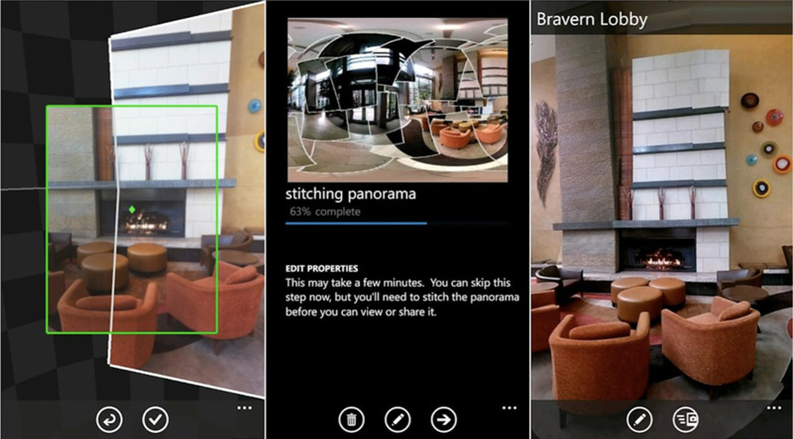
Screenshot of Photosynth app’s stitching and geotagging processes. Photosynth is available online at: Photosynth.net
The software applications and online-based or mobile-based digital panorama service providers are able to automatically detect a series of uploaded pictures that were taken from all directions around a photographer. The applications then identify each picture’s angle, distance, focus, exposure, and the point at which the picture was taken, comparing the features of one photograph with those of the others. These calibrated and adjusted images are finally blended together and integrated into a virtual 3D model attuned to the viewer’s multiple modes of interactive navigation – panning, zooming in and out and flying through – via a completed panoramic photograph. The 3D model, then, is not totally arbitrary once it is grounded in an array of geometric and visual attributes extracted from the pictures processed by the software algorithms. In this sense, it could be said that the 3D small-screen panoramic photograph pertains not simply to the domain of digital photography but also to that of computer graphics, because its production process involves image-based modelling and rendering (IBMR), namely, a set of methods to make use of multiple 2D images of a scene to generate a 3D model, which is in turn fed into algorithms for analyzing groups of 2D pictures and producing composites of them (Oliveira, 2002). One variant of IBMR methods, which is exemplified by Photosynth, can generate a point cloud of a 2D picture, which is a set of vertices defined by the 3D coordinate system. The point cloud is a system for configuring and rendering models of a 3D object or place by scanning and measuring its surface. This method had been developed in the domains of computer graphics, such as CADD (computer-aided design and drawing) in architecture and industrial design (Snavely et al., 2007). In Photosynth, the point clouds indicate a set of 3D vertices that constitute a mathematical model of the whole field of view: the circular representation of the space produced by the photographs stitched together. Based on the method for producing point clouds, the panoramic photograph produced by Photosynth follows the three-step process governed by its software algorithms: first, Photosynth encodes or translates the surface features of the 2D photographs into corresponding mathematical coordinates, namely, point clouds; second, it builds a 3D model that consists of the point clouds; and finally, it uses digital compositing, with which it adjusts and assembles the photographs into the model of the circular or spherical view of the space. All these processes validate that both photographic and graphic elements coexist in the panoramic photos generated with Photosynth – as in those produced by other imaging applications.
Despite the popularity of digital panoramas, there has been a notable paucity of studies on their technical and representational specificities based on the automatic recombination of 2D photos into a 3D picture, much less the ways in which their underlying algorithmic processes redefine relations between the viewing subject and the world viewed. William Uricchio’s (2011: 25) study of Photosynth’s synthesis of digital panoramic photos is remarkable in this context, as he considers it as emblematic of the ‘algorithmic turn’. By this term, Uricchio means the emergence of a new computational visual regime that ‘challenges western representational norms dominant in the modern era’, which rely on the viewer’s perceptual abilities to correlate the image and the world represented. The algorithmic process of Photosynth’s software application, Uricchio argues, leads to a programmed visuality marked by dynamic and multiple viewing positions and perspectives ‘through its subverting of any particular point of view’ and thereby ‘disrupting the modern configuration of the subject–object relation’ (pp. 29–30). The multiplication of viewpoints, as well as a range of navigational movements to and within the small-screen panorama, is seen to distinguish Photosynth’s application from the modern perspective system confirming the viewer’s stable relation to the represented object. For both aspects of Photosynth are predicated upon the application’s program layer that lies outside the control of the user.
While acknowledging Uricchio’s detailed investigation of Photosynth’s processing mechanism, as well as his compelling terminology of the ‘algorithmic turn’, I would also highlight a key limitation of his study. Uricchio draws his concept of the ‘algorithmic turn’ as the programmed visuality (distinct from the modern one) from the comparison between the visuality of modern painting and that of digital 3D panoramic photography. In this course, he does not reach the pre-digital panoramas after which the small-screen panoramic photos are modeled. Initially, this obviates that the visuality of the 19th-century panoramas is considerably distinct from that of the Renaissance perspective on which the modern representational painting was founded. More significantly, what is also overlooked here is that the 19th-century panoramas prefigured the two key aspects of algorithmic visuality identified by Uricchio: the composite nature of multiple viewpoints and the range of the viewer’s movements, both of which have to do with the coexistence of two-dimensionality and three-dimensionality. The latter aspect, namely, the sense of movements that guarantees the viewer’s virtual travel to distant places and re-enacted actual events, was what made the 19th-century panoramas a media formation complicating a sharp distinction between stasis and motion in the lines of the development of visual technologies. As Walter Benjamin (1992[1938]: 242) once noted, ‘before the movie had begun to create its public, pictures that were no longer immobile captivated an assembled audience in the so-called Kaiserpanorama.’ Benjamin’s insight into the affinity between cinema and the 19th-century panoramas with respect to the viewer’s virtual mobility has been acknowledged by Anne Friedberg’s (1994) media-archaeological concept of the ‘mobilized virtual gaze’ and Giuliana Bruno’s (2002) study of the ways in which the cinematic gaze has adopted and enhanced that of the flâneur in the architectural and urban spaces. The relevance of these two studies to the digital panoramas experienced on the small-screen interfaces lies in the ways in which the digital panoramas adopt not simply the subject matters of 19th-century panoramas and panoramic films in early cinema but also their organization of the viewer’s gaze into multiple perspectives, distances, and times. The digital panoramic photographs inherit from their pre-digital predecessors a range of techniques for creating visual illusionism in terms of both the appearance of represented space and the range of movements. Their repertoire of the viewers’ manipulations – zooming in and out, panning and tilting up and down – is intended to enable viewers to feel as though they are moving around their central viewing area. The mobile camera responsible for creating this range of manipulations in the small-screen panorama, as Lev Manovich’s (2001: 78–93) seminal The Language of New Media demonstrates, points to a ‘cultural interface’, a form of user navigation and 3D visualization that the computer adopts from the technical traditions of both the 19th-century panorama and the cinema.
Within these media-historical and trans-medial views, Ingrid Hölzl’s (2010: 100) argument on the necessity of viewing a variety of digitally mobilized photographic images in relation to their predecessors (including the 19th-century panoramas and the cinema) bears a considerable weight in the context of explaining the ontological complexities of small-screen panoramas – their dimensional complexity and their fusion of immobility and mobility: The convergence of moving and unmoving images in digital media (on the level of post-production as well as on the level of dissemination) is already laid out in the media history of photographic and filmic images and their hybrid forms.
What is at stake, then, is the need to make more detailed comparisons between the small-screen panoramas and their precursors. In this regard, I shall demonstrate that scale emerges as a key parameter in terms of how the former remediate the dimensional and kinaesthetic elements of the latter while simultaneously introducing new aspects of dimension and mobility grounded in the specificities of the computer-based imaging and viewing.
Heterogeneous scales in digital small-screen panoramas
Compared to the traditional panorama of the 19th century, the virtual small-screen panorama necessarily hovers between different gazes, spatial configurations and generation processes – divided into detecting, modeling and compositing. For this reason, it involves the dynamic coexistence of two-dimensionality and three-dimensionality, and of the photographic and the computer-graphic. The illusion of the immersive image space in the traditional panorama was grounded in its production of multidirectional viewpoints that were reassembled into its spectators’ embodied sense of spatial presence and continuity. As examined by Alison Griffiths (2008) and Oliver Grau (2003), the spectators’ multiperspectival gaze in the traditional panorama exceeds the linear perspective system that positions the viewers in detached, disembodied ways by abstracting their relationship with the rendered space and the objects positioned in it.
2
To be sure, the traditional panorama’s 3D photorealistic view and its multiperspectivalism have been adapted to real-time 3D computer graphics since the digital age, ranging from various VR applications used for scientific, industrial and entertainment purposes to the interactive digital cartographic environments enabled by the GIS (geographic information system) such as Earthviewer (which would later become Google Earth). In one of his interviews, Avi Bar-Zeev, who participated in the development of Disney’s Aladdin’s Magic Carpet VR Ride and later became co-founder of Keyhole as the maker of Earthviewer, mentioned that the panoramic view and its viewing mode formed ‘an intermediate stage’ in his series of virtual 3D models in which 2D photographic images of the geographic areas were sampled and synthesized for the viewers’ all-encompassing and free-roaming gaze: The ideal is to have an equally photorealistic view of the world, but from any chosen point of view, not just the places they sampled, and in a much more fluid form. That means I could move freely and smoothly in any direction for as long as I want. (quoted in Crampton, 2008: 88)
At the same time, the virtual panorama underscores the tension between the three-dimensional illusion and the composite nature of the two-dimensional. It arises when the panorama’s software algorithms attempt to suture multiple pictures into a seamless, photorealistic unity of 3D space. Uricchio (2011: 30) sees Photosynth’s panoramic photographs as the ‘fabric of radical disjunctures in viewing position and the fundamentally unstable nature of the composite’. The software algorithms of Photosynth, 360cities and other small-screen panorama applications or service providers indeed do not immediately produce a single person’s physical perspective. Instead, they determine the viewer’s multiple, navigational perspectives according to a host of disparate data (size, scale, focus, angle, depth, exposure, position) that they automatically extract from each of the photographs before constituting a single panoramic photograph. Thus the resulting multiple perspectives are derived from the software’s disembodied gaze with which its pre-determined 3D space allows the viewer to identify. In the case of Photosynth, this determination of perspectives hinges on whether one photograph fits into other point clouds automatically calculated based on the angles and positions of the other processed photos. This calculation makes it impossible to synthesize some photographs that are not smoothly overlaid with the established points of cloud. Although the software is able to synthesize the multiple photos into a single panoramic one, the relative differences in angles, sizes, distances and lighting are not totally eliminated from their surfaces. That is, the software’s algorithms do not totally conceal the 2D photos’ discrepancies of properties (for instance, the time at which each of the photos was taken was not the same), although their point clouds add up to the 3D model that they recognize. In Photosynth, the software’s failure to remove these discrepancies often results in two notable traces marking its panoramic photos. First, some resulting photos reveal their miniaturized and repositioned aspects and are thus seen as the total sum of numerous fragmented photographs, which presents frozen traces of motion (as if they have been taken in different time periods); and second, if the photographers do not take precise control of their distance and position with regard to capturing a certain number of pictures in all directions, their output is marked by the discrepancies of their angle, scale, and position, which leaves black infills on its background (see Figure 2). Then it is the visibility of those traces that makes the Photosynth panoramas often oscillate between two-dimensionality and three-dimensionality.
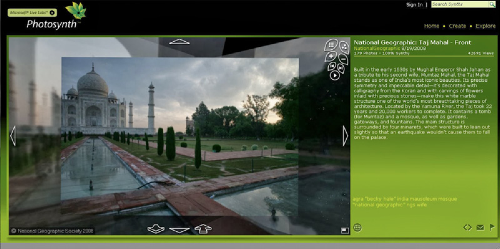
Screenshot of the disjuncture of 2D and 3D in Photosynth’s algorithmic stitching process. Photosynth is available online at: Photosynth.net
Certainly, the software’s revelation of the assembled aspects of its digital panoramic photos due to its technical flaws prevents users from getting the seamless perspective afforded by the circular panorama of the 19th century. These flaws, I would argue, remind us of the importance of two factors in determining a specificity of the spectatorship of small-screen panoramas in comparison to its precedents (which they attempt to remediate): the scales of the original pictures and that of the interface. Griffiths (2008: 40) notes that although the 19th-century circular panorama uses the technique of compositing for combining different pictures to establish multiperspectival views, it still achieves an immersive mode of spectatorship through ‘its scale’ and its 360-degree viewing interface that creates ‘the sense of “being in a different time and space”’. Griffiths’ observation echoes Erkki Huhtamo’s (2002: 203) view on Robert Barker’s first circular panoramic painting in 1793, as he writes: Barker’s patent concerned a new method of creating and displaying very large paintings. An enormous canvas, depicting a single situation or location, was stretched horizontally along the entire inner wall of a specially constructed cylindrical building so that its ends merged seamlessly. By skilfully hiding the upper and lower margins (often by props) and controlling the (natural) lighting from the outside the painting was turned into an illusionary environment. The audience, observing the view from a platform in the centre of the building, was meant to feel, as Barker put it, ‘as if really on the very spot’. (emphases added)
Also, these flaws help us to distinguish the automatically composed panoramic photographs from other digitally produced large-scale panoramas based on VR (Virtual Reality) applications. Since the 1980s, numerous artists, including Michael Naimark, Jeffrey Shaw and Maurice Benayoun, to name just a few, have endeavored to experiment with an array of 3D kinetic and architectonic viewing interfaces inspired by the immersive aspects of the 19th-century panoramas to different degrees (Kenderine, 2007). Accordingly, seminal works such as The Legible City (Shaw, 1991), Be Now Here (Naimark, 1995–2002) and World Skin (Benayoun, 1998), explored the viewer’s interactive sensory and cognitive immersion into the virtual three-dimensionality of computer graphic space in conjunction with the digitally constructed technological apparatus. 3 The common aim of the works’ interfaces is to create the enclosing viewing space detached from the viewers’ external reality and equipped with interactive input terminals in order to allow their viewers to move in physical space so that they can experience movement in virtual space. This screen-less space is modeled after the VR scheme, in which the viewers’ external reality should be excluded from the virtually rendered image space in order to create the viewers’ sense of ‘being in there’. This scheme is not maintained in the case of small-screen panoramas due to their relative small scale of viewing devices (monitors, laptops, and mobile phones), and the devices’ dependence upon the framed screen that forms a boundary between the viewing situation and the image space.
This comparison between the small-screen panoramas and the large-scale ones, too, informs us that the algorithmic visibility marked by the automatic composition of heterogeneous views and by the coexistence of two-dimensionality and three-dimensionality has much to do with the matter of scale in relation to the sense of movement, in terms of digital panoramas’ remediation of their precursors. In my view, what Uricchio overlooks in his study of Photosynth is the relationship between the compositing algorithms and the modes of traveling and navigation afforded by the interactive viewing interfaces. Studies on computer graphics, particularly those about digitizing and visualizing the 3D world from 2D photos, have observed that the photos’ scale – along with their position and orientation – is a key variant for successful compositing and processing (Kroefl et al., 2010; Snavely et al., 2010). In the case of Photosynth, one of the most frequent problems involves matching photos different in size and orientation and taken from various distances – for instance, matching a larger view of an architectural construct with a close-up of its particular details for positioning them side by side into a desired 3D model (see Figure 3). As I mentioned earlier, this matching process often results either in a ‘synthesized’ photo whose view is more or less different from a reliable panoramic one, or, if reliable, a panoramic photo that presents a circular scene yet reveals the heterogeneity of its viewpoints – namely, the impression that the larger-scale shot and the smaller-scale shot of the same location or building exist a bit incongruously. Then it seems that repeating calculations and alignments for acquiring a better result is not the only solution. In my view, Photosynth endeavors to solve this scale problem by developing the capabilities of its algorithmic interface to create as smooth transitions and movements as possible: for users to smoothly zoom in and out of the composite photos, to see them from any angle and to smoothly change the angle between nearby photos – photos originally different in scale (also in distance, position, orientation, and resolution). 4 But this solution suggests another specificity of the small-screen panorama and its organization of the users’ virtual travel: the desire of its algorithms to provide users with different scalar views serves as the algorithms’ driving force to assimilate heterogeneous 2D photos into the virtual 3D space where the image’s scale and the viewing position are inherently flexible and subject to – as in the case of compositing itself – their automatic calculations. This is certainly another aspect of what Uricchio has called the ‘algorithmic turn’. Then the different scalar views contribute to transforming the sense of movement in the 19th-century panoramas in two ways: first, expanding the scales of the scenes observed in the circular 3D space as well as the users’ perceptual approaches to the scenes (with their assembled photos dramatically enlarged or shrunken), and second, strengthening the disembodied aspect of the scalar views and movements that is attributed to the algorithms’ automated processes. These two transformations lead to a notable paradox of the spectatorship in the small-screen panorama, which is distinct from that of its large-scale counterparts marked by the viewers’ physical movement: a disjuncture of the viewers’ immobile and frontal positioning in front of the screen framing the circular views from a distant place, and their virtualized gaze whose mobility is much more augmented.
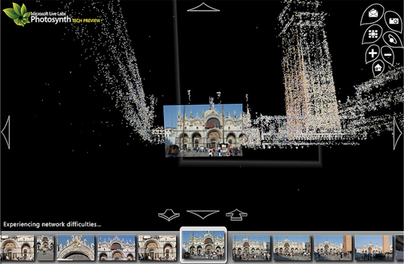
Screenshot of Photosynth’s matching of 2D pictures in different scales with point clouds. Photosynth is available online at: Photosynth.net
Google Earth, panoramic photography and the ambivalent conquest of space
The dynamic coexistence of the viewers’ immobility and the simulated travel to distant geographic spaces in the small-screen panorama culminates in virtual map services such as Google Maps, Bing Maps and Google Earth. For their software platforms provide viewers with 2D and 3D photographic representations of a desired location coupled with multiple perspectives and navigational vectors. As Francesco Lapenta (2011: 18) notes, the virtual maps signal a paradigm shift in geographical mapping from a ‘homogeneous physical organizing principle’ grounded in the direct link between a real location (and its objects) and an observer to ‘a heterogeneous and hybrid organizing principle’. This shift entails the transformation of our perceptual relation to the location, as well as of the spatial relation between the images that constitute the map. Similar to the small-screen panoramas, the virtual maps are also predicated upon digital compositing through which images taken at different times are brought together to construct a contiguous linear space. That is, the images are inherently fragmented in terms of their temporal relation, but they are seamlessly synthesized in a way that offers users the sense of navigational continuity (although their experience of navigation is not totally seamless due to the technical factors of the web-based map, such as differences in the photos’ resolution and the speed of internet connection). 5 Then the impression of being able to traverse or turn in a geographic location in the users’ experience of Google Maps, Google Earth and Google Street View (in this case, experiencing 360-degree pictures) is as much ‘the outcome of a moving digital camera’ (Pink, 2011: 11) as is that of the small-screen panorama. Based on these technical and experiential similarities, the small-screen panoramas included in the virtual map amplify its continuity of locations as well as users’ virtual travel into them. Consider, for instance, the panoramic photos of 360cities.com that are integrated into Google Earth (see Figure 4). If users select a geographical location that they want to navigate through and explore by connecting to Google Earth, the application will enable them to interact with a 3D virtual globe in a wide variety of ways. The application initially positions users within a vantage point from which they virtually see the Earth from about the distance of a spaceship, and guides them towards their desired location by zooming in on it. Then it visualizes a group of icons where the panoramic photos created by other users are geotagged and hyperlinked. If the users select an icon, they are allowed to acquire the circular and horizontal view of the location as well as the capacities to experience zooming in and out and transitions between the photos constituting the view.

Screenshot of 360cities’ panoramic photos embedded in Google Earth. Google Earth is available at http://www.google.com/earth/.
The cosmic zoom, which guides the users towards the surface of the location of their choice, amplifies the implied movement embedded in panoramic photographs as the click of a computer key realizes it. In fact, the mapping technique makes evident the media convergence between the virtual map and a neighboring visual experience, in this case, a perceptual cinematic effect of scale transformation, recently enabled by digital technology including camera-less CGI. As Garrett Stewart (2007: 283) summarizes, the cosmic zoom is ‘a technique of digital rhetoric capable of drastic shifts in scale – as when plummeting from satellite-range to a facial close-up, or lifting back out again’. This technique, which enables the viewer to navigate, swerve and even tunnel through space, creates a perceptual paradox of the viewer’s perceptual sense of space and its scale. Jennifer M Barker (2009: 313) sees the cosmic zoom as lying ‘somewhere between optical and kinetic movement, and more generally between vision and touch’. To elaborate on Barker’s view, it can be said that two seemingly contradictory modes of spectatorship coexist in the cosmic zoom: on the one hand, viewers remained immobile, detached from the object that it dramatically brings to their eyes; but on the other hand, this immobility is counteracted by the viewers’ mobile and haptic (both visual and tactile) gaze on the object. Google Earth’s algorithm adopts and reworks this perceptual paradox of the cosmic zoom, which is shared by the experience of scalar travel into distant places and events in the small-screen panorama. Then the collaboration between the cosmic zoom as the principal vision of Google Earth and the mobile gazes seems to strengthen each other’s paradoxical effects. Just as the dramatic and flexible changes in scale and motion in Google Earth are expanded horizontally when it is linked to the small-scale panoramic photograph, so is the inherently disembodied, automatically calculated aspect of its cosmic zoom extended into the ground.
Considering these interlinked paradoxes, the integration of virtual panoramas into digital maps such as Google Earth, I argue, operates in ways that strengthen the viewers’ imaginary landscapes shaped beyond their limited experiential subjectivity, as well as the technologized, transcendental, controlling gaze that sustains these landscapes. To be sure, this form of a virtual gaze updates the satellite landscape perspective and the sense of telepresence associated with it, one that Lisa Parks brilliantly examined in her study Cultures in Orbit (2005). The panoramas constructed by the combination of satellite photographs viewed from the Universe are ‘the critical spaces symptomatic of satellite, television, and computer convergences’, as well as ‘the muddled terrains where the abstraction and unintelligibility of space matter are constantly negotiated with globalizing claims to knowledge and the tendencies of Western Eurocentrism’ (p. 162). To be sure, the virtual maps grounded in the digitally created surface of the Earth inherit from the satellite panorama the gaze of ‘globalizing claims to knowledge’ and reinforcing the all-perceiving visual control of space. For their cosmic zoom and pervasive aerial views on the locations of the Earth map out a new territory whose components and principles of cartography are driven by the machine-based, scientific reconfiguration of the world. The territory then testified to the belief that ‘the whole Earth is becoming transparently visible’ (Munster, 2008: 401) with the aid of digitally processed images and their networked flows. Seen in this light, the virtual gaze from above presupposed by the new, 3D digital territory is a disembodied, remote-controlled one that goes beyond the viewers’ phenomenal experience of the ground, an experience in which their physical view of it in different scales and distances is necessarily limited.
As filmmaker and critic Hito Steyerl (2009: 24) convincingly points out: Many of the aerial views, 3-D nose dives, Google Maps, and surveillance panoramas do not actually portray a stable ground … this virtual ground creates a perspective of overview and surveillance for a distanced, superior spectator safely floating up in the air.
Steyerl’s keen view on the formation of disembodied yet controlling subjectivity in the vertiginous virtual vertical gaze is linked to the historical downfall of linear perspective since the development of cinema and military technologies. In this regard, the scalar travel triggered by the vertical gaze also complies with Paul Virilio’s (1997[1995]) insight into the expansion of the scope of visualizing the Universe and transmitting its information thanks to the real-time telepresence of digital technology. For Virilio, this digitally driven conquest of space signals a transition from the ‘small-scale optics’ grounded in the geometric optics of the linear perspective to the ‘large-scale optics’ which promotes remote viewing and thus ‘contributes, conversely, to the invalidation of the closest physical proximity’ (pp. 43–44). Seen from Steyerl’s and Virilio’s perspectives, horizontality offered by the small-screen panorama serves to take a twofold effect. While more or less alleviating the detached and disembodied aspects of the accelerated vertical view guaranteed by the virtual maps by giving the viewer a more relatively stable ground, it also seems to extend into the ground the infinitely expandable, flexible scales and the all-perceiving coverage as components of the maps’ ideal visuality in ways that are contained within the small screens’ rectangular frame.
Between mobile privatization and performative cartography
The miniaturization and interactivity of panoramic photographs further triggers the larger transformation of the ‘virtual travel’ as a mode of the viewer’s perceptual, cultural and epistemological mapping of the physical world, which the traditional panorama has produced and propagated. It is certainly the case that the operation of the machinery reveals the small-scale panoramas’ own represented aspects and thus prevents the viewer from falling into the immersion into their spaces. However, the panoramas’ virtualization of the viewer’s movements does not totally disrupt the sense of distant mastery over geographic locations, a sense that the 19th-century panoramas initially provided for audiences who did not travel to them. As noted by previous studies on the pre-digital panoramas and their antecedents (for instance, IMAX cinema) in the 20th century, this sense of distant mastery was the very reason that one of their key cultural, economic and social uses was ‘virtual tourism’, their audiences’ imaginary journey into ‘elsewhere and elsewhen’ in the form of a larger-than-life immersive spectacle (Grau, 2003; Griffiths, 2008; Huhtamo, 2013; Oettermann, 1997). As Charles Acland (1998: 430) notes regarding IMAX cinema: The panoramic overview is equally an educational technique to present that vision of the world to an as-yet uninitiated audience or public … the image of spectatorial centrality is ideologically linked to the reinstatement of certain forms of epistemological power.
Certainly, the virtual panorama on the sedentary or mobile small-screens still serves as a perceptual and technical apparatus for positioning the viewer as the centre of the world and codifying the world as observable, objectified and commercialized. This is particularly obvious when the applications’ services mainly concern the electronics business for selling high-end, professional panoramic photography, the tourism industry, museums and the real estate industry. For instance, Gigapan (Gigapan.com), a technology company specializing in both the hardware and software of high-resolution digital panoramic photos, provides sharing and experiencing platforms for playing with them as a way of promoting their application and specially designed cameras. 360cities, too, promotes its services of licensing certain high-resolution, gigapixel images and commissioning them by highlighting ‘[they are] great for advertising agencies, marketing departments and tourism destinations’ 6 (see Figure 5). These brief examples validate that remediating old media by digital technology is a matter of adopting and repurposing not simply their techniques and representational conventions but also their social, cultural and economic uses as well as their underlying epistemological and perceptual values: that is, the small-screen panoramas update some uses of their predecessors (tourism and the spectacular documentation of events) while at the same time making possible other uses unimagined by them, as their automated abilities of scalar travel strengthen the vision of detached mastery.

Screenshot of 360cities’ promotion of businesses. 360cities is available at 360cities.net
From another perspective, this distant mastery maintained by the small-screen panorama resonates with what Raymond Williams (2003) has called ‘mobile privatization’ regarding the social operations of television: an identity offered and enabled by communication technologies that promise new freedoms and forms of mobility in the seclusion of the domestic space. As Stephen Groening (2010: 1335) notes, the concept of mobile privatization is particularly compelling to examining the pervasive impact of mobile networked media because it is seen as ‘a powerful and productive way of analysing a society that is both isolating and connecting, atomizing and cosmopolitan, or inward-dwelling but outward-looking’. The dissolution of the divides between such pairs is also found in the privatized experiences of watching and navigating through the virtual panoramas, whether by users at home, at the office, or on the move. In these experiences, the external world portrayed by the panoramic photos – regardless of how distant it is – is internalized into the mobile screens under the reach and hold of the users’ hands, and it becomes where the users are able to move through only with contact with their surfaces. At the same time, this portable virtual travel into the external world might not necessarily happen in collective and connective ways, thereby signalling their retreat from it and isolation from others.
Still, the migration of small-screen panoramas to mobile-networked media also engenders other possibilities unavailable from the large-scale traditional panorama and the various forms of immersive spectacular media that have succeeded it. This means the possibilities for reconfiguring the navigational 3D virtual space of panoramic photography in ways that go beyond the amplification of visual mastery and the users’ retreat from the physical world as a flip side of ‘mobile privatization’. This is particularly the case with the virtual panorama’s application to what Nanna Verhoeff (2012) has called ‘performative cartography’. For Verhoeff, the conception of ‘performative cartography’ refers to a range of place-making and mapping practices marked by the continual negotiation between two layers of the users’ activities, both of which are guaranteed by mobile screen devices: the first layer includes the users’ off-screen activities of mobility – walking through a place, observing and passing through its surroundings, taking pictures with their built-in camera, adjusting their positions of viewing or photo-taking in various sedentary or moving situations, etc. – all of which are made possible by the devices’ portability attuned to the users’ perambulatory modes; and the second layer concerns the users’ on-screen activities as a range of interactions between their sensory inputs and the devices’ capacities of producing and transmitting data related to places, thanks to their algorithmic operations and connectivity. This mobility and physicality marked by the two layers of the user activities, Verhoeff argues, point towards ‘a performative and embodied notion of interactivity as characteristic of navigation … as a cultural trope structuring out sense of (spatial) presence – as well as (temporal) present – as hybrid and flexible categories’ (p. 150).
Following Verhoeff, performative cartography has certain room to be applied to producing and experiencing – navigating and sharing – small-screen panoramas with mobile devices. In the case of the apps for Photosynth and 360cities.com, compositing is associated with not simply the software’s automatic, inhuman combination, but also the users’ creative awareness of their environments. That is, producing and exploring the circular 3D panoramas become more than the matter of the apps’ automated algorithms whose execution of matching photos and offering mobile navigation multiple views is automated. For these user experiences also involve a range of user activities marked by different aspects of physicality: the physicality of the users’ interactions with their surroundings (walking through and observing them, directing their built-in-camera onto their desired details, etc.), and that of the users’ interactions with the device (the surface of its touch screen, its internal input menus for stitching, geotagging, sharing, and navigating). Then it is these two aspects of physicality that negotiate with the disembodied image space of, and movements in and to, the digital panoramic photograph, and this negotiation allows us to think of producing and experiencing it on the networked mobile screen as a dynamic tension between being disembodied and embodied. 7 Accordingly, this tension increases an awareness of the small-screen panorama as part of ‘hybrid spaces’ characterized by the merger of ‘the digital and the physical in a social environment created by the mobility of users connected via mobile technology devices’ (De Souza e Silva, 2006: 263; see also Kabisch, 2008). This awareness of hybridity seems to counteract the disembodied aspects of the automated mobile gaze that the algorithms and viewing modes of the small-screen panorama impose upon the viewer. In doing so, it also compromises the panorama’s imperative to totally liberate scale and movement from human appreciation and render its represented space to be entirely spectacular. This is the reason that the subject matters of the mobile-based small-screen panorama are not limited to the areas or locales shaped by the sublime configuration of the traditional panorama and its successors, such as exotic landscapes or places of sightseeing, but include other spaces of our everyday visiting, passing and habitation. When these two types of panoramic photos produced by numerous users coexist in a single virtual map and become sharable with each other thanks to the mobile device’s networking capacities, the map is seen to be a place where its automated algorithmic processes negotiate with the users’ participatory contributions (see Figure 6), and where individuality and collectivity collide. 8 These levels of ambivalence are perhaps what render the small-screen panoramas to be more than testifying to the flip side of ‘mobile privatization’.
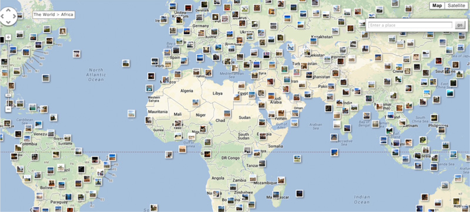
Screenshot of a map of user-generated panoramic photographs in 360cities.com; 360cities is available at 360cities.net
Conclusion
The aspects of scale and movement I have examined thus far with respect to the organization and experience of virtual travels allow us to see the small-screen panoramas as bringing about a set of interlocked ambivalences: an ambivalence of immobility and mobility, of illusionism and compositing, of human vision and programmed vision, of freedom and control, of mastery and play, of isolated and collective, and of visual and haptic. While the coexistence of all the opposite things may be more or less applied to all technical arrangement of panorama as a form of vision throughout media history, I would suggest that the tensions between them stand out when new media apparatuses remediate – both adopt and transform – not simply the forms and techniques of old media but also their modes of vision, spectatorship and their cultural and social uses. The propagation of small-screen devices and mobile networks has propelled the forms of navigation and mobility that were originally grounded in the large-screen, engrossing forms of visual spectacle, to be dislocated and repositioned in new interfaces and contexts, and the small-screen panoramas can be a privileged case of examining the effects that this media transition and the processes of remediation have on our appreciation of the world and our sensorium. As we have seen from the case of small-screen panoramas, these effects bifurcate in two yet also converge: strengthening the effects of old media, and introducing new effects of new media. Then the spectrums of scale and movement in the experiences of small-screen panoramas serve as the litmus paper of the current media landscape where the new and old effects of navigation and mobility contest and negotiate.
Footnotes
Funding
This research received no specific grant from any funding agency in the public, commercial or not-for-profit sectors.