
Abstract
Objective:
This research aims to investigate the effectiveness of wayfinding information (destination reference images) in real-time complex environmental settings through the syntheses of mobile and static information sources. This investigation will help in improving the wayfinding information design for complex institutional environments which will enhance the environmental legibility.
Background:
Complex environments are challenging for wayfinding efficiency. Identification of the location and orientation are considered to be important for wayfinding efficiency. This study investigated the user behavior in synthesizing the wayfinding information for identifying the users’ location and orientation in a complex environment.
Method:
Twenty-five university students have participated in the desktop-based virtual reality experiment. Five experimental conditions were developed for the assessment of wayfinding efficiency and users’ preferred information sources.
Results:
Reference images of destinations with user-matched angles were found more effective than the building’s facade images. Participants synthesized the mobile wayfinding information with real environmental information to identify their location and orientation. Real environment information (road intersections and shape of the road) and mobile information (reference images of building facades) were found influential in the identification of the user’s location and orientation.
Conclusions:
The study suggested a need for thorough investigation regarding the users’ wayfinding behavior with different types of environmental information. Future studies have been recommended to investigate other complex institutional environments with larger sample groups for enhancing environmental legibility and institutional efficiency.
Wayfinding is an activity of finding the destination having the shortest route by gathering information (distance, survey knowledge, and route planning) from environmental information sources (Cheung, 2006). The task of wayfinding uses certain sensory and motor-related skills which use a significant part of the brain (Epstein et al., 2017; Javadi et al., 2017). The efficient usage of these skills majorly depends on the user’s behavior during the wayfinding task. Human behavior in wayfinding tasks has been explored in various aspects like the role of environmental aids (Iftikhar, Asghar, et al., 2020a; Rodrigues et al., 2018; Wiener et al., 2009), layout planning (Hidayetoglu et al., 2010; Natapov et al., 2015), cultural and individual differences (Carrillo et al., 2014; Foster & Afzalnia, 2005; Iftikhar, Asghar, et al., 2020b), environmental and spatial factors (Downs, 2001; Schneider & Taylor, 1999), and wayfinding information (Holscher et al., 2007; Kuliga et al., 2019; Rodrigues et al., 2018). The wayfinding tasks along with the ascribed user behavior are very influential in enhancing the wayfinding efficiency of public institutional environments. Several metrics indicate the wayfinding efficiency like time taken for completing the wayfinding tasks, number of errors during the tasks and use of information sources. Wayfinding efficiency can be investigated by examining wayfinders’ decision-making and problem-solving activities (Rodrigues et al., 2018).
Environmental Characteristics
Complex institutional environments are quite challenging for finding the required facilities especially if the environment is new to the users or difficult to memorize. Wayfinding in complex environments is a difficult task for newcomers and persons who are unfamiliar with the environment (Chang, 2013; Fewings, 2001; Holscher & Brosamle, 2007). The wayfinding activity is also important in healthcare facilities which is directly affecting the professional time of visitors and staff members (Pati et al., 2015). The lack of finding their destination on time due to wayfinding problems elevates the frustration and physical fatigue in visitors as well as patients. Owing to this, the organizational professional workflow is affected (Carpman & Grant, 2001). Several studies (Huelat, 2007; Iftikhar, Asghar, et al., 2020a; Iftikhar, Shah, et al., 2020; Lee & Kline, 2011; A. Siegel & White, 1975) have identified the factors affecting users’ wayfinding efficiency, that is, age, gender, culture, cognitive knowledge, information type and information access, and so on.
In an unfamiliar environment, users need to gather environmental information from dedicated wayfinding information sources. One of the primary reasons behind the wayfinding issues is the inefficient delivery of wayfinding information (Dogu & Erkip, 2000). The environmental information is delivered through several sources including but not limited to wayfinding signage (Chambers & Bowman, 2011), maps (He et al., 2014), landmarks (Rechel et al., 2009), and digital wayfinding applications (Vandenberg et al., 2016).
Wayfinding Information Systems
Wayfinding information systems are facilitating the wayfinding needs through static mediums (i.e., signage, interactive kiosks, and information maps) and mobile mediums (i.e., NFC tags, global positioning systems [GPS], and mobile wayfinding applications). Static information systems like signage and printed maps are proved to be an excellent aid for navigators for wayfinding (He et al., 2014). However, certain aspects need to be considered before designing the information and its placements. Signage and other environmental information can affect the acquiring of wayfinding information, if not effectively designed and thoughtfully placed (Rechel et al., 2009; Sadek, 2015). Due to this, navigators need to rely on memorizing the route or actively exploring the environment to find the destination.
Mobile wayfinding information systems use smart devices to deliver the required information. With the advent of technological advancements, the number of smart device users is increasing globally (Devlin, 2014). A new normal has been perceived that smartphone is meant to be with the users every hour of the day. Owing to this, most everyday tasks have been shifted toward their digital alternatives especially wayfinding (Rodriguez-Sanchez et al., 2014). Digital wayfinding applications can deliver the required information more effectively with the ease of portability (Vandenberg et al., 2016). These digital applications use GPS to identify the users’ current location and orientation (Kaasinen, 2003; Török et al., 2018), therefore they are considered to be the personal wayfinding assistant (Reilly et al., 2009). The mobile wayfinding information usually provides the user’s current location along with the reference images of the destination (i.e., 3D models, destination facade images, and landmarks). This reference information is quite useful in increasing the efficiency of wayfinding tasks (Hoe et al., 2017).
Wayfinding Tasks
The wayfinding tasks include the starting point, walking, decision points, and reaching the destination, which requires participants to gather information from environmental sources and utilize them for identifying their current location and orientation. This location identification further helped them to devise wayfinding strategies and actions. While performing the wayfinding tasks, users tend to synthesize static and digital information for identifying their current position (Iftikhar & Luximon, 2022; Jeffrey, 2017). Wayfinding information through the syntheses of static and mobile information sources is influential in the task efficiency, however, the user behavior in the complex environments for such syntheses has yet to be explored. Owing to this, an exploratory study has been planned to investigate the users’ information synthesis for wayfinding to identify their location and orientation. The study also tried to investigate the preferred sources of wayfinding information at the decision points in complex outdoor environments.
The location and orientation identification has been considered very influential in all of the wayfinding tasks. Wayfinding information, if presented in the form of images would perform better during navigation tasks (Cheung, 2006). Therefore, in this study, an experiment has been designed to investigate the role of reference images of the destination along with the environmental information sources in identifying location and orientation. Owing to this, two hypotheses have been designed to explore the influence of environmental information and user synthesis behavior.
Method
An experimental study has been conducted based on the suggested wayfinding information requirement using wayfinding performance as a metric. Twenty-five male university students participated in this study. The study has been performed using a desktop-based virtual reality setup. The participants performed five wayfinding tasks, each, within an unknown institutional complex outdoor environment. Based on the hypothesis, the participants were analyzed for their performance.
This study aimed to investigate the effectiveness of destination reference images in complex outdoor environmental settings for wayfinding efficiency. From the said argument, the user’s current location has been identified as the significant and most influential factor. Therefore, this factor was considered to be tested in this study with the variety of different information settings provided to the wayfinders. Owing to this, a desktop-based virtual reality experiment has been designed using 360° panoramic images of the real institutional environment. Each participant performed five wayfinding tasks, and their performance has been measured by the time taken and the number of errors. The experiment was performed in three stages, that is, preexperiment questionnaire (sense of direction scale), performing wayfinding tasks, and postexperiment interview for the ascribed actions. For this study, the data have been recorded in the form of the Likert-type scale along with the screen recording and voice recording for the experiment and interview, respectively.
In addition to that, trial wayfinding tasks were also designed and practiced by the participants to familiarize themselves with the experimental setup. Participants were also required to report the Santa Barbara Sense of Direction Scale (SBSDS) and wayfinding application usage before starting the experiment. The complete procedure of trials and actual experiments has been explained to the participants, and they were given a 5-min practice time before the experiment. A consent form has been signed by the participants for taking part in the research study, and they were given a cash incentive for their cooperation. Necessary ethical approval has been obtained from the relevant authorities, and special precautionary measures have also been taken due to the COVID-19 pandemic.
Participants
Twenty-five participants were invited from a reputed higher education institute situated in the city center of Hong Kong. All the participants were informed via a participant induction poster requiring male Chinese participants with a specific limitation on age-group (18–35). Only male participants were invited to the experiment to avoid gender influences while performing wayfinding tasks as predicted from the previous literature as well (Coluccia & Louse, 2004; Iftikhar, Asghar, et al., 2020b, 2020a; Iftikhar & Luximon, 2022; Lawton & Kallai, 2002; Waller et al., 1998). Some of these studies also supported the cultural influences on human wayfinding behavior. For that reason, only Chinese participants were inducted into the experiment. The participants were informed before about the desktop-based virtual reality experiment. All the participants were quite well aware of the computer basics and virtual reality.
Preexperiment
Preexperiment Questionnaire.
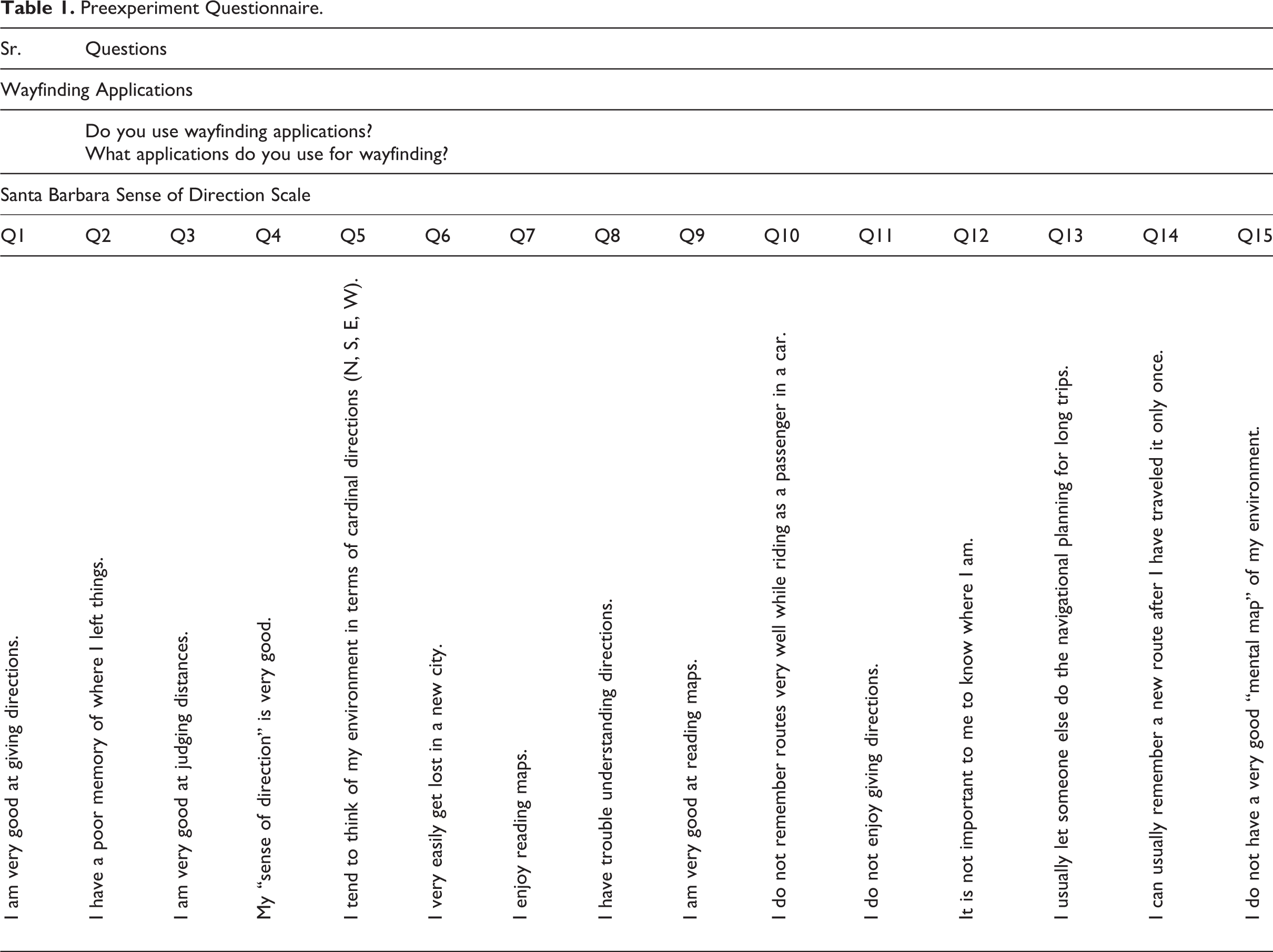
The participants were asked to report the Sense of Direction Scale to measure their spatial ability. The SBSDS (Hegarty et al., 2002) has been used in many studies and found effective in measuring spatial ability. In the questionnaire, participants were also asked about their prior usage of wayfinding applications, that is, Google Maps, Baidu maps, and Apple maps. The details of questions asked by the participants have been presented in Table 1. The first two questions were related to the usage of wayfinding applications, whereas the remaining questions have been taken from the SBSDS. The questions from SBSDS have been presented in the bipolar Likert-type scale, having strongly agreed and strongly disagreed on the poles. The data have been collected using the online service of Microsoft Forms.
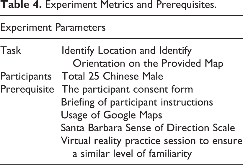
Experiment Parameters
The wayfinding experiment has been designed to evaluate the participants’ information requirements while performing the wayfinding tasks. As proposed in the previous literature, the wayfinding information synthesis suggested the synchronized use of mobile and static wayfinding information. This experiment simulated the suggested environment and required the participants to perform wayfinding tasks using the desktop-based virtual reality system. After completing the initial questionnaire regarding their spatial ability and usage of wayfinding applications, they were introduced to the experimental procedure. Researchers demonstrated the experimental procedure with the trial setups in front of the participants. Participants were also given 5 min to practice the method for identifying their location and exploring the virtual environment. The participants were given five different and unknown outdoor locations inside the educational institution. They were allowed to take their time in identifying their location. Once the task is completed, they were directed toward the following location by the researchers.
Equipment
The experiment has been conducted using the HP desktop (Core i7, fifth gen., dedicated graphics memory 8 GB) and dual monitor screens having a screen resolution of 1,920 × 1,080. Both of the monitors were attached to a single computer as an extended display in addition to the main one. One screen has been used as a mobile information display, and the other has been simulated as a 360° panoramic virtual environment. The panoramic images from an educational institution have been downloaded from Google Maps with relevant Application programming interfaces (APIs). The panoramic images have been converted into a 360° spherical navigable environment using a cloud-based virtual tour software known as LAPENTOR.
For the mobile information, the maps have been created using Adobe Illustrator 2021 and Adobe Photoshop 2021. The participants can view all the directions using a mouse pointer and zoom in and out to see the details in the real environment. Similarly, for the mobile information, the zooming and panning options were also added to see the details.
Design
Experiment Variables.
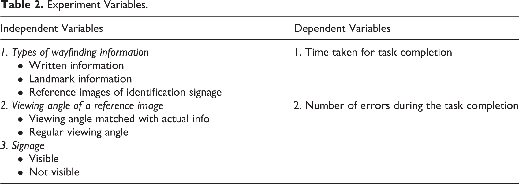
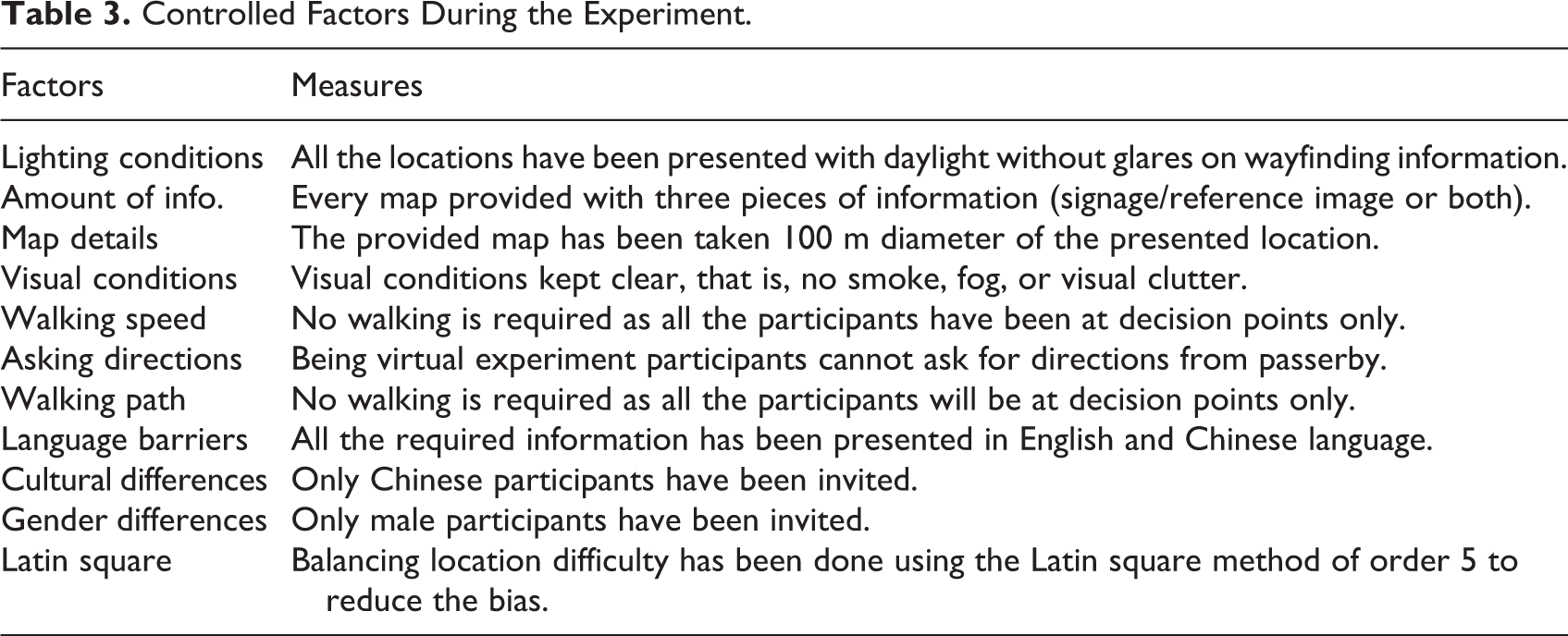
The experiment has been designed with a clear objective, along with independent and dependent variables that have been defined accordingly in Table 2. During the whole experiment, certain factors have been controlled for confounding elements. These factors have been delineated in Table 3. The factors start with the lighting conditions of the experimental settings, which have been kept to daylight time. The amount of information has been kept constant by providing an equal amount of information throughout all the conditions. The given map has provided the information for a selected diameter which is presented in the table. Walking speed, path complexity, and asking directions were considered confounding in the previous studies. In response to that, these factors have been kept constant in the virtual environment for a reliable causal relationship between the type of information and the participants’ performance. The most critical parameter has been balanced, which is the different difficulty levels of the testing environment. The Latin square method has been used to balance this bias.
Controlled Factors During the Experiment.
Experiment parameters
In addition to that, specific metrics have been devised to measure the performance of the participants. The first metric was the time taken to complete the respective wayfinding task, along with the number of errors they made while pointing out their current location and orientation on the map. The detailed parameters and metrics have been presented in Table 4.
Experiment Metrics and Prerequisites.
Locations and conditions
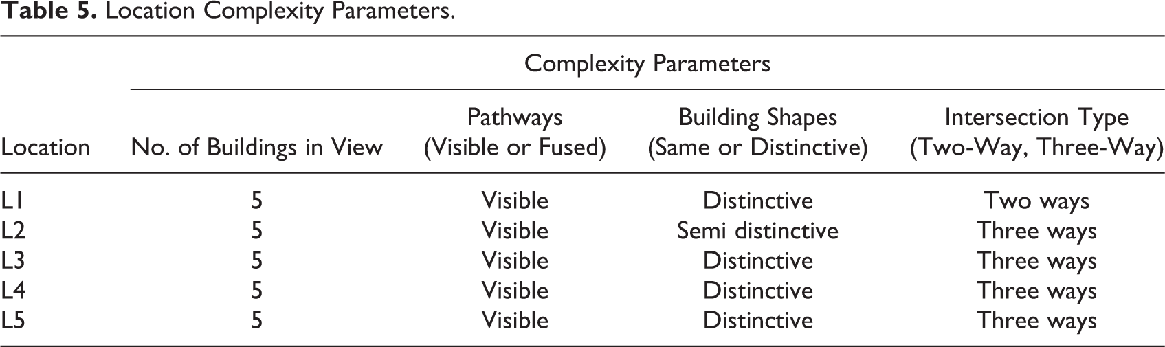
The experiment has been performed using the virtual location of a reputed university in Hong Kong. All the participants have never visited the said university campus before, and they were not familiar with the environmental settings. All the selected locations have been carefully selected while keeping in mind certain elements. The complexity of the selected location can be an influential factor in affecting the participant’s performance and for the increased number of errors. Specific parameters have been devised to cater to this issue before selecting the real outdoor location for our virtual experiment. The parameters have been presented in Table 5. In total, four parameters have been considered significant based on the literature and performed studies. The number of buildings in the experimental settings for each task has been kept constant at five. In addition to that, pathways, building shapes, and the number of intersections were also considered to be essential and kept constant for a uniform complexity throughout the experiment.
Location Complexity Parameters.
After selecting the locations based on the above parameters, experimental conditions have been devised. During the experiment, there were two screens, one for the map information and the other for the 3D virtual environment as depicted in Figure 1. To develop the experimental conditions, a combination of three independent variables has been devised. The combination is consisting of the following parameters (i.e., type of information, viewing angle, and information visibility). Of 24 different combinations, four combinations have been selected as the experimental conditions. To measure the wayfinding effectiveness, a basic set of combinations has also been selected (Condition 1). The details of experimental conditions have been presented in Table 6 and Figure 2. In the mentioned table, certain symbols have opted, that is, landmark (L), signage visible (S1), signage not visible (S0), landmark with facade view (LF), and landmark with user-matched angle (LM).
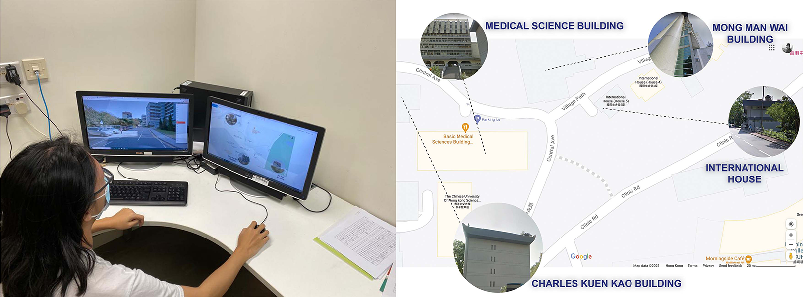
Experimental setup in design lab.
Experimental Conditions.
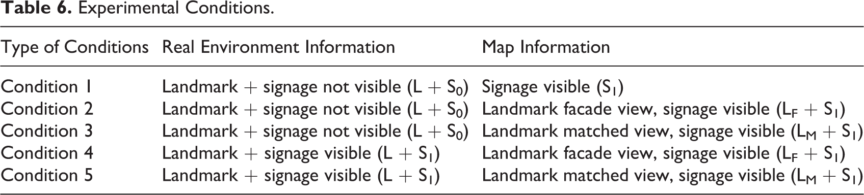
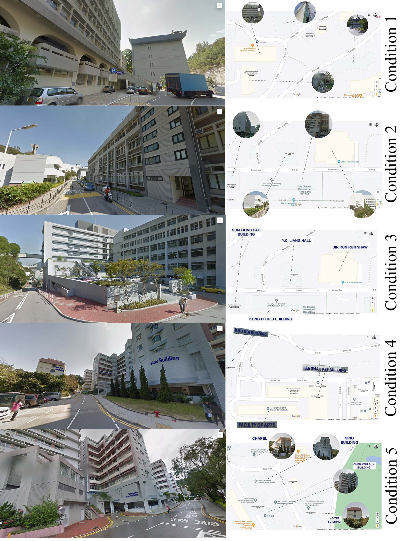
Experimental conditions.
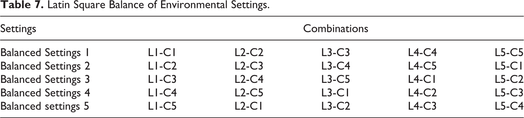
Based on the conditions mentioned above, five locations have been prepared and used for the pilot testing. In the pilot testing, it has been observed that the varying complexity of the environmental settings can influence the wayfinding performance. Owing to this, the Latin Square method has been applied to balance the effect of environmental settings. After applying this balancing method, five balanced settings have been developed, consisting of further five environmental settings in each category. The balancing of environmental settings and information conditions has been presented in Table 7, that is, L1 is Location 1 and C1 is Condition 1. Participants have been presented with these balanced settings, so every balanced setting has been utilized by five participants. Therefore, the experiment will exclusively depict the effects of information change on wayfinding performance.
Latin Square Balance of Environmental Settings.
Procedure
Four environmental settings have been prepared for the participants to practice and familiarize themselves with the experimental procedure. The procedure, along with the practical examples, has been demonstrated to each participant. Once they feel comfortable, they were allowed to practice themselves for 2–3 min. The wayfinding tasks require the participants to identify their location and orientation on the map. For this purpose, participants were allowed to practice so that it cannot be a factor of delay and affect the participant’s performance in any way. After completing the practice session, participants were given the actual balanced environmental settings to identify their location and orientation on the map. Every real environmental setting has been oriented toward the real North; however, the true north was never mentioned on the map information, so the participants cannot guess the orientation information from here. During the experiment, a video-recording device has been placed to record the participants’ actions. Once the task has been completed by the participant, the researcher was responsible for changing the next location information for both, that is, map information and real environment information.
After completing all the tasks, the participants were invited for a short explanatory interview about their actions during the experiment. During the interview, they were asked about the most used information sources and why they have relied on them. In addition to that, the participants were also asked about their desired strategy of searching the way in an unfamiliar environment.
Data analysis
The collected data have been in the form of video recordings. All the video recordings have been analyzed carefully using different methodologies. The wayfinding task time has been observed from the recordings and noted down for every participant. In addition to that, if the participants have made an error while experimenting, then it also has been recorded. Based on the hypotheses mentioned earlier in this chapter, specific statistical techniques have been considered relevant for analyzing the data. All the information conditions have been recorded in the form of time taken. So, the statistical mean and standard deviation of time taken for each condition were calculated for the initial finding of participants’ performance. Before applying any further statistical analysis, the data were checked for normal distribution using Shapiro Wilk’s test of normality. The data were further analyzed using the Related-Samples Wilcoxon Signed Rank test after being found as non-normally distributed. The said test was also used for the combination of conditions which has been further explained in the Results section. To find out the relationship between spatial ability and the participant’s performance, Kendall’s τ correlation test has also been considered appropriate. This test investigated whether participants’ performance and spatial ability have any correlation.
Results
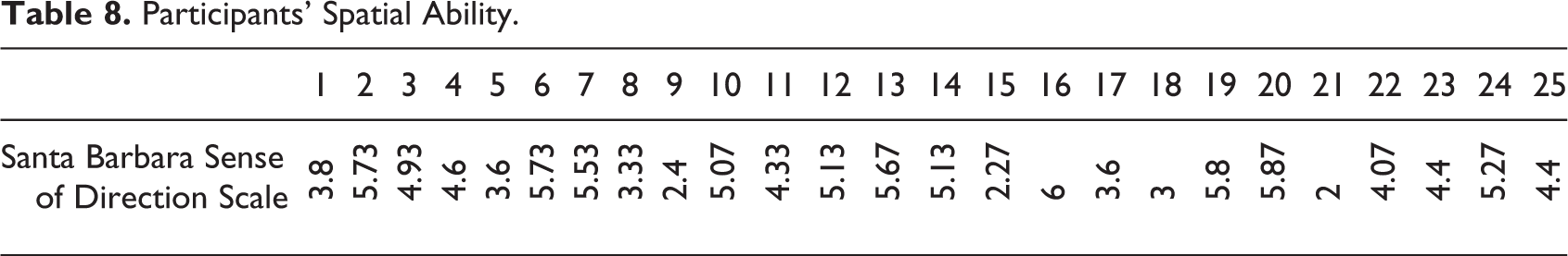
The results of the current study have provided interesting insights regarding wayfinding behavior. Before the experiment, the participants’ spatial ability was calculated using the SBSDS. All of the participants were having a spatial ability more than the neutral range (<3.5) except four participants who have slightly less value in sense of direction scale. The spatial ability scores enunciated that all participants have an adequate ability for wayfinding. Owing to this, the chances of spatial ability being a confounding factor have been minimized. The spatial ability score of each participant has been presented in Table 8.
Participants’ Spatial Ability.
In this experiment, the participants’ wayfinding performance was recorded with the change in information conditions. The performance has been measured using the time taken while performing the wayfinding tasks. The representation of the overall time taken has been presented in Figure 3. In the respective figure, each participant has been mapped according to the time taken against the provided experimental conditions. Every participant showed relative efficiency for task completion in Experimental Condition 5 where reference images have been presented at user-matched angles on the map and the visible signage in the real environment.
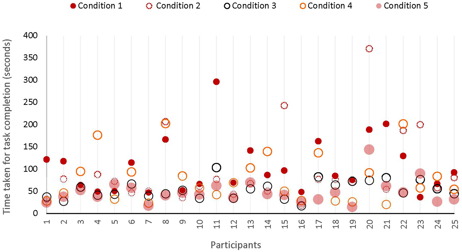
Participants’ individual task completion time in experimental conditions.
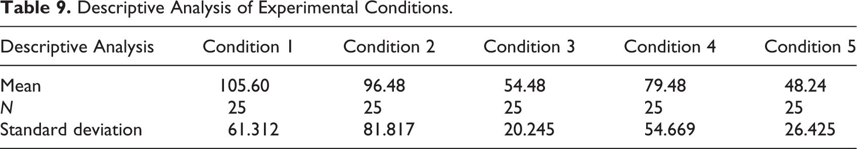
All the conditions have a different set of information which affected their wayfinding performance. To investigate the differences in time taken for the respective conditions, a descriptive analysis has been performed using SPSS software. All the information conditions have been compared using the mean time taken for each condition. As described in Table 9, the highest mean time has been taken for information Condition 1, followed by Condition 2, Condition 3, Condition 4, and Condition 5, respectively. The time difference has suggested that participants have performed better in certain information conditions for completing the wayfinding tasks. However, a detailed statistical investigation is required to understand whether the time differences are statistically significant or not.
Descriptive Analysis of Experimental Conditions.
The data have been non-normally distributed, owing to this, nonparametric tests for related samples have been considered suitable to compare the mean differences, that is, Related-Samples Wilcoxon Signed Rank Test (S. Siegel, 1956). The said test has been applied to compare each information condition with other conditions and to investigate whether there are statistical differences or not. The results showed some interesting facts because all the conditions were not statistically different from each other, contrary to the expectations from Table 9. The performance in Condition 1 is statistically similar to Condition 2 having a p value = .270, which is higher than the significant value (p ≤ .05). Similarly, Condition 1 with Condition 4, Condition 2 with Condition 4, and Condition 3 with Condition 5 are statistically similar to each other, having a p value equal to .113, .716, and .166, respectively, which is relatively higher than the significant p value as presented in Table 10.
10. Statistical Analysis of Experimental Conditions.
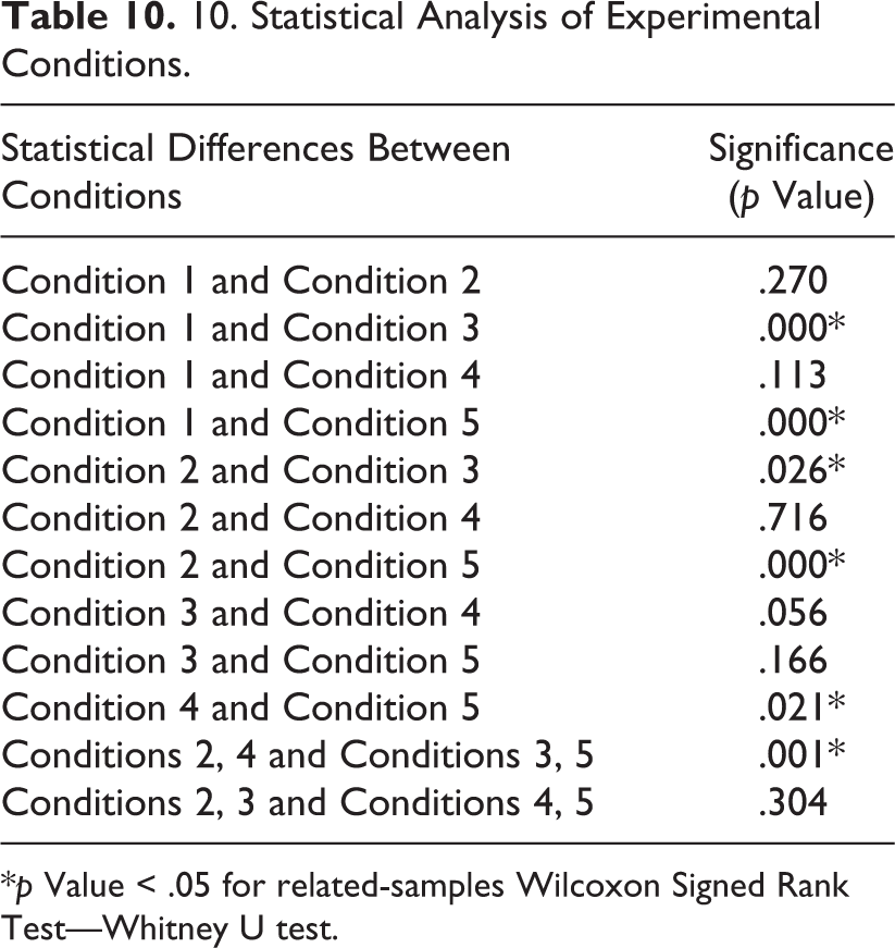
*p Value < .05 for related-samples Wilcoxon Signed Rank Test—Whitney U test.
In addition to that, the p value for Condition 1 and Condition 3 has been reported significant where the p value equals .000. Similarly, Condition 1 with Condition 5, Condition 2 with Condition 3, Condition 2 with Condition 5, and Condition 4 with Condition 5 are significantly different from each other, having the p values equal to .000, .026, .000, and .021. Although the mean time taken depicted in Table 9 suggested the performance variation, the statistical test suggested that some conditions are not different from each other. Moreover, the conditions mentioned in Table 6 have signage visibility and reference image information as key variables to understand the impact on wayfinding performance. Owing to this, Condition 2 and Condition 4 have been combined and compared with Condition 3 and Condition 5. In the combined Conditions 2 and 4. the reference images have been presented in the facade view. Whereas, in Conditions 3 and 5, the reference images have been presented in the user-matched angles.
Similarly, Condition 2 and Condition 3 have been combined and analyzed with Condition 3 and Condition 4. In both of the condition combinations, the difference is in signage visibility in the real environment. In Conditions 2 and 3, the signage is not visible in the real environment, whereas in the other two conditions, it is vice versa. The related sample Wilcoxon test has been applied to investigate the relationship of information variance with the wayfinding performance. The combination of Conditions 2 and 4 has been statistically different from the combination of Conditions 3 and 5. This notion can be easily seen where the p values are equals to .001, which is statistically significant (p ≤ .05). For the condition combination of 2 and 3 with a condition combination of 4 and 5, the performance difference is not significant because the p value equals .304.
In addition to that, participants’ spatial ability has also been analyzed with their wayfinding performance. The spatial ability can also be the confounding factor affecting the performance instead of the information variation in the static or mobile information. The individual’s spatial ability has been collated with the total time taken. As the data were non-normally distributed, Kendall’s τ test of correlation was considered suitable for this purpose. The participant’s spatial ability and total time taken for the wayfinding tasks were not significantly correlated (p value = .123). This implies that the spatial ability did not affect the findings of the said experiment and the time taken for performing the wayfinding tasks is solely spent on synthesizing the provided wayfinding information.
During the postexperiment interview, all the participants mentioned several essential wayfinding aids which were quite helpful for them while performing the wayfinding tasks. All the mentioned information sources have been transcribed and coded into generic categories. The information categories have been converted into a word cloud based on the frequencies mentioned by the participants. The preferred sources for information have consisted of the shape of roads in the real and map environment, road intersections, landmark reference images in the map information, and building facade in the real environment as presented in Figure 4.
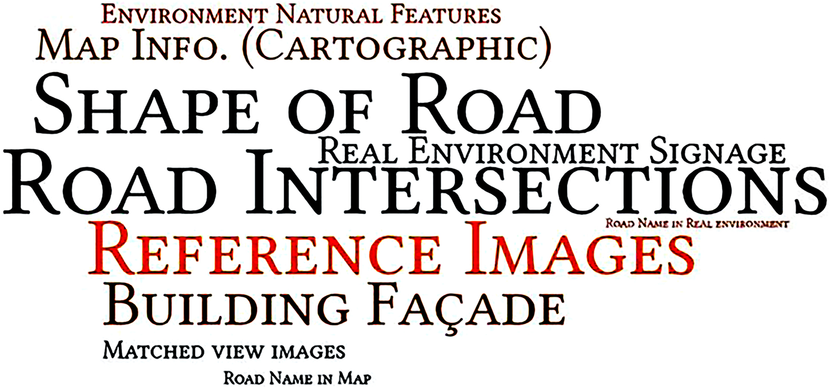
Preferred information sources for wayfinding.
Discussion
The mean comparison of the information conditions and statistical differences have been influential in describing the factors which can affect the wayfinding performance of the participants. In Table 9, the overall mean comparison of information conditions clearly described that the wayfinding performance had been lowest with the information Condition 1 followed by Condition 2, Condition 4, Condition 3, and Condition 5, respectively. However, the most effective and efficient information condition cannot only be found by the mean comparison of the time taken. To see the overall performance distribution among all of the participants, it was considered necessary to perform the Wilcoxon rank test for the mean comparison. The respective statistical test investigated the said argument in detail. In the previous section of this study, the hypothesis described that the user-matched angle reference images are more efficient in increasing the wayfinding performance than the regular facade reference images.
As the statistical test suggested, the performance (time taken for task completion) of Condition 1, Condition 2, and Condition 4 are somehow not significantly different from each other. This argument suggests that the information conditions presented in these three conditions almost have a similar impact on the participant’s wayfinding performance. On the other hand, the performance of Condition 3 and Condition 5 are quite similar to each other but significantly more efficient than Conditions 1, 2, and 4. In three conditions (1, 2, and 4), reference images (facade view) were provided on the map information as described in Table 6. While in Conditions 3 and 5, reference images in the map information were from the user-matched angles. The effect of the signage variable on performance is not significant, however, the effect of the viewing angle of a reference image on performance is significant. Users performed better if the reference images of environmental information provided in the map are of user-matched angles instead of facade view.
As an overall discussion, the results can be summed up to the statement, that is, (performance of Condition 5 = Condition 3 > Condition 4 = Condition 2 = Condition 1). This relationship has proved the mentioned Hypotheses 1 and 2 about the reference images. In addition to that, two of the information conditions (2 and 3) have no signage visibility in the real environment, whereas the Conditions (4 and 5) have visible signage in the real environment. To further investigate whether signage visibility can significantly affect wayfinding performance, the two sets of conditions have been combined, as stated in the Results section. The results enunciated that, Conditions 3 and 5 are statistically better than Conditions 2 and 4; however, Conditions 2 and 3 have no significant performance differences from Conditions 4 and 5. This notion can be influential in proving that reference images if matched with the user’s viewing angle can increase the wayfinding performance. This argument has been partially consistent with the previous study (Cheung, 2006), where image information performed better in navigation tasks. However, regarding the facade images or user-matched angle images, no particular information has been studied before in the literature.
In addition to that, 3D models of landmarks can also be influential as presented in the previous studies (Hoe et al., 2017; Klatzky et al., 2008; Shelton & Hedley, 2004). However, the presented 3D models have a very different view compared to the user’s human eye view. Owing to this, 3D models would be able to perform similar to the facade images as depicted in our study. A similar study (Xia et al., 2008) has also described that images of particular landmarks from eye level are influential in enhancing orientation and navigation performance. The wayfinding performance in our study was not affected by the visibility of identification signage in the real environment. The signage visibility was considered important in synthesizing the map and real environment information, however, participants considered reference images of landmarks more important.
Although the studies (Gibson, 2009; Oyelola, 2014) suggested that identification signage is extremely useful in public spaces for identifying the destination, however, in our study, due to the presence of mobile map information, the identification signage in the real environment was considered less important. Because in the map information, it is quite difficult to validate the information in the real environment just by seeing the identification signage. Maybe it can give the idea of location proximity; however, it cannot give the exact direction and orientation in the real environment. After the experiment, the participants mentioned their preferred wayfinding information sources as per their practice and comfortability.
As discussed earlier, the most preferred information source is the shape or patterns of the road. This finding has been considered consistent with previous studies (Carlson et al., 2010; Hölscher et al., 2009; Wolbers & Hegarty, 2010) where the shape of the road was quite influential for the participants. In addition to that, road intersections are also considered to be very influential when performing wayfinding tasks. Our finding has also been consistent with the previous studies (Asher et al., 2013; Clarke et al., 2013). However, in both of the information aids, the intersection is also a decision point for a wayfinding task, that is, either to continue in the same orientation or need to change it. After that, the reference images of landmarks are very important in guiding the navigators. In previous studies (Cornell & Greidanus, 2006; Omer & Goldblatt, 2007), the role of landmarks in wayfinding have been investigated. In our study, the reference images to identify the landmarks in a real environment have been investigated and found effective while performing the wayfinding tasks.
Conclusion
The wayfinding information in the real environment (static) or in the mobile platforms is helpful as a wayfinding aid when the environment is simple. For the complex, congested institutional public environment, these information aids are not effective enough to guide the navigators. Owing to this, an information synthesis of static and mobile wayfinding information is required to inform the navigators effectively and also for the validation of provided information in the real environment. For information synthesis, only the role of reference images and signage visibility have been investigated for this study. The reference images with the user-matched angles are more efficient than the reference images of the building facade.
On the other hand, the signage visibility in the real environment has no significant influence on participants’ wayfinding performance. It is also recommended to explore other wayfinding information aids for information synthesis. The wayfinding information synthesis for static and mobile information can be proven efficient in comparison to the existing wayfinding strategies, especially for complex outdoor environments. This study also suggested exploring users’ cultural and individual differences for wayfinding information syntheses in complex environments to develop a systematic framework for wayfinding information requirements.
Implications for Design and Practitioners
Complex environmental settings require a multisource wayfinding system. Wayfinding information synthesis is needed to understand the environment. Wayfinding information needs to be designed by synthesizing both static and mobile information systems. For the efficient completion of wayfinding tasks, identification of one’s location and orientation is necessary. Information designers need to develop the validation source in real environment for all the provided wayfinding information.
Footnotes
Declaration of Conflicting Interests
The author(s) declared no potential conflicts of interest with respect to the research, authorship, and/or publication of this article.
Funding
The author(s) disclosed receipt of the following financial support for the research, authorship, and/or publication of this article: This study was supported by The Hong Kong Polytechnic University, Hong Kong, having grant no. RL6A as part of the PhD research project.