
Abstract
Recurring climatic and non-climatic hazards, combined with state negligence, challenge resource security for communities already burdened by environmental injustices. Grounded in community-based participatory research (CBPR) and action research (AR) traditions, this article reports results from a 3-year partnership with local leaders in Corcovada, Puerto Rico, to understand the relationships between food, energy, and water (FEW) security and community health in the wake of compounding hazards and disasters. Here, and elsewhere in Puerto Rico, environmental deregulation and state abandonment forces local leaders and community-based organizations into becoming the first responders for community-scale FEW insecurities. We conducted a participatory mapping exercise with 16 community leaders to co-learn about local experiences and response efforts after recurring hazards and disasters between 2011 and 2021. Participatory mapping facilitated a horizontal learning process to understand and communicate the interconnections between FEW insecurities and physical and social infrastructures, developing opportunities for knowledge co-production, capacity-building, and education at these intersections. Our partnership continues to strengthen community leadership in local decision-making, disaster mitigation, and resource management and allocation—and contributes a problem-oriented AR case for supporting frontline communities.
INTRODUCTION
Food, energy, and water (FEW) security is required for basic public health and well-being. When FEW resource access is inadequate or insecure, worsened mental and physical health outcomes may occur. 1 Moreover, these resource insecurities are reinforcing of one another 2 , holding the potential to compound public health challenges. 3
The ongoing colonization and neglect of Puerto Rico by the United States, paired with western-driven climate change, creates a political-economic context of extraction and underinvestment, skyrocketing debt, and inadequate aid in the wake of disasters. 4 State negligence, evident in the failures to repair or upgrade water and energy infrastructure, the lack of recognition from resource management authorities, and the exclusion of community knowledge in decision-making processes, all undermine community wellbeing and survival. 5 As a result, impacts (e.g., power outages) associated with even “weaker” natural hazards are felt intensively, as was the case with Category 1 Hurricane Fiona in 2022. 6 Thus, hazards and disasters worsen existing FEW risks, particularly in underserved communities. 7 In Puerto Rico, these complex administrative burdens often force communities to respond to FEW insecurities and sustain FEW systems.
Participatory research methods are well positioned to connect the impacts of FEW insecurities to larger societal and political determinants of health by including those directly impacted to participate and inform research directions and products. 8 Drawing from Participatory Action Research (PAR) and Community-based Participatory Research (CBPR) traditions, a community-driven participatory mapping exercise was conducted in the community of Corcovada (Municipality of Añasco, Puerto Rico). Corcovada is a rural community with a history of community organizing and collective action. For example, the community constructed its aqueduct over 40 years ago and has managed it independently since. 9 In addition, they have brought social programs and addressed infrastructure challenges in their community. 10 However, the community is at risk from hazards such as landslides, earthquakes, and flooding which, along with state disinvestment, increase the risks of FEW insecurities. Partnering with rightsholders at the forefront of local response, such as community leaders, provides the opportunity to recognize, validate, and challenge the larger, structural forces that shape place-based vulnerabilities and resource insecurities. This process can include community-engaged research outputs for public health, disaster emergency management, and social vulnerability reduction. 11
Aligned with climate and environmental justice principles such as equal partnerships, education on social and environmental issues, and fair access to resources, 12 CBPR and PAR frameworks center the experiences and creative actions of communities to strengthen resource governance and management from climate change impacts. 13 In the context of FEW (in)securities, bringing together CBPR and PAR provides an opportunity to better understand community partner needs through inquiry, action, and reflection in the quest for positive change. 14 As such, our research partnership in Corcovada explored the following questions: what social and physical infrastructures and resources do community leaders identify as important for addressing resource insecurity following a disaster? What challenges do these resources encounter across multiple hazard and disaster contexts? In what ways does the community address disaster impacts, such as FEW insecurities, when the state fails to respond?
Participatory mapping as a methodological approach
Participatory mapping emerged in the 1990s as a response to conventional top-down mapping exercises. 15 Historically, cartographers developed maps, which reflected and imbued significant relations of power and knowledge, including decisions of land use, representation, and usability. 16 Social activists, technological access, and advancements in mapping tools, such as open-source mapping resources, enabled “non-cartographers” to explore people’s experiences through physical, socio-cultural, political, and economic dimensions. 17 This practice gained the interest of scholars, grassroots organizations, and communities for centering local knowledges to inform, identify, or influence spatial decisions by foregrounding “the relationship between a place and local communities through the use of cartography.” 18 Through such processes, participants can map the prioritizations of risk in geographically-bounded areas. 19
Prioritizing local perspectives stimulates reflection and conversation—a crucial step towards more effective resource management. 20 This brings together sociocultural and physical norms, recognizing the need to develop an inclusive environment for all community voices. 21 Accordingly, participatory mapping builds community support through local knowledge, co-learning, and empowerment, aiding in disaster mitigation and emergency response. 22
Participatory mapping is valuable in disaster studies, as well as research related to FEW security. 23 Top-down technocratic hazard mapping omits important information and context, such as local knowledge and experiences, which can be necessary to assess local vulnerability to hazards and disasters. 24 As such, community members provide important expertise for risk reduction, incorporating community-based principles, promoting community trust in science, and facilitating engagement. 25 Overall, maps co-developed through these methods serve as a disaster mitigation resource, aiding in the management of vulnerabilities and leveraging local resources. 26
While participatory mapping has advantages, scholars note that it is not always utilized to empower residents. Past research has used participatory mapping exercises with the primary intention of data collection and has restricted its access for community members. 27 In other cases, participatory maps have been used to coerce public support or make important community decisions without centering values of social and environmental health—potentially reproducing inequities. 28 Additional pitfalls of participatory mapping include the tendency to focus on the technical side of the mapping experience and overriding or omitting political, social, economic, or cultural dimensions of lived experience. 29 Although participatory mapping can potentially lead to local empowerment and social change, it is dependent on “how these processes occur, for whom, and for how long.” 30
MATERIALS AND METHODS
Our mapping exercise adopts a mixed-methods approach linking group discussions with the spatial identification of resources.
31
We sought to incorporate considerations on FEW systems, as well as the community’s experiences with hazards, disasters, and public health. As stated earlier, we guided our participatory mapping exercise and research with the following questions:
What social and physical infrastructures and resources do community leaders identify for addressing resource security following a disaster? What challenges do these resources encounter across multiple hazards and disasters experienced in the community? In what ways does the community address disaster impacts, such as FEW insecurities, when the state fails to respond?
This research was approved by the Institutional Review Board (IRB) at the University of Maryland, Baltimore County under the application, Environmental Inequaity and Disasters Research (#698).
Study site
In the last decade alone, Puerto Rico experienced a series of events impacting resource availability and access, and the technical resiliency of critical infrastructure systems. The archipelago faces an over $70 billion debt crisis, and the impacts of climatic (e.g., hurricanes, heatwaves, and landslides) and non-climatic hazards (e.g., COVID-19), coupled with the lack of support from the U.S. government, have created an environment of constant precarity for Puerto Ricans. 32 Just one event, the electrical failure in 2017 following Hurricane María constituted the lengthiest blackout in modern U.S. history at the time and severely impacted households, sanitation, and cooking, exposing residents to endemic mosquito-borne diseases and bacterial diseases, such as leptospirosis. 33 The impacts attributable to constant climatic and non-climatic hazards over the past decade presents Puerto Rico as a critical case study to develop collaborations that can aid emergency-driven tools that assess and support community resilience, public health, and environmental justice.
This study focuses on the experiences of residents of Corcovada, a barrio located in the municipality of Añasco on the main island of Puerto Rico. As a small, rural, mountainous community of approximately 630 residents in the Caribbean, Corcovada is at risk of being impacted by hurricanes, landslides, earthquakes, droughts, flooding, and other hazards. 34 At the same time, out-migration, low employment rates, and other structural failures affect this predominantly elderly community. 35 Given the history of autogestion (self-management) in Corcovada to address water injustices, the absence of power for four and a half months after Hurricane María, and active local involvement in responding to community needs such as resource insecurity, 36 having community leaders as co-investigators provided a space to approach these experiences and potential solutions in a more structured and partnership-based way. 37
Participant selection
We conducted two Participatory Mapping Exercises (PME) on February 13 and February 20, 2022, in Corcovada. We used a purposive sampling strategy to select community leaders from diverse socio-economic backgrounds, ages, and leadership roles, such as the community board for the water aqueduct, committees, local businesses, and those who possessed in-depth knowledge about the community. 38 Of the 16 leaders, six identify as female, and ten identify as male. Each PME session involved 16 community leaders with diverse age representation (x̄ = 52.5, range: 25-81).
Data collection
Various measures helped achieve this community mapping exercise. First, we held an interactive lecture and group discussions on defining food security, energy security, water security, the FEW nexus, and its relation to community resilience and community health. This facilitated education on these concepts and established the foundational discussion for the mapping exercises. Then, for the PME, we divided the community leaders into three groups with three maps: one of Corcovada (local) with surrounding municipalities, such as San Sebastián, Las Marías, and Moca (regional); one of the town of Añasco and its nearby municipalities; and one of Puerto Rico (national). In this article, we focus on Corcovada, shown in Figure 1. 39 We provided these groups with six different colored markers for indicating different community resources: green for food resources, red for health resources, blue for water resources, yellow for energy resources, purple for hurricane shelter, and orange for earthquake shelter (see Fig. 2). 40
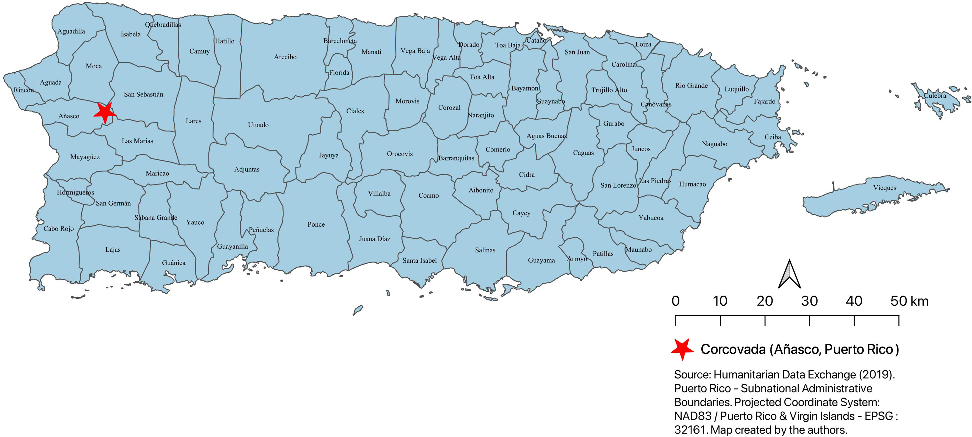
Puerto Rico and the barrio of Corcovada (identified by the marker). Source: Humanitarian Data Exchange (2019). Map created by the authors.
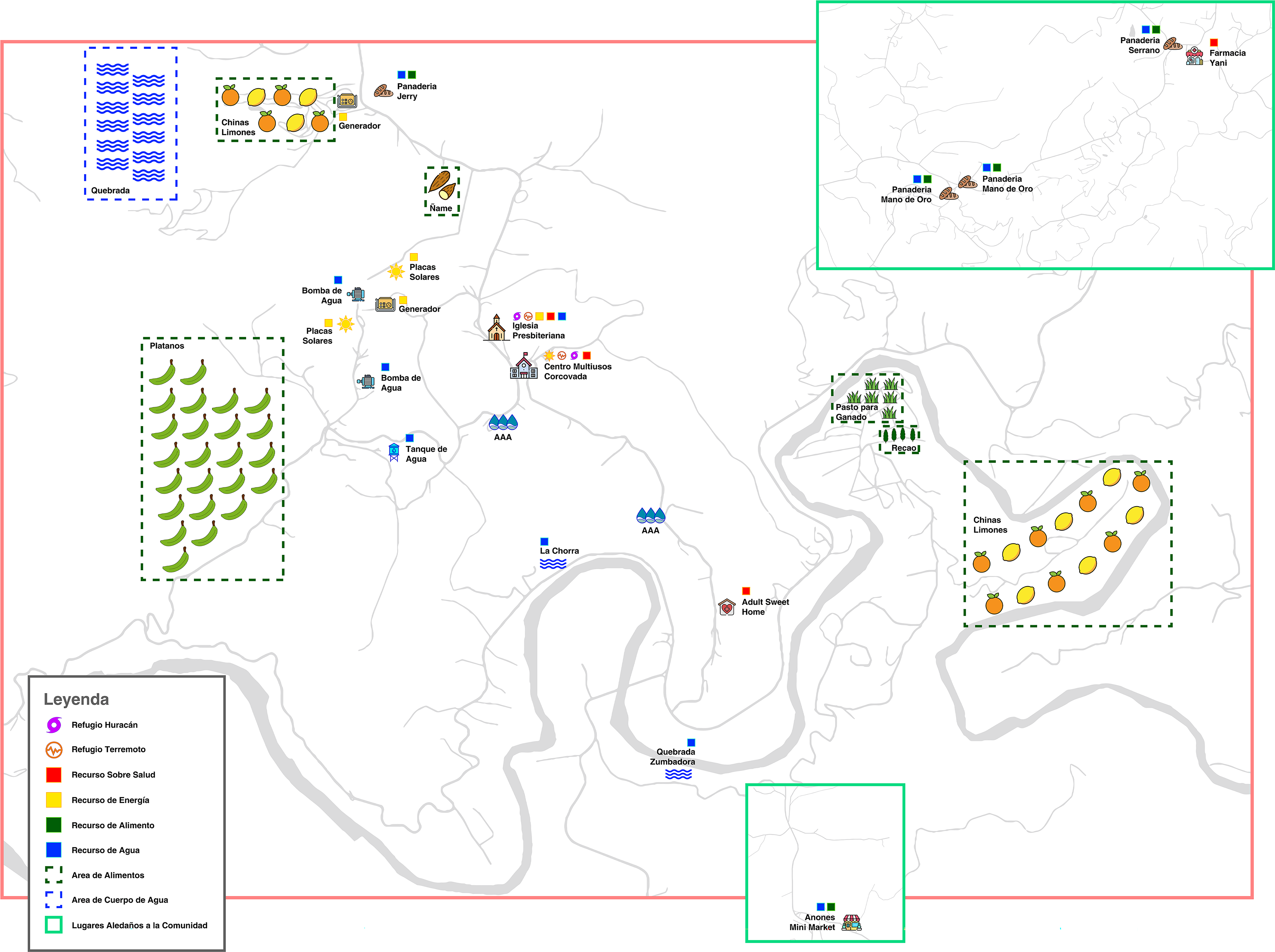
Community map with food, energy, and water resources identified. Image: Sketched by Jan Cordero.
We prompted leaders to map all food, energy, water, and health resources across each map. As part of the exercise, we asked them about these resources during “normal” times and prompted them to consider their experiences across four different climatic or environmental hazards (i.e., drought, flood, landslide, earthquakes) and one non-climatic hazard (COVID-19). To support the diverse experiences and promote active participation across groups, we took into account gender, age, and leadership trajectories in the community. Questions guiding the exercise included: What energy resources does the community have? Do you have an alternative energy system? If traffic roads affect vehicle accessibility to the community, how is water and food acquired? Where do you go to acquire these resources? When the “lockdown” occurred in March 2020, were water, energy, and/or food resources affected? How did the community acquire these services? Where did residents go when services were affected? Such questions were meant to generate reflection among the tables and inform the second component of the PME. For the second PME, a research assistant compiled all maps with the identified resources from all groups to present to the community leaders. In a broader group discussion, the guiding questions from the exercise were used to examine how different climatic and non-climatic hazards have impacted these resources in the past and the potential challenges for future events. This exercise contributes to a culture of inclusive deliberation that places value on a diversity of voices and fosters involvement in practices of autogestion.
Data analysis
To understand the complexities of FEW and social resources, we conducted an analysis on the physical resources and lived experiences of the Corcovada community. We draw from the discussions on the participatory maps community visits, as well as anecdotes of community leaders’ experiences with hazards and disasters over 10 years (2011–2021). We organized the physical resource infrastructure into categories of impact or no impact to understand how different hazards affect FEW resources in the community. By impact we refer to discussions of the hazard occurring in the community, and its influence on FEW resource access, availability, or quality. We generated findings from different activities, including discussions on experiences with hazards and disasters, FEW security challenges, resilience, community health, and social capital. We used inductive coding to identify social resources and the impacts of hazards throughout time. 41
RESULTS
Our results focus on the challenges experienced by the community across four climatic and environmental hazards (landslides, drought, hurricanes, and earthquakes) and one non-climatic hazard (COVID-19). Here, we consider both the social infrastructures (i.e., the relationships within and across the community) and how different hazards impacted physical infrastructures. We focus on the map surrounding Corcovada due to local experiences in disaster management and response. We analyzed how different hazards affect various parts of the community, reinforcing the need for participatory mapping to understand the capacity and impacts across space.
Landslides
Landslides in Corcovada affect road access, and our mapping exercise prompted leaders to discuss their concerns of landslides impacting the local aqueduct. Leaders recalled that in 2015, landslides impacted the water supply, leading the community-led water aqueduct committee to implement a contingency plan mainly consisting of water rationing and other water restrictions (e.g., non-essential water uses) until the damage to the supply system was repaired. Community leaders also discussed that torrential rains from Hurricane María (2017) produced a landslide that completely blocked the entrance to the community—challenging their access to FEW resources. Community members relied on each other, sharing resources such as water and food, while waiting for the local municipality rescue team to come with bulldozers and clear the pathway to Corcovada. Important physical infrastructures, such as the aqueduct system, are at risk during landslides, while social relations can help to mitigate the impacts of resource insecurity or lack of access to important FEW systems.
Drought
Like landslides, droughts pose a direct impact to the community aqueduct system and to overall water security. During our discussion, leaders highlighted previous experiences with the aqueduct, especially with water quantity. One leader indicated that in times when the community experienced drought, reductions in daily water consumption occurred and, subsequently, residents had to purchase water. This brings another challenge for residents, as they usually do not engage in water purchases because the aqueduct is used for both drinking and sanitation purposes. Because of the slow-onset nature of drought, residents do not need to rely on each other as much as in other hazard contexts (e.g., hurricanes) and instead engage in water purchase.
Hurricanes
During Hurricane María, Corcovada experienced strong winds and rains, resulting in landslides and flooding in different places of the community. Winds caused damage to several houses, and residents were without electricity for 127 days, affecting the functioning of the aqueduct system. To operate the community water aqueduct, leaders first relied on gasoline, which was a challenge to access and transport due to the gasoline shortage island-wide and Corcovada’s distance from the nearest gas station (at least a 15-minute car drive). Here, the leaders’ existing relationships with the regional and national non-profit sector provided an opportunity to receive a battery system to operate the aqueduct system with solar energy, reducing the risk of interruptions in the water supply from power disruptions. 42 Due to delays from the government, residents organized themselves to clear pathways to enter the community. Community members used their existing resources to open one area of the community for aid to come and mobilize residents out of the community:
Following Hurricane María, there were people who were making their way out of the community with machete and shovels. Something that almost no one knows, but many of the residents who know what a machete is, for removing grass, going to work […]. The community came together in this way to allow for resources to come into the community.
While an extreme event like Hurricane María impacts infrastructure in the community, the main physical infrastructure identified as at-risk was the baseball park, the basketball court, the water aqueduct, and the local agriculture. Given challenges across the community and leaders' experiences with impactful hurricanes, the multipurpose remodeled school now serves as the main community asset and point of congregation in the wake of hazards. This is now certified as a hurricane shelter for the community.
Earthquakes
On January 6, 2020, the southwestern area of Puerto Rico experienced a magnitude 5.8 earthquake, followed by a magnitude 6.4 earthquake on January 7, 2020, with strong aftershocks recorded with magnitudes greater than 4.5. 43 While the community did not experience any substantial damages from the event, residents felt the earthquakes and expressed concerns about how to respond effectively to such events in order to reduce the need for improvisation. 44 The community has a multipurpose school, community center, and church that have the capacity to serve as a shelter and planning center. Given the unpredictability of the magnitude and location in which an earthquake may occur, physical infrastructures could be impacted. Should an earthquake affect this multi-purpose center, community center, or church, its ability to function as a shelter and planning center would be compromised. As stated by one community leader:
“When we are talking about an earthquake, we are left without communication, we are left with nothing […] the committee group that we already have, more or less, who are going to be supporting the community. They know the place where they are going to arrive so that then that can be the point, because we are not going to have good communication system, right? Maybe there is no way to call, but they already know that the point is the school, the strategic point, because we have the medical office there.”
COVID-19
The COVID-19 global pandemic became a non-climatic hazard that compounded the existing precarity of Corcovada. When discussing community resilience as it relates to the recurrent and diverse hazards and their connections to FEW, leaders discussed how the COVID-19 pandemic impacted their physical ability to be together. This affected their ability to protect themselves under certain hazard contexts due to social distancing mandates. For example, one leader discussed that:
Well, in the hurricanes, we have seen that the community, after making individual arrangements in our houses, with basic necessities we had to be united to respond to the event […]. With COVID we needed to have internet because some of us have children so they couldn’t study without it, right, so that changed, also, the relationships between people stopped […] the distancing, right, and the use of mandatory masks […].
Another leader said, “family relationships were ended by [COVID-19]”. In these examples and others, leaders recognized that while no physical infrastructures were directly damaged by this event, the social relationships in the community eroded. This was also evident as leaders emphasized that these 2-day workshops were the first time they were in a room together since the pandemic began.
DISCUSSION
Hazards can disrupt FEW systems, exposing communities to risks. 45 Addressing these insecurities requires understanding how FEW systems interact with local physical and social structures and resources. Comparing our case to other studies that have examined the FEW nexus utilizing participatory approaches highlights commonalities and unique challenges. For instance, Giatti and colleagues (2022) discuss research projects in vulnerable urban communities in the São Paulo Metropolitan Region, emphasizing the value of centering marginalized groups, such as young residents, to boost engagement and social learning on issues directly affecting them while pursuing sustainable development solutions. 46 Similarly, Uchôa Tavares and colleagues (2021) utilized participatory mapping and a strengths, weaknesses, opportunities, and threats analysis within the Ponta do Urumajó community in Pará state, Brazil. 47 They contend that the strength of this approach lies in identifying the societal, ecological, spatial, and political contexts related to the nexus, prompting a reconsideration of pathways for achieving sustainable development goals. Likewise, in Tulcea (Romania), Balaican and colleagues (2023) found that utilizing participatory methods promotes awareness among stakeholders and decision-makers, presenting intricate connections between water access, energy costs, and food security to ultimately enhance local governance and resource management. 48 These studies underscore the significance of relational and place-based knowledge in addressing FEW challenges.
Our findings contribute to this literature by centering marginalized and frontline actors, such as community leaders, and highlighting the impact of various hazards and disasters on their ability to secure these resources while accounting for both social and technical infrastructures. This community mapping exercise generated opportunities for enhancing social infrastructures within the Corcovada community through leadership gatherings at the workshops. The opportunities for exchange generated through the mapping exercise also provided a space for seeding feelings of hope for enacting collective and cooperative approaches to addressing community challenges. Importantly, as in other participatory mapping exercises in the literature, 49 this process facilitated a horizontal learning process to better understand and communicate the interconnections between FEW insecurities and community health. Furthermore, the participatory mapping exercise used in this study acknowledges that this type of exercise is more than engagement—it serves as a foundation for identifying challenges and strategies in areas marked by persistent disinvestment, structural instability, and autogestión. This aligns with environmental and climate justice principles that call for educational and learning efforts centered on community experiences. 50
The mapping exercise enables community members to leverage their knowledge about FEW (in)securities and injustices and place them in a geographic context to prepare for future events. Across various hazards, the mapping exercise prompted community leaders to discuss challenges related to road damage and transportation more broadly, considering the social (e.g., education and income) and environmental (e.g., hazard impact) vulnerabilities of this community, thus demonstrating the mutual implication and interaction across infrastructures and the inadequacy of treating infrastructures in isolation. As such, while this exercise showed the need to be attentive to physical infrastructures in the community across different hazard impacts, it also highlights the need and value of social relationships and networks to address community needs in the wake of crises. This was particularly present with the COVID-19 pandemic, where physical infrastructures were not directly impacted, but leaders recognized erosion in social relations, which have been central to mitigate previous hazards and disaster impacts. Considering the increased risk for compounding hazards and disasters, evaluating both social and physical infrastructures is an important consideration for collective response and recovery to future events.
Community engagement with the politics of knowledge production can reshape community-led disaster management practices and the distribution of life-sustaining resources, and is a longstanding aspiration of decolonial movements seeking to subvert hierarchies of knowledge generation. 51 Community leadership in FEW infrastructure assessments guards against the threat of uncritically imposing FEW solutions that fail to account for the complexities of the challenges and assets specific to the community, avoiding misinterpretation of how people make meaning of their interactions with FEW systems. By partnering with community leaders, we aimed to advance our understanding of the FEW nexuses at a local level to co-develop applied products residents can use to inform their decisions around disaster preparedness and response.
CONCLUSION
Rural communities encounter heightened risks to their FEW security due to structural, environmental, and socio-political factors. 52 Experiences of government neglect prompted community leaders to spearhead the maintenance of social and built infrastructures to address insecurities in Corcovada, Puerto Rico. Community mapping exercises hold the potential to manage, sustain, and broaden access to FEW infrastructures, as they create greater awareness about the location of community resources and potential obstructions to access through phases of the disaster cycle.
These exercises open opportunities for community-based innovation to address FEW challenges emerging from rich knowledge about local social and built environment vulnerabilities. However, these efforts place substantial administrative burdens on communities currently facing challenges to sustain participation on self-managed projects, involve youth, and motivate lifetime engagement. While community mapping exercises strengthen autogestión, we do not claim that such exercises or autogestión are sufficient to achieve environmental and climate justice. We recognize that autogestión and government-directed advocacy are not mutually exclusive while also acknowledging that sustaining FEW systems will require governments to enact policies based on respect and justice for all peoples. As such, this mapping exercise generated actionable evidence to support community leadership in resource security to support community resiliency under recurring hazards.
AUTHORS’ CONTRIBUTIONS
A.D.R.: Conceptualization, methodology, investigation, analysis, writing—original draft, supervision, funding acquisition. S.H.S.: Conceptualization, writing—original draft, supervision, funding acquisition. M.A.P.: Supervision, writing—original draft. F.T.-A.: Conceptualization, writing—original draft, funding acquisition. E.C.Q.: Investigation, writing—original draft. E.C.Q.: Conceptualization, methodology, investigation, writing—original draft, supervision, funding acquisition. W.P.: Investigation, data curation, writing—original draft. K.D.L.: Investigation, writing—original draft. G.A.C.: Investigation, writing—original draft. E.N.: Writing—original draft.
Footnotes
ACKNOWLEDGMENTS
The authors extend their gratitude to the community of Corcovada and the dedicated community leaders who participated in the workshops. They also extend gratitude to the leaders who are Co-Principal Investigators on this project. The Natural Hazards Center Research Award Program is based on work supported by the National Science Foundation (NSF Award #1635593). This Special Call for Research in U.S. Territories, Tribal Areas, and Rural Communities is made possible through supplemental funding from the Centers for Disease Control and Prevention (CDC). Any opinions, findings, conclusions, or recommendations expressed in this material are those of the authors and do not necessarily reflect the views of the NSF, CDC, or Natural Hazards Center. Our co-author order was informed by the CLEAR (Civic Laboratory for Environmental Action Research) “Equity in Author Order” model (Max Liboiron, Justine Ammendolia, Katharine Winsor, Alex Zahara, Hillary Bradshaw, Jessica Melvin, Charles Mather et al. “Equity in author order: A feminist laboratory’s approach.” Catalyst: Feminism, Theory, Technoscience 3 (2017): 1-17).
AUTHOR DISCLOSURE STATEMENT
No competing financial interests exist.
FUNDING INFORMATION
NSF Award #1635593.