



Abstract
On May 21, 2026, the failure of a methyl methacrylate (MMA) storage tank at GKN Aerospace Transparency Systems in Garden Grove, California, triggered the largest chemical emergency evacuation in recent Orange County history, displacing more than 40,000 residents. This commentary: (1) examines the regulatory conditions that did not provide this community with federal accident-prevention protections that are specifically designed for high-consequence chemical hazards; and (2) presents a systematic environmental justice profile of the affected residential population. While GKN has reported annual emissions to the Toxics Release Inventory (TRI) based on the Emergency Planning and Community Right-to-Know Act, it is not subject to the Risk Management Program (RMP) requirements related to the Clean Air Act because its primary hazardous chemical (MMA) is not listed in the RMP’s enumerated regulated substance list (40 CFR Part 68, Appendix A). The environmental justice analysis focuses on census tracts intersecting the official evacuation zone boundary (n = 54) and is based on data from the American Community Survey 2024 5-year estimates and CalEnviroScreen 4.0 screening tool. Results indicate that racial/ethnic minorities and socioeconomically disadvantaged individuals, as well as linguistically isolated, foreign born, and disabled residents are overrepresented within the evacuation zone, compared to the rest of Orange County. Tracts in the evacuation zone also face substantially higher cumulative environmental burdens. These disproportionate outcomes reflect a structural flaw in the RMP’s enumerated-substance approach and indicate an environmental justice failure with an urgent need for regulatory reform.
INTRODUCTION
At approximately 3:00 PM on May 21, 2026, firefighters in Orange County, California, responded to a report of overheating at GKN Aerospace Transparency Systems, located at 12122 Western Avenue in the city of Garden Grove. A 34,000-gallon storage tank holding about 7000 gallons (∼55,000 pounds) of methyl methacrylate (MMA), a highly flammable, volatile monomer used in the manufacture of aircraft transparencies, had begun to overheat and structurally deform. Declaring the situation a potential explosion and mass-release event, emergency managers issued mandatory evacuation orders covering approximately nine square miles across the cities of Garden Grove, Stanton, Anaheim, Westminster, and Cypress, which led to the displacement of approximately 40,000–50,000 residents. The crisis lasted 5 days before the thermal runaway risk was stabilized and evacuation orders were lifted.1,2 Although no fatalities were reported, the scope of the disruption and the documented absence of federally mandated accident prevention and emergency response planning for the specific chemical involved raise significant concerns about the regulatory framework governing chemical hazards in communities like Garden Grove.
This commentary examines the incident from an environmental justice perspective by exploring two interrelated questions: (1) why a facility with a 38-year history of reporting large quantities of a flammable chemical to federal regulators operated without an accident prevention program required under federal law; and (2) what are the characteristics of the local community that was burdened with the negative consequences of this regulatory limitation. The analysis is based on federal regulatory databases, American Community Survey (ACS) 2024 5-year estimates, and the CalEnviroScreen 4.0 cumulative burden screening tool. This commentary illustrates how the GKN incident is not the product of a facility violation or an enforcement failure, but a consequence of a specific regulatory design choice that systematically excludes large categories of hazardous chemicals from accident-prevention oversight. The burden of this design choice falls, as so often in the history of U.S. environmental regulation, on socially disadvantaged communities with limited capacity to prevent or contest it.
TWO FEDERAL PROGRAMS WITH ONE CRITICAL GAP
The federal framework for managing industrial chemical hazards rests on two parallel but distinct statutory mechanisms. The first, the Toxics Release Inventory (TRI), was established under Section 313 of the Emergency Planning and Community Right-to-Know Act (EPCRA) and is designed to ensure public disclosure of routine and accidental chemical releases to air, land, and water. TRI requires qualifying facilities to submit annual reports on the quantities of listed chemicals they manage, release, and transfer, creating a searchable national database of chronic chemical exposure risks. 3 The second, the Risk Management Program (RMP), operates under Section 112(r) of the Clean Air Act and addresses a categorically different problem: the prevention of catastrophic accidental releases of extremely hazardous substances. RMP-covered facilities must prepare and submit a Risk Management Plan documenting worst-case accident scenarios, prevention programs, and emergency response coordination with local first responders. This information is accessible to community members, emergency planners, and researchers through the Environmental Protection Agency (EPA)’s RMP database and represents the primary federal mechanism for communicating industrial accident risk to affected communities. 4
The critical regulatory distinction is that these two federal programs comprise different chemical lists. TRI covers approximately 770 chemicals and chemical categories,3 while RMP coverage is limited to approximately 140 substances explicitly enumerated in 40 CFR Part 68, Appendix A. 5 MMA (CAS 80-62-6) exemplifies the limitation of these two different chemical lists. MMA is a TRI chemical reportable under EPCRA since the program’s inception. It is a flammable liquid with a flash point of 10°C, a boiling point of 100.5°C, and a lower explosive limit of 2.1% 6 —physical properties that place it within the hazard class that RMP’s flammable substance provisions are designed to address. Since MMA does not appear on the Appendix A list, there is no threshold quantity or RMP obligation, regardless of its on-site inventory.5
GKN Aerospace Transparency Systems (TRI Facility ID: 92641SWDLW12122) has submitted TRI reports continuously since 1988. 7 In the most recent TRI reporting year (2024), GKN reported multiple hazardous chemicals, with MMA as the primary substance at 131,779 pounds of production-related waste managed—more than double of the previous year and the facility’s highest in 30 years.7 The May 2026 incident involved a 34,000-gallon storage tank containing approximately 7000 gallons (∼55,000 pounds) of MMA on site,2 which substantially exceeds the generic 10,000-pound flammable threshold that would trigger RMP obligations if MMA were listed under Appendix A.5 The regulatory consequences of GKN’s non-RMP status implied that no worst-case accident scenario analysis was required, and no RMP-mandated emergency response coordination with local agencies was conducted for MMA specifically. Additionally, the surrounding community had no access to federally mandated accident-risk disclosures through the EPA’s publicly accessible RMP database. The GKN incident cannot thus be attributed to a facility violation or an enforcement failure, since it is a structural aspect of the RMP’s regulatory design.
ENVIRONMENTAL JUSTICE PROFILE OF THE AFFECTED COMMUNITY
To characterize the population impacted by this regulatory gap, all census tracts that are located inside or intersect the Phase 2 mandatory evacuation zone boundary were identified. This rectangular zone comprises Ball Road (north), Trask Avenue (south), Dale Street (east), and Valley View Street (west), as defined by the OCFA Unified Command on May 22, 2026.1 Figure 1 shows the evacuation zone boundary with the 54 included census tracts and the GKN facility location.
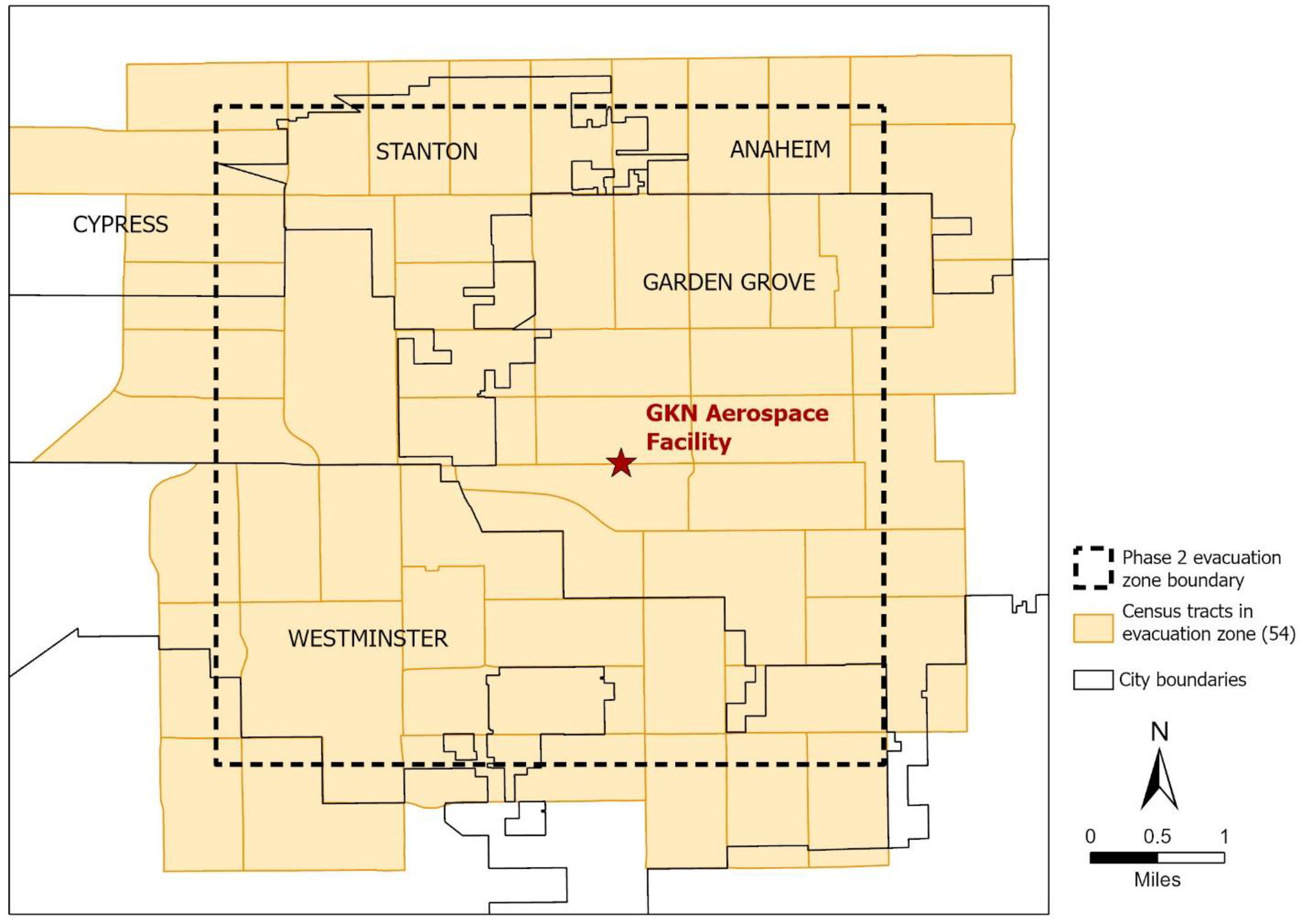
Census tracts in the GKN Aerospace Phase 2 evacuation zone, Garden Grove, California (May 22, 2026).
To examine the environmental justice implications of this incident, sociodemographic and cumulative burden characteristics of tracts in the evacuation zone shown in Figure 1 are compared with those outside this zone (the rest of Orange County). These results are presented in Table 1, which also includes a ratio indicator comparing values in evacuation zone tracts with those outside the zone; ratios greater than 1.0 represent overrepresentation within the evacuation zone.
Comparing Characteristics of Census Tracts in the Evacuation Zone to Other Tracts in Orange County, California (2024)
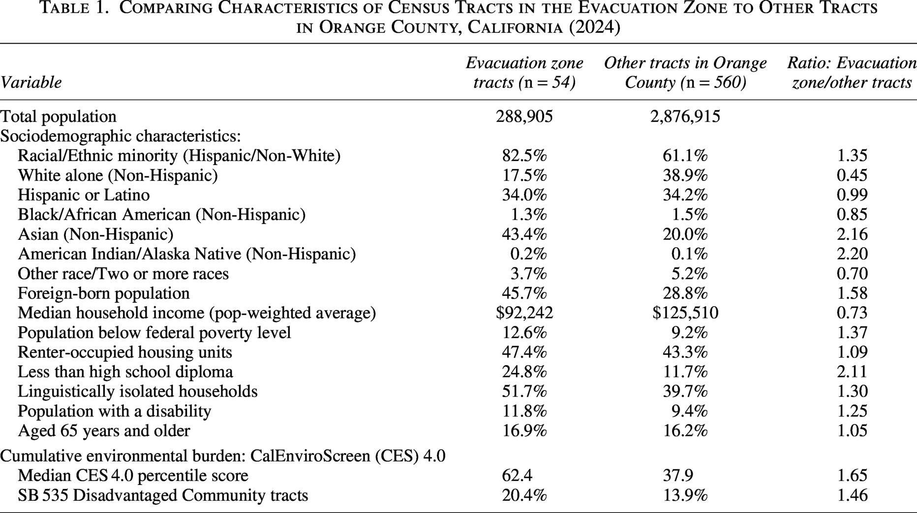
Data on all sociodemographic variables were derived from the ACS 2024 5-year estimates, 8 and cumulative burden indicators were obtained from the Office of Environmental Health Hazard Assessment’s (OEHHA) CalEnviroScreen 4.0 tool. 9 Chi-square tests of independence confirmed that all differences in proportions reported in Table 1 between the evacuation zone versus the rest of the county tracts are statistically significant (p < 0.01).
The 54 tracts in the evacuation zone encompass a total population of approximately 288,905 residents or about 9.1% of the Orange County population. This affected community comprises two large racial/ethnic minority groups. Garden Grove and Stanton are predominantly Hispanic communities, while Westminster contains one of the largest Vietnamese American communities in the United States, centered along the Little Saigon corridor. Across the evacuation zone tracts, 82.5% of residents belong to a racial/ethnic minority group, which is 1.35 times higher than their corresponding percentage in the rest of Orange County (Table 1). Non-Hispanic Asian residents represent the single largest racial/ethnic group in this zone at 43.4%, more than twice their percentage (2.16) outside the zone. Despite their numerical prominence in the affected area, Asian Americans remain an understudied population in environmental justice research, with prior studies documenting their higher exposure to carcinogenic air pollutants nationally.10,11 American Indian/Alaska Native residents, although constituting a small share of the evacuation zone population (0.2%), indicate the highest overrepresentation ratio of any racial/ethnic group in Table 1 (2.20), which aligns with documented patterns of disproportionate Indigenous proximity to industrial environmental hazards elsewhere. 12
Beyond these racial/ethnic disparities, 45.7% of evacuation zone residents are foreign-born, 1.58 times greater than their rate in the comparison area, which could amplify barriers to emergency communication and regulatory participation. 13 Socioeconomic characteristics of the affected community reinforce this trend. Median household income in the evacuation zone is about 27% lower than the Orange County comparison figure. The poverty rate in this zone is considerably higher (1.37), and renter-occupancy is modestly higher (1.09) compared with areas outside the zone, suggesting reduced financial capacity and housing stability among affected residents. 14
Two indicators particularly relevant to the environmental justice dimensions of this incident are linguistic isolation and lower educational attainment, as emphasized in previous studies.15,16 First, 51.7% of evacuation zone households are linguistically isolated (i.e., no one speaks English very well), a rate 1.30 times higher than that in the comparison area. Thus, more than half of the households lacked an English-proficient member to navigate evacuation communications, access emergency resources, or engage with regulatory systems. Second, more than twice the proportion of adults in the evacuation zone did not have a high school diploma relative to other county tracts (Table 1). Both linguistic isolation and lower educational attainment are known to potentially constrain community capacity to access regulatory databases, navigate emergency alert systems, file public comments, or organize in response to industrial hazards, especially among foreign-born residents.13
Disability status represents an additional dimension of vulnerability that is particularly consequential in emergency evacuation contexts. The percentage of the population with a disability in the evacuation zone is 1.25 times higher than that outside the zone. Although disability has received limited attention in previous environmental justice research, this finding is consistent with prior studies showing that disabled individuals are more likely than non-disabled residents to reside near RMP facilities 17 and other pollution sources 18 in Houston, Texas. The complete absence of RMP-mandated emergency planning for MMA implies that no disability accommodations (e.g., accessible transportation assistance, personal notification registries, or multilingual emergency guidance) may have existed for disabled residents when evacuation orders were issued on May 22, 2026.
When cumulative burden was analyzed across the 54 tracts in this evacuation zone using CalEnviroScreen 4.0, 11 tracts (20.4%) were found to have the SB 535 Disadvantaged Community (DAC) designation, assigned to California census tracts scoring at or above the 75th percentile on CalEnviroScreen’s composite cumulative burden score. In contrast, 70 of 502 scored tracts (13.9%) in the rest of Orange County have the DAC designation. Additionally, the median CalEnviroScreen 4.0 percentile for zone tracts is 62.4, compared with 37.9 for other OC tracts—a ratio of 1.65. This evidence suggests that residents of this evacuation zone were already suffering a higher cumulative environmental burden across multiple pollution and social vulnerability dimensions prior to the May 2026 incident.
POLICY IMPLICATIONS AND RECOMMENDATIONS
The Garden Grove incident and the regulatory conditions that are responsible for its occurrence have policy implications that extend beyond any single facility or community. First, the RMP’s enumerated-substance approach needs to be reviewed urgently. Although the Appendix A list was last comprehensively updated in 1996, MMA’s absence reflects the structural problem of a list-based regulatory design that requires affirmative rulemaking to add each chemical individually. A transition toward a properties-based approach, similar to the European Seveso III Directive’s classification of substances based on physical and health hazard properties instead of chemical identity, 19 is required to address gaps like the MMA case more proactively rather than reactively.
Second, EPA should initiate rulemaking to add MMA to 40 CFR Part 68 (Appendix A) since MMA’s flash point, boiling point, and explosive range place it within the hazard class of currently listed flammable substances. The May 2026 incident provides strong evidence that MMA can produce exactly the type of catastrophic accident scenario the RMP program is designed to prevent. Since any person may petition EPA to list a substance under Section 112(r)(3) of the Clean Air Act, this approach should be pursued by affected community organizations, emergency management agencies, and advocacy groups.
Third, local emergency planning committees (LEPCs) under EPCRA Sections 301–303 retain authority to request voluntary information from facilities and incorporate non-RMP chemicals into emergency planning. LEPCs in Orange County and comparable jurisdictions should require voluntary disclosure of on-site quantities and properties for all TRI flammable chemicals stored above threshold quantities until federal regulatory reforms are implemented.
Last, the urgency of these recommendations is compounded by recent federal regulatory actions. The EPA’s “Common Sense Approach to Chemical Accident Prevention” proposed rule 20 would systematically undermine existing RMP safety standards by eliminating independent third-party audits following chemical releases, removing mandatory evaluation of climate-related and power-loss risks, and rescinding worker rights to anonymously report safety violations. 21 The fact that these rollbacks were formally proposed on February 24, 2026—three months before the Garden Grove incident—while communities like Garden Grove remained exposed to hazardous accidents the RMP was designed to prevent, underscores the environmental justice implications of federal chemical safety rulemaking.
CONCLUSIONS
Almost 300,000 residents within census tracts intersecting the GKN Aerospace evacuation zone were left unprotected, not by accident or negligence but by a specific design choice related to chemical accident prevention: the decision to define RMP coverage through an enumerated chemical list instead of chemical hazardousness. This choice placed MMA, a flammable chemical stored in quantities sufficient to require evacuation of nine square miles, outside the framework designed to protect communities at risk from such incidents.
The community suffering the adverse consequences of this limitation is characterized by relatively higher proportions of racial/ethnic minorities, foreign-born residents, linguistically isolated households, people with disabilities, and socioeconomically disadvantaged individuals, as well as a substantially higher cumulative environmental burden based on CalEnviroScreen 4.0 percentile scores, when compared to the rest of Orange County. This convergence reflects a persistent and inequitable pattern documented throughout the environmental justice literature 22 and suggests that regulatory gaps, like hazardous facilities, are also not distributed randomly across places or people. Following the path of least resistance, 23 they are more likely to concentrate in communities with the lowest capacity to prevent or resist them. The events of May 21, 2026, highlight the urgent need for regulatory reform, which includes adding MMA to the RMP list immediately, as well as addressing the structural vulnerability of the enumerated-list approach in the long term.
AUTHOR’S CONTRIBUTIONS
J.C.: Conceptualization, data curation, formal analysis, methodology, visualization, writing—original draft, and writing—review and editing.
DATA AVAILABILITY
All data used in this article are publicly available. Sources include the U.S. Environmental Protection Agency’s Toxic Release Inventory (TRI) Explorer (https://www.epa.gov/toxics-release-inventory-tri-program), CalEnviroScreen 4.0 from the California Office of Environmental Health Hazard Assessment (OEHHA; https://oehha.ca.gov/calenviroscreen), the 2024 American Community Survey (ACS) 5-year Summary File from the U.S. Census Bureau, and the U.S. Census Bureau’s 2024 TIGER/Line boundaries (
Footnotes
ACKNOWLEDGMENTS
The author thanks Rebeca Adam and Julia Anderson from the Bren School of Environmental Science & Management at the University of California, Santa Barbara, for their assistance with data downloads and map preparation.
AUTHOR DISCLOSURE STATEMENT
The author declared no potential conflicts of interest with respect to the research, authorship, and/or publication of this article.
FUNDING INFORMATION
No funding was received for this article.