
Abstract
Land is a basic natural resource on which development of human with other living beings. Inadequate management of natural resources has affected biodiversity, agriculture productivity and ecological balance. It is necessary not only to conserve the degrading natural resources but also to bring in available culturable wastelands under agriculture after reclamation to achieve required production of food. Salt affected wastelands, waterlogged & marshy lands and undulating lands are the common culturable wastelands found in the Tarai region of Uttar Pradesh. In this study the land use changes have been monitored over a period of 16 years in a cluster of villages in a part of Lakhimpur District, using Google earth imageries and GIS software. An on-screen visual interpretation of satellite imageries of 2003, 2011, 2015 and 2019 to monitor land use changes revealed a decrease in culturable wastelands by 46.19 % and increase in agricultural area from 69.34 % to 83.79 % in a period of 16 years. The progressive farmers have used pressmud, which is readily available from nearby sugar mills for reclamation of culturable wastelands.
Introduction
With the development of human society, growing population has been putting lot of pressure on land resource for agricultural production. This pressure is also on the farmer to produce more to feed the population of the country with dwindling land holdings. The traditional farm management system based on indigenous wisdom could not control the increase in the agricultural wastelands because of continuously increasing pressure on vital natural resources with increasing demands. Land degradation occurs due to natural hazards, some direct and underlying causes, which deteriorate the fertility of the soil. Specifically, the increase in water-logging and salinisation in canal-irrigated as well as peripheral areas are mainly due to human activities in the name of agricultural extension programmes and lopsided planning and management of canal irrigation (Nayak, 2006; Sengupta, 2002). The latest nationwide mapping using IRS satellite data found 2,880.50 km2 of culturable wastelands such as salt affected barren lands, waterlogged/ marshy lands and undulating uplands, in Uttar Pradesh (NRSC, 2019–2020). Therefore, it is paramount to bring more culturable wastelands under agriculture and implement on priority basis, soil conservation programs to maintain soil health for sustained production of food grains, fodder and bio fuel.
Culturable wastelands is one of the land use category in the Land Revenue records and is described as ‘Any land which is left fallow (uncultivated) for more than five years and can be brought under cultivation after improving it through reclamation practices’. Gullied lands, waterlogged/marshy lands, undulating areas with/without scrub and salt affected lands are some examples of culturable wastelands. Numerous successful efforts have been made to bring these culturable wastelands under agriculture after reclamation. Most of the culturable wasteland like salt-affected soils in U. P. are sodic in nature. Sodic soils are high in sodium salts and poor in drainage. Reclamation of the sodic soils basically requires replacement of excess sodium by calcium through application of organic amendment like pressmud or chemical amendments like gypsum/pyrite. Pressmud, a byproduct of sugar mills is an ameliorative agent for sodic soils but also adds to organic matter, which helps improves the soil physical properties and supplements the plant nutrients in soil. In the present study land use changes have been studied over a long period of time using satellite images in a cluster of villages in district Lakhimpur Kheri (U.P.) of Tarai region. The district is reported to have 7.25 km2 of sodic soils, 25.15 km2 of waterlogged and 130.11 km2 of undulating culturable wastelands (NRSC 2019).
Study Area
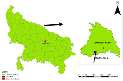
The present study has been carried out in a cluster of villages covering an area of 6,137.57 ha in tehsil Mitauli in south Lakhimpur Kheri district of Uttar Pradesh (U.P.). The district is a part of the Tarai lowlands at the base of the Himalayas, with several rivers and lush green vegetation. On the south of study area lies the districts of Sitapur and Hardoi which were part of large scale sodic land reclamation program which ran from 1993 to 2018. The location of study area is shown in Figure 1. During summer (March–June), the temperature can reach above 40°C and in winters (October–February) it can drop to around 4°C. The nights are very cold during winter and fog is very common in this season. The annual average rainfall in Lakhimpur Kheri is 1,400 mm, which occurs mostly in the monsoon months (July–September). Soil texture varies from sandy loam in the surface to silty clay loam in the sub-surface horizons.
Wheat, rice, maize, mustard, barley, and pulses are the major food crops grown in the area. Recently few farmers have started menthol mint farming in the district, as Terai region is ideal for mint cultivation. Sugar-cane and oilseeds are the chief non-food crops. Sugar-cane is grown and processed in this district, forming the backbone of the local economy. The district has six sugar mills and these sugar mills produces tons of press mud every year which is mostly used up by farmers for enhancing the fertility of soils and/or as an amendment for reclamation of culturable wastelands.
Methodology
Satellite data of 1M spatial resolution from Google Earth, of early and middle rabi season (October–February) has been used for land use mapping and to delineate barren culturable wastelands/sodic areas in particular. The Arc/Info GIS with image processing capabilities software was used for on screen visual image interpretation and mapping of land use changes in the present study.
Google Earth imageries of the study area were geo-referenced using ground control points with the help of Google map for creating different data sets for the years 2003, 2011, 2015 and 2019. The on screen visual interpretation was carried out on 1:10,000 scale and all maps were generated on the same scale to determine spatial changes in land use and barren culturable wastelands/sodic areas from 2003 to 2019. Information about the amount of press mud application in delineated culturable wastelands/sodic soils, crop production and cropping pattern was gathered from the farmers owning these plots in the study area during the ground truth. The relevant soil properties have been extracted from Soil Health Cards of the farmers. The geographical locations of the sugar mills near the study area has been collected using GPS from KumbhiChini Mills, Bajaj Hindustan Sugar Limited GolaGokarrannath, DSCL Sugar Ajbapur and DalmiaChini Mills, Jawaharpur, Awadh Sugar Mill Hargaon.
Results and Discussion
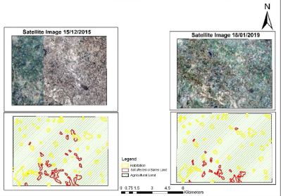
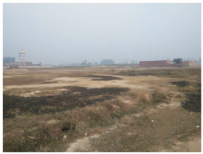
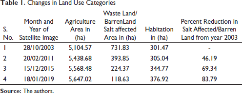
The spatial analysis of satellite images show a continuous reduction in area of culturable waste lands from 2003 to 2019. The result presented in Table 1 show the progressive decrease in culturable wastelands and increase in agricultural area over 16 years. In the year 2011 the agricultural area went up by 46.19%, in 2015 it increased by 69.34% and in 2019 the area under agriculture increased by 83.79% compared to the year 2003. The spatial changes in study area of culturable wasteland have been shown in Figures 2 and 3. Between 2003 and 2019, in 16 years, the culturable wasteland area reduced from 731.83 to 118.63 ha which is about 83.8% reduction while the double cropped agricultural land increased from 5,104.57 to 5,842.42 ha which is about 83.79% (Table 1). In the selected site approximate 16.2% barren sodic lands still remain which are mostly owned by either Gram Samaj or are used for grazing by cattle in the villages. The culturable wastelands are mainly sodic lands which were under sparse cover of a thorny shrubs (mainly Prosopisjuliflora) and wild grasses initially in 2003 which is also supported by satellite imageries. The ground picture of the remaining culturable wastelands taken in the year 2020 also indicate the same (Figure 4). It can also been noticed in Table 1 that area under habitation increased by 25% over a period of 16 years. The spatial analysis of satellite images revealed that only 10.8% increase in habited area is from culturable wastelands while the remaining 14.2% is an encroachment on productive agricultural land.

Changes in Land Use Categories
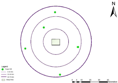
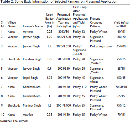
Pressmud is a byproduct which can be used as good organic manure when composted properly. The application of sugarcane press mud is relatively low cost for carbon sequestration besides having advantage of slow release of nutrients and trace element, high water holding capacity and mulching properties. After application of press mud in culturable wastelands, paddy crop was grown by farmers as the first crop. The farmers during ground truth informed that the press mud has been applied to soil after harvesting of rabi crop (i.e. Mustard/Wheat/Sugarcane) in February/March/April. Information thus collected shows application of press mud at varying rates which probably depends on the nearness to the sugar mill and availability of mode of transportation for press mud from sugar mill to the farmers field (Table 2). There are five sugar mills within 75 km of the study area (Figure 5). The composted press mud improves the soil physical properties, organic matter content, nutrient content and enhances the microbial activity (Tisdall & Oades, 1982) The composition of composted press mud obtained from the nearby sugar mill is presented in Table 3. Composted press mud contains essential plant nutrients, such as Nitrogen, phosphorus, Zinc, Copper, Iron and Manganese. Soil organic matter improves granulation, CEC, and enhances the cation uptake capacity upto 90% for Ca, Mg and K. The selected soil properties of the selected farmer’s fields extracted from their Soil Health Cards are given in Table 4. The yield of paddy taken after first application of press mud was far below the average yield of district that is, 60 q/ha but at present the paddy yield varies from 60 to 70 q/ha (Table 2). The variation in the yields can mainly be attributed to lack of proper irrigation facility and grazing of crops by cattle in the areas near to habitation.
The available press mud from adjoining sugar mills has not only helped the farmers in reclaiming their unproductive lands but also created a sink for carbon. Composted press mud is a good source of Soil Organic Carbon and is essential that it remains there. The repeated application of press mud by farmers, as shown in Table 2, is also helping in building up the carbon pool which is evident from Soil Organic Carbon content as high as 0.94% (Table 4).
Some Basic Information of Selected Farmers on Pressmud Application
Composition of Pressmud Compost

Soil Properties of Selected Formers Fields

Conclusion
The easy access to online satellite imageries have helped to identify culturable wastelands and to monitor land use changes over the years in a rural area. The spatial information thus generated can be periodically updated for a larger area for better management of agricultural practices by concerned department. It is well established that the agricultural practices can help increase the rate of soil carbon sequestration. One of the study showed 150% increase in organic carbon after application of pressmud as organic manure (Barry & Skinner, 2002). The farmers have adopted a beneficial practice of regularly adding the pressmud manure to soil, which need to encouraged for mitigating the impact of climatic change and improving the soil health.
Footnotes
Declaration of Conflicting Interests
The authors declared no potential conflicts of interest with respect to the research, authorship and/or publication of this article.
Funding
The authors received no financial support for the research, authorship and/or publication of this article.