




Abstract
The Northeast is now an officially recognised name for a region comprising seven contiguous states, plus the detached state of Sikkim. The article examines how the name evolved in official and scholarly writing, while, in fact, no such region can be justified either by any affinity among its individual parts or by culture, political history, languages, social structure or economic ties. It is argued that such a concept may blur the understanding that each of the region’s distinct parts requires for its problems and aspirations.
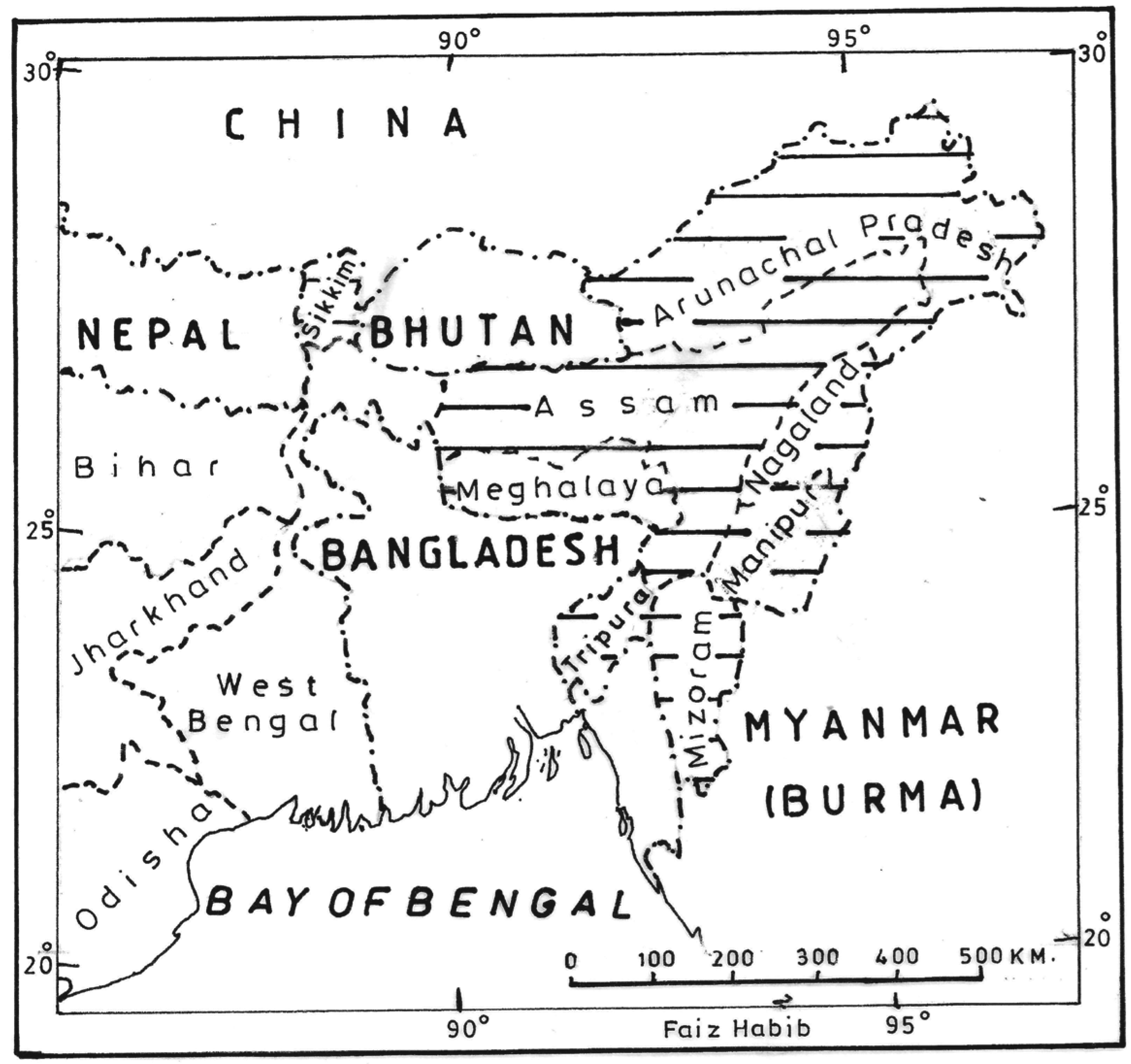
Northeast India, as an administrative region within the Indian Republic, consists of seven states, namely Arunachal Pradesh, Assam, Manipur, Meghalaya, Mizoram, Nagaland and Tripura, and forms a very large contiguous area, of about 255,000 sq. km (see Figure 1). It is land-locked, surrounded by about 4,200 km of porous international borders with Bangladesh, Myanmar, China and Bhutan and connected with the rest of the country by less than 20-km-wide ‘Siliguri neck’. The Ministry for Development of North-Eastern Region (DONER) is currently in place at the Centre and it operates through the North-Eastern Council (NEC) headquartered at Shillong. This NEC was constituted in 1971 by an Act of the Parliament as the nodal agency for economic and social development of the northeastern region. Sikkim was inducted as the eighth member of the NEC in December 2002 by an amendment of the NEC Act, but this state is geographically separated from the rest of the Northeast by the northern districts of West Bengal and the independent Himalayan kingdom of Bhutan. A historical study of the Northeast should therefore take into consideration only the seven continuous states. The region so constituted is known for its geographical, ethnic, cultural and linguistic diversities, and there have been different political formations in different areas of the region in different phases of its history.
Before British colonialisation, the geographical and ethnic sub-regions within the present-day Northeast never experienced a common political authority. In the ancient period, a large part of the region and some neighbouring areas of Bengal were included in Prāgjyotisa-Kāmarūpa which was the common denominator of a regional identity to the rest of the subcontinent. Brahmaputra valley was the heartland of Prāgjyotisa-Kāmarūpa with Kāmākhyā as its most important landmark. 1 In the same period, parts of the region were included from time to time in Pundravardana, Herikela, Vanga, Samatata, etc. 2 In the medieval period, the Ahom kingdom (or the kingdom of Assam) was confined within the Brahmaputra valley. The British annexed Assam in 1826 and made it a division within the Bengal Presidency. The hill areas and three districts from Bengal were added to the Brahmaputra valley districts or ‘Assam proper’ (as some modern historians such as S.K. Bhuyan 3 and H.K. Barpujari 4 prefer to call it) in 1874 when Assam was constituted as a province of British India. British rule thus provided a common political authority for the entire region: Assam was a British province proper; Manipur, Tripura and Cooch Behar were subordinate princely states, and the Khasi estates lay somewhere between British territory and princely states. The British territory was divided into General, Excluded and Partially Excluded Areas, as well as blocs and belts. Before the British annexations, there were as many as six kingdoms, many chieftaincies and innumerable autonomous tribal formations in the Northeast, with no notion of a common political framework. 5
India: States of the Northeast
The British, who occupied or subjugated the region in bits and pieces, referred to this part of the subcontinent as ‘North-East Frontier of Bengal’. The colonial intervention began in 1818 when three Thana areas of the Rangpur district of Bengal, namely Goalpara, Dhubri and Kairaibari, were separated from the parent district and made into the Civil Commissionership of northeast Rangpur (later on Goalpara district) to tackle the challenge of intermittent Garo raids, with David Scott, then Joint Magistrate of Rangpur, appointed as its first Civil Commissioner. On the eve of the first Anglo-Burmese War (1824–26), a post of Agent to the Governor General for North-East Frontier was created to look after the entire region from Bhutan to Burma, with David Scott again as the first Agent. 6 The British looked upon the region as a frontier of Bengal and formulated their policies accordingly. The North-East Frontier eventually shifted to the present-day Arunachal Pradesh (erstwhile North-East Frontier Agency or NEFA). Alexander Mackenzie submitted to the Government his Memorandum on the North-East Frontier of Bengal in 1869 and his book History of the Relations of the Government with the Hill Tribes on the North-East Frontier of Bengal was published by the Bengal Government in 1884. Some writers also called it the ‘Eastern Frontier’; for example, R.B. Pemberton in his Report on the Eastern Frontier of British India (Calcutta,1835) and A.C. Banerjee in Eastern Frontier of British India (Calcutta, 1943), the phrase ‘North-East Frontier’ seems to have been more commonly employed. S.N. Bhattacharya’s The Mughal North-East Frontier Policy was published in 1942, and as late as 1970 H.K. Barpujari titled his multivolume work on tribal policies of the British as Problem of Hill Tribes: North-East Frontier (Vol. I, Gauhati, 1970). One British officer-scholar of ancient history, H.E. Stapleton was possibly the first writer to use the designation ‘North-Eastern India’. His article entitled ‘Contributions to the History and Ethnology of North-Eastern India’, published in Journal of the Asiatic Society of Bengal (Vol. VI, pp. 141–66) in 1910, dealt exactly with what used to be identified in ancient times as Prāgjyotisa-Kāmarūpa. On the other hand, the Indologist Radhagovinda Basak’s History of North-Eastern India (Calcutta, 1934), actually covered northern and eastern India (Kānyakubja to Samatata) with only a casual treatment of Kāmarūpa under Bhāskaravarman as an ally of Harshavardhana. However, a Khasi civil servant and intellectual, David Roy published his The Frontiers of North-East India (Shillong, 1947) in which northeast India meant the then Assam, NEFA (now Arunachal), Manipur and Tripura, or what the region is today.
The regional identity of the present-day Northeast seems to have emerged only during the last fifty years. For many years after independence, the Planning Commission and other central departments and agencies in their documents referred to this region as ‘Assam and the neighbouring states’, ‘Assam and the Hill Areas’ etc. For planning and development, it was a part of the Eastern Region, while for departments of Post & Telegraph, Telecom, Income Tax, etc., it was mostly Assam Circle headquartered in Shillong, and for the Indian Railways it was the North-East Frontier Railway headquartered at Maligaon (Guwahati). The quests for identity began in the 1960s when Assam was in turmoil on the language issue, followed by hill state movements spearheaded first by the Eastern India Tribal Union and then by All Party Hill Leaders Conference as well as popular reaction against economic backwardness and the presumed indifference of the Central Government. Insurgency and militancy followed thereafter. The veteran freedom fighter and revolutionary-turned-Gandhian, Pannalal Dasgupta organised a seminar in Calcutta in 1964 attended by scholars and political leaders from the Northeast, on the problems of development of the region. The volume of proceedings of the seminar was published under the title A Common Perspective for North-East India (Calcutta, 1966). This was perhaps a turning point in the region’s quest for a common identity. In 1970, the Khasi-Jaintia and Garo Hills districts were constituted into a Sub-State (Meghalaya) within Assam. In 1971, the two Union Territories of Manipur and Tripura became States, and the Mizo Hills district and the erstwhile NEFA became Union Territories, while Meghalaya was upgraded to a full-fledged State in 1972. The North-Eastern Hill University was established in 1973, and this was followed by the creation of North-Eastern Circles and Divisions of the central organisations and agencies and establishments of regional institutes and authorities for the Northeast. The Northeast became a region (separated from the Eastern Region), and finally, there was established a separate ministry at the Centre (DONER) for the development of the region. Academics have also played some role in endowing the region with a common identity. North-east India Council for Social Science Research was founded in 1973 and North East India History Association in 1979. This has been followed by many discipline-level northeast regional societies and associations, such as for Political Science, Education, Anthropology, Geography and others. On demand of the academia, the ICSSR, ICHR, ICCR, UGC and NCERT established their Regional Centres in the Northeast. Among scholarly books, N.K. Barooah’s David Scott in North-East India came out in 1970 and S.K. Chaube’s Hill Politics in Northeast India in 1974. By now Northeast is in the title of numerous of books and articles in almost all disciplines.
Northeast is undoubtedly a region today for the purpose of development initiatives, but the diversity within the region is pronounced and the single common factor is the economic and infrastructural backwardness of the seven northeastern states as compared to other regions of the country. Studying the social processes in the region may require a region-specific framework, which is yet to be developed. This framework also should probe whether—and if so, in what way the Northeast is in reality a region. A region is more than a physically defined territory when it has common characteristics—historical, political, administrative, economic, linguistic, ethnic or cultural—that would make it distinguishable from the surrounding territories and endow it a common identity. 7 In case of northeast India, it is geographically fringed on three sides and intersected in the middle by mountain ranges. 8 Environmentally, it is one of the major hotspots of biodiversity in the world. 9 Historically, several distinct culture zones emerged in the region on the basis various ethnic and linguistic groups or distinct polities, such as Brahmaputra valley, Barak (-Surma) valley-Tripura plains, Manipur valley and the hills division. 10
The valleys of the Brahmaputra and the Barak are the two major low-lying geographical segments, which are connected with the Indo-Gangetic plains through Bengal. The Manipur valley is encircled by hills, except the narrow trans-Barak basin that connects it to the Barak valley. The Brahmaputra valley is also encircled by the continuous hill chain of the Garo, Khasi-Jaintia, Dimasa, Karbi, Naga, Arunachal and Bhutan hills. The Khasi
The peoples in the region consist of the Indo-Aryan and Indo-Mongoloid ethnic elements. In fact, the Indo-Aryans and the Indo-Mongoloids seem to have been living in this northeastern sentinel of Indian subcontinent since prehistoric times. The Indo-Aryan settlements extended from the Indian heartland to the valleys of Brahmaputra and Barak-Surma, and even to the Manipur valley to a lesser extent, in their eastward advance to the farthest limits of the ploughable fertile plains lands, while the Indo-Mongoloids are believed to have come from various parts of Southeast Asia through the Tibetan-Chinese and the Burmese routes which were also used for trade between India, China and Southeast Asia. The hill areas were entirely under occupation of the Indo-Mongoloids, but in the plains the Indo-Mongoloids and the Indo-Aryans lived side by side and contributed to each other’s cultural life, thereby initiating in a process of adjustments and assimilation. The peoples of the hills and the plains also interacted in the foothill areas through barter trade which played a critical role in cultural and material development in both the areas. No wonder, the civilisation of the Indo-Gangetic plains took deep roots in the plains areas of the Northeast which also developed contacts with the Chinese and Burmese civilisations. 13
In early Indian history, the regional concept of Prāgjyotisa-Kāmarūpa included the bulk of the present-day Northeast as well as parts of North Bengal and some adjoining areas of Bangladesh. The Brahmaputra valley, which formed the heartland of Prāgjyotisa-Kāmarūpa, was ruled by the Varman, Śālastambha and the Pāla dynasties till about twelfth century
‘Unity in Diversity’ no doubt looms large in the contemporary scenario, but the diversity is apparent in geographic structure, as well as in ethnic, linguistic and religio-cultural compositions. Assam, Manipur and Tripura consist of hills and plains, while Arunachal Pradesh, Meghalaya, Nagaland and Mizoram are hill states predominantly inhabited by hill tribes. Assam itself is multi-ethnic, multi-lingual and multi-cultural, while in Manipur and Tripura the hill areas are inhabited by different tribes. The non-indigenous/‘others’, including persons from different parts of the country, have a significant presence in almost all the states. The ethnic and linguistic tensions have affected social harmony several times even in the recent past, and the boundary disputes between some of the states are yet to be resolved. Since the first general elections in 1952, all the states have been ruled mostly by the national political parties but the regional parties also sometimes formed governments in some of the states; the different states voting for different parties at different times without any pattern emerging in their electoral behaviour.
It is, perhaps, time that we should look behind any generality ascribed to the Northeast and treat its distinct parts as unique units on their own. This may be more respectful of the region’s constituent parts, and contribute to a better understanding of the needs of each ‘sub-region’.