



Abstract
The Dutch concept of ‘bicycle highways’ is increasingly being adopted by urban planners owing to rising environmental and health consciousness, and the growing popularity of electric bicycles. Bicycle highways differ from other types of cycling infrastructure in that they avoid intersections with motorised traffic, and are wide enough to allow for safe overtaking, thereby increasing cycling speeds. While many studies investigate the feasibility of constructing bicycle highways, few explore their effect on users’ travel preferences. In this context, our study aims to assess the potential impact of bicycle highways on commuter mode choice. We built a discrete choice model based on individual commute data from a national household travel survey, Mobilität in Deutschland 2008. The model was estimated in a logit modelling framework using Biogeme. We estimated multinomial logit and nested logit models and found nested logit to be more appropriate. The model estimates were then applied to forecast mode shares in scenarios with the pilot bicycle highway proposed in the Munich region. The variation in mode shares across scenarios with increasing average cycling speeds was analysed in areas with varying proximity to the infrastructure. The results suggest that bicycle highways reduce motorised travel and increase cycling. The effect is stronger as proximity to the corridor increases. The analysis helps to quantify the potential impact of bicycle highways on commuter mode choice even without considering further benefits beyond travel time reductions, such as increased safety, convenience, comfort, and reduced risks due to fewer interactions with motorised traffic.
Introduction
Cycling is perhaps the most environmentally sustainable of all modes of transport save walking. Its impact on the environment is negligible and it has relatively minimal space, energy, and infrastructure requirements (Heinen et al., 2010; Kuhnimhof et al., 2010). However, it is slower, calls for greater physical effort, and directly exposes users to climatic conditions. Nevertheless, growing environmental and health consciousness draws more and more people to cycle regularly.
With growing levels of congestion and pollution, cities worldwide are increasingly investing in policies to encourage cycling (Heinen et al., 2010). Bicycle highways are one of many such efforts envisioned to facilitate cycling for medium- to long-distance commutes. They differ from other types of cycling infrastructure in that they avoid intersections with motorised traffic, and are wide enough to allow for safe overtaking, thereby increasing cycling speeds (European Cyclists’ Federation, 2014). The separation from other traffic eliminates the need for cyclists to stop and accelerate often, facilitating longer distances for the same amount of energy expenditure. The concept was founded in the Netherlands and has spread to many European countries (Tscharnke, 2015).
Recognising the potential of bicycle highways, many regions in Germany are considering the implementation of such networks – the Ruhr region is constructing its pilot, routes are being identified in Munich, and many other cities are drafting plans (O’Sullivan, 2016). To quantify this potential, we studied the probable impact of bicycle highways on commuter mode shares in the Munich metropolitan region.
This article presents the results of our study quantifying the potential impact of bicycle highways proposed in the Munich metropolitan region on the region’s commuter mode share. We employ a discrete choice model based on commute data from a national household travel survey to predict mode shares in hypothetical scenarios with bicycle highways. The article is structured as follows: first, bicycle highways are introduced, followed by a review of relevant previous research; then our commuter mode choice model and the results of the scenario analysis are presented.
Bicycle highways
Bicycle highways are ‘high-standard bicycle paths reserved for cyclists for fast and direct commuting over long distance’ (European Cyclists’ Federation, 2014). They were pioneered in the Netherlands as ‘Snelfietsroutes’ in 2003 (European Cyclists’ Federation, n.d.[2014]). Soon, the concept was adopted in many north European regions – Copenhagen (Supercykelstier), London (Cycle Superhighways), Germany (Radschnellwege), Belgium (Fietsostrade), Strasbourg (Vélostras), Sweden (Supercykelväg), Norway (Super-Sykkelveier), and Switzerland (Velobahnen). Some characteristics of bicycle highways listed by the European Cyclists’ Federation (2014) require that bicycle highways:
Be at least 5 km long; Have a minimum width of 3 m, if one-directional, and 4 m, if bi-directional; Be separated from motorised traffic and pedestrians; Avoid steep climbs and afford mild gradients; Avoid frequent stops to enable high average speeds; and Receive regular maintenance, e.g. winter service, lighting, service stations, etc.
Although characteristics vary from region to region, the central idea is to provide direct, fast, and safe bicycle trips, thereby encouraging commuters to ride to work instead of driving.
Bicycle highways in the Munich metropolitan region
The planning association of the Greater Munich region, Planungsverband Äußerer Wirtschaftsraum München (2015), studied commute patterns in the region and identified 14 potential bicycle highway corridors with design speeds of up to 30 km/h. The routes are suggested to be 4 m wide and grade separated (Walter, 2015). No helmet or minimum speed regulations are intended.
In a study commissioned by the City of Munich, experts shortlisted 6 out of the 14 routes for further consideration, and recommended a 17 km pilot route from the city boundary to adjacent municipalities to the north (Schwägerl, 2016). Figure 1 depicts the proposed and shortlisted corridors, and the pilot corridor.

Bicycle highway corridors proposed in the Munich region. Source: Reproduced with permission from Planungsverband Äußerer Wirtschaftsraum München (2015b: 51) and OpenStreetMap contributors (2017).
Although Munich has intensively explored feasible routes for the bicycle highways, their realisation has been delayed due to the complexity of the project and the unclear division of responsibilities in the state of Bavaria (Mühlfenzl, 2016). The region’s planners assert that without the active participation of the state, land acquirement issues could further delay the bicycle highways (Mühlfenzl, 2016). In this context, this research is intended to inform decision makers of the potential impact of introducing bicycle highways on commuter mode share in the region.
State of the art
Several studies have explored the impacts of bicycle infrastructure. Song et al. (2017) investigated modal shifts from private car to walking and cycling brought about by new and improved walking and cycling infrastructure in the UK. Krizek et al. (2009) analysed the effect of bicycle facilities on commuter mode share over time in the Minneapolis–St Paul, Minnesota area. Dill et al. (2014) studied the impact of installing bicycle boulevards – ‘low-volume streets, often residential, that use traffic calming, diversion, signage, and intersection treatments to reduce the speed and volume of motor vehicles and create a better environment for people on bicycles’ – in Portland, Oregon, through a longitudinal panel survey of adults with one or more children aged between five and 17. Goeverden et al. (2015) presented ex-post evaluation results of the implementation of various dedicated and shared space bicycle facilities in Denmark and the Netherlands. Most of the evaluations were based on cycling counts and cyclist surveys. Zahabi et al. (2016) explored the potential impact of cycling infrastructure on bicycle commuting and thereby greenhouse gas emissions in Montreal, Canada. Heinen et al. (2017) studied the travel behaviour of commuters working in Cambridge, UK over four years to assess patterns of change in travel behaviour on exposure to a dedicated busway with walking and cycling paths. Aziz et al. (2018) developed an agent-based model to assess the impacts of widening sidewalks and building more bicycle lanes on mode shares in New York. Most of the studies found a positive influence of additional bicycle infrastructure on increasing bicycling. However, the extent of the influence appears to vary depending on the study parameters and design.
Some studies also investigated bicycle highways and similar infrastructure. Knoflacher and Brezina (2007) estimated the extent of use of a potential bicycle highway in Vienna by computing the number of potential bicycle trips on the new infrastructure based on a small-scale survey and census data. Layton et al. (2007) developed a bicycle highway proposal for the United States of America through a cost–benefit study. Pachuta (2010) surveyed bicyclists along a bicycle–pedestrian corridor that runs through Minneapolis, Minnesota and examined the types of trips made on the path, the deterrents to using the path more frequently, and the distances they would be willing to travel to use the path. The study contests that if off-street bicycle facilities, like most on-street facilities, are developed with high connectivity and proximity to retail, they would have a similar ability to increase ridership. Skov-Petersen et al. (2017) investigated the effects of upgrading two major bicycle corridors to bicycle highways in Copenhagen on bicycle volumes, mode shares and cyclists’ behaviour, perceptions, and attitudes. They analysed data from automatic counting stations, and surveyed users before, one and two years after the infrastructure upgrade. Bicycle volumes were observed to increase, mainly due to relocation of bicyclists from other routes; however, 4–6% of users switched from other modes to bicycle. Further, cyclists expressed a significantly better user experience and higher satisfaction with the infrastructure. The authors highlight the importance of evaluating induced bicycle trips, and user experience and satisfaction in addition to bicycle volumes while evaluating the impacts of bicycle highways. Kristjansdottir and Sjoo (2017) investigated the design standards for bicycle highways in various European countries and suggested design standards for those in Sweden. They further carried out a case study implementing the proposed standards to a bicycle route between Gothenburg, Partille and Lerum, and estimated the time gain of the new, more direct infrastructure compared to the current facility.
While the impacts of conventional bicycle infrastructure have been well researched, the same does not apply to bicycle highways. Investigations on bicycle highways are either feasibility/cost–benefit studies or ex-post evaluations which are not easily transferrable to other regions. Modelling the potential impacts of proposed bicycle highways through a straightforward travel demand model aids decision making. In this context, we built a commuter mode choice model based on daily commute data from a national household travel survey to analyse the potential of bicycle highways in bringing about travel behaviour changes measured in the form of modal shifts.
Review of mode choice modelling
Individual preferences have traditionally been described in a discrete choice framework where individuals’ travel choices are modelled econometrically using the principle of utility maximisation (Ben-Akiva and Lerman, 1985). Under this framework, individuals are modelled to choose the alternative with the highest utility when confronted with a set of alternatives. To analyse such models, several model structures have been developed – logit, probit, etc. Due to computational convenience, logit models – and among them, the ‘multinomial logit’ and ‘nested logit’ structures – are the most widely used (Munizaga and Ortúzar, 1999). While multinomial logit models involve a simplified structure where all choice alternatives are mutually independent, nested logit models allow for correlation between alternatives by grouping them into hierarchical nests.
Mode choice for commute trips has been extensively researched. We reviewed other similar commute mode choice studies – Noland and Kunreuther (1995), Wardman et al. (1997), Rodrı́guez and Joo (2004), Wardman et al. (2007), and Parkin et al. (2008) – for an overview on the modal attributes and model structure. Although nested logit is conceptually superior, multinomial logit models are still widely used owing to their computational simplicity. Consequently, we estimated both multinomial logit and nested logit models and compared their predictive capacities.
Commuter mode choice model
We built a mode choice model based on commuter trip data available from the most recent national household travel survey, Mobilität in Deutschland (MiD) 2008. MiD is a repeated, cross-sectional survey conducted sporadically (once every 6–10 years) over an entire year to observe daily travel behaviour trends of individuals and households (infas Institut für angewandte Sozialwissenschaft GmbH, n.d.). MiD2008 records mobility-related and socio-demographic information of over 25,000 households and can be accessed from Bundesministerium für Verkehr und digitale Infrastruktur (n.d.[2009]).
Model specification
Within the discrete choice modelling framework, specifying a model involves identifying the choice set, selecting explanatory variables, and deciding on the model structure (Ortúzar and Willumsen, 2011). Considering the purpose of the model and the standard mobility patterns in Germany, we chose the following model alternatives – Auto (automobile drivers and passengers), Bicycle, Transit, and Walk.
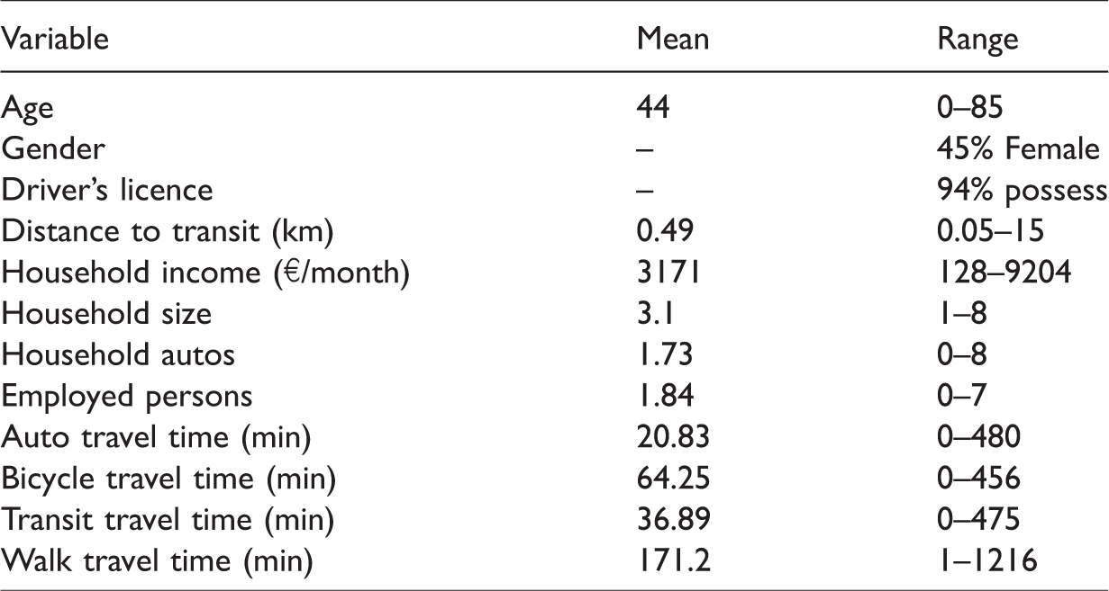
Based on the review of previous research and the availability of information in MiD2008, the following variables were considered to model commuter mode choice – age, gender, possession of driver’s licence, distance from home to the nearest transit stop, household income, household size, number of household autos, number of employed persons in the household, and travel time from home to work. Table 1 gives an overview of these variables.
Overview of explanatory variables.
MiD2008 data report travel times by the chosen mode, whereas the model requires travel times for all alternatives. To circumvent this, we imputed commute times for modes not chosen using commute distances and average modal speeds of the reported commutes (auto – 38.6 km/h, bicycle – 13.7 km/h, transit – 20.9 km/h, walk – 4.8 km/h). We could not consider travel cost, a widely used mode choice attribute as the survey did not record costs or micro-locations of trip origins and destinations. Nevertheless, as the introduction of bicycle highways does not change the travel costs of bicycling, this limitation does not restrict the current analysis.
As is most appropriate for mode choice studies, we modelled the mode choice behaviour of the commuters in our dataset by applying a logit modelling framework.
An important and widely discussed aspect of the multinomial logit model is the ‘Independence from Irrelevant Alternatives’ property which states that when choice probabilities of two alternatives are non-zero, their ratio is independent of any other alternative in the choice set (Ortúzar and Willumsen, 2011: 234). By virtue of this property, the addition or removal of an alternative to or from the choice set has the same effect on every other alternative in the choice set. But in reality, alternatives are not completely independent. This inability of multinomial logit models to capture correlations between alternatives is addressed in the nested logit modelling framework.
To solve the problem of having correlated alternatives, nested logit models group alternatives into hierarchical nests so that similar alternatives are grouped together. We estimated two nesting structures in addition to the multinomial logit model to find the best model fit. Figure 2 depicts the structures of the three models – multinomial logit, nested logit 1, and nested logit 2.

Model structures.
Nested logit 1 assumes similarities between the motorised modes auto and transit and the non-motorised modes bicycle and walk, and groups them accordingly. Nested logit 2 considers bicycle and walk to be as dissimilar as bicycle and the motorised modes, which is perhaps more realistic for European cities.
Model estimation
Using Biogeme (Bierlaire, 2016), we performed maximum log-likelihood estimations for all three model structures. To ensure mutual independence of variables, we first analysed correlations between all variable pairs.
As seen in Figure 3, household income, household size, number of household autos, and number of employed persons demonstrate larger correlations than other variables. Hence, only one among the four, number of household autos, was included in the models as it resulted in a better fit. A comparison of predictions of the three models, estimated with a minimum 95% level of confidence, can be seen in Table 2.

Variable correlations.
Comparison of mode share predictions.
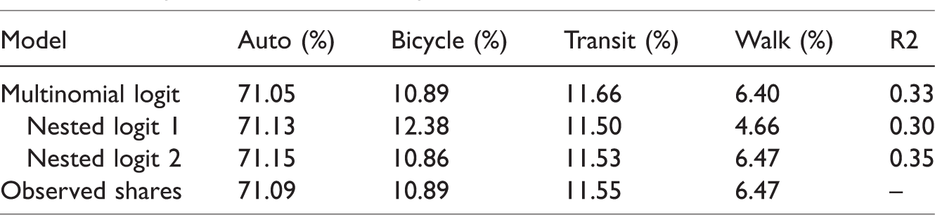
Although the shares predicted by the multinomial logit model are the closest to the observed shares, the nested structures are known to better represent cross-elasticities between modes and this superiority is evident from the
Model estimates.
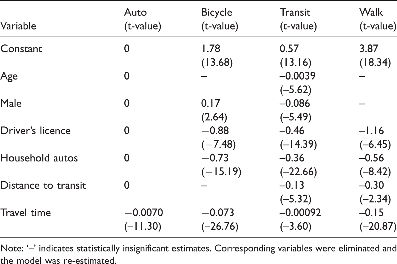
Note: ‘–’ indicates statistically insignificant estimates. Corresponding variables were eliminated and the model was re-estimated.
As utility is a dimensionless index meant for comparing the attractiveness of alternatives on a common scale, one of the alternatives is set as the base alternative against which the other alternatives are compared. We considered auto as the base alternative, therefore the coefficients of all individual-specific variables are set to zero while computing auto utility.
Mode-specific constants: These constants capture the effect of unobserved variables and measurement errors. Auto has a constant value of
Age: The negative estimate for transit indicates that as individuals get older, they are less likely to take transit to work than they are to drive. The variable was not statistically significant for bicycle and walk, and therefore was excluded for those modes from the estimate.
Male: The positive estimate for bicycle indicates that males are more likely to cycle to work than females, a result that has been observed in many studies (Halldórsdóttir et al., 2011; Rodrı́guez and Joo, 2004). The estimation further indicates that males are less likely to take transit to work than females, perhaps because they cycle and drive more. The estimate for walk was not statistically significant, and hence excluded from the estimation.
Driver’s licence: The estimates indicate that individuals with driver’s licences are less likely to walk, ride a bicycle, or take transit, in that order, than they are to drive.
Number of household autos: All the estimates are negative, indicating that as the number of autos in a household increases, the likeliness of an individual from that household to commute by a mode other than auto decreases. This effect appears to be the strongest on bicycle, followed by walk and then transit.
Distance to transit: When transit accessibility decreases, the probability of using transit decreases. The same is reflected by the estimate for transit. However, the effect on walk appears stronger. As transit accessibility tends to increase with neighbourhood density, residents of less dense areas can be understood to be more likely to drive to work than they are to walk. The estimate for bicycle was not statistically significant, and hence excluded from the estimation.
Travel time: The travel time parameter estimates of all four modes are consistently negative. This is expected as when travel times increase, utility decreases. Further, the estimate for travel time by walk is the most negative, followed by bicycle and auto; implying that for an increase in travel time to work, walking becomes the least attractive mode, and cycling the next least attractive and driving thereafter. Transit travel time is estimated to have the least negative parameter indicating that transit becomes the least unattractive of all modes for an increase in travel time to work. This could be because transit riders are accepting of longer travel times, and hence, an increase in travel time is not critical. Perhaps, commuters do not ride transit because it is faster but because it is more convenient, which is especially true in Germany due to a limited parking supply. Furthermore, individuals can engage in other activities like replying to e-mails, etc. while on their commute by transit which perhaps makes transit more attractive for long commutes. Moreover, due to data limitations, the model does not consider variables like parking costs, waiting time, number of transfers, and combined access and egress time separately, which perhaps explain the choice of transit better than the overall travel time.
Bicycle highway scenario analysis
We analysed the potential impact of the pilot bicycle highway proposed for the Munich region on commuter mode shares. Due to the lack of detailed route plans for the corridors other than the pilot, we limited our analysis to the pilot corridor. The 17 km bicycle highway is proposed to run between the city centre and the northern suburbs.
Dataset and scenarios
In order to set up the dataset for the analysis, we used the geographical zone system, synthetic population, and MATSim (an agent-based traffic assignment model (Horni et al., 2016)) network being developed for the metropolitan region of Munich as part of a regional land-use and transport model (Moeckel and Nagel, 2016). We introduced the bicycle highway corridor into the MATSim network, imposed the network on to the zone system, and selected the 474 zones that lie within a 2 km radius around the bicycle highway for the analysis. A detailed description on the creation of the zone system is available in Molloy and Moeckel (2017).
We classified the 474 zones into three study areas with varying proximity to the bicycle highway, illustrated in Figure 4, to analyse the effect of proximity on the variation in travel behaviour. The study areas include:

Scenario study areas. Source: ADFC München e.V. (2014) and OpenStreetMap contributors (2017).
Zones within a 2 km radius of the pilot bicycle highway (474 zones)
Zones within a 1 km radius of the pilot bicycle highway (279 zones)
Zones containing the pilot bicycle highway (44 zones)
The individuals living and working within these 474 zones were then extracted from the synthetic population which was generated based on census data. Through this exercise, we set up a dataset of 37,417 individuals with home-to-work trips within a 2 km radius of the bicycle highway.
All variables considered in the commuter mode choice model were available from the synthetic population except travel times. Travel times were obtained for each mode by performing an iterative dynamic traffic assignment in MATSim.
To test hypothetical scenarios with the pilot bicycle highway, we created six scenarios with increasing bicycle speeds on the bicycle highway. The process of getting travel times was repeated for each scenario, without changing any other variable. The simulated scenarios include:
Base case: Network as it is today. Scenario 100: Network with bicycle highway, with cycling speeds on the bicycle highway equal to that of regular streets. Scenarios 120, 140, 160, 180, 200: Network with bicycle highway, with a 20, 40, 60, 80, and 100% increase in bicycle speeds on the bicycle highway, respectively, assuming higher speeds due to a lack of intersections with other traffic and an escalation of electric bicycle use. Each step increases the bicycle speed on the bicycle highway by 2.8 km/h.
Figure 5 presents the resulting average cycling speeds of all cycle commutes in the study area, not just those on the bicycle highway.
Variation of average bicycle speed for all bicycle trips across scenarios.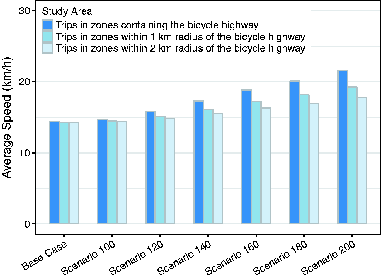
Results of the analysis
The dataset for commutes between zones within a 2 km radius of the bicycle highway comprised 37,417 trips, commutes in zones within a 1 km radius of the bicycle highway had 14,556, and the zones containing the bicycle highway included 484 commutes. We applied the commuter mode choice model estimates (those from Nested logit 2 shown in Table 3) on each of these datasets and predicted individual choice probabilities. The mode shares thus predicted are illustrated in Figure 6.
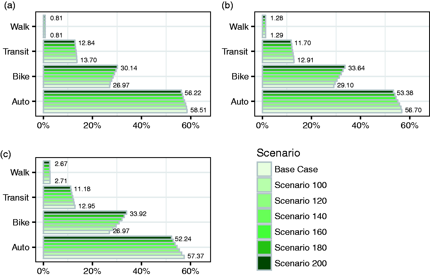
Mode shares predicted across scenarios. (a) Commute shares within 2 km of bicycle highway, (b) commute shares within 1 km of bicycle highway, and (c) commute shares in zones on bicycle highway.
The model predicts higher mode shares for bicycle and transit than the region’s average seen in Table 2. This is attributable to the existing cycling infrastructure in the study area which is better than the region’s average, and the presence of a subway line running almost parallel to the bicycle highway corridor. The resulting walk shares are difficult to explain: the zone system is perhaps too coarse to model walk trips efficiently as most walk trips are short and could be lost when they are intra-zonal.
Furthermore, the results show an increasing sensitivity of bicycle mode share to adding the bicycle highway and increasing cycling speed on the bicycle highway. Bicycle mode shares increase between the base case and Scenario 100, indicating an increase in cycling by merely providing the additional bicycle route. This is attributable to the increase in bicycle utility due to a more direct bicycle route provided by the bicycle highway. The modal shift is seen most sharply in the commutes between zones containing the bicycle highway, followed by those within a 1 and 2 km radii, respectively, highlighting the importance of accessibility to the facility in impacting bicycle shares. Across scenarios, as cycling speeds increase, bicycle mode shares rise with a corresponding reduction in auto shares; a milder effect is seen on transit shares and a much milder effect on walk shares. The predicted modal shifts follow cross-elasticities governed by the model structure. Further, the variation in the predicted mode shares becomes stronger with an increase in proximity to the bicycle highway.
The results show a modest shift in trips to bicycle due to the implementation of the bicycle highway, indicating that bicycle highways alone would not be able to drive major changes. Best practice examples suggest the requirement of strong governmental support to prioritise cycling over motorised modes to bring about major changes (Hull and O’Holleran, 2014; Song et al., 2017). However, it is important to note that the model was estimated under limited data availability conditions and applied to scenarios assuming hypothetical bicycle speeds, and that the forecasts are only as good as the model’s behavioural assumptions, meaning any changes in personal preferences beyond 2008 and those brought about by bicycle highways would not be captured. Nevertheless, we believe the study’s estimates are conservative assuming that people are more health and environment conscious today than in 2008 and considering that only travel time benefits introduced by the bicycle highway are considered while such dedicated facilities are likely to affect people’s perceptions of safety and convenience.
The research could be extended in the future by updating the estimates to base them on more recent travel survey datasets with micro-location information and extending the analysis to the entire bicycle highway network proposed for the region – both of which could not be attempted here due to lack of data availability.
Conclusion
This study quantifies the potential influence of bicycle highways on promoting cycling and reducing travel by motorised modes with the help of a mode choice model. The model predicts modest mode shifts from motorised modes to cycling; however, it also shows a reduction in auto travel, an important outcome to reduce greenhouse gas emissions, and high concentrations of particulate matter in urban areas. Further, the impact of bicycle highways on bringing about mode shifts is shown to diminish with decreasing proximity to the infrastructure, highlighting the importance of the density of such a network to attract major shifts from motorised modes. Although bicycle highways cannot be the only policy to reduce auto use, they may become a crucial part of the strategy to reduce congestion and environmental impacts of the transport system.
The study, however, faces data availability limitations. With information on commute origins and destinations, modal decisions can be better modelled by including travel costs, and transit access and egress times. This could not be included in the current model due to the unavailability of micro-location data. Further, with a finer zone system, non-motorised travel could be better modelled. But this would reflect on computing time when considering a large-scale model. It is important to note that the model does not consider the impacts of bicycle highways on attributes like perceptions of increased safety, comfort, convenience, and reduced risks, which would further improve cycling utility. This limitation of the model indicates that the prediction is on the conservative side. The results can thus provide further impetus to accelerate the realisation of bicycle highways in the Munich region.
Footnotes
Declaration of conflicting interests
The author(s) declared no potential conflicts of interest with respect to the research, authorship, and/or publication of this article.
Funding
The author(s) disclosed receipt of the following financial support for the research, authorship, and/or publication of this article: The research was completed with the support of the Technical University of Munich – Institute for Advanced Study, funded by the German Excellence Initiative and the European Union Seventh Framework Programme under grant agreement number 291763.