



Abstract
Artificial light has transformed urban life, enhancing visibility, aesthetics, and increasing safety in public areas. However, too much unwanted artificial light leads to light pollution, which has a negative effect on public health and urban ecosystems, as well as on the aesthetic and cultural meanings of the night sky. Some of the factors interfering with the estimation of light pollution in cities are urban features, such as the presence of trees, road dimensions, and the physical characteristics of buildings. In this study, we proposed a simplified model for unwanted upward light coming from street luminaires based on a building height model and the publicly accessible Google Street View images. We simulated and analyzed the obstruction effects of different street features on the light pollution caused by the street lighting system in Cambridge, Massachusetts. By providing quantitative information about the connections between the streetscape features and the amount of unwanted upward artificial light, this study provides reference values to inform policies aimed at curbing light pollution.
Introduction
Artificial light has transformed urban life, enhancing visibility, aesthetics, and increasing safety in public areas. In fact, artificial lighting has long been seen as the indicator of modernity and safety in cities (Lawson et al., 2018; Lyytimäki et al., 2012). Artificial light rebalances the social, cultural, and economic aspects of human life for centuries tied to the diurnal and seasonal cycles of light and darkness (Edensor, 2017). And as early as the 17th century, European monarchs invested in manipulating the darkness through public and festive illuminated events that “nocturnalize” social life (Edensor, 2015).
Electrification brought the impact of artificial light to another level. The spatial and temporal effects of street lights include connecting communities, creating lively downtown areas, increasing how long citizens can safely enjoy public spaces, and boosting commercial areas. Artificial light has created territories within cities, areas charged with meanings of safety and danger, excitement and depression without any physical demarcation but the presence of light (Duarte, 2018). Bille and Sørensen (2007) proposed the term “anthropology of luminosity” for the study of the social and cultural aspects of light, i.e. light not just as a medium, but as an active agent of social transformations.
However, the “electrical sublime” that initially surprised urbanites would later also show possibilities of breakdown and dysfunction (Nye, 2010). Artificial lights also have negative effects on human health (Falchi et al., 2011; Stevens, 2009), aesthetic amenities (Mizon, 2002; RCEP, 2009), and on urban ecosystems (Davies et al., 2013; Gaston et al., 2014; Kyba et al., 2011; Longcore and Rich, 2004). Those negative effects on aesthetic amenities, species, and ecosystems are influenced by the spectral compositions of artificial lights (Aubé et al., 2013; Longcore et al., 2018). The inefficient lighting system that produces unwanted light also increases energy consumption and carbon emissions (Elvidge et al., 1997; Kumar et al., 2016). Additionally, artificial lights are likely to influence the nitrogen dynamics, which would possibly increase levels of air pollution (Stark et al., 2011). Thus, although an essential feature of modern urban life, artificial light in excess (or light pollution) has negative impacts in cities.
There is a rising concern with the problems generated by unwanted nocturnal light—light pollution has been growing at an annual rate of 6%, causing night sky degradation (Rodríguez et al., 2015). Artificial light causes the sky in urban areas to be six times brighter than the sky in rural locations that are only 9–20 kilometers away (Davies et al., 2013). Currently, more than 80% of the world’s population live in light-polluted areas, and this number reaches 99% in the United States and Europe (Falchi et al., 2016). There is an increasing interest in making lighting systems more energy-efficient, while simultaneously, minimizing light pollution. The light trespass of street lighting in the urban area is one of the major sources of light pollution in cities (Du and Zhang, 2015; Hiscocks and Guðmundsson, 2010). In Berlin, Germany, for instance, Kuechly et al. (2012) surveyed the spatial distribution of light pollution using 1 meter resolution aerial imagery collected at night, and they found that street lighting is the dominant source of light pollution. In the United States alone, there are 40 million streetlights consuming large amounts of energy annually, which is partially used to generate unwanted light, causing light pollution in cities (Kumar et al., 2016). Therefore, quantitatively assessing the upward unwanted light coming from the street lighting system can contribute to devising ways to attenuate light pollution in cities and save energy.
The remote sensing of nightlights has been used for decades to investigate the spatial pattern of economic activities and demographic distributions (Elvidge et al., 1999; Imhoff et al., 1997). The coarse resolution of nightlight data from DMSP/OLS (Meteorological Satellite Program/Operational Linescan System) is globally available, and it has been used to detect spatial variations of human socioeconomic activities associated with city lights at regional scales (e.g. Chalkias et al., 2006). Falchi et al. (2016) generated a global artificial night sky brightness database based on DMSP/OLS data. Estrada-García et al. (2016) used VIIRS images with a spatial resolution of 700 meters and a multivariable linear regression model to model the upward light from public lighting. However, nighttime light remote sensing data are too coarse for light pollution detection in heterogeneous urban areas (Elvidge et al., 2007; Falchi et al., 2016). The International Space Station (ISS) has collected the photographs of the Earth’s surface with spatial resolutions ranging from 5 to 200 meters. These photographs have been used to investigate urban light pollution. Still, the spatial resolution of these night photographs often does not generate enough granularity to allow for the identification of individual streetlight fixtures, which usually requires a minimum resolution of 10 meters (Kuechly et al., 2012)—and this is the case for our study. Recently, the overhead view of nighttime aerial imagery has also been applied to measure light pollution (Hale et al., 2013; Kuechly et al., 2012). Hale et al. (2015) mapped the spatial pattern of city lighting in the urban landscape of Birmingham, UK, using aerial night photography with a spatial resolution of 1 meters. Results indicate that artificial lighting has a positive relationship with the built density, and the relationship varies across different land use types.
Remote sensing methods present an efficient approach to mapping light pollution at a large scale; the authors converge in saying that multiple factors interfere in the estimation of light pollution—with one factor interfering with the other. Aubé et al. (2013) investigated different lighting technologies with a special focus on lamp spectra and their impact on humans (melatonin suppression), the natural environment (photosynthesis), and sky visibility. Aubé (2015) included the optical properties of the atmosphere, spectral reflectance properties of the ground, characteristics of lighting devices, and masking obstacles, such as trees and buildings, as variables that affect the estimation of light pollution. To establish the overall luminous flux emitted skywards in urban areas, Estrada-García et al. (2016) included a set of variables in their simulations: luminaire type, luminaire height, reflectance of building walls facing the streets, percentage of streets filled by building, street width, and building heights. All these factors interact with each other in heterogeneous light-emitting environments and complex urban features, which makes estimates difficult. The complexity of the urban environment, in particular the streetscape, is highlighted by some authors, who claim that within such complexity “the statistical approach appears to be the only reasonable option” (Kocifaj, 2018: 254).
However, the scientific literature shows that there is little information about the obstruction effects of obstacles on light pollution caused by the street lighting system. Different street light fixtures have different luminous fluxes and different patterns of light sheds. Obstacles along streets such as building blocks and tree canopies would also block the upward artificial light (Aubé, 2015; Aubé and Simoneau, 2018; Estrada-García et al., 2016; Kocifaj, 2018). The lack of information about the contribution and mechanism of the artificial lighting and light pollution increasingly becomes a key obstacle in defining technical specifications and policies aimed at curbing light pollution. Thus, there is a strong need for quantitative information about street light fixtures and light pollution, and how the streetscape characteristics influence the flux of light entering the night sky, although few studies do exist.
In this paper, we propose a method that takes advantage of the increasing visual data of streetscapes available in hundreds of cities around the world as well as computer vision techniques to quantify one important feature influencing estimation of light pollution in cities: the physical features of street canyons. We simulated and analyzed the obstruction effects of different obstacles on wasted artificial light entering the sky by combining the flux information of the light fixtures and the urban form of street canyons in Cambridge, Massachusetts. The flux information of the street light fixtures was collected from the local government and street light fixture provider. The urban form of the street canyons was derived from building height model and the publicly accessible Google Street View (GSV) panoramas, which have been used in urban analysis, ranging from crime and the physical features of cities (He et al., 2017) to shade provision (Li et al., 2018).
Methodology
This study focuses on Cambridge, which is a satellite town in Boston area, Massachusetts, USA (Figure 1). However, by using GSV panoramas, the methodology could be extended to hundreds of cities in all continents, allowing unprecedented measurements of street canyon geometry using the same image source and analytical tool.

The location of the study area: (a) the spatial distribution of the street luminaires and (b) a nightlight photo of Boston area captured by the ISS.
In this study, a light reflectance model was developed to simulate how buildings and trees obstruct the unwanted light from entering the sky, with consideration of the spatial distribution of street light fixtures and geometry of street canyons. The map of street light fixtures and the technical parameters of different fixtures were collected with the municipal government and the street light provider Philips Lighting™, respectively. Although some street light fixtures are replaced periodically by city government, we still used this street light fixtures map since this study focuses on understanding the obstruction effects of different obstacles on unwanted upward light. We then estimated the openness of the street canyons based on the building height model and GSV panoramas in the study area. Finally, we estimated the flux of unwanted light entering the sky and analyzed the potential flux reduction of unwanted artificial light in different scenarios.
Important studies (Aubé, 2015; Aubé et al., 2013; Davies and Smyth, 2018; Falchi et al., 2011) focused on different characteristics of lighting devices, such as spectra, finding that lamps with strong white and blue emissions (such as Metal Halide and LED) pollute more than low pressure sodium, for instance. As discussed before, there is wide range of variables that influence the estimation of light pollution, and we are certainly missing a few of them—lighting devices’ spectra are one example; likewise, such studies did not take into consideration other critical aspects when estimating light pollution in urban environments, such as the physical characteristics of street canyons. This is the main contribution of this paper.
Different types of streetlight fixtures
All the luminaires used in this study belong to the City of Cambridge. State-owned and private-owned luminaires were not included in the analysis. In the study area, there are 6049 luminaires, divided into five types: 1907 Teardrop Replica, Acorn Post Top, Selux Saturn Single Post Top, Cobrahead, and Shoebox. Figure 2 shows the spatial distribution of the different fixtures in the city. For 127 of the luminaires, there was no technical information, and thus, they were eliminated from the analysis. The Cobrahead is the dominant type of luminaire in Cambridge, with a total number of 4830.
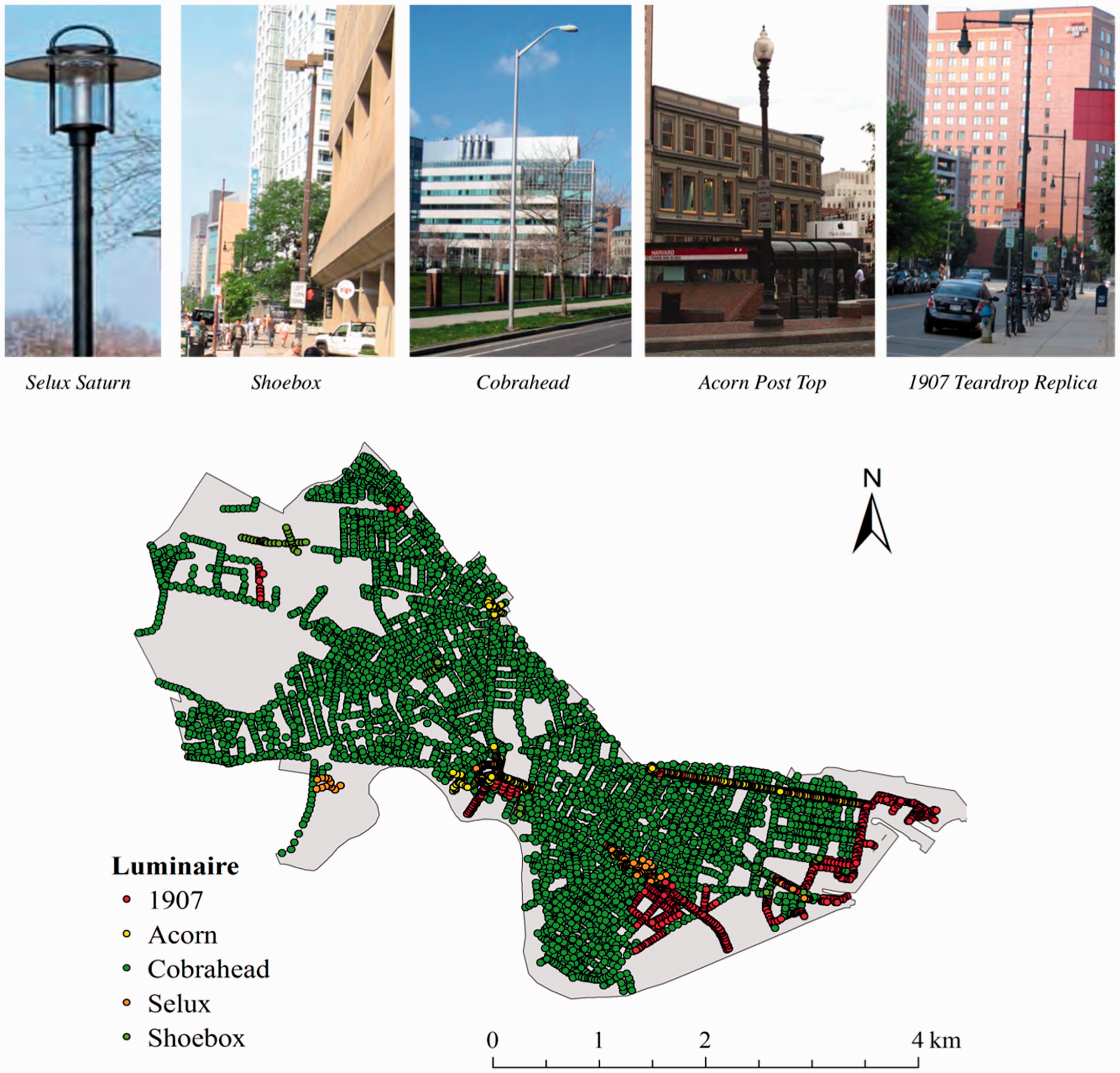
The spatial distribution of different types of luminaires in Cambridge, MA.
Different types of luminaires have different upward flux and downward flux. Table 1 presents the flux distributions of the different luminaires in the study area. The Acorn Post Top and the 1907 Teardrop Replica have upward flux, whereas the other types of luminaires do not have upward flux. These values describe the amount of light leaving each luminaire (lumens). Based on these parameters, we can calculate the flux of unwanted artificial light entering the night sky.
The characteristics of different types of luminaires in the city of Cambridge, MA.

Estimating the amount of wasted light entering the sky
There are two major types of unwanted light originating from the street luminaires entering the sky: reflected downward light from the ground, and the direct upward light from luminaires. Figure 3(a) shows the conceptual model of the unwanted light entering the sky in street canyons. Therefore, the amount of light entering the sky can be calculated as

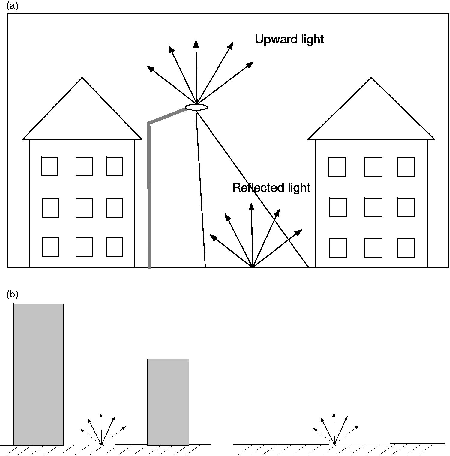
The model of the unwanted light entering the sky in street canyons.
The buildings and trees along the streets would block the reflected light from the ground entering the sky. Figure 3(b) shows the model of the unwanted reflected light entering the sky. The most common way to estimate the light within street canyons is to ignore all reflections, set a fixed value (Estrada-García et al., 2016), or to consider only the first reflection. This study assumes the ground is a Lambertian surface and the reflected light diffuses in the street canyons equally in all directions. Therefore, the amount of light should be further multiplied by the ratio of visible light at the sky point, which is the same as the definition of the sky view factor (SVF). As a dimensionless parameter of urban geometry, the SVF indicates how much sky is obstructed by buildings and tree canopies (Chapman and Thornes, 2004). The SVF also represents the ratio between radiation received by a planar ground and that from the entire hemisphere’s input radiation (Watson and Johnson, 1987). When the sky is totally obstructed, the SVF is zero, while the SVF is one when there is no obstruction. Thus, the SVF is a good parameter that encapsulates the many obstacles that influence the estimation of light pollution in urban areas, at the street level. The original SVF is defined as (Steyn, 1980)

Therefore, the amount of light entering the sky at the site of one luminaire can be calculated as

Estimating SVF using GSV panorama and a building height model
To separate obstruction effects of tree canopies on the unwanted upward light, we used the GSV-based photographic method and the building height model-based simulation method to calculate the “all-inclusive” SVFP and “building-only” SVFS, respectively (Li et al., 2018). The GSV-based photographic method allows us to consider the obstruction effects of both buildings and tree canopies along street canyons, while the building height model-based method considers only the obstruction of upward light by building blocks.
In the photographic method, we generated fisheye images for SVF calculation based on GSV panoramas. Figure 4 shows the generated fisheye images from the GSV panoramas based on a geometrical transformation. Based on the spatial distribution of the luminaires in the study area, we first collected GSV panoramas at the location of each luminaire. Considering the fact that GSV panoramas were captured densely along streets every 10 meters, the maximum mismatch distance between the locations of GSV panoramas and the luminaires would be less than 5 meters. It is therefore reasonable to estimate the SVF at the locations of street luminaires using nearby GSV panoramas. The object-based image analysis was used to classify the generated synthetic fisheye images into two major classes, the visible sky and the non-sky pixels (Li and Ratti, 2018). Based on the image classification results, SVFP values were further calculated as (Johnson and Watson, 1984)


The SVF values estimated by GSV panorama at different sites. SVF: sky view factor.
The SVFS values were calculated based on the simulation of sunlight path across the building height model. The building height model-based SVFS can be calculated as (Li et al., 2018)

Results
Figure 5 shows the spatial distributions of the upward and downward light from different luminaires in the study area. Streetlight luminaires in Cambridge radiate more downward light than upward light (Table 1). The central and the southeastern parts of Cambridge have much lower amounts of downward light than other parts of the city (Figure 5(a)). Different from the spatial distribution of the downward light, the upward light has a very distinctive pattern, in which the central and southeastern areas have higher upward flux level (Figure 5(b)).

The spatial distributions of the downward (a) and upward flux (b) from street luminaries in the study area.
In urban street canyons, both the buildings and street tree canopies act as obstructions and might block the upward light entering the sky. The SVF values indicate the openness of the street canyons, which also determine the light flux entering the night sky. Figure 6(a) shows the spatial distribution of the building height model-based SVFS with the consideration of the obstruction of building blocks only. The central and southern parts of Cambridge, including Harvard Square and Kendall Square, have significantly lower SVF values than other regions. This is due to the large number of high-rise buildings in those areas. Figure 6(b) shows the spatial distribution of the SVFP map using the GSV-based photographic method. There is no obvious pattern of the SVF distribution in the study area, when considering the obstruction effects of both buildings and street tree canopies.
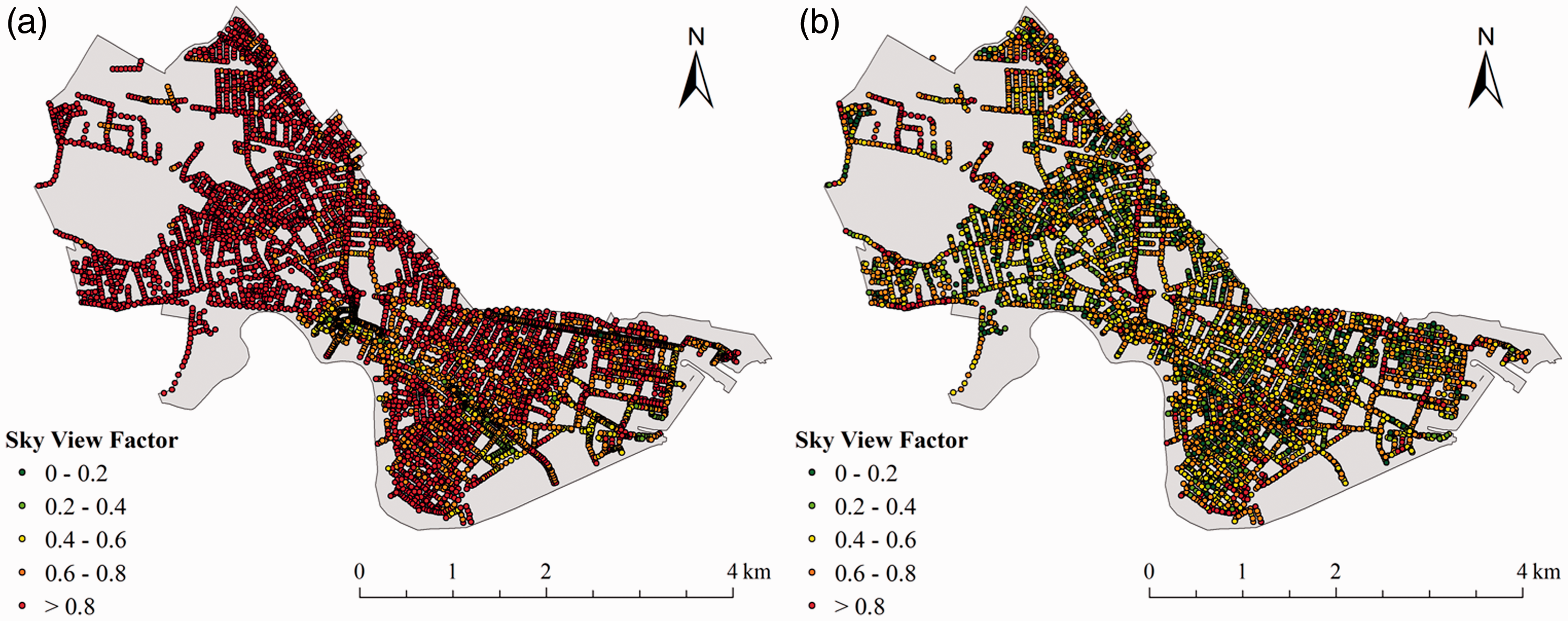
The spatial distributions of SVF in Cambridge, MA: (a) the SVFS map calculated based on a building height model with consideration of the obstruction of building blocks and (b) the GSV-based photographic SVFP map with the obstruction of both the building blocks and the street tree canopies.
Using the SVF maps and downward and upward flux from street luminaries as inputs, the model simulation results show that there are 7,499,067 lumens of light entering the sky of Cambridge in leaf-on season. Figure 7(b) shows the spatial distribution of the light flux entering the night sky in the city. The existence of the street tree canopy would enclose the street canyons and lower the SVF values, which would block or reduce the amount of light entering the sky (Formula (3)). Figure 7(a) shows the spatial distribution of the light flux entering the night sky if no street trees exist within street canyons. Table 2 shows the lumens change of upward light entering the sky from street luminaires under different scenarios. In the study area, the existence of street trees helps to decrease the SVF values by 31% and reduces by 31% the amount of unwanted light entering the sky. However, such unwanted upward light reduction by street trees would drop dramatically in winter, when street trees become leafless in the study area.
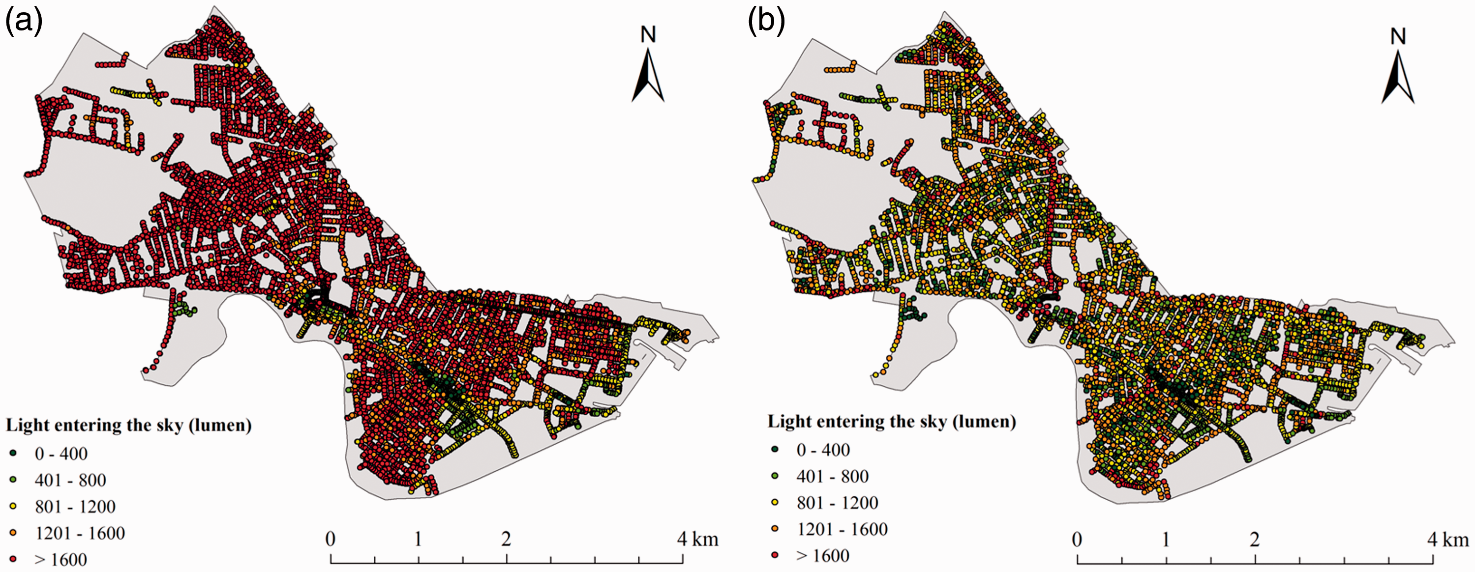
The spatial distribution of light flux entering the sky in Cambridge, MA: (a) the amount of light entering the sky with no obstruction by street trees and (b) the amount of light entering the sky from street canyons.
The amount of upward light entering the sky from street luminaires under different scenarios.
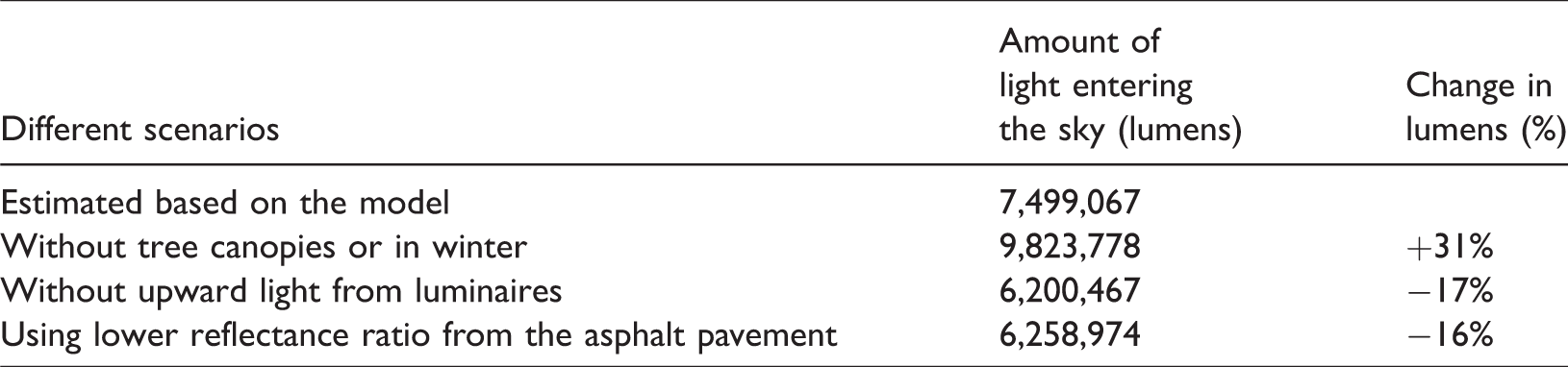
Replacing lighting spectra can reduce the effects of light pollution, on both humans, animals, and plants, and is recommended by some authors (Aubé et al., 2013). Other approaches include controlling the upward light, which is a direct way to curb the light entering the sky. Simulation results show that by simply using caps to prevent the upward light from the Acorn Post Top and 1907 Teardrop Replica, the amount of light entering the sky would decrease by 17% (1,298,600 lumens). Using materials with a lower reflectance ratio would also decrease the amount of light entering the sky. For instance, based on previous measurements, the reflectance ratio of asphalt is 80% of the reflectance ratio of concrete (Adrian and Jabanputra, 2005). In this study, if all pavements along streets were constructed of asphalt, the amount of the light entering the sky would decrease by 16% (1,240,093 lumens). In addition, reducing the amount of the downward light would also potentially decrease the amount of light reflected from the ground and entering the sky. However, the reduction of downward light deserves other specific studies to assess whether such a decrease meets the safety and comfort requirements of the visibility at the street level. Likewise, replacing all pavements with asphalt, with lower reflectance by higher energy absorption, might increase the ground temperature and consequently, influence the heat island effect.
Discussion
In an increasingly urbanized world, the night sky has become the privilege of a few. In Europe and the United States, “the night sky has become a smudged and meaningless background” (Nye, 2010: 9), in which artificial light has created its counterpart: artificial darkness.
The artificial light from street light luminaires is one of the major sources of light pollution in cities. Studying how to reduce light pollution is imperative for addressing the negative impacts of light pollution on human health and urban ecosystems, and for bringing the dark sky back to cities. In this study, we built a model to simulate the flux of unwanted artificial street light out of the street canyons in Cambridge, Massachusetts. The main goal was to propose a method to consider one of the important variables influencing the estimation of light pollution in urban areas: the urban obstacles, or physical features or urban canyons, such as buildings and tree canopy.
The street light luminaires and geospatial data representing the geometrical characteristics of street canyons were used in the simulation to estimate the obstructing effects of unwanted light that trespass street canyons. Different from previous studies that have used aerial and satellite nighttime imagery to estimate the amount of light flux, this study modeled and simulated the reflection and obstruction of the artificial light in street canyons based on ground-based GSV images. The developed model makes it possible to evaluate the impact of different streetscape features on the amount of unwanted artificial light entering the sky. The automatic procedures that are based on the publicly accessible and globally available GSV images make it possible to estimate city-wide light pollution effects with low costs for any cities with GSV imagery available.
The amount of unwanted light entering the sky caused by street luminaires is influenced by several factors, such as reflectance of street pavement, openness of the street canyons, and flux of luminaires. Reducing the light trespass into the sky can be achieved through lighting design, decreasing the reflectance of pavement, and increasing the obstruction within street canyons. Based on simulation results in Cambridge, in leaf-on seasons, the existence of street tree canopies contributes to the largest reduction in unwanted light, by as much as 31%. The existence of street tree canopies helps to enclose the street canyons and block unwanted artificial light from entering the sky. However, the obstruction effect would drop dramatically in winter, when most trees become leafless in higher-latitude cities, such as Cambridge.
Luminaire design would be the most direct way to curb the amount of unwanted artificial light entering the sky in cities. Cutoff luminaires that focus light downward where it is needed, and minimize the light spread upward into the night sky, could help curb light pollution. In the study area, where most luminaires are designed based on these principles, the modeled results show that using the full cutoff street lighting system with no upward flux would help to reduce the amount of unwanted artificial light by 17%. This number would rise even higher for cities with no full cutoff street light system. Reducing the amount of downward flux, while maintaining the visibility level of the street, would also help to reduce the amount of light entering the sky caused by the street luminaires. One solution that has been adopted by some cities, including the City of Cambridge, is to dim the street luminaires after a certain hour, when there are fewer people in the streets, and less lighting is needed. Indeed, dimming streetlights must be done while still keeping the required illuminance level for streets. In this realm, cities have been equipping street lights with sensors and LED bulbs, which can make such measures site specific, according to traffic and the presence of people, for instance (Álvarez et al., 2017).
Decreasing the reflectance of the ground would be another way to reduce the amount of unwanted light entering the sky. Special attention to landscape design and the use of different materials would help to achieve this goal. For instance, the reflectance ratio of asphalt is 20% lower than the reflectance of the concrete. Although the urban surface is heterogeneous and varies spatially in many cities (including the study area), we estimated that by using the low reflective asphalt, the amount of light entering the sky would be reduced by 16% in the city of Cambridge. However, using low-reflectance materials, as the pavement would also cause more solar radiation absorption on the ground, would further enhance the urban heat island effects and decrease the thermal comfort in cities. In addition, we are aware that it would be impractical to fully replace pavement materials in existing streets (such as those using concrete for pavement); still, the values described here using asphalt to curb the light pollution can provide some references for the design specification of new developments, with the clear goal of decreasing light pollution and, as an additional benefit, save energy.
As with most of the studies that estimate light pollution in urban areas, the built model described in this study is based on many assumptions, which could be violated in reality. For instance, the built model developed here was based on the assumption that the street trees would block the reflected light from entering the sky, and the street tree canopies are totally impenetrable to reflected light. We recognize that vegetation may not fully block the light reflected from the ground. Likewise, we acknowledge that this limitation would lead to an overestimation of the contribution of street tree canopies on light pollution mitigation. In addition, the obstruction is more effective in summer than winter, since most trees in the study area would be leafless during the winter season. Knowing the tree species and tree age in each location would increase the accuracy of this study. Nevertheless, the goal of this study was not to propose a fully accurate analysis for a specific site. Such specific analysis would be valuable for the city of Cambridge, but less valuable for other cities. Thus, our objective was rather to devise general tools to measure light pollution in cities using two basic and more easily accessible sources of information: the technical specification of the street lights, and the street canyon measured using publicly accessible GSV images. The goal is to provide a site-specific model that can be adapted by other cities.
In this study, we only focus on the upward light flux caused by the street lighting system entering the night sky, which is not identical to the full light pollution in cities. Light pollution also includes the glare, artificial light caused by other sources, such as traffic lights, commercial lights, residential lights, etc. Future studies should also consider the unwanted light caused by other artificial light sources.
Conclusion
This study quantitatively simulated and analyzed the light flux of unwanted artificial light into the night sky, proposing a case study in Cambridge, Massachusetts. GSV images, building height model, and street light specifications were used to simulate and estimate the light pollution originating from streetlights. The proposed method based on publicly accessible GSV images provides a new and scalable method to model and analyze city-wide light pollution with low costs. The simulation results show that the existing street tree canopies help to reduce the amount of the trespass of the light entering the night sky by 31%. Reducing the amount of the upward flux and downward flux would also help to significantly decrease the amount of light entering the sky. In addition, this study proves that using the landscape design within street canyons is also a very effective way to reduce the amount of unwanted artificial light entering the night sky. The study provides a reference for street light luminaire design aimed at curbing the street light-caused light pollution in cities. Finally, this study informs cities on defining policies to bring black sky back to cities, addressing health issues related to light pollution, and enhancing the overall quality of the urban environment and streetscapes.
Footnotes
Declaration of conflicting interests
The author(s) declared no potential conflicts of interest with respect to the research, authorship, and/or publication of this article.
Funding
The author(s) received no financial support for the research, authorship, and/or publication of this article.