



Abstract
The distance between home and school considerably influences the probability of children’s walking or biking to school (termed Active School Travel) which is a significant opportunity to promote their daily physical activity. This study investigated the shortest routes from home to school of primary school students and how the route distance can be shortened at the household level in Nanjing, China. We found that gated urban form results in significantly roundabout routes to school. In 2016, China issued the Opening and Prohibiting Gated Communities policy, subsequently the Healthy Cities Initiative, etc. which may leverage cities towards more healthy and sustainable transformations. In the light of these policies, we hypothesised that providing through access as management option, and opening new entries as reengineering option, would shorten school travel distance with minor costs. The scenario analysis shows that such management and reengineering adaptions would provide shorter and potentially less exposed routes for students. This study identifies how the existent urban form works against active school travel, and proposes how salutogenic pathways may be created in the gated urban form. The study, with transferability to other cities, can assist urban designers and policy makers in piloting urban (re)form incrementally and pragmatically to prompt active travel to schools.
Introduction
Active school travel (AST) through walking or biking is an important mechanism to increase the daily physical activity for schoolchildren in urban areas, an integral aspect of healthy and sustainable cities. Promoting AST has been emerging public policy in many cities worldwide, some of which have been successfully translated into supportive infrastructure projects like Safe Route to School in the USA and Europe (Banerjee et al., 2014; McDonald et al., 2014). Such investments, aiming for facilitate students’ school travel, have received increasing support and budget as a measure responding to vicious cycle of school commutes recently as of the following three issues. First, the home-to-school travel distance has steadily increased due to urban sprawl and school mergers. Second, peoples’ commuting mobility has been increasingly car-dependent, resulting in traffic congestion, pedestrian injury and poor air quality exposure. Third, health issues such as obesity and depression have been brought on by insufficient physical activity, especially walking (Banerjee et al., 2014; McDonald et al, 2011, 2014; McMillan, 2005; Rothman et al., 2017; WHO, 2018).
Many empirical studies have verified the substantial role of the built environment in either prompting or limiting AST, such as home-to-school distance, intersection density, street connectivity, land use mix, traffic calming, landscape affordance, weather, traffic noise and volume (Clark et al., 2015; Giles-Corti et al., 2011; Ikeda et al., 2018; Stewarta et al., 2012; Su et al., 2013). Compared to other built-environment factors, distance (either actual or perceived) is the dominant reason that influences how children travel to and from school in many countries (Giles-Corti et al., 2011; Hume et al., 2009; Rodríguez-Rodríguez et al., 2017; Rothman et al., 2017; Stewarta et al., 2012; Sun et al., 2018; Wong et al., 2011). McDonald (2007, 2011) found a strong negative relationship between distance to school and the rates of AST. Noticeably, AST was consistently lower for travel beyond 1600 m (approximately one mile). The one-mile threshold is also supported by empirical studies in American and European cities (Faulkner et al., 2010; Rothman et al., 2014; Salmon et al., 2007). At a distance of more than two miles, only 1.7% of K-8 graders (age 5–14 years) walk or bike to school (McDonald et al., 2011). Increasing travel distance alone may account for half of the decline in walking to school between 1969 and 2001 in the United States, while similar trend emerges in other countries including developing ones (Banerjee et al., 2014; Larsen et al., 2015; McDonald, 2007, 2011; Pang et al., 2017; Rodríguez-Rodríguez et al., 2017; Rothman et al., 2017; Zhang et al., 2017).
School catchment are usually delineated by service radius, namely the Euclidean (straight-line) distance between the school and home, which are also routine accessibility measure of other facilities in urban planning. Many countries issued codes or guidelines of school catchment to ensure reasonable school commute distance (Giles-Corti et al., 2011; Ikeda et al., 2018; McDonald, 2011). The service radius of a primary school (age 6–12 years) in China is 500 m, according to the National Code for Design of School (GB 50099-2011). However, many students actually have to travel much longer than the Euclidean distance between school and home. The shortest route distance, the distance a student must travel to get to and from school, is commonly applied to accessibility evaluation and travel mode prediction by prudent researchers (Banerjee et al., 2014; Buliung et al., 2013; Clark et al., 2015; Giles-Corti et al., 2011; Panter et al., 2010; Schlossberg et al., 2006; Timperio et al., 2006).
The shortest routes are determined by the location of schools and homes as well as the road network in between (Clark et al., 2015; Dessing et al., 2016). Cul-de-sacs, property walls, topographic features, etc., all make the routes more sinuous, therefore much longer than the Euclidean distance, sometimes even beyond the normally acceptable travel distance as of 1600 m/1 mile (Schlossberg et al., 2006, 2015; Sun et al., 2018). Such detours are usually measured by the pedestrian route directness, i.e. sinuosity coefficient, to indicate the permeability of street networks (Buliung et al., 2013; Hess et al., 1999; Stangl, 2012). Unfortunately, school’s service radius and street impermeability have both increased in many areas over the last decades due to gated developments, car-oriented road networks and urban sprawl with bigger blocks (Charmes, 2010; Sun et al., 2017). Some empirical studies found that route preference and wayfinding capacity vary across students which may cause considerably different travel distance to school. Avoiding heavy traffic or unsafe areas, walking with friends, experiencing favourite environments, or distortions of cognitive maps may result in a longer journey than the shortest one (Banerjee et al., 2014; Buliung et al., 2013). On the other hand, some students may travel through vacant lands, communities, buildings, via routes even shorter than the regular shortest ones, as Clark et al. (2015) found in suburban neighbourhoods in Canada.
Informal footpaths, pedestrian and bicycle access at the end of cul-de-sacs and through vacant land, and green space, may considerably reduce the school travel distance. Deviating from regular routes, shortcuts are usually underappreciated for wayfinding effort and safety concerns associated with its informality. Nevertheless, ignoring shortcuts may underestimate the walkability of some neighbourhoods (Clark et al., 2015; Giles-Corti et al., 2011; Sun et al., 2017). Hitherto, only a few AST researchers have incorporated paths, sidewalks and shortcuts into circulation network studies to measure connectivity (Clark et al., 2015; Giles-Corti et al., 2011; Larsen et al., 2009, 2012). Adopting or creating shortcuts for pedestrians, particularly students, has received little attention in the development policy and urban design practice (National Transport Authority of Ireland, 2015).
Creating shortcuts for non-motorised travellers, to improve the permeability of urban form with temporary expropriation of community land, may be necessary and feasible in many cities especially of China. Chinese cities are characteristic of ubiquitous superblock, which mainly consist of gated communities and danweis (working unit). Over 80% of community housing developments are gated since the 1990s (Miao, 2003). Cordoned off by a mixture of walls, fences, plantings, gates and sentry box, these gated compounds occupy sizeable blocks, which usually reach 300 and 500 m in length and width. Typically, the residential density is no less than 120–180 households per hectare, with mid- to high-rise residential towers sitting compactly in these communities. The sizes of danweis vary from as small as a tennis court to as large as a several square kilometre campus (Kan et al., 2017).
In China, gated superblocks have been shaped by the traditional legacy of urban form, inheriting international urban form models and contemporary political social and economic circumstances (Xu and Yang, 2009). The Soviet models of working unit (microrayon) and their combinations have dominated community development patterns in Chinese cities since the 1940s (Miao, 2003). From the 1990s, market-led commodity housing development prevailed with gated communities being modelled on neighbourhood unit, particularly in the form of Radburn, New Jersey, USA (Charmes, 2010; Xu and Yang, 2009). These community models were gradually translated to China mainly for two reasons. First, developers catered to the residents’ security concerns and desire for political control of their neighbourhoods with gates and walls. Second, the central and local government strongly advocated for gated communities to shed the responsibility in the provision of public facilities such as constructing and maintaining inner roads (Xu and Yang, 2008). Simultaneously, local government kept the momentum of developing gated community to reinforce governance and social stability (Miao, 2003; Kan et al., 2017). Despite the socio-political rationale in the creation of gated communities, there are drawbacks of gated mess including fragmented urbanism, low connectivity and social segregation. Furthermore, the boundaries may impair pedestrian accessibility especially of the elder and disabled, therefore contributing to more car-dependence. Meanwhile, the roads between blocks of gated communities tend to be oversized with limited connectivity, which further contributes to automobile traffic, congestion and air pollution (Kan et al., 2017; Sun et al., 2017).
On the other hand, administrative power, social political norms and economic growth make re-engineering cities more feasible for local governments in China than their western counterparts. Such re-engineering in Chinese cities may have new targets due to a recent ungating policy and the relevant policies latterly. In February 2016, China’s national government released new State Council Guidelines for Urban Planning and Management for more compact, liveable, green and sustainable cities (Normille, 2016). The guidelines prohibits construction of any new gated communities and requires existent gated communities to be opened gradually, to create a denser urban road network (Kan et al., 2017; UTETCMHC et al., 2019). This policy is an overhaul on gatedness with the primary purpose of accommodating motorised traffic, which contradicts the residents’ aversion to noise, pollution and injury risk (Sun et al., 2017). Theoretically, the state can expropriate the land granted to individuals and communities without challenge, for state-owned land systems in urban areas of China (Kan et al., 2017). Local governments have claimed lands for the development of new infrastructures or even commodity housing, sometimes by demolishing numerous neighbourhoods and even registered historical-cultural sites in the last decades.
In 2017, China’s government issued the National Strategy of Healthy China (NSHC) initiative with Healthy Cities designated as a subsection. The NSHC prioritises health issues in all national and local policy, requiring health impact assessment as integral procedures for new developments and policies. Local plans like Healthy Shanghai 2030 have promoted a 15-minute Community Life Circle for residents’ active living with an emphasis on walking accessibility. Noticeably, many relevant planning proposals and studies have been based on straight-line distance, hence would omit the latent distance obstacle due to gatedness. Adapting the management and built environment for non-motorised through-travel form, which may provide shortcuts for students within the framework of the new policies in China, have thus far received little attention. In the light of the recent urban policies in China, the aims of this paper are twofold: to measure the school–home distance at the household resolution with a case study in Nanjing; and to explore the potential of shortcuts in the light of the new ungating policy. The first aim, as a descriptive approach, will unravel the social cost of gatedness, while the latter, as a prescriptive one, will explore the potential of temporary land use via urban design tactics under the normative drivers.
Methods
Study area
Nanjing is a megacity with a population of over eight million in the east of mainland China. The study area is 463.3 hectares in the northeast of Nanjing, surrounded by the Purple Mountain, Xuanwu Lake, arterial roads, highway and railways. Such configuration confines daily active transport mainly within a distinctly defined area (Figure 1, Supp Fig. 1).
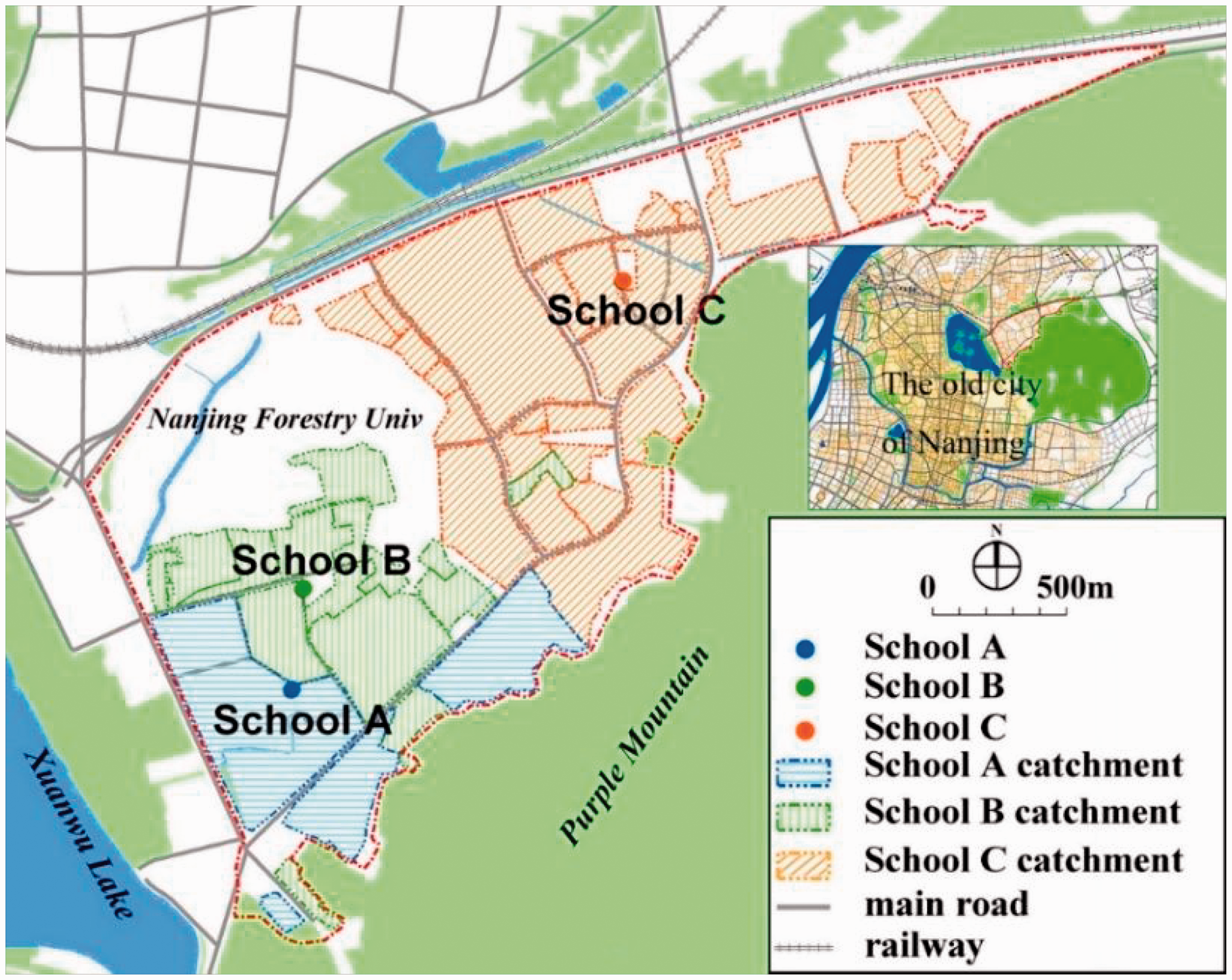
School catchments in the study area.
There are three primary schools, each of which has an exclusive catchment, covering 22,715 properties totally in the study area (Figure 1). The ‘nearby enrollment policy’ requires a student to attend the school in which one’s parental hukou (household registration) and property ownership are located within. Students can have alternative school options only if their family has more than one property to transfer hukou for enrolment eligibility, which is only affordable for a handful of high-income families (Feng and Lu, 2013; Yuan et al., 2018). For students living in the study area, such school choice will make AST unreasonable due to the extra-long commute distance and crossing highways. In 2017, there were 2305 students enrolled in the three schools (Table 1), equivalent to about one primary school student enrolled out of every 10 properties.
Catchment areas, properties and enrolment in the study area (2017).
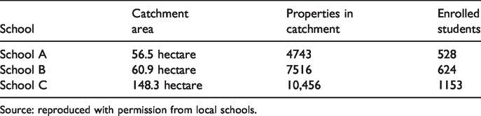
Source: reproduced with permission from local schools.
Guarded gates and property walls of danweis and communities in this study area are ubiquitous, as in other areas in Nanjing. For new built or lofty communities, an outsider’s through-travel is usually restricted if not forbidden by the gatekeepers. Universities, colleges and old communities sometimes allow outsiders to travel through on foot or by bicycle, but access controls with entrance bars and guards may frustrate an outsiders’ propensity to travel through (Supp Figs. 2 to 5).
In the study area, students go to school by car, bike and walking. School bus service for public schools is not available in Nanjing, as in most Chinese cities. The three schools are not intentionally served by public bus for no stops is 500 m within the schools, so few students take bus to school or home as we observed.
Three scenarios
We presumed three urban form permeability levels as follows, then tested school travel distance across the three scenarios.
Scenario 1
Any outsider’s through-travel is restricted inside the gated communities and institutions. In this scenario, school commuters (students and their chaperons) cannot travel through communities or danweis unless they are residents there, due to access restrictions. They travel along the shortest routes via existing formal walking and bike paths which are usually along the main roads. This scenario is very close to the existing situation of the study area and similarly other places in Chinese cities.
Scenario 2
School commuters’ non-motorised through-travel is allowed in the gated communities, and danweis such as universities and other yards of institutions. In this scenario, the pedestrian pathway within danweis and gated communities may shorten the journey in Scenario 1 if these multi-entry gated compounds are located between the schools and students’ homes.
Scenario 3
Based on routes in Scenario 2, ‘short-cuts’ connecting the inner and outer routes are proposed to provide even shorter routes to school. The short-cuts are new entries opened in the boundary walls and fences, or pedestrian bridges over streams. The locations of short-cuts were determined, with field investigation, based on the following criteria to lower impacts on stakeholder and safety risk of students, thus maximising the implementability: (a) to take advantage of vacant land especially containing public and semi-public spaces; (b) to avoid mutual disturbance between through-travels and business; (c) to shun military land for almost impossible access permission; (d) to limit the amount of short-cuts, and to minimise expropriation of community land usage rights. With intensive fieldwork and spatial pilot tests, we initially determined 95 short-cuts in the area.
Data preparation
We derived road network and building footprints from the official urban planning documents, then overlaid these vector format layers in GIS (ESRI ArcGIS 10.2). We identified sidewalks on both sides of the roads and pedestrian pathways within all the gated communities and institutions, as basic active travel network for Scenarios 1 and 2. Also, we hypothesised short-cuts for connecting the pedestrian and bicycle routes within and outside the gated compounds. These proposed shortcuts, linking the inner and outer pathways, were combined with urban paths and inner pedestrian routes to complete the bespoke circulation networks for Scenario 3.
Students’ home locations were designated by points at the communal doorways connecting each apartment, simultaneously connecting to the pedestrian route network. In most cases, the distance between a doorway to a household is merely the stairway which was not been taken into account in this study. School locations were represented by points at the school gates.
The whole sidewalk network, path network within and outside the communities and danweis gates, and proposed short-cuts were verified with field investigation in 2017. The doorway points of buildings were also checked by sampling across communities to verify the position accuracy. After that, the whole pedestrian network was created and validated in ArcGIS 10.2. There were 9509 route segments with total length of 194 km and 8728 junctions in the circulation network of the study area. There were 22,715 points representing all the households of this area, with generally 10–12 points that share the same X–Y position since typically 10–12 households living in 5–6 floor apartment buildings share a common doorway.
Measurement and analysis process
For the three scenarios, we first calculated the shortest possible routes in the pedestrian networks and the corresponding distances from each household to the assigned school with ArcGIS Network Analysis tool (Figures 2 and 3). We derived the Euclidean distance between each household point and the relevant school from their X and Y coordinate. The route’s pedestrian directness ratio (PDR) was calculated by dividing its distance by the corresponding Euclidean distance.

Shortest route case of School B in the three scenarios.

Shortest route case of School C in the three scenarios.
The length of each route’s proximity to arterial roads was measured as an approximate prediction of potential exposure to traffic fumes and noise since the arterial roads usually have much more traffic volume than the inner roads of institutions and communities. In ArcGIS, we first delineated all the curbs of arterial roads, then classified the paths as exposed to arterial roads or not, according to whether they were within a 10-meter buffer of the arterial roads’ curbs (Khan et al., 2018). Each household’s routes to the school in the three scenarios were broken into segments, then spatially joined with the arterial road segments to capture the routes’ sum length of proximity to the arterial roads. Cases in Figures 2 and 3 show the three route scenarios from home to school, with Table 2 indicating the distance across the three scenarios.
Route distance (m) of the shortest route cases.

To count how often a road or path segment is travelled by the shortest routes, we joined the segments of the shortest paths with the underlying base network in ArcGIS. The travel frequency and the redistribution of the road segments across scenarios were then sorted and visualised for a rudimentary yet more discernible comparison. The statistics were calculated within ArcGIS and R Studio.
Results
Distance and detour
In this study area, there were 9606 properties (42.3% of the total) beyond 500 m straight-line distance to school as required by National Code for Design of School, of which 6586 properties in School C’s catchment predominated. There are palpable differences of travel distance and PDR between the three school catchments (Table 3).
The distances to school and PDR in the three scenarios.
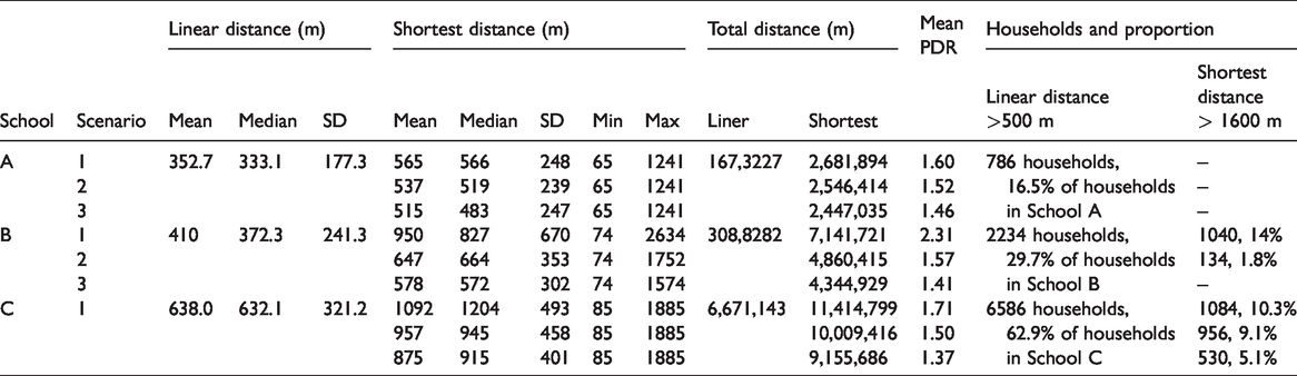
In Scenario 1, the mean and median shortest home-to-school distance of properties in School C’s catchment are much longer than those in School A and B’s. For Schools B and C, there are 1040 (14%) and 1084 (10.3%) properties respectively beyond the 1600 m shortest routes to school which may address considerable barrier to primary school students’ AST (McDonald, 2007, 2011).
The routes’ mean PDR of the three schools’ catchment are all above 1.6, indicating the network connectivity of this area is averagely lower than that of typical suburban neighbourhoods in the USA with PDR normally no more than 1.6, and much lower than the well-connected grids of pre-war neighbourhoods in the USA (PDR of 1.3). The pedestrian network connectivity in USA suburban area is not the optimal model – denser European neighbourhoods have lower PDR (Hess et al., 1999; National Transport Authority of Ireland, 2015; Stangl, 2012).
In Scenario 2, the mean distances of the shortest routes drop substantially, particularly for School B, comparing to Scenario 1. There are 906 (7382 vs 6476) more properties as of 12.1% share within School B’s catchment (max distance 1600 m) when through-travel is allowed. For School C’s catchment, the properties and percentage drops are 128 (9500 vs 9372) and 1.22% respectively. This implies that travelling through danweis and gated communities will provide much shorter routes, especially for students in School B’s catchments. In Scenario 3, the mean distance and PDR of the shortest routes decrease further than those of Scenario 2, with School A, B, C’s mean distance dropping 50 m (8.9%), 372 m (39.1%) and 217 m (19.8%), respectively, compared to Scenario 1. Only 530 properties (5%) assigned to School C are beyond 1600 m shortest route distance to the school.
From Scenarios 1 to 2, there are 1532 properties (20.4%) in School B’s catchment and 715 properties (6.8%) in School C’s catchment which have the shortest distance drop more than 500 m, falling within 1000 m. From Scenarios 1 to 3, there are 2146 (11.9%) and 1106 (6.2%) properties, respectively relevant to Schools B and C, have the shortest distance dropping more than 500 m, falling within 1000 m. Such reductions probably would promote more students’ AST. In Scenario 3, the proposed short-cuts lead to more journeys through the gated communities and danwei. Likelihood of being travelled, i.e. travel frequency, suggests potential performance of the short-cuts. Among the initially proposed 95 short-cuts, 29 short-cuts are not passed, while the other 66 short-cuts are passed at a significantly different frequency (Table 4). The most would-be travelled short-cuts and the consequent distance reduction can be used to assign the intervention priorities. Supp Table 1 shows the distance reductions respective to the three short-cuts most travelled, revealing that the through-accesses and short-cuts would both contribute to curtail the shortest routes.
Travel frequency of the short-cuts in Scenario 3.

From Scenarios 1 to 2 and 3, the shortest routes’ distance decrease unproportionally among the three schools (Table 3). Also there are differences of shortening the distance between the catchments in Scenarios 2 and 3 (Table 4). Such disparity can be attributed to the three schools’ various catchment sizes and urban form. The area had witnessed increasingly rapid development since the 1980s when it was at the periphery of the city. Institutional land use was first designated along the thoroughfare. School A and B’s catchments mainly consist of the institution affiliating communities. School C’s catchment area constitutes mainly communities of commodity housing rapidly developed since the 2000s. Besides, the delineation of the school catchments was also involved, administrative and financial resources of which the powerful institutions (danwei) and real-estate developers may successfully negotiate ‘better’ schools for their employee or residents. The discontinuous, irregular school catchment were therefore formed, definitely not optical in terms of students’ proximity, yet seemingly lasting for long term.
Road exposure
Scenarios 2 and 3 would provide shorter routes for many properties, which inevitably redistribute the being-travelled frequency of road segments. The redistribution may also influence the students’ exposure to traffic on the arterial roads (Supp Table 2).
For Schools A and B, there are obvious exposure drop from Scenarios 1 to 2, comparing to slight changes from Scenarios 2 to 3. Travel frequency of arterial roads significantly drops in School C’s catchment, which may alleviate students’ exposure risk to traffic fumes, noise and injury. In Scenario 1, there are 13,106 (58%) properties within the 500 m linear distance to school. Considering the enrolment ratio of students, and hypothesising they distribute evenly, at the individual level, short-cuts may promote distance-sensitive active travel of students, especially when the distance falls considerably to below 1600 m; at the collective level, about 382 km travel is reduced in Scenario 2 and 147 km is further reduced in Scenario 3 for a one-way trip of the existent students. If all the students walk to school with speed of 4.5 km per hour, the exposure time to traffic pollution would decrease 52.1% from 396 hours to 189.7 hours (Supp Table 2, Figure 4) in single one-way trip which probably lessens health risk, given these shortcuts would be implemented and travelled as Scenario 3, with the same hypothesis.
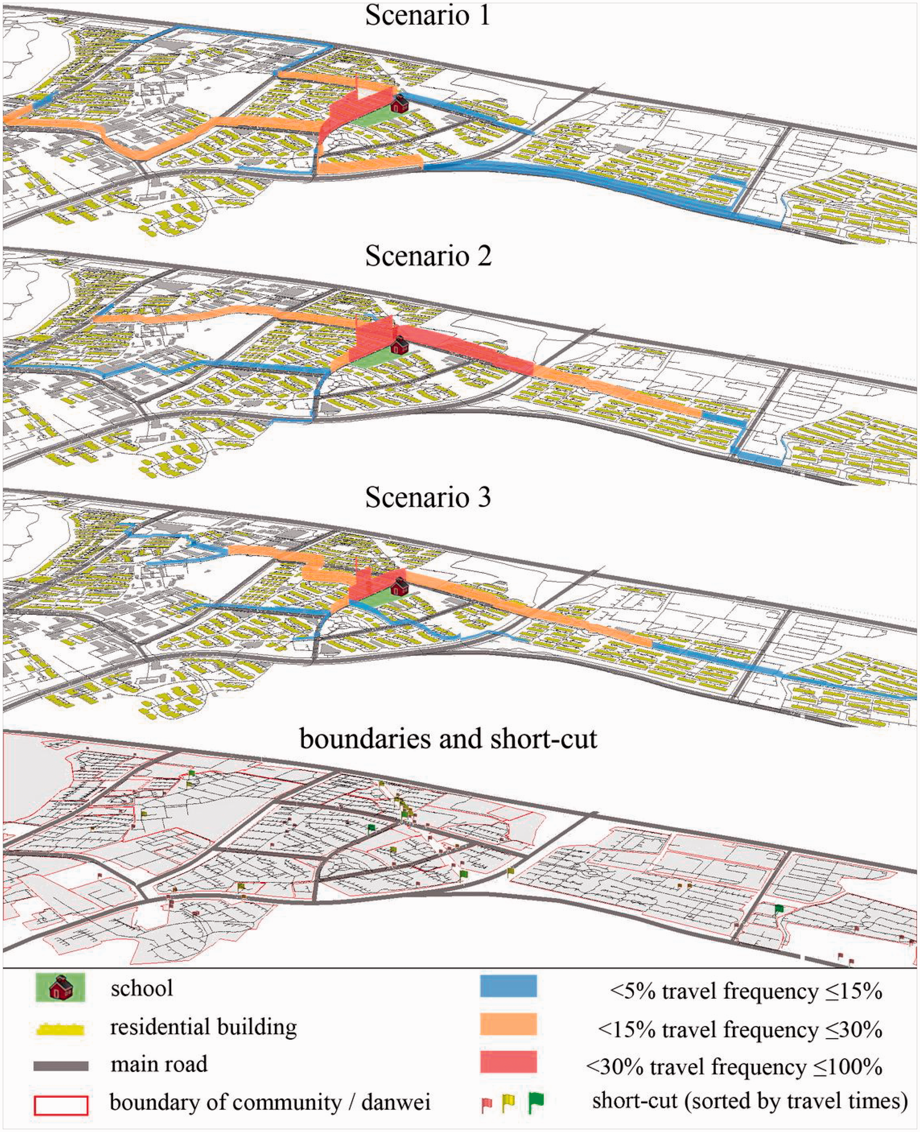
Travel frequency percentage distribution of the road segments in School C’s catchment.
Discussion
In the light of the Ungating policy issued in 2016 and 2017 NSHC, this study has sought to explore how the school commuting distance can be shortened by exploring scenarios with common urban form of Chinese cities. The results provide three key contributions to the literature by: (1) identifying the shortest travel distance from home to school of students at a household level in a meso-scale area; (2) revealing how proposed short-cuts, through gated communities and danweis, could potentially reduce the travel distance; and (3) suggesting reform approaches at the micro-scale to provide shorter and less exposed commuting routes for students in the light of the recent urban policies in China.
The potential of shortcuts
In the study area, there were 9606 (42.3%) properties beyond service radius, moreover the shortest route distance may be much longer than the Euclidean distance for students to adopt AST. It is financially impractical to build new schools to meet the school sitting code within the study area. The current school policy in China is inclined to enlarge school size rather than building more small-sized schools. Extra-long travel distance to schools, parks, etc., due to detours in gated urban form is ubiquitous in Chinese cities, and probably common in other countries (Scoppa et al., 2018). Such time and physical burden, once beyond some threshold, would inevitably lower the propensity of active transport. As trip generators, students usually influence other family members’ (usually mothers in the USA, and grandparents in China) travel distance and modes (Banerjee et al., 2014). Therefore, reducing distance may facilitate more active travel of larger population, alleviate traffic congestion, and hence reduce fuel consumption and traffic fumes exposure especially due to the cold start and short-distance trips of cars. Our results demonstrate the cost of the sinuous routes created due to gated urban form. By virtue of the 2017 National Health Strategy of China and other recent urban policies, we argue for a reasonable permeability for pedestrians and cyclers; school-age students in particular should be a primary consideration for both new development and retrofitting communities. Considering the potential deduction of exposure as we estimated, urban form permeability for active travellers should be brought into the Health Impact Assessment and urban form adaption.
Prospective optimisation
Students’ commute are time and direction predictable, making it easy to identify the location and the priority for through-travel and short-cuts. Detailed measures can therefore be developed when examining specific routes and communities. Researches show that social danger is one of parents’ concerns for students’ commute. While parents may perceive that it is safer for students to travel within communities (Sun et al., 2018), their attitudes towards travelling through alien communities and danweis are still unknown. In China, the high population density, and with elder residents sauntering in communities, may provide ‘street eye and neighbourhood surveillance’ (Jacobs, 1961). Besides, surveillance cameras, now deployed pervasively throughout Chinese cities, monitor communities day and night probably making the students and their parents, the residents and the staff of danweis feel safe. Special signs indicating the short-cuts’ location and direction would assist commuters’ wayfinding and sense of safety, and awareness of the communities’ contribution.
In this study, we hypothesised students would choose the shortest route to school. This is not always the case since heavy traffic or unsafe areas, a certain environment, distorted cognitive maps or walking with friends may lead to students’ travel along the non-shortest routes (Banerjee et al., 2014; Buliung et al., 2013; Duncan and Mummery, 2007; Larsen et al., 2012; Timperio et al. 2006). Therefore, further investigation and even real-time monitoring may provide detailed information for justifying utilising inner pathways and optimising the routes with less noise and pollution (Hankey et al., 2017; Khan et al., 2018). The optimal routes may be not the shortest if a holistic solution is considered, as some audit tools or walkability indices imply (Dessing et al., 2016; Giles-Corti et al., 2011), but hopefully more shorter routes would be available if policy-makers and urban designers take advantage of the Ungating policy creatively and pragmatically.
Reengineering the urban form for temporary land use
In the 20th century, exclusionary residential territories exist along a continuum, ranging from cul-de-sacs, environmental areas and gated communities (Charmes, 2010). Globally, individuals retreating to an enclaved community seem decisively endorsed and propelled by the political-economic transformation of neoliberalism towards privatisation. The pervasive trend of gated communities in many countries may continue and become even stronger (Xu and Yang, 2008). Although somewhat reduced and dismantled since the 1990s post-socialist era, gated danweis still exist ubiquitously in many Chinese cities. Therefore, gated compounds in China are both a legacy and the norm, which policy makers and urban planners have to confront and figure out how to tackle for the long term.
China’s Ungating policy will provide normative drivers of urban transformation which although might seem unfeasible or even illegitimate in many countries for the private property ownership. However, the imminent implementation of this policy will be critical for the future sustainability of Chinese cities, which, it is estimated, will have to accommodate 255 million new migrants by the 2030s. There will not be any ‘one-size-fit-all’ solutions since the gated communities and urban context vary from city to city, neighbourhood to neighbourhood. Comprehensive as well as incremental interventions are critical for the huge ungating experiment in China proposed by the recent policies.
Allowing non-motorised access through gated communities especially for students would be more acceptable for the community residents if designed in consultation with local residents. Scenarios 2 and 3 in this study provide a lens of adapting management and reengineering the urban form for better accessibility, with temporary land use as school travel corridors. As a critique of the status quo and a catalyst for change, the temporary use of under-used land and space, whether public or private, offers new models of development and alternative experiences of places, and provides local communities and activists a place as participants in urban transformation (Madanipour, 2018). Sharing the inner routes for transient through-access may make better use of land in high density urban areas which is advocated with the recent urban policies. The tentative proposals in this study may reassure resident’s concerns over through-traffic and wider safety issues, which are regarded as the main barriers to implementing the Ungating policy in China.
Limitations
This study has several limitations. The study was restricted to a single area in Nanjing, a megacity in China with a high population density. The results and proposed scenarios may only be generalisable to city areas with similarly gated urban form. Population information, address and socio-economic status of households are restricted and difficult for researchers in China to obtain. Therefore, we ignored the actual distribution of students and calculated each properties’ distance to school. For the long term, there is rationale of such generalisation since the exchange rate of properties in many schools’ catchments are pretty high (Feng and Lu, 2013; Yuan et al., 2018). There is still limited knowledge of school children’s travel behaviour in China (Kerr et al., 2016; Zhang et al., 2017). We assumed that the preferred route was the shortest one and shorter routes would facilitate AST and lessen exposure risk. A comprehensive survey of households, along with various community stakeholders, should be conducted in the future to confirm such assumptions. Social support and public participation in initiatives such as Walking School Buses (Mendoza et al., 2011, 2012) and Kid Watch (Banerjee et al., 2014), critical for school travel mode shift towards AST, are still underdeveloped in China. Also, the real-time minoring of air quality and noise at micro-scale would provide critical information to justify, pinpoint and calibrate the optimal routes. Health impact assessment and social impact assessment are also pertinent for predicting and evaluating the outcomes.
Conclusion
This study investigated how the gated urban form detours school commute routes, taking case area in Nanjing, China. The gated compounds cause significant sinuous routes to school. Through-travel and short-cuts would provide much shorter routes to school, alleviating individual exposure to vehicle route. The scenario analysis unravels how the salutary shortcuts can be exploited from the adverse urban form in the light of urban re(form) policy in China.
Healthy China, as a national strategy since 2017, has received the attention from multi disciplines, as well as tremendous financial supports. In July 2019, the State Council issued Opinions on Implementing Healthy China addressing the priorities of students, plus collaborating and sharing across all sections as a critical principle. These policies provide an encouraging context for the proposal in this study. Our Scenarios 2 and 3, allowing students and their chaperons’ travelling through superblocks composed of gated communities, if practiced, would facilitate shorter and less-exposed routes to school which can be extended to other areas predominated by gated communities. Students’ travel through, will probably exert less impacts to the communities compared to opening up for motorised transport, alleviate stakeholders’ watchfulness or even resistance, cultivate social capital locally by collaborating and sharing, and hence probably energise the (reluctant) implementation of the Ungating policy since 2016.
Supplemental Material
sj-pdf-1-epb-10.1177_2399808320982303 - Supplemental material for Exploring the potential of urban (re)form: Modifying gated communities to shorten school travel distance in Nanjing, China
Supplemental material, sj-pdf-1-epb-10.1177_2399808320982303 for Exploring the potential of urban (re)form: Modifying gated communities to shorten school travel distance in Nanjing, China by Lingyun Han, Zhen Xu and Clive Sabel in EPB: Urban Analytics and City Science
Footnotes
Declaration of conflicting interests
The author(s) declared no potential conflicts of interest with respect to the research, authorship, and/or publication of this article.
Funding
The author(s) disclosed receipt of the following financial support for the research, authorship, and/or publication of this article: This work was supported by the Humanity and Social Science Foundation of Ministry of Education (18YJCZH043) and NSFC (52078254).

Supplemental material
Supplemental material for this article is available online.
References
Supplementary Material
Please find the following supplemental material available below.
For Open Access articles published under a Creative Commons License, all supplemental material carries the same license as the article it is associated with.
For non-Open Access articles published, all supplemental material carries a non-exclusive license, and permission requests for re-use of supplemental material or any part of supplemental material shall be sent directly to the copyright owner as specified in the copyright notice associated with the article.
