



Abstract
Designing urban areas that provide smaller distances to their amenities is a key factor toward more walkable environments. Moreover, this is a critical aspect of climate-resilient urban planning since it is broadly assumed that areas with greater walkability discourage automobile usage and reduce CO2 emissions. Generative and data-driven design approaches, in turn, increase designers’ ability to explore wider sets of potential solutions. In this sense, identifying designs with an optimized performance out of the vast possibilities that computation can provide is crucial. Shape grammars are a formal method of shape generation that facilitate the elaboration of complex patterns and meaningful designs. This paper hypothesizes that coupling shape grammars with multi-objective optimization can help address trade-offs and decision-making in urban design. It focuses on the pedestrian accessibility and infrastructure cost (as estimated by cumulative street length) trade-off in urban fabrics as a case study to verify the suitability of a grammar-based optimization approach for more dynamic and efficient solution-finding in urban design. Our findings suggest that a grammar-based optimization approach is helpful in addressing urban trade-offs as it could be used to filter the design space and provide optimal alternative fabric layouts with increased pedestrian accessibility and decreased infrastructure cost.
Introduction
Adopting generative, parametric, and data-driven design approaches increases the ability of designers to rapidly explore a wide range of potential solutions. However, robust strategies are needed to identify designs with better performance out of the vast possibilities generated through computation. In this context, computational optimization (CO) is increasingly used to solve complex design problems, although CO techniques at the urban design scale have been limited compared to architecture due to increased complexity and computation requirements. Shape grammars (SG) are a formal shape generation method that consist of a set of rules that apply recursively to an initial shape to generate a design language (Stiny and Gips, 1972; Stiny, 1980), facilitating the elaboration of complex patterns such as urban fabrics. SG can be implemented to describe a corpus of existing designs, explain how to generate new designs in the same language, or create new design languages (Duarte and Beirão, 2011). SG can produce design spaces with considerable complexity and diversity, with the design space being the set of potential solutions for a specific problem (Brown 2016, 2019) arranged by a multidimensional combination of input variables, even beyond what a designer might initially conceive.
Existing research has demonstrated the possibility of combining shape grammars with optimization to find high-performance designs. For example, Shea and Cagan (1999) explored shape grammars and simulated annealing to expand the range of solutions in roof trusses’ conceptual design. Mckay and Pennington (2006) brought together shape grammars and evolutionary algorithms to generate and evaluate new product shapes. Caldas (2011) combined genetic algorithms, energy simulation, and shape grammars to generate energy-efficient patio house designs. Granadeiro et al. (2013b) developed an indirect representation for optimizing solutions within a shape grammar for Frank Lloyd Wright prairie houses.
These studies suggest potential for moving to the urban scale. Cities concentrate 55.71% of the world’s population (United Nations, 2018) and are responsible for over 70% of global CO2 emissions, with fuel combustion in motor vehicles creating up to 75% of urban air pollution (Global Fuel Economy, 2016). Designing walkable urban areas is a critical aspect of climate-resilient urban planning since it is assumed to help discourage automobiles and reduce CO2 emissions (Brand et al. 2014; Department for Transport, 2011; Nazelle et al., 2010; Sælensminde, 2004).
This paper hypothesizes that coupling shape grammars with multi-objective optimization can help address trade-offs and enhance decision-making in urban design. It focuses on the trade-off between pedestrian accessibility to amenities and infrastructure cost (as estimated by total street length) to verify the suitability of a grammar-based optimization approach for efficient and effective solution-finding. The city of Chicago was selected for study because its orthogonal grid is paradigmatic of American cities, and it has one of the top 10 largest carbon footprints in the world (Ruiz, 2018). The city’s urban fabric was decoded into a shape grammar, which was then used to generate alternative fabrics for a sample neighborhood while considering the following scenarios: i) the application of Chicago’s urban rules in a restricted manner, with the same rules applied to blocks in the same rows, emulating a situation that often occurs in the city; and ii) an alternative arrangement logic for the same neighborhood, with rules being applied more flexibly. Our goal is to address the following questions: How can a grammar-based optimization approach be helpful in the context of urban design? Which of the two scenarios enables optimization most effectively to push toward better solutions? Are there grid layouts that rank well in both objectives (pedestrian accessibility and infrastructure cost)? What do these grid layouts look like, and what are the underlying rules? Are there specific rules and parameters that tend to lead to better grid layouts?
To address such questions, this article contains (1) a formulation of the problem; (2) a characterization of the materials and methods of this research, with a delineation of the research framework including shape grammars (Chicago urban rules), walkability assessment through pedestrian accessibility, multi-objective optimization, and the pedestrian accessibility versus infrastructure cost trade-off; (3) a description of the case studies, in which Chicago’s urban rules were set in an optimization framework to find optimal arrangements for an existing neighborhood; (4) a presentation of the case studies results; (5) a discussion; and (6) final remarks, limitations, and future developments of this research.
Materials and methods
Research framework
The overall research framework combines shape grammars and multi-objective optimization in a generative environment for urban fabrics addressing selected trade-offs. We hypothesize that this approach can provide more dynamic and efficient solution-finding and decision-making toward climate-resilient cities than conventional methods. While a multi-objective process does not necessarily find a definitive solution that must be directly implemented, as urban design involves many different factors, a computational process driven by several key design goals can stimulate a greater understanding of the design problem, thus supporting deisgners.
Shape grammars—Chicago Urban Grammar
Shape grammars rely on implementing transformation rules that apply recursively to an initial shape to generate a set of designs (design language). According to Stiny (1980), shape grammars consists of applying simple visual rules to transform one shape into another, requiring an initial state, a set of instructions, and a termination condition. Shape grammars allow one to either describe or generate designs in the same language, providing the means to elaborate complex designs or create new design languages. We test the conjecture that using shape grammars in an optimization framework improves the solution-finding process by filtering the design space of topological variations toward meaningful solutions that belong to existing design languages.
The application of shape grammars in urban design is still limited compared to architecture, although a body of related literature exists. Teeling (1996) presented the first urban grammar for describing a neighborhood in Friedrichshafen, a German city, while Mayall and Hall (2005) proposed a grammar to define landscape object types. Duarte et al. (2007) developed an urban grammar for the ancient fabric of the complex urban form of the Marrakesh medina, and Duarte and Beirão (2011) explored shape grammars to support flexible urban planning. Despite previous applications of shape grammars in urban design, our work is, to the best of our knowledge, among the first to combine the synthetic capability of shape grammars with multi-criteria optimization to find solutions with improved urban performance.
To test this framework, Chicago’s urban fabric was encoded into a shape grammar (Figure 1), which was then connected to a multi-objective optimization algorithm to push generations of urban fabrics toward optimal performance within the language defined by the grammar. In brief, the first set of rules (Rules 1 to 8) place two main perpendicular axes (av = main vertical axis, ah = main horizontal axis) and create a square grid of half-mile (approximately 800 m). These axes correspond to the city’s major roads and determine admissible subdivision operations, resulting in typical blocks with 330 by 660 feet (100 m × 200 m). The grammar can generate urban arrangements that vary from eight east-west blocks by four north-south blocks to four east-west blocks by eight north-south blocks, and the possible combinations therein. The second set of rules (Rules 10–17) are applied to the typical blocks, altering the positioning of alleys. These rules define different parcels, which, can in turn be divided into plots. Different applications of these rules generate a wide variety of urban fabrics within the Chicago language, each with different distances between destinations in the grid, as depicted in Figure 1. The generated fabrics can then be assessed using the quantitative urban metrics described in the next section. Rules for generating the compositional structure of Chicago’s street grid (Rules 1–6), block orientation rules (Rules 7 and 8), different alternatives for block arrangement, and rules for inserting alleys and dividing blocks into parcels (Rules 10–17).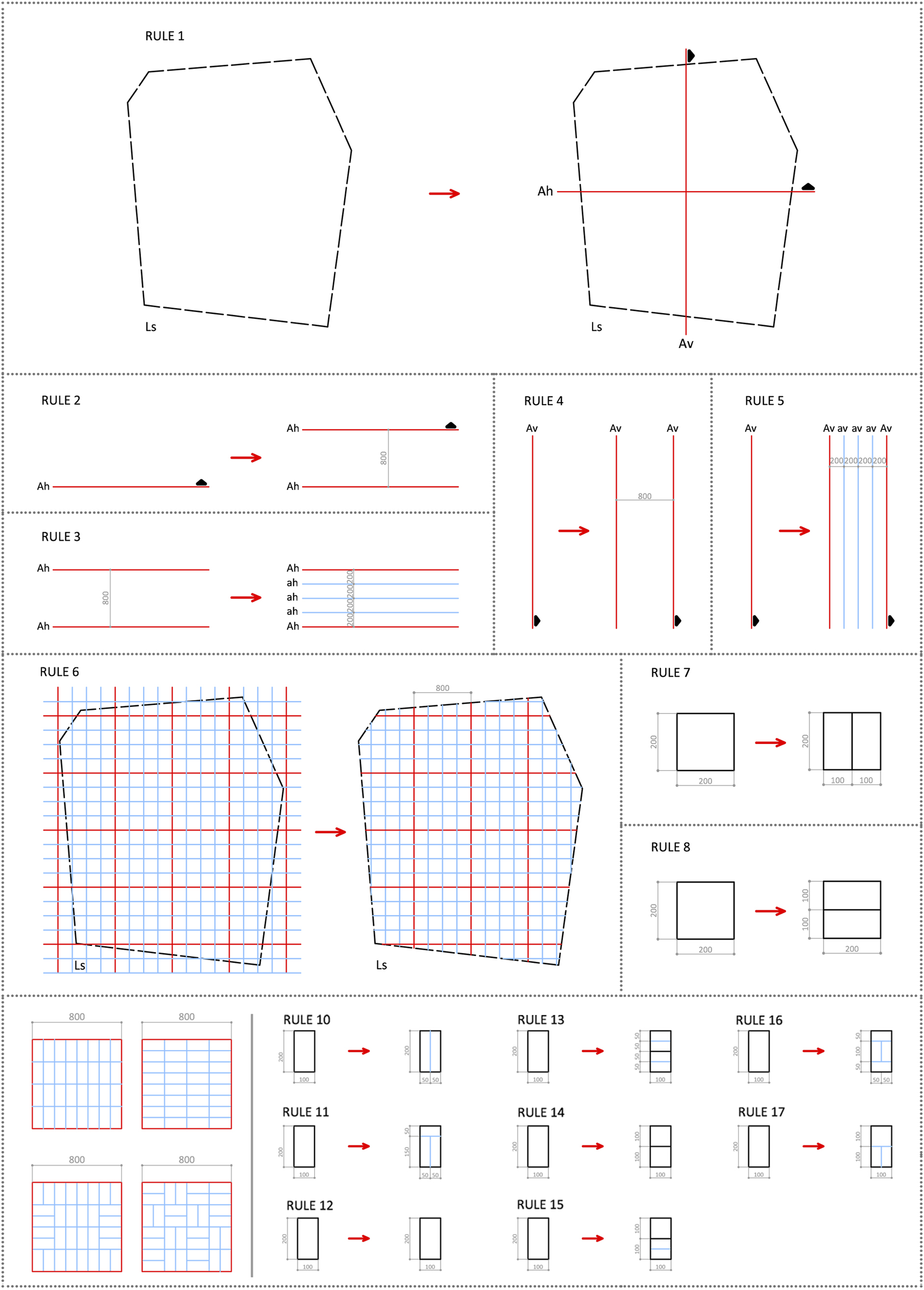
Fitness functions for fabric design: Physical Proximity Index and estimated infrastructure cost
The framework proposed here uses two criteria to drive optimization: walkability and infrastructure cost. The concept of walkability is challenging to define or operationalize, and it depends on many factors that have been widely discussed (Dovey and Pafka, 2020; Ewing and Cervero, 2010; Forsyth et al., 2008; Gehl, 2010; Pushkarev and Zupan, 1976). Nevertheless, it is broadly accepted that pedestrian accessibility, understood here as proximity to amenities, has substantial implications for the walkability of an urban area. Thus, although it is not the only metric for measuring walkability, pedestrian accessibility is one of its most addressed urban features since the likelihood of walking trips decreases with greater distances (Sevtsuk et al., 2016).
Accordingly, a considerable body of research has estimated walkability by measuring distances to amenities, focusing on grid design and amenities positioning. Brewster et al. (2009) assessed walkability in urban developments using Walkscore (Walkscore, 2020), a distance-based indicator. Carr et al., (2011) validated WalkScore for estimating access to walkable amenities, while Nourian et al. (2015) proposed accessibility measures based on an “Easiest Path” algorithm, developing a toolkit that provides actual temporal distances between locations. Lima et al., (2016) explored algorithmic systems for generating and evaluating urban morphologies, setting the distance to amenities as a criterion. In a similar context, Dogan et al. (2020) presented a computational design toolkit to model active transportation and evaluate pedestrian accessibility to amenities and public transport, while Sevtsuk et al. (2016) assessed the pedestrian accessibility of different grid layouts. Most recently, Koohsari et al. (2021) concluded that WalkScore was positively correlated with several perceived walkable environmental attributes, and there was a medium correlation between WalkScore and overall perceived walkability.
In addition, several authors address walkability assessment through a broader perspective, taking other features into consideration. For instance, Cervero and Kockelman (1997) address density, diversity, and design and Dovey and Pafka (2020) advocate that density, mix, and pedestrian access are key factors for understanding and measuring walkability. More recently, Otsuka et al. (2021) developed an adapted version of WalkScore, including traffic noise, pedestrian casualties, road speed limits, and air quality as metrics. However, considering this preliminary study’s focus on observing the usefulness of a grammar-based approach for managing trade-offs at an urban scale, adopting a single metric (pedestrian accessibility) to estimate walkability allowed us to explore a bidimensional trade-off, providing simplicity and accuracy to our analyses. It is understood that in many design contexts, an automated multi-objective approach for several prioritized objectives would provide only a starting point for synthesizing all competing concerns.
As it relates to sustainability, adopting low carbon transportation modes such as walking and cycling is recognized as crucial in carbon demand reduction strategies (Maibach et al. 2009; Nazelle et al., 2010; Lovelace et al., 2011; Rabl and Audrey de Nazelle, 2012). In this regard, Yamagata et al. (2019) state that walkability is a key performance indicator for achieving low carbon cities, as it reduces the number of cars without losing convenience and comfort. Nevertheless, efforts toward more connected cities have often relied on allowing people to move faster (using motorized transportation) around ever-expanding urban fabrics, rather than bringing urban services closer.
This paper builds on this research thread by using the Physical Proximity Calculator, a CityMetrics tool (Lima, 2017), to assess and optimize urban fabrics walkability through pedestrian accessibility. The Physical Proximity Calculator (PPC) computes the Physical Proximity Index (PPI) on scale of 0–1 by calculating the smallest distance between two or more points of interest, considering the street network and relationship between distance and likelihood of walking instead of using other transportation. For instance, a 400 m (5 min walk) or less distance between two locations corresponds to a Physical Proximity Index (PPI) of 1. The index decreases as the distance approaches 1600 m (20 min walk) and is 0 when the distance becomes greater than 1600 m. In our experiments, which aim to estimate the pedestrian accessibility of a given fabric, we set the PPC to calculate the PPIs between each parcel’s corner to the boundary corners of the neighborhood.
In an orthogonal grid system like Chicago, the average distance between all parcels corners and the grid corners is always the same, no matter the size of the urban blocks. However, since PPI does not use distances on a linear scale above and below the stated thresholds, the average distance to the corners and the average PPI of the entire neighborhood are slightly different. Maximizing the PPI of a neighborhood means looking for arrangements that avoid distances larger than 1600 m (PPI = 0) while not further prioritizing distances smaller than 400 m (PPI = 1). Therefore, maximizing PPI as a fitness function means obtaining more homogeneous proximity values, in this case, distances to the grid’s corners within a neighborhood and providing more balanced proximity values to more blocks and people. Figure 2 illustrates the differences between each of these quantities. For instance, fabric 1 and fabric 5 show opposite PPI and standard deviation distances, meaning that the former is less balanced (less homogeneous distances to the boundary) than the latter. Thus, the main question regarding walkability in this study is where should certain rules be applied to promote more proximity-balanced fabrics? Steps for calculating the Physical Proximity Index (above). Different fabric arrangements and their respective values of streets length, average PPI, standard deviation distance for corners, and average distance to grid’s corners (center and below).
Moreover, for Chicago, the boundary corners serve as mass transit stops for buses, which tend to run along the main N-S and E-W streets, as well as elevated or subway trains in specific neighborhoods. Thus, the algorithm expresses the pedestrian accessibility of a given parcel by calculating the average physical proximity indexes of its corners. When considered an entire district, these calculations provide information about the whole urban fabric.
In theory, pedestrian accessibility to destinations should increase as street networks get denser, and the possibility of connecting basic urban needs through shorter paths improves. In this regard, Zhao et al. (2019) concluded that urban areas with orthogonal street grids and high street density have good accessibility. However, as estimated by street length, infrastructure cost proportionally increases with the density of street networks, outlining a trade-off to be addressed toward less CO2 emitting and more climate-resilient cities.
Multi-objective optimization: managing pedestrian accessibility and infrastructure cost trade-off
Multi-objective optimization (MOO) is a computational methodology that supports decision-making in the presence of trade-offs between two or more conflicting objectives. It enables the exploration of complex search spaces while managing and prioritizing multiple objectives (Brown, 2016). While it has been used extensively in aerospace engineering, mechanical engineering, and economics for decades, forms of multi-objective optimization have recently become more common in architecture and related design fields (Brown, 2019; Cichocka et al., 2017; Coello and Romero, 2003; Evins et al., 2012; Marler and Arora, 2004).
For a meaningful multi-objective optimization problem, there is no single solution that simultaneously optimizes all objective functions. In this context, optimal solutions occur when none of the objective functions can be enriched without worsening others. This kind of solution is called Pareto optimal or non-dominated, and without additional preference information or post-Pareto analysis, all Pareto optimal solutions in an optimization problem are considered to be equally viable. The set of all Pareto solutions (often presented graphically) is called the Pareto frontier, also known as the Pareto front or Pareto set. While a theoretical Pareto front exists for a design problem, optimization algorithms attempt to “find” the front through increasingly accurate approximations.
At an urban design level, Navarro-Mateu et al. (2018) and Makki et al. (2019) are among the firsts to implement MOO in the generation of urban fabrics, shedding some light on addressing conflicting objectives at this scale. However, neither work considers a grammar-based approach or walkability criteria. Lima et al. (2021) have also addressed the use of MOO for walkable urban fabrics generation, although without employing a grammar-based framework, and Feng and Peponis (2021) analyze urban grids from a cost perspective, using syntactic measures.
Although pedestrian accessibility and street lengths are not always in rivalry, Sevtsuk et al. (2016) conclude that when various dimensions for plot frontage and depth, block length, and street width are combined, smaller blocks (denser street networks) tend to generate higher pedestrian accessibility than larger blocks. Thus, we address the pedestrian accessibility versus infrastructure cost trade-off as a case study to verify the utility of a grammar-based multi-objective optimization approach. The goal is to better understand this issue and evaluate more efficient solution-finding strategies. Optimization is thus explored here as a tool for discovering potentially improved designs or even directions for further modification, rather than a deterministic approach for selecting a single, perfect solution.
Methodology
We implemented two case studies to explore our approach and generate optimal alternative fabrics for the Chicago area using a Rhinoceros/Grasshopper software environment. The aim was to find solutions that maximized the Physical Proximity Index while minimizing the street network length, using the proposed Chicago grammar.
The next step was to translate the grammar into a parametric design environment. Granadeiro et al. (2013b) note several strategies for “genetification” of shape grammars into parametric systems for optimization while still encoding all possible solutions and allowing crossover and mutation to operate (Geyer, 2008; Granadeiro et al., 2013a; Mckay and Pennington, 2006; Schnier and Gero, 1998). In this research, we created input variables based on different ID numbers, each corresponding to a Chicago rule. Additional input values were set to apply the rules with different rotations. To establish a meaningful variable structure for the optimization algorithm, we have sorted the ID numbers in ascending order according to the total street length provided by a rule. For instance, Rule 16 was assigned the highest ID, while Rule 12 was assigned the lowest. Thus, inputting higher numbers means increasing the street network density and the infrastructure cost, while inputting lower numbers means the opposite.
Considering the current availability of multi-objective optimization (MOO) tools in Grasshopper, four state-of-the-art MOO add-ons were evaluated for this research: Octopus, a tool that employs Strength Pareto Evolutionary Algorithm 2 (SPEA-2) and fast hypervolume-based many-objective optimization algorithm (HypE); Opossum, that uses Non-Dominated Sorting Genetic Algorithm II (NSGA-II) (Deb et al., 2000) and Particle Swarm algorithms; Design Space Exploration (Brown et al., 2020), which uses NSGA-II; and Wallacei X (Makki et al., 2020) that also employs NSGA-II.
Among these possibilities, we opted for NSGA-II because it prioritizes the diversity of solutions by using a crowding distance mechanism, emphasizing non-dominated solutions; requires lower computational costs; and can find a much better spread of solutions and better convergence near the Pareto front compared to SPEA (Deb et al., 2000). Although the NSGA-II algorithm is commonly used with continuous input variables, its performance has also been tested with discrete variables (Anagnostopoulos and Mamanis, 2010; Wu et al., 2017). For instance, NSGA-II has been used on problems with discrete variables to optimize power converters (Visairo et al., 2012), mechatronic systems (El-Kribi et al., 2013), and in a typical building optimization problem, improving solution quality and convergence speed (Brownlee and Wright, 2015).
Following these examples, our choice for NSGA-II relies on four primary aspects: avoiding dependence on the initial solution to convergence toward optimal solutions, decreasing the time required to run the algorithm, avoiding being stuck with suboptimal solutions, and the existence of a Rhinoceros/Grasshopper tool to implement optimization procedures. Thus, Wallacei X was the chosen tool because it uses NSGA-II in a way that was compatible with our implementation of the shape grammars in Grasshopper, which relies on the gene pool component, and its data visualization interface also provided more freedom of analysis.
Case studies
The three-stage modeling logic followed in the case studies.

Study area
McKinley Park, a southwest community of Chicago, was the neighborhood selected as study area. It is a dense suburban zone with 14,484 residents, good walkability, and good land-use diversity (Niche, 2021). Our study area consisted of an 800 × 800 m grid portion with almost all blocks aligned north-south and the following features: 7400 m of alleys, an average Physical Proximity Index of 0.645, a total of 453 street intersections, and an average parcel area of 7619 m2 (Figure 3, above). McKinley Park and the study area (above). Diagrams explaining the case study logic and their respective design space sizes (below). Source: Adapted from Google maps (above), and the authors (below).
Case study 1
The first case study applied Chicago’s urban rules in a restricted manner, with rules applied to create combinations of either east-west or north-south rows of typical blocks (100 m × 200 m). This repetition of block type emulates a situation that often occurs in the city (Figure 3, bottom-left). This case study comprised modeling stages 1–3 and encompassed a total of eight genes and 48 values, resulting in a design space of 1e6 solutions.
Case study 2
The second case study applied Chicago’s urban rules flexibly, meaning that each block could have different alley layouts, thereby expanding block arrangements configurations (Figure 3, bottom-right). This case study also comprised stages 1–3 and addressed 64 genes and 352 values, resulting in a design space of 2.2e43 solutions. While this can lead to considerable irregularity, it can generate significantly more diverse designs, potentially increasing the likelihood of obtaining designs with better performance.
Results
Case study 1 led to 50,000 solutions sorted into 173 clusters of designs with the same performance, shown in Figure 4 (above). This clustering results from the limited number of ways a row of blocks can be organized, leading to many designs sharing the same total road length. Its Pareto frontier presented 50 non-dominated solutions balancing pedestrian accessibility and street network length across eight different performance possibilities. These designs perform better than the existing fabric, out of 50,000 arrangement alternatives. For instance, solution S1-1 provided an average PPI improvement of 0.01 (0.655–0.645) compared to the existing fabric, which corresponds to a reduction of 6400 m (= 368,000–361,600 m) in the sum of all the distances between corners. This solution decreased the fabric’s total street length by 3400 m (= 18,600–15,200 m), meaning a 6.4 million US dollar cost reduction, as estimated by the American Road and Transportation Builders Association (ARTBA, 2021), and the distances between corners standard deviation in 57 m (= 372–315 m). In summary, this means it is possible to obtain a fabric with decreased infrastructure cost than the existing block while decreasing the walking distances to go through all the corners while providing more balanced proximity values to more blocks. Case study 1 results (above): All obtained solutions (50,000) are clustered into 173 performance possibilities. The Pareto frontier is distributed in 8 performance clusters. Most of the solutions perform better than the existing fabric (in magenta). Case study 2 results (below): All obtained solutions (50,000) are clustered into 1174 performance possibilities. Almost all solutions perform better than the existing fabric. Some Pareto optimal layouts examples are shown on the right.
Running NSGA-II moved designs closer to an approximate Pareto front, which the algorithm is designed to do. In this case, connecting the grammar to NSGA-II resulted in mutations that increased each objective within the existing fabric, moving “up” or “down” on the Pareto front. The number of solutions was distributed along with the design space so that the Pareto solutions that prioritize average PPI (located at the Pareto frontier right-hand side, and in red in Figure 4) occurred more frequently than solutions that more effectively balanced both objectives (Pareto frontier center) and the ones that prioritize streets length (Pareto frontier left-hand size).
Moreover, most of the solutions found through the optimization process performed better than the existing fabric, considering both objective functions. Figure 4 depicts Case 1 results, including solution clusters and examples of design solutions on the Pareto front. Pareto solutions corresponding to dots with the same color have similar street lengths but different street configurations.
Figure 4 (bottom) presents Case 2 results, also including solution clusters and design examples. The 50,000 solutions in case study 2 were grouped into 1174 performance clusters, thereby presenting more diversity than case study 1. The Pareto frontier includes 50 solutions grouped into 20 performance clusters. Almost all Case 2 solutions performed better than the existing fabric, considering both objective functions. For instance, solution S2-1 provided a PPI improvement of 0.012 (= 0.657–0.645) relatively to the existing fabric. This meant decreasing: the fabric’s total street length by 4300 m (= 18,600–14,300 m) and an 8.1-million-dollar cost reduction; the sum of all the distances between corners in 22,400 m (= 368,000–345,600 m); and the distance between corners standard deviation in 71 m (= 372–301 m). Therefore, solution S2-1 significantly decreased infrastructure cost while decreasing the total distance to go through all the corners in the fabric and allowing more balanced proximity values between blocks. Therefore, the increased design flexibility permitted in Case 2 resulted in a higher number of Pareto optimal variations and significantly better solutions when compared to Case 1.
However, both Case 1 and 2 solutions resulted in significantly fewer alleys for peripheral areas. This is due to the PPI logic, which avoids distances larger than 1600 m while not prioritizing distances smaller than 400 m. Thus, the algorithm aimed at increasing proximity to neighborhood corners located in the most distant areas, the central ones in this case.
Discussion
Our initial findings point toward several advantages of using a grammar-based optimization approach in urban design. First, our approach demonstrated promising potential in tackling trade-offs since it helped filter out meaningless solutions from the search space and discover optimal designs within the predefined language. Second, our approach enabled us to find alternative urban fabric layouts with increased pedestrian accessibility (as a proxy for walkability) and decreased infrastructure cost (as estimated by total street length).
As it is broadly assumed that the likelihood of walking trips decreases with greater distances to amenities and urban destinations, the Physical Proximity Index (PPI) assesses an essential variable in this equation—the distances from all corners to all corners within a particular area. Decreasing the average PPI means reducing the distances to all possible destinations. For instance, a 0.012 decrease in the average PPI in the case study 2 (solution 2-1) reduced by 22,400 m (or 7 h of total walk) the sum of all distances between all corners, in just a small area of 800 m by 800 m. If the same improvement was obtained for an entire neighborhood—or the whole city—the likelihood of people walking would increase even more significantly. Moreover, as an average PPI of 1 means that the sum of all distances within a given area is equal to or smaller than 400 m, an average PPI of 1 is impossible to achieve in an 800 m by 800 m area. However, small increases in these values have a significant impact on pedestrian accessibility.
In this sense, it is reasonable to consider that our studies resulted in urban fabric layouts that potentially reduce CO2 emissions while maintaining the logic and essential characteristics of Chicago’s urban fabric. Third, in both case studies, the grammar-based approach resulted in alternative scenarios that presented better performances than the existing analyzed fabric, in addition to a broader range of Pareto optimal solutions to consider for further design refinement. Moreover, in some situations, the approach resulted in bunches of optimal potential solutions, providing great flexibility for decision-making. Finally, our case studies allowed us to identify some specific rules that led to more balanced configurations and others that privileged one particular objective.
However, despite achieving meaningful findings, this study reveals some limitations. The Chicago Urban Grammar is inadequate to address irregular or non-orthogonal urban block patterns. In addition, other important features related to walkability, rather than just pedestrian accessibility, like density, mix, amenities positioning, or the number of street intersections, should be explored as objective functions. Therefore, for future work, there is a broader spectrum of possibilities for exploration. We intend to incorporate more objective functions, addressing other walkability-related metrics; increase model complexity by searching for optimal locations to insert amenities; address other trade-offs related to climate resilience; explore shape grammars for irregular urban block patterns; and test other optimization algorithms.
In brief, this work aimed to contribute to climate-resilient design approaches by exploiting the potential of coupling shape grammars and multi-objective optimization to tackle trade-offs at an urban design scale. A grammar-based optimization approach was used to find fabric layouts with increased pedestrian accessibility (as a way to estimate walkability) and decreased infrastructure cost. Since our experiments provided us with urban fabrics with maximized pedestrian accessibility while minimizing infrastructure costs, this approach can be considered an initial step toward more walkable urban fabrics.
Conclusion
This paper shows the application of a grammar-based multi-objective approach to tackle trade-offs in the generation of urban fabrics in early design. The approach was illustrated by implementing a specific grammar that codifies the guidelines for designing the Chicago urban fabric to generate more integrated and walkable areas while consuming less resources and potentially emitting less CO2.
Conceptually, in our case studies, we addressed the generation of potentially more climate-resilient urban fabrics by confronting and comparing two opposite planning paradigms. The first one, addressed in case study 1 and prevailing in Chicago’s original plan, is based on a nineteenth-century design logic and imposes a more rigid grid when using shape rules. The second one, explored in different ways in Case 2, consists of a more contemporary approach that uses the grid rules flexibly in a multi-objective optimization framework to generate new possibilities and find optimal designs. Finally, since urban planning and design is a complex endeavor, with many stakeholders and various viewpoints, coupling shape grammars with optimization can support a better understanding of the trade-offs involved, promote the dialogue among stakeholders, and help reach solutions with improved performance.
Footnotes
Acknowledgments
This study was financed in part by the Stuckeman Center for Design Computing and the Stuckeman School of Architecture and Landscape Architecture, The Pennsylvania State University, United States, and by the Brazilian Coordination of Superior Level Staff Improvement - Coordenação de Aperfeiçoamento de Pessoal de Nível Superior - Brasil (CAPES) Finance Code 001.
Declaration of conflicting interests
The author(s) declared no potential conflicts of interest with respect to the research, authorship, and/or publication of this article.
Funding
The author(s) received no financial support for the research, authorship, and/or publication of this article.
