
Abstract
China boasts a multitude of cities exhibiting distinctly spatial characteristics, leading to variations in resilience. While attention has been garnered in individual cities, comprehensive studies for the whole system are scarce. Visualising and comparing the variations of spatial resilience across cities prove valuable in understanding disparities among city systems in terms of their spatial development and resilience consequences. This research measures the evolving resilience of spatial networks in nearly all cities within mainland China under intentional attack scenarios. Chinese cities exhibit different compositions of evolutional efficiency and scale effects when attacks exacerbate. The regions detected by the dissimilar compositions of spatiotemporal resilience showcase the spatial heterogeneity of road network resilience. Road network resilience of individual cities is related to city size and urbanised levels, but uncertainty is still revealed. Forming such an individual and regional scope to scrutinise the in-depth structure of spatial resilience of many cities can aid in allocating relevant spatial policies and evaluating the structural resilience risk for given cities in subject to all others.
Road network serves as a critical infrastructure for urbanisation, ensuring connectivity and the flows between essential elements (Batty, 2005). Existing research has unveiled varying vulnerability characteristics in different spatial networks. How the road network is organised metrically and topologically is indicated as a key factor for the resilience of road networks, and a huge gap was witnessed between top-down planned and self-organised cities (Wang, 2015). Most cities are far more complex than those extreme cases, as they continue evolving in changing conditions, exhibiting differentials in resilience (Sharifi, 2019). This study measures the resilience of road networks in 337 Chinese cities in the processes of intentional attacks on the roads with ranked betweenness centrality. It then maps the resilience differentials across cities and the emergent regional structure reflected therein. By doing so, we can rank the cities by road network resilience with other valuable dimensions to filter out the cities that need additional care. Also, we can uncover the extent to which nearby cities within a large city system share a similar level of resilience on their road network and where this spatial tendency is likely to end. This acquaintance can help guide the planning for resilience augmentation for a city, a type of city, and a region of cities or can be a monitoring framework to calibrate what the future transport planning will bring.
The intentional attack is considered a standard experimental setting for all Chinese cities as it closely resembles actual risks such as terrorist attacks or natural disasters occurring at critical parts. This study measures two widely used indicators of network resilience in a dual network model, namely, efficiency (E) and largest component size (S), capturing the cumulative change of the reciprocal of the shortest paths between all pairs of road segment nodes and of the number of nodes in the biggest subgraph, respectively. In general, the larger the remaining network component is, the more abundant alternative paths it can provide for preventing a sudden loss of connectivity capability. Networks in urban reality, however, do not always conform to this expectation. (The correlation between E and S for Chinese cities is 0.5.) Networks of similar sizes connected differently demonstrate dissimilar changes in efficiency and component size during being attacked. Resilience differentials are, therefore, related to the varying characteristics of urban network structures, resulting in the boundary effects across cities and regions.
In Figure 1, we express the road network resilience characteristics of each prefecture city in a manner of concentric circles, resembling a ‘resilience eye’ where the width of inner and outer rings reflects the normalised E and S, respectively. The colour and darkness document the per capita GDP for each city showcasing the urbanisation levels. In all cities, 35% of the variation of road network resilience can be explained by GDP, which yields that network densification in the urbanisation process might enhance spatial resilience. Cities in the plain with large road networks that are more easily connected exhibit higher resilience than others, such as those in Henan, Hebei, and Shandong provinces. High resilience is also witnessed in some very small cities that are prone to being developed into high-density street networks, for example, Sansha and Jiayuguan. In contrast, some economically developed cities, for example, Ordos and Fuzhou, are suffering unwarranted risks of road network fragility. To ensure a stable economy in those cities, actions for resilience improvement should be taken as a new priority. Comparing the spatial resilience rankings of cities with different socioeconomic outcomes can enhance our views of the interaction between spatial resilience and urban development and also aid in identifying cities where reinforcing resilience would be beneficial for maintaining favourable socioeconomic performance. Road network’s ‘resilience eye’ for 337 Chinese cities with normalised efficiency (inner ring) and largest component size (outer ring) under intentional attacks, plotted with the urbanised levels reflected by per capita GDP (in colour and darkness gradients).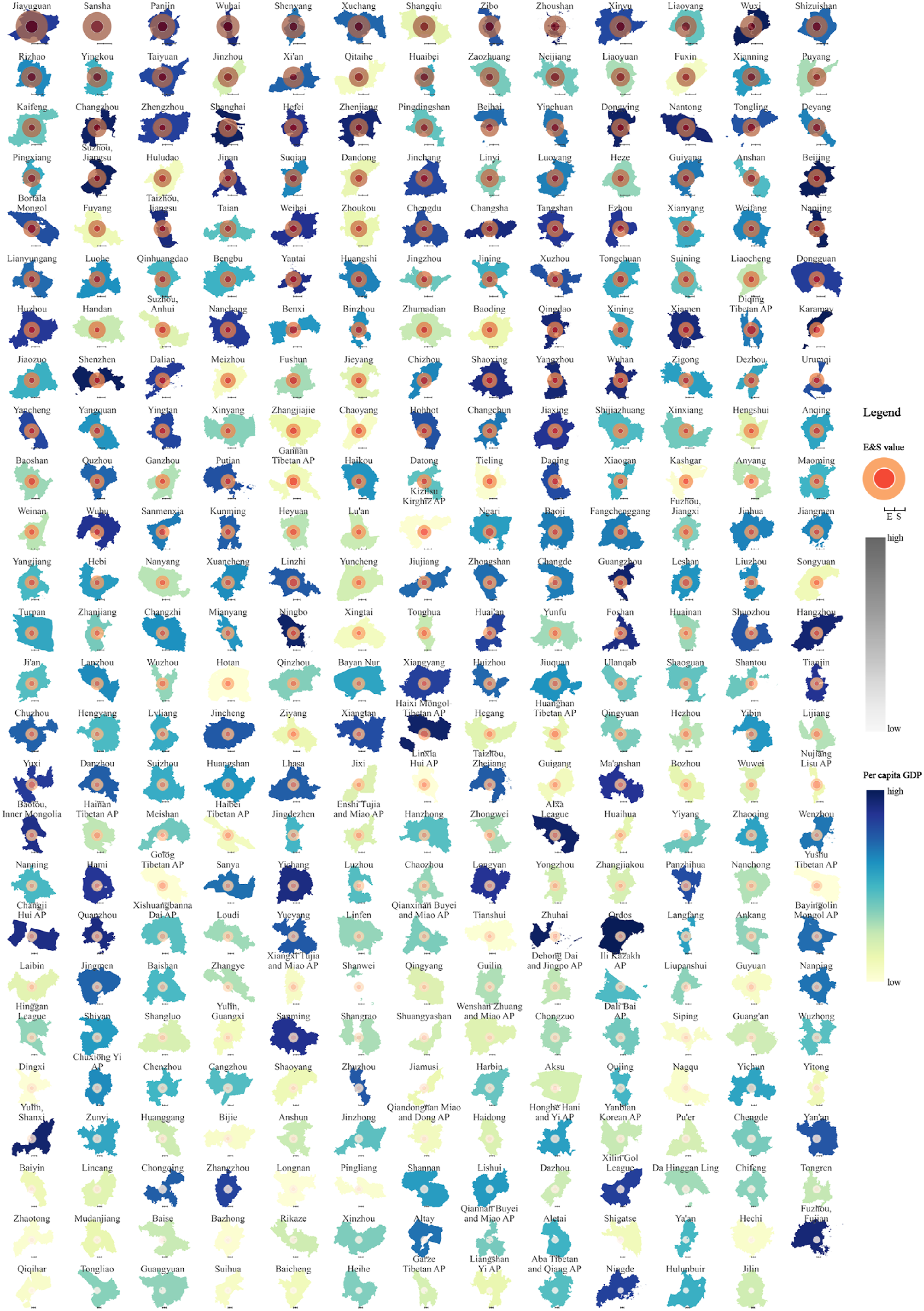
We detect the new regional structure with the similarity matrix between spatially adjacent cities indicated by the cosine similarity on the evolution of efficiency and largest component size across time until collapses happen. Twelve regions are delineated with a 0.78 modularity score and then represented with the same colour in varying darkness showing the combined effects of efficiency and scale resilience ( Resilience regional structure detected by the evolutional resilience of efficiency and largest component size under intentional attacks (colour darkness refers to the coexistence between high efficiency and large remaining biggest components).
This study measures the evolutional efficiency and scale resilience of road networks in almost all prefecture-level cities in China under intentional attacks. Investigations on individual cities show an asynchronous interrelationship between two types of resilience across cities, conditioned by network typologies, geographical settings, socioeconomic developments, etc. Chinese city systems refined by the varying spatiotemporal resilience changes demonstrate the necessity of considering the spatial localities when the planning for network resilience augmentation is implemented. Monitoring road network resilience can help to ensure proper interventions are given precisely for the associated city or region in China.
Footnotes
Declaration of conflicting interests
The author(s) declared no potential conflicts of interest with respect to the research, authorship, and/or publication of this article.
Funding
The author(s) disclosed receipt of the following financial support for the research, authorship, and/or publication of this article: This work is supported by the National Science Foundation of China (General Program) (Grant No. 52278074), the Shanghai Rising-Star Program (Grant No. 22QB1404800), and the National Science Foundation of China for Young Scholars (Grant No. 51908413).
Data Availability Statement
Data sharing is not applicable to this article as no datasets were generated or analysed during the current study.