
Abstract
Nature-based solutions (NbS) have gained popularity for their capacity to address sustainability chllenges in multiple ways. A historically grounded understanding of NbS framing in older urban areas, coupled with an examination of their resilience in contemporary times, can be very useful, especially in the global South, in the context of its urbanisation. The east Kolkata wetlands are a unique urban ecosystem for waste management and food provisioning in peri-urban Kolkata, one of India’s largest metropolitan cities. Using archival data, dating back to colonial times (mid-eighteenth century), secondary data on land use changes and in-depth interviews, we map the changes in perception and use of this wetland. By studying how food production and waste management supported by the wetland are in danger of being compromised, our research highlights why it is critical to acknowledge the multiple services of urban wetlands that are often undervalued by policymakers. We argue that if these services historically provided by the wetland are viewed as emerging NbS, they can contribute to enhancing ecosystem services, provide a better understanding of trade-offs between ecosystem services and disservices and help address sustainability challenges in today’s urban planning.
Introduction
Today, we are living in the era of urbanisation. From a global urban population comprising 30 per cent in 1950, it is estimated that by 2050, 68 per cent of the projected population will be living in cities (UNDESA, 2019). Since the 1992 Rio Declaration on Environment and Development, the sustainability challenges of urbanisation have continued to receive attention among policymakers as well as in research and academia (Sharifi, 2021). Additionally, urban ecosystems, be it natural like a river or constructed such as an urban park, have been regarded as important for addressing sustainability challenges in addition to the many ecosystem services they provide for cities and urban residents (The Economics of Ecosystems and Biodiversity (TEEB), 2011).
More recently, nature-based solutions (NbS), which are ‘solutions to societal challenges that are inspired and supported by nature’ (Raymond et al., 2017, p. 1), are being seen as the way to address multiple interlinked social and ecological problems. NbS have been defined by International Union for Conservation of Nature (IUCN) as ‘actions to protect, sustainably manage and restore natural or modified ecosystems that address societal challenges effectively and adaptively, simultaneously providing human well-being and biodiversity benefits’ (Cohen-Shacham et al., 2016, p. 2). NbS incorporate ecosystems and ecosystem services in finding a range of solutions that benefit both humans and biodiversity. This is especially significant in urban areas because it helps operationalise the concept of ecosystem services. Further, this goes beyond just recognising the services of urban ecosystems and protecting them to seeing them as part of the solution to sustainability challenges. Urban sustainability issues are complex and cannot be addressed linearly. The multiple benefits and functions of NbS can help address a range of sustainability challenges such as food production, flood control, water purification, carbon storage, heat island effect and so on. In the case of cities, especially in the global North, NbS are increasingly being seen as an urban planning tool for sustainable urban development (Dushkova & Haase, 2020). For example, among NbS, peri-urban agriculture is an important one as it reduces food miles—thereby contributing to climate change mitigation and food security—and at the same time connects people to nature, improving resource efficiency, enabling better land management and enhancing biodiversity (Artmann & Sartison, 2018). Similarly, constructed urban wetlands can simultaneously treat water pollution and provide additional benefits such as recreation and biodiversity support and provide a cost-effective and multi-functional approach in comparison to engineered infrastructure such as filtration ponds and pumps (Liquete et al., 2016; Seddon et al., 2020) while also requiring much lower investment in materials and energy (Nesshöver et al., 2017).
The concepts of NbS, ecosystem services and green infrastructure have all been introduced in the last two decades, of which NbS is the newest (Szkop, 2021). There are differences in their focus, especially their use in the urban context. Urban ecosystem services have only been in focus especially in the last 10 years (TEEB, 2011) while green infrastructure was focused primarily on aspects of urbanisation such as stormwater management or controlling urban sprawl. NbS have had an urban focus from the very start (Szkop, 2021). The greatest potential of NbS in urban planning, according to O’Sullivan et al. (2020), is that
It re-frames pre-existing terms such as Green and Blue Infrastructure (GBI) and Ecosystem Services (ES) in a way that makes principles of urban greening more understandable to lay audiences and more politically palatable for urban governments. (p. 1)
NbS is perceived as not being an alienating term because, while it is not dismissive of traditional approaches to urban planning, it is also able to integrate ecology, thus making it more acceptable across different government departments (O’Sullivan et al., 2020).
While there is now some recognition of the concept of NbS in policy and in scientific literature, there is still the need to explore linkages between NbS and ecosystem services as well as how to push for NbS to be incorporated in planning of urban landscapes (Lafortezza et al., 2018; Almenar et al., 2020). The concern is that the term ‘nature-based solutions’ is not merely relegated to being a buzzword or reduced to a green communication tool (Nesshöver et al., 2017). Further, while there has been extensive research on NbS in the past decade, Hanson et al. (2020) and Dushkova and Haase (2020) highlight a number of gaps. The geographic bias in NbS research is especially pronounced; as a concept, NbS is more established in European cities, with most research conducted in this region. A one-size-fits-all approach should be avoided, and more culturally, socially, politically and economically suitable approaches need to be adopted (Colléony & Shwartz, 2019). This necessitates a better and more context-specific understanding of local urban sustainability challenges that are amenable to NbS as well as more information on how NbS can be effective in these contexts (Sarabi et al., 2019). While environmental aspects such as flood mitigation and biodiversity support have been given greater attention, social impacts have been comparatively less studied (Sarabi et al., 2019). There is also the danger of retrofitting. Cities in the gobal South, many of which have a scarcity of funds and capacity to create built infrastructure, have relied on services provided by urban ecosystems for millennia, without explicitly labelling them as NbS (Keesstra, 2018). With the broader trend of urban sustainability discourses emanating largely from research in the global North, there is a need for more empirical research originating from the global South to help develop an understanding of NbS and interventions more relevant to the cities in the region (Dushkova & Haase, 2020; Nagendra et al., 2018).
This article attempts to address some of these gaps using the case of sustainability challenges posed by urban wastewater. Urban wastewater treatment presents a special challenge in cities of the global South. While water is vital and the use of water has increased with urbanisation, infrastructure engineered for management of wastewater such as drainage and sanitation networks or sewage treatment plants are highly inadequate and largely cater to affluent urban neighbourhoods (World Water Assessment Programme, 2017). In this article, we study the history of the wetlands situated to the east of Kolkata, one of India’s largest metropolitan cities. We begin with tracing the narratives and developments that led to the transformation of the wetland from a site of pestilence to that of productivity, along with being a site for waste management as the city urbanised from British colonial times to modern days. We then focus on the loss of wetlands post-independence owing to conversion to built spaces and examine the impacts and changing perceptions of those whose livelihoods and subsistence depend on the wetland in current times. We outline the changes to the interlinked social and ecological elements, or the regime shifts, to understand what kind of benefits accrue and hindrances are faced by the different stakeholders of the wetland, including the ecosystem itself.
By studying how the food production and waste management provided by a peri-urban wetland are in danger of being compromised, our research objective is to highlight why it is imperative to recognise these historical services of the wetland that remain undervalued by policymakers who prioritise the projected value of the converted wetland but discount its present value. We argue that these services historically provided by the wetland, if viewed as emerging NbS, can contribute to enhancing ecosystem services, provide a better understanding of trade-offs between ecosystem services and disservices and help address sustainability challenges in today’s urban planning.
Study Area
The origins of Kolkata are obscure, but the origin of the colonial city is believed to date back to 24 August 1690, when Job Charnock of the British East India Company chose Sutanuti—now Kolkata—a village on the bank of the Hooghly River, as the headquarters for the British in Bengal. The site chosen was strategic. From a military perspective, it was at a safe distance from Mughal strongholds, and lying between the Hooghly River on the west and the salt water marshes to the east, it was also protected. Further, planned as a trade settlement with a port, its riverine location provided convenient access to the sea (Sen, 2019).
Today, Kolkata is the capital of the state of West Bengal, situated in eastern India. The East India Company in 1710 occupied a land area of 6.8 km2 with an estimated population of 12,000; the density of population was thus seven persons for 0.004 km2 (4,000 m2) (Hamilton, 1744; Ray, 1902, p. 60). Today, the metropolitan city has a population of about 4.5 million living in an area extending across 185 km2, with a population density of 24,306 persons per km2 (Directorate of Census Operations, West Bengal, 2011). The wetlands, situated to the east of Kolkata, fall within the adjacent South 24 Parganas district, the largest and the second most populous district in West Bengal. The more densely populated parts are situated in the north and north-west of the district (Directorate of Census Operations, South Twenty Four Parganas, 2011). Of the peri-urban wetlands to the east of Kolkata city, an area of 125 km2 is officially demarcated as the East Kolkata Wetlands (EKW), and governed by the East Kolkata Wetlands Management Authority (EKWMA). The EKW was also designated a Ramsar site in 2002, but the wetland landscape, the mosaic of land and water, extends beyond the EKW boundary. In this article, we have used ‘EKW’ to refer to the officially demarcated area, and ‘east Kolkata wetlands’ to refer to the EKW and the extended wetland around.
Our study sites were in the northern part of this district in the Baruipur sub-division in the community development blocks of Bhangar I, Bhangar II and Sonarpur. Our study areas included the mouzas (areas of land in West Bengal having one or more hamlets) of Baghabanpur, Deara, Hadia, Kharki, Kheyadah, Khodhati and Tardah Kapashati, located within the boundary of the wetlands protected under the Ramsar Convention, as well as in two mouzas, Dihi and Tardah, that are just outside the designated boundary of the EKW. The study area is located in a landscape interspersed with water bodies, canals, agricultural fields, roads and settlements.
Methods
We used a mixed methods approach for this research. First, we conducted extensive archival research, accessing archival collections housed in the Directorate of State Archives, West Bengal, and the National Library of India (both located in Kolkata) along with collections from the Internet Archive repository (
We also accessed government documents from the National Library of India, Kolkata pertaining to the wetlands and the drainage and sanitation of Kolkata for the period 1947–2019 along with secondary data from reports on land use change. In doing this, our objective was not to undertake a comprehensive review of literature on the wetlands, but to focus on publications that looked specifically at land use changes, as this has implications for the wetland services of wastewater treatment, fishing and farming. We looked at publications that not only provided information on changes to the wetland but also on urbanisation of Kolkata, which has had implications for the wetland.
The primary research was conducted between 27 July 2019 and 2 February 2020. We conducted semi-structured interviews, lasting 35–40 minutes each, with 35 people. We selected interviewees whose livelihoods or subsistence were dependent on the wetland ecosystem in the present or past. We asked for details of their current and past employment, the processes involved in farming and fishing, changes witnessed to livelihood and wetlands over time, and cultural and subsistence relationships with the wetland landscape. We also asked them about land use changes to the wetlands, and changes in Kolkata city that had impacted the wetlands and the interviewees’ livelihoods. The interviewees included those who did farming or fishing on a small scale on their own lands, had taken lands or bheris (waterbodies where fishing is done) on lease, worked as labour in privately owned farms and bheris or were members of fishing cooperatives. We identified our interviewees by visiting their farms and bheris (those that were accessible by road), by visiting the offices of the cooperatives, and asking the owners of local businesses familiar with residents to help us locate potential interviewees. The interviews were conducted in the local markets, offices of the cooperative societies, in the farms and bheris as well as on roadsides.
For the purpose of this research, our interviewees were selected from mouzas close to the Basunti Highway (which cuts through the wetlands from west to east), keeping accessibility of interviewees in mind. The interviewees were selected randomly, but only those whose livelihoods were or are dependent on the wetlands were interviewed since the objective of this research was to understand the changing dependence and perceptions of those limited to interacting with the wetlands landscape. We have used the contemporary name ‘Kolkata’ to refer to the city that was once known as ‘Calcutta’, except when quoted directly from texts.
Results
From Pestilential to Productive: The Historical Narrative of Wetlands
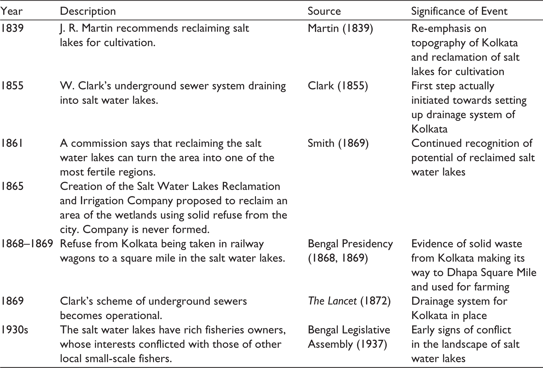
From the early eighteenth century, the British linked Kolkata city with negative perceptions of the salt water lakes to the east, referring to them as ‘the marsh and rank vegetation, producing constant and unwholesome exhalations’ (Martin, 1839, p. 13). Alexander Hamilton, writing about Job Charnock, wrote:
He could not have chosen a more unhealthy place on all the river; for three miles to the north-eastward, is a salt water lake that overflows in September and October, and then prodigious number of fish resort thither, but in November and December when the floods dissipated, those fishes are left dry, and with their putrefaction affect the air with thick stinking vapours which the north-east winds bring with them to Fort William, that they cause a yearly mortality. (Hamilton, 1744, p. 7)
This wetland needed to be drained, and an early record dated 13 January 1749 ordered the zamindar (landlord) of Kolkata city to survey the drains to ‘make the settlement sweet and wholesome’ (Long, 1869, p. 21). By the 1770s, spurred by a deadly epidemic and famine where 76,000 people died, concerns about the drainage and sanitation of Kolkata began to emerge. In 1781, Colonel Campbell proposed the cleaning and draining of the city, a proposal that was denied by the Council Board (Martin, 1839, p. 10). Yet, these concerns persisted. Governor General Lord Wellesley’s minutes, dated 16 June 1803, state:
An original error has been committed in draining the town towards the river Hooghly; and it is believed that the level of the country inclines towards the salt water lake, and consequently that the principal channel of the public drains and water-courses ought to be conducted in that direction. (Martin, 1836, p. 672)
Between the 1820s and 1850s, a number of schemes were proposed, and rejected, to drain the sewage of Kolkata and improve the sanitation of the city by linking it to the salt water lakes. Amongst these, Lieutenant Schalch’s proposal in 1821 is noteworthy, as it suggests ways to convert the narrative of pestilence into one of productivity. Schalch proposed the construction of large sewers to carry the waste from the city into the salt water lakes (Fever Committee, n.d.a, pp. xiii–xiv). He recommended raising the level of the land and clearing vegetation to enable cultivation (Fever Committee, n.d.b, pp. xvii–xxv). Captain Prinsep proposed an alternative scheme where silt from the waters of the Hooghly River could be diverted to fill up the lakes, thereby enabling cultivation (Fever Committee, 1841a, pp. 17–25). A third hastily devised scheme by Captain Thomson proposed a covered sewage system draining into the Hooghly or salt water lakes. The fourth approach, proposed by Captain Forbes, to construct an open sewage canal running 21 miles (33.8 km) through the city, was not initiated because of lack of funds (Smith, 1869, pp. 16–17). But Smith (1869) was of the opinion that such an open drain running through the city posed a health hazard, and considered it fortunate that the scheme was never taken up.
Ideas of reclamation of the salt water lakes for cultivation steadily gained popularity. F. P. Strong, a British surgeon, suggested that by draining the salt water lake, the marsh could be brought to a valuable state with profitable cultivation of crops like paddy and indigo (1837, p. 6). Indeed, the salt water lakes were already proving to be an income source. This is evidenced in the minutes of Governor General W. Bentinck, dated 2 February 1830, who noted that zamindars earned a profit from fishing, reeds and lands not submerged (Fever Committee, 1841b, p. 4).
Finally, a scheme proposed by W. Clark, Secretary to the Municipal Commissioners, was approved. The topography of the city, with its gradual slope towards the east, was used to design a sewer system that drained subsoil water, drainage from houses, including kitchens and faecal matter, waste from stables and rainwater into the salt water lakes (Clark, 1855). This was closely linked to the reclamation of the salt water lakes. A report by the commission noted that the area would ‘speedily become one of the most fertile districts in Bengal’ (Smith, 1869, p. 40).
In 1865, the Salt Water Lakes Reclamation and Irrigation Company was created, with a mandate to reclaim 115 km2 of salt water lakes and simultaneously dispose the sewage of the town in a sanitary manner. This company never saw the light of day (Smith, 1869). Yet, Clark’s scheme, using sewers to carry liquid waste to the salt water lakes, became operational towards the end of 1869 (The Lancet, 1872). Meanwhile, refuse from Kolkata was already being transported by the municipal railway line and dumped in a square mile or 2.5 km2 of land in Dhapa in the salt water lakes as part of an experimental reclamation (Bengal Presidency, 1868, 1869). The quantity of refuse dumped in Dhapa was 8,391 wagon loads in 1879 but had increased to 28,409 wagon loads by 1895–96 (Simpson, 1896, p. 23). James Fawcus, a doctor at the General Hospital, recommended the cultivation of plantain using the nightsoil collected from the dry toilets, saying it could bring in an income (Smith, 1869, p. 59).
By the end of the nineteenth century the salt water lakes provided two critical ecological services to the city of Kolkata, taking in and treating the waste of the city and generating food (via agriculture and fisheries). Some challenges for the city’s sanitation persisted. Garbage continued to be dumped in ponds and tanks in the city (The Lancet, 1889). The silting of the Bidyadhari River also affected the sewage draining into the lakes (Local Self Government Department, 1933). The salt water lakes had rich owners of fisheries, whose interests conflicted with the needs of local inhabitants involved in fishing (Bengal Legislative Assembly, 1937). These conflicts notwithstanding, the wetlands were now a receptacle for the waste of the city and a productive site for fishing. The lengthy and detailed discussions on how the city was to be drained and whether the lakes were to be reclaimed or not eventually ceased with its conversion from a site of pestilence to a place of productivity and commerce (Table 1).
Historical Timeline of Transformation of Salt Water Lakes from Pestilential to Productive.

Expanding Kolkata and Shrinking Wetlands
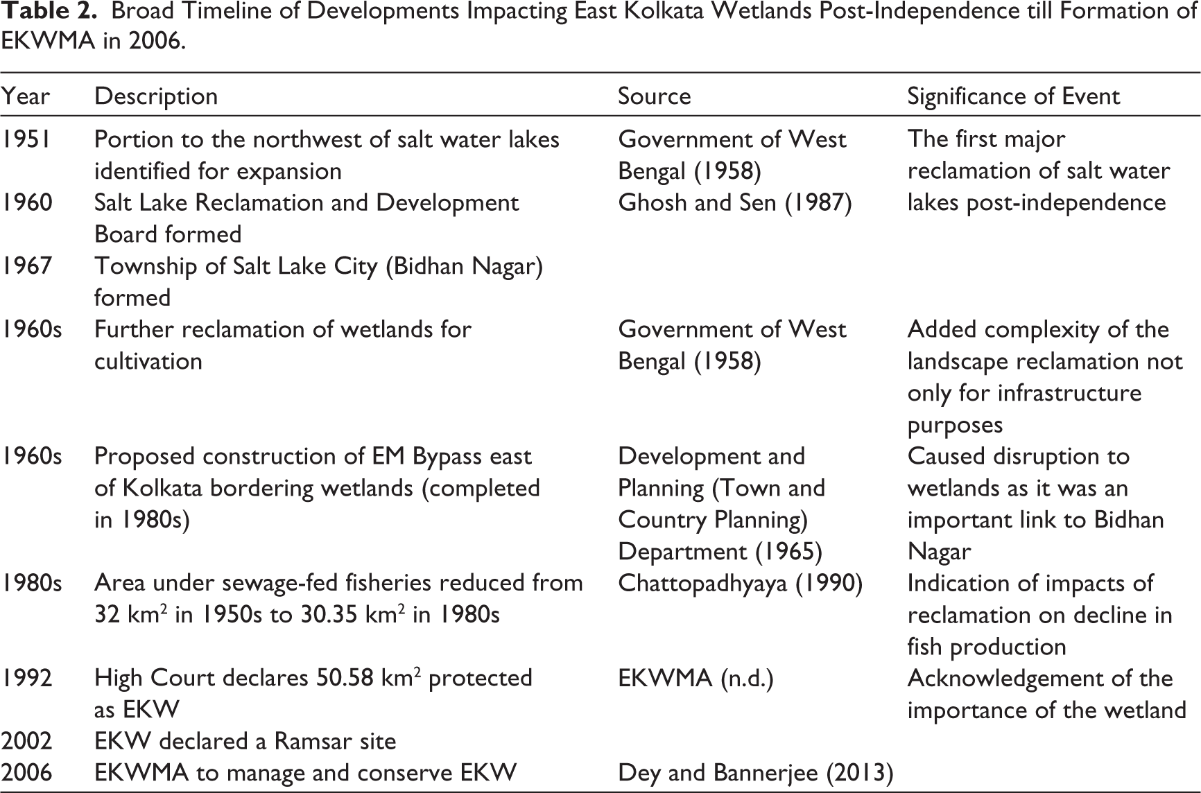
In 1933, the need for ‘further raising and filling in of the salt lakes to make room for future expansion of the city’ was presciently mentioned (Local Self Government Department, 1933, p. 9). The salt water lakes indeed regained focus in Kolkata after Indian independence. By 1951, Kolkata—with a population of 2.5 million, and an average population density of 140 persons per km2—was becoming congested. The city was hemmed in by the Hooghly River on the west and the salt water lakes to the east. The salt water lakes, identified as a source of malaria, were selected as a site for urban expansion. A report by NEDECO, a Netherlands engineering consultant, identified an area of four square miles or 10.36 km2 in the north-western part (Government of West Bengal, 1958). A Salt Lake Reclamation and Development Board was formed in 1960, and in 1967, the township of Salt Lake City (Bidhan Nagar) was formed using silt from the Hooghly River for reclamation (Ghosh & Sen, 1987).
At the same time, another proposal was planned to reclaim a further 14 square miles or 36.26 km2 of the northern part of the salt water lake for cultivation (Government of West Bengal, 1958). Cultivation and fisheries were extensive in and around these salt water lakes. Dhapa, the initial experimental site for reclamation and cultivation by the British, along with surrounding areas of Kolkata, supplied nearly 50 per cent of the vegetables needed by the city in the 1960s (Calcutta Metropolitan Planning Organisation, 1962). Sewage-based fisheries were also being carried out at the northern and southern boundary of the salt water lakes, across an area covering around 100 square miles or 259 km2. At the same time, despite urbanisation and reclamation, both fishing and cultivation received support from the government as the wetlands were recognised to be an important source of food for Kolkata (Chattopadhyaya, 1990; Ghosh & Sen, 1987).
Yet, land use changes were transforming the landscape. The decline of the Bidyadhari River and its subsequent flooding led many farmers to switch from cultivation to fishing, first in saline water and later using sewage (Chattopadhyaya, 1990; Ghosh & Sen, 1987). The salt water lakes, estimated to extend across 182 km2 in the nineteenth century, had reduced to 83 km2 by the 1950s. The construction of the Salt Lake City township (Development and Planning (Town and Country Planning) Department, 1965), followed by development of the Eastern Metropolitan (EM) bypass that took up 1.6 km2 and Anandpur Kasba township further contributed to the shrinking of the wetlands (Chattopadhyaya, 1990).
The impact of these changes on fisheries were stark. In the 1950s, fisheries covered an area of around 73 km2 and employed 12,000 people. But by the late 1980s, the area of the salt water lakes under sewage-fed fisheries was just 30.35 km2, employing 10,000 persons. The fisheries ranged from bheris of more than 2.02 km2 with collective fishing, to smaller bheris of 0.004 km2 (4,046 m2) run by individual families. Around 18.21 km2 of bheris were also brought under cultivation on the demand of farmers (Chattopadhyaya, 1990). This is interesting because this change in land use in the 1980s was brought about not only by urbanisation in the peri-urban but also shift from one kind of productive use to another.
Dhrubajyoti Ghosh, a sanitation engineer with the Government of West Bengal, termed the wetlands as the kidneys of the city of Kolkata, and fought to protect the salt water lakes (Acharya, 2018). Much credit for what remains of the wetlands today is given to him. The courts too stepped in, recognising the need to protect the wetlands. These efforts led to the declaration of 50.58 km2 of the wetland as protected—known today as the EKW—and later designated as a Ramsar site. The EKWMA was tasked under the East Kolkata Wetlands (Conservation and Management) Act, 2006 with conservation and management of the wetlands (Dey & Banerjee, 2013).
Today, sewage goes into the wetlands and solid refuse continues to be dumped in Dhapa, but the composition of this waste has moved from largely organic to toxic, leading to environmental and health concerns (Roy-Basu et al., 2020). The agriculture and fishing undertaken in the wetlands provide livelihoods to around 200,000 people and produce 18,000 million tonnes of fish, 50,000 million tonnes of vegetables and 15,000 million tonnes of paddy each year (Banerjee & Dey, 2017).The area under aquaculture extends across 58.52 km2 (which is 46.82 per cent of the EKW) while agriculture is done on 47.18 km2 (which is 37.75 per cent of the EKW) (EKWMA, 2016; EKWMA, n.d). Dhapa itself today produces 150 tonnes of vegetables and 16,000 tonnes of winter paddy for Kolkata (Roy-Basu et al., 2020). However, the urbanisation of Kolkata, expansion of housing, and construction of transport networks had shrunk the land area of the protected EKW by 26 per cent between 1973–2010 (Parihar et al., 2013; Roy-Basu et al., 2020). These changes have affected the ecosystem services provided by the wetlands to the people living in and around this landscape, as described in Table 2.
Broad Timeline of Developments Impacting East Kolkata Wetlands Post-Independence till Formation of EKWMA in 2006.
A Return to Pestilence? Ecosystem Services and Disservices of East Kolkata Wetlands
In this section, we present the range of ecosystem services and disservices of the east Kolkata wetlands. We also detail the changes to the ecosystem services as experienced and perceived by those dependent on the wetlands as well as those who reside in the landscape of the wetlands.
Provisioning Ecosystem Services and Disservices
Farming
Many interviewees had kitchen gardens, growing a variety of vegetables for home consumption, and occasionally for sale. Foraging wild plants and snails for household use and sale was also practiced in the past. These kitchen gardens consisted of tiny strips and some larger plots around the house. However, most farming in the study area was commercial. Farmers used their judgement, and the changing availability of fresh and sewage water to determine the best mix for cultivation. The farming land was owned by some of the interviewees, while others had leased land for cultivation either partially or wholly. Daily wage labourers were also employed to work in agricultural fields. Rice was the main crop, but a variety of seasonal vegetables were also grown: cucumber, ridge gourd, snake gourd, beans, ladyfinger, potato, tomato, chilly, cabbage, cauliflower, brinjal, radish and leafy vegetables. Freshwater farming was dependent on rainfall, and conducted in the monsoon. Sewage water farming was done during the drier summer months.
Paddy Cultivation while on the Decline is Still Practiced Using a Mix of Sewage and Freshwater. (Photo credit: Abhiri Sanfui).
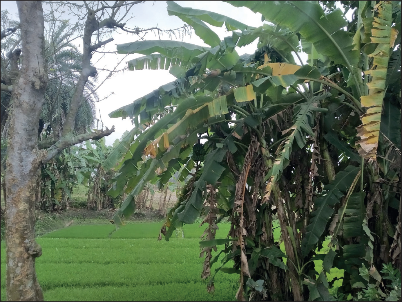
As one farmer said, ‘Sewage water is a bonus for us’. It enabled them to raise a second crop, without the additional application of fertiliser or organic compost. Almost all the interviewees felt that yield was higher in sewage water farming. But decontamination, making the sewage water suitable for farming and preventing attack from insects, chemicals and pesticides were required, which increased production costs. Yet, many farms had been converted to bheris or sold for real estate. Farming was no longer as lucrative as it was five years before the study period, even with two crop growing seasons. Some of the interviewees had discontinued farming and taken up daily wage labour but had leased out their lands on a five-year basis to other farmers. Water scarcity of both freshwater (due to the scarcity of rainfall) and sewage water (because of siltation of canals and the increase in the number of bheris) were the major reasons to discontinue farming. Farmers increasingly resorted to using water pumps to fill fields with sewage and freshwater. Canals, according to one of the interviewees, were also deliberately blocked or diverted due to political interference, enabling the diversion of sewage water to specific locations and supporting the reclamation of more land to buildings.
Soil fertility had also reduced with soil turning saline. Farmers indicated that the quality of sewage has changed over time. In the words of one interviewee, the sewage today makes the crops ‘soft and weak’. Insect pest attacks have also become more common. One farmer pointed to changes in seed quality, with the new seeds being high yielding, but not as resilient to variability in soil moisture and water content.
Sewage-based fishing
Sewage-based fishing was done by individuals in small bheris that they owned or leased, either as members of cooperatives, or as fishers employed in larger privately owned bheris. They regulated the quantity and quality of sewage to ensure that the fish grow quickly and to very large sizes. First, the bheri was drained, and then ploughed. Sewage water was transferred to the bheri from the canals, often using an electric pump. Lime was added to clean the water, followed by the addition of husks of mustard and oilcake made from seeds of Madhuca longifolia (an Indian tropical tree). These provided food for the fishes and purified the water. After 15 days of treatment, fingerlings and fish eggs, either bred in a bheri owned by the fishers or bought from the market, were added to the water. Fishers had detailed knowledge of the locations in the bheri preferred by different species of fish, and their relative tolerance to the extent of sewage in the water.
When the quantity of sewage was high, the water required greater additions of husk and sometimes, compost from cow dung, driving up input costs. In the rainy season, more fish food was needed to be added because the sewage was too diluted. Fishers also purchased and added food waste from hotels, ensuring that the food was not too oily, as excess oil in the water was harmful for the fishes. Waste from meat shops was also added as food. Thus, this is a coevolved case of fish cultivation in urban surroundings. Explaining the need for different kinds of fish food, one of the interviewees said, ‘Just like us humans, who eat a variety of food everyday like lentils, rice, vegetable curry, fish curry, chicken curry, fishes too demand variety in their diet’.
Bheris with an Optimal Mix of Sewage and Freshwater for Fish Production (Photo credit: Seema Mundoli).

Fishes are more prone to disease during the winter season. Hence the harvest of fish was done before winter in the rainy season, and smaller bheris were then drained of their water. Fish diseases were treated using home remedies as well as medicines purchased from the market. Bheris that have a very bad infection of disease may need to be drained and refilled, but this is difficult for very large bheris. While small bheris may be drained once in two years, large bheris, like those owned by cooperatives, are emptied once in 10–15 years. These large bheris especially needed to be guarded against fish diseases. Interviewees also faced challenges of fish theft and the diversion of sewage water and fish via channels from one bheri to another, often towards larger bheris, which the interviewees said were owned by those with more political clout.
Canals Clogged with Garbage Resulting in Toxicity of Water and Reduction in Flow of Water to Bheris. (Photo credit: Seema Mundoli).
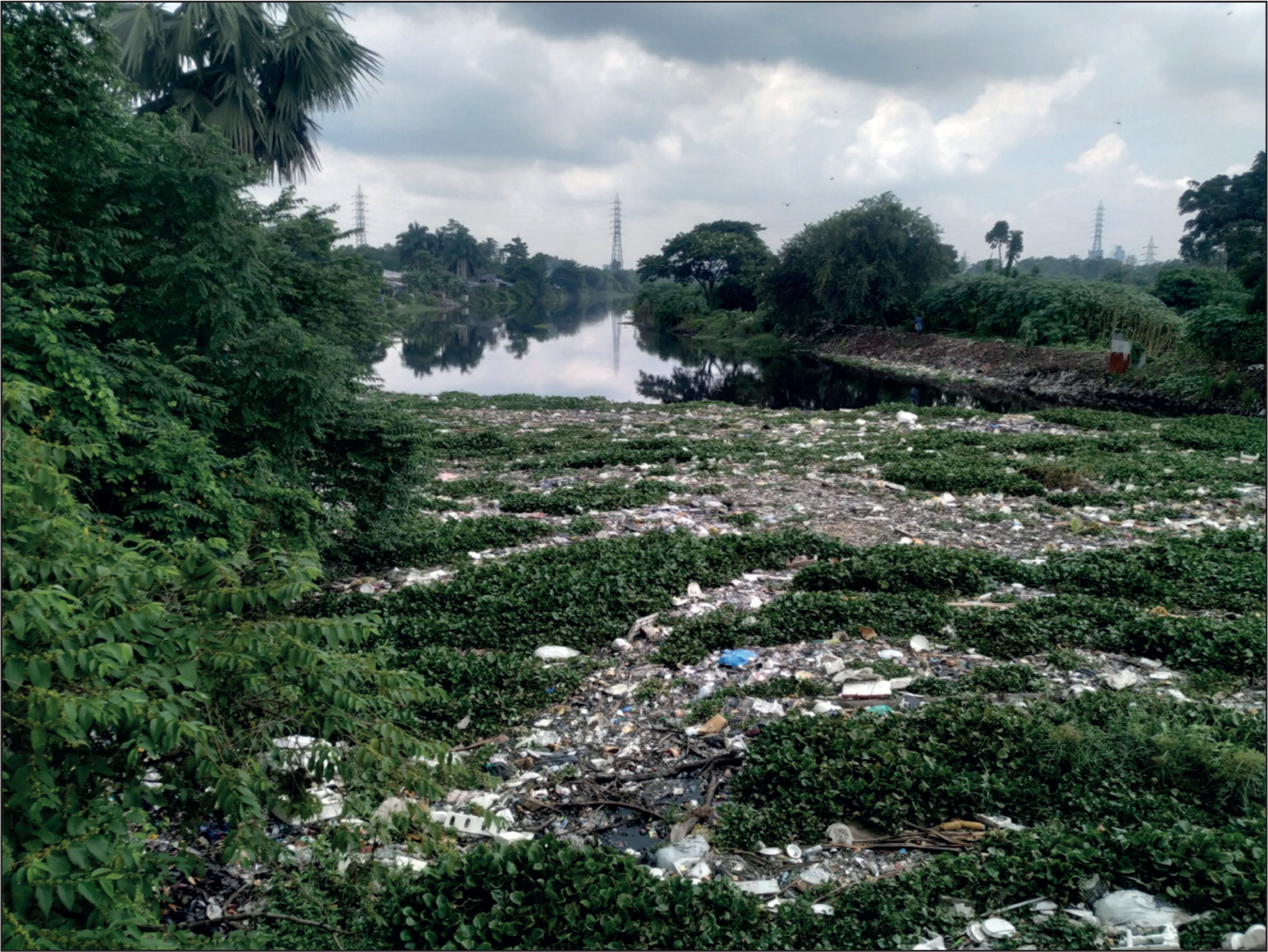
Overall, like farming, fishing too has become more difficult in recent times. Fishing requires access to an optimal mix of freshwater and sewage. Access to sewage water is determined by the location. Outside the EKW boundary, fishing using sewage water was difficult as the canals were at a considerable distance. If there was not enough sewage water, then the water needed to be supplemented with fish food, increasing costs. According to one interviewee,
Earlier Kolkata had many cattle sheds which used to produce a large amount of cow dung. This cow dung was then dumped into the canals which were connected to the bheris. So, the fisheries used to get sufficient food from the cow dung. But number of cow sheds in the city has reduced drastically.
Our interviews with members of fish cooperatives, which supported several fishers, indicated a decrease in productivity and income. Coupled with a lack of government support, this led to many fishers needing to supplement their incomes via wage labour in construction, farming or fishing. Increasing toxicity of the sewage water, especially during the Hindu festival of Holi due to the toxic colours used in the festival, also impacted productivity. Some interviewees had reduced consumption of fish from the wetland because of the poor quality of fish. There were also changes in fish species. The grass carp, which feeds on hyacinth growing on the edge of the bheris, has reduced in number as some bheris have removed the hyacinth to create more space to cultivate other species. The introduction of exotic species such as magur (Clarias batrachus) and tengra (Mystus vittatus) makes the bheri unsuitable for other fish as these varieties require protein rich meat waste from butcher shops.
Cultural Ecosystem Services and Disservices
The landscape, with its mix of land and water, provided an ideal site for shooting films and television serials. Larger bheris were also rented out for shooting. One of the interviewees, a fisher and manager of a cooperative, said that renting for shooting serials had started in their cooperative around seven years ago. At present, they charged ₹5,000 per day for the shooting and if they were lucky, they could get about 15–20 days of shooting in a month, adding to the cooperative’s income. Some cooperatives allowed shooting throughout the week, but others restricted it to weekends. Near one of our interview sites, a television crew had built a makeshift temple, but in the process had left the place strewn with all kinds of litter.
Large groups and small families also come for picnics to the bheris during winter. One of the cooperatives we visited even had a children’s play area with swings and slides. But while this provided an income, it brought with it its own share of worries, including garbage and sometimes dealing with drunk and violent city visitors, as one of the managers of a large bheri explained.
In addition to bheris, the landscape also had small ponds locally known as pukur. These ponds were community spaces where old and young men and women, gathered for conversation, sometimes talking for hours. Some ponds were used for bathing, while others were considered sacred. One sacred pond had cemented sides and steps, and a small temple at the top of the steps. Under a sacred peepul (Ficus religiosa) tree, on a square space on the ground, an idol of Goddess Durga was placed during the Hindu festival of Durgotsava, with the idol later immersed in the pond. Meat waste was not added to sacred ponds, so as not to defile them. During the monsoon, fishers went to the dargah (last resting place) of a local religious leader, Pir Mobarak Gazi at Ghutiari Shariff. This dargah was visited by devotees from both Hindu and Islamic faiths. A saffron flag sprinkled with holy water from the dargah was tied to a pole and stuck in the mud, to safeguard the bheri.
Regulating and Supporting Ecosystem Services and Disservices
During field visits, we noted the presence of a number of new houses and shops being built in former farms and bheris. A crisscrossing network of roads cut through the landscape, according to the interviewees, a mixed consequence of the voluntary sale of lands, lands taken by force by local land mafia without any compensation and encroachments. Interviewees stated that water levels in tube wells had fallen in villages, and temperatures had increased. A diversity of native and exotic species of fish were bred in the bheris, including Indian carp species such as catla (Catla catla), rohu (Labeo rohita), mrigal (Cirrhinus mrigala), bata (Labeo bata) and calbasu (Labeo calbasu) and exotic carp species such as silver carp (Hypopthalmichthys molitrix), grass carp (Ctenophayngodon idella), tilapia (Tilapia mossambica) and Nyclotica (Oreochromis niloticus). The population of jackals, crabs, turtles and snakes seems to have reduced drastically over the last 7–8 years. According to the farmers in the landscape, the biodiversity loss was linked to changed farming practices and the overuse of fertilisers had led to loss of soil fertility.
Discussion and Conclusion
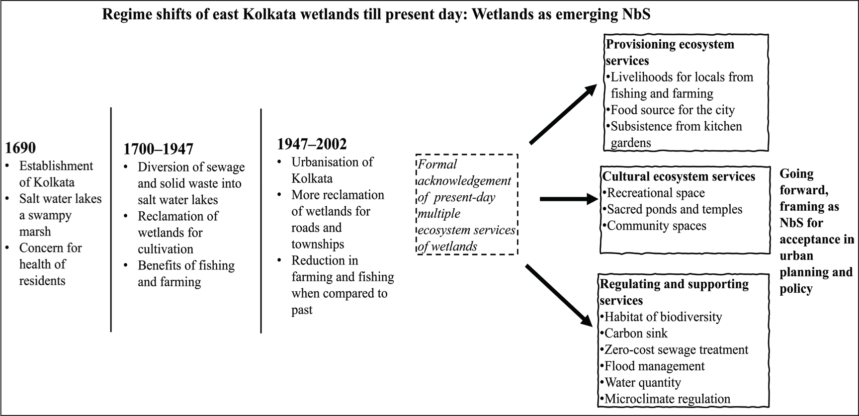
The EKW and the wetlands beyond its boundary provide a range of ecosystem services. Farming and fishing supply food and contribute to direct incomes as well as indirectly through wage labour done on farms and bheris and other employment associated with farming and fishing. Poultry farming and animal husbandry are also supported by the wetlands (EKWMA, 2016; Kundu & Chakraborty, 2017). This research did not look too deeply into the cooperative fisheries since examining the functioning of the cooperatives in detail was not part of the research focus. But fisheries owned by the State Fisheries Development Corporation and cooperative fisheries also support fishers and add to fish production; cooperatives can earn ₹10 million a year selling around 7 million tonnes of fish (Chakraborty & Das Gupta, 2019). The wetlands also function as a free sewage treatment plant for Kolkata, subsidising the city that would otherwise have to pay to treat its sewage. Around 78 per cent of the sewage generated by the city of Kolkata, the annual cost of treating which is estimated at $100 million, is treated by the wetland (Banerjee & Dey, 2017; Dey & Banerjee, 2018). The stormwater drains, channels that run alongside the sewage channels, take in the excess water during rain and prevent flooding in the city and in the surroundings. Wetlands in Kolkata help reduce the urban heat island effect, helping in temperature regulation (Bera et al., 2021) and the east Kolkata wetlands contributes to this as well. The wetlands also act as carbon sinks, removing carbon dioxide from the atmosphere and serve as the lungs of the city, cleaning the air of pollutants (Roy-Basu et al., 2020). The biodiversity documented in the wetlands includes plants, mammals, birds, fish, reptiles and amphibians as well as insect and mollusc species (Mallick, 2009). In addition, the wetlands also support cultural services. The transformations since colonial times have resulted in regime shifts of the social and ecological aspects of the wetlands, but the range of ecosystem services are critical for the local residents as well as the city as a whole (Figure 4).
Regime Shifts of the East Kolkata Wetlands.
The east Kolkata wetlands may never have been classified thus, but can be called emerging NbS in the global South since historical times because of the multiple benefits that they provide and their continuing role addressing sustainability challenges of cities today such as waste management. The salt water lakes adjacent to which the British chose to set up their first imperial capital, Kolkata, were initially a site of pestilence and disease for the city and its people. The British efforts at making the salt water lakes a receptacle for the waste of the city and reclaiming the land for cultivation using sewage turned this marsh into a productive site for agriculture and fishery that continues to the present day.
A recognition of these multiple ecosystem services of the east Kolkata wetlands is much needed in urban planning and policy, especially as an example of emerging NbS to address sustainability challenges faced by Indian cities and other cities in the global South. There needs to be an acknowledgement of the role of these wetlands in contributing to societal changes across scales, from the individual to the city. The wetlands are a cost-effective and resource-efficient way to deal with waste and create wealth out of waste; it is not technology-centric but ecosystem-centric. The east Kolkata wetlands address much more than a specific problem—from being an income source for individuals, to supplying food to a city, conserving biodiversity and as an ecosystem having the potential to mitigate the impacts of climate change. As NbS, they are not only a resource recovery system but also restore critical natural processes (Nika et al., 2020) such as removing pollutants and recharging groundwater.
NbS today emphasise equity and leveraging of local knowledge (Cohen-Shacham et al., 2016). This acknowledgement of equity and traditional knowledge is an opportunity in countries of the global South such as India to enable local communities, who have depended on urban ecosystems and have protected them, to be recognised as partners in addressing urban sustainability challenges. The farming and fishing practices in the wetlands may have been introduced during colonial times in the late nineteenth century, but it is the generations of fishing and farming households who through their practices have adapted and ensured the continuance of this knowledge. The wetlands thus are repositories of local knowledge and their conservation, and with careful restoration can enhance the livelihood opportunities for local communities who are at present struggling to make ends meet (Nesshöver et al., 2017).
We are not suggesting that recognising the wetlands as NbS will provide a panacea for urban sustainability challenges, as there are many limitations primarily around trade-offs and ecosystem disservices too that have to be considered. The need for land as the city urbanises further will put pressure on the wetlands. This is already happening, as we observed in our field visits, with the conversion of farmlands. In the absence of wetlands receiving acknowledgment in urban planning as a source of food, in the future, more of the wetland could be converted to prioritise urban uses, especially since only 125 km2 has legal protection. This can have multiple effects not only just for those who depend on it for their livelihoods but also the biodiversity and ecological functions provided. The mosaic of land and water (both fresh and sewage) that comprises the wetlands is the most crucial factor on which ecosystem services depend. It is also the changes to the landscape that will determine how successfully the wetlands will continue to perform the ecosystem services so critical for the city of Kolkata. The urban growth, especially within the wetland, has been described as an infestation that is compromising the wetlands’ many ecosystem services (Dey & Banerjee, 2013, 2016). Changes to land use also bring about changes to livelihood options, with the younger generation especially shifting away to other kinds of work, further leading to a loss in the transfer of local knowledge systems in fishing and farming (Roy-Basu et al., 2020). Biodiversity too has been impacted. Diversity of birds has reduced as result of fragmentation of the wetlands (Bhattacharyya et al., 2008) and land use changes. Fish diversity has been impacted by introduction of exotic species (Hussan, 2016), while the Bengal marsh mongoose (Herpestes palustris), an endemic species, is threatened as result of land use changes and changing composition of the sewage (Mallick, 2013).
The trade-offs when it comes to land use changes are of concern because it may lead to gentrification. The wetlands cultural ecosystem services are recognised as recreational (Banerjee & Dey, 2017). The prioritisation of urban ecosystems purely for their recreational services is increasingly visible in urban planning, especially under new visions for cities such as smart cities. There is thus a danger of alienating users who have depended on these ecosystems for livelihoods and subsistence, thereby contributing to gentrification (Mundoli et al., 2017). What is especially alarming is that several such interventions are even passed off as NbS. In operationalising NbS, care has to be taken that it does not result in gentrification (Scott and Lennon, 2016), a concern especially in the highly unequal cities of the global South. At present, sewage-based farming and fishing are still sources of livelihood. The increasing toxicity of sewage composition, reduced availability of fresh water, reducing soil fertility and land use changes in the wetlands are already impacting these livelihoods and other connected activities such as wage labour and small businesses. Farming is increasingly seen as being non-lucrative, and farmers are either giving it up to take up wage labour or interestingly converting farms to bheris. But input costs for fishing are also rising because of the need to buy fish food and medicines to treat diseases in fish owing to changes in composition of sewage. If enough support is not provided to farmers and fisherfolk, there is the danger of the wetlands being increasingly perceived as a source of ecosystem disservices.
NbS is still an evolving idea, especially in the global South cities where there is limited knowledge about its multiple benefits, while at the same time many urban ecosystems have traditionally been providing multiple ecosystem services. Perhaps the greatest challenge continues to be in operationalising NbS: How can NbS contribute to more sustainable urban policy and planning, as they have in cities of the global North? Making NbS more acceptable and enabling their operationalisation will require a context-specific understanding of the interactions of urban ecosystems especially between ecosystem services, trade-offs and disservices. We find through our study that the east Kolkata wetlands, with its multiple ecosystem services, has the potential to be classified as low-cost, effective and equitable emerging NbS for addressing multiple sustainability challenges of water scarcity, waste management, food supply and livelihoods, in addition to numerous other ecosystem services. We argue that cities in the global South, including India, where the poor continue to depend on urban ecosystems, NbS can provide a way to address the challenges of both sustainability and equity. For this, the urban ecosystem should not be seen as real estate or token spaces to meet ‘green’ targets of cities, but as emerging NbS providing multiple benefits.
Footnotes
Acknowledgements
We would like to express our gratitude to all the interviewees for giving their time and sharing the information. We also thank the staff at the Directorate of State Archives and the National Library of India, Kolkata, for their assistance in accessing the collections of historical documents. We would like to thank the anonymous reviewers for their detailed comments as well.
Declaration of Conflicting Interests
The authors declared no potential conflicts of interest with respect to the research, authorship and/or publication of this article.
Funding
The authors received financial support for this research from Azim Premji University for the publication of this article.