
Abstract
Srinagar, an ancient city, is well known for its heritage wealth with more than 1,200 years of urban history established in the region by passing through the greatest kingdoms in the past. Globally, due to many challenges, such as extreme urbanization, rapid population growth and climate change crisis, the urban heritage buildings, monuments and sites are subject to degradation and extinction over time. The present study intends to identify and evaluate the heritage sites located in the Srinagar city and assess their spatial and structural vulnerabilities. An extensive field survey was conducted by which 20 structural heritage sites dating back to the 1800s and before has been identified for evaluation. Vulnerability analysis of sites was done based on seven selected parameters fabricated within the 300-metre buffer zones in the geographic information system (GIS) environment. An insight into conservation strategies and planning measures and challenges in the disaster risk reduction of heritage resources have been portrayed in the study. The results show that the Srinagar city has significant heritage structures with beautiful architecture that is now in a dilapidated and deserted condition with limited implication of the conservation strategies and less involvement of the stakeholders. The results indicate a dire need for sustainable conservation measures incorporated for disaster risk reduction of the urban heritage. The study holds great significance for the decision-makers in policy development and planning, especially for the management of the sites.
Introduction
Every community has its unique history of culture and inheritance preserved in the form of ecological and cultural heritage (UNESCO, 2008). Cities, towns and countries all have places, sites and structures that hold a distinctive identity and bear witness to their stages of evolution (Talukdar, 2010). An umbrella term ‘cultural heritage’ includes natural and man-made legacy (Szmelter, 2013). In line with the United Nations Educational, Scientific and Cultural Organization (UNESCO) convention concerning the protection of the World Cultural and Natural Heritage, there is a general acknowledgement that heritage needs to be identified, documented and conserved properly (UNESCO, 1972).
India, known for its rich cultural and historical heritage, is scattered with abundant specimens that tell tales of age-old civilizations, great empires, splendid architecture, sociocultural evolution, diverse religions, art and literature. India’s history of political, social, religious and regional conflicts has taken a toll on the monuments and structures (Menon, 2014). Srinagar, the largest city of Jammu and Kashmir, located in a fragile environment in the lap of the western Himalayas, is a high to very high seismic risk zone and prone to flood hazards (Anees et al., 2015; Bukhari et al., 2016). The drastically evolving urban centre, the political unrest, and the ever-increasing population threaten the heritage treasure, by either endangering the knowledge or destroying the structures and sites (Khan et al., 2015; Recchia, 2019). Therefore, documentation of the archives, conservation and maintenance of the ancient cultural heritage are a challenging task at the hands of government and researchers to attenuate the risk of losing heritage or serve as the basis for reconstruction (Allchin et al., 1989).
The study presented in this article tries to identify and evaluate 20 selected sites located in the Srinagar city dating back to the 1800s for spatial and structural vulnerability assessment. The analysis is supported by multilevel indicators to review and assess the existing conservation strategies and facilitate informed decision-making in the future. Our approach widens the perspective of city growth by focusing on preserving the historic–cultural heritage resources recognized as an element for sustainable development and ensuring their maximum possible vitality, values and functions to the benefit of current and future generations.
Identification and Evaluation of Urban Heritage Sites of Srinagar City
The Kashmir valley has a rugged topography, steep slopes and distinct geology and climate, which is susceptible to multiple hazards (Ahmad et al., 2021; Alam et al., 2015; Bhat et al., 2018; Shah et al., 2021). Srinagar is the only city in the valley with a high population that has encountered disastrous hazards historically (Alam et al., 2018; Ali et al., 2021). The rapid growth of the city has degraded the environment and changed the ecological setting of the region. The population has increased from 0.122 million people in 1901 to 1.225 million people in 2011, revealing a nearly tenfold increase that accounts for 900% growth with a net increase of 1.103 million people (Amin et al., 2012; Kuchay et al., 2016). The heritage character of the city is under threat by growing human interferences and official negligence (Alkazi, 2014).
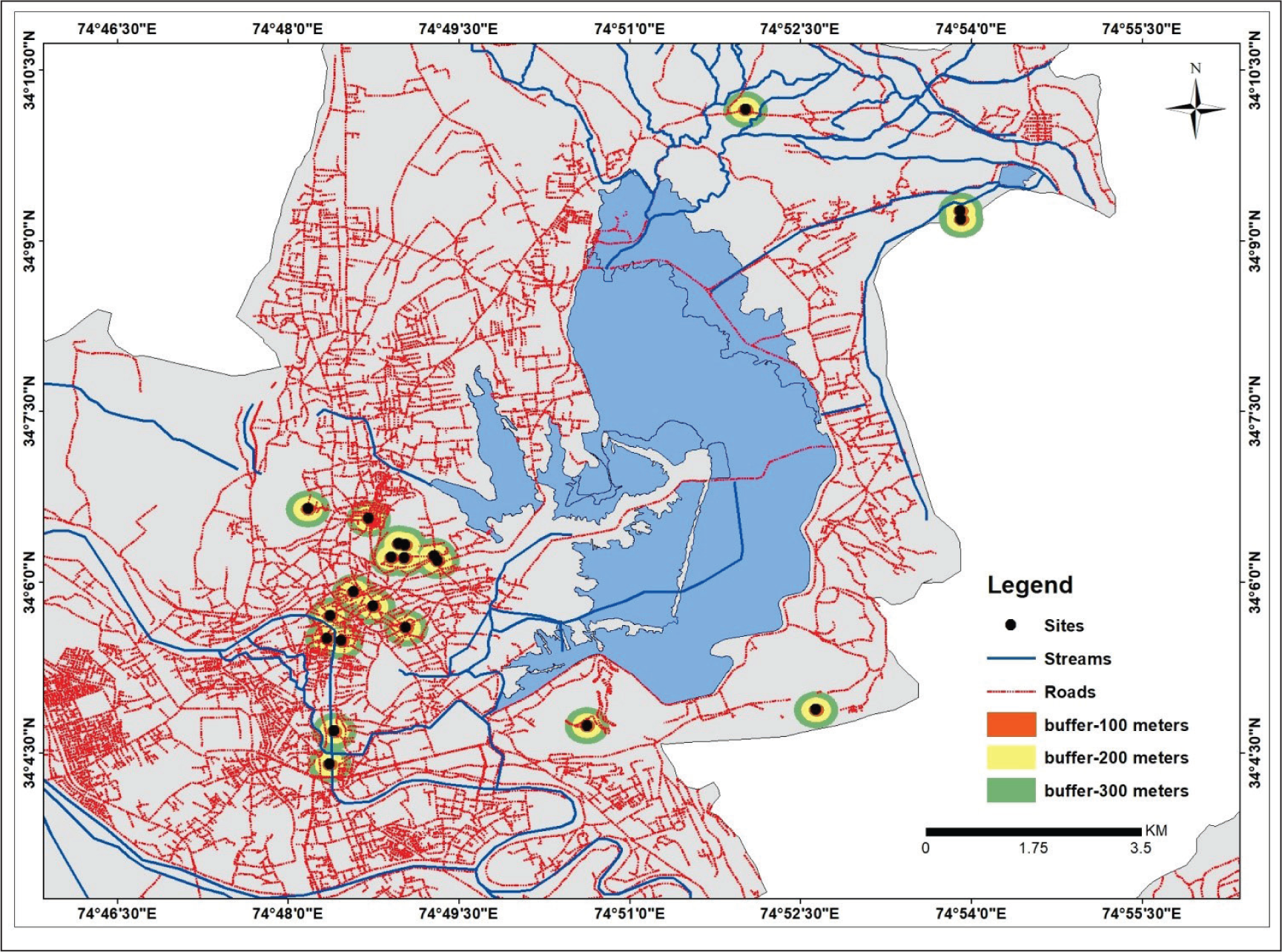
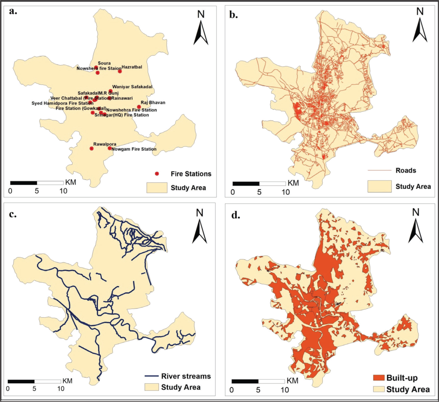
The conservation and improvement of historic heritage areas require identification and mapping of sites, buildings and structures, and the procedure to identify the urban heritage of Srinagar city has been given a go ahead in its revised master plan of 2035. The study incorporates an extensive literature review and a spatial and structural analysis of heritage sites through field survey. A total of 20 heritage sites based on the age of the structure (i.e., dating back to the 1800s and older) were selected and their ground scenario was analyzed during the survey. The geographical coordinates of sites were recorded with the Trimble Juno GPS receiver. A location map (Figure 1) has been generated similar to the other works like Permit and Sithole (2021) and Anees et al. (2015). The buffer zones, 100 and 200 metres, respectively, were created following the survey conducted by the Archaeological Survey of India (ASI), where 100 metres is the prohibited zone, and 200 metres is the regulated zone as presented in Figure 2.
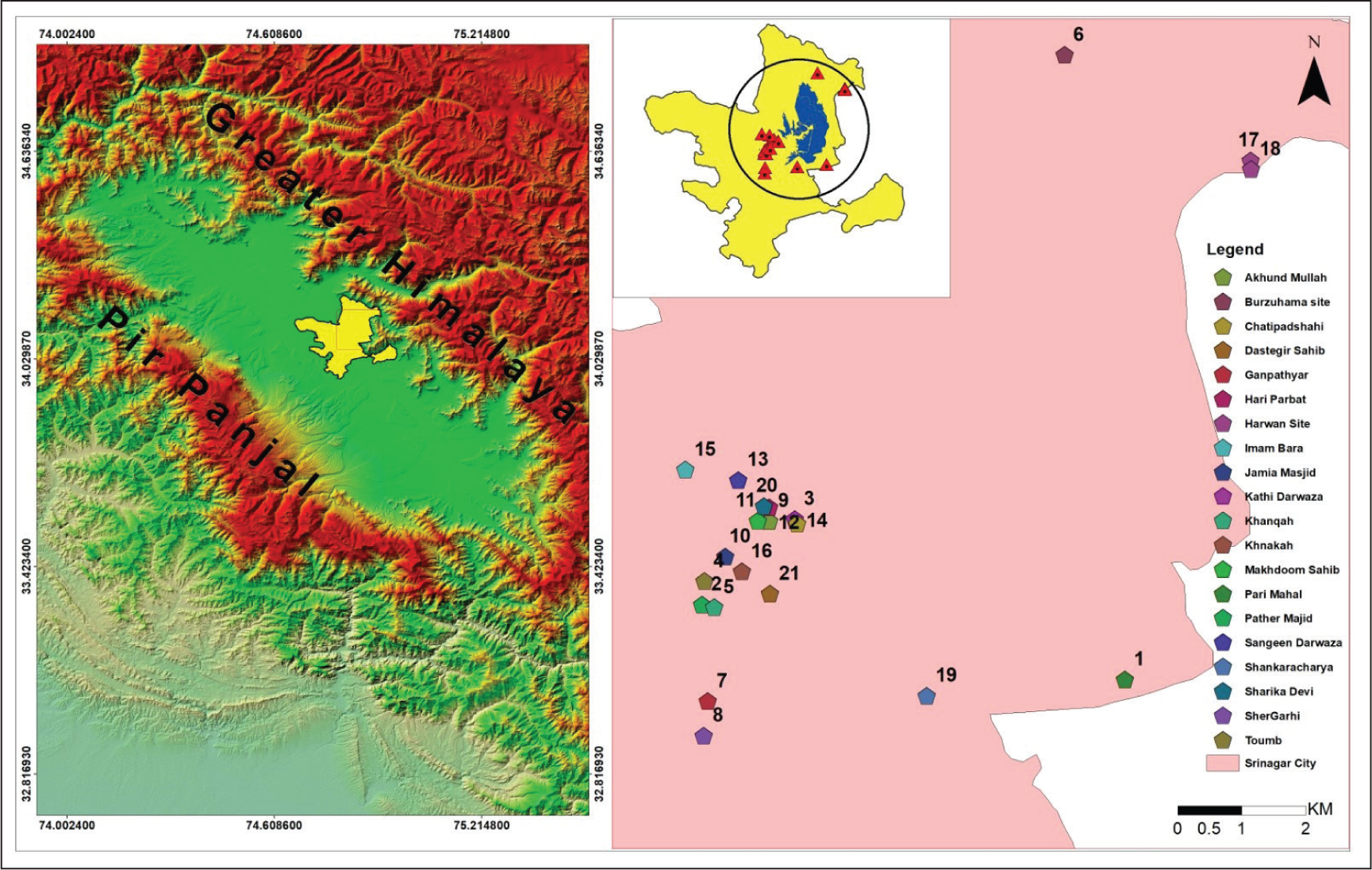
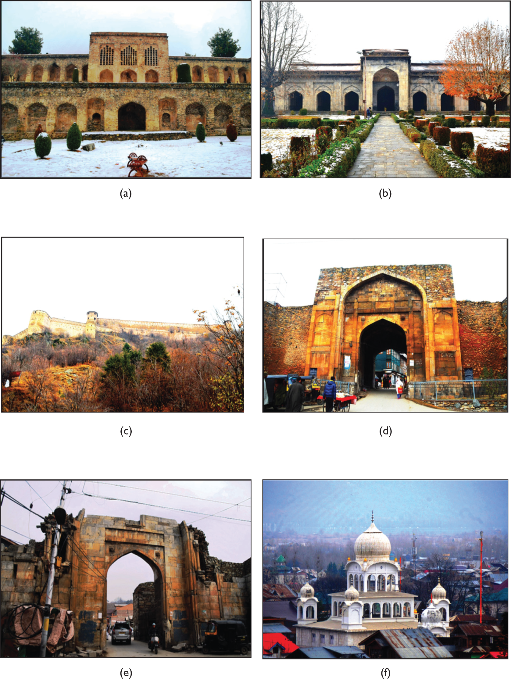
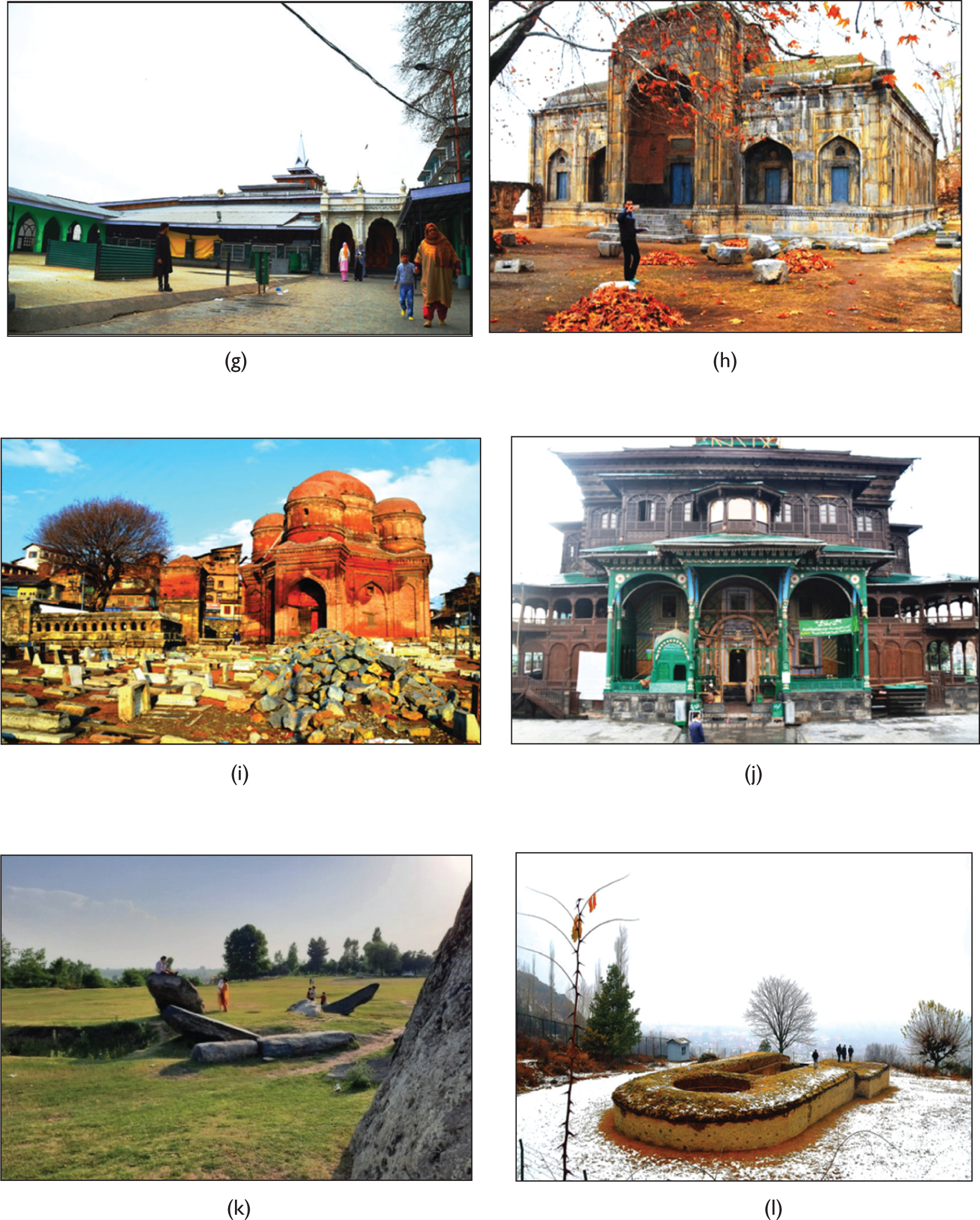
From the spatial analysis of the selected heritage sites (Figure 1 and Table 1), it was seen that majority of the sites fall within the municipal limits of the Srinagar city. The study reveals a rich and diverse cultural and historical heritage resource base such as the Mughal gardens, floating gardens, mosques, Sufi shrines, temples, gurudwaras, forts, tombs and palaces. Moreover, most of the buffer zones around heritage sites overlap and manifest an adequate number of historical structures located in the old city.
Detailed Evaluation of Heritage Sites
Geographical Location of Heritage Monuments/Sites of Srinagar City

Governance and Management of Heritage Sites
The existing regulations and governing organizations for the heritage preservation and conservation are as follows:
Conservation Strategies for Disaster Risk Reduction of Heritage Sites
Global and national conservation and management plans mainly focus on disaster risk reduction of heritage and cultural sites. Disaster management guidelines for heritage buildings are one of the proposed resolutions for protecting and conserving heritage buildings. Various international and national organizations have provided a framework for the management of the cultural heritage from a disaster aspect as follows:
UNESCO has published ‘Managing Disaster Risks for World Heritage’ in June 2010. International Centre for the study of the Preservation and Restoration of Cultural Property (ICCROM) has adopted the international charter for the conservation and restoration of monuments and sites in the II International Congress of Architects and Technicians of Historic Monuments, Venice, 1964. ICCROM published ‘A Guide to Risk Management for Cultural Heritage’ and ‘Risk Preparedness; A management manual for Cultural Heritage’. Sendai Framework for Disaster Risk Reduction, 2015–2030, was adopted at the Third UN World Conference in Sendai, Japan, on 18 March 2015. National Policy for Conservation of the Ancient Monuments, Archaeological Sites and Remains: (NPC—AMASR), protected by ASI, Ministry of Culture, Government of India, Janpath, New Delhi, February 2014, has a clause on disaster management of cultural heritage. National Institute of Disaster Management (NIDM) published the National Disaster Management Guidelines for Cultural Heritage sites and Precincts in 2017.
The fundamental steps for conservation in the disaster risk reduction of cultural heritage sites based on principles and guidelines are to reduce the vulnerability, and exposure, and to increase the capacity of the heritage structures (NIDM). According to ICCROM, the basic strategy for the conservation and preservation of heritage buildings is to reduce the risk at the source, strengthen and reinforce the structure and its parts, provide adequate warning of impending disaster and develop emergency response plans. UNESCO, one of the leading organizations, has set the provision for conserving heritage by integrating heritage in urban and regional planning, ecosystem restoration around heritage sites and mitigation through monitoring and early warning system.
Vulnerability Assessments of Sites
The heritage sites of Srinagar are exposed to various hazards such as earthquakes, floods, fires, slope failures and vandalism. The city is susceptible to seismic hazards (Anees & Bhat, 2015), thereby making architectural buildings vulnerable in the zone (Sana, 2018). The heritage sites situated at high elevation can experience slope failures due to seismic shocks and liquefaction. The major disaster affecting the urban areas is flooding due to increased impervious surfaces (Tabish & Nabil, 2015)—a recent flood episode in September 2014 caused a disaster in the Srinagar city and affected a large population in the region (Ahmad et al., 2017; Mishra, 2015). Fire episodes are common in urban areas usually; historic structures face the brunt due to the outbreak of fires. Vandalism and riots are other threats to urban heritage sites that are situated in conflict zones.
The present study assesses the vulnerability of the selected heritage sites in Srinagar as they are prone to multiple hazards. Vulnerability evaluation of the sites was carried out by incorporating spatial and structural indicators, namely drainage, road networks, slope, nearness to fire station, distance from urban settlements, age and construction material of the structure (Bukhari et al., 2016; Cochrane & Schaad, 1992; Salazar et al., 2021). The data for the generation of the vulnerability matrix was obtained from primary and secondary sources. Drainage, settlement, road map and the fire station location map were obtained by the field survey and satellite images (Sentinel Satellite Images, 2020) through the assistance of Google Earth. Slope, age and construction material data of sites were obtained from the literature review and the field survey.
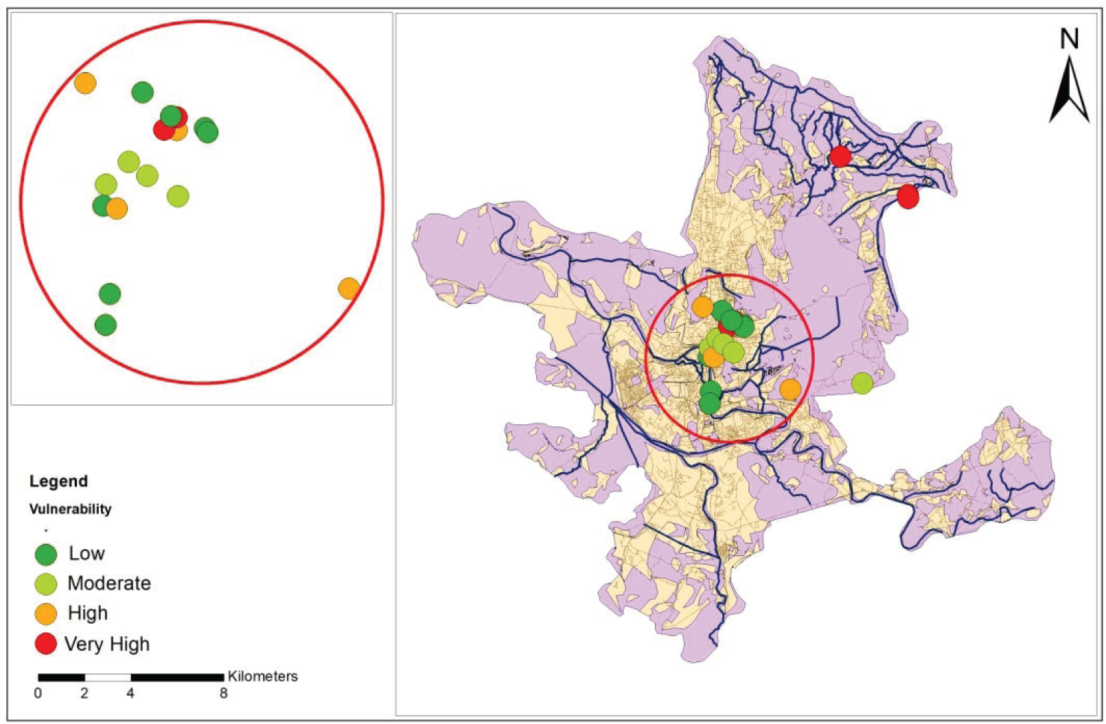
The vulnerability matrix for each site was generated by evaluating the data layers encompassing a 300 meter buffer, and finally, a heritage vulnerability map was prepared for the Srinagar city (Mattei et al., 2019; Rodríguez-Rosales et al., 2021).
Vulnerability Assessment of the Five Spatial and Two Structural Parameters of Selected Heritage Sites in the Study Area
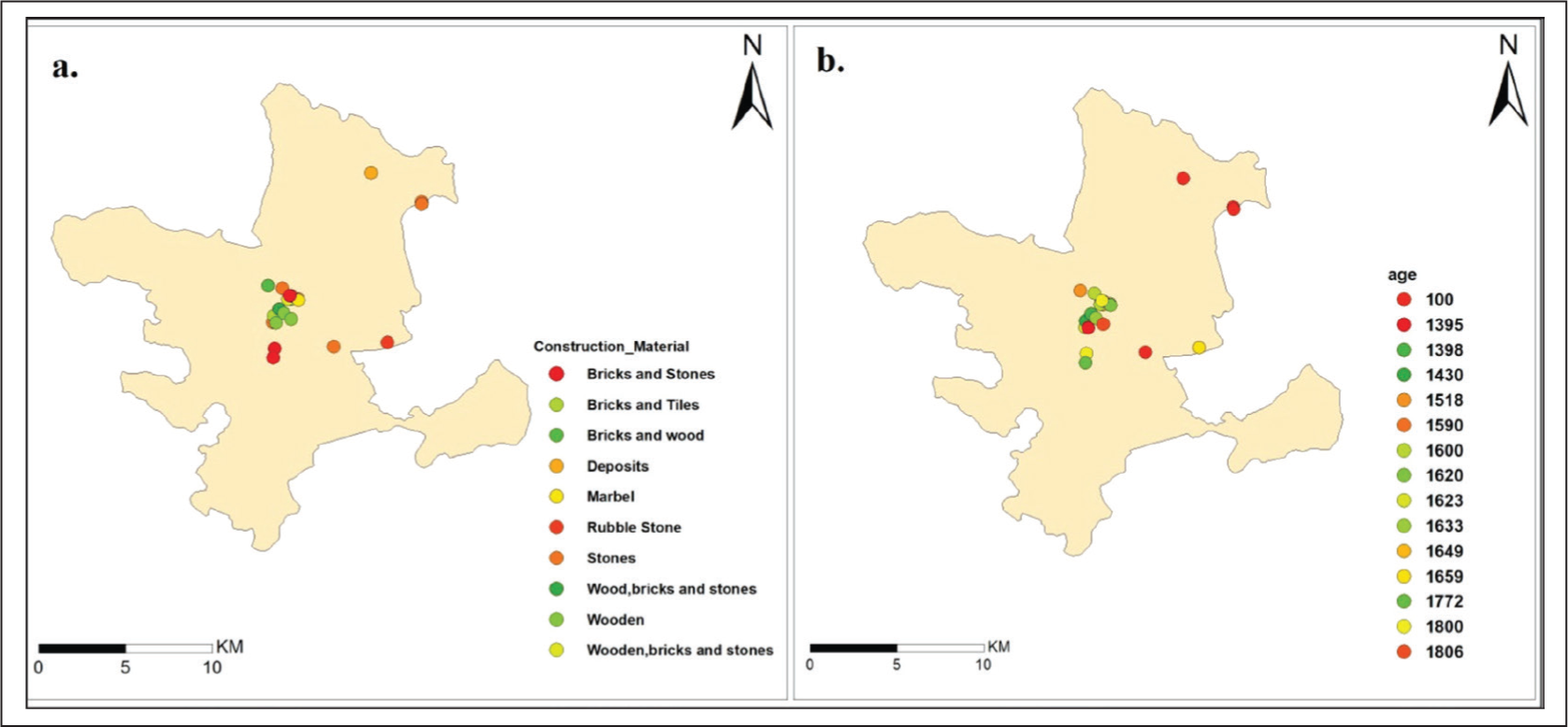
The multi-hazard vulnerability matrix for 20 sites prepared within the delineated 300-metre buffer zones is presented in Table 2, where each parameter was weighted in accordance to the scores ranging from 0 to 1 where 0 means no vulnerability and 1 stands for high vulnerability. From the matrix, a multi-hazard vulnerability map of heritage structures was generated by the summation of individual scores of given parameters for each site as presented in Figure 6. The results of the study show that heritage sites such as Harwan (4.5), Burzahom (4) and Hari Parbat (3.75) are very highly vulnerable to various hazards (mentioned earlier), heritage sites with high to medium vulnerability are Makhdoom Sahib (3.5), Khanqah-e-Moula (3.25), Shankaracharya (3.25), Akhund Mullah shah Mosque (3.25), Imambarah (3.25) and Pathar Masjid (2.5), whereas sites such as Pari Mahal (2.25), Kathi Darwaza (2), Ganpatyar Temple ( 2.25), Sangeen Darwaza (2), Chatti Padshahi Gurudwara (2) and Sharika Devi temple (2) have relatively low vulnerability based on selected variables.
Multi-hazard Vulnerability Matrix of Heritage Sites of City

Discussion and Conclusion
The cultural and ecological heritage is put at an irreversible and ever-increasing risk of damage and eventual extinction as a result of impact from rampant urban expansion, environmental degradation and landscape decay as discussed in previous works (Black & Wall, 2001; Chapman, 2013; Hitchcock et al., 2010; Miksic, 2011). Limited research work has been carried out on the consequences of loss of resources in historical and cultural heritage in comparison to the ecological perspective of the problem in the Srinagar city.
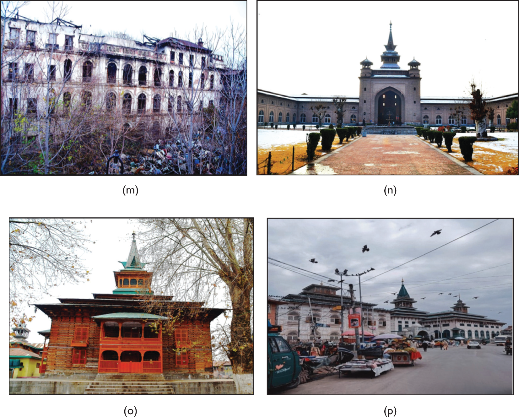
The present condition of Srinagar heritage sites was portrayed by identifying the heritage sites that are vulnerable to multiple hazards. Moreover, from the field survey, it has been observed that the conservation strategies for protecting the heritage from disaster risks do not reflect on the ground. The heritage sites exposed to multi-hazards are not assessed and neither identified. Heritage sites such as Pathar Masjid, Tomb of Zain-ul -Abidin’s Mother, Sher Garhi Palace, Akhund Mullah Shah Mosque and Sangeen Darwaza have been left abandoned and have become more vulnerable to disasters. Structures such as Pari Mahal, Tomb of Zain-ul -Abidin’s Mother, and Harwan excavation site are suffering from deteriorating walls, discoloration and stone structures seem to be highly damaged with minimal to no repair work undertaken. The timber structures like Khanqah-e-Moula and Khanqah-e-Naqshbandi are also deteriorating. The world-famous archaeological site located in Burzahom has turned into cattle-rearing ground, the Harwan Archaeological Site has no road connectivity and the Tomb of Zain-ul-Abidin’s Mother in the central city is connected via a very narrow footpath from the main road. The heritage structures like Pathar Masjid, Kathi Darwaza, Jamia Masjid, and Dastgeer Sahib Shrine share walls with shops and houses, and the Sher Garhi Palace is burnt down due a fire that broke out a few years ago, and still, no action has been taken to renovate the structure.
There is rarely a site where any of the framed conservation strategies from the disaster perspective have been executed. The revised master plan of Srinagar city 2030 has no mention of a disaster management plan for heritage structures and monuments. The 100-metre prohibited buffer zone and 200 metre regulated buffer zone as suggested by the ASI do not exist around the heritage buildings, structures or sites. The emergency response plan suggested by ICOMOS for heritage protection to minimize the damage is not framed yet in the state, which could have included the emergency pathways, fire drills, emergency vehicles, etc., associated with the proper understanding of the property. As per the conservation strategy of ICOMOS, which is to strengthen the structures, resist and reduce the vulnerability, the existing structures are dilapidated and deteriorating. The guidelines published by NIDM for disaster risk reduction of cultural heritage sites were supposed to reduce the exposure to certain elements that can increase the vulnerability of the structures. The condition of Srinagar heritage sites is depressing in terms of the response to these guidelines.
The study finds that most of the historical sites are important from a religious point of view, which thousands of people visit annually. Moreover, these religious sites are located in core areas of the city, and it is difficult to create buffer zones around the sides. However, the location of many structures amid the congested urban settings may increase the adverse impacts on the monuments by manifolds and quicken their deterioration. The constant vibration caused by traffic, appalling levels of pollution, transportation, and other means, physical damage or deliberate vandalism, and arson incidents witnessed in the past have all enhanced the deterioration process of these structures.
The results of the study reveal that majority of the heritage structures are more or less resilient to earthquakes, as monuments seem to incorporate the threat of seismicity in their architecture either through materials or the techniques used and have stood the test of time and incidents of earthquake in the past. Structures which fall in the flood plains, supposedly vulnerable to floods, have never experienced flooding because of the suitable planning of the ancient city. Although factors such as slope failure, deterioration through weathering, or breaching or washing away of banks, and climate change still threaten the structures. It has been found that the damage and decay of these heritage structures have been caused by anthropogenic activities more than the natural hazards, intentionally or unintentionally.
The study supports the perspective of city growth by focusing on preserving the historic–cultural heritage resources recognized as a key element for sustainable development; important measures to be adopted for reducing their vulnerability to disasters; and a way of ensuring their maximum possible vitality, values and functions to benefit the current and future generation. To achieve this, modification of existing management practices and preservation frameworks at both the institutional policy level and local level is required. The study suggests strict measures to be incorporated with the involvement of the various stakeholders such as religious bodies, local people, tourists, communities and government officials to conserve and protect them. Resilient and safe environments should be at the centre of adaptation of sustainable transformations of cities and their heritage for which risk-based approaches should be incorporated with an evaluation of sensitivities (vulnerabilities) and capacities to adapt to existing and potential, natural or human-induced hazards in cities.
Footnotes
Acknowledgements
All parties involved have no conflict of interest and thank all anonymous contributors to the study for their ideas, physical efforts, literary and language, technical and software support and in compilation.
Declaration of Conflicting Interests
The authors declared no potential conflicts of interest with respect to the research, authorship and/or publication of this article.
Funding
The authors received no financial support for the research, authorship and/or publication of this article.