



Abstract
Conservationists around the world advocate for “data-driven” environmental governance, expecting data infrastructures to make all relevant and actionable information readily available. But how exactly is data to be infrastructured and to what political effect? I show how putting together and maintaining environmental data for decision-making is not a straightforward technical task, but a practice shaped by and shaping politico-economic context. Drawing from the US state of Louisiana’s coastal restoration planning process, I detail two ways ecosystem modelers manage fiscal and institutional “frictions” to “infrastructuring” data as a resource for decision-making. First, these experts work with the data they have. They leverage, tweak, and maintain existing datasets and tools, spending time and money to gather additional data only to the extent it fits existing goals. The assumption is that these goals will continue to be important, but building coastal data infrastructure around current research needs, plans, and austerity arguably limits what can be said in and done with the future. Second, modelers acquire the data they made to need. Coastal communities have protested the state’s primary restoration tool: diversions of sediment from the Mississippi River. Planners reacted by relaxing institutional constraints and modelers brought together new data to highlight possible winners and losers from ecological restoration. Fishers and other coastal residents leveraged greater dissent in the planning process. Political ecologists show that technocentric environmental governance tends to foreclose dissent from hegemonic socioecological futures. I argue we can clarify the conditions in which this tends to happen by following how experts manage data frictions. As some conservationists and planners double down on driving with data in a “post-truth” world, I find that data’s politicizing effects stem from what is asked of it, not whether it is “big” or “drives.”
Introduction
When sitting on the beach, facing seaward, if one sees waves come from left to right, the wave direction is positive and so is the longshore transport. (p. 70, 2017 Draft Master Plan Appendix C, Chapter 3-3: Barrier Island Model Development)
Here you are: sitting on the beach, taking in the sun and the sea, and watching the waves roll and crash left to right. Too bad it’s a computer simulation. In this model of barrier island formation and change on the Louisiana, USA coast, it’s 2050, and modelers are able to say something about the basic shape of the shoreline, an average wave height for each hour, and the direction of the waves. The model brings together an assortment of coastal and climate data to predict outcomes for an engineering project that would restore part of the coast’s barrier island chains, which protect inland areas from hurricane storm surges. The goal of Louisiana’s coastal modeling effort is to draw on and produce a wide variety of data to envision these kinds of futures (Coastal Protection and Restoration Authority [CPRA], 2017; see Figure 1). Other components of Louisiana’s Integrated Compartment Model (ICM) have such fine spatial and temporal resolution that it is possible to imagine future vegetative conditions in a marsh south of Houma in April 2041 and the fisheries and storm surge outcomes associated with it, though the epigram is the only statement I’m aware of in which modelers embody their work. What makes this technocentric approach to such a divisive socioecological issue like climate adaptation possible and to what effect?
Around the world, conservationists advocate for the kind of data integration and analysis at the heart of the ICM and Louisiana’s Master Plan for coastal restoration. In such “smart,” “data-driven” environmental governance (Bakker and Ritts, 2018; Ghosh, 2019), data is imagined to be a neutral reflection of reality and therefore an arbiter that can make decision-making more “rigorous,” effective, and based on the “best available science” (Esty, 2018). For instance, the Environmental Defense Fund’s “fourth wave environmentalism” centers digital technologies like remote sensors and data dashboards and sees them as superseding contentious debate around sustainability issues (Krupp, 2018). To let data drive decisions and to move beyond politics-driving, advocates explain that “many analysis problems are really data integration problems – before you can take action, you need all your facts in one place” (Strombolis and Frank, 2014, emphasis added). This putting together of facts is challenging: “it can be difficult to coordinate [data collection] efforts across political boundaries and agencies, and is expensive to maintain over time” (Snider, 2018). But for many conservationists, this data infrastructure—rather than the right analysis or question—is what holds back governance in a “post-truth” world skeptical of established expertise (Dillon et al., 2019; Neimark et al., 2019). 1
In this paper, I draw from the Louisiana case of data-driven environmental governance and ask: how and to what political effect is data made available for decision-making? I situate my answer alongside the work of political ecologists, science and technology studies (STS) researchers, and digital geographers. Political ecologists have shown how scientists are informed by cultural “fields” and material conditions as they translate their knowledge into terms states and capital can “see” (e.g. Lave, 2012; Robertson, 2006). Likewise, as digital geographers explain, normative values and logics are embedded into new forms of data-driven analysis (e.g. Amoore, 2011; Jefferson, 2017; Leszczynski, 2016). When experts create data infrastructures they are therefore not just doing something technical, but instantiating power dynamics. But of what kind? Some political ecologists see policy-makers’ turns to (more) data and analysis as rendering socioenvironmental futures in technical terms (e.g. O’Lear, 2016; Swyngedouw, 2010), while data justice scholars have suggested digital tools and datification might allow for some reconfiguration of hegemonic social relations (e.g. Dencik et al., 2019; Miguel et al., 2019).
I argue that infrastructuring data de- and re-politicizes socioenvironments, but that data’s politicizing effects have more to do with the demands that surround it than its size or neutrality. I show that data is infrastructured not through technical means per se, but through the ways experts manage fiscal and institutional “frictions” to data integration and maintenance (Baker and Karasti, 2018; Bates, 2017; Edwards, 2010). Experts often want to incorporate more analysis, or perhaps even gather new data, in order to more legitimately represent the socioecological processes they and stakeholders care about (cf. Ghosh, 2019; Vance Martin, 2019). Getting more data or doing more analysis may prove not only technically challenging, but institutionally infeasible if it means using limited funding to observe rather than act. I illustrate two strategies by which Louisiana modelers manage these frictions to infrastructure ICM input and output for the Master Plan: they work with the data they have and acquire the data they are made to need. Modelers’ strategies orient toward either institutional constraints or popular challenges and it is on this that data’s politicization hinges. One program focused on data collection has not been implicated in any political demands—cost and institutional frictions to data integration remain rough and the result is arguably depoliticizing as it orients data toward planners’ existing priorities. But in other parts of the modeling, political mobilizations compelled modelers to spend more time and money to bring previously burdensome yet valuable data together to highlight possible winners and losers from state restoration projects—the result was a product of and reproduced dissent. In the first case, data collection depoliticizes coastal change, in the second, more data re-politicizes it. I suggest the differentiating factor is therefore not data volume, and certainly not whether data are allowed to “drive,” but what is demanded of it.
I first provide a brief review of how political ecologists and STS researchers have approached the relationship between data infrastructure and politics in environmental governance. I then illustrate some of the biophysical and political context structuring coastal restoration in Louisiana (see also Nost, 2019). It is marked by twin discourses: that restoration is urgently needed and that modeling coastal change is a waste of time and money. This sets up the two core sections of the paper in which I describe the primary ways experts infrastructure coastal data. I follow modelers’ infrastructuring practices and then turn to two extended examples in the second section to illustrate politicizing effects. I adopt a case study method, as “intensive” research has utility in isolating the “necessary relations” of – in this case, data-driven environmental governance – from the “contingent” or context-specific ones (Johnston, 1991: 224; Sayer, 1992 [1984]). My analysis is informed by semi-structured interviews with over 50 scientists and planners involved in all components of the Master Plan modeling process, as well as coding of public comments on the plan that mentioned “modeling.” I conclude by speculating on the conditions of politicization for environmental data, as conservationists double-down on driving decision-making with it in a post-truth era.
Framework
About 70 experts were tasked with developing, implementing, and maintaining Louisiana’s coastal data infrastructure, ranging across several state and federal agencies like Coastal Protection and Restoration Authority (CPRA), at least three private consulting firms that had staff working day-to-day on the Master Plan, and the nonprofit Water Institute of the Gulf (WIG) that was contracted with to manage it all. That data infrastructures are “peopled” like this is reflected in the advocacy group GODAN’s (2016: 55) definition: they consist of datasets and analytical tools, but also organizations, “processes that make datasets useable” and the people “build[ing] and maintain[ing] data.” STS scholars have dealt extensively with the making and effects of data infrastructures. Crucial to this was Star’s (1999) flipping of existing approaches to infrastructural analysis. Star asked when rather than what is an infrastructure and highlighted the practices that comprise it, which Star and Bowker (2002) later called “infrastructur-ing” (see also Karasti et al., 2010; Parmiggiani et al., 2015). For Star and Ruhleder (1996: 114), “an infrastructure occurs when the tension between the local and global is resolved,” such as when modelers integrate data in one repository with data from others, enabling seamless and extended use (Lippert, 2015). Building from this, Edwards (2010) argued that knowledge about the world’s changing climate is infrastructured—produced, accepted, built upon, scaled globally, and reproduced—through sociotechnical practices that involve not just data storage platforms and predictive models, but rules and standards. These relational ways of thinking about infrastructure were developed alongside feminist STS scholarship that sought to reveal the normativity of technoscientific devices. Eschewing notions of objectivity rooted in white male fantasies of a “view from nowhere,” feminist STS scholars instead show how claims to objectivity—e.g. that neutral facts drive decision-making—come from somewhere and that knowledge and technologies “encode,” “embed,” “script,” or indeed “infrastructure” values and logics (Akrich, 1992; Haraway, 1999 [1988]; Harding, 1987; Jasanoff, 2017).
STS scholarship on infrastructure can extend political ecological ways of explaining environmental expertise’s “production, circulation, and application” to policy- and decision-making (Goldman et al., 2010; Lippert, 2015; Porter and Demeritt, 2012). Political ecologists show how, for instance, actor-networks enroll allies to make portable abstractions that can travel through centers of calculation (Holifield, 2009), the commercialization of science repackages knowledge in forms amenable to neoliberalizing states and corporate interests (Lave et al., 2010; Randalls, 2010; Webber, 2017), and that cultural norms and capital make knowledge legitimate (Lave, 2012). “Translation” is another concept with STS roots that critical environmental scholars often draw on (Ascui et al., 2018; Robertson, 2006; cf. Machen, 2018). States and capital require different kinds of knowledge; this knowledge must be “translated” into a format amenable to what each can “see.”
Infrastructuring covers similar territory as political ecologists’ existing work on expertise but offers potential empirical and theoretical advantages. Empirically, what environmental data scientists and around the world are doing is building infrastructures—repositories, archives, and platforms—for decision-making (Kitchin and Lauriault, 2015). They are bringing together diverse data- and toolsets, adapting them, embedding them into planning process, and maintaining their efforts (Gabrys, 2016). More conceptually, infrastructuring focuses our attention toward how actors navigate the kinds of abstraction central to translation, since infrastructures are standards arising alongside immediate needs. Infrastructure is when “local” data siloed in one single model or separate repositories is integrated with others, or when standard models are adapted for local purposes as well (Miguel et al., 2019)—in either case to be “used in a natural, ready-to-hand fashion” (Star and Ruhleder, 1996: 114). Crucially, this infrastructure can break down when it becomes (re)siloed, out of date, programmed with bugs, or does not match the expectations of stakeholders. The infrastructuring lens gets us to see practices of maintenance in a way that translation may not (Baker and Karasti, 2018; Eghbal, 2016; Mattern, 2018; Russell and Vinsel, 2016).
A turn toward infrastructuring practices, however, does not have to mean losing sight the de- and re-politicization of socioenvironmental issues. After all, infrastructure in general is a vantage point for geographers to specify taken for granted hegemonic systems (Barnes, 2017; Kaika and Swyngedouw, 2000; Ranganathan, 2015), their limits (Anand, 2011), and, in general, the material, affect, and labor that holds worlds together (Berlant, 2016). All infrastructures—concrete (Akhter, 2016; Anand, 2011; Colven, 2017; Kaika and Swyngedouw, 2000; Ranganathan, 2015), biophysical (Carse, 2012; Carse and Lewis, 2017; Lewis and Ernstson, 2019), or digital (Alvarez León, 2018; Lally et al., 2019; Pickren, 2016; Starosielski, 2015)—reflect, reproduce, and rework distributions of wealth, power, status, and visibility. We can detail how those making data useable and maintaining it encounter and respond to forms of what Edwards (2010) calls “data friction.” Data frictions are factors that slow data’s circulation between, for instance, social media platforms or, in the Louisiana Master Plan, between agencies’ data repositories, within ICM submodels, or between different components of the integrated model. Not only do such frictions generate “heat,” or controversy and disagreement, but they are also political and economic in origin, having to do with funding levels and planning commitments and shaped by struggles (Bates, 2017). They are ultimately a relational product of forces conspiring to slow data’s circulation and those compelling it (Bates, 2017). In Louisiana, experts must confront cost, time, and organizational frictions stemming from austerity, a sense of crisis, and siloed resource agencies—all in relation to desires for more complete, timely, precise, or accountable data.
Data frictions and responses to them therefore tell us something about politicization. In making this claim, I am building on recent calls to specify how exactly technologies like modeling foreclose futures and under what conditions (Dempsey, 2016; Robbins and Moore, 2015). I argue technics need not (re)produce consensus. Through the lens of technopolitics, political ecologists see experts as deliberately using technology to achieve political ends, often circumventing public debate and dissent in the process (e.g. Akhter, 2016; see Hecht, 1998). This might result in a “post-political” condition, in which socioenvironmental issues are framed as a matter of more, indisputable numbers and incremental “win-win” fixes, rather than “proper,” adversarial, and liberatory dissensus that “focus[es] on where, how, why, and by whom conflict and disagreement are generated.” (Fletcher, 2014; Kaika, 2017: 94; O’Lear, 2016; Swyngedouw, 2010; cf. McCarthy, 2013). Yet, as I show below, in Louisiana experts acknowledge “tough decisions” rather than “win-wins” and have brought together data specifically to address the winners and losers of coastal change. More data, a result of frictions mitigated or smoothed, can change an issue’s framing; in general, quantification can re-politicize and undermine state and hegemonic claims (Akhter, 2016; Chatterjee, 2019). As seen by data justice researchers Dencik et al. (2019: 875), data can be “an avenue to … (re)creating conditions of possibility for counter-imaginaries and social justice claims to emerge.” Data’s political work may be unintentional. As Freidberg (2014: 179) reminds, “tools, plans and bodies of expertise that do not achieve stated goals can still produce ‘new forms of power and agency’”. Experts’ work can leave open spaces where contestation can take root. As Turnhout et al. (2007: 222) elaborate, there is a paradox in experts’ “trust in numbers”: “[science] is intended to close the debate, but instead only enhances it … ” because it generates debate about the numbers themselves; they provide something to question. In short, data infrastructuring can be a part of proper politics, in which the framing of and nature of social power are contested. Below, I explain how modelers manage data frictions, in order to spell out when their strategies for infrastructuring data have depoliticizing and conservative effects and when they are generative of space for politics.
Context: How much data and analysis?
While scientific integrity and defensibility are paramount to the process, every conservative assumption, every additional project documentation requirement, and every field monitoring component must be considered with an eye towards bottomline economics. (Louisiana coastal planners in the National Wetlands Newsletter—Zeringue et al., 2014: 13)
In this section, I sketch out the biophysical and political environments in which modelers operate while developing their analysis for Louisiana’s coastal Master Plan. These, especially political discourse, generate frictions to infrastructuring data that modelers must manage. In ecological terms, Louisiana has lost, on average, an acre of wetlands every 100 minutes since the 1930s (Couvillion et al., 2017). Wetlands loss occurs when marshes and forested swamps convert to open water. Eustatic sea level rise from climate change is one driver, but the relative rate of rise on the Louisiana coast is the highest in the world due to the subsiding of deltaic soils (Goldenberg, 2014). These soils would otherwise be replenished from Mississippi River distributaries, but the river has been leveed since the 1927 floods. In between then and today, the oil and gas industry carved thousands of miles of canals through coastal marshes in order to lay pipelines and extract fossil fuels. Canals now funnel storm surges and have enhanced marsh deterioration (Turner, 1997). While these “wicked” socioecological problems have been identified since land loss first started (Viosca, 1928), only in the 1980s did any sort of movement toward coastal restoration crystallize (Theriot, 2014).
Today, coastal restoration is widely acknowledged as necessary and urgent. But data collection and analysis are considered expensive and there is extensive debate in Louisiana about the relevance, necessity, and accuracy of ecological and engineering expertise in general and their application in modeling specifically. A significant portion of this skepticism stems directly from the failure of levees in New Orleans during Hurricane Katrina. Despite spending billions on research and construction, the Army Corps of Engineers’ (Corps) levees failed. While the Corps rebuilt a levee system after “the federal flood,” the system and the modeling behind it evoke little trust. Many Louisianans are worried that restoration projects will be another waste of money that will not actually provide any results. In particular, they doubt the proposed but untested billion-dollar diversions that will siphon sediment from the Mississippi River into degrading basins. The question skeptics pose is, as one journalist put it, “should we study diversions to death or build them?” (Schleifstein, 2016).
Skepticism about “studying diversions to death” is shared across popular and expert perspectives. At a public meeting on the draft 2017 Master Plan, a black reverend put it this way: “Some of these projects are not going to take place until twelve years from now, but [look at] the amount of money being spent for project design … ” He went on to question who might be profiting from the model development: “I just think that we’re being Trumped by the Master Plan. I think the Master Plan, as I’ve always said, is the Master Plan. And that is a plan where those who are rich and influenced can make money” (CPRA, 2017: G1, p. 200). Black neighborhoods of New Orleans, post-abolition freedmen’s towns such as Ironton, and other coastal communities of color face environmental racisms from land loss, petrochemical processors, and ongoing state disinvestment (Barra, 2016). “Studying diversions to death” takes on a literal meaning for some given this continued production of “group-differentiated vulnerabilities” (Gilmore, 2006).
What models predict about diversions also leads communities (of color) to question coastal science. In public commentary about the Master Plan, coastal residents have pushed back against modeling predictions and proposed projects. Some towns, like the majority-white shrimping center of Jean Lafitte, protest predictions that they may actually be more exposed to flooding after restoration projects are completed: “We don’t need more water. They’re going to pump more water on us, but we’re already trying to keep our heads above sea level” (in Baurick, 2017). Fishers have also expressed concerns about sediment diversions (Barra, 2016; Lewis and Ernstson, 2019). The coastal fishery is in no small part comprised of Vietnamese/Americans who migrated to the area in the wake of the Vietnam War. Constituting the single largest grouping of comments, over 100 such fishers signed and submitted letters expressing concern about how projects proposed in the draft 2017 plan would affect them (CPRA, 2017: G2; see also Kang, 2018). Nearly two-thirds (61 of 99) of public comments on the draft that specifically mentioned modeling discussed its inadequacies. A significant share were from coastal residents who, backed by an environmental action group called Gulf Restoration Network (GRN), questioned whether CPRA prioritized low-income communities in its cost–benefit model of projects (CPRA, 2017: G2). A vocal charter boat captain protested how diversions modeling had been conducted: “We said from the beginning the only fair study would be one that looked at all [restoration] options, not just diversions” (in Marshall, 2015), while another fisher elaborated: “They say they base the Master Plan on the best science available, but they’re not using all the science” (in Snell, 2018). Communities ask, why spend so much time and money on limited studies of these proposed projects?
Concern about “studying the coast to death” also comes, in a different way, from modelers and scientists themselves. Journalist Bob Marshall (2016) summarizes the bind state experts see themselves in: If the state waits too long to act [because it has asked scientists to do studies], most of the coast will have been swallowed by the Gulf of Mexico, resulting in the loss or relocation of the communities and vital industrial hubs it aims to save. But if it errs in selecting a strategy and projects [i.e. if the science is wrong], it might then lack the money to begin new work.
In short, the cash-strapped state is facing a time-sensitive land loss crisis with no win-win solutions, just expensive remedies that have never been tested before and that therefore must be studied and modeled by the wide range of entities that have relevant expertise. Discourse in Louisiana right now scrutinizes the time and money spent on coastal restoration research. In response, CPRA planners organizing the MP modeling process laid out deadlines and funding protocols, while giving modelers flexibility in producing deliverables. When modelers infrastructure data for the ICM, they have to manage politics-driven cost, time, and organizational.
Two moments in making environmental data infrastructure
Proverb 1: DON’T PANIC … Typically, the programmer may be loaded down with other work. Your instructor or management may be putting on the pressure by setting an unrealistic schedule or by promising a bonus for finishing early … . If you find yourself upset or ploughing ahead with a new programming assignment, 1. Stop. 2. Calm down. 3. Return to methodical programming techniques. (FORTRAN with Style: Programming Proverbs, Ledgard and Chmura, 1978: 5)
Work with the data they have
I think as scientists we have an affinity to want to go and collect data. I mean we like to go to the field, we want to learn and get the most up to date, precise information that we possibly can … . I think you have to ask yourself, what is the risk of not having it? What if it’s not possible – you don’t have the funding to hire a boat driver to take you out or you can’t get landowner permission … . How important it is that I really go and collect temperature data or can I just use the air temperature probe over there, can I correlate it to this? How can we be creative and analyze the data we already have? I’m a big proponent of that, even though I love field work as much as the next person. (Interview with modeler, March 2016)
By leveraging data, modelers manage both fiscal frictions to data collection and organizational challenges to infrastructuring data into the Master Plan process. Experts leverage the wide variety of existing coastal data by curating it, giving them clearer picture of what they can use in their models. A fisheries modeler explained to me that before she began modeling, she had to spend a lot of time just figuring out what data was where. What she wanted was housed in many different archives. Some of it was managed by the Louisiana Department of Fish and Wildlife. Other databases were associated with the state’s Coastwide Reference Monitoring System (CRMS), which has been described as the “largest freely accessible coastal monitoring program in the world” (Snider, 2018). But there was no synoptic view. This was in part a product of different agency missions, and it turned into a matter of knowing the right contacts at each agency: they collect data to meet their legislative mandates and they have their own requirement. So the way they store it and the way you get it is very different. I know who to contact at Wildlife and Fisheries to get their data. at each individual point how long they’ve been collecting data, what do they collect there, how often do they go, and what are the units? These types of things for every single point all across the coast – and that’s an amazing amount of information.
Infrastructuring data is not just about curating datasets but its circulation within and between models. Master Plan modelers work with the models they have as they are often constrained in building new tools for the ICM. At the outset of the 2017 Master Plan effort, planners mandated modelers use already existing tools: “costly and time-consuming new development of post-processing and visualization techniques will be avoided or at least kept to a minimum” (CPRA, 2013b: 33). As one consulting programmer reflected: “With software development you’re balancing several interests … For the Master Plan, time was not a luxury (laughs), so in deciding what to include, that was narrowed down by the time equation” (Interview, October 2016). Rather than building extensive new tools, Master Plan modelers—and the programmers they collaborate with—focus on accessing existing models and tweaking them.
Tweaking models is a tactic to manage cost and time frictions. The Louisiana coast is a mosaic of open water, marshy, and dry terrain that can be relatively dynamic. It is the kind of place where social scientists studying adaptive management find themselves deeply skeptical about the abstract expertise embedded in models. Many of the models used in the Master Plan, in fact, are based on “turnkey” software meant to be applied anywhere. But as one Louisiana modeler put it, they would rather not “plug and chug” with standard models. Modelers want to try to capture the complexity of coastal biophysical processes as much as possible by adapting these off-the-shelf tools (cf. Landström et al., 2011). For instance, the coding behind the fisheries model had to be refined to enable accurate geospatial projection of the Louisiana coast and to exclude certain areas from the model they knew would not actually ever see fish (CPRA, 2017: C3, p. 30).
Beyond tweaking, modelers want to maintain, update, and repair what they have, so as to enable its circulation within the planning process against organizational frictions. For instance, they plan to refresh the curated dataset described above every five years. This is an acknowledgement that data collected by separate resource-governing agencies tend to silo itself—“because monitoring [data collection] is conducted by several different agencies, an inventory database should be developed … in order for the most relevant and recent datasets to be incorporated” (CPRA, 2017: F, p. 25). Yet modelers’ maintenance practices themselves run up against time and cost frictions. Modelers could pay for better software to work out bugs, but this is expensive. One programmer argued to me that “if you had lots of time, you could develop high quality software – you could work out all the bugs.” Instead, modelers’ maintenance is often interpersonal. As one team defined themselves: “we are data integration. We are sitting in a role where we help to provide glue between teams.” Providing “glue between teams” is of course technical—including a not insignificant amount of effort standardizing file names!—but it is also about managing people. As another MP modeling participant added, To make something like this work you have to include people that have not only the expertise but … a personality that just doesn’t keep throwing wrenches into the process … You have to make sure that when someone is giving an update on their portion of the model that the model team ‘downstream’ of them is actually listening to make sure it all jibes with what their subroutine needs.
Different practices of maintenance are thus ways modelers work with what they have in order to make data circulate in the ICM.
To infrastructure data—that is to integrate agency-siloed data, connect the outputs of ICM submodels, and avoid buggy and corrupting output—Louisiana modelers have to manage cost and time frictions. In the face of a land loss “crisis” and budget shortfalls driven by the fluctuating price of oil, the state does not have all the time and money in the world. Instead, modelers will often work with what they have. They leverage, tweak, and repair and maintain.
2. Acquire the data they are made to need
If Louisiana modelers assess existing datasets and determine they cannot leverage what data they already have or tweak their models, they plan to acquire what they need. One of the leads on the fisheries submodel in the ICM described the approach as “targeted data collection efforts.” These tend to be seen as last resorts given budget and time frictions, but political mobilization can shape the intensity of such frictions. In other words, what modelers “need” is a product of politicization or a lack thereof. I illustrate this with two examples of how experts infrastructure new data, and these in turn have diverging politicizing effects.
2a. Data for adaptive management
First, modelers have determined that even though it may be the world’s “largest freely accessible” source of coastal data, CRMS will be insufficient for measuring and adapting to the impacts of restoration projects when they are built. To get what data they need, modelers and planners are creating a monitoring program called System-Wide Adaptive Management Program (SWAMP). The SWAMP data infrastructure will expand a series of biophysical and socioeconomic monitoring data collection efforts across the coast and integrate them (see Figure 2), in order to evaluate the performance of restoration projects over time against agency goals. The biophysical data measure variables like salinity, turbidity, and land cover, while the socioeconomic datasets will assess measures such as income, property values, and “ecosystem dependence.”
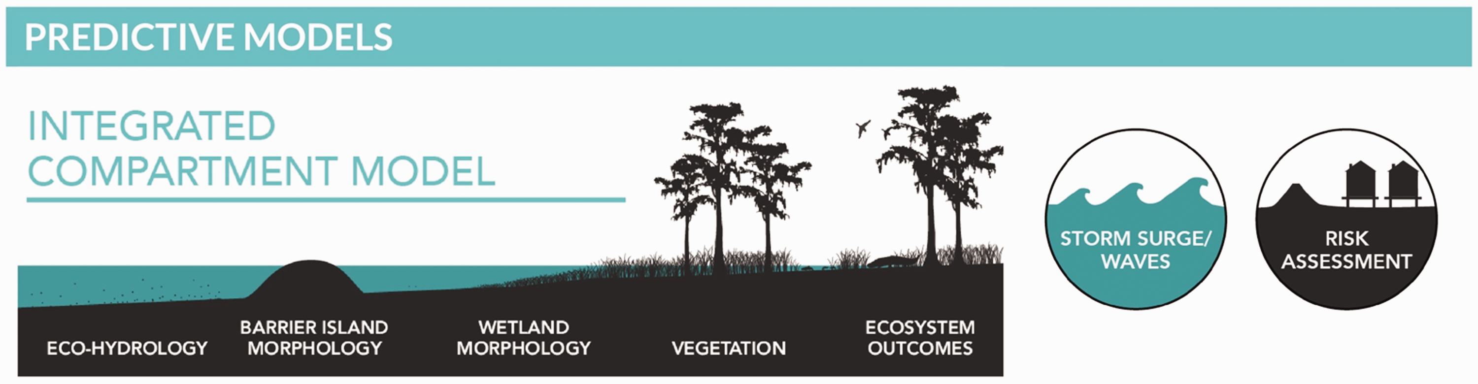
The different components of the Louisiana coast that experts must bring together in the Master Plan. In turn, each of the submodels requires integrating and maintaining a range of data sources. Source: http://coastal.la.gov/our-plan/2017-coastal-master-plan/planning-process/modeling/.
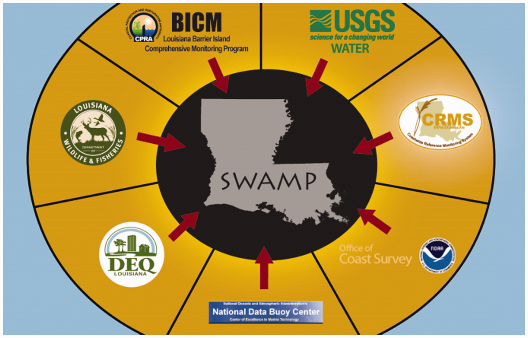
The different state organizations whose coastal data must be integrated in the SWAMP program. Source: https://www.lacoast.gov/crms/crms_public_data/publications/CRMS_FactSheet_Web.pdf.

CPRA map showing uneven flood risk reduction. Areas in red would see increased flood depth in 2050 under the MP. Similar maps were presented in public meetings on the draft plan. Source: http://coastal.la.gov/wp-content/uploads/2016/04/MPModelingWebinar_Sept222016_Final.pdf (p. 152).
SWAMP is defined by an effort to target data collection in line with frictions such as existing policy goals. At the core of SWAMP, modelers utilize the “card catalog” or inventory of existing datasets and perform a series of power analyses to constrain just how much data they will need to make statistically significant claims about the changing coast (CPRA, 2017: F). Power analyses are essentially statistical correlation in reverse: It’s all centered around, what do you want to be able to detect in that variable? Do you want to be able to say that there is a one percent change in fishery abundance from one year to the next? Or are you like, I’d rather be able to detect a 20 percent change, and maybe in this particular variable it’s more important to get the finer scale changes. So [SWAMP] was all about kind of forcing us to think about: what do we need to use the data for? We kind of took a step back and thought OK what are all the things we can possibly measure along our coast and can we prioritize these? … In the end, we ended up with a laundry list of variables through several iterations with CPRA and sitting around a table and identifying you know what’s most important for the projects they’re looking to build?
Louisiana experts seek out biophysical and socioeconomic data they need for SWAMP, but ultimately it “relies heavily” on the data they already have (WIG, 2015: xii). The program is about collecting more information, but experts are led to target their data collection. In doing so, they ask, “with our existing resources and planning commitments, what can we learn?”. Even though a main goal of the new data infrastructure is to expand the range of data they are collecting to include socioeconomic characteristics of the coast, targeting limits empirical material for future forms of dissent because it centers existing plans and budgets. The data available in the future will be geared toward evaluating diversions’ ongoing impacts in terms of resilience, rather than other goals for the coast or even as-of-yet unknown questions. This depoliticizing effect stems from infrastructuring data via efficiency and austerity, not because coastal change becomes something mediated through technical means and more data collection.
2b. Data for predicting diversion impacts
The second example of experts acquiring what data they need illustrates how political demands work through data to re-politicize coastal futures. As shown above, generally modelers face frictions to integrating new toolsets into their work. But these can be eased in the face of calls for accountability. Modelers have spent additional time and money to bring together both input and output data, in ways that make up for key shortcomings in predicting diversions’ impacts on fisheries and flooding.
Modelers realize that no single model is perfect—they try to avoid “putting all our eggs into one basket”—and they are afforded this by political demands that make cost and time less frictional. Experts work with two kinds of models and data to understand fisheries impacts. Their habitat suitability index (HSI) approach is readily justifiable: as one modeler noted, “HSIs are easy to communicate … you know they’ve been around forever – since the 1970s or 80s – and everybody uses them.” HSIs are also relatively easy ways to pre-empt cost and time frictions posed by sprawling toolsets. Discussing the 2012 plan, a modeler explained, This happens all the time: you set up to do something simple and people just want to hang on all kinds of bells and whistles. But, no, we built these tools for the 2012 plan based around simple hydrology inputs and simple outputs.
Despite general guidance to “minimize development of costly and timely tools,” experts have had to acquire other data in response to fishers’ protests (CPRA, 2013a). Their data infrastructure is in part a product of dissent. One modeler reflected: I understand what they [fishers] are saying. Like when you run a freeway through a little town. They’re saying oh well you’re going to do all this but you haven’t gotten your shit together and shown us truly what you know.
Because of demands to account for their predictions and plans, Louisiana modelers faced fewer frictions to integrating additional datasets on diversion impacts. They were explicitly asked by CPRA planners to spend resources to understand “the distribution of change by community,” especially with respect to how diversions will modify flood depths. Rather than submerging controversy and turning toward consensus-based discourse, experts explicitly acknowledge that their plans will have distributional effects, redistributing flood levels. CPRA planners explain that in coastal restoration, “there will be winners and losers” (notes from 2016 State of the Coast conference). As one consultant pointed out about flooding, restoration is not a win-win: “Of course it’s always a tradeoff. The water needs to go somewhere” (Hasselle, 2017). But output data from the flood depths modeling—turned into maps—reignited controversy (see Figure 3). For instance, the community of Jean Lafitte is expected to see increased flood depths with the proposed Mid-Barataria diversion and Master Plan maps show areas like Jean Lafitte that are predicted to lose—the “somewhere” that the water “has to go.” These were presented in public meetings, leading residents to protest, “nobody wants this [diversion] here” (Baurick, 2017). Louisiana experts themselves lament but accept this map-oriented contestation: “People will look at their own backyard and say you know this is what the model says, it’s going to happen [and they will protest].” Rather than closing debate, more data and analysis have opened themselves up to and enhanced dissent.
Even if unintentional, integrating more data inputs and outputs into the Master Plan undermined the state’s investment in diversions as its primary restoration approach. At least in this aspect of the Plan, infrastructuring data opened up problems for the state as much as it foreclosed or resolved them. Protests and demands for accountability eased frictions to acquiring more data on fish populations and integrating flood modeling outputs to show expected differences. Integrating additional forms of data reframed the question of diversion impacts from habitat to fish, and from what will happen to who would be differentially affected. The data were less defined by institutional goals. This in turn has facilitated further contestation, as the reframed predictions give something for coastal communities to point at and dissent from. Re-politicization can result from or be engendered by more data.
Conclusions
It is vital that modelling is not left to modellers! (O’Sullivan, 2004: 291)
Let’s return to that virtual barrier island beach, watching the waves in 2040. We’re here at this particular configuration of digital sand and water because of the way modelers infrastructured data for the Master Plan—how they managed technical, fiscal, and institutional “frictions” to integrating and maintaining data in the ICM. They worked with the data they have—making it available, tweaking it to fit the coastal context, and updating it through curation and time- and money-saving practices—and they acquired the data they were made to need. The lens of infrastructuring helps us see another layer of the making and application of environmental expertise beyond the translation or legitimation of knowledge per se. It points our attention to maintenance and how “global” or “ready-at-hand” facts are made available from heterogenous datasets and vice versa: how standard modeling software is adapted to local practice in order to be available for decision-making. Louisiana experts face hard frictions to infrastructuring diverse biophysical and socioeconomic data when they design programs like SWAMP. As such, they plan to collect only as much data as they can afford with existing budgets and that is relevant to existing policy goals. Louisiana experts face less friction to integrating data—in the form of outputs from new models—for the fisheries and flooding predictive modeling. What differentiates the data frictions between these two components of the state’s restoration program is that predicting diversion impacts has been politicized in a way that their evaluation has not. There has been relatively minimal debate around SWAMP itself or, more generally, what needs to be measured in the future. In the ICM predictive modeling, there are calls to “show us what you truly know” and demands about what needs to be measured now about the future.
To what effect this infrastructuring? What matters is what these data infrastructures are asked to do, not how much data there is. What differs between the two components of Louisiana’s restoration program presented here is how political demands have pressed upon the modeling process, shaping the institutional and fiscal frictions modelers encounter, and ultimately the questions they pose of the data. In SWAMP, getting more data is justified for any number of political and scientific reasons, but when modelers and planners target their data collection, they are asking, “what insights about our planned investments will existing resources get us?”. The depoliticizing effect stems from data infrastructured in an austerity-constrained and institutionally focused way, limiting terrain for future forms of dissent. When the question asked of more data is instead made to be, “what coast do we want for whom?”—as it was for predicting diversion impacts—more data can prove productive of dissent. Less focused on institutional goals, it centered the question of who is “we,” who will win and lose, and so on.
In this paper, I presented a case study of how environmental data are infrastructured for decision-making and to what effect. In following the work of modelers involved in the Louisiana Master Plan for coastal restoration, I identified “necessary relations” and factors shaping data-driven conservation that would be relevant anywhere, if in different degrees depending on the context: institutional frictions like siloed agency missions, cost frictions stemming from forms of austerity, desires to adapt standard models to context, the necessity of maintenance, and demands for accountability. The paper speaks broadly to discussions of nature’s politicization. Undoubtedly, experts are often explicitly interested in using models to ease resource conflicts (Dietz et al., 2003; Kelly (Letcher) et al., 2013), and one main way socioenvironments become depoliticized within governance is the claim that “we just need to gather more data.” However, data infrastructures can also be generative of conflict and reproduce it, and the Louisiana case clarifies some conditions in which this may happen. As such, it contributes to STS work on infrastructuring by illustrating its political and economic dimensions, not just its more technical or institutional aspects. The case also contributes to existing scholarship in political ecology, extending how we approach knowledge politics by highlighting the infrastructural components of environmental science and their maintenance.
Data infrastructures are just one place where the stuff of politics—demands, interests, deliberation, and distribution—are all routed. At every step of the Master Plan modeling process, experts confront status quo funding levels, dataset availability, and so on. These are moments where activists could create the conditions by which modelers encounter different data frictions or even directly engage modelers about different questions to ask of the data (Colven and Thomson, 2018). For example, the GRN has delved into the Master Plan model appendices to understand how communities are ranked for adaptation funding. GRN has argued that the state’s current algorithm could be flipped to prioritize those with the fewest resources (Sarthou, 2017). A new algorithm would not be a replacement for politics, but a venue they can be pushed. It would not mean programming the models with the “right politics” alone, but producing the conditions by which data and models are programmed with the right politics (i.e. that ask the right questions) and their outputs are politicized.
We should not mistake the detailed futures modelers simulate as suggesting an equivalence between precision and objectivity—that more data necessarily means a “better” model better for everyone. There are only differently interested data and models. To further understand environmental science–policy interfaces in a big data era, therefore, we need to understand modelers’ practice, not just how much data are available to them. What often shapes the translation of science into policy is not the unwieldiness of big data or the scarcity of data. It is the availability of “ready-at-hand” data that has less friction with institutional and fiscal limits. And while it is important to examine how conservationists put “all their facts in one place” as infrastructure, analysis or its “problems” are not reducible to getting the infrastructure “right.” As some conservationists and planners double down on driving with data in a “post-truth” world, data’s political effects stem from what is asked of it, not whether it is big and certainly not whether it drives.
Highlights
Conservationists advocate for “data-driven” environmental governance Infrastructuring these data is not a straightforward technical task; it requires managing fiscal and institutional “data frictions” Drawing from Louisiana, USA’s coastal restoration program, I show how experts both work with existing datasets and acquire new ones By following how experts manage data frictions, we can clarify when technocentric environmental governance does and does not foreclose dissent Data’s politicizing effects stem from what is asked of it, not whether it is “big” or “drives”
Footnotes
Acknowledgements
I greatly appreciate the constructive feedback of three anonymous reviewers, Jenny Goldstein, and Morgan Robertson, but all errors are my own.
Declaration of conflicting interests
The author(s) declared no potential conflicts of interest with respect to the research, authorship, and/or publication of this article.
Funding
The author(s) disclosed receipt of the following financial support for the research, authorship, and/or publication of this article: The research for this article was supported by the American Association of Geographers Dissertation Award, the University of Wisconsin-Madison Center for Culture, History, and Environment, and the University of Wisconsin-Madison Holtz Center for Science and Technology Studies.