




Abstract
This article contributes to the genealogy of green infrastructure design by shifting the focus from science and technology to include broader societal, political and aesthetic issues, using a critical historical analysis of landscape design. We examine post-war Belgian green infrastructure projects by landscape architect René Pechère (1908–2002) to uncover the complex negotiations between politics, aesthetics and technology. The focus of this article is Pechère's conception of the ‘Green Plan’, which merged the motorway and the garden to create the Belgian landscape as a ‘garden territory’. We argue that this landscape policy was not merely a ‘green’ compensation for a ‘grey’ infrastructure project, but a strategy to create a modern infrastructural landscape for Belgium. Pechère's plans served as instruments for modernisation within the post-war welfare state in combination with aesthetic principles rooted in fascist Germany. His objectives were to mitigate urbanisation processes, create an aestheticised landscape representation of the nation, and redistribute green spaces across the territory. This article aims to foster a critical re-engagement with contemporary infrastructure design discussions by developing a nuanced understanding of green infrastructure as a sociopolitical tool for territorial organisation.
Keywords
Introduction
A ‘politics of gardens’ must provide a solution to the conflict that positions green spaces against the need to expand the built environment. (Pechère, 1946)
To approach infrastructure as art can provide a way of dealing with the violence it interjects into the urban system and become a means of creating civic meaning. (Ingersoll, 2006)
In 1958, the Belgian Ministry of Public Works published a booklet called the Plan Vert, or Groenplan (Green Plan) (Het Groenplan, 1958), a set of government guidelines for the landscape design of infrastructure. In a foreword to the publication, the young King Baudouin of Belgium expressed his concern about the modernisation of the existing road network and the construction of new motorways, which he felt were degrading the beauty of the Belgian countryside. Although he did not underestimate the population growth, the new demands for mobility and the post-war economic reconstruction that underpinned the infrastructural expansion, he felt that ‘the natural beauty of our regions, as much as our monuments, must be protected more effectively’ (Het Groenplan, 1958). To that end the Plan Vert provided a number of recommendations for landscape development to be taken into consideration during the construction of new infrastructure. Three years after its publication, the Ministry established the Service du Plan Vert (Green Plan Agency) to ensure the implementation of the guidelines of the book. The agency was responsible for the planting of greenery along infrastructure works, the management of parks and gardens in Brussels, and had an advisory function regarding the planting policies of other administrations (Velle, 1993). Both the content of the book and the agency itself were influenced by the designs and writings of landscape architect and conseiller aux espaces verts (counsellor for green spaces) René Pechère (1908–2002). Pechère was instrumental in both the conception and the implementation of the Plan Vert. He envisioned the future of the Belgian landscape through the construction of large-scale infrastructure works and used his connections with the Ministry of Public Works to push his agenda. 1
Pechère's ideas about the future of the Belgian landscape were not inspired by the conservative reflex of landscape protection, as suggested in King Baudouin's foreword, but were anchored in the development of an extensive network of motorways. Green landscapes were not at odds with concrete and steel. On the contrary, he approached the motorway infrastructure as an opportunity to redesign the landscape, and vice versa, working towards what could be called a ‘garden territory’ at both the national and the urban level. On the urban scale, and more specifically in Brussels, he developed these ideas into a concept of a green network to facilitate ‘grey’ urban development. In Pechère's work technology does not disrupt the pastoral ideal, instead nature and technology are reconciled in a harmonious garden territory. Internationally, the landscaping of the motorway has been the subject of much scholarly scrutiny, focusing in particular on the observer's experience of the technological sublime or ‘driving spaces’, in the development of, for instance, the German Autobahn and the American Parkway (Gandy, 2002; Merriman, 2007; Zeller, 2007). We argue that in Belgium, landscape design found a much more ‘gardenesque’ translation: that is, the garden was ‘blown up’ to the urban and territorial scales to create an image of a hybrid yet harmonious countryside. Other histories of landscaped motorways in Europe and America have been analysed as expressions of National Socialism (Moraglio, 2017; Wolschke-Bulmahn, 1997) or as the creation of a techno-pastoral garden leading to a privatised form of public space (Gandy, 2002), among other interpretations. Our research on René Pechère serves as a case for understanding the convergence of landscape and infrastructure as part of a project of mitigation and redistribution that is linked to Belgium's dispersed urbanisation patterns and the focus of national planning on the Brussels capital, bolstered by the Belgian welfare state. We argue that the ‘garden territory’ – green infrastructure development in the context of the Belgian welfare state – was used as a vehicle to (a) mitigate urbanisation processes; (b) create an aesthetic image of post-war Belgium, based on welfare state values; and (c) redistribute green spaces across the nation. This paper analyses different exercises in green infrastructure design, each of which is linked to one of these thematic readings. The garden territory is a spatial project typical of Belgium's dispersed urbanisation patterns that integrates the landscape and the expanding road network, thus creating a framework for future urbanisation and economic growth, while aiming to enrich the Belgian territory with designed landscapes. By focusing on the work of Pechère, we empirically limit the case to key design interventions by a central actor that enabled these green infrastructure projects, thereby bringing the practices and knowledge of the garden and landscape architecture into the realm of urban planners and infrastructure engineers. Pechère was primarily active in national and regional planning from the 1950s to the mid-1960s, during the ‘golden age’ of welfare state policy (Swenarton et al., 2015: 8). He proposed key interventions in the Belgian landscape and the Plan Vert, and served as a government actor in the Ministry of Public Works, while also working as a landscape design expert for urban design firms (also see: Peleman, 2014). Today, he is best known for his designs of over 900 private gardens and as one of the founders of the International Federation of Landscape Architects (Grisel and Desauw, 2002). In our analysis, however, we will focus only on his regional design work. As there is a lack of archival material on the Plan Vert, Pechère's own archive provides a valuable insight into the landscape project that formed the basis of the plan and its implementation. 2
By examining landscape design as a territorial project, this article contributes to the history of infrastructure, landscape and planning, highlighting its role in the construction of the post-war welfare state. In doing so, it aims to contribute to the recent literature on welfare states in Northwestern Europe by adding infrastructure and landscape to the archetypal anchors of welfare provision – social security, education and health care. Existing literature foregrounds the significance of material infrastructure networks in underpinning welfare politics, but generally emphasises either landscape (Qviström, 2022) or transport and service networks (Gunn et al., 2023; Lemanski, 2019; Rutherford, 2008), and rarely brings grey and green together. However, as the Belgian case shows, the welfare principles of mitigation and redistribution were achieved precisely through the merging of vegetation and concrete: urban growth was mitigated by green corridors, and nature was redistributed by means of an extensive, territory-covering motorway network.
In addition to adding a green infrastructure lens to the scholarship on welfare and networks, this article also aims to broaden current, often technocratic, approaches to green infrastructure design, with a territorial dimension. The historical case of the Plan Vert recasts green infrastructure as a territorial design concept, serving specific planning objectives, political agendas and even aesthetics of the garden territory. As such, the paper mobilises history to broaden current green infrastructure design towards Ingersoll's (2006) call ‘to approach infrastructure as art’, thus becoming ‘a means of creating civic meaning’. The main aim of the article is not to find ‘the origin’ of green infrastructure, nor to stage it as a normative approach showing that it was better or worse in the past. The Plan Vert and the work of René Pechère are useful because they allow for a critical engagement with the present (Garland, 2014). The historical example stages green infrastructure as part of a broader territorial project for the Belgian welfare state that goes beyond the technocratic rationales currently associated with the concept. Today, ‘green’ or ‘ecological’ infrastructure is promoted as an ecological tool for planning cities and regions with a firm grounding in ecological theory (Czechowski et al., 2014; Ings and Hawes, 2018; Nelson and Bigger, 2022). However, there is a lack of understanding in planning discourse and practice of how green infrastructure contributes to a territorial policy programme (Evans, 2007), and how this programme relates to ‘grey’ infrastructure. Too often, the ‘scientific’, or techno-managerial grounding of green infrastructure absolves its proponents of any reflection on the territorial politics involved (Danneels, 2023; De Block, 2016; Gandy, 2015; Wakefield, 2020). Moreover, recent research has criticised design discourse for obscuring the political motivations driving ecological infrastructure, raising questions about whether the green solutions are in line with contemporary notions of social justice and the politics of nature (De Block et al., 2019; Gandy, 2022; Yarina, 2017). As the scale, public investment and time horizons of these projects increase, the opaque sociopolitical motivations driving these agendas become even more problematic. Little is known about the dynamics between technology, politics and culture in the conceptualisation of green infrastructure and the local spatial projects framed within these larger agendas. This paper argues that this perspective can be changed by situating green infrastructure within the discipline of landscape architecture and relating it to its post-war welfare state history, a link not made in the current literature on green infrastructure.
We begin with a short overview of the coalescence of landscape and infrastructure in Belgium before and during the Second World War, followed by a reading of the Plan Vert, which was operationalised to mitigate the disruption of the Belgian landscape. We will trace the links these plans had with both the German Autobahn and a formal tradition in landscape design, thus also uncovering the genealogy behind the aesthetics of motorway design in a landscape setting in Belgium. We will show how this legacy was translated into the Plan Vert on the one hand, and into more fine-grained designs for a Brussels system of green infrastructure on the other, which aimed to redistribute green spaces across the territory. Pechère's work demonstrates how constellations of landscape and infrastructure evolve, illustrating the changes that occur in green infrastructure as aesthetics, politics and technology are reassessed. The different plans and designs we analyse – German Autobahn plans, the Plan Vert and urban plans for a green network in Brussels – illustrate how green infrastructure has been conceptualised as a tool to mitigate urbanisation, as an aesthetic image representing the nation, and as a tool to redistribute green space across the (urban) territory. In order to gain a full understanding of green infrastructure as a tool for spatial planning and design, this reading of Pechère's work as the construction of a ‘garden territory’ underlines the importance of considering the aesthetic and political context of green infrastructure and the larger modern project to which it was related.
From integration to superposition and back: the history of infrastructure design in Belgium
The integration of infrastructure and landscape in the post-war period is one episode in the long history of infrastructure construction and landscape history of Belgium. Belgian planning historiography has argued that a spatial project for the country was not ‘designed’ by urban planners in the service of the state, but was formed through infrastructure construction by the engineers of the Ministry of Public Works, who conceived Belgium as an internationally connected, giant city (De Block, 2011; Gunn et al., 2023: 12; Ryckewaert, 2011). Infrastructure policies did, however, differ throughout the nineteenth and twentieth centuries, creating a territory that was centrally planned – with Brussels as its central metropolis – while at the same time bolstering a sprawling pattern of residential and industrial urbanisation, now known as the ‘horizontal metropolis’ (De Meulder et al., 1999; Dehaene, 2018). After the First World War and its massive destruction of mobility infrastructure, the Ministry of Public Works upgraded the existing infrastructure network while only sparingly building new transport systems (De Block and De Meulder, 2011: 97). The result was a complex integration of existing and new infrastructure, in harmony with existing urbanisation processes (De Block and De Meulder, 2011: 97). Belgian engineers sought to combine existing structures with technological innovation, interventions that iteratively evolved towards modern territorial planning (De Block and De Meulder, 2011: 98). In this ‘iterative design mode’, the preservation of the existing landscape was crucial to avoid an imbalance of spatial and social relations (De Block and De Meulder, 2011: 110). Despite the ‘sensitive integration’ of new road infrastructure, landscape design was not an official part of the Ministry of Public Works’ modernisation projects before the Second World War, as the relationship between road and landscape was not institutionalised, as in Germany, the United States, Sweden and the United Kingdom (Peleman and Uyttenhove, 2012: 418).
From 1936 onwards, this contextual and iterative mode of design was gradually replaced by the construction of motorways, which generated new forms of urbanisation. Under the influence of socialist foreman and Minister of Public Works Hendrik de Man, who supported a planned national economy, the development of motorways was started, albeit under fierce criticism (Weber, 2010: 232–235). However, it was not until the war years that the belief in motorway construction really accelerated. The German invasion in 1940 led to a clever use by the occupiers of what Pieter Uyttenhove called the ‘naive rationality’ of the Modern Movement in Belgium (Uyttenhove, 1989: 466). Although some of the architects and urban planners were more enthusiastic about the Nazi ideology than others, the government agencies installed by the Nazi regime encouraged a planning strategy of combining a nativist landscape policy with the modernisation of the infrastructure (Uyttenhove, 1989). During the occupation of Belgium by Nazi Germany, the Belgian proponents of the motorway network were given the opportunity to project the Autobahn onto Belgian territory, as the occupying power wanted to extend its network into Belgium and northern France (Uyttenhove, 1989: 486). However, while government institutions were eager to design this new landscape, the war effort halted all plans for the construction of new infrastructure in both Belgium and Germany (Imbert, 2007: 13). After the war, during the development of the Belgian welfare state (Ryckewaert, 2011), the basic principles of the infrastructure policy implemented by the German authorities continued, despite the abandonment of the Nazi political ideology. This was not due to the continued influence of modernist urban planners and architects – they were largely forced to leave their positions after liberation – but rather because engineers in the Ministry of Public Works adopted the principles of the motorway as a mobility system (Uyttenhove, 1989).
Through the development of infrastructure, engineers sought to urbanise the country based on economic development corridors along new motorways and canals, while also focusing on the central Belgian region around Brussels. This development policy can be seen as an implicit spatial project, minimally guided by spatial planning as such, while infrastructure design and construction were key urbanisation mechanisms (Ryckewaert, 2008). In 1955, the liberal Minister of Public Works, Omer Vanaudenhove, set up a road fund to finance the expansion of the motorway network in a more efficient way than the previous systems. A 15-year programme aimed to connect Belgium with the Dutch Randstad, the Ruhr Region and Paris, while also connecting the national industrial corridors (De Block et al., 2016: 66). This was both an effort to make Belgium a connecting node in the European motorway system and a means to support the political programme of making Brussels the European capital (Ryckewaert, 2012: 68). For Vanaudenhove, motorway construction was also a national territorial project that bolstered unity against regionalist (i.e., Christian Democratic) forces, with Brussels as the centre of this system, and so initially most of the money and effort went into motorway construction in the Brussels region (Ryckewaert, 2011: 177).
However, the infrastructure network also served as a means of territorial distribution, accelerating the model of dispersed urbanisation that had been supported in various forms since the nineteenth century by housing policies from different sides of the political spectrum: the Socialist party, inspired by the Garden City paradigm, and the Catholic and Liberal parties, accommodating individual home ownership (De Meulder et al., 1999). In the post-war period, the Belgian motorway system, which provided access to almost every village through which it passed, replaced the pre-war, finely mapped railway network, and alongside nationwide economic development, the housing model of a detached house in a green setting with a car in the driveway became a key aspiration as the welfare state unfolded (Van Herck and Avermaete, 2006).
Mitigating urbanisation: The Plan Vert as an essay on landscape infrastructure
The Plan Vert can be seen as part of a strategy to link spatial and demographic territorial distribution to the creation of national identity (Delbaere, 2020: 13). Indeed, the momentum of motorway construction as part of post-war welfare state planning brought with it the need for a new vision of the Belgian landscape, which was rapidly transforming (Heynen and Gosseye, 2015). The Ministry of Public Works, which in the 1950s and 1960s fell under governments consisting of alternating coalitions of the Catholic, Liberal and Socialist parties, responded to and anticipated the disruption of the rural and natural landscape by extensive infrastructure works with the publication of the Plan Vert booklet in 1958 (Velle, 1993: 644). The booklet explained in detail how infrastructure works should be integrated into the landscape, albeit without any legal authority. It also became the basis for a new government institution – the Service du Plan Vert – which was responsible for planting along infrastructure works, managing parks and gardens in the Brussels agglomeration, and advising other administrations on their planting policies (Velle, 1993: 644). The planting and the landscaping programmes of the Plan Vert were intended to compensate for the damage done to the countryside by the motorways (Baeye and Dudal, 2001: 36). The principles of the Plan Vert were conceived in collaboration with René Pechère, who at the time was widely regarded as an expert in the field of green spaces. In 1952, the Catholic Minister of Public Works, Oscar Behogne, appointed him counsellor for green spaces in the ministry, a role that allowed him to introduce the Plan Vert as a policy programme. However, it was not until the liberal Minister Omer Vanaudenhove took office that this programme was launched, as he saw the construction of the motorway as a Keynesian project that would boost the national economy through infrastructure and connect the Belgian territory (Ryckewaert, 2011: 66) (Figure 1).
In the Plan Vert, Vanaudenhove argued that ‘in order to be able to carry out the work needed to modernise our road network and improve the safety of road users’, he and his predecessors ‘were often forced to cut down rows of trees that were the jewels in the crown of our roads and avenues’ (Het Groenplan, 1958: preface). Stopping this modernisation was not an option, because ‘in order to promote the economic expansion of our country and to take our rightful place in the Common Market, it is imperative that the policy of major works be continued’ (Het Groenplan, 1958). But the minister ‘suffered’ when he saw all these trees disappearing, so he tried to curb this process by implementing ‘a new policy of planting and developing green spaces’, which would not only serve ‘to replace what we had to let go, but also to give our country a new and even more attractive appearance’ (Het Groenplan, 1958). In fact, not only did he want to mitigate the impact of motorway construction on natural areas by modernising Belgium's infrastructure, he also aspired to create a new landscape through the Plan Vert: Trees along roads, rivers and canals, around a town hall, a school, a factory, on a mountain or a slope, near a house, in the plains, can, if we so choose, give our country a completely different look in a short time. (Het Groenplan, 1958)
The Plan Vert's proposed redesign of the Belgian landscape is in line with the country's dispersed pattern of urbanisation. This lack of centralisation ‘meant that the image of the national territory could only correspond to that of the network linking [Belgian] cities’ (Delbaere, 2016: 77). The redesign of the Belgian territory was therefore a project that had to remodel the ‘network of roads, canals and railways’ that embodied the ‘urban egalitarianism’ typical of the Belgian nation (Delbaere, 2016: 78). In order to pave the way for this new landscape, the Plan Vert provided non-binding guidelines for the greening of the Belgian landscape at three levels: roads and waterways, agglomerations and private individuals. For roads and motorways, but also for rivers, canals and agglomerations, short text instructions were given on how to plant greenery. These directions were accompanied by pictures visualising the correct planting of greenery along the infrastructure. Ten out of a total of 38 regulations dealt with motorways, while the others focused on the regular road network and public works such as canals and riverbeds, urbanised areas and private land. The Plan Vert often refers to the psychology of the driver, expressing concern that he may lose focus if the road is too straight (also see: Mauch and Zeller, 2008). Eight regulations were specifically concerned with the degree of vegetation: the central and side verges should be suitably planted, as should embankments and the ends of motorways. Parking areas were also to be landscaped. These rules were not only documented in written planning guidelines, but also extensively illustrated. Sketches of ideal examples and photographic material were shown and used as a manual for the engineers at the Ministry of Public Works. The work was therefore not a plan in the literal sense of the word, but rather a script. It could serve as an image-quality guideline for future roads to be constructed. Through the Plan Vert, a new image of the motorway was rooted in the Belgian territorial project by landscape designers: the technocratic question of building a road was reworked into a blend of infrastructure and landscape, in which the motorway served as a tool to strengthen that landscape.
The aesthetics of landscape and infrastructure: Blowing up the garden
This plan had a historical precedent. It shows strong parallels with the Autobahn, the Nazi-era project for a landscaped motorway in Germany, which has been the subject of much academic work (Zeller, 2007). In line with the principles of the German Autobahn, the Plan Vert stipulated that the trajectories of the motorways had to follow the landscape. Roads had to be curved rather than straight, and lanes were spaced out to break up the monotony. René Pechère is the key figure who linked the Autobahn to the landscaping of the Belgian motorway project. During the first months of the Second World War, Pechère was imprisoned in the Marienfeld prisoner of war camp after being captured by the Germans at the Battle of Eben-Emael. During his imprisonment, he worked for the German landschaftsanwälten (Reich landscape attorneys) and was influenced by his German colleagues to consider infrastructure issues in Germany. He was given the task of designing the landscape plans of existing and future motorways for both Belgium and Germany. 3 In the following paragraphs, we will show that Pechère designed the landscape at different scales. This involved working on the details of motorway design and considering the territoriality of the motorway to give it a suitable aesthetic.
The German Autobahn is a project that fits within a large discursive framework in which nature and culture were fused by the ideology of the German fascists (Zeller, 2007). In this framework, technology was seen as a positive force that could create a new aesthetic for the German landscape, which is exemplified by the use of curvilinear designs to harmonise the motorway with the topography, planting native species, and minimising visible infrastructure to blend seamlessly into the surroundings (Rollins, 1995). The National Socialist style of technological development was called the Deutsche Technik, an ideological construct that abandoned the rhetoric of the loss of nature caused by modernisation. In his book Reactionary Modernism, Jeffrey Herf argues that Nazism ‘offered the promise of freeing modern technology from the constraints imposed on it by the social democrats’ (Herf, 1986). This ideological approach was underpinned and strengthened by an image that arose around the German Autobahn project, in which the landscape architect was given a prominent role. Landscape architects were appointed from 1933 to advise the construction of the German Autobahn and were thus at the forefront of this new, techno-natural project (Staudenmaier, 2020; Zeller, 2007). The German Autobahn is often framed as the spatial embodiment of Nazi policies, and as a ‘quintessentially modernist project in which technology triumphed over the environment’ (Rollins, 1995: 494). However, as William Rollins has argued in his analysis of the work of Alwin Seifert, a landscape architect and one of the main actors in the project, this ‘throws little light on the environmentally friendly Autobahn landscaping’ (Rollins, 1995: 496). From this perspective, through the viewpoint of the landscape architect, the Autobahn becomes ‘a project as a platform for systematic ecological reform’, and the work of landscapers actually countered a purely technology-driven approach, as the ‘Autobahn landscapers were committed to the promotion of a specific landscape aesthetic which they had inherited from the Heimatschutz and which they justified in terms of its functional, ecological benefits’ (Rollins, 1995: 511–13). Seifert embraced the motorway – as a garden – which had to stand in ‘natural and artistic harmony with its surroundings’. (Rollins, 1995: 503). In summary, the Autobahn was both a national project emanating Nazi ideology and a platform for ecological planning.
The Autobahn was not only a project immersed in Nazi policy and earlier environmental ideas, but also a way for landscape architects to gain influence in large-scale projects. German landscape architects stressed ‘the potential of landscape architecture as a means of structuring the national territory, and as a tool for ideology’ (Imbert, 2007: 12). Indeed, it was Reichslandschaftsanwalt Alwin Seifert who helped initiate this turn, as he championed the motorway project as an instrument to extend the landscape architect's field of work from the garden and the park to the entire territory. Even before the Second World War, Seifert presented his Autobahn project at the international meetings of landscape architects in Paris, Berlin and Zurich, where it received many positive reactions from his colleagues (Imbert, 2007: 6–19). It was during these international meetings that René Pechère became acquainted with the development of these ideas, but it was only after his imprisonment that he began to work on them with his German colleagues, including the landscape architects Alwin Seifert and Hermann Mattern. Seifert petitioned the military commanders in Belgium and northern France for Pechère's release, which was unsuccessful, but Pechère was given the opportunity to work on the pan-Germanic Autobahn from his captivity. As the first major project for the German administration, Pechère drew up a proposal for a motorway from Aachen to Calais, running alongside Brussels. 4 In the report, entitled Autobahn Aachen – Brüssel – Calais: Betrachtungen vom landschaftlichen Gesichspunkt (Motorway Aachen – Brussels – Calais: Observations from a landscape point of view), Pechère proposed the construction of a motorway axis in the Brussels urban area, and studied the establishment of a ring road around the city. 5 As well as commenting on the local situation in Brussels, Pechère also ‘submitted a proposal for the detour of the connecting motorways that may be implemented later and that will converge in Brussels from Rotterdam, Ostend, Paris and Strasbourg’. 6 He imagined Brussels as the new crossroads of Europe, using the ring road as a central axis to distribute traffic across the continent, ideas that were reproduced after the war (Ryckewaert, 2011: 176–195). Therefore, ‘this proposal also contains proposals for the traffic development of the wider urban area of Brussels’. 7 In addition to his work on the Aachen – Brüssel – Calais line, Pechère was also involved in the redesign of a roundabout and a cloverleaf at the junction of the Reichsautobahn Bonn – Köln and the Reichsautobahn Aachen – Köln, a project that required a landscape designer. This project, unlike the previous one, was less hypothetical and showed in detail the interventions he had in mind. Pechère wrote that the ‘confusion in the traffic flow’ due to the ‘restless landscape’ of the site required far-reaching interventions, and he was therefore asked to formulate his ideas on the specific case. 8 This section of the Autobahn is rather atypical of the German Autobahn as a whole because it was built before the rise of Nazism in 1933, and did not yet have a ‘flowing curve’ (Rollins, 1995: 498) (Figure 2).
Pechère saw the solution to this restlessness mainly in the use of trees along the main axis and appropriate planting along the perpendicular axis: ‘It is possible to highlight some of the lanes at the expense of others so that the latter disappear into the landscape as far as possible’. The Reichsautobahn Bonn – Köln had to be accentuated with vegetation. For the cloverleaf, Pechère offered various design solutions, all documented in small sketches, ranging from minimal interventions to the planting of a quadrangular structure of plants surrounding the structure. He argued that the trees along the motorway should be planted close together ‘to obtain the tallest and slenderest growth of trees’, which would provide the motorway with ‘a roof’. He also commented on the botanical situation, stating that the birch was ‘a suitable species for planting along the avenue’, while red beech, native to the Black Forest, would require the introduction of a different topsoil. 9 Although Pechère followed the logic of the German Autobahn, his designs demonstrate an affinity with the scale and formal language of garden designs, based on artificial plant arrangements and the formal – French or Latin – tradition. He warned against planting the scenically interesting Black Forest red beech, which could not survive on the poor soil around Bonn, echoing Seifert's attention to native planting near the Autobahn (Rollins, 1995: 506). 10 These design exercises show how Pechère grappled with the aesthetics of motorway design: although he would defend the German – more naturalistic – design principle in Belgium after the war, he deviated strongly from it here. In a letter to Seifert, a colleague disapproved of Pechère's solution of surrounding the cloverleaf with vegetation, because he hid the infrastructure by using the ‘Latin’ language of form. 11 This shows the double agenda that landscape architects served in Nazi Germany: that of the Autobahn as a means of both transport and propaganda (Zeller, 2007).
What is relevant to these design exercises for the cloverleaf and the roundabout is that Pechère, despite the context determined by the German Autobahn, achieved a telling fusion of the ‘Teutonic’ Autobahn with the stylistic language of a ‘Latin’ landscape architect, introducing infrastructure into the landscape as a garden. In this case, the aim was to stage the road infrastructure with a garden aesthetic that would guarantee its acceptance and turn it into a kind of self-evident and legible structure. Pechère's German colleagues, even if they did not fully agree with his aesthetic choices, understood the usefulness of the proposed vegetation: intelligent use of planting could reduce the amount of signage, which benefited the aesthetic and functional image of the Autobahn. 12 Pechère took the reference to the ‘garden’ almost literally, ‘projecting’ it onto the motorway in a very straightforward way, but also shielding it from its context with hedges and rows of trees. The designs can be interpreted as an attempt to negotiate between culture, technology and nature, and as an endeavour to design infrastructure as a garden. They gave greenery a dual role: as a visual frame for the driver and as a screen to separate the motorway from the landscape.
The Plan Vert shows the extent to which the landscape vision of the German Autobahn and the emphasis on congruence between road and landscape had permeated Pechère's design vocabulary. 13 The plan and, from 1960 onwards, the government agency responsible for it (Service du Plan Vert) mobilised the aesthetic strategy of the Autobahn in a very different ideological context: that of the Belgian democratic welfare state. The images in the booklet differ starkly from Pechère's early designs in Germany, as the Plan Vert, which fuses landscape and infrastructure into one model, went much further in renegotiating aesthetics vis-à-vis technology than the drawings of the cloverleaf or the roundabout. However, Pechère's background as a landscape architect, experienced in the context of (mostly private) gardens and parks, shone through in this recontextualisation of the German Autobahn model, in the sense that it was used to turn the whole landscape ‘into a garden’ (Peleman, 2014). For example, the vegetation in the images was not selected on the basis of the phytogeographical districts in which the motorway was located, but rather on its ‘association with old city parks and nineteenth-century village scenes’ (Coremans, 2000: 25). In the Plan Vert, therefore, geographical embedding was secondary to aesthetic quality. Similarly, the motorways are ‘described as veritable linear parks, a kind of horticultural version of the American Parkways, whose representation makes numerous references to the art of gardens’. This is curious, since ‘the motorway, being by essence a place of continuous mobility, does not lend itself well to the capture of such static views’ (Delbaere, 2016: 77).
In Pechère's archive, some of the preliminary sketches that he made in 1957 give us an idea of the conceptualisation of this gardenesque method. In his sketches, Pechère uses vegetation as a central tool to reconfigure the surrounding landscape. In contrast to his early wartime designs for the Reichsautobahn, he abandoned the use of roadside trees: ‘The motorway is not an avenue to the station in a province, it is a grand canal on the scale of the kingdom’. 14 Working with the landscape architect would ensure that the straight line was avoided and that a route that ‘flows’ could be created. 15 By emphasising the need for the landscape architect's eye in the design and construction of the motorway, Pechère made the landscape architect an essential expert in the massive built project of the motorway. After a few years, this attention to the important role of landscape architects in the Plan Vert was indeed rewarded, as they occupied a central position in the Ministry of Public Works through the Service du Plan Vert. In this sense, it mirrored the German Landschaftsanwälte, advising on all matters that required landscaping (Staudenmaier, 2020). In the context of the post-war Belgian welfare state, the German Autobahn project thus served not only as an aesthetic model, but also as an organisational model that combined the expertise of landscape architects and engineers.
Redistributing landscape: ‘Planning the territory for green spaces’
In a publication entitled L’aménagement du territoire au service des espaces verts (Spatial Planning in the Service of Green Spaces), published in the context of the Brussels World Expo ‘58, Pechère set out his vision of the development of green spaces and their role in structuring the territory (Pechère, 1958). He argued for a spatial configuration in which the growth of built space was guided by satellite towns around more central, larger agglomerations. These satellite towns were not independent of the larger agglomerations but provided rational urban growth within green spaces. The idea of satellite cities was in vogue among urban planners and designers in the 1950s (Ryckewaert, 2006). Pechère saw an opportunity for a ‘redistribution’ of green spaces around the new framework that the modern road system would create (Pechère, 1958: 26). The leading role in this redistribution was played by the infrastructure in relation to the surrounding green space as a ‘garden’, a tandem that became the bearer of a new kind of landscape, reinterpreting the old opposition between nature and city: ‘In countries where the dissemination of the automobile … is widespread, the old opposition between urban and rural areas no longer makes sense’ (Pechère, 1958: 22). In this context, the new motorways and satellite towns formed the ‘skeleton’ around which a ‘redistribution of green spaces’ would take place.
In the 1950s and 1960s, the combination of landscape and infrastructure that underpinned the Plan Vert was further developed in a specific form of regional planning that went beyond infrastructure planning to include housing and industry. As was previously mentioned, there was a policy of territorial distribution of housing, supported by a finely mapped infrastructure system and a strong focus on individual housing. In the inter-war period, mainly under the impetus of socialist politicians, ideas were developed to combine railway and landscape design in a common cause in the construction of garden cities around Brussels. This ‘park system’ of landscaped cooperative housing estates outside the inner city of Brussels (Danneels, 2019: 58) was inspired by British garden city models, which Belgian architects had become familiar with during the First World War. Continuing this legacy of regional development through landscape design, Pechère reworked the ideas he had presented in the Plan Vert through his involvement as a landscape design expert with urban design firm Groupe Alpha. Pechère was asked as an expert – not as a government official – by Groupe Alpha to implement these ideas in plans for the Brussels region, where he argued that between functional zones like housing, office buildings and industry, a ‘system of green tentacles’ would take form (Danneels, 2020; Pechère, 1958: 28). The merging of infrastructure and green spaces into a garden heralds the introduction of green infrastructure as a planning figure in Brussels. This redistribution was part of the construction of the welfare state in the Belgian context: while infrastructure was used to open up the territory for both economic and housing development (Ryckewaert, 2011), the coupling of this welfare programme with landscape development ensured the connection of residents to their ‘green’ landscape (Figure 3).
The Alpha plans, drawn up in the 1950s and 1960s, were regional plans requested by the Administration de l’Urbanisme et de l’Aménagement du Territoire (Town and Country Planning Administration), a subdivision of the Ministry of Public Works, to inform national land use planning and guide the urbanisation of Brussels (Leloutre, 2020: 223). This administration adhered to the logic of dispersed urbanisation that was prevalent in Belgian society and political circles (Leloutre, 2020). Modernist in scope, the plans divided the districts of the region into functional zones with ample office space, in an effort to accommodate the capital's increasingly important role as a political and economic centre, both in Belgium and in Europe. The first Alpha plan is reminiscent of Abercrombie's plans for London, the so-called bubble plans, and these bubbles represented the zones around which communication networks could develop (Evans and Freestone, 2010). For Pechère, the zones between these bubbles were ideal places to develop a structure for both designed and wild green spaces, and a chance for the landscape architect to create a new urban landscape (Pechère, 1959). In this sense, the Brussels Green Belt project differed from plans such as London's Abercrombie Plan. The former was designed as a ‘canvas’ to accommodate further suburban development, rather than to control the expansion of the urban area (Ryckewaert, 2011: 193). It is therefore in line with the Plan Vert's ambitions to construct a landscape through a network of infrastructure and dispersed urbanisation. The second Alpha Plan, a survey and mapping exercise carried out in 1965 to inform later land use plans, employed the concept of the urban landscape as a framework onto which new patterns of urbanisation could be grafted. The plan used the topographical structure of the city to create what Pechère called a ‘system of green tentacles’. This ‘system’ was a first form of what we would now call a green infrastructure plan, and was an aesthetic, economic, biological and social project. Pechère argued that large areas of the Brussels region were underdeveloped in terms of green spaces; the ‘system of green tentacles’ was a way of providing city-wide equal access to them. 16 Pechère also saw the redistribution of green space as an ecological project, pointing out that they needed enough room to preserve their ‘biological equilibrium’, even though urban nature was in a permanent state of flux due to artificial fertilisation and urban waste and mobility flows (Figure 4). 17
Pechère believed that since the vaulting and burial of its main river, the Senne, Brussels needed a new structure – a valley – that could give Brussels ‘a new physiognomy by finding ways to replace the river that the city never had with a green, spectacular and social valley with a new aesthetic, which is a question of recovering the charm of the old valley of the Maelbeek, by removing dilapidated housing and creating social housing with commerce along the 5-km chain of ponds and green areas’. 18 The construction of this early form of an green network was linked to the road infrastructure, but also to the slopes of the Maelbeek valley, which should be cleared of low-cost nineteenth-century housing. 19 The valley, which runs through the historical centre of the city, ‘has become a real cesspool’, Pechère argued, a low point into which all the water from every rainfall drains, with ‘outdated and even abandoned housing’. 20 It would therefore be advisable to ‘curate’ the valley, to re-create the lost ponds that existed in the past, and to demolish the poor housing and build large green embankments that would reach up to the peaks of the valley, on whose tops social housing and commerce could be built. 21 The natural formation of the hills between the Senne and the Maelbeek played an important role in the future construction, and maps show the historical presence of ponds throughout the valley. Pechère proposed the reintroduction of these ponds, believing that an iterative process of designing pond after pond would restore the natural valley, an intervention that ‘would undoubtedly enthuse the local population’. 22 The riverbanks were to be planted and social housing was to be built on the high points, with shops and restaurants on the ground floor. Pechère's Maelbeek plan combined social policy with the development of a park, literally lifting the ‘poor’ from the bottom of the valley to the top, creating social housing while accentuating the natural topography, clearing the valley of obsolete housing, and bringing vegetation back into the heart of the city. A sketch shows how, in accordance with the previous Plan Alpha, this is a first attempt to use the green network as a planning framework. Larger green conglomerates are connected by green ‘funnels’, of which the Maelbeek valley is the main link.
Ultimately, however, the project failed because there was no public arena in which such a drawing could be discussed in the 1960s. Groupe Alpha's overall plans were produced on large exhibition panels and were only shared within national political circles, limiting the general public's access; Pechère's studies were never published or communicated to the citizens of Brussels (Lagrou, 1982). After the plans were finalised in 1965, the urban planning board of the Ministry of Public Works reworked the plan, and when its contents were revealed in 1970, Brussels action groups denounced the emphasis on car infrastructure and the ‘brutal breaches of scale and degradation of the historical cityscape’, as a result of which the Plan Alpha was drastically reworked over the years (Lagrou, 1982). Pechère's drawings never saw the light of day and were subsequently forgotten, but the Maelbeek would indeed become the arena of great plans and political battles. When the government wanted to clear parts of the dense fabric of Quartier Leopold, through which the Maelbeek flows, to make way for a water collector and a new road through the valley, the action groups – the Groupement des Comités d’habitants de la vallée du Maelbeek (Association of Residents’ Committees of the Maelbeek Valley) – fiercely contested these plans (Leloutre, 2020). The solution was found in the 1970s with the organisation of a roundtable by the newly founded Brussels Regional Government, involving all the actors present in the valley, including the residents. A publication of the proceedings of these meetings shows that the idea of an urban motorway was abandoned, while the idea of a green valley with a social programme remained (Moureaux, 1973). Indeed, the emergence of urban movements in the 1960s and 1970s that contested the housing and infrastructure planning of the Fordist era (see Mayer, 2009) posed a challenge to the top-down planning approach in which Pechère was involved. While part of his design project was precisely the mitigation of infrastructure development through landscape, it is clear that once these designs had been tested, a more collaborative and socially informed approach to infrastructure and landscape planning in urban areas was required (Figure 5).
Mobilising the genealogy of green infrastructure design
Our analysis of green infrastructure has shown how the combined construction of landscape and infrastructure was used to mitigate environmental destruction caused by the motorway, while providing a national planning framework and an aesthetic representation of the urban landscape. The aim was to redistribute green spaces across the (urban) territory as part of welfare state planning. This approach to green infrastructure was the result of Pechère's unique training and experiences in Nazi Germany, the geographic specificities of Belgium as a dispersed urbanised territory, and the country's post-war welfare commitments linked to motorway expansion.
The political agenda of a dispersed urbanisation programme was supported by experts and politicians alike. However, they operationalised this programme without considering the social realities of contested urban sites, using top-down planning approaches that struggled to gain traction with local residents. Reframing green infrastructure as a concept rooted in motorway landscaping has allowed us to create a multifaceted reading that goes beyond mere technocratic understandings, tracing the aesthetic, political and technological agendas nested within its design models. This approach adds complexity to methods often presented as ‘innovative’ solutions to ecological degradation such as the implementation of green infrastructure.
We have shown how green infrastructure has evolved into a design tool that operated as part of a specific political agenda. However, design tools can also travel through different political, professional and scientific contexts and can be adapted to serve other goals and projects. This is exemplified by Pechère's plans for Brussels, which were adapted by ecological scientists in the region. Paul Duvigneaud, a pioneer of urban ecosystem science, used Pechère's work as a spatial scheme for an ecological zoning policy, setting the stage for an ecological network in Brussels (Danneels, 2023; Lachmund, 2017). Duvigneaud's ecological zoning policy aimed to protect and develop nature in the city by preserving areas with high biomass productivity and encouraging urbanisation in economically viable zones (Danneels, 2023). From the 1990s onwards, the Brussels regional government began formulating plans for a comprehensive ‘green network’ (see: Agora and Royal Belgian Institute of Natural Sciences, 1998).
The use of Pechère's drawings by an urban ecologist demonstrates how his aesthetic scheme for structuring the Brussels region was co-opted by ecological science to advance its own agenda of conservation and green space organisation. Today, designers are again being asked to build large-scale projects through the design of topography, ecological flows, river systems and more (De Block, 2015). Yet these interventions often rely on a restaging of green infrastructure as a source of ‘ecosystem services’ (Nelson and Bigger, 2022), whereas, as the Belgian case shows, green infrastructure is powerful as a territorial project.
The opaque way in which green infrastructure is now often presented leads us to reflect on how design can conceptualise green infrastructure. Pechère designed at different scales, from roads and motorways to a green infrastructure network in Brussels, and even at the territorial scale with a scripture of landscape views of Belgian motorways in the Plan Vert. Green infrastructure, as we argue here, was inherently political, as it was linked to contexts ranging from Nazi Germany to the post-war Belgian welfare state and was associated with a variety of design languages and interventions on different scales. This mobilisation of garden design at different scales created a canvas for politicians to channel both urbanisation and nature. Indeed, in the ‘garden territory’ conceptualised by Pechère, nature is not the counterpart of urbanisation processes, but rather ‘grows’ through infrastructure. Green infrastructure is thus used by landscape designers and other experts as a design tool to manage urbanisation.
Linking the conceptual history of green infrastructure to the broader political history of planning and landscape design may further destabilise design in its confidence as an operational tool and ‘technical’ problem-solving apparatus (Gandy, 2023: 63). Pechère's engagement with aesthetics in relation to the project of dispersed urbanisation should prompt current contributors to ‘ecological’ forms of urbanism and landscape design to reconsider their involvement in processes of green infrastructure design and the staging of these interventions as purely scientific and apolitical means of countering the climate crisis (De Block, 2016). Aesthetics are linked to politics (Dikeç, 2015) and to the performativity of an ecological urbanism (Meyer, 2008), as the aesthetics of the garden territory are coupled with the design of the modern welfare state. A reengagement with aesthetics in green infrastructure design could inspire ecological frameworks that redistribute nature through the city, and indeed bring into scope the urbanisation of nature as a redistributive process.
Our intention was not to present Pechère's work as a ‘good’ or ‘bad’ example of urbanism or landscape design; rather, we believe that the garden territory demonstrates how green infrastructure can become a tool for a spatial project explicitly linked to a sociopolitical agenda. By situating green infrastructure within a historiography of planning, we suggest a different approach for politicians, landscape designers and planners to mobilise this tool, placing it more firmly within reflections on urbanisation and landscape development, and making explicit how it can be used as part of political, economic and aesthetic programmes.
Highlights
The contribution shifts the focus in green infrastructure debates from science and technology to include broader societal, political and aesthetic issues, using a critical historical analysis of landscape design.
An examination of post-war green infrastructure projects in Belgium uncovers historical negotiations between (welfare) politics, aesthetics and technology.
The aim of this article is to build a broader understanding of green infrastructure by focusing on welfare landscapes in which infrastructure was used as a device of territorial organisation, which mitigates urbanisation, creates an aestheticised landscape representation of the nation and redistributes green spaces over the territory.

Excerpt from the Plan Vert explaining how a curved shape is better for creating a diverse landscape, keeping the driver attentive. (Le Plan Vert, 1958).
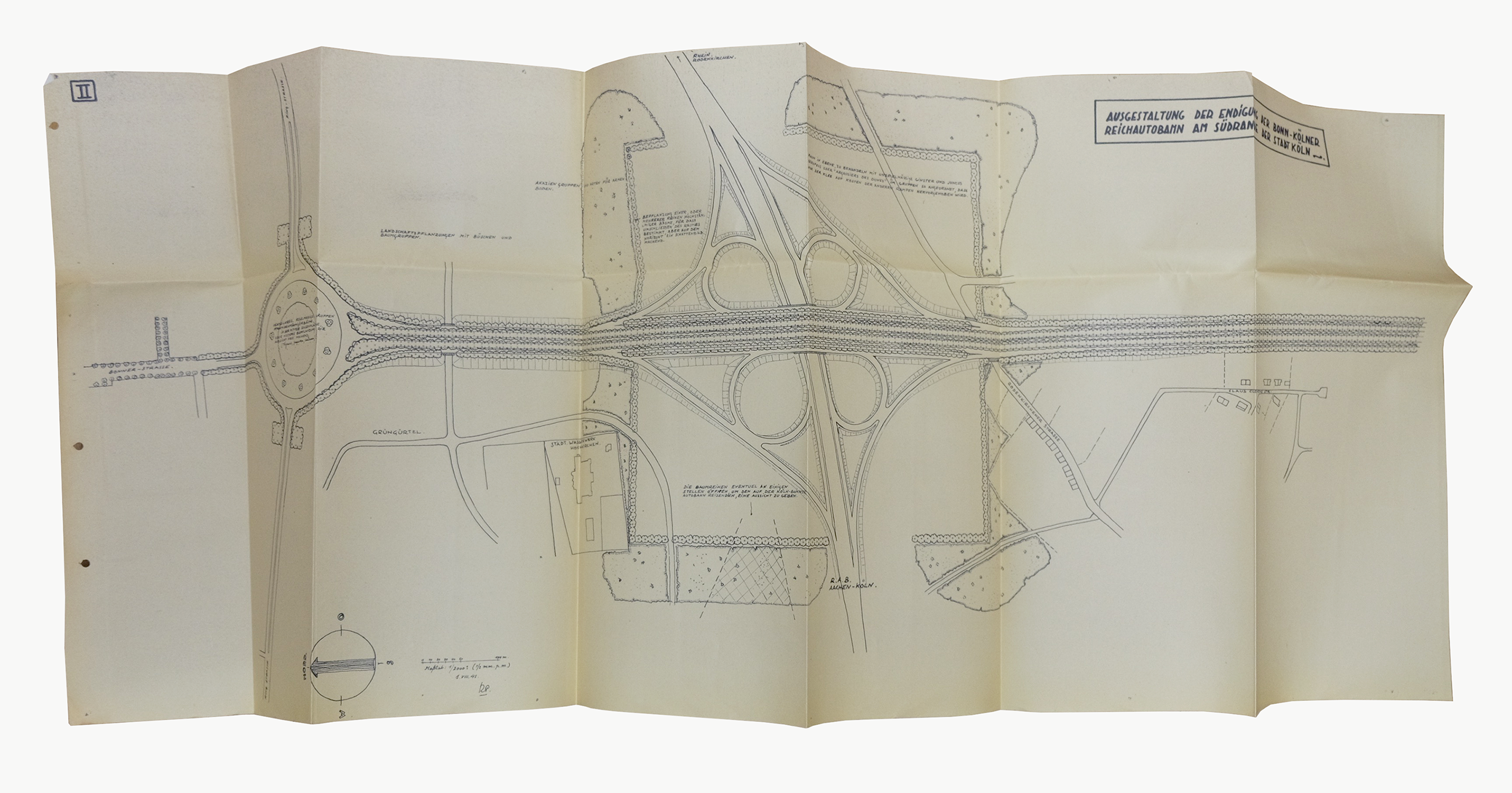
Cloverleaf and Roundabout on the Rechsautobahn Bonn – Köln. The intersection is enclosed in what Pechère calls ‘a geometric space of planting'. (TUM Collections, Alwin Seifert Archive).
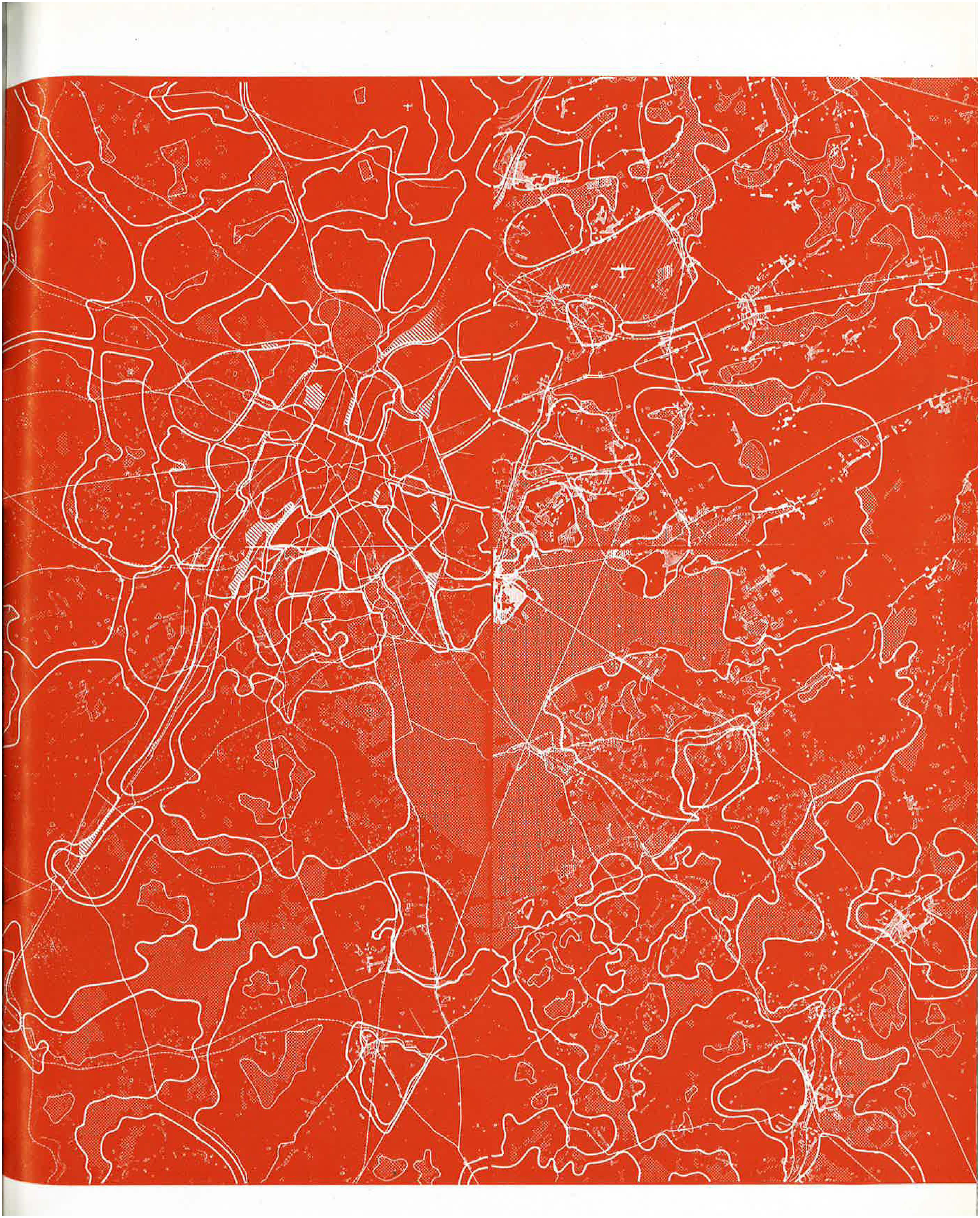
The regional plan for green spaces for Brussels, part of the first Alpha Plan. Pechère drew a grid layout in which green spaces could grow between functional zones (Pechère, 1959).

Four excerpts from the second Alpha Plan. On the top left: a drawing of the space needed to maintain ‘biological equilibrium'; Top right: a drawing of the Brussels topography; Bottom left: a drawing of the Brussels areas in need of green spaces; Bottom right: a drawing of the ‘network of green tentacles' (CIVA Collections, René Pechère Archive).
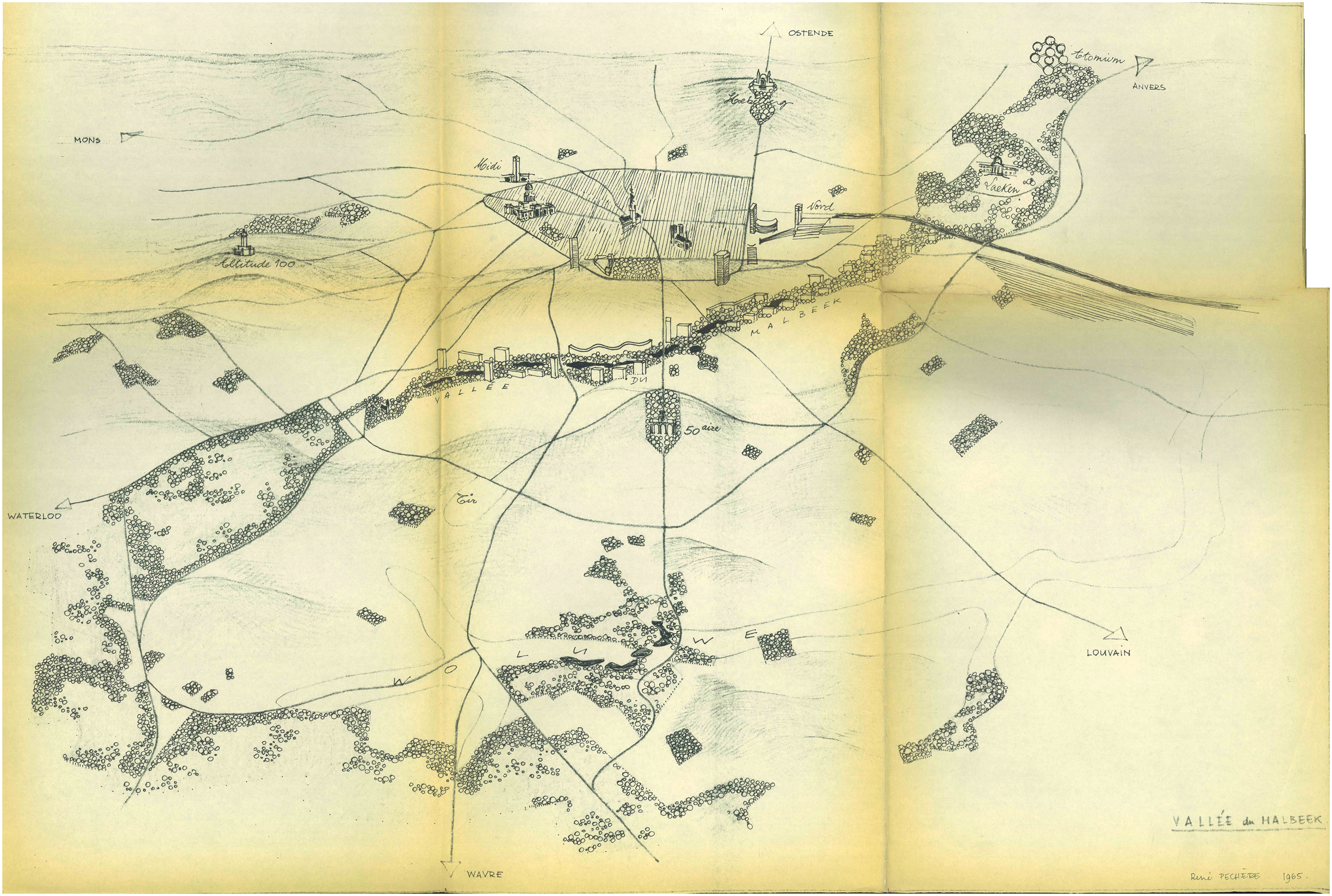
Study of the Maalbeek Valley in Brussels showing the inner city in the background. The nineteenth- and twentieth-century city belt is depicted as an empty space intersected by green infrastructure. The diagonally shown Maalbeek Valley is renaturalized, with high-rise buildings placed on its slopes. 1965 (CIVA Collections, René Pechère Archive).
Footnotes
Funding
The authors disclosed receipt of the following financial support for the research, authorship, and/or publication of this article. This work was supported by the University of Antwerp, KU Leuven, Fonds Wetenschappelijk Onderzoek (grant number FFB160224, Impuls ECOLOG, V434822N).
