



Abstract
Local knowledge plays a central yet uneven role in climate change policymaking. Drawing on the concept of climate eco-governmentality, this paper examines how interactions among actors, knowledge, and scales shape the governance of mangrove ecosystems in the Colombian Caribbean. Building on critical climate change and political ecology scholarship, I analyse how knowledge produced by local communities, public institutions, and academic actor's gives rise to climate change geographies marked by collaboration, conflict, frictions, and scalar encounters and mismatches. Based on empirical research in Cispatá Bay and the La Virgen and Juan Polo Marsh, the paper shows that locally grounded forms of knowledge—emerging from long-standing territorial defence, racialized histories of dispossession, and everyday care ecosystem practices—have challenged state-led conservation frameworks and reshaped national understandings of mangroves. This entangled and uneven history reveals how public policies in Colombia have been reconfigured through multi-scalar encounters, shifting from viewing mangroves as controllable natural resources to recognising them as socio-ecological systems situated at the centre of climate governance and territorial defence debates.
Introduction
Climate change governance is not a neutral process but a contested field shaped by struggles over knowledge and spaces. In August 2023, I attended the Sixth International Conference on Mangrove Macrobenthos and Management (MMM6) under the theme “Mangrove Ecosystems for Human Wellbeing on a Changing Planet” after visiting Cispatá Bay and interviewing mangleros, 1 and women planting mangroves in Villa Gloria in the north of La Virgen and Juan Polo Marsh, Cartagena, both in Colombia. The conference brought together global experts, institutions, local communities, and governments to discuss the relationship between mangrove ecosystems, climate change, and biodiversity. Once in the conference, I received a call from a leader of Cispatá's mangleros organization. She asked, “How is the conference going? Are they talking about us?” Searching the program for “Cispatá Bay” and “Vida Manglar, 2 ” I noted presentations by the Ministry of Environment, and some researchers. I replied, “Yes, there's some representation,” to which she responded, “We should also be there. The story is going to be incomplete.”
Black and Campesino communities, academics, state institutions, and international agencies play key roles in shaping mangrove governance in the Colombian Caribbean. While much attention to the geographies produced by climate change and biodiversity policies has been dedicated to capturing the differences between scientific and more “local,” “traditional,” or “Indigenous” narratives, often assuming a distinction between a disembodied global science and an embodied situated-local knowledge (Mahony and Hulme, 2018; Ulloa, 2017), the mangroves in the Colombian Caribbean exemplify how actors at different scales have shaped climate change policies and geographies in a contested interplay. Then, rather than being neutral or purely technical, climate and biodiversity policies have long been embedded in political struggles over land, water, forest and knowledges. Hence, this paper seeks to understand: how do interactions among different forms of knowledge shape the spatial production of climate change governance? More specifically, I examine how these interactions materialize in what I call climate change geographies, that is, the uneven, contested, and spatially differentiated outcomes of climate governance.
Accordingly, the aim of this paper is to examine specifically how locally produced knowledge contributes to the re-politicization of climate change policies, generating climate change geographies marked by contradictions, frictions, dialogues, and possibilities that ultimately transform the uses and meanings of the ecosystem. I understand re-politicization as the process through which conflicts, negotiations, and contestations -interplays- over knowledge and territory become visible and reshape environmental governance. Using the concept of climate eco-governmentality (Ulloa, 2005), I argue that the interactions between different kind of knowledges related to mangroves in the Colombian Caribbean exemplify how the relations among mangroves, people, biodiversity, and climate change were shaped through a complex interplay between knowledge and scales related to this ecosystem. I use interplay to describe the dynamic, and often unequal, interactions through which actors, knowledges, and scales confront, negotiate, and reconfigure environmental governance.
Using the cases of Cispatá Bay and the mangrove women collectives engaged in ecosystem care in La Virgen and Juan Polo Marsh (Cartagena), I examine how knowledge emerging from processes of territorial defence led by Black and Campesino communities has shaped the ways public policies define and govern the relationships among mangroves, people, biodiversity, and climate change. To do so, I trace the entangled history through which mangrove governance in Colombia shifted from a framework centred on state control and surveillance to one that increasingly frames mangroves as socio-ecological systems within climate change debates. More than a linear policy evolution, this shift reflects ongoing negotiations, conflicts, and alignments among actors operating across scales. In this sense, I show how interactions between local, technical, and institutional forms of knowledge materialize in specific governance practices, producing uneven and contested climate change geographies. These dynamics are particularly visible in the development of policies related to climate adaptation and mitigation, including those associated with emerging blue carbon market schemes, where different understandings of the ecosystem continue to be negotiated and disputed.
Mangroves are coastal ecosystems consisting of trees growing in brackish waters or intertidal areas of tropical regions (Kathiresan and Bingham, 2001; Leal and Spalding, 2024). Key species include black mangrove (Avicennia germinans), red mangrove (Rhizophora mangle L.), white mangrove (Laguncularia racemosa), and Zaragoza mangrove (Conocarpus erectus) (Alvarez-León and Polania, 1996). Adapted to extreme conditions like high salinity, water fluctuations, and low soil oxygen (Simard et al., 2019), mangroves act as natural barriers against storms and erosion, while their roots trap sediments and create coastal soils (Simard et al., 2019; Wetlands International, 2019). They, also, store up to four times more carbon per unit area than other tropical forests (Maxwell et al., 2023) and support high biodiversity (Duke, 2017). Socially, mangroves sustain Black, Indigenous, and Campesino communities, who depend on them (Dirección de Asuntos Marinos, Costeros y Recursos Acuáticos, 2023; Quiroga Manrique and Caretta, 2025). Given multiple uses and adaptability, mangroves have been subject to various meanings and practices throughout history. While traditionally valued for wood production and fishing, they have recently gained attention for their role in carbon sequestration and climate change-related projects (Global Mangrove Watch and Global Mangrove Alliance, 2021; Song et al., 2021).
In the Colombian Caribbean, mangroves are found in rural areas and urban outskirts, historically housing Black, Indigenous, Campesino, and fishing communities (Blanco-Libreros et al., 2022; Dirección de Asuntos Marinos, Costeros y Recursos Acuáticos, 2023). The ecosystem faces varying conservation statuses due to degradation from pollution, urbanization, agriculture, and tourism (Alvarez-León and Polania, 1996). Specifically, the degradation of mangroves in the Colombian Caribbean has been linked to processes of land grabbing, urbanization, and other extractive activities (Berman Arévalo, 2017, 2019; Ojeda, 2012, 2016). One of the activities that has most affected the ecosystem is the expansion of agricultural and livestock frontiers (López-Angarita et al., 2016), which brought violent processes of land and water grabbing that have displaced local communities to the remaining mangrove areas or outside of degraded zones used for expanding agricultural production.
Then, the Colombian Caribbean has been profoundly shaped by violence and land and water dispossession, concentrating 28.38% of all victims of the armed conflict (over 2.7 million people) despite representing only 22.75% of the national population. The forced displacement of more than 2.1 million residents between 1994 and 2010 dramatically transformed rural and coastal territories, including mangrove ecosystems such as Cispatá Bay and La Virgen and Juan Polo Marsh, where Black, Indigenous, and Campesino communities have long sustained their livelihoods (Comisión de la Verdad, 2022). This violence has been deeply racialized, affecting nearly 518,000 members of ethnic groups whose territorial knowledge and practices are central to mangrove governance.
Considering this context, and the need to examine how environmental governance is produced within an ecosystem that is both critical to climate change and deeply shaped by histories of dispossession and violence. I draw on the idea that mangroves constitute a new climate change geography—one through which it is possible to trace the histories of transformations, struggles, and forms of labour and care that have shaped an ecosystem now situated at the centre of disputes over climate governance, biodiversity, and territorial defence (Quiroga Manrique and Caretta, 2025).
To narrate this entangled history, this paper is organized as follows: first, I outline the theoretical framework using the concept of climate eco-governmentality (Ulloa, 2005) as a foundational idea to related knowledge, scales and geographies production. Then, I recount the state of mangroves in the Colombian Caribbean, and their connection with the climate change policies. Subsequently, I present general methodological considerations. As results, I include a section that narrates the entangled history of policies related to the knowledge of Black and Campesino communities. Finally, I present the discussion and general conclusions.
Climate eco-governmentality: Knowledge and politics of scale
Climate change is not a neutral or purely natural process but a historically and politically constructed phenomenon (Borras et al., 2022; Ekowati et al., 2023; Paprocki, 2021; Paredes and Kaulard, 2023; Sultana, 2022) that produces uneven geographies rooted in colonial and capitalist relations of power (Knox, 2020; Mahony and Hulme, 2018). Understanding climate change therefore requires analysing the ways in which knowledge, discourses, and material practices interact to shape the spatialities and temporalities through which environmental governance operates. Building on Ulloa's (2005, 2012, 2015; 2014) concept of climate eco-governmentality, I approach climate change as a field of power where environmental policies and politics, scientific frameworks, and local knowledge(s) and practices converge to regulate, use and organized nature. Climate eco-governmentality refers to the ensemble of discourses, knowledge regimes, and practices that guide social actors toward specific environmental ends, producing new forms of territorialization and subjectivity (Ulloa, 2005). Hence, the concept of climate eco-governmentality enables an analysis of the forms of knowledge and practices connected to climate change, unveiling their roots and the knowledge regimes underpinning adaptation and mitigation projects, especially those involving ecosystems such as mangroves (Paprocki, 2021). The concept thus provides a powerful analytical lens to understand how climate change governance materializes spatially producing what I refer to as climate change geographies.
From this perspective, climate change geographies are not merely physical or ecological outcomes, but the spatial expressions of power relations embedded in climate governance. I argue that climate change geographies are a result of the interplay of knowledge, practices, texts, and discourses that transform and produces spaces and generate new ways of life (Brace and Geoghegan, 2011; Eriksen et al., 2015; Mills-Novoa et al., 2020). Then, climate change geographies are not neutral environmental phenomena but materialized through contested processes: “still-contested geographies”. Climate change geographies are produced rather than given. There, climate governance, local struggles, and environmental and climate justice intersect in shaping the space (Quiroga Manrique and Caretta, 2025).
To analyse how climate change geographies are produced through the lens of the concept of climate eco-governmentality, two analytical elements are key for this paper: knowledge and scale. Knowledge, understood as a cumulative and culturally transmitted set of understandings, practices, and beliefs (Berkes, 2012; Horowitz, 2015), becomes central to this process. From a Foucauldian perspective, knowledge is inseparable from power, as it is produced, legitimized, and contested within specific institutional, political, and historical contexts (Foucault, 1980). As Ojeda (2014) observes, the various forms of knowledge associated with climate change translate into practices, behaviours, and policies that ultimately create a geopolitics of knowledge with material effects on how territorialities of adaptation and mitigation are reconfigured. Yet, following recent debates in critical ocean and climate governance (Champion and Strand, 2025), climate eco-governmentality also draws attention to the ambivalent and contested interplays between knowledge systems, rather than assuming that “integration” of local knowledge is a straightforward or harmonious process. Instead of treating knowledge incorporation as an additive endeavour, this approach highlights the frictions, negotiations, and asymmetries through which knowledge circulates and acquires authority. In this sense, climate change geographies are shaped through the interplay of knowledge systems, discourses, and practices that both reflect and reproduce global asymmetries in environmental governance (Champion and Strand, 2025; Ulloa, 2017).
Scale, for its part, is not a fixed or pre-existing spatial framework but a socially produced and dynamic process through which power circulates and is reorganized (Neumann, 2009; Smith, 1992). Processes of rescaling, for instance, translating global climate imperatives into local adaptation or mitigation projects, reveal how climate governance operates through spatial differentiation and scalar negotiations. Through this lens, climate change geographies emerge as the material and discursive outcomes of climate eco-governmentality: they are formed through the interplay of knowledge, practices, and actors that redefine territories, govern ecological relations, and structure the interactions between the global and the local (Swyngedouw, 2004; Turner, 2006).
I focus on processes of territorial defence led by local communities as concrete expressions of how knowledge materialized through everyday practices and political engagement that generate contested spaces/territories and reconfigure socio-ecological relations. These processes reveal that local knowledge is not only a set of adaptive practices but also a political resource through which communities articulate claims over territories, 3 land, labour, livelihood, and environmental governance. In this sense, the defence of mangrove ecosystems becomes a spatial and political practice through which local actors contest dominant forms of environmental management and produce alternative territorialities that challenge the logics of state and market control.
Mangroves in the Colombia Caribbean
In the Colombian Caribbean, mangrove degradation—driven by pollution, urban expansion, tourism, and the advance of agricultural and livestock frontiers—has severely altered the ecosystem (Barrera-Bello et al., 2025). These environmental pressures are intertwined with land grabbing, extractive activities, and violent territorial transformations that have displaced Black, Indigenous, Campesino, and fishing communities from their historic coastal and wetland territories spaces (Camargo, 2020; Sánchez-Cuervo and Aide, 2013; Suarez et al., 2018). Murillo-Sandoval et al. (2022) report that Colombia lost 47,937 hectares of mangroves (14.4% of the total surface) between 1984 and 2020. Since the 1940s, 57% of Colombian mangroves have degraded, mostly in the Caribbean, reducing from 500,000 hectares to 213,857 (López-Angarita et al., 2016). Due to deforestation and degradation, mangroves have diminished their capacity to provide ecosystem services and ecological functions (Dirección de Asuntos Marinos, Costeros y Recursos Acuáticos, 2023) At the same time, they have become highly contested ecosystems among local actors who depend on their services.
Hence, despite the degradation, mangroves remain a backbone for Black and Campesino communities which use them to procure food, fish, and construction materials for homes (Casas Monroy, 2000). Reichel-Dolmatoff (1965) documents that settlements in the mangroves, specifically in the Colombian Caribbean, are linked to histories of diaspora and slavery. Black communities in the Colombian Caribbean, especially those near Cartagena and the Gulf of Morrosquillo in Cispatá Bay, mention that their ancestors were connected to the mangrove. Local communities argue that the history of mangroves cannot begin at any other moment than the process through which enslaved Black communities settled in the mangroves (Zapata Olivella, 2020) and began to share the territory with Indigenous and Campesino communities already present there (Fals Borda, 2002). Then, mangroves were and continue to be spaces of refuge, nourishment, habitation, and sites of resistance, ecological care, and social reproduction (Quiroga Manrique et al., 2026).
The case studies of La Virgen and Juan Polo Marsh in Cartagena, Bolívar, and Cispatá Bay in San Antero, Córdoba (see Figure 1), highlight the dynamic relationship between mangrove ecosystems and different forms of knowledge in the Colombian Caribbean. In one hand, La Virgen and Juan Polo Marsh, a coastal lagoon essential for Cartagena's ecological structure, faces challenges from urban expansion, pollution, and tourism, yet remains central to Black communities like Villa Gloria. Here, mangroves have historically served as a refuge and resource amid land disputes and racialized marginalization. Recent restoration projects, led by local women, blend local knowledge and technical expertise to reclaim territorial rights and adapt to climate change (Quiroga Manrique et al., 2026). In this case, dialogues with institutional and international actors have focused on collective land titling for Black communities, and the implementation of participatory processes has been limited to environmental compensation initiatives. On the other hand, Cispatá Bay, a protected mangrove area since 2006 and now, part of a voluntary blue carbon credit market project called Vida Manglar, is an example of how knowledge at the local level has transformed and influenced the implementation of conservation and restoration projects linked to national and international biodiversity and climate change policies. In this case, the daily and embodied work of mangleros has managed to position local knowledge as a vital element in the construction of climate change policies and geographies by positioning community-based labour as vital for the conservation of the ecosystem's biodiversity within climate change policies.

locations of the case of studies. Own Elaboration.
Methods
Between 2022 and 2024, I conducted document analysis and interviews with actors involved in mangrove governance in the Colombian Caribbean. As a Colombian researcher pursuing a PhD in a Scandinavian institution, my positionality shaped both access to the field and my relationships with different actors. Access to institutions and international organizations was facilitated by the recognition of my host institution, while engagement at the local level was grounded in shared language, national identity and previous dialogues and encounters. Having this in mind, the study draws on three main sets of data. First, I reviewed fourteen national policy documents, laws, and decrees, as well as five international policy texts, and carried out five interviews with national government officials. Second, I conducted five interviews with academics engaged in producing technical assessments and implementing conservation and climate-related policies in the region. Third, I conducted ten interviews with leaders from mangrove communities in Cispatá Bay and from Black organizations in the La Virgen and Juan Polo Marsh, focusing on knowledge grounded in everyday, embodied engagements with the mangrove.
To analyse these materials, I adopted a multiscalar approach attentive to the ways in which environmental governance is produced through interactions across actors, practices, and discursive formations (Del Cairo et al., 2015). Rather than treating scale as a fixed administrative category, I understand it as a relational and permeable dimension, constituted through the circulation of knowledge (Neumann, 2009; Smith, 1992). Accordingly, when organizing the data by actor, level, and year of production, the “scale” attributed to each actor reflects the reach and mobility of their discourses and practices, recognizing, for instance, how national policy is simultaneously shaped by international agendas and local mobilizations, and how local actors often draw on national or global framings.
In total, the dataset includes 19 documents and 19 interviews. Policy documents were directly coded, and interviews were fully transcribed; all sources were originally in Spanish, with relevant excerpts translated into English for analytic purposes. The analysis was guided by questions concerning understandings of mangroves, practices of care, and the relationship between climate change and biodiversity. These questions oriented the examination of how changing interpretations of mangrove ecosystems have shaped, and been shaped by, their position within broader climate policy debates.
Climate eco-governmentality in the Colombian Caribbean
To narrate the entangled history of mangrove governance in Colombia, I outline three moments that trace how diverse actors—local communities, state institutions, academics, and international organizations—have shaped, contested, and reconfigured the management of these ecosystems (see Table 1). This history highlights the multi-scalar interactions through which knowledge and power relations have produced climate change geographies marked by long-standing degradation. These intertwined trajectories show how governance processes have produced contested geographies, shaped by both exclusions and strategic alignments across scales. They also underscore the central role of Black and Campesino communities in challenging these dynamics, asserting territorial claims, and contributing to the ongoing reconfiguration of mangrove governance in the Colombian Caribbean.
Three moments in the production of climate change geographies in the Colombian Caribbean (1970–2022). Own elaboration.

State control (1970–1990)
Following the Ramsar Convention on Wetlands in 1975, which highlighted the importance of preserving wetland ecosystems and the UNESCO World Heritage Convention of 1975 that stressed the cultural value of mangroves, the first Colombian laws on mangrove conservation emerged in the 1970s. Working alongside the National Institute of Renewable Natural Resources and the Environment (INDERENA), the earliest national institutional definitions positioned mangroves primarily as water resources. Within this framing, promoting responsible fishing became central due to the ecosystem's role in supplying food and wood. Decree 1681 of 1978 was the first national institutional document addressing mangrove conservation. It is important to note that no data exists prior to 1960 that would allow for an assessment of the state of the mangroves (López-Angarita et al., 2016). This decree emphasized conservation and responsible use of hydrobiological resources, viewing mangroves primarily as food providers, after a long history in which mangroves did not even appear in public policy and were seen as unproductive and uninhabited spaces (López-Angarita et al., 2016).
Following this first decree and reinforcing the idea of national control over the ecosystem, Decree 2324 of 1984 was promulgated by the Ministry of Defence. This decree regulated the action of the military forces in marine sectors, ports, and other water spaces. With this decree, mangroves were defined as objects of state protection and public use. This indicates that mangroves were integrated into a centralised control system led by the national government. Today, DIMAR (Colombian Maritime Authority) continues to exercise control over mangrove ecosystems and currently plays a key role in reporting crimes associated with the illegal logging, controlling fishing vessels, and participating in discussions on territorial and maritime planning.
Although the first laws concerning mangroves emerged in the 1970s, and the earliest data on their conservation status dates to the 1960s. Local communities, such as the Caño Lobo mangrove association in Cispatá Bay, had long relied on the ecosystem for sustenance, building homes, and other needs. One of the leaders of the association in Cispatá Bay said, “We have been here for a long time because the slaves who had the opportunity to escape would go to the mangroves, in these places, this is where we, as Black and Campesino people, could live.” In these ecosystems and their surroundings, local communities territorialised their daily life, making the ecosystem central to the reproduction and production of life. These claims are supported by archaeological and archival records showing that mangrove areas in the Colombian Caribbean and Pacific have been inhabited since pre-Columbian times, and that one of the principal uses of these forests has historically been the extraction of wood for construction (López-Angarita et al., 2016).
Regarding the military control process over the mangroves and the disruption of local relations, Don Gabriel, 4 a manglero from Cispatá, comments, “Between 1960 and 1973, Los mangleros still lived in the mangrove canals, because there we could manage our economy. We collect only what we need, not what we want” That means that, despite the control, the legislation encountered a territorial resistance process based on sustainable practices of care and knowledge at the local level. Thus, amid controversies, this first moment is characterised by local communities defending their territorial rights from mangrove management legislation that did not yet recognise the historical connection between communities and mangroves (see Figure 2). López-Angarita et al. (2016) also point out that Colombia—like several other countries in the region—did not include legislation specifically addressing ecological value and their long-standing relationships with local communities during this early period. On the contrary, mangroves were widely regarded as potentially productive land to be controlled.

First moment: state control (1970-1990). Own elaboration.
This first moment is therefore characterized by an emerging and incipient national institutional framework concerning mangroves, one largely oriented toward their military control. This occurred in parallel with the rise of international agreements in which these ecosystems began to be framed as key spaces within debates on heritage and biodiversity. At the local level in the Caribbean, meanwhile, mangroves remained historically inhabited by Black and Campesino peoples who relied on them primarily for construction materials, housing, and fishing. Thus, one of the roots of contested climate change geographies in the Colombian Caribbean begins with the incorporation of mangroves into state-controlled spaces, where the state, backed by international treaties, was called upon to reassert authority over these ecosystems.
Biodiversity and Black and Campesino communities (1990–2000)
In Colombia, the 1990s began with a constitutional reform that established the right to a healthy environment as a fundamental right. This shift strengthened environmental institutions and opened the way for the ratification of key international treaties governing ecosystems such as mangroves, including the Convention on Biological Diversity (CBD) in 1993. As a result, the Ministry of Environment—created by Law 99 of 1993—adopted principles aligned with biodiversity protection. These principles were translated into national regulations, some of which prohibited the local use of mangroves, particularly the extraction of mangrove wood for timber. At the national level, environmental governance was reorganized through the creation of the National Environmental System (SINA), a multi-level institutional framework composed of national authorities, a network of Autonomous Regional Corporations (CARs), organized by river basins, and research institutes such as INVEMAR (Institute of Marine and Coastal Research), among others. This structure consolidated the State's capacity to regulate, monitor, and plan ecosystems, reinforcing a centralized and technical approach to environmental management.
This new institutional framework produced new regulations to the management of mangroves mainly connected to biodiversity schemas. Most of the specific regulations were issued in the mid-1990s, focusing on planning, monitoring, control, and surveillance of mangroves (Dirección de Asuntos Marinos, Costeros y Recursos Acuáticos 2023) (see Figure 3). For example, in the resolution 1602 of 1995, mangroves were understood as conservation areas where interactions with humans were not necessarily the centre of sustainability processes. Their value was, therefore, purely biological related to their biodiversity. At the community level, specifically in the Caribbean, in the Bay of Cispatá, this understanding of mangroves kept affecting local livelihoods and labour. As Doña Ignacia de Rosa, a member of the mangleros in Cispatá, mentions, this law prohibited the logging of mangroves that the communities in this area were historically undertaking. She mentions that the prohibition came with arguments related to the ecosystem value of mangroves: “That's when the CVS (Regional Corporation of the Valley of the Sinú River) and INDERENA came out saying there would be no more permits to use the mangroves because they were saying the world is warming and we need to take care of the forest… That's when they banned the cutting of mangroves by a resolution”.
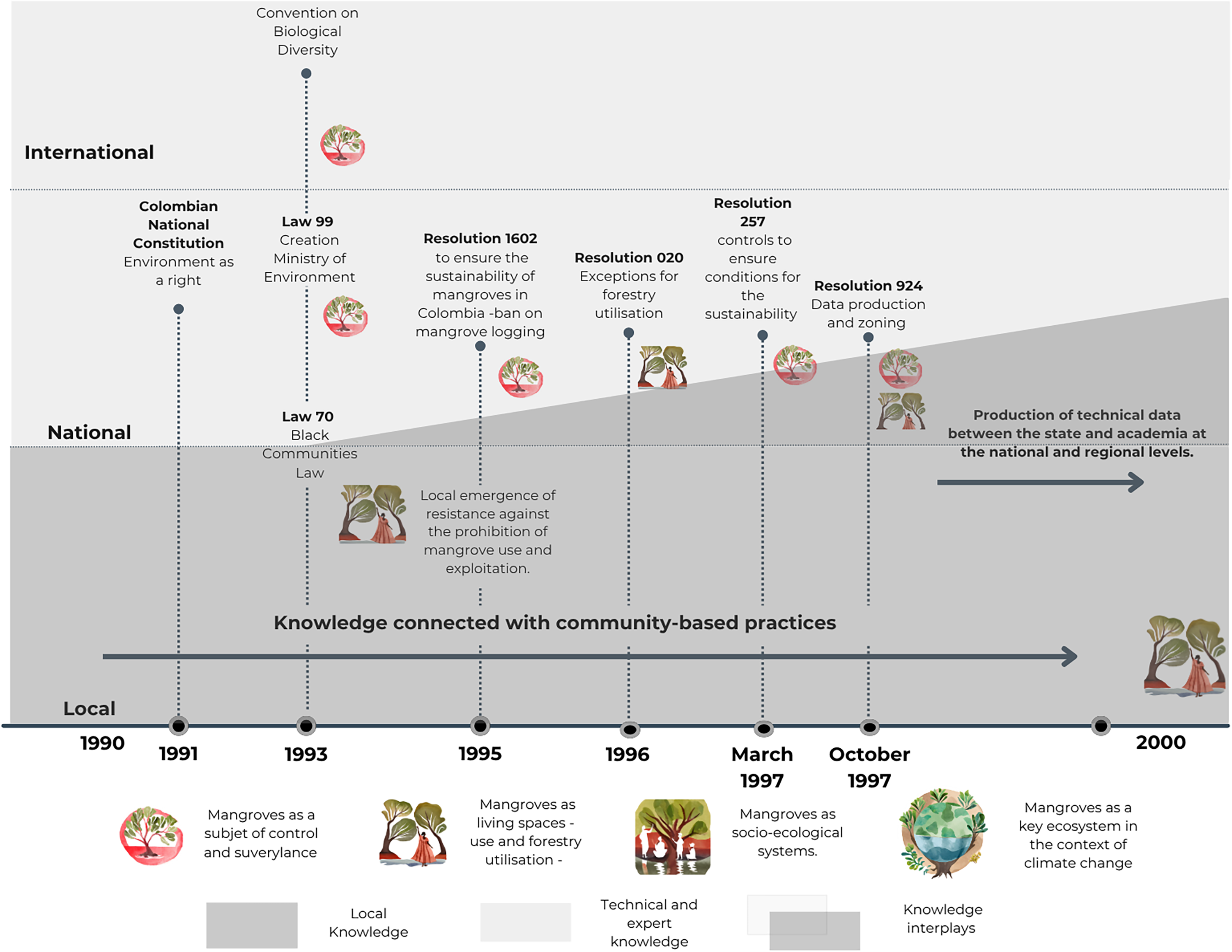
Second moment: biodiversity and Black and Campesino communities (1990–2000). Own elaboration.
A key feature of the early 1990s is that the implementation of biodiversity-oriented legislation—aligned with emerging international conservation frameworks—translated into national prohibitions that were rapidly contested and reworked locally and nationally. Laws restricting mangrove use, especially bans on logging, clashed with the everyday practices, labour and livelihoods of Black and Campesino communities who depended on mangrove forests for construction, fishing, and subsistence. These prohibitions triggered different forms of local response: in places such as La Virgen and Juan Polo Marsh, Black communities mobilized the newly established Law 70 on Black Communities to defend their territorial rights and challenge exclusionary conservation mandates; while in Cispatá Bay, mangleros negotiated directly with regional environmental authorities, asserting the legitimacy of their knowledge and practices to preserve the biodiversity and the mangrove itself.
As a result, the logging prohibition were claimed, resisted, and reported locally by various communities along the country. In Cispatá, the mangleros continued lobbying local authorities to reclaim their rights to use and manage the mangrove ecosystem. Meanwhile, at the national level, Black communities mobilized in the wake of Law 70 of 1993, 5 demanding that the government guarantee the territorial rights they had secured in earlier years. After discussions at regional and national levels, The Ministry of Environment issued the Resolution 020 of 1996, clarifying that forestry use of mangroves could be allowed, but it must be done through the regional autonomous corporations that are responsible for enforcing environmental legislation. Then, the communitarian contestation at different scales was based on an initial process of reshaping environmental policies connected with biodiversity, seeking to integrate important daily activities, and labour for local life reproduction and production.
Nationally, the Law 70 of 1993 known as the Black Communities Law is a key element for understanding the territorial defence processes undertaken by local communities. This law based on the understanding that mangroves in Colombia are common goods owned by the State, decreed that the State must recognise the Black communities that occupy these ecosystems. This law, the result of mobilisation, complicated the conservation landscape of natural spaces like mangroves and allowed Black communities to reclaim or at least begin to dispute their presence and territoriality in these ecosystems. Through this law, Black communities demonstrated that mangroves are part of Black history and, therefore, must be part of the communitarian spaces.
However, the implementation of this law has taken different forms and has responded to varying Pacific and Caribbean struggles. In the Caribbean, some communities, such as La Boquilla and Villa Gloria at the La Virgen and Juan Polo Marsh, opted to claim their territorial rights to mangroves under this figure of community councils for Black Communities. There, the struggle for territorial defence began in the mid-nineties, and there is still no guarantee of collective land titles that would allow the Black communities of Cartagena to make use of the mangroves or their territories; however, in Cispatá Bay, although the population recognises itself as Black communities, they preferred, according to their leaders, to continue negotiating with the regional autonomous corporation to guarantee their rights to territory and the use of the mangrove. Locally, in Cispatá Bay, the negotiation took place because a joint documentation space promoted between the local communities and regional corporations, where locally produced knowledge was essential for any intervention in the bay. Don Jose mentions, “We started documenting ourselves and began telling people, no, but we should look for or create a law that protects us… we have rights, we talked about territorial rights, about where people lived”. Both the debates related to the Black Communities territorial rights in Cartagena and the forestal use of mangroves derived from territorial rights in Cispatá Bay occurred in a process where technical laws (Resolution 1602 of 1995 and Resolution 020 of 1996) were the legal basis for control, planning, and management of the mangrove ecosystem.
Thus, the first part of the 1990s marks a pivotal moment in which key interactions and negotiations between local communities and state institutions, shaped by emerging international agendas, began to redefine mangrove governance. Prohibitive approaches, grounded in the ecological and technical logics of biodiversity preservation, were challenged by localized forms of territorial defence and knowledge-based claims to inhabit and use the ecosystem. Hence, by the mid-1990s, two political trajectories converged: one that framed mangroves primarily as ecological assets to be protected through technical regulation, and another that understood them as lived, socio-ecological spaces central to Black and Campesino histories. These trajectories placed mangroves at the centre of environmental debates from two directions, one rooted in conservationist control, the other in the defence of life and territory, laying the foundations for the contested climate change geographies analysed in this paper.
These dynamics intensified with the promulgation of two additional resolutions in the latter half of the 1990s: Resolution 257 of March 1997 and Resolution 924 of October 1997. Both emerged within a national context in which environmental institutions were seeking to address growing concerns over mangrove degradation. Developed almost in parallel, these legal instruments reveal how Black and Campesino communities shaped debates over the meaning of conservation. The first resolution focuses primarily on the biotic dimensions of mangroves, while the second explicitly addresses the economic activities of local communities within the ecosystem. In this sense, local practices of defending mangroves as historical and inhabited spaces were central to the emergence of legal frameworks that began to recognize the relationship between people and mangroves as essential for biodiversity conservation.
In Resolution 257 of March 1997, mangroves were understood as a forest without people that needed to be protected from degradation. In that resolution, the only mention concerning the community was related to the requirement for prior consultations in case projects changed land uses. Doña Ignacia from Cispatá debating: “But how are they going to tell me that my mangroves are disappearing when they’re still there. I’m there every day, and there are more mangroves each day. I got a little upset. I started losing my patience.” In contrast, Resolution 924 of October 1997 -produce just seven months later- included for the first time in the debate the necessity of mangrove zoning that encompassed previous uses and affected communities, for which studies on the ecosystems were needed.
This resolution, which, as mentioned, was shaped by some of the debates promoted by Black and Campesino communities in their defence of their territories, was a first step in the later definition of mangroves as socio-ecological systems that emerged in the 2000s. Tied to the need to identify the current state of the mangrove ecosystem in its diversity, Resolution 924 of 1997 ordered the CARs to issue management and zoning plans for mangroves within their jurisdiction on a regional scale. These plans, among other things, had to include mapping of actors, zoning of areas for the use or veto of economic activities, historical maps of degradation processes, and other elements. This meant that the resolution obligated regional authorities to generate data and knowledge on the condition of the mangrove ecosystems and their people. Despite the legal call, the development of these research and documents was not carried out in detail or fully in all regions. For example, in the Cispatá Bay, the documentation was made in a collaboration between the CAR and mangleros communities. In contrast, in La Virgen and Juan Polo Marsh, the CAR acted as a technical institution and locally, Black communities did not feel part of the discussion. This means that data production about mangroves has developed unevenly. In La Virgen and Juan Polo Marsh, this process fundamentally focused on producing technical data associated with coverage, general degradation status, biodiversity issues, and the recovery capacity of mangroves. In contrast, a more participatory approach that involved mangleros as knowledgeable stewards of the territory was carried out in Cispatá Bay.
In the Colombian Caribbean, individuals connected to academia, such as Heliodoro Sánchez-Páez and his collaborators, were key in this process. The team led by him, a forest engineer, within the framework of a national project called the Mangroves of Colombia Project (MCP), funded by the International Tropical Timber Organization (ITTO), and coordinated by the Ministry of Environment and the Colombian Association of Forest Engineers, constitutes the largest inventory of mangroves at the national level (Álvarez-León et al., 2021). All this data was collected and compiled in the mid-1990s and has since provided the most significant amount of open data used by the government for ecosystem planning processes. It is key to mention that Heliodoro Sánchez-Páez, besides being a university professor and involved in research, was also the director of INDERENA. This institute began controlling and characterising mangroves.
Mangleros in Cispatá were very important in this data production process locally and its connections to the communitarian work. Don Alfonso comments that before the institutions arrived to implement the research and the management plans, they had already started the data collection and the restoration, as a form of ecological care and sustainable engagement with the mangrove: ‘We started it ourselves without anyone telling us it was restoration or monitoring. We called it cleaning the canals, recovering the canals. Caring for the mangroves” During the 1990s, several academics involved in mangrove planning worked in the area, including the Heliodor Sánchez-Páez team, focusing on sustainable management of mangrove wood, some amphibian species, and generally on tourism-related topics. During these years, groups of mangleros continuously trained, creating management and organisation projects for mangroves that would later be reflected in the subsequent publication and declaration of the integrated management district (DMI acronym in Spanish) of the Cispatá Bay. As some of the founders of the mangleros association comment, the joint work was based on the idea that there was no one better than the mangleros to care for mangroves because they are the ones who know the mangroves. Doña Ignacia comments: “They came in to do studies, so we agreed with the communities to start talking about what we wanted to achieve with those studies and how we would collaborate. Our conclusion is the mangrove allows us to use it so that we can, and we know how to take care of it.”
During this second moment (1990–2000), especially in Cispatá Bay, a series of relationships were consolidated between local knowledge and practices with the intervention of academics and other institutions that entered the territories with a perspective aimed at including communities in their stewardship. In contrast, in Cartagena—particularly in the surroundings of La Virgen and Juan Polo Marsh—local knowledge became shaped by territorial defence processes unfolding along the northern margins of the marsh. While in Cispatá the interplay and re-politicization of mangrove knowledge emerged through dialogue and collaborative work among academia, state institutions, and mangleros, in Cartagena the interplay was more contested and centred on struggles for territorial rights. In La Virgen and Juan Polo Marsh, technical knowledge about the ecosystem prevailed within institutional debates, whereas at the local level the struggle focused on securing land titling and the recognition of Black communities as key actors in the Marsh and in the care and use of the mangrove.
This implies that the implementation of national laws did not unfold uniformly at the local level, and the incorporation of local debates occurred in highly uneven ways. While the case of Cispatá illustrates a process in which community knowledge was part of the discussion into mangrove assessments—supported by a strong role for academic actors—the interplay between Black communities in Cartagena and environmental institutions was far more fraught. In this context, environmental governance processes ultimately excluded local claims to land and the recognition of Black communities as territorial actors, reinforcing long-standing inequalities in access to decision-making and environmental policy.
This second moment (1990–2000) must be understood in relation to the first one, when mangrove governance in Colombia was defined primarily through military control and their classification as uninhabited, strategic border ecosystems. Against this backdrop, the early 1990s marked a profound institutional shift: the constitutional recognition of the right to a healthy environment and the creation of a national environmental framework aligned with emerging international biodiversity agendas. This new institutional landscape produced regulatory regimes that rapidly collided with the daily practices, territorial histories, and socio-ecological relations of Black and Campesino communities. The uneven responses to prohibitions on mangrove use illustrate how climate eco-governmentality began to take shape through multi-scalar negotiations, exclusions, and alliances. These interplays show that mangrove governance was never solely institutional but emerged from frictions and convergences between technical, legal, and locally embedded knowledge. Together, these dynamics constituted the second foundational layer in the production of contested climate change geographies, setting the stage for the next moment in which climate adaptation, mitigation, and blue carbon markets would further reconfigure the environmental governance.
Climate change (2000–2022)
The third moment of this entangled history of mangrove governance in Colombia relates to how mangroves are integrated first into land-use planning and then into climate change policies, which have become relevant due to the increasing frequency of extreme weather events and the increase in international policies associated with mitigation, particularly blue carbon market schemes.
In relation to land-use planning policies, at the national level, from the 2000s onwards, based on the data produced in the 1990s, Colombian environmental institutions issued several administrative acts focusing on creating regional regimes for using mangroves (see Figure 4). At that time, Decree 3600 of 2007 established guidelines for rural and urban planning, emphasising the integration of strategic ecosystems. However, the planning process remained the responsibility of regional, municipal, and departmental authorities, so although the law was national, its application had to be made at regional level.

Third moment: climate change (2000–2022). Own elaboration.
In this regionalisation process, it is worth highlighting the work undertaken by the mangleros of Cispatá. In this place, a joint effort between local communities, academics, and regional environmental management institutions agreed that regional sustainability needed to include forest uses within land-use planning while restoring, conserving, and generating joint management plans. These dialogues resulted from territorial defence processes in the 1990s, culminating in 2010 with the proposal of the Integrated Management District (DMI acronym in Spanish) (Rojas Giraldo and Sierra Correa, 2010). The DMI's Integral Management Plan was developed through Cooperation Agreement No. 92 of 2007 between CVS and INVEMAR. This document was preceded by technical guides and ecosystem diagnoses. In these documents, the relationships between climate change, biodiversity conservation, community participation, and local contestations are already evident and formed the basis for the multi-scale negotiation.
However, the negotiation that took place in the Cispatá Bay was not replicated in other parts of the Caribbean, where communities continued to be side-lined from land-use planning, use, and management of the ecosystem, as is the case in the La Virgen and Juan Polo Marsh in Cartagena. Land-use plans for the La Virgen and Juan Polo Marsh were prepared by professionals contracted by the regional environmental authority, CARDIQUE. These plans took the form of highly technical documents in which community participation was limited to consultation mechanisms, prioritizing the production of technical knowledge rather than fostering substantive community dialogue. This dynamic was shaped by the fact that debates over territorial rights and collective land titling for Black communities were still ongoing at the time, constraining the extent to which local claims and local forms of knowledge could be meaningfully incorporated.
There, the regional planning process occurred unevenly and addressed diverse forms of territorial defence in each mangrove area in the Caribbean. These scalar encounters and mismatches demonstrate how, in different places, the interplay among actors produced distinct institutional responses regarding the management and knowledge production of mangrove ecosystems. The incorporation of mangroves into land-use and territorial planning policies became a decisive moment for observing how such interplays materialized: in contexts where local dialogues occurred, planning processes reflected negotiations over the uses and meanings of the ecosystem, whereas in other locations this incorporation reinforced exclusionary practices and even the criminalization of local communities.
Eight years later mangroves became protagonists of national policies again, in conjunction with international climate change treaties. Despite since the 1990s several academic studies had already noted that mangroves play a key role in climate adaptation processes, by 2018, new land-use laws emerged in the national landscape that mention mangroves as strategic ecosystems for climate change adaptation and mitigation. The Ministry of Environment, through Resolution 1263 of 2018, updated specific measures to guarantee the sustainability and integral management, adjusting the mangrove planning and adopting three instruments: the “Guidelines for Mangrove Ecosystem Restoration in Colombia,” the “Guidelines for Mangrove Monitoring in Colombia,” and the “Information System for Mangrove Management in Colombia – SIGMA” (Minambiente, 2017).
These guidelines involved the participation of former Deputy Minister of Environment Sandra Vilardy (2022–2023), who knew and worked closely with the process in the Cispatá Bay and other regional mangroves in the Caribbean. This is noteworthy and shows the relevance to integrate laws regarding mangroves that consider biotic and social components as intertwined. In these guidelines, the social component “includes the inhabitants and users of mangrove services, their distribution in the territory, the activities they carry out, and the organisations and institutions that influence it” (Vilardy et al., 2014). Although these guidelines addressed some of the problems associated with the uneven regionalisation, the comprehensive application of policies has begun to be recognised. These instruments, partly due to the territorial defence led by Black and Campesino communities and due to the emergence of climate emergencies (for example, the 2010 floods caused by the La Niña phenomenon) in different parts of the country, prompted the inclusion of social components and the need to think locally about climate change adaptation and mitigation.
Thus, these three documents share two important characteristics that, using some local experiences as examples, such as the Cispatá Bay, are key to understanding how local knowledge and practices also contributed to the construction of national policies. These elements reflect the influence of both international frameworks and locally grounded processes, revealing how policy is constructed through multiple perspectives that often appear contradictory in practice. The first characteristics relates to understanding mangroves as socio-ecological systems. The definition of mangroves in Resolution 1263 of 2018 is stated as: “Mangroves correspond to a socio-ecological system, in which the natural component and the social interact and have evolved together, since practices such as fishing, gathering crustaceans and molluscs, hunting, wood extraction, fuel wood and medicinal plants, and transportation, among other activities carried out in these areas, have woven close and indivisible links between the natural and the social.” (Resolution 1263 of 2018)
A second characteristic of these guidelines is that they reflect an international push to develop global instruments for climate change mitigation and adaptation. They emerged following Colombia's 2005 ratification of the Kyoto Protocol, which emphasized mangroves as critical ecosystems for carbon capture due to their role in the global carbon cycle and CO2 absorption. Mangrove conservation also addresses deforestation, a major source of greenhouse gas emissions. The 2015 ratification of the Paris Agreement further reinforced this focus by setting Nationally Determined Contributions (NDCs) for emission reductions, highlighting biodiversity protection and wetland conservation as priorities for countries with these ecosystems.
With the ratification of these two international agreements related to climate change, what happened in places like the Cispatá Bay was that local struggles seeking to understand the complementarity of mangroves with ways of life began an intense dialogue with ecosystem conservation projects tied to international strategies such as REDD+. As is commented locally, what allowed this plan to be developed collaboratively, without erasing the inequalities in the hierarchy between technical knowledge and knowledge from the local scale, was that: “In 2015, that's when they started with the study that had been done on carbon credits. Many mangleros participated. We then began to talk about REDD+, the impacts, and all of that. That's when the process of CI (International Conservation) came in, along with Fundación Omacha, and then INVEMAR and CVS followed, as well as the older mangleros. Yes, those of us who have lived here our whole lives.” (Doña Ignacia de la Rosa, Fieldwork, 2023, March 12, personal communication)
However, other social organisations globally criticised these solutions for considering them market-based and untrue -false- solutions to structural problems (Hoz et al., 2024; Moreano Venegas et al., 2022; Plataforma Latinoamericana y del Caribe por la Justicia Climática, 2021, 2022). Organisations such as the World Rainforest Movement and the Global Forest Coalition argue that these solutions are implemented in territories that have been previously dispossessed and affected by extractive projects, producing new inequalities and depriving communities of their rights (Global Forest Coalition, 2021; World Rainforest Movement, 2022). They also argue that nature-based solutions, especially those associated with REDD + projects, do not overcome the market logic that commodifies nature. Moreover, these solutions risk further dispossessing local communities of their territories and ways of relating to nature, as they do not consider local contexts and will transform everyday life (Onta et al., 2021). Civil organisations also argue that these solutions will endanger the rights of Indigenous, Black, and Campesino communities. In Latin America specifically, some regional platforms indicate that the so-called green solutions are racist, patriarchal, and colonial and that they only deepen historical and gender inequalities (Acción Ecológica, 2021). Within this context of controversies and multi-scalar dialogues, places like the Cispatá Bay managed to consolidate participation and contestation processes where local communities feel represented, especially the mangleros.
In the current phase of global mangrove governance, the emergence of Vida Manglar as a blue carbon project places Cispatá Bay within a growing global trend that reframes mangroves as “natural capital” for carbon accounting. While the longstanding interplay among mangleros, academics, and regional institutions in Cispatá has produced a multi-scalar encounter—one in which local knowledge has effectively shaped restoration practices and ecosystem management—blue carbon schemes introduce new risks that echo critiques raised in the wider literature (Song et al., 2021). As global carbon markets privilege technocratic, accounting-oriented approaches, they risk sidelining the complex social relations, mixed livelihood economies, and customary forms of tenure that have historically grounded mangrove stewardship in Cispatá. The emphasis on carbon metrics may displace or overshadow the relational, socio-ecological understandings of mangroves that local communities have defended for decades. Thus, even in a place where collaborative governance has been relatively strong, blue carbon projects threaten to recentralize decision-making, narrow the scope of legitimate knowledge, and reconfigure power in ways that could erode the very encounters between scales that enabled Cispatá's governance model to emerge.
In this final moment (2000–2022), it becomes evident that the uneven ways in which policies materialize across territories reveal scale as a permeable and relational process rather than a fixed administrative framework (Neumann, 2009). In Cispatá Bay, the articulation between mangleros, academics, and regional institutions fostered a multi-scalar dialogue that enabled local knowledge to shape ecosystem management, even in the implementation of climate change projects such as those linked to blue carbon schemes. This ambivalent scalar alignment made it possible for local practices of labour, care and restoration to be recognized within regional and national policy frameworks, contributing to the emergence of an alternative governance model grounded in the interplay of technical expertise and local knowledge. By contrast, the case of Villa Gloria and the La Virgen and Juan Polo Marsh illustrates what happens when local knowledge is excluded and criminalized. Here, climate and biodiversity policies were implemented without meaningful participation, reinforcing longstanding racialized hierarchies and producing new climate injustices (Quiroga Manrique et al., 2026). These exclusions catalysed territorial defence efforts through which Black communities contested the narratives and interventions imposed on the ecosystem. Together, both cases demonstrate that the politics of scale shapes not only which knowledges count, but also whose practices and territorial claims become legible within climate policy.
Discussion: Entangled histories in the production of climate change geographies
The findings of this paper show that climate governance in Colombian Caribbean mangrove territories emerges through entangled and contested interactions between actors, knowledge, and scales. The cases show how scale is not a pre-given hierarchy but a relational effect of political struggles, which explains why similar policies materialize so differently across territories. A scalar reading of the production of climate eco-governmentality and its resulting geographies allows to understand how the inclusion and exclusion of specific forms of knowledge generate linkages and tensions through scalar mismatches and alignments. Through these processes, local knowledge materializes in concrete practices of care, labour and defence in the implementation of public policies (Ojeda, 2014; Ulloa, 2005, 2017). Rather than unfolding through linear policy implementation, the production of climate eco-governmentality materializes through frictions, alignments, and disconnections that reveal the relational and contested nature of knowledge and the space production. This perspective highlights that climate change geographies are not pre-given environmental outcomes but produced through socio-political processes where knowledge circulates unevenly, shaping the spatialities of climate governance.
This means that in the practice and materialisation of climate eco-governmentality there can be policy materialisation processes where dialogue and frictions enables collaborative work between different knowledge and territorial disputes, as seen in Cispatá Bay, or cases where local knowledge is excluded, leading to climate injustices that are subsequently contested through processes of territorial defence as in the case in Cartagena. Therefore, recognising the interplay between different knowledge at different scales is key to understand the production of climate change geographies.
This implies that climate eco-governmentality in the Colombian Caribbean is characterised by contestation processes among different actors, where knowledge related to territorial defence and local use of the nature has permeated and brought to the discussion the need to include local communities in conservation processes, but above all, in the inclusion of mangrove geographies in climate change debates. To illustrate these processes, in this discussion, I highlight two key elements for understanding the production of climate change geographies and the associated policies: first the process of reconfiguring mangroves as socio-ecological systems and secondly the relations between climate change and biodiversity.
The reconfiguration of mangroves as socio-ecological systems emerged through a series of negotiations among different actors across multiple stages of national policy development, in which locally produced knowledge played a crucial role. It was only through the inclusion of territorial struggles and the preservation of local practices that the definition of forests as systems independent of communities was subverted, leading to an understanding of mangroves as a socio-ecological system. The national recognition of mangroves as socio-ecological systems was not simply a technical shift in environmental legislation but the outcome of long-standing struggles by Black and Campesino communities. The redefinition of mangroves—from objects of state control to socio-ecological systems—emerged through decades of negotiation, conflict, and collaboration. For example, in places like Cispatá Bay, mangleros’ local knowledge of mangrove uses, seasonal cycles, and labour practices challenged state-centric understandings of the forest as a biological entity separate from human life.
The interplay between national policies and local struggles for mangrove defence, grounded in a dialogue between local and scientific knowledge, transformed how this ecosystem is understood. This transformation was driven by the national mobilization of Black communities in the Colombian Pacific and Caribbean and local efforts in areas like Cispatá Bay, where mangleros defended their territories. These struggles and dialogues shifted mangroves from being seen as objects of control to socio-ecological systems vital for understanding human-mangrove relationships. This shift enabled, at least theoretically, a less exclusionary management process, though it has not been fully applied everywhere, as illustrated by the case of La Virgen and Juan Polo Marsh in Cartagena. That means that although this recognition enabled more inclusive policy approaches in some territories, it has not been consistently applied across the region. The continued exclusion of local knowledge in the La Virgen and Juan Polo Marsh in Cartagena case reflects the persistent fragility of this socio-ecological perspective and the uneven territorialization of climate change policies.
Regarding the relations between biodiversity and climate change, it is relevant to mention that this relation was established by recognising the relationship between people and mangroves, this means that it was a subsidiary relationship to the recognition of mangroves as socio-ecological systems. This relation did not arise solely from international climate mandates but from local practices of care, labour, and territorial defence. As the results show, Black and Campesino communities framed biodiversity conservation not as a technical domain but as a practice embedded in everyday forms of livelihood, territorial belonging, and ecological stewardship. Throughout these processes, what was achieved was an understanding that climate change should not be seen as a series of timeless impacts; rather, it should be understood as a story in which dispossession (Borras et al., 2022; Ekowati et al., 2023), territorial defence, and local practices are key to the production, care, and maintenance of geographies (Paprocki, 2021). Meanwhile, as seen in the second phase of the historical construction of climate eco-governmentality processes, biodiversity was debated locally, emphasising the necessary care that must be carried out in situ to protect it. The history in the Colombian Caribbean shows that climate change and biodiversity agendas cannot be separated, as they represent processes of care and preservation at different levels that ultimately apply to a single territory locally understood in its entirety and integrally with local communities.
What this story about the interplay between different knowledges and scales demonstrated is that the consolidation of the relationship between local communities with the State—and, at the same time, the relationships between the State and international agendas—occurred through processes of contestation, participation, and exclusion based on diverse knowledge and integrated scales in the materialisation of geographies. In Cispatá Bay, for example, the articulation occurred through the inclusion of ideas about labour, sustainable use and ecosystem care, while in Cartagena, local struggles involved identity and historical processes of reclaiming mangroves as part of the communities’ history. In this way, the battle over the meaning and management of the mangrove is ongoing as well the design and implementation of public policies connected to climate change.
Conclusions
In conclusion, I argue that across both cases, climate eco-governmentality emerges as a field marked by uneven power relations, where knowledge circulates asymmetrically and produces diverse geographies. In Cispatá Bay, institutional and community interactions produced a model of governance grounded in sustainable use, restoration, and multi-scalar collaboration and friction. In Cartagena, however, the exclusion of local actors from planning processes reinforced the marginalization of Black communities and intensified territorial struggles.
The analysis of the evolving legal framework and public policy documents, together with interviews related to the processes of including mangroves in Colombia's Caribbean region in national and international climate change policies, allow for an examination of how knowledge emerging from local processes of contestation and the territorial defence managed, in these specific cases, to influence the definition of mangroves and the necessary connection between climate change and biodiversity. The case of mangroves in the Colombian Caribbean demonstrates how climate eco-governmentality remains a helpful concept for understanding how locally produced knowledge is partially included or excluded in constructing public policies that transform daily lives. In this way, this paper contributes to critical climate change literature produced within human geography (Mills-Novoa et al., 2020; Nightingale et al., 2022; Sultana, 2022), as it presents a case where policies, knowledge, scales, and actors produce uneven geographies that require greater attention, given the proliferation of such dynamics in strategic ecosystems around the world (Song et al., 2021). While much scholarship on climate governance emphasizes the production of climate injustices, this analysis shows that the climate change geographies in the Colombian Caribbean are also shaped by forms of territorial struggle and knowledge-making that actively reconfigure environmental governance. Local knowledge is not only a tool for adaptation but a political resource through which communities assert territorial rights, challenge extractive interventions, and shape how climate change is narrated and governed.
This perspective expands understandings of climate geographies by situating them within the lived histories of violence, displacement, and ecological care that characterize mangrove territories. In this sense, climate change geographies are produced through everyday territorial practices that contest and reshape state and market logics, revealing the limits of top-down interventions and the transformative potential of local knowledge.
This study shows that climate policies become re-politicized precisely when local and institutional knowledges meet through conflict and negotiation. By tracing the historically entangled processes through which mangrove governance emerged in the Colombian Caribbean, the analysis demonstrates that climate eco-governmentality materializes unevenly: sometimes through collaborative alignments that reflected territorial knowledge into national frameworks, as in Cispatá Bay, and other times through exclusionary processes that generate climate injustices and intensify territorial contestation, as in the La Virgen and Juan Polo Marsh. These cases reveal that the production of climate change geographies cannot be divorced from the histories of land struggles, racialized inequalities, and forms of local stewardship that shape how ecosystems are governed.
Finally, recognizing the spatial and scalar dimensions of environmental governance is therefore essential for understanding how climate policies are negotiated, contested, and transformed. The Colombian cases illustrate that the circulation of knowledge across scales is neither linear nor harmonious; it is structured by power relations, historical dispossession, and differentiated access to institutional arenas. Yet it is precisely through these frictions and encounters that public policies become re-politicized: local actors mobilize embodied, place-based knowledge to assert territorial claims, challenge technical framings of conservation, and push for socio-ecological understandings of mangroves that reconfigure national climate agendas. Like a kaleidoscope, the climate change geographies integrate contradictions, dialogues, and encounters between different forms of care, labour, control, and management of a contested ecosystem, such as the mangroves in the Colombian Caribbean. This demonstrates that climate governance is not simply implemented but produced through spatialized negotiations that shape the resulting climate change geographies.
These insights extend beyond the Colombian Caribbean and offer valuable lessons for environmental governance in other regions. As ecosystems such as mangroves, wetlands, and forests become increasingly central to global climate strategies, acknowledging territorial histories, local knowledge systems, and multi-scalar power dynamics becomes crucial for preventing new forms of exclusion and climate injustice. The findings underscore that effective and equitable climate governance depends on integrating local practices of care, territorial defence, and socio-ecological understandings into climate policy debates. In this sense, the Colombian case demonstrates that re-politicizing climate policies through local knowledge is not an obstacle to global climate agendas; it is a necessary condition for producing more just, contextually grounded, and ecologically meaningful climate futures.
Highlights
The paper shows how climate eco-governmentality emerges unevenly through multi-scalar encounters between local, institutional, and scientific knowledges in the Colombian Caribbean.
The research demonstrates that locally grounded knowledge—rooted in territorial defence, racialized histories of dispossession, labour, and everyday care—has reshaped national understandings of mangroves.
The paper provides a historically grounded analysis revealing how governance shifted from controlling mangroves as natural resources to framing them as socio-ecological systems central to climate debates.
The study reveals that climate change geographies in Cispatá and Cartagena are produced through conflicts, frictions, alignments, and mismatches that re-politicize climate policies.
Finally, the study offers broader insights for global climate governance by showing that equitable climate futures depend on acknowledging territorial histories, power relations, and the political role of local knowledge.
Footnotes
Acknowledgments
I thank the mangrove communities of the Bahía de Cispatá and the women mangrove planters of the Villa Gloria community in Cartagena. Thank you for sharing your time and knowledge about the mangroves of the Caribbean. I also appreciate the officials from the environmental authorities in both places for telling me about their work. I appreciate the comments from the Feminist Political Ecology reading group, especially Ingrid and Margarita. I also thank Martina Angela Caretta for her constant feedback and support, as well as Torsten Krause and Valentina Lomanto for their contributions.

Ethical approval
This research received approval from the Swedish Ethical Review Authority, with the approval decision issued on February 27, 2023.
Funding
The authors disclosed receipt of the following financial support for the research, authorship, and/or publication of this article: This research is part of my doctoral research process, funded by the Department of Human Geography at Lund University, Sweden.
Declaration of conflicting interests
The authors declared no potential conflicts of interest with respect to the research, authorship, and/or publication of this article.