
Abstract
The transformation of rivers has been part and parcel of human history and its development. While often portrayed as ‘the’ way towards development through modernization, these transformations often entail river commons’ enclosures and the loss of related environments and cultures. In this article we explore how in the subregion of Canal del Dique in Northern Colombia, the river has changed through the construction of infrastructure, mainly in the form of canals and dikes that control the rhythmic changes of the water levels in the vast floodplains of the Magdalena River. Through these infrastructural interventions the pattern of an annual flood-drought succession has been curtailed, transforming riverine territories and related ecosystems, societies, lives and cultures. Building on an adapted notion of the Riverhood framework, we analyse how these infrastructural interventions bring with them the enclosure and transformation of amphibious cultures that live and depend on the rhythmic cycles of floods and droughts in the floodplains. The latter, we argue, occurs through the subjectification of hydrosocial riverine environments through modernist notions that shape territorial projects aimed at transforming rivers and their societies. Though grassroots responses have tried to halt these transformations, they have by-and-large failed to stop the advancement of a modern tamed and controlled socio-ecological river upon which a large part of society has become dependent.
Introduction
Rivers around the world have been tamed and modified through human interventions throughout history (Hein et al., 2021). Since the 1950's, this process has greatly intensified, damming, diverting, canalizing and polluting rivers around the globe. Most of these transformations have been inspired by modernization ideologies pre-empted on the idea of ‘taming nature’ to facilitate (socio)economic development (Molle et al., 2009). In the process, many societies and related cultures that depended on untamed rivers and their landscapes, have been enclosed, transformed and/or lost (Wantzen, 2024). This brings us to the recognition that river transformations are intrinsically socio-natural and that water, hydraulic infrastructures and society continuously (re)make each other over time and space (Bakker, 2012; Boelens et al., 2016; Linton and Budds, 2014). Based on this central premise, of what amongst others Ross and Chang (2020) have called hydrosocial theory, in this article we analyse how, in the region of Canal del Dique in northern Colombia, the river and its’ society have transformed since the arrival of the Spanish colonizers. Our analysis focuses on how taming the river hydrology, which was characterised by a strong flood-pulse regime (Junk et al., 1989), has enclosed and transformed riverine lives, livelihoods and cultures. The flood-pulse is defined as the seasonal flood/drought dynamics that shape the landscape of riverine floodplains through large periodic variations in water, sediments, organisms and nutrient flows between terrestrial and aquatic environments (see Grundy-Warr and Lin, 2020, Junk, 2001; Junk et al., 1989).
This paper aims to answer the following question: In which ways does the Riverhood framework advance our understanding of the hydrosocial dialectics that have enclosed amphibious cultures in the region of Canal del Dique in Northern Colombia?
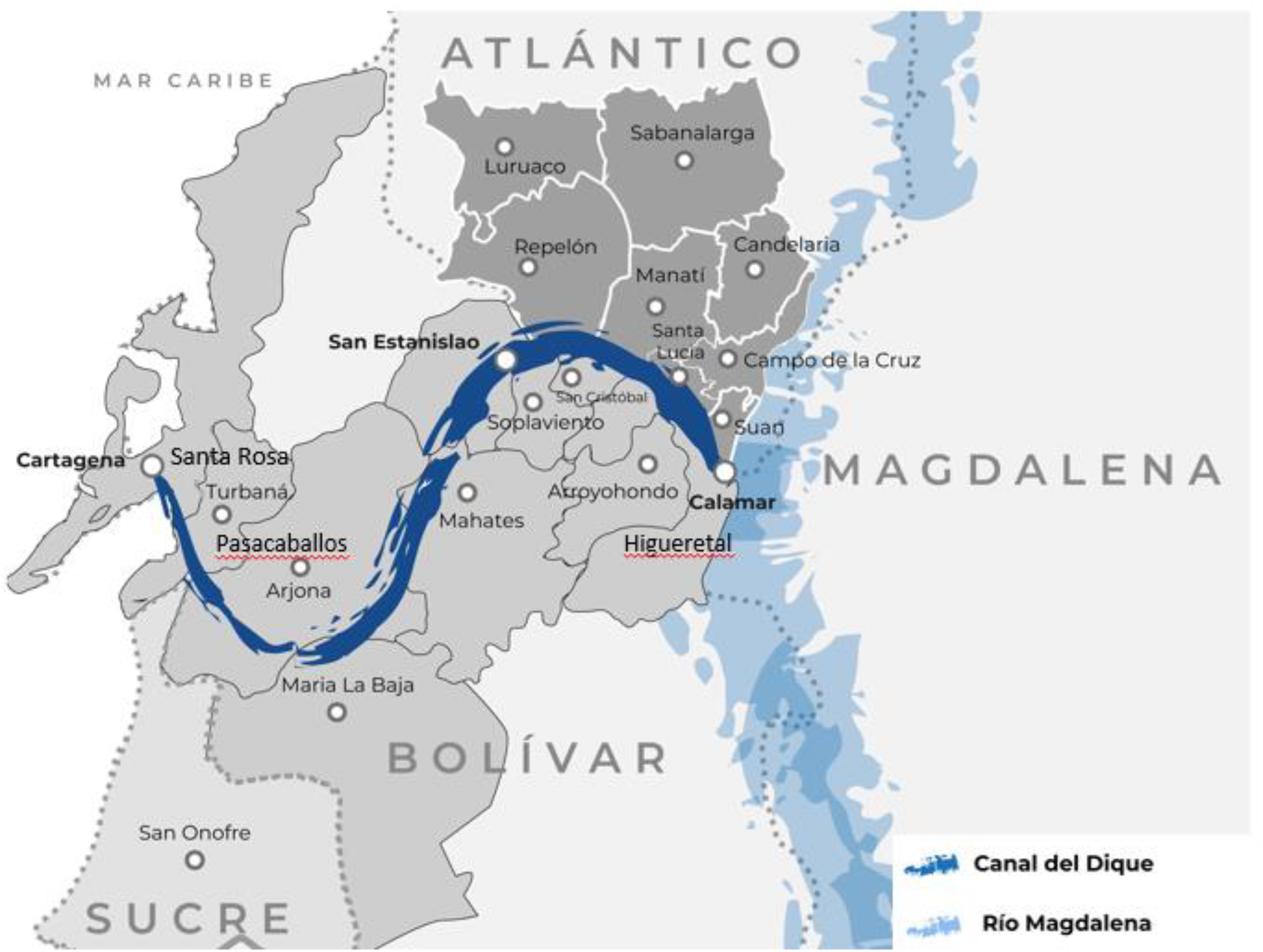
The empirical material that informs our analysis of this case study was collected between May and August 2022 by the first author as part of his MSc Thesis research. The research is based on qualitative research methods aimed at better understanding the socio-natural relations of fishers and farmers and their transformation in the area of Canal del Dique. It consisted of interviews and field observations combined with an analysis of secondary sources including (i) scientific literature; (ii) publications in the news; and (iii) governmental publications. In total 29 unstructured and semi-structured interviews were recorded and analysed. Nineteen interviews were conducted with fishers, farmers, grassroots NGOs, and extension workers. These interviews were supplemented with five interviews with people representing governmental agencies (National Infrastructure Agency (ANI), Cormagdalena and Cardique), and three interviews with project engineers of consultancy firms Herencia Ambiental and Royal Haskoning DHV. Additionally two academics with research experience in the area were interviewed. In the sampling of interviews as well as for field observations, research was done in communities at the start, middle, and end of Canal del Dique, in the towns of Calamar, Higueretal, Santa Lucia, Repelon, Manati (upper part of the canal), Soplaviento (middle part), and Villa Rosa (see Figure 2). All interviews were recorded with consent and later transcribed in Microsoft Word. After cleaning these transcriptions these were coded and thematized utilizing the ATLAS.ti software, which is tailored for qualitative data analysis. The second and third authors contributed to the conceptualization, set-up and theorization of the MSc thesis research of the first author as thesis supervisors, and have led the conceptualization, structuring, writing and analysis that is set out in this article.
The article is structured as follows. In the following section we theorize and elaborate the notion of Riverhood – the dynamics and nature of river's being - as an analytical tool to understand riverine socio-material transformations. Then we explore how amphibious cultures, framed as a river-eco society, have coexisted with and from the flood-pulse of the Magdalena River in the region of Canal del Dique. Section 4 explores how the region of Canal del Dique has been subjectified through modernizing imaginaries since colonial times. We show how the river, its society and its swamp ecosystems were transformed through hydraulic infrastructures. The latter have been used as the central strategy of the state and private companies to territorialize this area by taming the flood-pulse and turning the floodplains into ‘dryland’ for modern agricultural production and settling a terrestrial culture. These interventions impair the migration of endemic fish species that depend on the flood-pulse; whilst simultaneously transforming and enclosing amphibious livelihoods and cultures. We finish this section with an analysis of the most recent plans for restoring the river and the canal, which focus on preventing floods and further controlling the flows of water and sediments through the river and its lagoons. Finally, we present the social contestations against these restoration plans. In the conclusions we reflect on these transformations through the adapted Riverhood framework.
Based on our analysis, we contend that the adapted Riverhood framework can offer new and exciting analytical entry points to better understand riverine transformations. It does so by explicitly addressing questions related to four different ontologies: how do local communities live, with relate to, and interact with the river in a given moment in time (river-as-eco-society)?; what visions and ideas about what a river is and should become (river-as-subject) inspire the political projects of powerful actors and why?; through which interventions/strategies and hydraulic infrastructures is the river transformed (river-as-territory)?; how are these interventions contested and navigated by local communities and their networks (river-as-movement)?; and finally, how does this lead to new riverine eco-societies and sometimes new subjectifications of the river? Our analysis points at the close interrelations and dialectics that exist between these different dimensions. We propose that these dialectics can best be grasped by making an alliteration to a theoretical Möbius spiral in which these four Riverhood dimensions dialectically co-constitute each other but never return to a same point.
Understanding riverine socio-material transformations through the Riverhood framework
Relational and dialectical thought in relation to water has gained traction in critical geography. In essence it implies that social and material things are and become through their dialectical relation to each other (Bakker 2012, Reyes-Escate et al., 2022; Swyngedouw, 2004). Linton and Budds (2014) take this notion along in their conceptualization of the hydrosocial cycle. With this notion they focus the attention on three key ideas: First that (changes to) water flows have a direct effect on the organization of society, and that the organization of society in turn affects how water flows. This creates a cyclical dialectic process. Second that water and society are related internally as hybrids, recognizing that the properties that constitute a component emerge in function of its relation to other components/things (Swyngedouw, 2004). Finally they point to the fact that “the material properties of water play an active role in the hydrosocial process, sometimes structuring social relations and sometimes disrupting them” (p. 175) with important political and social effects that span over space and time (Loopmans and Hoogesteger, 2024). Building on these and other insights, Boelens et al. (2016) introduced the notion of hydrosocial territories (see also Boelens et al., 2025) adding explicit focus to the spatial dimensions of hydrosocial networks on various time, institutional and geographical scales. This notion highlights the intrinsically contested, dynamic and always in-the-making nature of spatially bound socio-material orders that result form constantly shifting geometries of power that aim to control (to sustain or transform) existing order(s) through territorial projects. Hoogesteger et al. (2016) pointed at territorial pluralism which arises from the fact that ‘divergent views, interests and powers over how specific territories are or should be shaped lead to the coexistence of multiple territorial notions (p.93)”, creating overlapping territorial endeavors across space and time. These diverse territorial endeavors that come from different actors and respond to different interests, often clash with each other, leading to conflicts and confrontations, or to their negotiation with important socio-material consequences.
Upon these notions and insights, and to specifically study and understand rivers, in 2023, Boelens et al., introduced the notion of Riverhood. The concept aims to guide inquiries “into the different ways that rivers are imagined, defined, built, produced, and lived as socio-natural, political-economic, and cultural-symbolic systems (Boelens et al., 2023: 1127–1128)”. A basic premise of this notion is that rivers are not only the confined lines of the main water courses of a river (a line), but that rivers are part of dynamic socio-material landscapes (Skidmore and Wheaton, 2022), in which the social, the infrastructural, and the natural are interlinked, hybridized and co-constituent by, with and through water flows (Hommes et al., 2022; Paranage et al., 2025; Reyes-Escate et al., 2022).
One key element of inquiry that informs the Riverhood framework is the specific attention to the role of riverine movements in (re)shaping rivers. The authors propose to study the following four interrelated dimensions and their interrelations: a) riverine eco-societies, b) the subjectification- and, c) territorialization of rivers by riverine movements, and d) how this relates to the constitution and strategies of riverine grassroots movements. They propose “… to understand the river as a Möbius band, in which the river, societal and non-human actors, and politics, co-constitute each other. […] A river thereby turns from being a noun into being a [hybrid] verb” (Boelens et al., 2023: 1139) that can be understood through the four co-constituted proposed Riverhood dimensions (see Figure 1).
Upon these insights and based on the four dimensions presented in the Riverhood framework, here we turn our attention slightly away from a centered focus on riverine movements and go back to explore the broader hydrosocial dialectics through which rivers are transformed. We do so through a slightly adapted Riverhood framework that allows us to understand how dominant actors such as the state, international engineering firms with infrastructure operators and corporate interests transform rivers, their eco-societies and the grassroots responses that emerge to resist and negotiate these interventions. The four dimensions that inform our analysis are elaborated below:
River-as-eco-society: This dimension aims to examine “the constitution and functioning of riverine socio-natures as a result of the interplay of diverse ecosystems, [hydraulic infrastructures], and human actors (Boelens et al., 2023: 1136)”. This understanding of rivers is premised on the notion that the ‘material’ (water, land, rocks, hydraulic and other infrastructures) and the ‘social’ (human beliefs, cultures, institutions and practices) are interdependent hybrids. It recognizes that changes in the material realm brings about social adaptations and transformations; just as social transformations bring about changes to the materiality of rivers through, amongst others, the construction of hydraulic infrastructures, the adaptation of river beds and embankments, land use changes, and changing fishing patterns. The river-as-eco-society dimension helps to understand ‘what’ a socio-material river is, and how it functions through the constant interaction between its’ social and material components at any given moment.
River-as-subject: revolves around the question of the subjectification of riverine eco-societies. That is, it focuses on scrutinizing how rivers as socio-material entities are known, understood and projected as desired ‘subjects’ (Houart et al., 2025b; Mills-Novoa et al., 2020). These specific ways of knowing, understanding, imagining and advancing desired rivers inform the strategies that aim to transform and govern existing eco-societies (subject-formation) into specific socio-material orders and related practices and relations (see also Duarte-Abadía, 2023). Subjectification is closely related to imaginaries, understood as the worldviews that dominant actors have about how the river as eco-society - both socially as well as materially - was, is, and, most importantly, what it should become (Hommes et al., 2022; Houart et al., 2025a). Based on specific notions of existing eco-societies, dominant knowledge systems, and their related rationale and imaginaries, inform the symbolic creation of a subject not only descriptively, but also and above all prescriptively and performatively (Mills-Novoa et al., 2020). Most dominant imaginaries are informed by strong modernizing notions that rest on the premise that existing eco-societies have to be modernized by ‘harnessing nature’ (Hoogesteger et al., 2023a, 2023b). From this perspective, the imaginaries of those in power and with the capacity to bring about change in a specific eco-society are of special interest to understand river transformations. This Riverhood dimension helps to understand the ‘why’ (the rationale) behind interventions aimed at transforming an existing riverine eco-society. This is done by asking who defines the river as a specific -subject to be- and why?
River-as-territory: aims to understand how different actors (try to) order and control socio-material relations. This dimension analyses the tactics used to affect, influence and control riverine people, water, nature and their relations by asserting control to (re)create a specific ‘socio-material order’ in a geographic area (see Sack, 1986). Territorialization is then, in the words of Rasmussen and Lund (2018), “an ambition, a political compulsion, and a project” (p. 392) aimed at using, in this case, riverine spaces, for specific outcomes through the creation of specific socio-material orders. The latter is translated through the control of nature and people; including their activities and organization (Gurung, 2023). Therefore, most river interventions include norms on how water should flow, where, when and controlled by whom (Boelens et al., 2016, 2025). As further explored in the next section, hydraulic infrastructures play a key role in the territorialization of rivers as these material constructs reorder flows of water, flows of sediments, and flows of people and power. This dimension basically explores ‘how’ (the tactics of) powerful actors advance and materialize their wished-for rivers through different strategies of territorial control.
River-as-movement: focusses on understanding how grassroots movements aim to advance their own riverine imaginaries, interests and practices. These movements very often emerge to resist river transformations advanced by powerful actors that threaten their riverine eco-societies and related forms of life. The creation of alternative riverine knowledges, ontologies and imaginaries that challenge dominant river-subjectification imaginaries is central to the struggles of such movements (Cuevas-Parra et al., 2026). River movements, for example, challenge facts and information of ‘experts’ (Hoogesteger and Verzijl, 2015); they contest institutions and authority (Arbeláez-Trujillo et al., 2026); established cultural gender, race and class divisions (Cuevas-Parra et al., 2026); power relations and dominant systems of knowledge creation (Hidalgo-Bastidas, 2019); and related ontologies (Houart et al., 2025b). In short, river-as-movement aims to understand “by whom, why and how” state- or corporate-led river transformation projects are resisted, contested, and reworked from the grassroots. This reworking of intervention projects defines how these land on-the-ground shaping new hybrid riverine eco-societies (Figure 1).
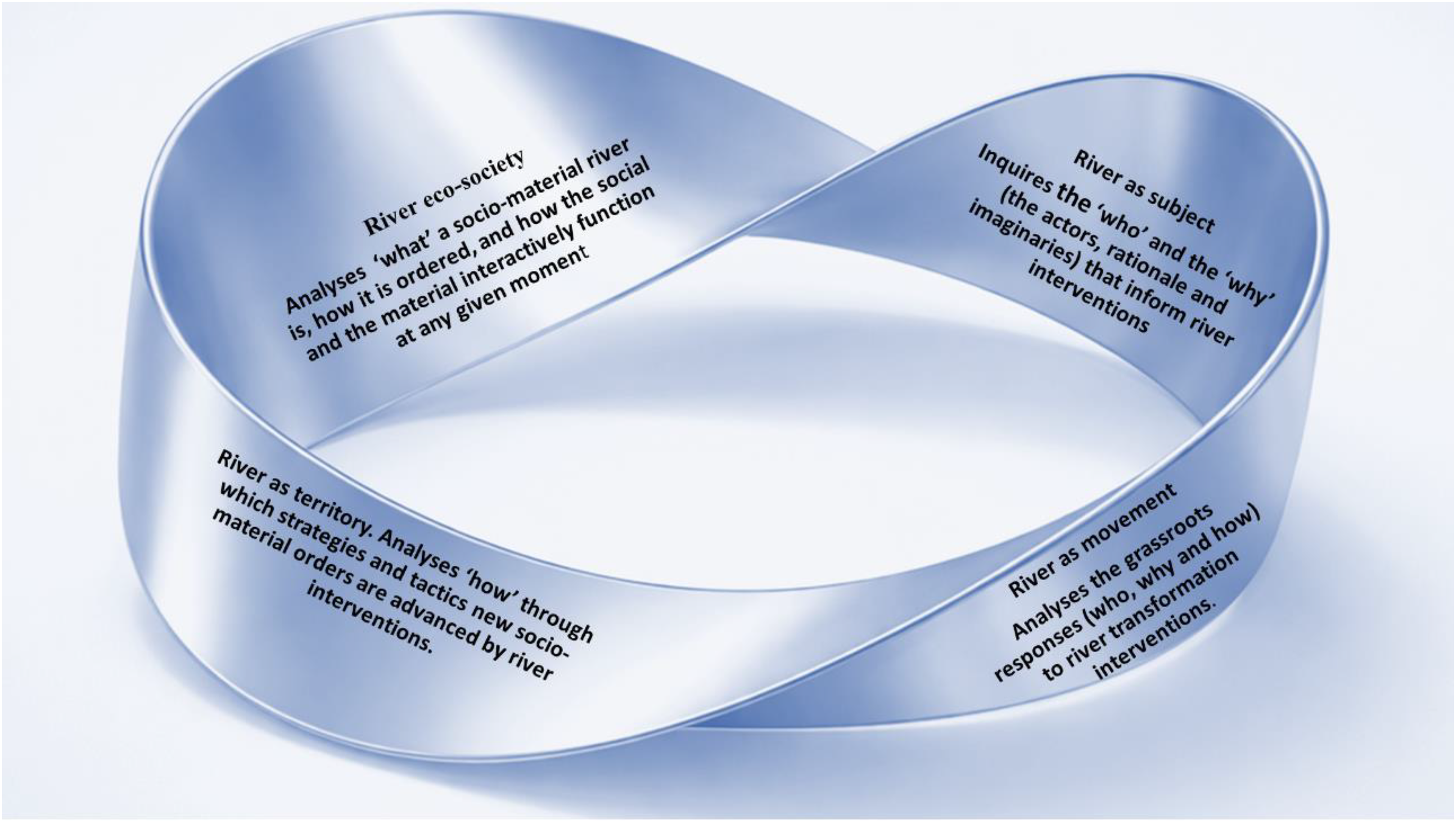
The Riverhood Möbius band (own elaboration).
Infrastructures in the different dimensions of Riverhood
In understanding the dialectics between the social and the material – river as eco-society-, hydraulic infrastructures stand central (Quealy and Paranage, 2024). Through hydraulic infrastructures people harness, control and re-direct water flows in rivers. In its most basic definition, we can conceptualize hydraulic infrastructure as a man-made material object for redirecting and controlling the movement of water (Hommes et al., 2022). Through hydraulic infrastructure people adapt the environment in which they live with consequences for the social relations that revolve in and around water. This recognizes Winner’s (1980) argument that infrastructure -and changes in them- bring about important transformations in patterns of human activity and related institutions (Mirhanoğlu et al., 2023, 2024). Through hydraulic infrastructure, actors transform exiting socio-material orders (river-as-eco society). In other words, they advance a river territorialization project (river-as-territory) that responds to particular interests and understandings of the river (river-as-subject).
Many scholarly contributions have called attention to the politics embedded in- and enacted through- hydraulic infrastructure (Mirhanoğlu et al., 2024; Quealy and Paranage, 2024). Hommes et al. (2022), amongst others, point out the various ways in which hydraulic infrastructures advance territorial projects. This recognizes that river infrastructures are political technologies that bear, ingrained in the designs, the imaginaries and norms of what a river should become (river-as-subject). From this perspective infrastructures are not merely material inert objects but they are prescriptive and performative. As Akrich (1992: 209) states, “the world inscribed in the object is the world described by it.” Infrastructures are the products as well as the producers of social orders (Shah and Boelens, 2021). According to Latour (1991), infrastructures are inscribed with codes about how a certain socio-material order is to be created. These codes are the texts that designers imprint in infrastructure's performative story; telling how the infrastructure is to function, for whom, operated by whom and for what. Through this infrastructural scripting, designers delegate the task of creating and maintaining socio-material orders upon the infrastructure itself through inscribed functions, ethics and values (Latour, 1991: 232). Mosse (2008: 941) therefore observed that hydraulic infrastructures “are ‘political technologies’ – that is, ways of social ordering that themselves influence how people work, relate or produce”. Therefore in our analysis of canal del Dique, infrastructure plays a central role.
River as eco-society: amphibious cultures in the floodplains of the Magdalena river around Canal del Dique
According to Wantzen et al. (2016), rhythmic changes in water levels shape cultural and ecological activities in a vast diversity of rivers around the world. For the Colombian context, in which our case study of Canal del Dique falls, Orlando Fals Borda (1979) coined and used the notion of amphibious culture. This notion “contains ideological elements and articulates psychosocial expressions, attitudes, prejudices, superstitions and legends that have to do with rivers” (p. 21). Here we articulate the notion of amphibious culture to point to cultures in which people carry out their day-to-day activities both on the water as well as on the land according to seasonal patterns. According to Fals Borda (1984), amphibious cultures have adapted to such changing environments by learning how to survive and best utilize intense floods and droughts. They do this by combining fishing with agricultural production adapted to the rhythm of floods and droughts.
The Magdalena River bifurcates into an artificial watercourse known as the Canal del Dique at 100 kilometres before finalising its journey into the Caribbean Sea. This canal is roughly 115 kilometres long and connects the Magdalena with the Bay of Cartagena (Figure 2). The canal serves as the principal fluvial highway for transporting cargo, predominantly hydrocarbons (Bermán y Camargo, 2024).
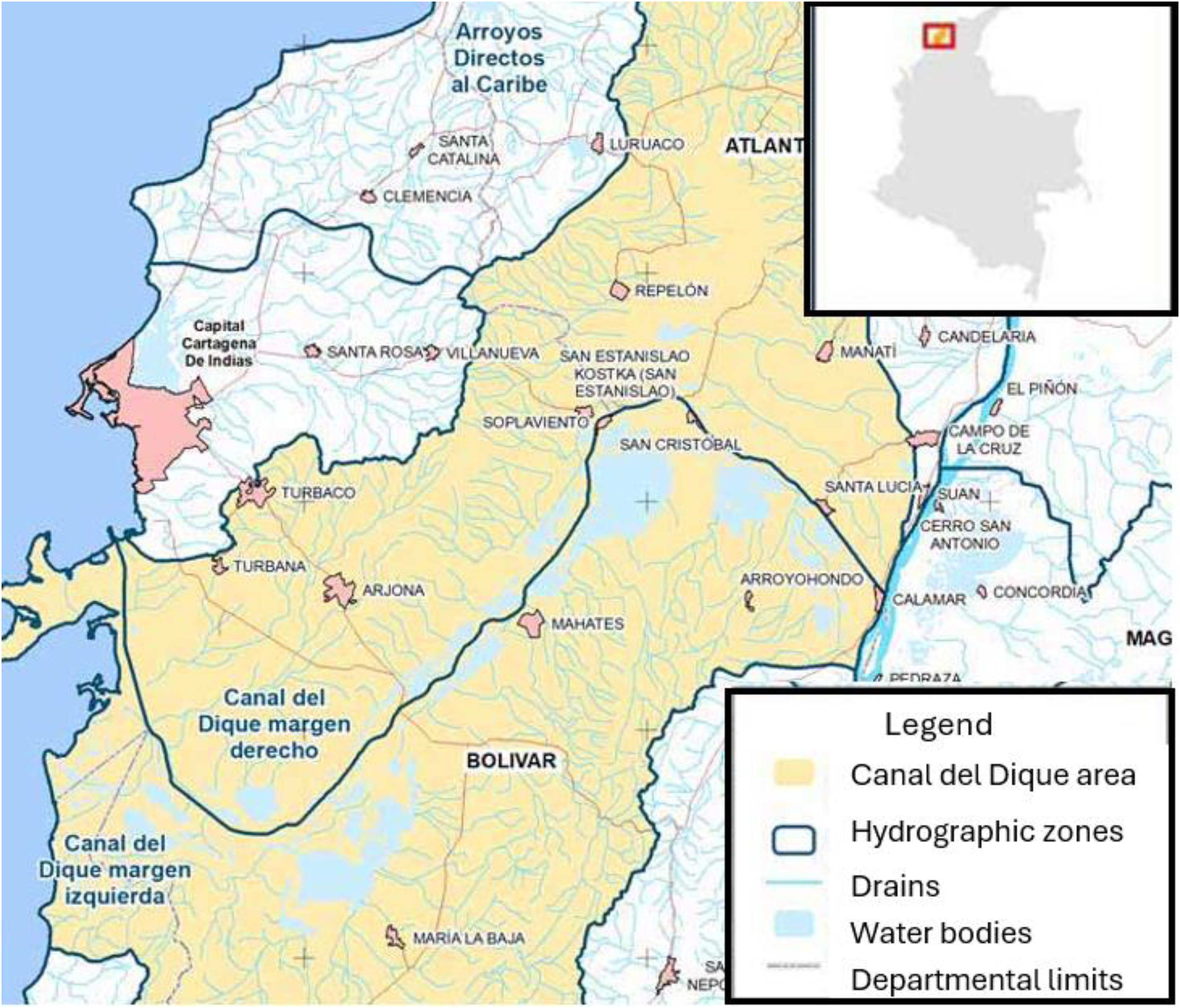
Study area of Canal del Dique in northern Colombia (adapted from Ministerio del Ambiente, 2026).
The lands surrounding the canal are characterised by flat and visually monotonous alluvial plains, fragmented by large complexes of swamps, streams (caños 1 ), wetlands, and lagoons, collectively known as ciénagas. Before and at the time of the Spanish arrival in the early sixteenth century the floodplain area was inhabited by various communities that lived from fishing, hunting and farming the ciénegas that depended on and were shaped by the flood-pulse of the Magdalena River (Cuervo and Peña, 2014; Díaz, 2006). The ciénegas create a network of shallow aquatic bodies, some isolated, some interconnected with each other, through the caños, some linked with the canal, and others connected directly to the Magdalena. Due to these connections, the ciénegas buffer the flow of the canal and the river. Twice a year, during periods of intense rainfall, water levels in the canal and the ciénegas rise, inundating large parts of the plains. These dynamics stimulate a high biological diversity of terrestrial and fish species; and very productive sedimentary soils.
The ciénegas are physical remnants of past floodings and represent the spaces where one can find people engaged in the primary cultural and economic activities of the region, namely fishing and agriculture (Díaz, 2006). Within the expanse of the ciénegas and the canal, fishers embark daily in the pursuit of capturing fish, whilst farmers spend their time labouring on the nutrient-rich banks. In the area of Canal del Dique, the role of fishers and farmer is often embodied by the same person. During the rainy season, when large areas are flooded, they engage in fishing activities, and during the dry season (when floodplains become accessible) in farming. Accordingly, people are dependent on this seasonal variability for their primary cultural and economic activities.
However, what is found today in terms of an amphibious culture appears to be a stubborn and spatially confined remnant of what used to be a much wider expanse of a flood-pulse dependent floodplain area of the Magdalena River that was dominated by dynamic ciénegas, playones and an abundance of migratory fish species. The flood-pulse regime of the ciénegas in the area has been greatly curtailed and controlled. Many of the original ciénegas have ceased to exist, but there are still communities that sustain their amphibious lives. They live in and around ciénegas in which both the fishing as well as the agricultural regimes are subject to the rhythm of floods and droughts. As a fisher explained in Higueretal: “Right now we have pancoger 2 on what one calls ‘firm ground’, the land that is high up. But in summer we usually go to the playones [fertile grounds that appear as the flood recedes].” (July 27, 2022). Livelihood activities are thus synchronized with environmental cues of the river: “…A lot of farmers and fishers, they are both. They fish in the time when there's fish, and they have the agricultural plots, so they need those two things” (June 16, 2022).
The importance of playones for agricultural production in the water pulse cycle is highlighted in Higueretal: “All the lands that are on the margin between the Canal del Dique and the bodies of water of the swamp are cultivated (…). In time they are flooded for two months, and then they are flooded again. And that makes them keep their humidity during the whole year, no matter how long the drought is. The soils are very rich in minerals and very productive…” (July 27, 2022). An extension worker corroborated: “the playones offer security because they are lower and wetter soils.” (August 19, 2022). He continued by explaining that the people in this area are used to these dynamics: “They are conditioned to the circumstances they are living in. Right now, the river exceeded the historical permissible limits, and so some of the pastures have been lost. But when the river goes down, then there are soils that are left with certain nutritious substrates (…) There is always corn afterwards and it gives fabulous harvests” (ibid.). As such amphibian culture has persisted as was proudly expressed by the cultural manager in Mahates: “we coastal people are amphibious beings. We feed from the land, and we feed from the water.” (July 27, 2022). However, due to the alterations that have been made to the flood-pulse regime in the whole area and new infrastructural proposals, the people that still lead amphibious lives are threatened by enclosures.
Enclosing and transforming eco-societies through hydraulic infrastructures
Making Canal del Dique a navigable river
The environment in the area of Canal del Dique has long been subject to anthropogenic intervention. To enable vessels to travel from Calamar to Cartagena in the bay of Barbacoas throughout the year (river-as-subject for transport and navigation), in the ‘dry’ season of 1650 - between march and august - the first infrastructural adaptation was made to this area by creating permanent connections between the ciénegas and the river (Bermán y Camargo, 2024). The construction of this new infrastructure was commissioned by the governor of Cartagena to enable the port of Cartagena to take a much more strategic position in the commerce route between the sea and the upper Magdalena river. The canal would allow vessels to directly reach the upper Magdalena without having to transport the goods over land which was done by mule (see Figure 3) (Díaz, 2006; Mogollón, 2013). The latter was achieved by constructing two canals one in the east in the region of Matumilla and the other one in the west to permanently connect the lagoons with the Magdalena River (Lucena-Giraldo, 2013).
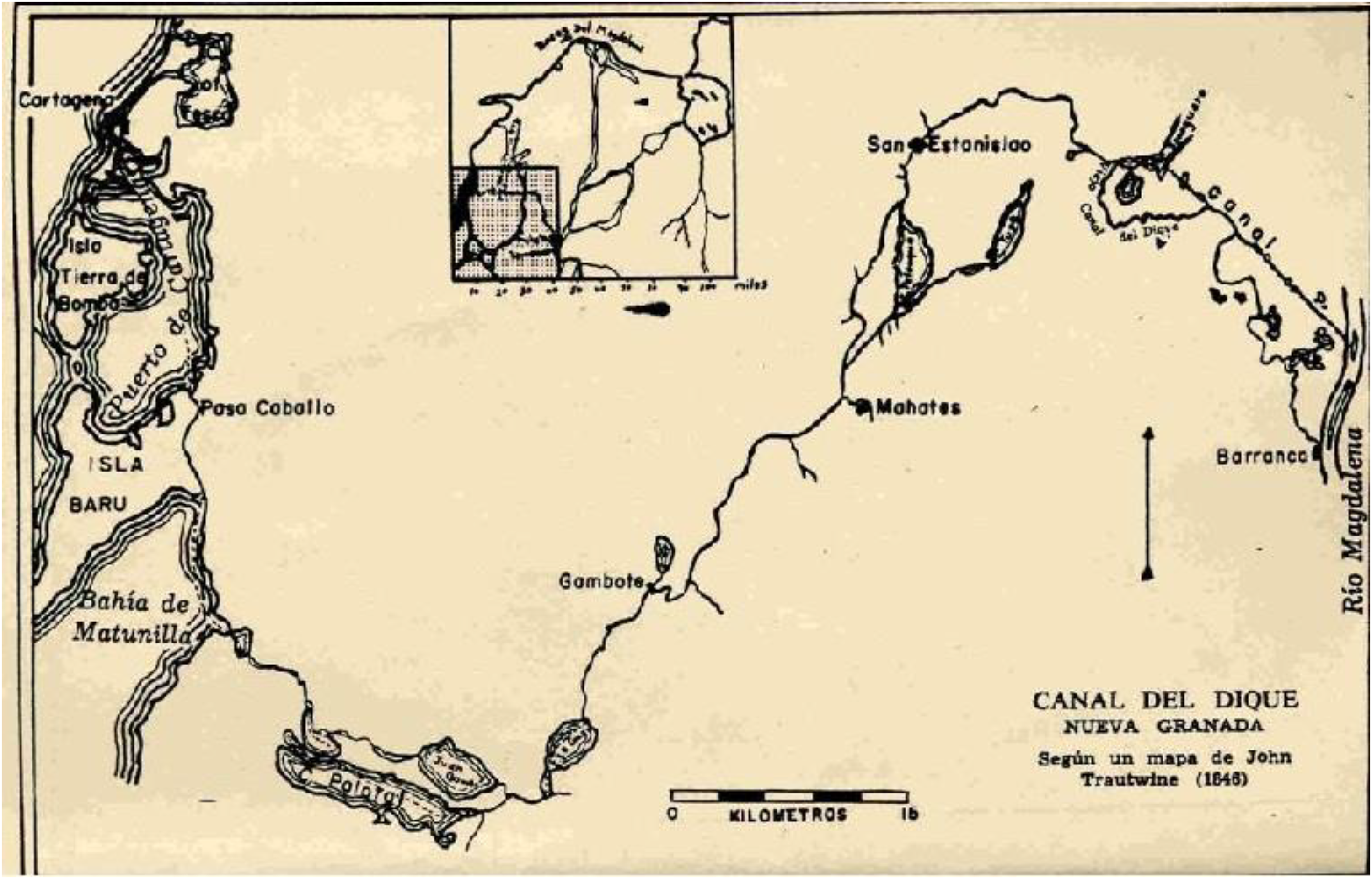
Canal del Dique around 1846 (source Mogollón, 2013).
According to Lucena-Giraldo (2013), these new connections enabled ships and vessels to pass the new route from Cartagena to the Magdalena river in 3–4 days. However, according to the same author, by 1679 only the stretch of the canal between Matumilla and Mahates was still navigational, due to a lack of maintenance and sabotage by mule ferriers. In the decades that followed the canal went through different maintenance, transformation and modernization rounds including a new entry to the Magdalena river, the construction of sluices, reinforcement of dikes and more. As this inland transportation route became more important, the canal that connected the different swamps was gradually deepened and widened, becoming a permanent drain for the Magdalena River. Gradually Canal del Dique became a boxed channel of roughly 115 kilometres that is surrounded and fed by a vast expanse of networked swamps (ciénegas), that expand and contract with the flood-pulse of the Magdalena River (Mogollón, 2013).
The river around Canal del Dique drastically changed after the 1950s when, through hydraulic infrastructures, both the canal and the adjacent floodplains were radically altered. This was done based on imaginaries of modernizing the river for navigation and for modern agriculture in permanently dry floodplains, which would be achieved through the ‘control and/or the correction of nature’ with hydraulic infrastructures (river-as-modernized subject). Between 1951 and 1952, rectifications and the removal of bends in the canal to facilitate navigability and to allow for the passage of larger ships transformed the physical layout of the canal and the water flows through it.
In 1973 Nedeco 3 , in an administrative agreement between the Colombian and Dutch government, completed a survey project for the Río Magdalena and Canal del Dique. Several ‘defects’ from the perspective of navigability of the river were concluded including: (i) insufficient depths and channel widths during a part of the year; (ii) too sharp bends; (iii) a high sinuosity; (iv) an unstable navigable channel; (v) rapids and locally-encountered high velocities; and (vi) the presence of floating debris (Nedeco, 1973). Between 1981 and 1984, the Ministry of Works again ordered infrastructural interventions to widen, rectify, and deepen the canal further. These ‘improvement’ works responded to the ambition of the transportation company Naveira Fluvial Colombiana 4 to increase the size of its convoys through Canal del Dique (Universidad Libre, 2017). The improvements for navigation brought about several adverse effects (Universidad Libre, 2017). The elimination of bends meant that the water was able to acquire a greater velocity and consequently carry more sediment (ANI, July 15, 2022). A representative of the local fishers organisation in the area commented on these works: “The Colombian engineers… they took out 38 curves, and it was replaced with a straight canal, and now all the sediment comes straight into the bay of Cartagena.” (July 26, 2022).
Alongside the aforementioned changes to the navigation canal, the landscape, land use, and wetlands adjoining the canal also underwent severe and progressive changes in this period. These changes were spurred by the idea that this area had to be developed and modernized so that it could better integrate and contribute to the Colombian economy by boosting agricultural production. This was to be achieved by taming the flood-pulse regime through hydraulic infrastructures.
Taming the flood-pulse: enclosing amphibious livelihoods for modern agricultural development
Drying up lagoons and enclosing land: advancing the techno-modern imaginary 5
Since the 1960s, hydraulic infrastructures were built to drain wetlands and make them permanently ‘dry’. The construction of these infrastructures was financed and advanced by both governmental programs as well as by large landowners who wished to transform the river into ‘dry’ land for year round, often large scale modern agricultural or livestock activities (Camargo, 2012). The Colombian government aimed to turn the southern department of Atlántico into a modern regional agricultural hotspot making use of its fertile soils and good weather conditions. The district became a target area for agrarian development, and the swamps were drained by Incora 6 in the 1960s (Bacerra, 2015). Alejandro Camargo, in an article written for the newspaper El Espectador, expands on this: “The initial problem was the amount of water in the region. […] No large-scale agricultural enterprise would thrive in such a changeable environment.” To protect agricultural lands from flooding a 70-kilometre embankment was constructed to protect the south of Atlántico. As a result, the ciénegas began to dry up and “… the longed-for agricultural land seemed to emerge” (Camargo, 2015). At this time, the modernist idea of swamps (ciénegas) as unproductive wastelands and obstacles to development was well rooted. Ciénegas were intentionally portrayed as places devoid of all human activity and with great potential of becoming productive agro-economic landscapes (Camargo, 2012).
A representative of the farmers organisation in Soplaviento noted: “70 to 80% of the bodies of water that had stretched behind the Canal del Dique is gone, they were lost” (July 27, 2022). Victor, a professor of transport at the Universidad del Norte, summed it as follows: “…most interventions were during the last 50/60 years. […] all this used to be a ciénega. But the ciénega dried and the land use changed. They [my parents] were fishers, but they changed to become farmers” (July 5, 2022). By draining wetlands, land and landownership were ‘fixed’ allowing for the modernization of the area through agricultural production of cash crops. For advancing these modernization ideals, amphibious communities were given land, credit and agricultural extension support services that would make them modern. In this way hydraulic infrastructures dried the floodplains and forced its inhabitants to become modern farmers in a new riverine ecosociety.
Originally, the playones were accessible for only a few months each year, and customary and collective usage of the land turned it into a communal space that did not require formal property titles. Landowners, peasants, and fishers used the land annually and sometimes jointly, but the land was also demarcated for individual or family use until water levels rose (Camacho, 2015). However, those with the power to control the land, either through enclosures, force, or manipulation of the law, eventually turned these lands into a privilege for themselves, or for the subjects they aimed to create, in this case farmers (ibid.).
Talking of this enclosure, a peasant in Soplaviento noted: “It has an impact on our food security. Right now, there is a fight between the fishers and the landowners. (…) There are landowners that have plenty of land, and they make the fences go up and do not let us plant crops…” (July 27, 2022). The president of the fishers association: “The landowners have taken over everything, they have their thousands of hectares” (July 30, 2022). Conclusively a fisher in Soplaviento spoke: “There is a class struggle. Because the landowners, they have better economic conditions, and when the ciénega dried up they took over the land, and we fishers were left with our hands empty.” (July 27, 2022).
Landowners go out of their way to claim newly emerging lands but also attempt to actively drain ciénegas. The mechanisms used to achieve this appropriation include infrastructures such as temporary embankments, fences, the active draining of the wetlands through makeshift canals, and securing access to land through violence and private militias (Guerra, 2018). Through these river transformations great tracts of the ciénegas have been permanently drained (see Figure 4).
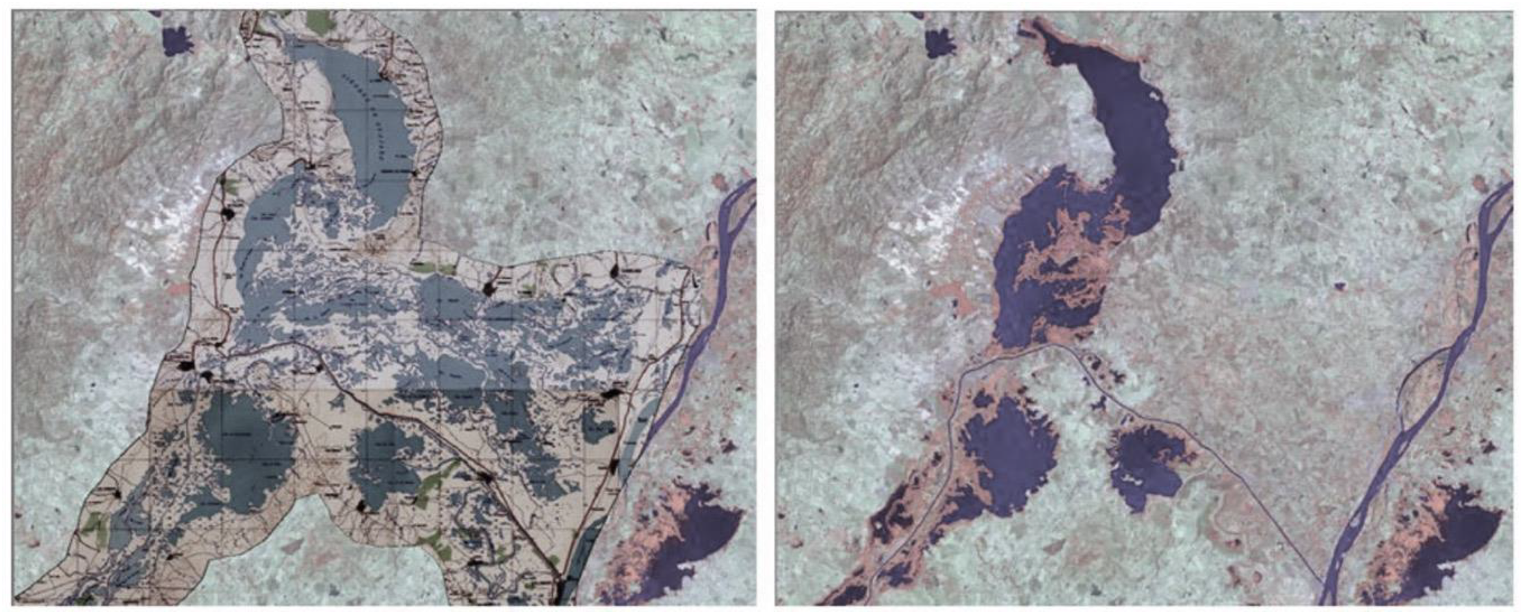
Images showing the situation of the ciénagas in the flood zone of Canal del Dique between 1953 (left) and 2014 (right) (Cuervo and Peña, 2014).
Enclosed fishes and fishers
The drive to ‘fix’ land and tame the waters has greatly affected fisheries. Ciénegas have been dried and the infrastructures that have been built to tame the flood-pulse have resulted in the reduction and/or loss of hydrological connectivity between and among the different ciénegas and the Magdalena River. This has reduced the flood-pulse dynamics but also and importantly the migration of fish species on which amphibian livelihoods depend. In the Magdalena river, for instance, the migration cycle of potamodromous fish 7 is dependent on this hydraulic connectivity and related flood-pulse (Jiménez-Segura et al., 2022). Low river discharge and decreasing water levels, combined with a temperature rise and falling oxygen levels, signal fish to migrate upstream where spawning occurs. Downstream migration in turn occurs again at higher discharges, and during the period of elevated water levels when fish stay in the ciénegas where plenty of food is to be found (Camargo, 2021; Jiménez-Segura et al., 2022).
Another example of a species that depends on the flood-pulse is the Bocachico fish that travel up to 1000 meters in elevation and represent the highest percentage of total fish caught by artisanal fishers along the Magdalena River (Jiménez-Segura et al., 2022). This fish had become rarer: “The Bocachico spawns in the river (…) they reproduce in the canal and from there they try to enter the ciénegas. But they [the government] have blocked all the connections…” (Fishers Higueretal, July 27, 2022). For fishers along the Guájaro, it seemed even more dire: “It is rare for a fisher to catch three Bocachico in the whole year” (August 1, 2022). Many fishers attribute this sharp decline to the loss of connectivity between the ciénegas and the Magdalena River. Some fishers have taken it upon themselves to open connections between the canal and the ciénegas: “I cleaned up everything to let fish in (…) They don’t pay me anything, I do it because I live here”. Another fisher corroborated this: “This caño, which is natural, it is existing thanks to him (…) the entity that supposedly wants to preserve the environment closed this natural canal with a floodgate…” (August 1, 2022). Attempts to address the declining levels of fish have also been made by the National Aquaculture and Fisheries Authority and regional and local governments. Various restocking programs, whereby fry 8 is released in the ciénegas have been executed in an effort to guarantee livelihood opportunities for fishers (El Tiempo, 2021; Gobernación del Atlántico, 2022; Tirado, 2017).
An alternative that has been promoted amongst fishers is pisciculture. Through the creation of new hydraulic infrastructures in the form of ponds on ‘dry’ land, fishers are lured to switch from fishing in the ciénegas and the canal to start fish farms. In places like Manatí, Soplaviento, and Villa Rosa fishers associations ventured into pisciculture as an alternative to wild capture: “artisanal fishers don’t have anything else. I mean, we have to look for another alternative” (Fisher Manatí, July 31, 2022). Many pisciculture ventures are collectives. A fisher in Repelón explained: “So we’re artisanal fishers, but we chose to come here [in the fish farms] because we’re doing pretty bad over there” (August 1, 2022). For many, pisciculture has become a necessity to sustain livelihoods; while others keep on trying to make a living from fishing in the open waters.
New plans for ‘taming’ the flood-pulse and protecting the capitalist river eco-society: the eco-modern imaginary 9
In late 2010 and early 2011, the water of the canal broke through the embankments and flooded hundreds of homes in several municipalities. As the floodwaters receded the president of Colombia deemed the catastrophe a consequence of climate change and therefore formulated plans for climate change adaptation to reconstruct the economy and infrastructure of the area (Camargo, 2022a, 2022b). This new focus resulted in the creation of Fondo Adaptación, an entity attached to the Ministry of Finance and Public Credit tasked with the construction, reconstruction, recovery, and economic and social reactivation of the areas affected by the La Niña phenomenon. With this new entity also came additional money, and in early August of 2013, Fondo Adaptación in conjunction with Cormagdalena, the environmental authority in the department of Magdalena, contracted studies with the consultancy firms Gómez-Cajiao and Royal Haskoning-DHV to make plans to restore the degraded ecosystems of Canal del Dique whilst protecting the area from flooding (Bacerra, 2015).
These studies led to a new river-as-subject project which, in the words of an executive at Cormagdalena: “It's a complete vision of the river, on its navigation extent and its environmental extent as well. It is an infrastructure project that is highly defined as an environmental project” (May 12, 2022). An employee at Cormagdalena listed the following project objectives: (i) restore the ecosystems, including the corals, wetlands, and productive areas; (ii) control the inflow of sediments; (iii) guarantee permanent navigability; (iv) control the floods; and (v) provide water to the communities (June 6, 2022). This ‘new restorative’ infrastructure project includes two control structures and sluices, located upstream at Calamar, and downstream at Puerto Badel (Sokolewicz et al., 2016). The main purpose of these gates is to regulate and reduce the volume of water and sediment entering Canal del Dique. The plan entails that the base flow will be enough to guarantee the water depth needed for navigation in the Canal (ibid.). The structure at Puerto Badel controls water and sediment flows into the bay of Cartagena by redirecting the flow westwards through a drain (see figure 5).
Impression of the projected Canal del Dique (source: ANI, 2025).
The project also aims to increase the water availability for irrigation and other purposes in the area throughout the year. To do so, in the project design, the water level of the ciénegas will be raised throughout the year. However, as the design includes lower levels in the canal, the ciénegas will have to be disconnected from the canal. The largely isolated ciénegas are intended to be interconnected with each other but not with the canal. Furthermore, the ciénegas are expected to experience diminished and fully controlled flood-pulses. As the ciénegas will be isolated from the canal, the project design has included fish passages between the ciénegas, the canal and the river. The assisting ecologist highlighted: “We have ensured that the hydrological system is suitable for those [migratory] species by means of fish passages… [but]…We do not know whether that will succeed…” (June 16, 2022).
Fishers question the possible negative effects of full environmental control through hydraulic infrastructure: “Are the things really as they say, where is really the truth of this project? This project for me is destructive for the communities. They have made some models for the current and the rise of the tides found in nature. They are modelling in their own way, but we as fishers have told them differently (…) if it floods, nobody can stop it, nobody. Because none of us can control nature. So, they have a model of the current, of the tide. But for us, that doesn’t convince us.” (Fisher Pasacaballos, July 26, 2022). Despite claims of improved fish quantities facilitated by restocking programs and fish ladders, fishers express serious doubts about the effectiveness of these infrastructures: “Well the state is thinking of building a lock here in the canal, which is directly detrimental to the fish. I mean, the children's daily food is going to run out because the fish is not going to be able to get in the ciénegas and is not going to be able to get out.” (Fisher Santa Lucia & Repelón, July 30, 2022). Fishers in Higueretal spoke: “We assume, according to our knowledge, that the fish is going to decrease by 90 or 95% (…) We are no longer going to have endemic species [that depend on migration].” (July 27, 2022). Others were more distrusting: “The Canal del Dique project is not focused on improving the lives of the communities. It is made for the capitalists and to finish with the riverside populations of Canal del Dique (…) The water is going to die a private death. The water is really going to die.” (Fisher Higueretal, July 27, 2022).
In recent years, amphibious communities have joined together claiming that taming the Magdalena River has led to the violation of their human and cultural rights. This has been done, amongst others, through the Cimarronaje Route. This is a collective process that encompasses approximately 200 social organisations from the Colombian Caribbean that aim to defend the rights of ethnic communities in the Canal del Dique region. The political agency of this social movement gained strength following the inauguration of President Gustavo Petro (2022–2026). The majority of fishers and farmers who participated in this research demonstrated a high level of engagement in supporting Gustavo Petro and expressed optimism about the anticipated changes, as outlined by the President-elect. He promised that the project would not move forward without an environmental license (Arrieta, 2022). Today, the Ministry of the Environment has not given green light for the project, as the environmental studies are under review. However, the mayor of the city of Cartagena, together with the governor of the Department of the Atlantic, is defending the project as an important initiative for the recovery of degraded ecosystems and the protection of communities at risk of flooding (Herrera, 03 October, 2024, El Tiempo). Besides, the private public alliance between Sacyr Concesiones and ANI signed in may 2025 a document that officially certified the start of the restoration of the degraded Canal del Dique ecosystems project 10 .
Transformed and hybridized river eco-societies
Many communities and fishers collectives that still live amphibious lives resist the new restorative infrastructure project. However there are also numerous communities and private interests for which flood-pulses have become a threat rather than the source of sustenance for their livelihoods and related forms of living. The threat of flooding has become a concern for many communities. In Santa Lucia people are constantly worried: “When they feel that the water is rising, they are going to spend all night patrolling on the motorbike (…) I don’t think people are very calm, we experience an uneasiness right now” (July 26, 2022). However, the sense of fear of flooding is not unfounded. In Villa Rosa, a community member exclaimed: “The water levels in Canal del Dique go up and up and then it spills, it is bad when it spills, and the water comes to here [the place we were standing] and then we suffer. We have been flooded twice this year.” (July 31, 2022). An extension worker discussed this distress: “So, every year it seems like the same floods. And then the people run, generally the marginalised, generally the people who do not have, not even enough food to eat twice a day. They are the ones who suffer the floods” (August 19, 2022).
The current project plans promise an amenable future with fixed land and controlled ciénegas. Project developers highlight that with the construction of two large sluice gates, the inflow of water will be actively regulated; as an ecologist of RHDHV stressed: “…our system makes the hydrology much more predictable, much quieter. You prevent large-scale flooding…” (June 16, 2022). A representative of ANI corroborated this: “… yes, we are going to prevent overflow processes (…) We are never going to allow flooding processes, except, let's say we have a hypothesis of once every 100 years” (July 15, 2022). A local NGO representative explained that the government had to emphasize the flood control dimension of the project for people to accept it: “This process was very important. Because at the beginning they [the people of the area] didn’t want it [the project]. But when they realized what the project was and what it meant for the territory to be with or without the project [i.e., fewer floodings], they started to value more what the government was doing with the project” (July 7, 2022).
This reality has transformed the visions, cultural values, livelihood strategies and imaginaries of local communities that have transitioned from an amphibious culture to a terrestrial culture. The latter requires fixed dry land and controlled waters with predictable and tamed flood-pulses. As a result, for this new river eco-society, flood safety has become the primary concern. As more and more lives and related culture have become terrestrial, fixed and threatened by flood-pulses rather than enlivened and sustained by them, the political power and related agency of the few that still live amphibious lives has shrunk.
Conclusions: the Riverhood spiral
In this article we analysed the socio-material transformation of Canal del Dique and its ciénegas through a slightly adapted version of the four dimensions of the Riverhood framework (Boelens et al., 2023). Through our adapted theorization, we used the four interlinked Riverhood dimensions to analyze the broader hydrosocial dialectics through which the river, as an integrated socio-material-ecological entity, has been transformed since colonial times. In doing so, we turned our attention slightly away from a centered focus on the role of riverine movements in (re)shaping rivers, to a broader view that focused on the role of powerful public-private alliances, their river subjectivations, related territorialization projects and the riverine grassroots organization's responses to these projects. We show that hydraulic infrastructures are a fundamental cornerstone of river territorialization as they transform the flows of water and with it also riverine ecologies and related societies. The close interrelatedness of these four dimensions of riverine transformations is illustrated though the alliteration to the Möbius band. This alliteration points us to the fact that these four dimensions play out in the same geographical plane (space), that they are multi-dimensional -that is simultaneously social, material and symbolic-, and that they are dialectically intertwined. A fourth dimension is that of time, pointing at the recognition that in Riverhood dialectics there is never a (re)turn to a same point, a fixed eco-society, subjectivation, territorial strategy or riverine movement. These different dimensions express dynamically and could therefore be better grasped by an alliteration to a theoretical Möbius spiral that continually and dynamically evolves over time but never returns to the same point.
Upon the above, our analysis of Canal del Dique shows how since the Spanish colonization, powerful actors have subjectified the river to advance their interests. In first instance, these efforts were rooted in the interest of establishing a navigable transport route from Cartagena to the Magdalena River (river as navigation route). Since the 1950s, techno-modern imaginaries have subjectified the river not only as a navigation route, but also as a space for advancing economic development through modern agriculture in the fertile floodplains. Through territorialization projects premised on the construction of hydraulic infrastructures, the river that the state and governing elites aimed to create has been advanced. This modern river is premised on taming the flood-pulse to create fixed dry land to enable the development of modern terrestrial livelihoods and cultures. As a result over the last decennia the riverine eco-society has been transformed by dikes, sluices and other smaller infrastructures from an amphibious eco-society based on the ‘natural’ flood-pulses of the river to a predominantly terrestrial eco-society based on a controlled river that enables modern agriculture on privatized ‘dry’ land.
The new riverine eco-societies have become a hybrid of remnants of amphibious cultures, fishers and peasants; most of which have come to see the flood-pulses of the Magdalena River as a threat rather than as a natural rhythm that enables living on both land and water. Within this context the government has developed new plans for further modernization based on imaginaries of environmental restoration and flood risk reduction in the floodplains. This is to be achieved by controlling water and sediment in and out flows to the ciénegas by fixing their borders and turning them into fully controlled and managed ciénegas.
As such this project follows the same modernizing trend that has transformed the riverine eco-society around Canal del Dique over the past century. An eco-society that has become less amphibious and more reliant on technology that fixes water and terrestrial borders. These dialectics show how in Canal del Dique, modernist notions encoded in hydraulic infrastructures have facilitated the enclosure of not only common resources, wetland systems and fish migration routes, but also amphibious cultures that rely on the flood-pulse of the river. The enclosure of amphibious cultures has made space for privatized ‘dry’ land and an agriculturally dependent terrestrial culture. Under the guise of modernity, safety and economic prosperity the projects are rationalised, and other cultural visions of the river are curtailed, fenced-off and enclosed. The social organisations from the Colombian Caribbean that have organized and mobilized to reconnect the broken socio-natural ties advance and defend the cultural values of amphibious livelihoods. Through it, these movements contribute to new ways of thinking, living and subjectifying rivers, not back to what they once where, but rather to what rivers are today and intervening in the river making future through the defence of their amphibious cultural identity. In doing so, they hold the seeds for advancing a riverine Möbius spiral that is more socially just and environmentally sustainable in a complex, heterogenous and conflictive river.
Highlights
Hydrosocial river modernization is analyzed through an adapted notion of ‘riverhood’
Territorialization of the riverine landscape is predominantly advanced through hydraulic infrastructures
The control of the flood-pulse of the Magdalena River through hydraulic infrastructures has enclosed amphibious cultures
New terrestrial cultures that are threatened by the flood-pulse of the river have been created.
Social movements are struggling to sustain their amphibious cultures.
Footnotes
Acknowledgements
We would like to thank the three anonymous reviewers and the editor for their excellent comments and suggestions and Harry Quealy for language editing. This research as funded by: the European Biodiversity Partnership Biodiversa+, under the 2023–2024 BiodivNBS joint call. It is co-funded by the European Commission (GA No. 101052342) and the following funding organisations: Ministerio de Ciencia, Innovación y Universidades/Agencia Española de Investigación, Ministero dell’Università e della Ricerca, Netherlands Organisation for Scientific Research (NWO), and Agence Nationale de la Recherche; and the European Research Council under the Horizon 2020 program [Riverhood, grant no. 101002921]; and by the INREF-WUR funded transdisciplinary research and education program [River Commons, INREF2020] (see ![]() ).
).
Funding
The authors disclosed receipt of the following financial support for the research, authorship, and/or publication of this article: This research was funded by the European Research Council (ERC) under the EU's Horizon 2020 Program (Riverhood, grant agreement No. 101002921) and the Riverscape Conviviality (RiVIVE) project funded by the European Biodiversity Partnership Biodiversa+, under the 2023-2024 BiodivNBS joint call. It is co-funded by the European Commission (GA No. 101052342) and the following funding organizations: Ministerio de Ciencia, Innovación y Universidades/Agencia Española de Investigación, Ministero dell'Università e della Ricerca, Netherlands Organisation for Scientific Research (NWO), and Agence Nationale de la Recherche.
Declaration of conflicting interests
The authors declared no potential conflicts of interest with respect to the research, authorship, and/or publication of this article.