
Abstract
As more nations build and launch their own spy satellites, secrecy is becoming a thing of the past.

In the summer of 1977, a Soviet reconnaissance satellite returned images of suspicious activity at the Vastrap testing range in South Africa's Kalahari Desert. After receiving a message of concern from Soviet General Secretary Leonid Brezhnev, the United States used one of its own satellites to photograph the area. The images obtained by both superpowers led them to conclude that South Africa might be preparing to conduct a nuclear test. A diplomatic campaign by the superpowers and several European nations prompted South Africa to proclaim that it had no plans to detonate an atomic device.
At the time, only the United States and Soviet Union possessed the space reconnaissance capabilities to detect, from Earth's orbit, suspicious activities deep in the interior of any nation. While China launched its first spy satellite in 1975, Chinese satellite reconnaissance missions were brief and, for many years, typically involved a single, short-lived mission each year, in contrast to the yearlong coverage achieved by U.S. and Russian satellites.
Today, less than three decades after the summer of 1977, the space reconnaissance club has expanded. French, Israeli, and Japanese spy satellites now circle the planet on a daily basis. And they are not the only other nations that have, or will have, an ability to spy from space in the coming decade.
Satellite proliferation has accelerated with the proliferation of missile technology, as more nations have developed rockets capable of sending pay-loads into Earth's orbit. Furthermore, the diffusion of advanced remote sensing technology has allowed governments to acquire high-resolution images that were once the sole purview of the United States and the Soviet Union. “Over-the-horizon information is a new source of geopolitical power, like nuclear weapons,” an aide to French President Jacques Chirac once observed. 1 Also underlying the quest to develop eyes in the sky has been the mounting frustration among U.S. allies who resent Washington's occasional reluctance to share satellite imagery. “For years we have been begging the Americans for more detailed pictures from their satellites and often got refusals–even when Iraqi Scud missiles were falling on Tel Aviv,” an Israeli defense official complained in 1992. 2 Likewise, a chilling moment in U.S.-European relations came in 1994, when, in response to a congressional order to cease American support for the U.N. arms embargo against Bosnia, the Clinton administration promptly cut off satellite intelligence on ship movements in the Adriatic Sea to its NATO allies.
SEEKING RESOLUTION
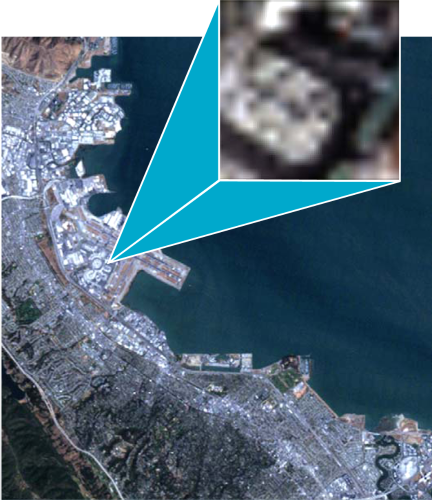
In satellite lingo, “resolution” is defined as the minimum distance between two objects that can be measured or distinguished by a data-capturing or imaging device. Put another way, a surveillance satellite capable of producing 1-meter resolution images can distinguish objects on the ground that are 1-meter in size or larger-provided those objects are well removed from other objects.
While 25-meter resolution imagery is adequate for mapping, environmental assessments, and forestry management, 10-meter resolution is the outer limit of what is required for gathering meaningful military intelligence. Indeed, for eyes in the sky, gradations of just a few meters can make a world of difference.
SOURCES: COMPANION WEB SITE FOR CONCEPTS AND TECHNIQUES OF GEOGRAPHIC (WWW.PRENHALLGEO.COM/LO); NATO OPEN SOURCE INTELLIGENCE HANDBOOK (NOVEMBER 2001); YIFTAH SHAPIR, SATELLITE TECHNOLOGY IN THE MIDDLE EAST, JAFFEE CENTER FOR STRATEGIC STUDIES, MAY 2004; FEDERATION OF AMERICAN SCIENTISTS, “IMINT 101,” (FAS.ORG/IRP/IMINT/IMINT_101.HTM). IMAGES COURTESY OF SPACEIMAGING.COM.
For some, the prospect of a world where everyone is capable of watching one another raises worrisome issues. Surveillance could facilitate the precise targeting of both conventional and nuclear weapons. High-resolution satellite imagery could fall into the hands of terrorist groups, or foster regional conflicts by giving rival governments access to vital intelligence in military planning. Yet, for others, this emerging era of global transparency holds the promise of enhanced international stability. “Nations that know what their enemies are doing are less likely to increase world tensions through actions born of fear,” national security journalist R. Jeffrey Smith has observed. “And nations that know their enemies are observing them are far less likely to threaten international peace through rash behavior. Governments are also more likely to propose and sign treaties if they believe they can verify their enemies' compliance with treaty terms.” 3
FRANCE MARKS THE SPOT
In late January 1965, Edgar L. Piret, the scientific attaché of the U.S. Embassy in Paris, transmitted a confidential cable to the State Department. In it, Piret reported on his meeting with Christian Fayard, of France's National Center for the Study of Telecommunications, who told him that his team of hardware specialists would be working on three different military space projects. One project involved developing a “television camera which will photograph various parts of the Earth” and transmit the images to a ground station. 4
But no French reconnaissance satellite emerged in the 1960s or 1970s. It was not until February 1986 that France launched the first SPOT (System Probatoire d'Observation de la Terre) satellite–a commercial imagery spacecraft that produced black and white images with a resolution of 10 meters (33 feet) and color images with 20-meter resolution. In contrast, U.S. Keyhole reconnaissance satellites commonly produced images with a resolution of 15 centimeters (6 inches).


France had planned to deploy a modified version of SPOT, designated SAMRO (Satellite Militarire de Reconnaissance Optique), that would have produced much higher resolution images. Development work was to begin in 1982-1983 and result in a first launch in 1986 or 1987. Then, in 1982, the SAMRO program was cut back and limited to work on a camera system. 5 Almost a decade later, one individual's actions guaranteed that France's development of its own spy satellite would become a top priority. That individual was not a French scientist or politician, but a Mideast dictator named Saddam Hussein.
In a May 1991 address in Paris, French Defense Minister Louis Joxe repeatedly emphasized that allied victory in the Persian Gulf War was largely due to the intelligence provided by U.S. reconnaissance satellites. He told his audience that “our extreme dependence on American sources of information … was flagrant.” He went on to argue that “no nation could have serious worldwide ambitions without operating its own constellation of reconnaissance satellites.” 6 President Chirac was even blunter, later complaining that without indigenous satellite capabilities, Europe would be little more than a “vassal” of the United States. 7
Determined to stake its claim to the high ground of Earth's orbit, the French government's Helios satellite reconnaissance program–which had replaced the SAMRO program in 1986–would not suffer the fate of earlier programs and whither away from bureaucratic apathy and inadequate funding. Four years later, with financial help from Italy and Spain (who together paid 21 percent of the cost), an Ariane booster lifted off from the launch site at Kourou in French Guiana on July 7, 1995, and placed Helios 1A in a 675-kilometer (420-mile) polar orbit. While the reported resolution of Helios 1A photographs was, at 1 meter (3.25 feet), significantly inferior to that of images produced by U.S. and Russian satellites, it was a considerable improvement over what could be obtained via SPOT 8
Over the next decade, France kept its membership in the satellite club active by launching new Helios satellites as predecessors came to the end of their lifetimes. On December 3, 1999, an Ariane booster carried Helios IB into orbit. A little over five year later, on December 18, 2004, Helios 2A launched from Kourou and was placed in a polar orbit 643 kilometers (400 miles) above the Earth. The new satellite, partially funded by Spain and Belgium, was a significantly improved version of the earlier generation in several ways. Its imaging quality was estimated by one source to be less than half a meter (1.6 feet). In addition, it has an infrared sensor, allowing it to obtain imagery during darkness. And, rather than delivering dozens of images a day, as Helios 1A had, it delivers about a hundred. 9
ISRAEL'S NEW HORIZON
While France was the first nation to join the space reconnaissance club after the Cold War, it was not the only one. Like France, Israel had often relied on the United States to provide imagery that Israel could not obtain–at least not without conducting aerial reconnaissance missions that risked political and military disaster. But the relationship, according to one head of Israeli Military Intelligence, was that between “a patron and his dependent.” Meir Amit, who also headed military intelligence before becoming the chief of the Mossad, told Israel Radio in 1988 that “if you are fed from the crumbs of others according to their whim, this is very inconvenient and very difficult.” 10
Among the instances Amit undoubtedly had in mind was the U.S. inability, or unwillingness, to provide satellite imagery to Israel in the days before the 1973 Yom Kippur War. In addition, while Director of Central Intelligence (DCI) George H. W Bush had approved providing imagery to Israel, his successor, Stansfield Turner, restricted Israeli access to imagery-derived information. The rollercoaster ride continued during William Casey's tenure as DCI from 1981 to 1987, with Israel initially receiving images that collectively covered a wide portion of the Middle East. But after the Israeli Air Force attacked Iraq's Osirak nuclear reactor in June 1981 (while Casey was out of town), Deputy DCI Bobby Inman restricted Israeli access to photographs of territory within 400 kilometers (250 miles) of Israel's borders. Requests for images of targets farther away would be handled on a case-by-case basis. When Casey returned he did not reverse Inman's policy directive but proceeded to grant each Israeli request. 11 Of course, such a policy was not guaranteed to last beyond, or even through, the tenure of a particular CIA director.
But as Amit noted in 1988, “If you have your own independent capability, you climb one level higher.” That comment came after Israel's September 19, 1988 launch of a 300-pound satellite designated Ofeq-1 (Horizon-1) into an orbit consistent with that of a photoreconnaissance satellite. On April 3, 1990, Israel launched Ofeq-2. Both spacecraft were described as experimental, with Yuval Neeman, head of the Israeli Space Agency, claiming that “Ofeq-2 has absolutely no surveillance or reconnaissance facilities.” But Neeman also acknowledged that a reconnaissance satellite “might come later.” In March 1991, Defense Minister Moshe Arens told the Knesset: “I assume nobody should be surprised if, one of these days, we will launch a satellite with intelligence-gathering capability.” 12
“One of these days” turned out to be April 5, 1995, when a Shavit rocket carried Ofeq-3 into a polar orbit. At the low point of its orbit, the satellite came within 368 kilometers (229 miles) of Earth, while reaching a maximum altitude of 729 kilometers (453 miles). This Ofeq was capable not only of flying past Israel's horizon, but of seeing beyond it. It came equipped with an electro-optical imaging system with a resolution of about 2 meters (6.5 feet), along with an ultraviolet sensor that could detect the heat created by missiles in flight. That meant Ofeq-3 had approximately the imaging capability of late 1960s U.S. area surveillance satellites. Its orbit took the satellite no higher than latitude 37 degrees north or lower than latitude 37 degrees south, so that significant portions of Earth could not be photographed. Still, Ofeq-3 was of great value, in that Israeli intelligence analysts could now obtain exploitable images of any troop movements, ballistic missile sites, and military airfields in countries such as Syria, Iraq, Iran, and Saudi Arabia. 13
Ofeq-3 remained in orbit, and probably in operation, until it reentered the atmosphere in October 2000. What was widely reported to be an attempted launch of Ofeq-4 in January 1998 failed. But with the December 2000 launch of its Eros commercial imagery satellite, with 1-meter resolution, Israel had a means of filling the gap until it successfully orbited Ofeq-5 in late May 2002. The newest Israeli spy satellite is reported to have a resolution between half a meter and 0.8 meters (2.6 feet) from its 500-kilometer (310-mile) circular orbit. As with Ofeq-3, its orbit provides coverage of a limited (but to Israel crucial) portion of the Earth. 14
Israel's intelligence community had hoped to have another Ofeq satellite in orbit by fall 2004. Ofeq-6 was to help keep track of targets of growing concern–particularly Iran's missile and nuclear programs. But a rocket malfunction in early September 2004 sent Ofeq-6 crashing into the Mediterranean. As a result, rather than wait for a much more capable Ofeq-7 to be launched in 2008, Israel might try to place a slightly improved version of the lost satellite in orbit by the end of 2006. 15
JAPAN'S RISING SUNS
Just as France can credit one dictator with serving as the impetus for its space reconnaissance program, another dictator performed the same service for Japan. For years, the country had mulled over the idea of developing its own spy satellites. “Japan is behind by half a century in its ability to collect and utilize information compared to other countries,” complained former Deputy Defense Minister Seiki Nishihiro in 1992. “In the Cold War era the world moved in teams, and as a member of the American-led team, our judgment was not so important. Now Japan needs its own ability.” 16
Still, there was a deep reluctance. The memory of extensive Japanese intelligence operations to support military aggression during World War II made the spy satellite issue sensitive domestically. It was also a sensitive issue among Japan's neighbors, who expressed concern that Japan might begin examining their territory in the kind of detail that spy satellites could provide.
But such concerns took a back seat after August 31, 1998, when Kim Jong II's North Korean regime launched a Taepodong missile that passed over Japan. Just as the Gulf “War had highlighted France's dependence on the United States for satellite intelligence, the Taepodong launch did the same for Japan. Government officials had received warning of the launch not from their own nation's technical assets, but from the United States–and not as promptly as they would have liked. It was, according to the authors of a study on the Japan satellite reconnaissance program, “particularly galling for a nation as proud of its technical prowess as Japan” and resulted in “a reaction … on the part of the Diet and prime minister's office to rectify its ‘helpless’ situation” through the development and operation of a constellation of spy satellites. 17
Although a Japanese satellite reconnaissance capability promised to make denial and deception activities undertaken by North Korea, China, and other countries of concern more difficult, Japan's plans were discouraged by the United States. (The U.S. National Intelligence Council warned that a Japanese spy satellite capability could be a prelude to Tokyo changing the framework of U.S.-Japanese defense arrangements.) But Japan pressed ahead–at least in part because one objective of developing the satellites was to advance the integration of the fragmented Japanese intelligence system. On the morning of March 28, 2003, a Japanese H-2A rocket blasted off from the remote southern island of Tanegashima and placed two reconnaissance satellites, each with expected five-year lifetimes, into polar orbits. The satellites' names–Optical-1 and Radar-1–reveal the sensors they carry to obtain imagery. Together they form the Information Gathering Satellite (IGS) System, which has a ground segment consisting of four stations. 18
Optical-1, operating at about 500 kilometers (310 miles), was expected to yield black and white images with 1-meter resolution and multispectral imagery with 5-meter (16.4-foot) resolution–although it was reported in July 2003 that they had produced images with no better than 2-2.4-meter resolution. The radar imagery satellite, also in a 500-kilometer orbit, is reported to have a resolution from 1 to 2.4 meters (3.25 to 7.75 feet). The satellite produces images by transmitting radio waves that are reflected off targets and received by the spacecraft. (Unlike optical satellites, these radio waves can penetrate cloud cover and are unaffected by darkness.) Targets are suspected to include China, Russia, North Korean spy ships in the vicinity of Japan, as well as Pyongyang's missile bases and plutonium-production sites. Mindful of both domestic and foreign sensitivities, the Japanese government has sought to stress the potential non-military uses of its spy satellites–monitoring crop conditions, weather, and natural disasters. 19
Predictably, North Korea was not pleased. Kim Jong II's regime described the launch as a “hostile act” that posed a “grave threat” and could result in “disastrous consequences.” A North Korean foreign ministry spokesman was quoted by a South Korean news agency as saying that “Japan will be held fully responsible for causing a new arms race in Northeast Asia.” Pyongyang threatened to drop its self-imposed moratorium on long-range missile launches, which it adopted after its 1998 test over Japan. 20
But as with other nations, the Japanese program experienced its share of setbacks. The launch of the second pair of IGS satellites, scheduled for September 27, 2003, was cancelled at the last minute due to a glitch in the equipment that controlled the positioning of the launch booster's second stage. By early October, the launch had been pushed back another month. But the November 29 attempt to place the satellites in orbit undoubtedly left Japanese officials wishing they had postponed the second launch even longer: Rocket failure destroyed the second pair of spacecraft. 21 As a result, Japan's space reconnaissance capability has, so far, been limited to the two satellites launched in March 2003.
UP AND AWAY
The nations that have recently joined the space reconnaissance club are planning to launch even more satellites, with improved capabilities. France expects to launch a second Helios 2 (Helios 2B) in 2008, although it could be orbited earlier if needed. Greece has signed up to pay 2.5 percent of the bill, giving it access to some of the satellite's imagery. Plans for the next generation of French spy satellites are still to be determined. 22
Israel's Ofeq-7 satellite is expected to represent “a quantum leap in capabilities” over Ofeq-6, according to retired Maj. Gen. Isaac Ben-Israel, the former chief of Israeli defense research and development. In addition, Israel plans to launch a radar imagery demonstration satellite, TechSAR, during the first half of 2006. The 270-kilogram (600-pound) satellite will carry a 100-kilogram (220-pound) synthetic aperture radar payload, allowing it to send back images night and day and in virtually all weather conditions. 23 Israel might now have the capability to launch even larger satellites into orbit. In July 2005 the Israeli government announced the successful test of a rocket capable of carrying a 700-kilogram (1,540-pound) payload. 24
Japan plans to place another optical satellite in orbit in summer 2006 and will follow that with the launch of a radar imagery satellite during fiscal 2007. Both satellites will have virtually identical capabilities as the original pair launched in 2003. They would give Japan the space reconnaissance constellation it had planned on, with two optical and two radar satellites circling Earth each day. Japanese intelligence would then be able to obtain imagery at least once each day, from each type of satellite, of any location on Earth.
Japan's Cabinet Satellite Intelligence Center, established to direct the reconnaissance satellite program, expects to oversee the deployment of another six satellites, evenly split between radar and optical, between fiscal 2009 and 2016. Planned launches include an optical satellite in fiscal 2009, with a half-meter resolution and a radar satellite in fiscal 2010, with significantly improved resolution.
Germany and Italy also plan to launch their own spy satellites. For a number of years, the German Defense Ministry has been interested in radar imagery satellites. It initiated, though subsequently aborted, programs designated Osiris and Horus. But its SAR-Lupe radar satellite program is expected to produce a first launch in 2006, with another four to follow. Italy is also expecting to launch Cosmo Skymed, its first radar imagery spy satellite, in October 2006–and expects that satellite to be the first in a four-satellite constellation. 25
Spain may also become a member of the space reconnaissance club. The government has commissioned assessments of the utility of developing its own radar and optical satellites. Being a partial owner of France's space reconnaissance fleet may not be enough. Mercedes Sierra, a Spanish aerospace business executive, told an industry conference that, “It is becoming clear in Europe that for defense, nations want their own proprietary hardware that they can target independently.” 26
The United States has sought to discourage the development of European surveillance satellites, in part because U.S. companies stand to profit by selling satellites to Europe, and in part because Washington believes the money would be better spent in building up other military capabilities where the European Union lags behind, such as precision-guided munitions. 27 Yet, although Europe's space surveillance programs will not match the capabilities of the United States, the Europeans still see their spy satellites as a means for closing an important gap in their respective intelligence capabilities. At a bare minimum, the Europeans hope to “keep the Americans honest,” quipped French defense analyst François Heisbourg. “Of course, the Americans will have a super-truck and we … will have only a tiny car; but [we are] in a different league from people who are stuck on foot.” 28
Meanwhile, India and Pakistan, who spend much of their intelligence budgets spying on each other, are likely to be spending even more–to pay the salaries of imagery analysts to “exploit” the imagery obtained by satellites they plan to launch. India's Cartosat-2 satellite, scheduled for launch in 2006, is expected to produce images with 1-meter resolution. In August 2005, Pakistani President Pervez Musharraf, announced that his nation, which launched an experimental imagery payload in 2001, planned to develop a Remote Sensing Satellite System to supply high-resolution imagery for national security purposes. 29
NO MORE SECRETS
IN PLAIN SIGHT
What level of resolution is required to gather intelligence? The table at right indicates the minimum resolution (in meters) at which varying targets can be detected, identified, and analyzed.
An artist's rendering of France's Helios 2 satellite.
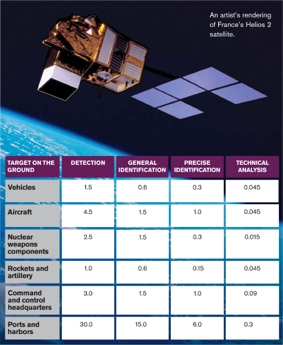
At the resolution given for “general identification,” analysts are able to determine, for example, whether a vehicle is a truck. At the level of “precise identification,” analysts can identify an aircraft as an F-16. And at the level of “technical analysis,” analysts can determine equipment specifics.
SOURCE: YAHYA A. DEHQANZADA AND ANN M. FLORINI, SECRETS FOR SALE: HOW COMMERCIAL SATELLITE IMAGERY WILL CHANGE THE WORLD (WASHINGTON, D.C.: CARNEGIE ENDOWMENT FOR INTERNATIONAL PEACE, 2000).
The decisions taken by France, Israel, Japan, and other nations to deploy their own reconnaissance satellites were based on their individual national security requirements and will provide individual national benefits. But just as individual market choices have implications for the economy as a whole, the impact of the proliferation of space reconnaissance capabilities produces collective outcomes. France, Germany, and Italy have recognized that they can use their individual reconnaissance programs to create a European reconnaissance capability to support the development of an autonomous European capacity for decision making and crisis management. As a result, the Common Operational Requirements for a European Global Satellite Observation System, agreed to by those nations, guarantees that each has access to all satellite reconnaissance systems developed by any of them. 30
A Saturn 5 rocket at the Johnson Space Center in Texas.

DSS-14 Deep Space Network Antenna in California.

Further, the worldwide constellation of spy satellites makes the task of a nation seeking to hide certain activities–whether it is China moving troops or missiles to locations near Taiwan, Iran constructing a nuclear facility, or Pakistan preparing for a missile or nuclear test–far more difficult than in the past. With a plethora of reconnaissance satellites passing over a target throughout the days and weeks, the amount of time a nation can count on not being observed has shrunk considerably from what it was during the Cold War. The transparency that the proliferation of reconnaissance satellites was expected to bring is far closer to a reality than it was a decade ago. Such transparency can serve to increase stability by reducing the chance of successful surprise attack as well as by providing reassurance in tense times to adversaries who would prefer to avoid war–just as it did for the United States and the Soviet Union.
Indeed, the widespread proliferation of space reconnaissance capabilities has opened the door to a series of innovative proposals. Gaurav Rajen, a visiting scholar at Sandia National Laboratories, has suggested that India and Pakistan engage in cooperative remote sensing projects as a way to reduce political tensions and minimize the risk of misperceptions during times of crisis. 31 The South China Morning Post reports that surveillance satellites could help to avoid conflict over the Spratly Islands, which are claimed by China, Taiwan, Brunei, Vietnam, Malaysia, and the Philippines: “Structures built on the reefs by any of the rival claimants could be discovered early during the construction process. At present, occasional long-range reconnaissance flights conducted by aircraft [would] detect the Spratly constructions only after they have been built.” 32
Hui Zhang, a research associate at Harvard's Kennedy School of Government, has argued that commercial high-resolution satellite images can strengthen International Atomic Energy Safeguards. At resolutions of 1 meter, he notes, it is possible to identify buildings and structures that would be characteristic of uranium-enrichment facilities and heavy water-production plants. Even the telltale signs of hidden, underground facilities can be observed from orbit. For instance, although Russia's Krasnoyarsk-26 plutonium facility was built inside a granite mountain, “the discharge point of the cooling water could be detected by visible photos through the absence of ice on the [nearby] river in the wintertime.” 33
Of course, the widespread proliferation of space reconnaissance capabilities also increases the chances that unfriendly nations will join the spy satellite club. Just as there is concern that Pakistan's nuclear weapons might fall into the wrong hands if the present regime were to be toppled, so too one day might Pakistani spy satellites wind up in the wrong hands–with their imagery fed to terrorist groups planning attacks in the United States, Europe, the Middle East, or to adversaries in the midst of a war.
In the case of Iran, reconnaissance satellite technology is already in the wrong hands. The country has placed in orbit the Russian-built Sina-1 (which the government describes as a “research satellite”) with a resolution of 50 meters (164 feet). Iran is scheduled to launch a 70-kilogram (132-pound) telecommunications satellite code-named Mesbah (Lantern) into a 900-kilometer (560-mile) orbit during 2006. 34 As Iran develops satellites with better resolution, it is not farfetched to imagine it becoming a full-fledged member of the space reconnaissance club before the decade is over.
Such scenarios are a driving force behind U.S. ambitions for “Space Control”–the ability to protect orbital assets and to deny other countries the ability to maintain eyes in the sky. But in a world where the space surveillance club is steadily growing, the United States might have to become accustomed to sharing Earth's orbit with some unwelcome members.
BEST OF THE BULLETIN ARCHIVE: Spy satellites
↗
↗
↗
For these articles and more, visit the online Bulletin Archive at www.bulletinarchive.org.
Footnotes
1.
Joseph Fitchett, “Now France, Too, Spies Aloft in a Challenge to American Supremacy,” International Herald Tribune, July 5, 1996.
2.
Michael Rotem, “Spy Satellite for Arab Emirates ‘Serious Threat,’” Jerusalem Post, November 19, 1992.
3.
Quoted in Lt. Col. Brooks L. Bash, “Air-power and Peacekeeping,” Airpower Journal, Spring 1995.
4.
American Embassy Paris to State Department, Subject: Conversation with Christian Fayard (Centre National d'Etudes de Telecommunications) on January 22, 1965, at the CNET, January 23, 1965, Record Group 59, Box 1629, 1965-1966, Testing and Detection, National Archives and Records Administration, College Park, Maryland.
5.
“French Propose Reduced Defense Spending,” Aviation Week and Space Technology, September 27, 1982, p. 22; “French to Propose Satellite Imaging System,” Aviation Week and Space Technology, July 9, 1984, p. 61.
6.
Peter B. de Seiding, “Joxe: Spy Satellite Essential for France,” Space News, May 13, 1991, pp. 1,20.
7.
Quoted in Daniel Keohane, “Making Progress in Space–The European Union's Final Frontier,” European Voice, June 2003.
9.
Arianespace news release, “Mission Update: France's Helios IIA Military Observation Payload To Be Launched December 10 on Flight 165,” November 18, 2004; Martin Walker, “Walker's World: Spy Satellites and Power,” United Press International, December 22,2004.
10.
E. L. Zorn, “Israel's Quest for Satellite Intelligence,” Studies in Intelligence, Winter-Spring 2001, p. 37.
11.
Ibid, pp. 35-36.
12.
Ibid; “Israeli Satellite Is ‘Threat,’ Say Arabs,” Jane's Defence Weekly, October 1, 1988, p. 753; “Israel Launches Second Offeq,” Jane's Defence Weekly, April 14, 1990, p. 678; Daniel Williams, “Israel Launches Satellite: Spy Role Rumored,” Los Angeles Times, April 4, 1990, p. A9; Joel Bnnkley, “Israel Puts a Satellite in Orbit a Day after Threat by Iraqis,” New York Times, April 4, 1990, p. A6; Neil Munro and Barbara Opall, “Israeli Spy Satellite May Be Imminent,” Space News, March 11, 1991, p. 21.
13.
Phillip S. Clark, “Israel's Offeq-3 and the EROS Satellites,” Journal of the British Interplanetary Society, no. 55, 2002, pp. 193-200; John Simpson, Philip Acton, and Simon Crowe, “The Israeli Satellite Launch,” Space Policy, May 1989, pp. 117-128; Craig Covault, “Israel Launches Recon Satellite, Pushes Global Space Marketing,” Aviation Week and Space Technology, June 3, 2002, pp. 24, 26.
14.
15.
Steven Erlanger, “Israel Loses a Satellite That Was Meant to Spy on Iran,” New York Times, September 7, 2004, p. A12; Barbara Opall-Rome, “Israeli MoD May Seek Emergency Funds to Replace Ofeq-6,” Space News, September 13, 2004, p. 6.
16.
David E. Sanger, “Tired of Relying on U.S., Japan Seeks to Expand Its Own Intelligence Efforts,” New York Times, January 1, 1992, p. 6.
17.
Joan Johnson-Freese and Lance Gatling, “Security Implications of Japan's Information Gathering Satellite System,” Intelligence and National Security, Autumn 2004, pp. 538-552.
18.
Ibid; Axel Berkofsky, “Look up Mr. Kim: Japan's Spy in the Sky,” Asia Times, January 15, 2003; “Japan Sets Date for Launch of Space Facilities,” Space News, March 3, 2003, p. 17; James Brooke, “Japan Launches Spy Satellite Despite North Korean Threats,” New York Times, March 28, 2003, p. A8.
19.
Johnson-Freese and Gatling, “Security Implications of Japan's Information Gathering Satellite System”; “Blurred Vision,” Aviation Week and Space Technology, July 14, 2003, p. 21; Berkofsky, “Look up Mr. Kim: Japan's Spy in the Sky”; “Japan Launches Spy Satellite,” Associated Press, March 28, 2003; “Keeping Secrets,” Aviation Week and Space Technology, April 21, 2003, p. 17.
20.
Doug Struck, “Japan to Launch Spy Satellites,” Washington Post, March 26, 2003, p. A14; Brooke, “Japan Launches Spy Satellite Despite North Korean Threats.”
21.
“Japan Postpones Spy Satellite Launch,” Agence France Presse, September 27, 2003; “Japanese Recons Delayed,” Aviation Week and Space Technology, October 6, 2003, p. 33.
22.
Peter B. de Seiding, “DGA Unsure of Strategy for Next Generation of Satellites,” Space News, September 5, 2005, p. 11; Peter B. de Seiding, “French Military Considers High Orbits for Imaging Satellites,” October 4, 2004, p. 6; Pericles N. Zorzovilis, “Greece to Join Nations Receiving Helios Imagery,” Defense News, April 4, 2005, p. 18.
23.
Opall-Rome, “Israeli MoD May Seek Emergency Funds to Replace Ofeq-6”; “Israel Unveils New Reconnaissance Satellite,” C4ISR Journal, April 2005, p. 12.
24.
Arieh O'Sullivan, “Successful Test of New Rocket Launcher,” Jerusalem Post, July 14,2005.
25.
“Launch of SAR-Lupe Pushed Back Until 2006,” Space News, March 14, 2005, p. 3; Tom Kington, “Italy's Space-Based Radar Set for 2006,” Defense News, April 4, 2005, p. 14.
26.
Peter B. de Seiding, “Spain Studies Options for Military Observation Craft,” Space News, February 21, 2005, p. 10.
27.
Keohane, “Making Progress in Space–The European Union's Final Frontier.”
28.
Joseph Fitchett, “Spying from Space: U.S. to Sharpen the Focus,” International Herald Tribune, April 10, 2001.
29.
Vivek Raghuvanshi, “Indian Aerospace Command to Operate Military Satellites,” Space News, April 5, 2005, p. 24; “Pakistan Plans to Build Remote Sensing Satellite,” Space News, August 29, 2005, p. 3.
30.
Zorzovilis, “Greece to Join Nations Receiving Helios Imagery.”
31.
Gaurav Rajen, “Fostering Nuclear Transparency in South Asia through Cooperative Remote Sensing Projects,” Disarmament Diplomacy, March/April 2002.
32.
Glenn Schloss, “Satellites of War … and Peace,” South China Morning Post, September 3, 2001.
33.
Hui Zhang, Strengthening IAEA Safeguards Using High-Resolution Satellite Imagery, Symposium on International Safeguards: Verification and Nuclear Material Security, Vienna, Austria, 2001.
34.
“Iran to Launch First Space Satellite in 2006,” Space Daily, July 21, 2005.