
Abstract
Artificially triggered lightning experimental data from Guangdong Comprehensive Observation Experimental Base on Lightning Discharge (GCOELD) was applied to analyze the propagation effect of lightning electromagnetic field along the real ground surface. The accuracy of the finite-difference time-domain (FDTD) on correcting lightning location system (LLS) errors was validated compared with the Elevation Model (EM). Results show that the wave-shape and time-delay of electromagnetic fields can be significantly affected when they propagate over the real ground surface. The time-delay of the field waveform become larger with an increasing roughness. The wavefront electric field is enhanced due to the reflection and variant of the wave when lightning waves propagate across the high and sharp terrain. Near the lightning strokes, the peak of vertical electric value decreases significantly with the electrostatic shielding effect. The max time delay calculated by FDTD is 8.34 μs; while that by EM is 6.55 μs. In the selected nine lightning stroke points, eight are positively revised by EM, and five by FDTD. Both FDTD and EM can be used on LLS error revision caused by the real ground surface around GCOELD, although EM is more efficient than FDTD in this case.
Introduction
Plenty of research has concentrated on the effect of the propagation of lightning electromagnetic fields over different surface types and the revision of time errors on the time of arrival (ToA)-based LLS [1–5]. The accuracy of the location obtained by ToA techniques can be affected by effects resulting from the field propagation over ground of finite conductivity [6–10].
The effect of the propagation of lightning electromagnetic fields over a rough surface has drawn more attention. For example, Soto et al. [11,12] present the finite-difference time-domain (FDTD) calculation of lightning electromagnetic fields for the lightning discharge striking the top of cone-shaped mountain. Paknahad et al. [13] present a similar configuration, the finite-element method simulation, for both above-ground and underground fields. The lightning electromagnetic fields could be affected by a non-flat ground configuration.
In terms of the characteristics of lightning electromagnetic field propagation, Schulz et al. [14] revised location errors by using the Elevation Model (EM) and considered the lightning location system (LLS) time errors caused by the elongation of propagation paths occurred as electromagnetic waves propagate along the irregular ground surface. Zhang et al. [15] revised time measurement errors induced by the ground surface by introducing a random parameter to represent the ground surface but have not considered the actual ground surfaces of different regions. Zhang et al. [5] modeled rough surfaces using two-dimensional (2-D) fractal methods, adequately considering the chromatic dispersion induced by soil conductivity and the reflection effect induced by surface corrugations. Their research has discussed the characteristics of lightning propagation across ground surfaces. Li et al. [16–18] further analyzed the propagation effects on lightning radiated electromagnetic fields over hilly and mountainous terrain, and they evaluated the time delay error in ToA techniques. Hou et al. [19] applied FDTD to research the characteristics of lightning propagation across mountains and revealed that mountain height and the inclination angle have a significant effect on the lightning-radiated electromagnetic fields for both the close and the far observing distances. Huang et al. [20] used FDTD to further study the real landform rugged surface for the first time for lightning electromagnetic fields and the influence of LLS. Zhang et al. [21,22] analyzed the rough sea and the real ground surface effect on lightning electromagnetic fields, and applied improved EM to evaluate LLS errors.
In general, two approaches can be primarily used in correcting LLS errors caused by the real ground surface. One is EM that considers the time errors caused by signal path elongation and surface impedance with the real ground surface. The other is FDTD algorithm which is based on full-wave quantitative numerical methods. However, the accuracy and efficiency of these approaches have not been studied. Therefore, in this study, FDTD is used to research the characteristics of artificially triggered lightning electromagnetic fields when propagate along real ground to further validate the accuracy of FDTD on correcting LLS errors caused by the real ground surface. The comparative analysis for the effectiveness of EM and FDTD is established.
Obtained data
Artificially triggered lightning experimental data
The experimental data of artificially triggered lightning events are observed from the Guangdong Comprehensive Observation Experimental Base on Lightning Discharge (GCOELD), located in Conghua, Guangdong, China. The details on the measurement sensors and instrumentation with GCOELD can be found in Zhang et al.’s [23] study.
Artificially triggered lightning events observed in the summer of 2017 are used as the control samples for Guangdong-Hong Kong-Macao lightning location system (GHMLLS). During summer 2017, strong atmospheric convection and frequent lightning activities attribute to 16 successful lightning events, with 6 lightning events that identify return stroke, 36 return strokes in total (Table 1).
Observation data based on triggered lighting in summer 2017
Observation data based on triggered lighting in summer 2017
GHMLLS has been jointly constructed by the meteorological department of Guangdong, Hong Kong and Macao since 2005. GHMLLS uses ToA technique to calculate lightning locations, and each sensor determines the ToA of the stroke radiated field pulse using GPS synchronized clock [23]. The Ls-700X series of Vaisala companies are adopted in the sensor station, which detects both the cloud flash and the ground flash. The theoretical detection effect of cloud flash is about 40%–50% [24]; that of ground flash is about 93% [25]. In GHMLLS, four detection stations can be used to detect the ground flash around GCOELD (Fig. 1).
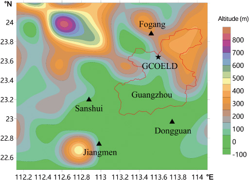
Locations of the detection stations and real terrain around GCOELD.
This study uses the Shuttle Radar Topography Mission (SRTM) data to construct models of actual ground surfaces. SRTM data is generated by joint measurements between the USA’s National Aeronautics and Space Agency (NASA) and the USA’s National Imagery and Mapping Agency (NIMA). The measurement data covers the entirety of Chinese territory at a spatial resolution of 1 arc-second (approximately 30 m at the equator), and its mean-square root of height (RMSH) is generally accurate to 10–25 m, with data resolutions of 1° (approximate 30 m at the equator) [26]. The International Centre for Tropical Agriculture (CIAT) uses a new interpolation algorithm [27] to obtain SRTM ground surface data, which is adept with filling in holes in SRTM data. CIAT data is obtained from the Geospatial Data Cloud website (https://www.gscloud.cn), maintained by the Computer Network Information Centre, Chinese Academy of Sciences. Figure 2 demonstrates the 2-D cross-section of the topographic map along the direct path between the lightning stroke point and LLS detection station.

2-D cross-section of the topographic map along the direct path between the lightning stroke point and the LLS detection station.
Elevation modeling
Three effects influence the accuracy of LLS: 1) time errors due to the elongation of the propagation path of the signals caused by terrain comparing to the ideal propagation path over the ground surface; 2) time errors introduced by a propagation velocity that is less than the speed of light due to finite ground conductivity; 3) time errors due to an incorrect calculation of the so-called onset time. EM is a LLS revision model which eliminates the elongation of the propagation path on the terrain mountain [14]. The elongation path L caused by terrain is approximately calculated as:
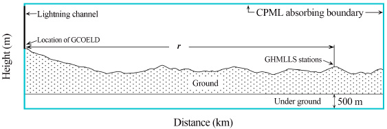
Configuration of the 2-D FDTD model for the real rough surface (r is the distance between GHMLLS stations and GCOELD).

Actual lightning stroke points (artificially triggered lightning) and the lightning positions observed by LLS.

Real terrain from lightning strike point to observation stations (serial number: T167-RS3). (a) Dongguan Station, (b) Fogang Station, (c) Jiangmen Station, (d) Sanshui Station.
FDTD is used to analyze the effect of field propagation along the actual ground surface and correct LLS errors. As shown in Fig. 3, the FDTD modeling is based on 2-D spherical coordinates with the sector region defined by the center of the Earth. Note that the model itself naturally considers the Earth curvature when lightning electromagnetic fields propagate along the Earth’s curved real ground surface. The lightning return stroke channel is modeled using MTLL (modified transmission line linear model with linear decay with height) [28] in our FDTD model. The working space of 2-D FDTD is 150 km × 10 km. The space step is Δx = Δy = 50 m. The time increment is set to 8.34 μs. Ground conductivity is 𝜎 g = 0.001 S/m; relative permittivity is 𝜀 r = 10. The convolutional perfectly matched layer (CPML) absorbing boundaries are used for the upper and right boundaries in Fig. 3.
Analysis
The evaluation of LLS errors using EM
In order to validate the effectiveness of EM, the experimental data of artificially triggered lightning events with GCOELD is used to represent the actual lightning strike points. There are thirty-six return stroke samples in total. As some return strokes have the same location points observed by LLS, nine return strokes are selected as typical ones. Lightning location points observed by LLS are represented simultaneously, which are unrevised by LLS errors by the ground surface (Fig. 4). It can be seen that LLS errors range from about 300 m to 1000 m. Figure 5 shows the real terrain from lightning strike point to Dongguan, Fogang, Jiangmen, and Sanshui Station. The elongation paths between lightning stroke points observed by LLS and each station are analyzed. The time delays caused by the real ground surface correspondingly are shown in Table 2 (assuming the lightning propagation speed 𝜈 = 3 × 10⁸ m/s). The elongation paths between lightning stroke points observed by LLS and each station range from about 1000 m to 2000 m: the max time delay is 6.55 us.
Arrival times corresponding to peak lightning waveform and time delays comparing to perfect ground by FDTD
Arrival times corresponding to peak lightning waveform and time delays comparing to perfect ground by FDTD
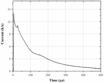
Waveform of the current at the lightning channel base.
Figure 6 shows the current waveform at the base of the lightning channel according to the waveform characteristic and average current peak measured in artificially triggered lightning. Figures 7–9 illustrate the computed waveform of vertical electric field (Fig. 7), horizontal field (Fig. 8) and azimuthal magnetic field (Fig. 9) when lightning strokes point (serial number: T167-RS3) propagate to four observation stations along the real ground surface path. The red curves represent the lightning electromagnetic waveform when lightning electromagnetic fields propagate along the rough surface (the real ground surface path is seen in Fig. 10). The blue curves represent the lightning electromagnetic waveform when lightning electromagnetic fields propagate along the plat ground (the ground soil parameters are 𝜎 g = 0.001 s/m; 𝜀 r = 10).

Lightning vertical electric fields when lightning stroke point (T167-RS3) propagate to observation stations along the real ground surface path. (a) Dongguan Station, (b) Fogang Station, (c) Jiangmen Station, (d) Sanshui Station.

Lightning horizontial electric fields when lightning stroke point (T167-RS3) propagate to observation stations along the real ground surface path. (a) Dongguan Station, (b) Fogang Station, (c) Jiangmen Station, (d) Sanshui Station.

Lightning Azimuthal magnetic fields when lightning stroke point (T167-RS3) propagate to observation stations along the real ground surface path. (a) Dongguan Station, (b) Fogang Station, (c) Jiangmen Station, (d) Sanshui Station.

Actual surface height along the direct path between the lightning stroke point and the LLS detection station. (a) Dongguan Station, (b) Fogang Station, (c) Jiangmen Station, (d) Sanshui Station.
The real propagation path between lightning stroke points and observation stations is relatively complex. The degree of corrugation roughness varies greatly with different paths. The real ground surface could influence the amplitude and the rise-time of the electromagnetic field waveform. The waveform is distorted in various degrees with different real ground surface paths between lightning stroke point and station. Compared with the perfect ground, the peak value of electromagnetic fields distorts and the rise-time of electromagnetic field delays. In order to analyze waveform distortion, Figs 9 and 10 show the spatiotemporal evolution characteristics of the vertical electromagnetic field for lightning striking the flat ground and irregular real ground. In Fig. 11, the red points on the Distance-axis represent the location of observation stations. As Fig. 11a shows, there are two field regions, the red part being with a positive field value while the blue part being negative.

Spatiotemporal evolution characteristics of the vertical electric field for lightning stroke point propagate along the flat ground (left images: a; c; e; g) and propagation to Dongguan Observation Station along the real ground surface path (right images: b; d; f; h).
In this study, the upward electric field is considered to be positive. In Fig. 11d, the wave propagates along the Earth’s surface, which leads to the rise-time delay. The rise-time delay could lead to LLS errors when using the ToA method. The wavefront electric field is enhanced due to the reflection and variant of the wave when lightning waves propagate across the high and sharp terrain (Fig. 11f; 11h). The observation station vertical electric field components are the superposition of the incident wave from lightning strike point and the reflected wave at the transition, leading to the increase of electric field peak value. The lightning-radiated field includes the electrostatic, induction and the radiation field. Near the lightning strokes, there is mainly electrostatic field. Induction field and radiation field increase with further observation distance. In Fig. 12b, Fogang Station is near to the lightning stroke. The vertical electric field is mainly composed of electrostatic field components. Based on the method of image charges in physics, a high and sharp terrain can make electrostatic shielding effect. The peak of vertical electric value decreases largely (Fig. 12b). While Dongguan, Jiangmen and Sanshui Stations are far from lightning strokes, the vertical electric field mainly consists of the induction field, the radiation field, and features with less distortion in peak value.

Spatiotemporal evolution characteristics of the vertical electric field when lightning stroke point propagate to observation stations along the real ground surface path. (a) Dongguan Station, (b) Fogang Station, (c) Jiangmen Station, (d) Sanshui Station.
The rise-time delay caused by the real ground surface could lead to LLS errors. FDTD is used on correcting LLS errors caused by the irregular real ground surface. EM is used as a contrast in order to validate the accuracy of FDTD.
Artificially triggered lightning events data with GCOELD is used to represent the actual lightning strike points and validate the effectiveness of FDTD and EM. There are thirty-six return stroke samples in total. As some return strokes occur in the same location points observed by GHMLLS, nine return stroke points are selected typically. Lightning location points observed by GHMLLS are represented, which are unrevised by the position errors by the ground surface (Fig. 4); the lightning position errors range from about 300 m to 1000 m.
The arrival time of lightning horizontal magnetic fields when lightning strokes propagate along the real ground surface and time delays compared with flat ground by FDTD are listed in Table 2. The time delay in each station ranges from about 4 μs to 8 μs. The time delays calculated by FDTD are larger than that of EM. The max time delay calculated by EM is 6.55 μs, while FDTD is 8.34 μs.
The elongation paths between lightning stroke points observed by GHMLLS and each lightning detection station are analyzed. The time delays caused by the real ground surface correspondingly are shown in Table 3 (assuming the lightning propagation speed 𝜈 = 3 × 10⁸ m/s). The elongation paths between lightning stroke points observed by GHMLLS and each station range from about 1000 m to 2000 m; the max time delay is 6.55 μs.
The lightning stroke points with GCOELD actual lightning observed by LLS and revised by FDTD and EM are illustrated in Fig. 13. The method, the time of the peak value of the field, is used to estimate lightning strike points for ToA [29]. Note that the revised stroke points are closer to the actual stroke point in general, especially by applying EM. In the nine selected lightning stroke points, eight are positively revised by EM; five are positively revised by FDTD. In most cases, EM has a better performance on correcting lightning stroke point errors caused by the real ground surface. Nevertheless, FDTD can outperform EM in a few cases. The reason could be interpreted as the fact that the terrain of test areas is relatively flat, and errors due to terrain conditions is minimal. The positioning error between actual lightning stroke points and lightning positions observed by LLS includes not only the terrain errors, but also the time clock recording error of the positioning station. In the comparison of nine samples, when the positioning error is large, the error is mainly affected by terrain conditions, then EM is effective due to its advantage in terrain error correction. When the positioning error is minimal, FDTD has better accuracy because it is propagated by simulating the real electromagnetic field. On the contrary, EM becomes less effective due to over-correction.
Elongation paths and time delays between lightning stroke points observed by LLS in each station by EM
Elongation paths and time delays between lightning stroke points observed by LLS in each station by EM

Lightning stroke points with GCOELD actual lightning observed by LLS and revised by FDTD and EM.
FDTD is employed to present the lightning propagation effect along the real irregular ground surface. The real ground surface path between lightning stroke point and observation station has a significant influence on electromagnetic field waveform. Compared with the perfect ground, the peak value of electromagnetic fields distorts and the rise-time of electromagnetic field delay. The wavefront electric field is enhanced due to the reflection and variant of the wave when the lightning wave propagates across the high and sharp terrain. When the observation station is near the lightning stroke, the peak of vertical electric value decreases largely with the electrostatic shielding effect. When the observation station is far from lightning stroke, the vertical electric field mainly consists of induction field, radiation field, and less distortion of peak value. The reason why the rise-time delays is that the wave propagates along the Earth’s surface.
EM is employed as a contrast on validating the accuracy of FDTD to correct LLS errors. The time delays caused by the real ground surface are listed. Results show that the elongation paths between lightning stroke points observed by LLS and each lightning detection station range from about 1000 m to 2000 m. The time delays calculated by FDTD are larger than that of EM. The max time delay calculated by FDTD is 8.34 μs; while EM is 6.55 μs. 8 of 9 lightning stroke points are positively revised by EM; 5 points are positively revised by FDTD. EM is more suitable in application on correcting lightning stroke point errors caused by the real ground surface. It could be widely tested in LLS error revision caused by the real ground surface.
For limitations, the ground surface of the experimental area is relatively smooth, and the location error of LLS is small. Besides, the parameters in FDTD have a great impact on correcting LLS errors caused by the irregular real ground surface. The efficiency results of EM and FDTD could fluctuate with different regions and real ground surfaces. In future studies, it is necessary to validate correcting algorithms referring to more extensive artificially triggered lightning experimental data, with diverse topographic conditions.
Footnotes
Acknowledgements
This study was financially supported by the 2019 Key Research Items of Shandong Meteorological Bureau (Grant No. 2019SDQXZ08) and the 2021 Shandong Natural Science Youth Fund (Grant No. ZR2021QD023).