
Abstract
Today, with the rapid development of urbanization, the ecological and environmental problems of the city have become increasingly serious and have become the focus of the world. The most important issue facing the majority of ecological workers is how to apply the theory of ecology to solve today’s problems. The various environmental problems faced in urban life and the sustainable development of the city’s ecological civilization. How ecological planning is used to coordinate the relationship between people and the natural environment and natural resources is increasingly gaining attention and expanding the range and scope of its applications. However, as an ecological suitability analysis based on ecological planning, many analytical methods and systems are still being explored and developed due to the geographical complexity and factor diversity involved. In recent years, with the rapid development of computer hardware and software technology, pattern recognition has received more and more attention, pattern recognition and image processing technology has become more and more perfect, and has been successfully applied in more and more fields. This thesis begins to focus on the urban ecological suitability content based on pattern recognition technology and image processing. The main contents of this thesis include: introducing the background of urban ecological suitability and the status quo of ecological suitability analysis and existing research methods. According to the structure of the urban ecosystem and the national standards for the construction of ecological systems and ecological cities, an indicator system for ecological suitability evaluation is established. A pattern recognition system and common pattern recognition and image processing methods are introduced. Based on some common evaluation methods and models, the pattern recognition technology theory and image processing technology are introduced into the urban ecological suitability analysis. Based on the image system theory and vector projection principle, the ecological suitability analysis is established. Associated projection model. The model considers the evaluation sample and the quality standards at each level as vectors, and respectively projects the same vector ideal. Based on establishing the ecological suitability evaluation index system and standards, the ecological suitability was evaluated by using the model.
Introduction
In the process of urban development, urban ecological problems have been continuously produced and developed. Since the early 1970 s, China has regarded cities as the focus of environmental protection work. In dealing with the continuous development of cities and the relationship between urban ecological protection and ecological restoration, basic forms have been formed. Important measures [1]. According to the reality of urban ecology in China, the ecological environment evaluation system of construction projects is proposed [2]. The implementation of this system is an effective way to avoid adverse consequences for the ecological environment due to development projects and major economic mistakes. It is also an active measure for China to correctly handle urban development and ecological protection, and will undoubtedly play an active role in urban ecological protection. However, practice has proved that it is far from enough to solve the environmental impact assessment of a single development and construction project. It is difficult to determine the positive impact of the urban ecological environment. According to this evaluation method, it is difficult to determine the positive impact of the development project on the urban ecological environment [3]. The rational layout of the project, etc., will inevitably not affect the urban ecological environment. The fundamental reason is that the city is not studied and discussed as a special artificial ecosystem, which will greatly hinder the improvement of the urban ecological environment and offset the development. The economic benefits of the event.
To this end, to coordinate urban development and urban ecological relations, solve urban ecological problems, improve urban ecological quality, and achieve the balance of urban ecosystems, it is necessary to change the current evaluation of the ecosystem suitability of urban development, that is, to propose urban development. The one-way evaluation based on ecological impact should be replaced by a comprehensive evaluation of urban ecosystem evaluation of urban development and urban ecological relationship [4]. The evaluation content system has to be comprehensively considered by the three groups of indicators: urban structure-city function-city coordination degree. The evaluation work must be based on the relationship between urban structure, urban function and urban coordination degree, using systematic methods to identify the main environmental problems that restrict urban development, reveal and evaluate the appropriate structure of urban economic and social systems, and make full use of the regional environment. Features to regulate problems [5].
In the planning process of regional planning, urban master planning, etc., it is necessary to study the ecological relationship between the city and its surrounding environment and regions. Urban or regional ecological planning is also necessary; in the detailed planning and urban design process It is also necessary to study the ecological problems of specific areas. At present, the construction of eco-cities has become the development goal of many cities. Therefore, it is necessary to further explore the application and reference of ecological theories and methods in the field of urban planning [6].
In recent years, with the rise of artificial intelligence, basic research in pattern recognition and sensing technology has brought great development to image processing technology, which will greatly improve the interaction between humans and machines [7, 8]. Pattern recognition is not only a research field with great scientific significance, but also a major key technology that needs to be broken in many practical applications in the digital age of network [9–11].
To realize the eco-city suitability analysis, this paper proposes an urban ecological suitability analysis based on pattern recognition technology and image processing using pattern recognition and image processing techniques. The specific contributions of this paper are as follows: Scan the urban ecological environment map through image acquisition card pattern recognition to observe the entire urban ecological environment. The image is processed by the computer image acquisition processing and control system, and the gray system is substituted and the appropriate degree in the region is identified. Listed the suitability evaluation system, exemplified a certain area and conducted a suitability evaluation analysis and discussion on multiple factors in the area.
Research methods of urban ecological suitability
Traditional ecological city suitability research methods
Optimization technology occupies a very important position in decision analysis. Mathematical models dominate the optimization technology. Due to the complexity of the system, the mathematical model is more and more complicated. It is difficult to master and use, and with complexity. Increase, the distance between the model solution and the actual requirements is also increasing. Mathematical models are not omnipotent. Many factors in decision-making cannot be quantified. Therefore, sometimes people have to return to the starting point and endpoint of decision–the choice and judgment of people. It is necessary to seriously study the law of choice and judgment. This is The background produced. The University of Pittsburgh professor proposed the analytic hierarchy process in the mid-1970 s. The characteristics of the analytic analysis input information is mainly the choice and judgment of the decision-maker. The decision-making process fully reflects the decision-makers simple understanding of decision-making problems based on high school knowledge. It can be used for quantitative analysis without calculating the practical performance of the computer. It can also be a qualitative analysis. Usually the optimization method can only be used for quantitative analysis. Three causal judgments, probabilistic inferences, and systematic inferences, treating the problem as a system belongs to the third.
Planning theory uses more rigorous mathematical calculations to minimize human subjectivity but some decision-making results are difficult for decision-makers to accept. In essence, it tries to make people’s judgments organized. The results are based on the subjective judgment of the person. When the judgment of the decision-maker is distorted by the objective law due to personal preference, the result is unreliable. Therefore, usually the group Judgment method. Although it is still not perfect in theory and has defects in application, it is still regarded as an effective method for multi-objective decision making because of its simplicity and practicality. It is still widely used as an unstructured decision-making method. The current mainstream “earth information system” is a specific spatial information system. It is based on the geospatial database and collects, stores, manages, calculates, analyzes, displays and describes the geographical distribution data of all or part of the Earth’s surface, including the atmospheric space, supported by computer hardware and software systems. Model analysis method, which provides a variety of spatial and dynamic geographic information on time, and establishes a computer technology system for geographic research and geographic decision-making services.
In recent years, most of the technology in China has been used in urban planning and land use. There are not many applications in urban ecology. With the maturity and promotion of technology, the role played by urban ecological planning and evaluation will be getting bigger. According to the specific analysis, the geographic information system has the following characteristics: relying on the computerized technical system, through the data collection, management, analysis, and finally output data products, computer programs can be used to simulate conventional or specialized geographic analysis methods, acting on spatial data., generate useful information and complete more complex tasks. The support of computer systems enables spatial, spatial, and dynamic analysis of complex geographic systems in a fast, accurate, and comprehensive manner. The spatial data composed of three-dimensional elements such as points, lines, faces and bodies of spatial geographic entities are taken as research objects. The geographic model method is used as a means to describe all the data according to the unified geographical coordinates, positioning, qualitative and quantitative. Its technical advantage lies in its data integration, simulation and analysis and evaluation capabilities, which can generate high-level geographic information that is difficult to obtain by conventional methods or common information systems, and realize the simulation and prediction of geospatial process evolution [12].
Research on urban ecological suitability based on pattern recognition technology and image processing
Based on pattern recognition technology and image processing, the main purpose of urban ecological suitability is to apply the pattern recognition system and image processing technology to the analysis of urban ecological gray system suitability.
As shown in Fig. 1, a flow chart of the image acquisition of the urban ecosystem and a flow chart of the pattern recognition gray system are shown. The purpose of the image acquisition device is to accept external excitation and generate a response, and convert the simulated response into a digital signal that can be utilized by the computer. Therefore, the functions and functions of the acquisition device are mainly two, one is to accept the external signal, and the other is to perform analog-to-digital conversion. The image acquisition system can be roughly divided into four parts: a synchronization system, a scanning system, a photoelectric conversion system, and an analog-to-digital conversion system. The synchronization system provides the clock synchronization signal of the entire image acquisition system to synchronize all the components in the system. The motion scanning system is an intrinsic part of the image acquisition system. It realizes the discretization of the spatial coordinates of the sampled image by scanning the entire ecosystem image. And obtaining the light intensity value of each sampling point. The photoelectric conversion system is responsible for converting the optical signal output by the scanning system corresponding to the sampling point attribute into an electrical signal, and providing necessary amplification processing to match the analog to digital conversion system. The electrical signal output by the photoelectric conversion system enters the analog-to-digital conversion system, and is sampled, held, converted, and converted into a digital signal output for storage, display, transmission, and other processing. The entire city’s ecosystem sampling is entered into the system through an image acquisition system to store information through pattern recognition.
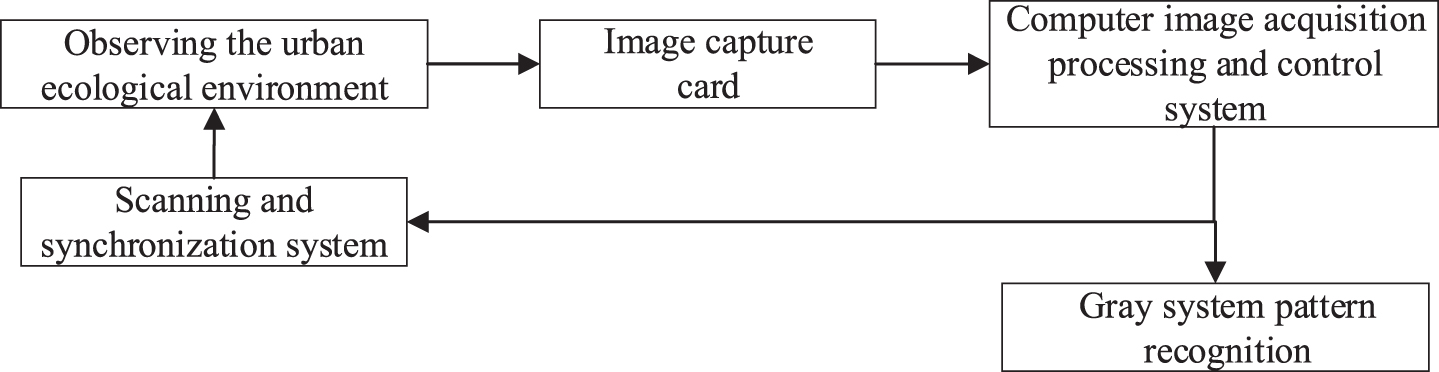
Urban ecological image acquisition and recognition.
A complete pattern recognition system consists essentially of three major components, namely data acquisition, data processing and classification decisions or model matching. When designing a pattern recognition system, you need to pay attention to the definition of the pattern class, the application, the pattern representation, the feature extraction and selection, the cluster analysis, the design and learning of the classifier, the selection of the training and test samples, and the performance evaluation. For different application purposes, the content of the three parts of the pattern recognition system can be very different, especially in the data processing and pattern classification. To improve the reliability of the recognition results, it is often necessary to add the knowledge base to the possible errors. Make corrections or greatly reduce the search space in the model library by introducing constraints to reduce the amount of matching calculations. In this section we simply enumerate the algorithmic process of extracting image features using the SIFT algorithm:
Assuming that a two-dimensional image is I (x, y), its scale space can be represented by the image function and Gaussian convolution:
The definition of the Gaussian kernel is as follows:
Where (x, y) is the pixel of the image; I (x, y) is the image data; σ denotes the scale-space factor and the variance of the Gaussian normal distribution, which characterizes the degree to which the image is smoothed, and the smaller the value, the smoother the image.
To efficiently detect stable matching feature points in the scale space, the DoG operator is generally selected as the detection function. The DoG operator is relatively simple to calculate, has high execution efficiency, and has good stability of detected feature points or regions.
The DoG operator is obtained by the difference of Gaussian kernels of two different scales, which is similar in form to the normalized LoG operator. Let k be the scale factor of the adjacent scale space:
For the ecosystem of the whole city, we use pattern recognition technology to collect the image information of the entire urban ecosystem through the image acquisition system and then analyze the corresponding image according to the pattern recognition technology to analyze the appropriateness. It is embedded in the gray system, and all the information is evaluated by gray clustering and gray statistics through pattern recognition technology and image processing technology. Gray sequence generation is achieved by the action of sequence operators. The grey model is constructed according to the five-step modeling idea. The grey generation or sequence operator is used to weaken the randomness and exploit the potential law. Through the exchange between the gray difference equation and the gray differential equation, the discrete data sequence is used to establish continuous A new leap in dynamic differential equations. Grey prediction is based on quantitative prediction of grey decision making including grey target decision, grey relational decision, grey statistics, cluster decision, gray situation decision and gray level decision. The system in which all the factors and factors in the system are completely unclear is black, and the analysis of the system can only rely on the edge factor. The system in which the relationship between factors and factors within the system and the role are completely clear is white, and the analysis of the system relies entirely on the degree of control of internal factors. The relationship between the factors and factors in the system and the parts with clear, partially fuzzy and partially unknown systems are gray systems. The commonly used functions and mathematical models of the system are analyzed, and the possible multiple results are selected according to the needs. The best one is the conclusion.
The grey relational projection model makes full use of the obtained information, and the results are intuitive and reliable, and can reflect the comprehensive effects of multiple factors acting together on the ecosystem. As in equation (4), X is the original sequence. It calculates the number of related links based on the formula. Besides, in the calculation method, the gray correlation degree comprehensive evaluation method based on pattern recognition is simple and easy to understand, and the gray correlation method does not need a large number of samples, and does not require a classical distribution rule, as long as a representative small sample can be used., the calculation is simple. Therefore, the gray correlation projection model is scientific and effective for multi-index ecological suitability analysis, and has certain promotion and practical value.
The gray recognition system uses coefficients to indicate the extent to which a certain thing belongs to a certain set, assigns different coefficients to different degrees of suitability, and the real interval (0, 1) represents the range of the weight coefficients. u = 1 is the highest level, which means that it is very suitable, and u = 0 is the lowest level, which means it is extremely unsuitable. The real numbers in the interval corresponding to a certain level.
The first step is to determine the boundary or intermediate value of the basic factors of each indicator. The basic factor of each indicator in the ecosystem is the best and the lowest is the minimum.
The second step constructs the weight of the kth basic ecological factor value.
The third step calculates the corresponding value based on the indicator data obtained by the image recognition, and the higher the score value, the better the quality.
It is necessary to point out that the calculation formula for urban ecology is:
In the equation, M represents the average urban ecological index, n the number of ecological factors, and N is the ecological suitability corresponding to each ecological factor.
The suitability index for a single ecological factor is calculated as:
In the equation, W is the weight coefficient corresponding to the ecological factor, and X is the result of the suitability analysis.
In this study, we evaluated an area to measure the ecological suitability evaluation. Referring to the current domestic index system of ecological suitability evaluation of urban construction land, combined with the ecological and environmental characteristics of the study area, and based on the actual situation of the area, the evaluation is shown in Table 1. Its mountainous The hilly area is located in arid areas, landslides and mudslides and other geological disasters, as well as the protection of cultivated land and basic farmland, scenic spots, and other factors, and choose three ecological factors: surface water, land use type, and scenic spots.
Evaluation level of ecological suitability factors for urban construction land
In order to illustrate the processing of the optional images of the ecosystem by the computer image processing and control system, we discuss the preprocessing of the urban ecological image and the graying treatment of the noise image before filtering. Take the original ecological environment map in Fig. 2 as an example. To illustrate the computer image processing and control system for the ecosystem-selectable image processing process, we discuss the preprocessing of urban ecological images and grayscale the image before noise image filtering, we will find Fig. 3 (a) image from the three-dimensional data is reduced to a two-dimensional grayscale image, and the basic information of the image is retained while reducing the information storage space. When we simulate the noise as salt and pepper noise, Fig. 3 (b), using the filtering method to process the noisy image, we find that the result of the denoised image is shown in Fig. 3 (c). The noise is effectively removed, and the image quality is improved. Image signal feature extraction recognition provides good clarity. As shown in Fig. 3 (d), the image binarization results allow us to more easily observe the contour, which is beneficial to the target boundary in the later recognition process.

Original ecological environment.
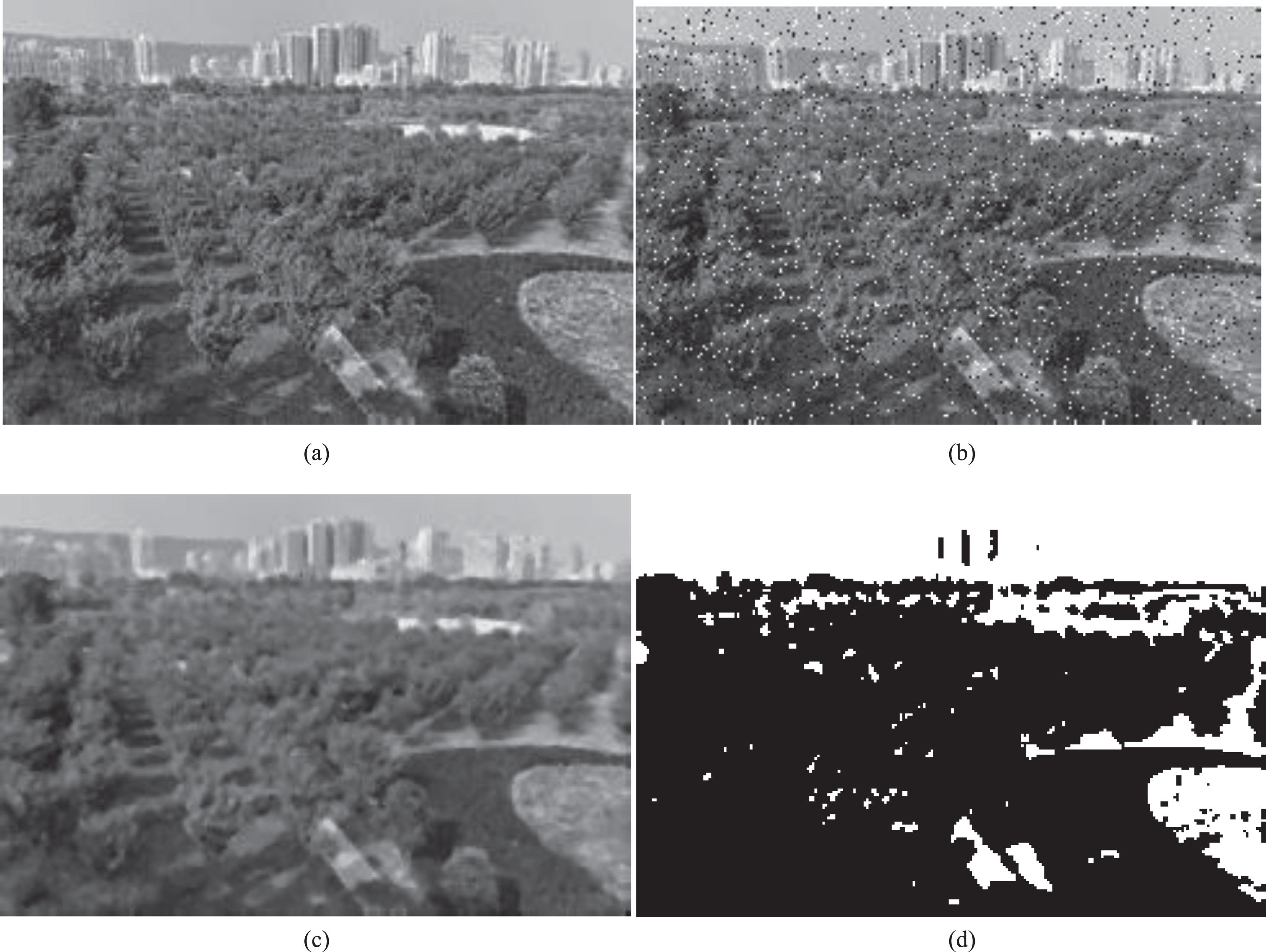
Example of computer image processing: (a) image grayscale; (c) filter processing (b) salt and pepper noise image; (d) binarized image..
After discussing the image preprocessing, we discuss in this part the analysis of the ecological suitability of a region by the gray recognition technology. Based on the actual situation of the whole region, we choose three ecological factors: surface water, land use type and scenic spots. Analysis of ecological suitability evaluation results: Surface water
Regional surface water factor suitability evaluation results
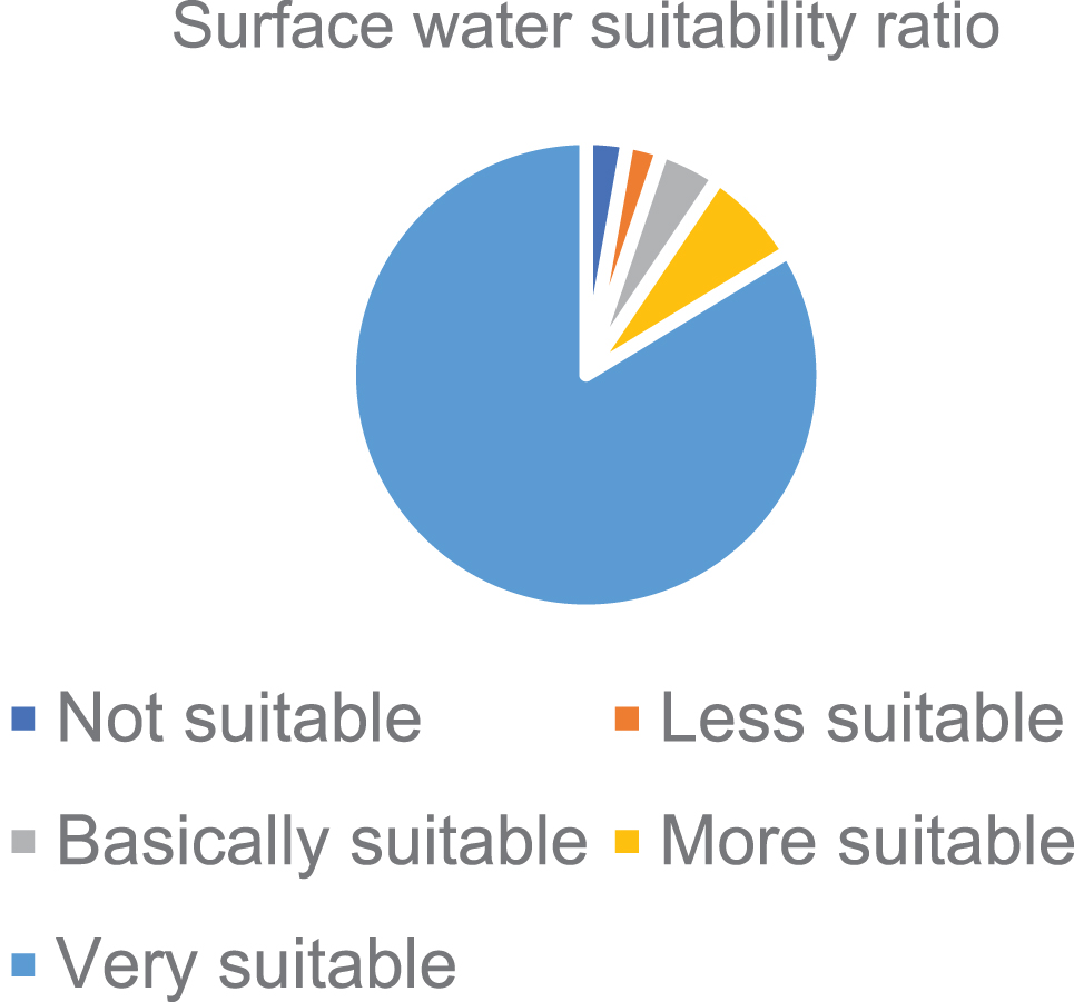
Ecological suitability assessment of surface water factors in the survey area.
Combined with Table 2 and Fig. 4, it can be found that the surface water factors are suitable, suitable, basically suitable, less suitable, and the proportion of the area that is not suitable for the total area is 83.72%, 6.87%, 4.2%, 2.41%, 2.8%. Land-use type
Evaluation results of regional land-use type factor suitability
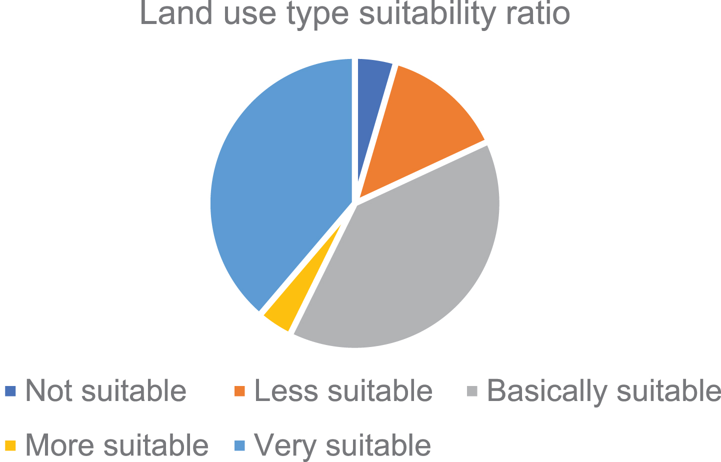
Evaluation of ecological suitability of land use types in the survey area.
Combined with Table 3 and Fig. 5, the result of grey system pattern recognition is analyzed. The land use type factors are suitable, suitable, basically suitable, less suitable, and unsuitable. The area of the total area of the area is 38.78%, 3.92%, 39.22, 13.56%, 4.53%. Scenic spots
Combined with Table 4 and Fig. 6, the result of grey system pattern recognition is analyzed. The scenic spot area factor is suitable, suitable, basically suitable, less suitable, and the area of the area is 52.86%, 8.54%, 12.97%, 13.54%, respectively. 12.08%.
Regional reputation zone factor suitability evaluation results

Evaluation of ecological suitability of scenic spots in survey areas.
In summary, the enlightenment and suggestion of ecological suitability evaluation for eco-city construction: the eco-city in the region should be based on the evaluation basis and ecological basis of construction land, and the project construction should not be carried out in the unsuitable construction area. The urban construction should be in the suitable construction area. And it is basically suitable for site selection within the construction area to avoid high-risk areas of geological disasters, improve urban safety, and reduce the damage of human activities to the ecological environment.
This paper mainly discusses the traditional urban ecosystem suitability analysis method, and discusses the basic technology of pattern recognition and the basic construction of the image acquisition system, the background of urban ecological suitability and the status quo of ecological suitability analysis and existing research method. According to the structure of the urban ecosystem and the national standards for the construction of ecological systems and ecological cities, an indicator system for ecological suitability evaluation is established. A pattern recognition system and common pattern recognition and image processing methods are introduced. Based on some common evaluation methods and models, the pattern recognition technology theory and image processing technology are introduced into the urban ecological suitability. Based on the gray recognition system, we evaluate the regional ecology. On the basis of establishing the ecological suitability evaluation index system and standards, the ecological suitability was evaluated by using the model.
Footnotes
Acknowledgments
This work was supported by National Natural Science Foundation of China: Reserch on Constructing Ecological Gene Identification of Ethnic Traditional Settlement and “Ecological Gene Information Atlas” (No: 71473051) and National Planning Office of Philosophy and Social Science Foundation of China: Study on the Way to Promote the Balanced and Full Development of Southwest Ethnic Areas by Holistic Tourism (18BMZ129).