
Abstract
In order to improve the accuracy and security of encrypted holographic 3D geographic information data acquisition and improve the actual resolution of geographic information files, a blind watermarking algorithm for encrypted holographic 3D geographic information data based on mapping mechanism is proposed. According to the characteristics of the mapping mechanism, a mapping mechanism structure diagram is constructed; Under the mapping mechanism technology, blind watermark data is preprocessed. Then, a watermark embedding operation is performed to obtain the watermark information image, and then a blind watermark that encrypts the holographic three-dimensional geographic information data is extracted. Finally, using the blind watermark signal as input, the blind watermark information is obtained by using the watermark strength, and the holographic 3D geographic data information is segmented and encrypted to complete blind watermark detection. The blind watermark algorithm for encrypting the holographic 3D geographic information data is studied. The results show that the maximum difference between the correlation coefficient of the algorithm in this paper and the correlation coefficient of the unaffected algorithm is only 0.04, which has better anti attack performance, high security, good terrain information collection ability, high data accuracy, and can achieve curvature repair of information data.
Keywords
Introduction
In recent years, with the rapid development of informatization, digitalization and networking, the acquisition, storage, dissemination, use and replication of encrypted holographic 3D geographic information data have become very convenient and fast. Although people enjoy this convenience, it is easy to cause illegal duplication of encrypted holographic 3D geographic information data, and the security of this data is facing serious challenges [1, 2]. At present, most of the distribution management of encrypted holographic 3D geographic information data still stays at the traditional management level for paper maps, and still adopts the methods of application, registration and collection, which makes it difficult to control the direction of data distribution and ensure data security. Therefore, it is impossible to solve the problems of data leakage, illegal circulation, piracy, free use, and illegal profit making, which makes the security problem even more prominent. At the same time, it also leads to a series of problems: due to the inability of security technology to keep up with actual needs, data transmission constraints, encrypted holographic 3D geological information data is difficult to play a role, application departments are difficult to obtain data, and the acquisition accuracy is low, and high-resolution geographic information cannot be obtained, The damage to normal work ultimately leads to damage to the entire industry and affects the development of environmental geographic information systems [3–5].
On the basis of encryption technology and digital watermarking, some scholars have proposed a blind watermarking algorithm to protect the security of encrypted holographic 3D geographic information data. The research on blind watermarking algorithms has attracted widespread attention, and the performance of this algorithm directly affects its subsequent application in protecting encrypted holographic 3D geographic information data. Reference [6] proposed a new digital image blind watermarking algorithm based on the combination of discrete wavelet transform and singular value decomposition. Firstly, the original image is decomposed by wavelet and the low-frequency subbands obtained by wavelet decomposition are divided into blocks, then each block is decomposed by singular value, and then the largest singular value in each block is selected to embed watermark information by quantization method, and the extraction of watermark does not require the original image. The experimental results show that the algorithm has good robustness, but its acquisition accuracy is low. Reference [7] proposed a two-color image blind watermarking algorithm based on Walsh Hadamard transform. In this algorithm, the strong correlation between the energy aggregation function and the transformed frequency domain matrix coefficients is used to embed the digital watermark. First, divide the color host image into R, G and B channels, and each channel is divided into four modules. By studying the frequency domain coefficients, strong correlation can be found between the coefficients in the first row of the frequency domain matrix. Therefore, the digital watermark can be embedded into the matrix block by fine-tuning the above coefficients, and the watermark information can be extracted by the difference between the two coefficients. The simulation results show that the algorithm has good performance in terms of robustness, watermark capacity, and runtime, but its anti attack ability is poor.
Therefore, in order to improve the performance of blind watermarking algorithms, improve the security and acquisition accuracy of encrypted holographic 3D geographic information data, a blind watermarking algorithm for encrypted holographic 3D geographic information data based on mapping mechanism was proposed. Mapping mechanism is a term that refers to the relationship between two sets of elements. Mapping, also known as projection, is often equivalent to a function in geography and related fields. A function is a mapping from a non empty number set to a non empty number set, and it can only be a one-to-one mapping or a many to one mapping. The mapping mechanism should have good performance in the field of blind watermarking algorithm for encrypted holographic 3D geographic information data. It can effectively remove frequency aliasing, has the characteristics of simple operation and easy implementation, and can improve the security and acquisition accuracy of encrypted holographic 3D geographic information data. The feasibility of this algorithm is verified through experiments.
Blind watermarking algorithm for encrypted holographic 3D geographic information data
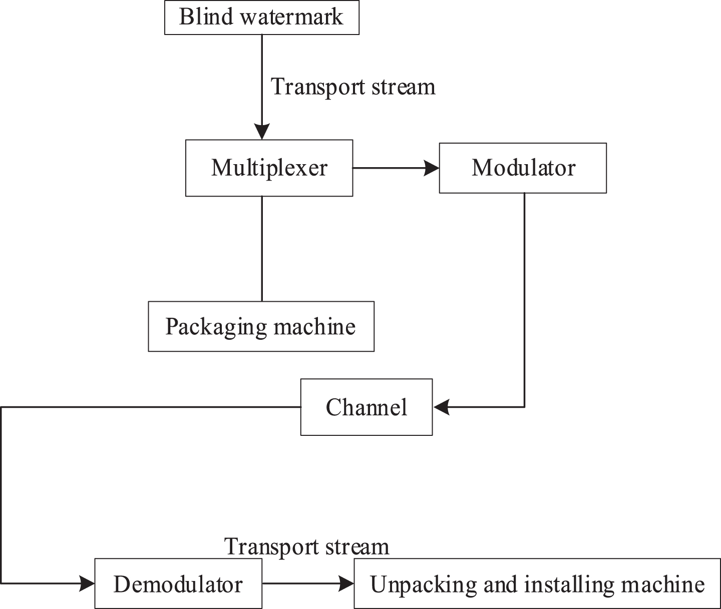
Under the support of the mapping mechanism theory, the blind watermarking algorithm of encrypted holographic 3D geographic information data is researched according to the operation process of data blind watermarking preprocessing, embedding operation, data blind watermarking extraction, and watermark blind detection. The process framework is shown in Fig. 1 below.
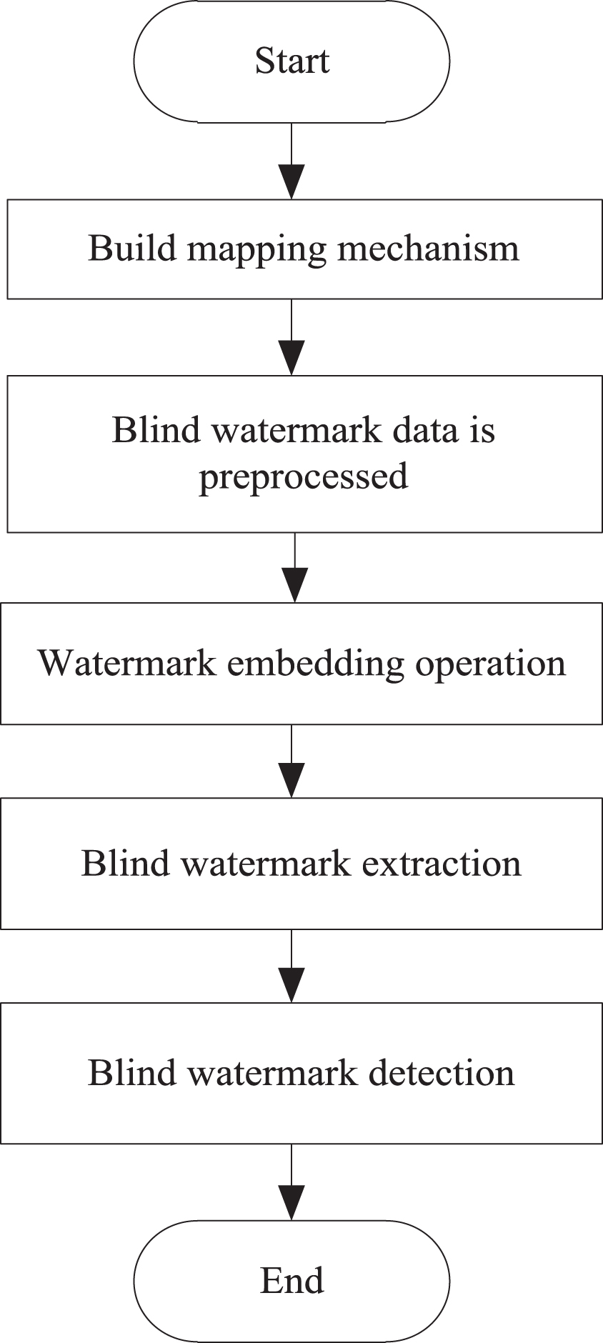
Process framework of blind watermarking algorithm.
The mapping mechanism is a function that can generate elements in two spaces into elements in another space, and it maintains a linear relationship with all parameters.
Set the cyclic group to be described by A1 and A2, the order of the group to be described by the prime number p, and the generator of A1 to be described by q, then the mapping mechanism is expressed as e : A1 → A2, and the following characteristics must be met: Bilinear characteristics. For ∀u, v ∈ A1 and ∀a, b ∈ Z
p
, there are:
In formula (1), Z represents exponential group and M represents bilinear mapping. Computability features. For any u, v ∈ A1, e (u, v) can be calculated in polynomial time. Non degenerative characteristics. If q ∈ A1 exists and e (q, q) ≠1, e is non degenerate. According to the above characteristics, the mapping mechanism structure is shown in Fig. 2.

Mapping mechanism structure.
In Fig. 2, A, B, C and D represent the adjustment unit values respectively, A‘, B‘, C‘ and D‘ represent the modulation order values respectively, and A”, B”, C” and D” represent the modulation mapping values. According to the mapping mechanism structure diagram, the blind watermark data is preprocessed.
When collecting encrypted holographic 3D geographic information data, there are often deficiencies in data quality, standard format, etc. [8, 9]. In order not to affect the data integrity verification effect, it is necessary to preprocess the collected encrypted holographic 3D geographic information data, which mainly includes data cleaning and data conversion [10].
Data cleaning takes a long time, but it is the most critical, mainly in the following aspects: Error encryption holographic 3D geographic information data processing. Classify the information data containing errors. If the input format is wrong, you can use the SQL statement to filter and then correct it; If the input content is wrong, it shall be submitted to the competent business department for correction. Processing of repeated encrypted holographic 3D geographic information data [11]. For this type of data, all fields and values of duplicate records should be exported for confirmation before deletion.
Data conversion refers to the granularity transformation or uniform business rules of different information data, mainly in the following aspects: Differential data transformation. This process is a process of data integration, that is, the data of the same type in different business areas are unified. For example, the fields representing the same meaning are recorded in English in the 3D geographic mapping system [12, 13], but they are reflected in Chinese in the audit procedure. In this case, it is necessary to extract these fields and convert them into the same code. Unify business rules. Some information in the 3D geographic mapping system is usually based on the subjective input of users, which will lead to multiple expressions of content with the same meaning. You can use the third-party tool library in the Python script program to extract keywords (generally provincial and urban information), and then convert them into national administrative division codes and save them in the information database.
After preprocessing the encrypted holographic 3D geographic information data, the rework rate caused by previous input errors can be reduced, and the efficiency of information data integrity verification can also be improved.
Based on the characteristics of the encrypted holographic 3D geographic information data structure, the blind watermark is processed. For blind watermark replacement, the formula is as follows:
In formula (2),
In formula (4), J F represents a given threshold. The mapping model is used to further process the blind watermark image, and the watermark signal features for detection are obtained, which are combined with the effective features of the blind watermark attributes to complete the preprocessing of the blind watermark data.
After completing the above blind watermark data preprocessing, the watermark embedding operation is performed, and the basic block diagram is shown in Fig. 3.
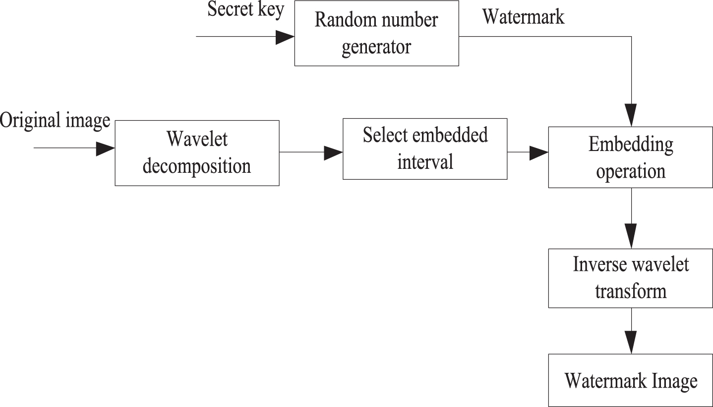
Watermark Embedding Block Diagram.
The specific operation process of this step is as follows: Generate a watermark sequence. Using the key K, a binary random sequence W is generated, with a sequence length of N. Wavelet Decomposition After performing an L level wavelet decomposition on an image with a size of M × M, a pyramid structured subband sequence is formed, which is then segmented into h × h blocks according to the order of spatial resolution from low to high. Next, use the following equation (3) to calculate the mean value of the subband coefficients.
In the formula, c(i,j) (a, b) is the coefficient of the (i, j) block, M is the number of wavelet coefficients for each block, and S Di is the h × h sub blocks.
Then calculate the modulation factor: Calculate the modulation factor as follows: P (i, j) = A + T (i, j) * B, where T (i, j) is defined as follows:
In the formula, A, B, β are constants, where A, B represents the intensity factor. The function of A is to ensure that in the smooth region, when T (i, j) is close to 0, a certain strength of watermark can still be embedded.
(3) Select an embedded interval. The decomposed subbands are scanned line by line into a 1-dimensional vector C, the first N largest coefficient values are found, and their coordinates are sequentially stored in the index matrix I of 1 × N in descending order.
(4) Embedding operations. Let k be a positive integer. According to Fig. 2, if the information “1” is embedded, the coefficient value should be 32k+24. If the information “0” is embedded, the coefficient value should be 32k+8. According to the criterion of minimizing the mean square error between the watermark image and the original image, if X is used to represent the original coefficient value, the embedding result should meet the constraint requirements of the following formula [17].
Embed a watermark. If the watermark information is W (i, j) = 1, adjust the wavelet coefficients according to formula (8):
(5) After embedding the watermark information, inverse wavelet transform is performed, and the resulting image is the watermark information image.
Based on the processing results of the blind watermark data described above, assuming that K represents an object in the encrypted holographic 3D geographic information vector space, the K change type of the dependent object of object L can be obtained according to the dependency mapping of topology, time and attributes in the encrypted holographic 3D geographic information, and all change types will be operated in the execution mode consisting of three commands: update, add, and delete. In the encrypted holographic 3D geographic information vector space, the data extraction method is shown in Fig. 4.
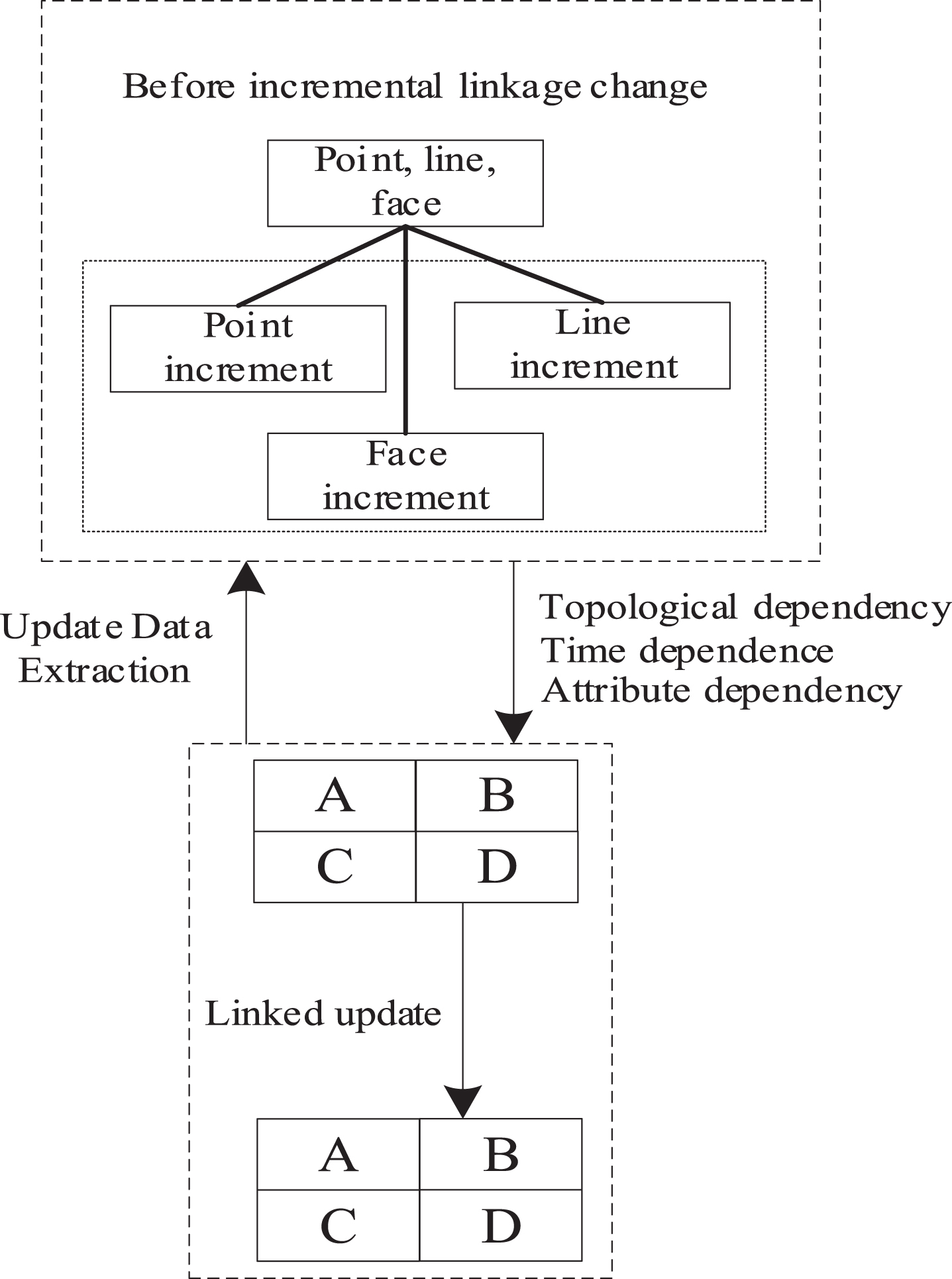
Schematic Diagram of Data Extraction Method.
The image information of an object in the extracted large encrypted holographic 3D geographic information before linkage update is composed of points, lines, surfaces and attributes [18]. Before linkage change, the object to be changed can be identified and marked with the change type. After extracting the points, lines, surfaces and attribute increments after the linkage update object, the transformation type of linkage incremental update data object is obtained by using topology, time, attribute and other dependency mapping methods, and the transformation type of extracted encrypted holographic 3D geographic information object is stored as update data [19, 20].
Based on this, the blind watermark of encrypted holographic 3D geographic information data is extracted, and the extraction process is shown in Fig. 5.
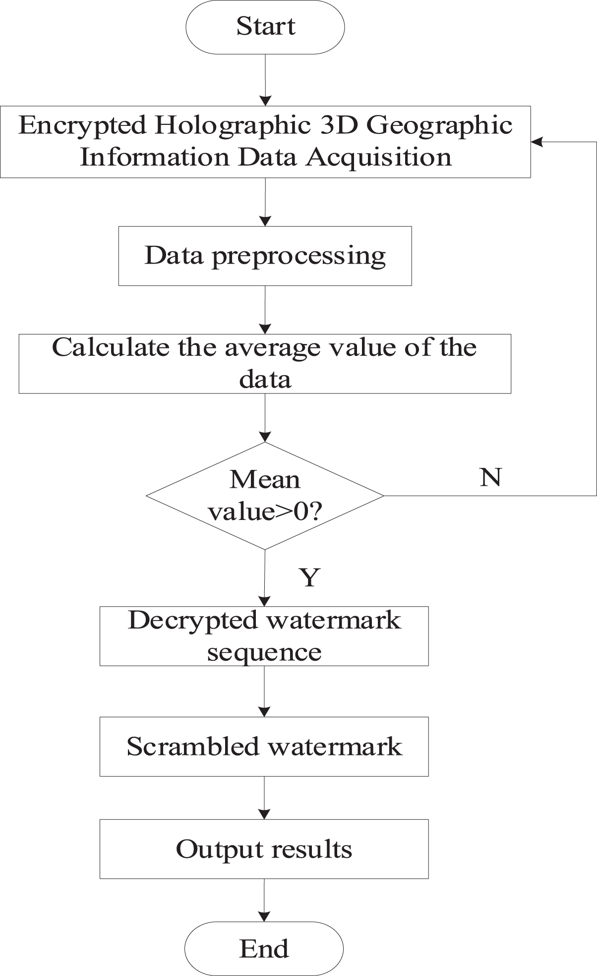
Blind Watermark Extraction Process.
According to the blind watermark extraction process shown in Fig. 5, the mean value is calculated by collecting and preprocessing the encrypted holographic 3D geographic information data. If the mean value is greater than 0, the watermark sequence is decrypted, and the watermark output result is replaced according to the sequence; If the mean value is less than or equal to 0, the encrypted holographic 3D geographic information data acquisition step will be returned and reprocessed until the mean value is greater than 0. Assuming that the selected watermark information is X′, the watermark sequence Y′ before reverse scrambling is:
According to the mapping mechanism, a binary sequence is generated, and the watermark sequence before the inverse scrambling is decrypted to obtain a one-dimensional sequence; The dimension of one-dimensional sequence is raised to obtain two-dimensional image, and the dimension raising process is the blind watermark extraction process of encrypted holographic three-dimensional geographic information data.
According to the blind watermark extraction process of encrypted holographic 3D geographic information data, a mapping mechanism is used to detect the blind watermark when the blind watermark characteristics are known. With the blind watermark signal as the input, the detection implementation diagram is shown in Fig. 6.
Implementation of blind watermark detection.
As shown in Fig. 6, each transmitter is assigned a unique blind watermark feature S r , the transmitter status information is represented by serial information, and the video information is encoded using the watermark feature S r to obtain the information mode s m , which is expressed as:
In Formula (12), β represents the watermark strength, k represents the demodulated watermark signal, and H K represents the detected watermark information. The obtained blind watermark information is divided into encrypted holographic 3D geographic data information using quadtree algorithm to form a block data organization. The detection of blind watermark is as follows:
Step 1: Assume that the encrypted holographic 3D geographic data information is in a rectangular area;
Step 2: The rectangular area is divided into four quadrants;
Step 3: Determine the encrypted holographic 3D geographic data information and the quadtree node type structure;
Step 4: Judge the rectangular area represented by the node;
Step 5: In node data and node type, multiple geographic data information is stored;
Step 6: Form a quadtree node branch;
Step 7: Determine the quadtree type structure and depth;
Step 8: Connect all nodes;
Step 9: Output the block results of encrypted holographic 3D geographic data information.
The block results of encrypted holographic 3D geographic data obtained from the above process are fused to obtain the hierarchical processing results of high-resolution geographic information. Under the effect of the mapping mechanism, the coordination and distribution planning of the established extraction nodes are realized, so as to achieve the purpose of enhancing the actual resolution level of encrypted holographic 3D geographic information. In general, if the information is known to use the extraction results of records, the extreme value transmission status can be achieved in a short time by planning the data extraction capability of the system host. Suppose that M represents the information storage right limit index of the database in this process, and
In Formula (13), α and β represent two different high-resolution extraction coefficients respectively. So far, under the support of the mapping mechanism, the research on the design of blind watermarking algorithm for encrypted holographic 3D geographic information data has been realized.
In order to verify the feasibility of the blind watermarking algorithm for encrypted holographic 3D geographic information data based on the mapping mechanism, experiments are carried out. The results of the experiment must be operable and authentic, so the data of the entire experiment should be collated in the Windows 10 operating system. The construction process of encrypted holographic 3D geographic information data blind watermark selects ATI series graphics cards with high display degree, and uses Visual #Cit##/it#++6.0 programming language to design the construction process of data blind watermark. In this experiment, dynamic technology is also involved, so the transmission interface of the experimental results is set as the Oben API interface to complete the building process of the experimental platform, and this platform is applied in this experiment. At the same time, the topological structure of the operating environment of the blind watermarking algorithm is set, as shown in Fig. 7.
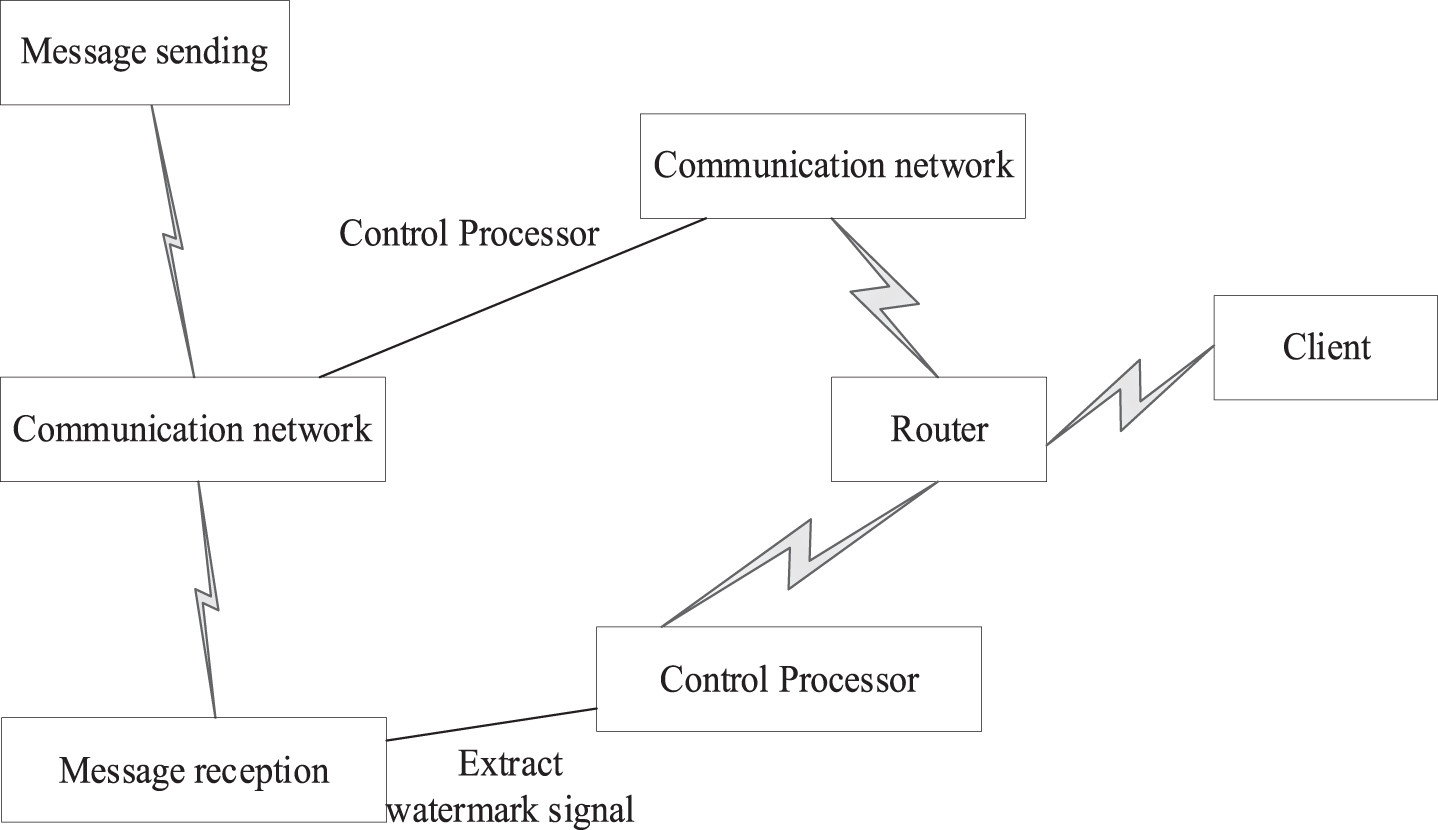
Topological structure of the operating environment of the blind watermarking algorithm.
According to the above built test environment, the specific test is finally carried out, and the test process is shown in Fig. 8.
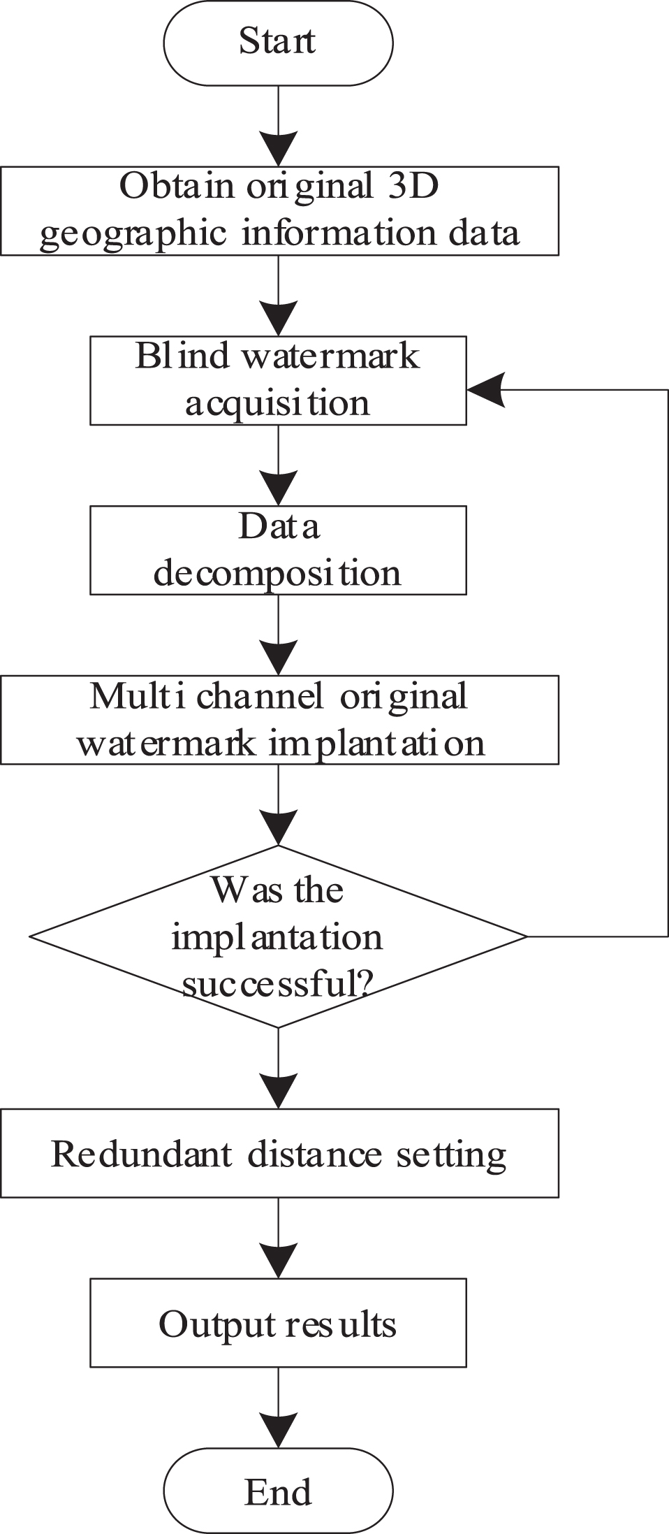
Test Structure Flow Chart.
According to the structure flow in Fig. 8, the test can finally be completed and the test results are compared and analyzed. The reference [6] algorithm and the reference [7] algorithm are used as the control group, and the method in this paper is used as the experimental group to verify the resistance of the three groups of algorithms to attacks through correlation coefficients. The closer the correlation coefficient of the algorithm is to 1, the higher the similarity between the watermark information extracted by the blind watermark algorithm and the original watermark, the better the anti attack ability of the algorithm. Therefore, if the original watermark is D
s
and the extracted watermark is D
s
′, the correlation coefficient C of the algorithm is calculated as follows:
In formula (14), w (x, y) represents the pixel at a certain position of the watermark, w′ (x, y) represents the extracted pixel at a certain position of the watermark, i and j represent the pixel points of the watermark, Matalab software is selected, and low-pass filtering, down sampling attack, noise removal attack, gravimetric attack, up sampling attack and other attacks are selected to attack the three algorithms selected in this experiment, and formula (14) is used to calculate the correlation coefficients of the three algorithms, Verify the resistance of the three algorithms to attacks, and the experimental results are shown in Table 1.
Test results of resistance to attacks under three algorithms
As can be seen from Table 1, when none of the three algorithms are attacked, their phase relation values are all 1. Under the attack mode set in this experiment, the correlation coefficient results of the algorithm in this paper have a small change range, while those of the algorithm in literature [6] and the algorithm in literature [7] have a large change range. According to the statistics of the average correlation coefficients of the three algorithms, the similarity coefficient of the method in this paper is 0.985, and the average values of the algorithm in literature [6] and the algorithm in literature [7] are 0.868 and 0.835, respectively. Compared with the three, the similarity coefficient of the proposed algorithm is closer to 1, and the similarity between the watermark information extracted by the two literature algorithms and the original watermark is lower than that of the proposed algorithm, and the anti-attack performance is poor when attacked. In the attack mode set in this experiment, the correlation coefficient of the algorithm in this paper has a maximum gap of 0.04 between the correlation coefficient of the algorithm that is not attacked. Therefore, it can be shown that the watermark information extracted by the algorithm in this paper has a high similarity to the original watermark, and has better anti-aggression when attacked.
Encrypted holographic 3D geographic information data acquisition is the basis for topographic mapping map drawing and data linkage updating. To test the data acquisition capability of the algorithm in this paper, eight different test points are selected and set as test point A, test point B, test point C, test point D, test point E, test point F, test point G and test point H respectively, so as to fully display the blind watermark algorithm and effect, At the same time, the algorithm in Reference [6] and the algorithm in Reference [7] are used for data collection test, and the results are shown in Table 2.
Test Results of Encrypted Holographic 3D Geographic Information Data Acquisition
In Table 2, Y represents the locations where data collection has been completed and N represents the locations where data collection has not been completed. It can be seen from the analysis in Table 2 that during the data collection of eight test points, the reference algorithm [6] did not collect the topographic data of points B, E and G, while the reference algorithm [7] did not collect the topographic data of five test points C, E, F and H. However, the terrain data collection of the 8 test points is complete because the encrypted holographic 3D geographic information data collection method adopted by the algorithm has a wide range of terrain data collection and is not affected by complex terrain, so it has good terrain information collection ability.
The error compensation of encrypted holographic 3D geographic information data blind watermarking algorithm is a necessary means to improve the high accuracy of topographic mapping map. Take a group of encrypted holographic 3D geographic information data to draw a curve, and use three algorithms to compensate the error of this group of data. The results are shown in Fig. 9.
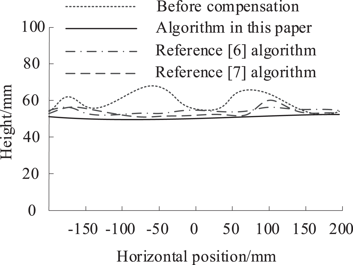
Test Results of Error Compensation for Three Methods of Encrypting Holographic 3D Geographic Information Data.
It can be seen from the analysis of Fig. 9 that the encrypted holographic 3D geographic information data curve before error compensation is wavy. After error compensation processing of the encrypted holographic 3D geographic information data with three algorithms, the encrypted holographic 3D geographic information data curve is smoother than that before error compensation processing, Among them, although the encrypted holographic 3D geographic information data curve after error compensation processing of reference [6] algorithm and reference [7] algorithm tends to be horizontal at a certain horizontal position, there is still a small fluctuation. However, the encrypted holographic 3D geographic information data curve after error compensation processing of this method is almost a straight line, and the curvature of encrypted holographic 3D geographic information data has been repaired to the maximum extent, The error compensation effect of encrypted holographic 3D geographic information data is good, and the high precision of topographic map can be better improved
Conclusion
This paper studies the blind watermarking algorithm of encrypted holographic 3D geographic information data based on mapping mechanism, and the following conclusions are obtained through experiments: When the watermark is not attacked, the value of phase relation is 1. In the attack mode set in this experiment, the correlation coefficient of the algorithm in this paper has a maximum gap of 0.04 between the correlation coefficient of the algorithm that is not attacked. The extracted watermark information has high similarity to the original watermark. When attacked, the algorithm has better anti-attack ability. 8 terrain data acquisition test points are set. The results show that the encrypted holographic 3D geographic information data acquisition method adopted by the algorithm in this paper can completely collect the terrain data of the 8 test points, and the terrain data collected has a wide range and is not affected by complex terrain, so it has good terrain information acquisition ability. The curve of encrypted holographic 3D geographic information data before error compensation is wavy. The curve of encrypted holographic 3D geographic information data after error compensation processing using this method is almost a straight line, and the curvature of encrypted holographic 3D geographic information data is repaired to the maximum extent.
Prospect
Although the research algorithm has made some progress, the blind watermarking algorithm for encrypted holographic 3D geographic information data is still a new research field, there are many untouched research topics, and the existing technology also needs to be improved. To this end, the possible future research directions of the algorithm are given as follows: The future research on blind watermarking algorithms for encrypted holographic 3D geographic information data needs to analyze the weaknesses of existing algorithms and improve them, refer to the model of human sensory system, explore new hiding ways, and find new parametric modeling methods, so that the existing mature blind watermarking algorithms can be applied to 3D geometric models. Determine the ability of different busy watermarking algorithms to withstand various attacks, that is, the attack analysis of blind watermarking, to promote the continuous improvement of the watermarking system, and hope to find appropriate anti attack means from the perspective of watermark attack analysis. The biggest obstacle to the wide application of blind watermarking algorithm lies in the robustness against nontrivial attacks. If the cost of breaking a watermark is high enough, then the blind watermarking algorithm for encrypted holographic 3D geographic information data needs to be further studied in the future. At the same time, there are many technical problems, management problems and legal problems that need to be solved when the algorithm is really applied. How to make the blind watermarking algorithm truly serve the economic development of the digital information age is a noteworthy problem.
Footnotes
Acknowledgments
The study was supported by “In 2021, Wenzhou Basic Scientific Research Project “Research on the Security Key Technology of Real Scene 3D Geographic Information Data Application” (No.: S20210017)”; “Research on Key Technology of Security Application of Zhejiang Provincial Department of Natural Resources” of Three-dimensional Geographic Information Security “ (No.: 2021-34)”.