Other
 Restricted accessOtherFirst published May, 2024pp. 1-8

Select search scope: search across all journals or within the current journal


 Restricted accessOtherFirst published May, 2024pp. 1-8Restricted accessResearch articleFirst published May, 2024pp. 913-938
 , [...]
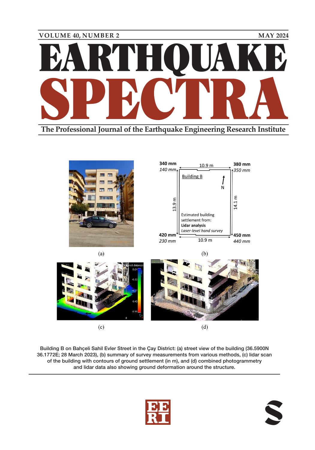
Significant and widespread liquefaction occurred in İskenderun during the 2023 moment magnitude (Mw) 7.8 Kahramanmaraş earthquake. Liquefaction effects on buildings were observed in several areas of İskenderun, predominantly in areas of reclaimed land and near historic shorelines. Liquefaction-induced building settlements were particularly concentrated in the Çay District, which is almost entirely reclaimed land. Liquefaction-induced ground and building settlements were either marginal or not apparent in areas away from the historical shorelines. Building settlement and ground deformation were documented at 26 buildings in İskenderun through lidar scans and laser-level hand measurements. Liquefaction-induced building settlements ranged from 0 to 740 mm. Building-ground interactions were evident from hogging ground deformations, including cases where buildings deformed nearby ground and damaged nearby buildings, and sagging buildings. Historic land development affected the spatial extent of observed liquefaction-induced building damage. Representative liquefaction-induced building settlement and building interaction case histories are discussed and key insights are shared.
Restricted accessResearch articleFirst published May, 2024pp. 939-976, Robb Eric S MossThe earthquake sequence that occurred on 6 February 2023 in Turkiye caused significant damage to various infrastructures including geostructures such as dams. A total of 17 earth dams within a 200-km radius of the earthquake epicenter experienced varying degrees of damage, ranging from minor (∼2 cm) to major (up to ∼150 cm) deformations. As study of these reveals that the damaged dams are located within the closest distance to the fault of less than 30 km, with an average value of ∼12 km. This study specifically focuses on the seismic displacement analysis of the 17 damaged dams, utilizing the sliding block methods. The recorded motion data was analyzed using the kriging technique to estimate the spectral response at the dam sites. Moreover, the recorded ground motions were scaled to the resonant period of the dam site to estimate acceleration time history. The findings reveal that the rigid block analysis can provide an average estimation of seismic displacement with a relative error of less than 44%. The results of the damage analysis indicate that seven dams reached the ultimate limit state and two dams experienced the serviceability limit state. Moreover, the univariate and multivariate fragility functions are developed to estimate seismic probabilistic analysis of earth dams based on the observed data and the limit states. The results show that the selection of a single intensity measure (IM) and a combination of IMs can affect the predicted probability of failure. The findings provide an insight into the resilience assessment of dams and other geosystems during this strong earthquake.
Restricted accessResearch articleFirst published May, 2024pp. 977-996, Che-Min Lin, Jyun-Yan HuangNear-fault pulse-like (PL) ground motions generally transmit huge amounts of energy into structures during a relatively short period compared with non-pulse-like (NPL) ground motions. Consequently, power demand has emerged as a direct and distinctive measure for evaluating the risk that PL ground motions pose on structures. This study examines the power demands of structures subjected to ground motions recorded at 10 seismic stations in six city (or town) centers during the Mw 7.8 earthquake that hit Türkiye on 6 February 2023. The six cities (or towns), Golbasi, Kahramanmaras, Nurdagi, Osmaniye, Iskenderun, and Antakya, were the locations where an international team conducted field reconnaissance 2 weeks after the earthquake. This study first evaluates the power histories and other seismic responses of single-degree-of-freedom structures exposed to both PL and NPL ground motions. Subsequently, the power spectra of 20 horizontal ground motions recorded at the 10 stations are constructed and examined. Through these investigations, we hope to gain a better understanding of and raise awareness regarding the threats that PL ground motions pose to structures in the six cities (or towns) during the earthquake.
Restricted accessResearch articleFirst published May, 2024pp. 997-1018A series of large-scale earthquakes occurred on February 6 in southern Turkey. The authors had the opportunity to join the Japan Disaster Relief (JDR) Expert Team and visit several damaged areas in Turkey from March 10 to 12, 2023. This article highlights damage cases of a road tunnel and several road bridges the authors observed around Antakya, Nurdağı, and Malatya. From the features of the observations, this article discusses the following three items for further study in the seismic design of road bridges: (1) seismic details for robustness, (2) seismic responses of bridges with longer natural periods, and (3) post-event inspection.
Restricted accessResearch articleFirst published May, 2024pp. 1019-1041At present time, ground-motion prediction models neglect the directionality observed in horizontal components of earthquake ground motions, that is, the important changes in ground-motion intensity that occur with changes in azimuth. This study presents an investigation of the directionality of a recently proposed measure of ground-motion intensity during the 6 February 2023, Mw 7.8 Pazarcık and Mw 7.5 Elbistan earthquake doublet in the Kahramanmaraş region of Türkiye, which resulted in the collapse of more than 35,000 buildings and caused almost 60,000 fatalities. The studied intensity measure is referred to as FIV3, which has been shown to be better correlated with structural collapse than the spectral acceleration at the fundamental period of the structure. The improved intensity measure is period-dependent and is computed as the sum of the three largest incremental velocities with the same polarity obtained from the area under segments of a low-pass filtered ground acceleration time series. The following aspects are studied in this article: variation of FIV3 intensity with changes in the orientation; variation of FIV3 intensity with changes in the period of vibration; attenuation of FIV3 intensities with increasing distance; and spatial distribution of the orientation of maximum FIV3 intensity. This study is based on 231 pairs of records from the Mw 7.8 main event and 222 pairs of records from the Mw 7.5 event. Similarly to the directionality of spectral ordinates, it is found that the directionality of FIV3 intensity also increases with increasing period. Strong directionality occurred not only in the near field but up to distances as large as 400 km from the epicenter. The orientation of maximum FIV3 intensity is found to occur close to the transverse orientation, consistent with observations for the orientation of maximum spectral ordinates during strike-slip earthquakes.
 Open accessResearch articleFirst published May, 2024pp. 1042-1065
We develop basin-depth-scaling models (i.e. “basin terms”) from the long-period (
Open accessResearch articleFirst published May, 2024pp. 1066-1098Several rupture directivity models (DMs) have been developed in recent years to describe the near-source spatial variations in ground-motion amplitudes related to propagation of rupture along the fault. We recently organized an effort toward incorporating these directivity effects into the US Geological Survey (USGS) National Seismic Hazard Model (NSHM), by first evaluating the community’s work and potential methods to implement directivity adjustments into probabilistic seismic hazard analysis (PSHA). Guided by this evaluation and comparison among the considered DMs, we selected an approach that can be readily implemented into the USGS hazard software, which provides an azimuthally varying adjustment to the median ground motion and its aleatory variability. This method allows assessment of the impact on hazard levels and provides a platform to test the DM amplification predictions using a generalized coordinate system, necessary for consistent calculation of source-to-site distance terms for complex ruptures. We give examples of the directivity-related impact on hazard, progressing from a simple, hypothetical rupture, to more complex fault systems, composed of multiple rupture segments and sources. The directivity adjustments were constrained to strike–slip faulting, where DMs have good agreement. We find that rupture directivity adjustments using a simple median and aleatory adjustment approach can affect hazard both from a site-specific perspective and on a regional scale, increasing ground motions off the end of the fault trace up to 30%–40% and potentially reducing it for sites along strike. Statewide hazard maps of California show that the change in shaking along major faults can be a factor to consider for assessing long-period
Open accessResearch articleFirst published May, 2024pp. 1099-1131We assess how well the Next-Generation Attenuation-West 2 (NGA-West2) ground-motion models (GMMs), which are used in the US Geological Survey’s (USGS) National Seismic Hazard Model (NSHM) for crustal faults in the western United States, predict the observed basin response in the Great Valley of California, the Reno basin in Nevada, and Portland and Tualatin basins in Oregon. These GMMs rely on site parameters such as the time-averaged shear-wave velocity (
Open accessResearch articleFirst published May, 2024pp. 1132-1157Model development in the Next Generation Attenuation-East (NGA-East) project included two components developed concurrently and independently: (1) earthquake ground-motion models (GMMs) that predict the median and aleatory variability of various intensity measures conditioned on magnitude and distance, derived for a reference hard-rock site condition with an average shear-wave velocity in the upper 30 m (
Open accessResearch articleFirst published May, 2024pp. 1158-1190We update the ground-motion characterization for the 2023 National Seismic Hazard Model (NSHM) for the conterminous United States. The update includes the use of new ground-motion models (GMMs) in the Cascadia subduction zone; an adjustment to the central and eastern United States (CEUS) GMMs to reduce misfits with observed data; an updated boundary for the application of GMMs for shallow, crustal earthquakes in active tectonic regions (i.e. western United States (WUS)) and stable continental regions (i.e. CEUS); and the use of improved models for the site response of deep sedimentary basins in the WUS and CEUS. Site response updates include basin models for the California Great Valley and for the Portland and Tualatin basins, Oregon, as well as long-period basin effects from three-dimensional simulations in the Greater Los Angeles region and in the Seattle basin; in the CEUS, we introduce a broadband (0.01- to 10-s period) amplification model for the effects of the passive-margin basins of the Atlantic and Gulf Coastal Plains. In addition, we summarize progress on implementing rupture directivity models into seismic hazard models, although they are not incorporated in the 2023 NSHM. We implement the ground-motion characterization for the 2023 NSHM in the US Geological Survey’s code for probabilistic seismic hazard analysis,
Restricted accessResearch articleFirst published May, 2024pp. 1191-1214Limited availability of recorded ground motions poses a challenge for reliable probabilistic seismic-hazard analysis (PSHA), even in highly seismic regions like the Western United States. Stochastic ground motions are commonly employed to address this challenge. However, the stochastic ground motion models (GMMs) may not consistently generate ground motions compatible with the site hazard due to their calibration using global data, failing to capture site-specific characteristics adequately. In the absence of recorded motions, physics-informed simulations provide a viable alternative but are deterministic with limitations of their own that makes them challenging to support PSHA. This article introduces a Bayesian framework that combines prior knowledge from a stochastic GMM, calibrated with global data, with site-specific data obtained from deterministic physics-informed simulations. The proposed framework utilizes the Rezaeian–Der Kiureghian (2010) model as the stochastic GMM and incorporates site-specific data from the CyberShake 15.12 study. By updating the mean and variance of the predictive relationships, along with the marginal distribution of the model parameters, through Bayesian inference, this framework allows for the simulation of site-specific ground motions consistent with the site characteristics. The statistics of peak ground acceleration distributions, as well as both the median and variability of the elastic response spectra, obtained from the calibrated stochastic GMM, demonstrate consistency with those derived using GMMs based on the Next Generation Attenuation (NGA) database.
Open accessResearch articleFirst published May, 2024pp. 1215-1234, Yufeng Dong, Jorge GF Crempien , [...]One-dimensional (1D) site response analysis (SRA), which considers vertically propagating seismic waves from the bedrock to the surface, has been a common technique among geotechnical engineers to examine site-specific ground shaking. However, observations from past earthquakes and analytical studies indicate that idealizations ingrained in 1D SRA may be too severe to capture the ground truth, such as the omissions of spatial variability of soil properties, surface topography, and basin and directivity effects. Physics-based three-dimensional ground motion simulations (GMSs) can incorporate these factors and yield more reliable predictions. In this study, we utilize ground motions from 57 physics-based broadband (from 0 to 8–12 Hz) GMS for a region of Istanbul. A total of 2912 sites with experimentally measured soil profiles that are distributed over the 30 km-by-12.5 km area are also modeled as soil columns and analyzed through 1D SRA. The ground responses from 1D SRA and three-dimensional (3D) GMS are then compared for all 57 earthquake scenarios. These systematic comparisons are then used for examining model features that are correlated with variations in the ratios of various ground motion intensity measures (IMs) and for developing regression-based formulas that can be used for determining simple factors for the considered region to correctly scale (up or down) the site-specific ground motion intensities obtained from 1D SRA, including peak ground acceleration (PGA), peak ground velocity (PGV), and spectral acceleration (
Restricted accessResearch articleFirst published May, 2024pp. 1235-1268, Daniel Swensen, Hamid Haddadi , [...]This study presents a two-step hybrid (model-data fusion) method for reconstructing the seismic response of instrumented buildings at their non-instrumented floors. Over the past couple of decades, seismic data recorded within instrumented buildings have yielded invaluable insights into the behavior of civil structures, which were arguably impossible to obtain through numerical simulations, laboratory-scale experiments, or even in-situ testing. Recently, advances in sensing technology have opened new pathways for structural health monitoring (SHM) and rapid post-earthquake assessment. However, data-driven techniques tend to lack accuracy when structures have sparse instrumentation. In addition, creating detailed numerical models for the monitored structures is labor-intensive and time-consuming, often unsuitable for rapid post-event assessments. The common approach to address these challenges has been to use simple interpolation techniques over the sparse measurements. However, uncertainties associated with such estimates are usually overlooked, and these methods have certain physical limitations. In this study, we propose a two-step approach for reconstructing seismic responses. In the initial step, a coupled shear–flexural beam model is calibrated using data collected from instrumented floors. Next, the residual, representing the difference between measurements and the beam model’s predictions, is used to train a Gaussian process regression model. The combination of these two models provides both the mean and variance of the response at the non-instrumented floors. This new approach is verified by using simulated acceleration responses of a tall building. Validation is attained by using real seismic data recorded in two tall buildings and comparing the method’s predictions with actual measurements on floors not used for training. Finally, data recorded in a 52-story building during multiple earthquakes are used for demonstrating the practical application of the proposed approach in real-world scenarios.
Restricted accessResearch articleFirst published May, 2024pp. 1269-1300The Atlantic and Gulf Coastal Plains (CPs) are characterized by widespread accumulations of low-velocity sediments and sedimentary rock that overlay high-velocity bedrock. Geology and sediment thickness greatly influence seismic wave propagation, but current regional ground motion amplification and seismic hazard models include limited characterization of these site conditions. In this study, a new regional seismic velocity model for the CPs is created by integrating shear wave velocity (VS) measurements, surface geology, and a sediment thickness model recently developed for the CPs. A reference rock VS of 3000 m/s has been assumed at the bottom of the sedimentary columns, which corresponds to the base of Cretaceous and Mesozoic sediments underlying the Atlantic CP and the Gulf CP, respectively. Measured VS profiles located throughout the CPs are sorted into five geologic groups of varying age, and median VS profiles are developed for each group by combining measured VS values within layer thicknesses defined by an assumed layering ratio. Statistical analyses are also conducted to test the appropriateness of the selected groups. A power law model with geology-informed coefficients is used to extend the median velocity models beyond the depths where measured data were available. The median VS profiles provide reasonable agreement with other generic models applicable for the region, but they also incorporate new information that enables more advanced characterizations of site response at regional scales and their effective incorporation into seismic hazard models and building codes. The proposed median velocity profiles can be assigned within a grid-based model of the CPs according to the spatial distribution of geologic units at the surface.
Restricted accessResearch articleFirst published May, 2024pp. 1301-1323, Jonathan Bray, Norman AbrahamsonPerformance-based procedures represent an improvement over current state-of-practice procedures that treat the assessment of seismic demand and engineering response parameters independently. Procedures used in current practice generally provide estimates of liquefaction-induced ground settlement that are inconsistent with the desired ground settlement hazard level. A recently developed probabilistic procedure to estimate liquefaction-induced ground settlement is employed to develop a new performance-based procedure that estimates ground settlement which accounts for key sources of uncertainty. The ground-motion intensity and ground settlement estimations are integrated in the proposed procedure to produce hazard curves for liquefaction-induced ground settlement. The hazard curve for ground settlement links different hazard levels with their corresponding values of ground settlement by evaluating a wide range of ground-motion intensities and site characterization parameters with their associated uncertainties. The proposed performance-based procedure also permits the evaluation of different sources of uncertainty and their effects on the ground settlement estimate.
Restricted accessResearch articleFirst published May, 2024pp. 1324-1352, Dimitris PitilakisOur study introduces a methodology to improve large-scale seismic damage assessment by incorporating site-specific fragility curves, considering soil–structure interaction (SSI) and site amplification (SAmp) effects. The proposed method proposes an enhanced building exposure model, using publicly available data and the open-source OpenQuake Engine software. The objective is to determine whether a more refined approach incorporating SSI and SAmp can impact the final damage calculation. We evaluate our approach by estimating the damage distribution for the Thessaloniki 1978 earthquake scenario using the actual building stock of Thessaloniki. We present several maps with aggregated damages at different levels to investigate the spatial variability of SSI and SAmp, and their influence on the resulting damages. Our estimated physical damages have been compared with those obtained using approaches from the existing literature. Apparently, using an updated building exposure model to assess damages makes any comparison with past observed damages challenging. Nevertheless, incorporating SSI and SAmp in large-scale damage assessment can provide valuable support for strategic decision-making in cities and improve the accuracy of the expected loss assessment due to a seismic event.
Restricted accessResearch articleFirst published May, 2024pp. 1353-1375Post-disaster housing recovery models increase our understanding of recovery dynamics, vulnerable populations, and how people are affected by the direct losses that disasters create. Past recovery models have focused on single-family owner-occupied housing, while empirical evidence shows that rental units and multi-family housing are disadvantaged in post-disaster recovery. To fill this gap, this article presents an agent-based housing recovery model that includes the four common type–tenure combinations of single- and multi-family owner- and renter-occupied housing. The proposed model accounts for the different recovery processes, emphasizing funding sources available to each type–tenure. The outputs of our model include the timing of financing and recovery at building resolution across a community. We demonstrate the model with a case study of Alameda, California, recovering from a simulated M7.0 earthquake on the Hayward fault. The processes in the model replicate higher non-recovery of multi-family housing than single-family housing, as observed in past disasters, and a heavy reliance of single-family renter-occupied units on Small Business Administration funding, which is expected due to low earthquake insurance penetration. The simulation results indicate that multi-family housing would have the highest portion of unmet need remaining; however, some buildings with unmet needs are anticipated to be able to obtain a large portion of their funding. The remaining portion may be filled using personal financing or may be overcome with downsizing or downgrades. Multi-family housing would also benefit the most from Community Development Block Grants for Disaster Recovery (CDBG-DR). This benefit is a result of modeling the financing sources, that CDBG-DR is available, and that many multi-family buildings do not qualify for other sources. Communities’ allocation of public funding is important for housing recovery. Our model can help inform and compare potential financing policies to allocate public funds.
Open accessResearch articleFirst published May, 2024pp. 1376-1395Conventional earthquake risk modeling involves several notable simplifications, which neglect: (1) the effects on seismicity of interactions between adjacent faults and the long-term elastic rebound behavior of faults; (2) short-term hazard increases associated with aftershocks; and (3) the accumulation of damage in assets due to the occurrence of multiple earthquakes in a short time window, without repairs. Several recent earthquake events (e.g. 2010–2011 Canterbury earthquakes, New Zealand; 2019 Ridgecrest earthquakes, USA; and 2023 Turkey–Syria earthquakes) have emphasized the need for risk models to account for the aforementioned short- and long-term time-dependent characteristics of earthquake risk. This study specifically investigates the sensitivity of monetary loss (i.e. a possible earthquake-risk-model output) to these time dependencies, for a case-study portfolio in Central Italy. The investigation is intended to provide important insights for the catastrophe risk insurance and reinsurance industry. In addition to salient catastrophe risk insurance features, the end-to-end approach for time-dependent earthquake risk modeling used in this study incorporates recent updates in long-term time-dependent fault modeling, aftershock forecasting, and vulnerability modeling that accounts for damage accumulation. The sensitivity analysis approach presented may provide valuable guidance on the importance and appropriate treatment of time dependencies in regional (i.e. portfolio) earthquake risk models. We find that the long-term fault and aftershock occurrence models are the most crucial features of a time-dependent seismic risk model to constrain, at least for the monetary loss metrics examined in this study. Accounting for damage accumulation is also found to be important, if there is a high insurance deductible associated with portfolio assets.
Open accessResearch articleFirst published May, 2024pp. 1396-1424The detailed evaluation of expected losses and damage experienced by structural and nonstructural components is a fundamental part of performance-based seismic design and assessment. The FEMA P-58 methodology represents the state of the art in this area. Increasing interest in improving structural performance and community resilience has led to widespread adoption of this methodology and the library of component models published with it. This study focuses on the modeling of economies of scale for repair cost calculation and specifically highlights the lack of a definition for aggregate damage, a quantity with considerable influence on the component repair costs. The article illustrates the highly variable and often substantial impact of damage aggregation that can alter total repair costs by more than 25%. Four so-called edge cases representing different damage aggregation methods are introduced to investigate which components experience large differences in their repair costs and under what circumstances. A three-step evaluation strategy is proposed that allows engineers to quickly evaluate the potential impact of damage aggregation on a specific performance assessment. This helps users of currently available assessment tools to recognize and communicate this uncertainty even when the tools they use only support one particular damage aggregation method. A case study of a 9-story building illustrates the proposed strategy and the impact of this ambiguity on the performance of a realistic structure. The article concludes with concrete recommendations toward the development of a more sophisticated model for repair consequence calculation.
Restricted accessResearch articleFirst published May, 2024pp. 1425-1451The ShakeAlert Earthquake Early Warning (EEW) system aims to issue an advance warning to residents on the West Coast of the United States seconds before the ground shaking arrives, if the expected ground shaking exceeds a certain threshold. However, residents in tall buildings may experience much greater motion due to the dynamic response of the buildings. Therefore, there is an ongoing effort to extend ShakeAlert to include the contribution of building response to provide a more accurate estimation of the expected shaking intensity for tall buildings. Currently, the supposedly ideal solution of analyzing detailed finite element models of buildings under predicted ground-motion time histories is not theoretically or practically feasible. The authors have recently investigated existing simple methods to estimate peak floor acceleration (PFA) and determined these simple formulas are not practically suitable. Instead, this article explores another approach by extending the Pacific Earthquake Engineering Research Center (PEER) performance-based earthquake engineering (PBEE) to EEW, considering that every component involved in building response prediction is uncertain in the EEW scenario. While this idea is not new and has been proposed by other researchers, it has two shortcomings: (1) the simple beam model used for response prediction is prone to modeling uncertainty, which has not been quantified, and (2) the ground motions used for probabilistic demand models are not suitable for EEW applications. In this article, we address these two issues by incorporating modeling errors into the parameters of the beam model and using a new set of ground motions, respectively. We demonstrate how this approach could practically work using data from a 52-story building in downtown Los Angeles. Using the criteria and thresholds employed by previous researchers, we show that if peak ground acceleration (PGA) is accurately estimated, this approach can predict the expected level of human comfort in tall buildings.
Restricted accessResearch articleFirst published May, 2024pp. 1452-1478, Christie Assadollahi, Arash ZandiehThe main objective of this study is to estimate seismological parameters in Central and Eastern North America (CENA), including the geometrical spreading, anelastic attenuation, stress parameter, and site attenuation parameters. In this study, we use particle swarm optimization (PSO) to invert a weighted average of the median 5%-damped pseudo-spectral acceleration (PSA) predicted from the Next Generation Attenuation-East (NGA-East) ground-motion models (GMMs) to develop a point-source stochastic GMM with a well-constrained set of ground-motion parameters. Magnitude-specific inversions are performed for moment magnitude ranges
Restricted accessResearch articleFirst published May, 2024pp. 1479-1506, Kim Bak OlsenWe have conducted three-dimensional (3D) 0–7.5 Hz physics-based wave propagation simulations to model the seismic response of the Long Valley Dam (LVD), which has formed Lake Crowley in Central California, to estimate peak ground motions and settlement of the dam expected during maximum credible earthquake (MCE) scenarios on the nearby Hilton Creek Fault (HCF). We calibrated the velocity structure, anelastic attenuation model, and the overall elastic properties of the dam via linear simulations of a Mw 3.7 event as well as the Mw 6.2 Chalfant Valley earthquake of 1986, constrained by observed ground motions on and nearby the LVD. The Statewide California Earthquake Center (SCEC) Community Velocity Model CVM-S4.26.M01 superimposed with a geotechnical layer using
Restricted accessResearch articleFirst published May, 2024pp. 1507-1520Synchronous rupture involving two or more antithetic or synthetic faults results in higher levels of ground shaking hazard compared to that computed separately for each fault. We describe methodologies to estimate the ground motions both deterministically and probabilistically using a square-root-sum-of-the-squares approach and provide a case study for the Salt Lake City segment of the Wasatch fault zone and the antithetic West Valley fault zone in the Salt Lake Valley, Utah. The amount of increased hazard between the fault pairs will depend on their fault dips and horizontal separation which will dictate their potential rupture areas and hence their maximum magnitudes. For the case study, the increased hazard between the Salt Lake City segment and the West Valley fault zone can range up to 30% primarily at short to moderate periods (<1 s).
Restricted accessResearch articleFirst published May, 2024pp. 1521-1551This study investigates how current practices of input ground-motion selection influence site response analysis results and their variability, when considering different tectonic settings. Study sites in Seattle and Boston are chosen to represent tectonic settings with contributions to the seismic hazard from shallow crustal and subduction events, as well as stable continental regions, respectively. Selected input ground-motion suites for one-dimensional site response analysis represent variations in the target spectrum definition, spectral period of interest, seismic source, and ground-motion database. When directly incorporating different types of seismic sources (e.g. shallow crustal versus subduction) into target spectrum definitions and selecting ground motions from the corresponding databases (i.e. consistent with such seismic sources), differences on the estimated site response and its variability are observed. These effects are captured by spectral amplification factors and nonspectral intensity measures (significant duration and Arias intensity) and become particularly apparent for subduction zones. The variability in spectral amplification factors stemming from ground-motion selection techniques is found to be also a function of the characteristics of the site, becoming higher near the fundamental period of the site. Estimated responses at stiffer sites are more significantly influenced by ground-motion selection techniques, whereas the onset of nonlinear soil behavior at softer sites can reduce such variability.
Open accessResearch articleFirst published May, 2024pp. 1552-1576The southern East African Rift System (EARS) is an early-stage continental rift with a deep seismogenic zone. It is associated with a low-to-moderate seismic hazard, but due to its short and sparse instrumental record, there is a lack of ground-motion studies in the region. Instead, seismic hazard assessments have commonly relied on a combination of active crustal and stable continental ground-motion models (GMMs) from other regions without accounting for the unusual geological setting of this region and evaluating their suitability. Here, we use a newly compiled southern EARS ground-motion database to compare six active crustal GMMs and four stable continental GMMs. We find that the active crustal GMMs tend to underestimate the ground-motion intensities observed, while the stable continental GMMs overestimate them. This is particularly pronounced in the high-frequency intensity measures (>5 Hz). We also use the referenced empirical approach and develop a new region-specific GMM for southern EARS. Both the ranked GMMs and our new GMM result in large residual variabilities, highlighting the need for local geotechnical information to better constrain site conditions.
Restricted accessResearch articleFirst published May, 2024pp. 1577-1590In the last decades, most efforts to catalog and characterize the built environment for multi-hazard risk assessment have focused on the exploration of census data, cadastral data sets, and local surveys. Typically, these sources of information are not updated regularly and lack sufficient information to characterize the seismic vulnerability of the building stock. Some recent efforts have demonstrated how machine learning algorithms can be used to automatically recognize specific architectural and structural features of buildings. However, such methods require large sets of labeled images to train, verify, and test the algorithms. This article presents a database of 5276 building images from a parish in Lisbon (Alvalade), whose buildings have been classified according to a uniform taxonomy. This database can be used for the testing and calibration of machine learning algorithms, as well as for the direct assessment of earthquake risk in Alvalade. The data are accessible through an open Github repository (DOI: 10.5281/zenodo.7625940).
Restricted accessDiscussionFirst published May, 2024pp. 1591-1599This is a Discussion of the following article: Cook D., et al. (2023). ASCE/SEI 41 assessment of reinforced concrete buildings: Benchmarking nonlinear dynamic procedures with empirical damage observations, Earthquake Spectra, August 2023, Vol. 39, No. 3, pp. 1721–1754.
Restricted accessResearch articleFirst published May, 2024pp. 1600-1603Resilience, achieving rapid recovery so that society can bounce back from a disaster, is a desirable goal, but sometimes the focus should be only on safety. The 2023 Turkey/Syria earthquake illustrates the case where limited resources should be prioritized on safety, that is, the collapse prevention performance objective, rather than the significantly more expensive goal of post-earthquake functionality.
Restricted accessBook reviewFirst published May, 2024pp. 1604-1606 Restricted accessBook reviewFirst published May, 2024pp. 1607-1610